")


Cassiterite

Cassiterite is a mineral composed of tin oxide (SnO2) and is the primary ore of tin. It has a high density and a hardness of 6 to 7 on the Mohs scale, making it relatively resistant to weathering and erosion. The name “cassiterite” is derived from the Greek word “kassíteros,” which means tin.
Historically, cassiterite has been an essential mineral due to its tin content. Tin is a versatile metal with various industrial applications. It is commonly used in the production of alloys, such as bronze, which is a mixture of tin and copper. Tin is also used in soldering materials, electrical components, and as a coating for other metals to prevent corrosion.
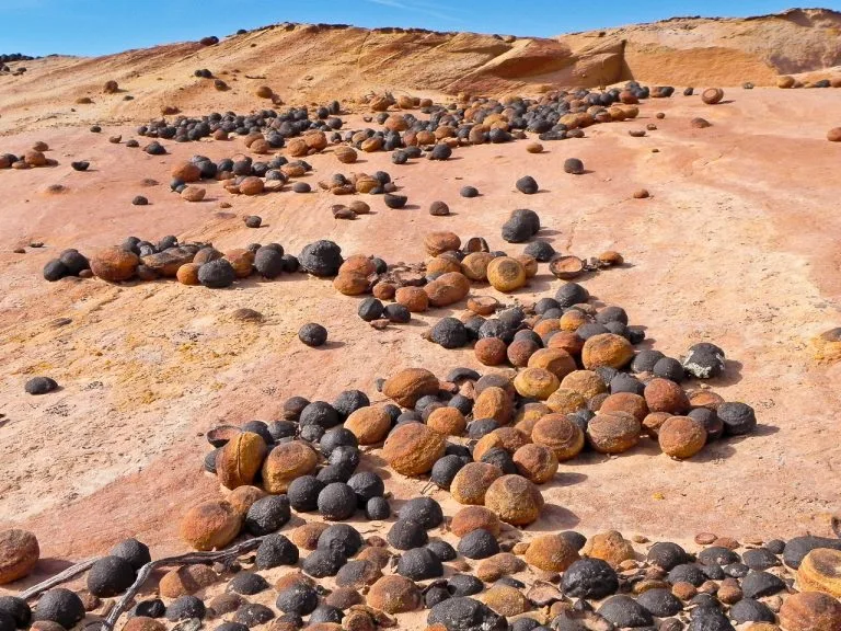
Cassiterite typically forms in hydrothermal veins and granite pegmatites, often associated with other minerals such as quartz, feldspar, and mica. It can also be found in alluvial deposits, which are accumulations of eroded minerals transported by rivers and streams.
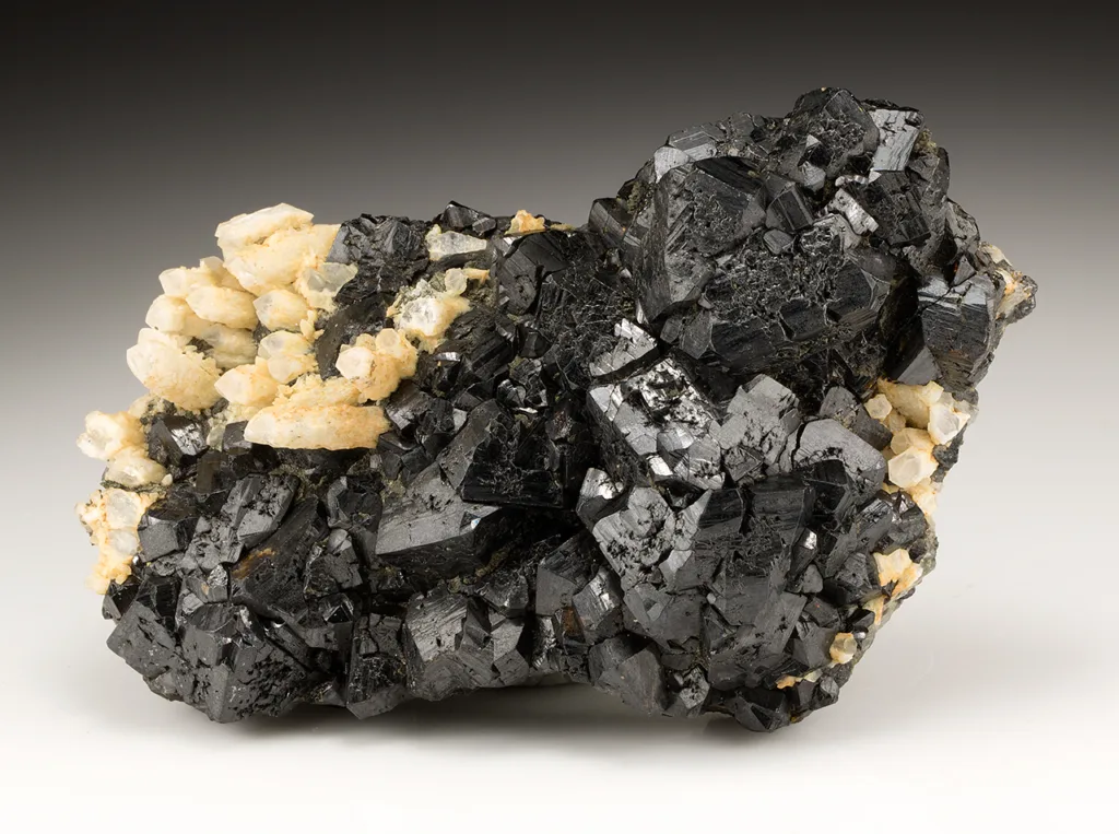
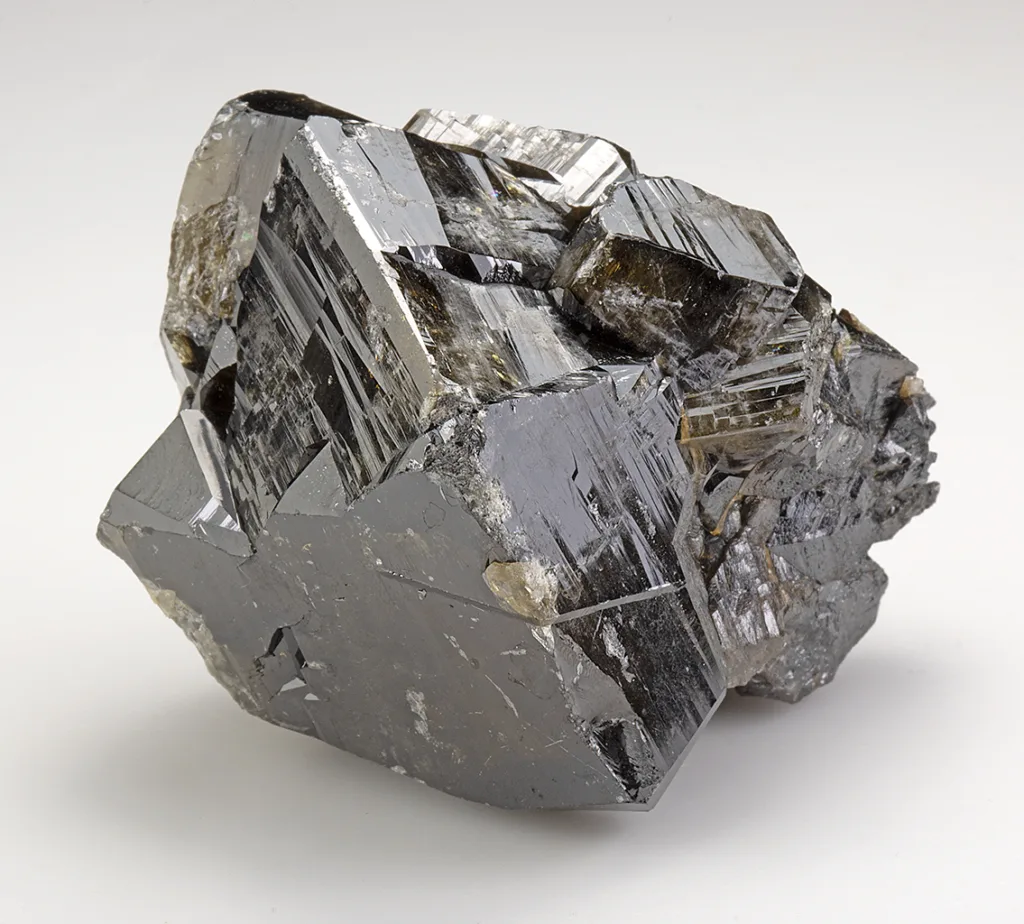
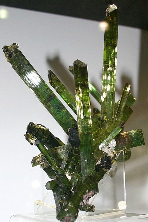
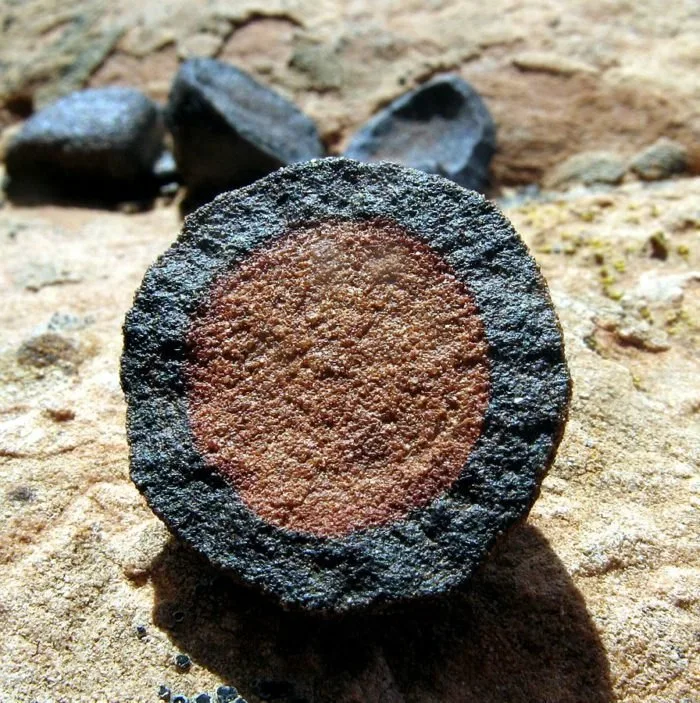
The color of cassiterite can vary, ranging from brown to black, with shades of red, yellow, or gray. Its crystal structure belongs to the tetragonal system, and it often occurs as prismatic or short, stubby crystals. Cassiterite can also appear as massive, granular, or as tin oxide-stained quartz.
Countries rich in cassiterite deposits include China, Indonesia, Malaysia, Thailand, Bolivia, and the Democratic Republic of Congo. These regions have historically been major producers of tin, and cassiterite mining has played a significant role in their economies.
Due to its economic value, cassiterite mining has raised concerns about environmental and social impacts. Mining operations can have adverse effects on ecosystems, including deforestation, soil erosion, and water pollution. Additionally, the mining industry has been associated with social issues such as labor rights abuses and conflicts over resource ownership.
Efforts are being made to promote responsible and sustainable mining practices to mitigate these concerns. Initiatives such as certification programs and traceability systems aim to ensure that cassiterite and other minerals are extracted and traded in an ethical and environmentally responsible manner.
In conclusion, cassiterite is a mineral that serves as the primary source of tin. It is valued for its industrial applications and is found in various geological settings worldwide. However, its extraction and trade present environmental and social challenges, which are being addressed through responsible mining practices.
Occurrence and mining locations
Cassiterite occurs in a variety of geological environments and can be found in several mining locations around the world. Here are some notable occurrences and mining regions:
- China: China is one of the largest producers of cassiterite, with significant deposits located in the Yunnan, Hunan, and Jiangxi provinces. The country has a long history of tin mining, and cassiterite is extracted from both primary hard-rock deposits and secondary alluvial deposits.
- Indonesia: Indonesia is another major producer of cassiterite, particularly on the island of Bangka. The Bangka Belitung Islands have abundant tin resources, and cassiterite is mainly extracted through offshore dredging and shallow mining.
- Malaysia: Malaysia has been a significant tin producer, and cassiterite deposits are found in the states of Perak, Selangor, and Pahang. In the past, Malaysia was one of the world’s largest tin producers, but production has declined in recent years.
- Bolivia: Bolivia has substantial cassiterite deposits, particularly in the region of Potosí. The mineral is commonly mined in combination with other minerals, such as wolframite and bismuthinite. The Huanuni mine is one of Bolivia’s largest tin-producing mines.
- Thailand: Thailand has cassiterite deposits in the southern part of the country, particularly in the Phuket and Krabi provinces. Tin mining in Thailand has a long history, and the country was once a major global tin producer.
- Democratic Republic of Congo (DRC): The DRC has significant cassiterite deposits in its eastern provinces, including North Kivu, South Kivu, and Katanga. However, mining in the DRC has been associated with conflict and concerns about illegal mining and human rights abuses.
- Brazil: Brazil is known for its cassiterite deposits in the Amazon region. The Pitinga mine in the state of Amazonas is one of the largest tin mines in Brazil, producing cassiterite as well as other minerals like tantalum and niobium.
These are just a few examples of cassiterite occurrences and mining locations. Other countries, such as Nigeria, Rwanda, Myanmar, and Australia, also have significant cassiterite deposits. The availability and accessibility of cassiterite can vary over time as mining operations evolve and new deposits are discovered.
Historical significance
Cassiterite has significant historical significance due to its association with tin, which has played a crucial role in human civilization. Here are some key aspects of its historical significance:
- Bronze Age: Cassiterite’s importance can be traced back to the Bronze Age, a period characterized by the widespread use of bronze, an alloy of tin and copper. Bronze was a revolutionary material that enabled the production of tools, weapons, and objects of artistic and cultural significance. Cassiterite was the primary source of tin for producing bronze, making it a critical mineral for technological advancements during this era.
- Maritime Exploration: During the Age of Discovery in the 15th and 16th centuries, European powers sought new trade routes and resources. Cassiterite played a vital role in this era as it was in high demand for maritime activities. Tin was used for coating the bottoms of ships to protect against barnacles and other forms of biofouling. This anti-fouling property of tin, derived from cassiterite, helped to increase the efficiency and longevity of ships during long voyages.
- Industrial Revolution: The Industrial Revolution, which began in the 18th century, brought significant advancements in manufacturing, transportation, and infrastructure. Cassiterite played a critical role during this period as tin became increasingly important for various industries. Tin was used in the production of tinplate for packaging food and beverages, as well as in the manufacturing of solder for electrical connections and alloys for machinery.
- Electronics and Technology: In the 20th century, cassiterite gained even more significance with the rise of electronics and technology. Tin is a key component in soldering materials used for joining electronic components, and it is an essential element in the production of integrated circuits and other electronic devices. The demand for tin, derived from cassiterite, continues to grow as technology advances.
- Economic Development: Throughout history, regions with significant cassiterite deposits have experienced economic growth and development. Mining operations have created employment opportunities, stimulated local economies, and contributed to the overall prosperity of nations. However, it’s important to note that the extraction and trade of cassiterite have also been associated with challenges such as environmental degradation, social issues, and conflicts over resources.
Overall, the historical significance of cassiterite lies in its role as the primary source of tin, a metal that has shaped human civilization through its applications in bronze production, maritime exploration, industrial development, and modern technology.
Physical and Chemical Properties of Cassiterite
Cassiterite, the mineral form of tin oxide (SnO2), possesses several distinctive physical and chemical properties. Here are some key characteristics:
Physical Properties:
- Color: Cassiterite commonly exhibits brown to black colors, but it can also occur in shades of red, yellow, or gray.
- Crystal System: It crystallizes in the tetragonal crystal system, forming prismatic or short, stubby crystals. It can also appear as massive, granular, or tin oxide-stained quartz.
- Hardness: Cassiterite has a hardness of 6 to 7 on the Mohs scale, making it relatively hard and resistant to scratching.
- Density: It has a high density ranging from 6.8 to 7.1 g/cm³, which is significantly denser than most common minerals.
- Cleavage: Cassiterite exhibits imperfect cleavage in three directions, forming distinct right angles.
Chemical Properties:
- Chemical Formula: The chemical formula of cassiterite is SnO2, indicating that it consists of one atom of tin (Sn) and two atoms of oxygen (O).
- Composition: It is composed of approximately 78.6% tin and 21.4% oxygen by weight.
- Luster: The mineral typically displays a resinous or adamantine luster when freshly broken, but it can become dull or earthy upon exposure to weathering processes.
- Transparency: Cassiterite is usually opaque, meaning that light does not pass through it.
- Streak: The streak of cassiterite, observed by rubbing the mineral on a porcelain plate, is typically white to gray.
Other Properties:
- Magnetism: Cassiterite is non-magnetic, meaning it does not exhibit magnetic properties.
- Melting Point: It has a high melting point of approximately 1,720 degrees Celsius (3,128 degrees Fahrenheit), making it stable at high temperatures.
- Refractive Index: The refractive index of cassiterite ranges from approximately 1.997 to 2.091, depending on the crystal orientation.
These physical and chemical properties contribute to the identification and characterization of cassiterite in geological and mineralogical studies.
Optical and electrical properties
Cassiterite exhibits certain optical and electrical properties, which further contribute to its characterization. Here are some key optical and electrical properties of cassiterite:
- Transparency: Cassiterite is typically opaque, meaning that light does not pass through it. However, thin fragments or sections of the mineral may exhibit translucency in some cases.
- Color and Pleochroism: Cassiterite commonly displays brown to black colors. It may also exhibit pleochroism, which means that the mineral can exhibit different colors when viewed from different crystallographic directions.
- Refractive Index: The refractive index of cassiterite varies depending on the crystal orientation. It typically ranges from approximately 1.997 to 2.091. The refractive index is a measure of how light is bent or refracted as it passes through the mineral.
Electrical Properties:
- Electrical Conductivity: Cassiterite is a non-conductive mineral, meaning it does not conduct electricity. Its electrical conductivity is relatively low.
- Dielectric Constant: The dielectric constant, also known as the relative permittivity, measures the ability of a material to store electrical energy in an electric field. Cassiterite has a relatively high dielectric constant, which can vary depending on factors such as impurities and temperature.
It’s important to note that while cassiterite itself does not possess significant electrical conductivity, it is often associated with other minerals that can exhibit electrical properties. For example, cassiterite can occur with minerals such as wolframite and tantalite, which are valued for their conductive properties.
These optical and electrical properties of cassiterite are important for mineral identification and can be studied using techniques such as polarized light microscopy, refractometry, and electrical conductivity measurements.
Formation and Geology of Cassiterite
Cassiterite typically forms in specific geological environments and is associated with certain types of rocks and mineralization processes. Here’s an overview of the formation and geology of cassiterite:
- Granite Pegmatites: One common setting for cassiterite formation is in granite pegmatites. Pegmatites are coarse-grained igneous rocks that form from the slow cooling and crystallization of magma. These pegmatites often contain a variety of minerals, including cassiterite. Tin-rich fluids, derived from the cooling magma, can infiltrate fractures and cavities within the pegmatite, leading to the deposition of cassiterite.
- Hydrothermal Veins: Cassiterite can also form in hydrothermal veins, which are formed by the circulation of hot, mineral-rich fluids in fractures or faults in the Earth’s crust. These fluids, often associated with granitic intrusions, can carry tin and other minerals, including cassiterite. As the hydrothermal fluids cool and react with the surrounding rocks, cassiterite can precipitate and accumulate in the veins.
- Alluvial Deposits: Alluvial deposits are another important source of cassiterite. Alluvial deposits are accumulations of sediments, including eroded minerals, transported and deposited by rivers, streams, or glaciers. Cassiterite, being a heavy mineral, can be transported by water and settle in riverbeds or floodplains. Over time, the sediments containing cassiterite can be buried, compacted, and cemented, forming alluvial deposits from which cassiterite can be extracted.
- Metamorphic Deposits: Cassiterite can also form in metamorphic deposits. Metamorphism occurs when pre-existing rocks undergo changes in temperature and pressure due to tectonic forces. During metamorphism, tin-bearing minerals may be subjected to chemical reactions and transformations, leading to the formation of cassiterite-rich zones within the metamorphic rocks.
The geology of cassiterite deposits varies depending on the specific geological setting. Countries such as China, Indonesia, Malaysia, Bolivia, and the Democratic Republic of Congo have significant cassiterite deposits associated with granitic intrusions, pegmatites, and hydrothermal systems. These deposits often occur in regions with complex geological histories and are commonly found in association with other minerals such as quartz, feldspar, mica, and various sulfide minerals.
It’s worth noting that the formation of cassiterite deposits is a complex geological process influenced by multiple factors, including the availability of tin-rich fluids, suitable host rocks, and geological events that create the necessary conditions for cassiterite deposition.
Industrial Uses and Applications
Cassiterite, as the primary source of tin, has numerous industrial uses and applications. Here are some of the key industrial uses:
- Tin Production: The primary use of cassiterite is for the extraction of tin metal. Tin is a versatile metal with excellent properties, including corrosion resistance, low toxicity, and a low melting point. Tin is obtained by smelting cassiterite concentrates, and it is widely used in the following applications:a. Soldering and Electronics: Tin is a crucial component of soldering alloys used for joining electronic components in the electronics industry. It forms a low-melting-point alloy with other metals, providing efficient and reliable electrical connections.b. Tinplate and Food Packaging: Tin-coated steel, known as tinplate, is extensively used for food and beverage packaging. The thin layer of tin provides a protective barrier against corrosion, ensuring the longevity and safety of packaged goods.c. Alloys: Tin is often alloyed with other metals to create various useful materials. For example, tin is combined with copper to produce bronze, which has been used historically for statues, tools, and ornaments. Tin is also used in pewter, an alloy containing tin, antimony, and copper, which is utilized for tableware and decorative items.d. Coatings: Tin can be applied as a protective coating for other metals, such as steel, to prevent corrosion. It is commonly used in the production of tin cans, containers, and other metal products.
- Chemical Applications: Tin compounds derived from cassiterite find applications in various chemical processes and industries:a. Catalysts: Tin compounds act as catalysts in chemical reactions, including those involved in the production of polymers, plastics, and synthetic fibers.b. Chemical Reagents: Tin compounds are used as reagents in certain chemical reactions, such as inorganic synthesis and organic transformations.c. Glass and Ceramics: Tin oxide (derived from cassiterite) is utilized in the production of glass and ceramics. It serves as a white pigment, imparting opacity and brightness to the final products.
- Energy Storage: Tin has shown promise in energy storage applications, particularly in the development of advanced batteries. Tin-based compounds are being explored as anodes in lithium-ion batteries, aiming to enhance their energy storage capacity and performance.
- Other Applications: Cassiterite and tin find usage in a range of other industries and products:a. Aerospace: Tin is employed in the aerospace industry for coating parts to resist corrosion and in the production of solders and electrical connections.b. Chemical Analysis: Tin is utilized in the form of organotin compounds as reagents and standards for certain analytical techniques, including atomic absorption spectroscopy.c. Pigments: Tin compounds derived from cassiterite can be used as pigments in paints, dyes, and printing inks.d. Gemstones and Jewelry: Transparent varieties of cassiterite can be cut and polished as gemstones, although they are relatively rare compared to other gem materials.
These are just a few examples of the industrial uses and applications of cassiterite. The versatility, corrosion resistance, and low toxicity of tin make it a valuable metal across various industries, and cassiterite serves as the primary source of this essential material.
Economic Significance and Global Production
Cassiterite, due to its association with tin, holds significant economic importance globally. Here is an overview of its economic significance and global production:
- Tin Production: Cassiterite is the primary source of tin, a metal with diverse industrial applications. Tin production is vital for various industries, including electronics, soldering, packaging, alloys, and coatings. The demand for tin and its derivatives drives the economic significance of cassiterite.
- Global Production: The global production of cassiterite is concentrated in a few key producing countries. The leading cassiterite-producing countries include:a. China: China has historically been the largest producer of cassiterite, accounting for a significant portion of global production. The country’s extensive tin mining operations contribute to its position as a major player in the global tin market.b. Indonesia: Indonesia is a prominent cassiterite producer, primarily from the island of Bangka. The country has a significant share in the global tin market and contributes substantially to global production.c. Peru: Peru is another major producer of cassiterite, with significant deposits located in the Puno and Pasco regions. The country’s tin production plays a crucial role in its economy.d. Brazil: Brazil is known for its significant cassiterite deposits in the Amazon region. The country has active mining operations, including the Pitinga mine, contributing to global tin production.e. Myanmar: Myanmar (formerly known as Burma) is a notable cassiterite producer, particularly in the regions of Tenasserim and Shan. The country’s tin production has been a significant contributor to its economy.Other countries such as Bolivia, Malaysia, Thailand, Rwanda, and the Democratic Republic of Congo (DRC) also contribute to global cassiterite production, although to a lesser extent.
- Market Dynamics: The global tin market, driven by cassiterite production, is subject to various market dynamics. Factors such as industrial demand, technological advancements, supply and demand balance, geopolitical factors, and environmental regulations can influence tin prices and market conditions.
- Environmental and Social Considerations: The extraction of cassiterite and tin production can have environmental and social impacts. The mining process can result in habitat disruption, deforestation, soil erosion, and water pollution if not properly managed. Additionally, social issues related to labor conditions, human rights, and the involvement of conflict minerals have been associated with some cassiterite-producing regions.
Efforts are being made to promote responsible and sustainable tin mining practices, including certification programs and initiatives to ensure ethical sourcing of tin.
In summary, cassiterite’s economic significance lies in its role as the primary source of tin, which has diverse industrial applications. The global production of cassiterite is concentrated in a few key producing countries, with China, Indonesia, Peru, and Brazil being notable contributors. The global tin market is influenced by various factors, and environmental and social considerations are increasingly important in the industry.
Cassiterite Gemstone
Cassiterite can occur in gem-quality crystals, although it is relatively rare compared to other gemstones. Here is some information about cassiterite as a gemstone:
- Appearance: Gem-quality cassiterite can exhibit various colors, including brown, black, yellow, red, and rarely green. The color is influenced by impurities present in the crystal lattice. Transparent to translucent specimens are highly sought after for use in jewelry.
- Hardness: Cassiterite has a hardness of 6 to 7 on the Mohs scale, making it relatively durable and suitable for jewelry use. However, due to its lower hardness compared to gemstones like diamonds and sapphires, cassiterite should be protected from hard knocks and rough handling.
- Luster: When cut and polished, cassiterite can display a high adamantine (diamond-like) luster. This luster enhances its attractiveness as a gemstone.
- Clarity and Cut: Gem-quality cassiterite can have excellent clarity with minimal inclusions. Faceted cassiterite gemstones are typically cut in various shapes, including round, oval, emerald, and cushion cuts, to maximize their beauty and brilliance.
- Carat Weight: Cassiterite gemstones are available in a range of sizes. Larger, high-quality specimens are relatively rare and can command higher prices.
- Origin: Gem-quality cassiterite is found in various regions worldwide. Some notable sources include Bolivia, Brazil, Myanmar, China, and Namibia. Each location may produce cassiterite gemstones with unique color variations and characteristics.
- Rarity and Value: Cassiterite gemstones are considered relatively rare, particularly in larger sizes and high-quality grades. The value of cassiterite as a gemstone is influenced by factors such as color, clarity, carat weight, and overall quality. Fine specimens with attractive colors and exceptional clarity can command higher prices in the market.
It’s important to note that while cassiterite can be cut and used as a gemstone, it is primarily valued for its industrial significance as the primary source of tin. The gem-quality specimens are treasured by collectors and enthusiasts who appreciate their beauty and rarity.
FAQs
- What is the meaning of cassiterite?
Cassiterite derives its name from the Greek word “kassiteros,” which means tin. It is named so because it is the primary ore of tin.
- How is cassiterite formed?
Cassiterite is typically formed through various geological processes. It is commonly associated with granitic intrusions, pegmatites, hydrothermal veins, and alluvial deposits. Tin-rich fluids or magma infiltrate these environments, leading to the deposition of cassiterite.
- Is cassiterite rare?
Cassiterite is relatively abundant in the Earth’s crust compared to some other minerals. However, gem-quality cassiterite is considered relatively rare, and large, high-quality specimens can be particularly scarce.
- What are the uses of cassiterite?
The primary use of cassiterite is for tin production. Tin, derived from cassiterite, finds applications in soldering, electronics, food packaging, alloys, coatings, energy storage, catalysts, glass, ceramics, and various other industries.
- Where is cassiterite found?
Cassiterite deposits are found in several countries around the world. Significant producers include China, Indonesia, Peru, Brazil, Myanmar, Bolivia, Malaysia, Thailand, Rwanda, and the Democratic Republic of Congo (DRC).
- Is cassiterite a conflict mineral?
Cassiterite, being the primary source of tin, can be associated with conflict minerals. In certain regions, mining activities for cassiterite and tin production have been linked to social and environmental issues. Efforts are being made to ensure responsible and ethical sourcing of tin.
- Can cassiterite be used in jewelry?
Yes, cassiterite can be used as a gemstone in jewelry. Gem-quality cassiterite specimens, with attractive colors and clarity, are cut and faceted for use in various types of jewelry pieces.
- How can cassiterite be distinguished from other minerals?
Cassiterite can be identified based on its distinctive physical properties, such as its color range (typically brown to black), hardness (6 to 7 on the Mohs scale), high density, imperfect cleavage, and its association with tin-bearing minerals.
- Can cassiterite be synthesized?
Cassiterite can be synthesized in laboratories using specific processes and conditions. However, synthetic cassiterite is not commonly produced for commercial purposes, and natural cassiterite remains the primary source of tin.
- Are there any famous cassiterite gemstones?
Cassiterite gemstones are relatively rare and may not be as well-known as other gemstones. However, there are some notable cassiterite specimens that have gained recognition among gemstone collectors and enthusiasts.


:max_bytes(150000):strip_icc()/navagio-bay--zakynthos--greece---shipwreck-beach-1061326158-58458295528941059a81d843388f56d2.jpg)