


")


Landforms are natural features that shape the Earth’s surface. They are the result of various geological processes and can be found across the planet, encompassing a wide range of shapes, sizes, and formations. Landforms provide valuable insights into the Earth’s history and are crucial in understanding the dynamic processes that have shaped our planet over millions of years.
Factors influencing landform development
The development of landforms is influenced by a variety of factors, including geological, tectonic, climatic, and erosional processes. Here are some of the key factors that shape landforms:
- Tectonic Activity: Landforms are significantly influenced by tectonic forces, which result from the movement and interaction of Earth’s tectonic plates. Tectonic processes like plate collisions, subduction zones, and faulting can give rise to landforms such as mountains, rift valleys, and volcanic features.
- Geological Composition: The underlying geological composition of an area plays a crucial role in landform development. Different types of rocks and minerals have varying resistance to erosion, which can lead to the formation of distinct landforms. For example, resistant rocks like granite may form rugged mountain ranges, while softer rocks like sandstone are more prone to erosion and can create unique formations such as arches or hoodoos.
- Erosion and Weathering: Erosion and weathering processes shape landforms over time. Water, wind, ice, and gravity contribute to the erosion and transportation of rocks and sediments. Rivers can carve out valleys and canyons, glaciers can sculpt mountains and valleys, wind can shape sand dunes, and coastal erosion can create cliffs and beaches. Weathering, which involves the breakdown of rocks and minerals, can also contribute to the formation of specific landforms.
- Climate and Weather: Climate and weather patterns influence landforms by affecting erosion rates, sediment transport, and deposition. For example, areas with high rainfall may experience more significant erosion and the formation of deep river valleys. Arid regions may be characterized by the accumulation of windblown sand dunes. Additionally, freeze-thaw cycles in cold climates can contribute to the formation of features like frost wedging and talus slopes.
- Time: Landforms develop and evolve over long periods of time. The gradual processes of erosion, deposition, and tectonic activity can result in substantial changes to the Earth’s surface. Landforms can persist for millions of years or change relatively quickly in response to geologic events such as earthquakes or volcanic eruptions.
- Human Influence: Human activities can also impact landforms. Human-induced factors such as mining, deforestation, urbanization, and the construction of dams can alter the natural landscape, leading to the creation of artificial landforms or modifying existing ones.
It’s important to note that these factors often interact and influence each other, leading to complex and interconnected processes that shape landforms. The study of these factors and their interactions helps us understand the diverse range of landforms found on Earth.
Types of Landforms
Landforms can be classified into various types based on their characteristics, geological processes involved in their formation, and their location. Here are some of the major types of landforms:
- Mountains: Mountains are large landforms characterized by significant elevation and steep slopes. They are typically formed through tectonic processes such as the collision of tectonic plates or volcanic activity. Examples include the Himalayas, the Andes, and the Alps.
- Plateaus: Plateaus are elevated flat areas with steep sides. They can be formed by volcanic activity, tectonic uplift, or erosion. Plateaus often result from the remnants of ancient mountain ranges or can be associated with tectonic processes. The Colorado Plateau in the United States and the Deccan Plateau in India are notable examples.
- Plains: Plains are vast, low-lying areas characterized by relatively flat or gently rolling landscapes. They are typically formed through the deposition of sediments by rivers, wind, or glaciers over long periods. Plains are common in river valleys, coastal regions, and areas of glaciation. The Great Plains in North America and the Indo-Gangetic Plain in South Asia are well-known examples.
- Valleys: Valleys are low-lying areas between mountains or hills, often carved by rivers or glaciers. They can vary in size, shape, and depth. Valleys are typically characterized by a U-shape or V-shape, depending on whether they are formed by glacial or fluvial processes. The Grand Canyon in the United States and the Nile Valley in Egypt are prominent examples.
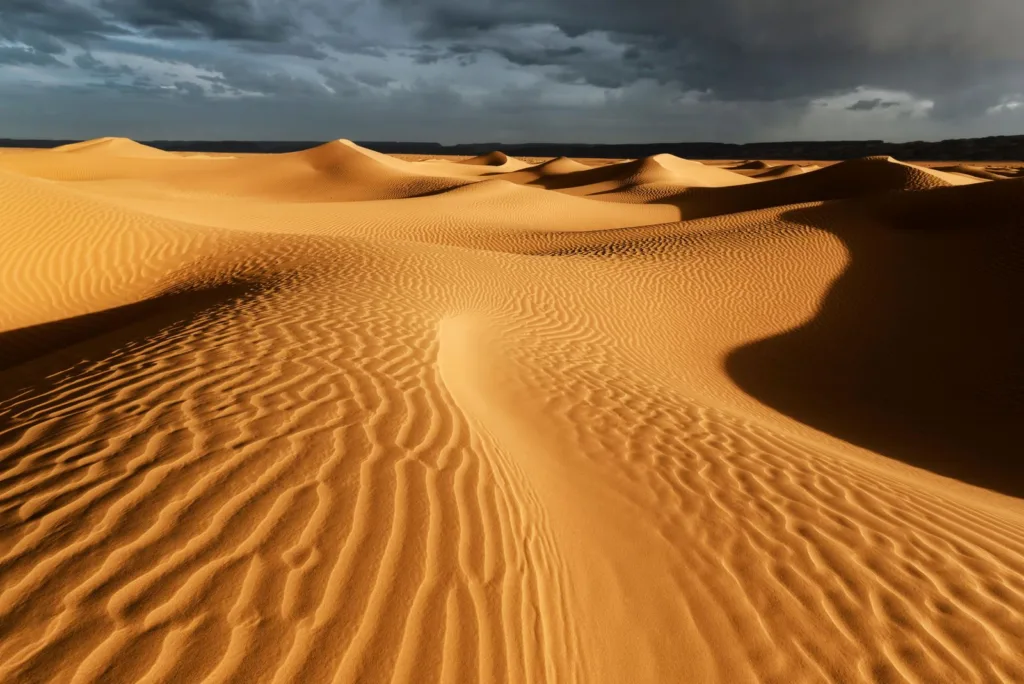
- Deserts: Deserts are arid regions characterized by sparse vegetation and low precipitation. They can be sandy (such as the Sahara Desert), rocky (like the Atacama Desert), or a combination of both. Deserts often feature sand dunes, rock formations, and vast expanses of barren land.
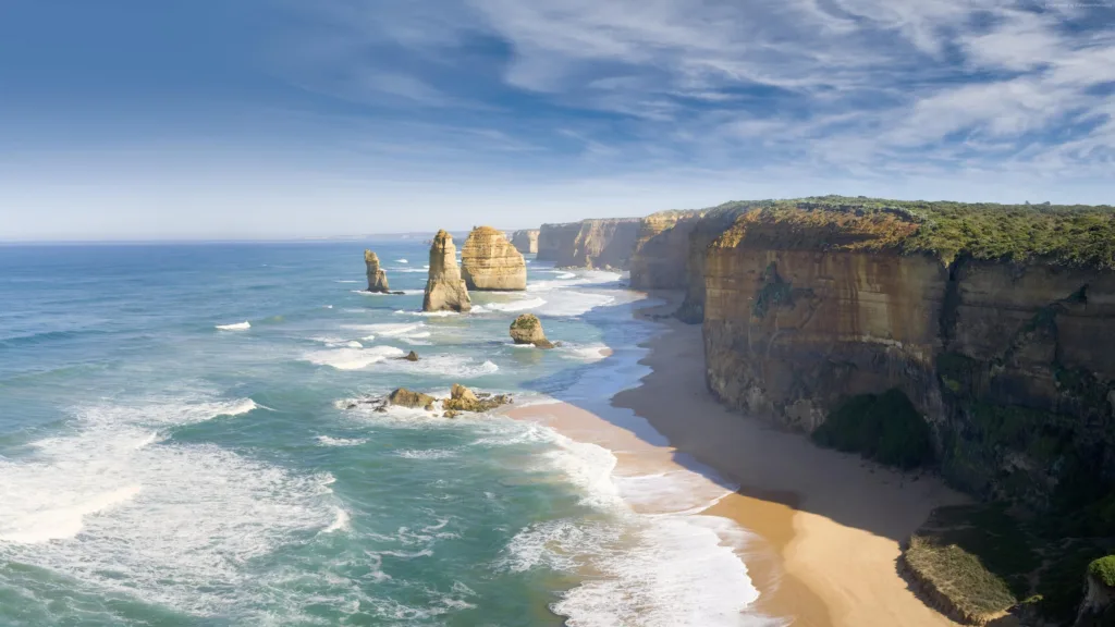
- Coastal Landforms: Coastal landforms are shaped by the interaction of land and sea. They include beaches, cliffs, bays, estuaries, and deltas. Coastal landforms are influenced by processes such as erosion, sediment deposition, wave action, and sea-level changes. Examples include the Great Barrier Reef in Australia and the Cliffs of Moher in Ireland.
- Karst Landscapes: Karst landscapes are characterized by unique features formed by the dissolution of soluble rocks such as limestone or dolomite. They include sinkholes, caves, underground rivers, and limestone pavements. Karst landscapes are often found in regions with abundant rainfall and soluble rock formations. The karst region in Slovenia and the Yucatan Peninsula in Mexico are well-known examples.
- Glacial Landforms: Glacial landforms are formed by the movement and erosion of glaciers. They include features like U-shaped valleys, cirques, moraines, and fjords. Glacial landforms are commonly found in regions that have experienced past glaciation, such as the Alps, the Canadian Rockies, and Antarctica.
These are just a few examples of the diverse landforms that exist on Earth. Each type of landform provides valuable insights into the geological processes that have shaped our planet over millions of years.
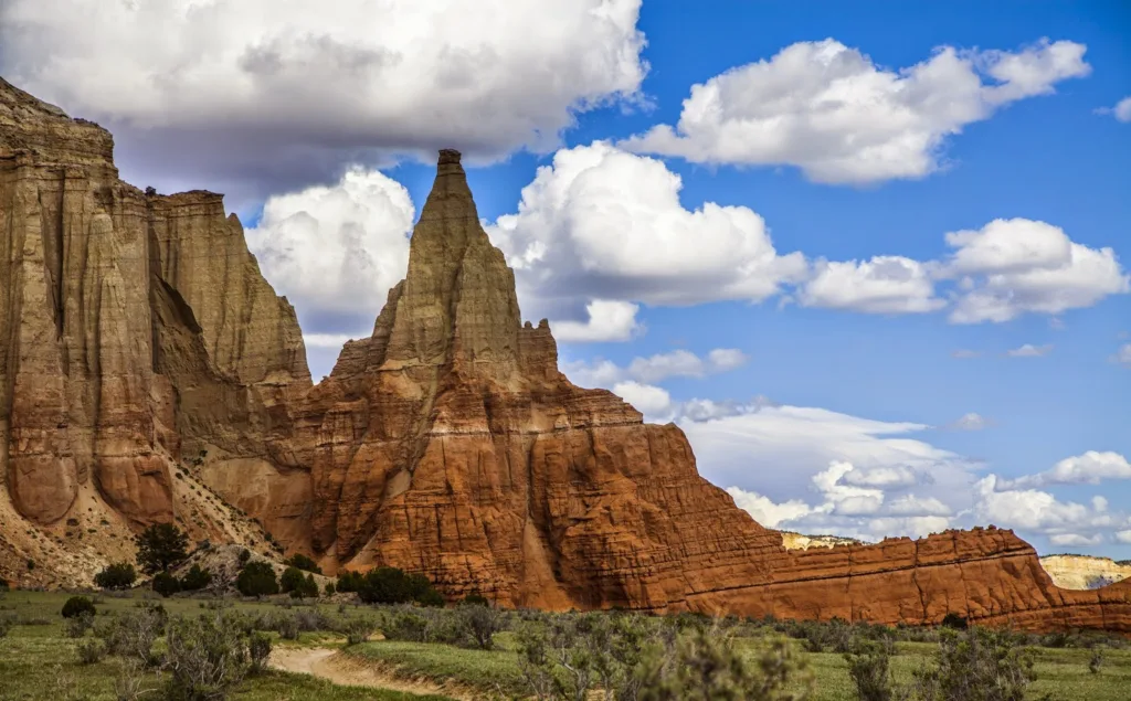
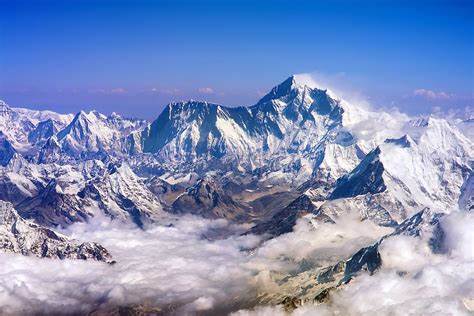
Mountains Formation and characteristics
Mountains are large landforms that rise prominently above the surrounding landscape. They are typically characterized by their considerable height, steep slopes, and rugged terrain. Mountains can be formed through various geological processes and can exhibit different characteristics based on their formation.
Formation
- Folded Mountains: Folded mountains are formed when tectonic forces compress and squeeze the Earth’s crust, causing the rocks to fold and buckle. These mountains often have long ridges and valleys and are associated with convergent plate boundaries. The Appalachian Mountains in North America and the Alps in Europe are examples of folded mountains.
- Fault-Block Mountains: Fault-block mountains are created when large blocks of the Earth’s crust are uplifted or dropped along faults. The uplifted blocks form mountain ranges, while the down-dropped blocks create valleys. The Sierra Nevada in the United States and the Tetons in Wyoming are examples of fault-block mountains.
- Volcanic Mountains: Volcanic mountains form when molten rock (magma) rises to the surface through volcanic activity. As the magma solidifies, it builds up layers of volcanic material, including lava, ash, and pyroclastic deposits. Over time, repeated eruptions can build towering volcanic mountains. Examples of volcanic mountains include Mount Kilimanjaro in Tanzania, Mount Fuji in Japan, and Mount St. Helens in the United States.
Characteristics
- Height and Prominence: Mountains are defined by their significant height above the surrounding terrain. The height of mountains varies widely, from several hundred meters to several kilometers. The prominence of a mountain refers to its vertical rise above the surrounding land.
- Slopes and Peaks: Mountains often have steep slopes, which become steeper toward the summit. The peaks of mountains can be pointed, jagged, or rounded, depending on factors such as erosion and the type of rock that makes up the mountain.
- Rugged Terrain: Mountains are characterized by rugged and challenging terrain. They can feature deep valleys, narrow ridges, sharp cliffs, and rock formations. Glacial activity can carve out U-shaped valleys and leave behind features like cirques and hanging valleys.
Examples of Famous Mountain Ranges:
- Himalayas: The Himalayas, located in Asia, are the highest and most famous mountain range in the world. They span several countries, including India, Nepal, Bhutan, and Tibet. Mount Everest, the tallest peak in the world, is part of the Himalayas.
- Andes: The Andes, running along the western coast of South America, is the longest mountain range in the world. It spans several countries, including Argentina, Chile, Peru, and Colombia. The Andes are known for their high peaks, deep valleys, and diverse ecosystems.
- Rockies: The Rocky Mountains, or the Rockies, stretch across western North America, primarily in the United States and Canada. They are renowned for their stunning landscapes, including majestic peaks, alpine lakes, and dense forests.
- Alps: The Alps are a famous mountain range in Europe, spanning several countries, including France, Switzerland, Italy, Austria, and Germany. They are known for their picturesque beauty, winter sports, and iconic peaks like the Matterhorn.
- Atlas Mountains: The Atlas Mountains stretch across Morocco, Algeria, and Tunisia in North Africa. They are known for their rugged beauty, diverse flora and fauna, and as a habitat for endangered species like the Barbary macaque.
These are just a few examples of famous mountain ranges, but there are numerous other mountain ranges around the world, each with its own unique characteristics and significance.
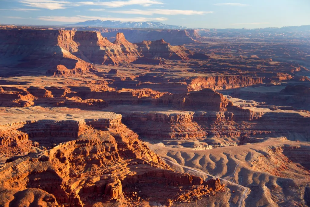
Plateaus Formation and characteristics
Plateaus are elevated flat areas with steep sides. They are distinct landforms that can be formed through various geological processes and exhibit different characteristics based on their formation.
Formation
- Uplifted Plateaus: Uplifted plateaus are formed by tectonic forces that uplift large sections of the Earth’s crust. These plateaus are often associated with the collision of tectonic plates or the gradual uplift of a region over time. The Colorado Plateau in the United States, which includes the Grand Canyon, is an example of an uplifted plateau.
- Volcanic Plateaus: Volcanic plateaus are created through volcanic activity where extensive lava flows cover large areas, resulting in a flat or gently undulating surface. These plateaus are formed by the accumulation of volcanic materials, such as basaltic lava, over time. The Columbia Plateau in the northwestern United States is an example of a volcanic plateau.
- Dissected Plateaus: Dissected plateaus are formed when plateaus are eroded by various agents such as rivers and glaciers. Erosion carves deep valleys, canyons, and gorges into the plateau, creating a highly dissected landscape. The Deccan Plateau in India, which is known for its extensive lava flows and deeply incised valleys, is an example of a dissected plateau.
Characteristics
- Flat or Gently Undulating Surface: Plateaus are characterized by their relatively flat or gently rolling surface on top. While the plateau surface itself is mostly flat, the edges often have steep cliffs or escarpments.
- Steep Sides: Plateaus are bounded by steep slopes or cliffs, which can be the result of tectonic forces or erosion processes that have cut into the plateau edges.
- Extensive Area: Plateaus can cover vast areas, ranging from several square kilometers to thousands of square kilometers.
- Varied Vegetation: Plateaus can support a diverse range of vegetation due to variations in elevation, climate, and soil conditions. Different types of plant communities, such as grasslands, forests, or shrublands, can be found on plateaus.
Notable Examples of Plateaus
- Colorado Plateau: Located in the southwestern United States, the Colorado Plateau is a vast uplifted plateau that covers parts of Colorado, Utah, New Mexico, and Arizona. It is renowned for its dramatic canyons, towering cliffs, and iconic landmarks like the Grand Canyon and Monument Valley.
- Deccan Plateau: Situated in India, the Deccan Plateau is a large volcanic plateau formed by extensive lava flows. It covers a significant portion of southern India and is known for its unique rock formations, ancient cave temples, and rich cultural heritage.
- Tibetan Plateau: Referred to as the “Roof of the World,” the Tibetan Plateau is the highest and largest plateau in the world. Located in Central Asia, it spans Tibet, parts of China, India, Nepal, and Bhutan. The Tibetan Plateau is renowned for its high altitude, vast grasslands, and unique wildlife.
- Altiplano: The Altiplano is a high plateau situated in the Andes Mountains of South America, spanning parts of Bolivia, Peru, Chile, and Argentina. It is one of the highest inhabited plateaus globally, known for its stunning landscapes, salt flats (such as the Uyuni Salt Flat), and traditional cultures.
These are just a few notable examples of plateaus, but there are many other plateaus worldwide that exhibit diverse features and geological histories.
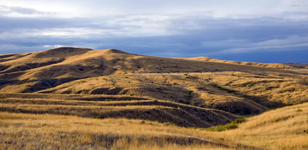
Plains Formation and characteristics
Plains are vast, low-lying areas characterized by relatively flat or gently rolling landscapes. They are formed through various geological processes and can exhibit different characteristics based on their formation.
Formation
- Coastal Plains: Coastal plains are formed along coastlines through the accumulation of sediments deposited by rivers, ocean currents, and waves. Over time, these sediments build up, creating flat or gently sloping plains. Coastal plains can vary in width and are often found adjacent to the sea. The Atlantic Coastal Plain in the United States and the Ganges-Brahmaputra Delta in Bangladesh and India are examples of coastal plains.
- Alluvial Plains: Alluvial plains are formed by the deposition of sediments carried by rivers. These sediments, consisting of eroded materials like sand, silt, and clay, settle and accumulate in the floodplains and deltas of rivers. Alluvial plains are typically fertile and ideal for agriculture. The Indo-Gangetic Plain in South Asia and the Nile Delta in Egypt are examples of alluvial plains.
- Glacial Plains: Glacial plains are formed by the action of glaciers as they move and erode the landscape. When glaciers retreat, they leave behind flat or gently undulating areas covered with glacial deposits, including till, clay, sand, and gravel. Glacial plains are often marked by features such as drumlins, eskers, and moraines. The Great Plains in North America and the North German Plain are examples of glacial plains.
Characteristics
- Flat or Gently Rolling Terrain: Plains are characterized by their relatively flat or gently undulating topography. They lack significant variations in elevation compared to mountains or plateaus.
- Low Relief: Plains have low relief, meaning the difference in elevation between the highest and lowest points is minimal. The slopes of plains are generally gentle.
- Fertile Soils: Plains often have fertile soils due to the accumulation of sediments brought by rivers or glacial activity. These fertile soils make plains suitable for agriculture, supporting extensive agricultural practices.
- Water Availability: Plains are often well-watered due to the presence of rivers and lakes. They are conducive to the development of river valleys, floodplains, and wetlands.
Types of Plains
- Coastal Plains: Formed by the deposition of sediments along coastlines.
- Alluvial Plains: Created by the deposition of sediments carried by rivers.
- Glacial Plains: Resulting from the deposition of glacial sediments by retreating glaciers.
Famous Plains around the World
- Indo-Gangetic Plain: Located in South Asia, the Indo-Gangetic Plain is one of the most extensive and fertile alluvial plains in the world. It covers a significant part of northern India, Pakistan, and Bangladesh and is known for its intensive agricultural practices and densely populated cities.
- Great Plains: The Great Plains of North America span several countries, including the United States and Canada. This vast region is characterized by grasslands, agricultural activities, and unique features like the Badlands National Park and the Black Hills.
- Pampas: The Pampas is a fertile plain located in South America, primarily in Argentina and Uruguay. It is known for its expansive grasslands, agricultural production (especially cattle ranching), and unique flora and fauna.
- Siberian Plain: The Siberian Plain is a massive plain that covers a significant portion of Russia. It is one of the largest flat regions in the world and features a variety of landscapes, including tundra, forests, and wetlands.
Valleys Formation and characteristics
Valleys are low-lying areas located between mountains or hills. They are often formed through the erosive action of rivers, glaciers, or tectonic processes. Valleys can exhibit different characteristics based on their formation and the processes involved.
Formation
- Fluvial Valleys: Fluvial valleys are formed by the erosive action of rivers over time. Rivers carve through the land, cutting deep channels and creating valleys. The flow of water erodes the rock and sediment, shaping the valley’s characteristic features. Fluvial valleys are commonly found in mountainous regions and are often characterized by V-shaped profiles. The Grand Canyon in the United States and the Yarlung Tsangpo Valley in Tibet are examples of fluvial valleys.
- Glacial Valleys: Glacial valleys are formed by the movement and erosion of glaciers. As glaciers advance and retreat, they carve out U-shaped valleys. Glacial erosion is characterized by the removal of large amounts of material, resulting in broad and flat valley floors with steep sides. Examples of glacial valleys include Yosemite Valley in the United States and Lauterbrunnen Valley in Switzerland.
- Rift Valleys: Rift valleys are created by tectonic processes, particularly the stretching and splitting of the Earth’s crust. As the crust pulls apart, it creates a depression that forms a long, narrow valley. Rift valleys can be found along divergent plate boundaries and are characterized by steep walls and flat bottoms. The East African Rift Valley, including the Great Rift Valley, is one of the most well-known examples of rift valleys.
Characteristics
- Shape: Valleys can have different shapes depending on the processes involved in their formation. V-shaped valleys have steep sides and a narrow bottom, while U-shaped valleys have a broader and flatter floor with steep sides. Rift valleys are long and narrow with steep walls.
- Drainage: Valleys often serve as channels for water drainage, with rivers or streams flowing through them. They collect water from surrounding areas and may contain rivers, creeks, or lakes.
- Steepness: Valleys can have varying degrees of slope steepness, ranging from gentle slopes to steep cliffs, depending on the erosional forces involved.
Well-Known Valleys Worldwide
- Napa Valley: Located in California, United States, Napa Valley is renowned for its vineyards and wineries. It is a picturesque valley known for its scenic beauty, rolling hills, and wine production.
- Kathmandu Valley: Situated in Nepal, the Kathmandu Valley is a UNESCO World Heritage Site and the cultural heart of the country. It is home to the capital city of Kathmandu and encompasses a series of historic towns, ancient temples, and picturesque landscapes.
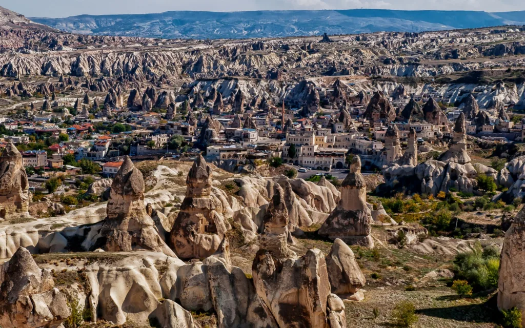
- Cappadocia Valleys: Located in Turkey, the Cappadocia region is famous for its unique rock formations, known as fairy chimneys. The valleys in Cappadocia, such as the Love Valley and Rose Valley, offer stunning landscapes with bizarre rock formations and ancient cave dwellings.
- Wadi Rum: Located in Jordan, Wadi Rum is a desert valley known for its dramatic sandstone and granite rock formations. It is a popular destination for adventure tourism and offers breathtaking desert scenery.
- Yosemite Valley: Situated in Yosemite National Park in California, United States, Yosemite Valley is renowned for its awe-inspiring granite cliffs, towering waterfalls, and lush meadows. It is a UNESCO World Heritage Site and attracts millions of visitors each year.
These are just a few examples of well-known valleys worldwide. Valleys can be found in various countries and regions, each with its own unique features and significance.
Deserts Formation and characteristics
Deserts are vast, arid regions characterized by minimal precipitation and sparse vegetation. They cover a significant portion of the Earth’s surface and can be found across different continents. Deserts are formed through various geological and climatic processes and can exhibit different characteristics based on their formation and location.
Formation
- Rain Shadow Deserts: Rain shadow deserts are formed when moist air from an ocean or large body of water rises over a mountain range, causing precipitation on the windward side. As the air descends on the leeward side, it becomes drier and creates arid conditions, resulting in the formation of a desert. Examples include the Mojave Desert in the United States and the Atacama Desert in Chile.
- Subtropical Deserts: Subtropical deserts are located in the vicinity of the tropics, typically between 15 to 30 degrees latitude. They are formed by the global atmospheric circulation patterns that create high-pressure zones, resulting in stable, dry air and limited rainfall. The Sahara Desert in Africa and the Arabian Desert in the Middle East are examples of subtropical deserts.
- Coastal Deserts: Coastal deserts are situated along the western coastlines of continents, where cold ocean currents cause cool, dry air to prevail. These deserts are influenced by the cool oceanic conditions, which inhibit the formation of clouds and result in limited rainfall. The Namib Desert in Namibia and the Atacama Desert in Chile are examples of coastal deserts.
Characteristics
- Aridity: Deserts are characterized by extremely low precipitation, often receiving less than 250 millimeters (10 inches) of rainfall annually. This arid environment creates dry and barren landscapes.
- Sparse Vegetation: Due to the scarcity of water, deserts typically have sparse vegetation, consisting mainly of drought-resistant plants such as cacti, succulents, and shrubs. Some desert regions may have areas of sand dunes or rocky terrain.
- Temperature Extremes: Deserts often experience temperature extremes, with scorching hot days and cool nights. During the day, desert temperatures can reach extremely high levels, while at night, heat rapidly dissipates, causing significant drops in temperature.
Types of Deserts
- Hot Deserts: Hot deserts, such as the Sahara Desert, are characterized by high temperatures throughout the year. They often have a subtropical or tropical climate and limited vegetation cover.
- Cold Deserts: Cold deserts, such as the Gobi Desert in Mongolia, experience extremely cold temperatures in winter and relatively cool temperatures in summer. These deserts are usually found at higher latitudes or at high elevations.
- Coastal Deserts: Coastal deserts, such as the Namib Desert, are influenced by cool oceanic conditions. They experience cool to mild temperatures and have a unique blend of coastal and desert landscapes.
Prominent Deserts across Different Continents
- Sahara Desert: Located in North Africa, the Sahara Desert is the largest hot desert in the world, covering an area of about 9.2 million square kilometers (3.6 million square miles).
- Gobi Desert: Situated in East Asia, the Gobi Desert spans parts of northern China and southern Mongolia. It is the largest cold desert in the world and is known for its vast stretches of arid and barren landscapes.
- Atacama Desert: Found in South America along the western coast of Chile and parts of Peru, the Atacama Desert is known as the driest non-polar desert on Earth. It is a coastal desert characterized by its aridity and unique geological features.
Rivers and Water Bodies Formation and characteristics
Rivers and water bodies play a crucial role in shaping the Earth’s landscape and supporting various ecosystems. They are formed through the accumulation of water from various sources and exhibit different characteristics based on their formation and the processes involved.
Formation and Characteristics: Rivers
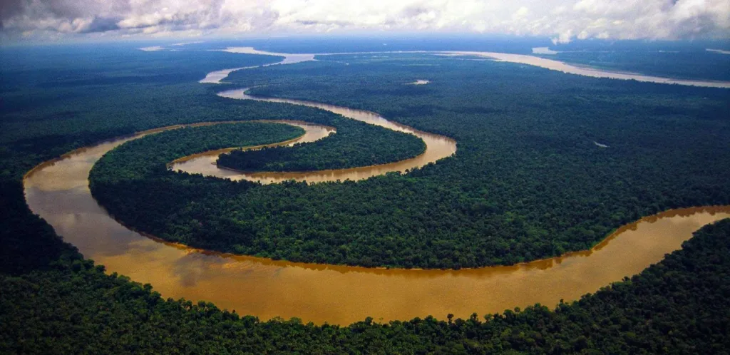
- River Formation: Rivers are formed by the accumulation of water from various sources such as rainfall, melting snow and ice, and underground springs. These water sources gather and flow downhill, carving channels and creating river systems.
- Channel Characteristics: Rivers typically have a main channel that meanders through the landscape, with tributaries joining along the way. They vary in size, width, and depth, influenced by factors such as the volume of water, gradient, and sediment load. Rivers are dynamic and constantly shape their channels through erosion and deposition processes.
- Erosion and Deposition: Rivers play a vital role in eroding and transporting sediments. They carry rocks, sand, silt, and clay downstream, gradually reshaping the land. The erosive power of rivers can carve valleys and canyons over time. When rivers slow down and deposit their sediment load, they can form deltas, floodplains, and alluvial fans.
Water Bodies
- Lakes: Lakes are large bodies of water that are often formed through various geological processes, including tectonic activity, glacial action, volcanic activity, and river damming. Lakes can vary in size, depth, and water chemistry. They serve as important habitats for aquatic plants and animals.
- Oceans: Oceans are vast bodies of saltwater that cover about 71% of the Earth’s surface. They are formed due to tectonic plate movements, where large areas of the Earth’s crust are submerged. Oceans have significant influence on climate, weather patterns, and the distribution of life forms. The Pacific Ocean, Atlantic Ocean, Indian Ocean, Southern Ocean, and Arctic Ocean are the major oceans of the world.
Types of Rivers
- Meandering Rivers: Meandering rivers have a sinuous, winding pattern. They often occur in flatter terrain and exhibit gentle curves called meanders. Meandering rivers erode the outer banks of the bends and deposit sediment on the inner banks.
- Braided Rivers: Braided rivers have multiple interconnected channels that split and rejoin, creating a braided appearance. They typically occur in areas with a high sediment load and variable flow rates, such as glacial regions or arid environments.
- Delta Rivers: Delta rivers are characterized by their wide, fan-shaped mouths where the river meets a body of water, such as a sea or lake. Deltas are formed when rivers carry sediment that is deposited as the flow slows down, creating landforms with rich soils.
Major Rivers and Water Bodies Worldwide
- Amazon River: The Amazon River in South America is the largest river in terms of discharge and one of the longest rivers in the world. It flows through several countries, including Peru, Colombia, and Brazil, and is known for its vast rainforest, diverse ecosystems, and biodiversity.
- Nile River: The Nile River is the longest river globally, flowing through eleven countries in northeastern Africa. It is culturally and historically significant, providing water for agriculture and supporting ancient civilizations such as Ancient Egypt.
- Yangtze River: The Yangtze River in China is the longest river in Asia and the third longest in the world. It plays a crucial role in China’s economy and culture, supporting agriculture, hydropower generation, and transportation.
- Mississippi River: The Mississippi River is one of the major rivers in North America, flowing through the United States. It is an important transportation route and has a significant impact on the country’s economy and ecology.
- Lake Baikal: Lake Baikal in Siberia, Russia, is the deepest and oldest freshwater lake in the world. It is known for its exceptional biodiversity and is considered a UNESCO World Heritage Site.
- Great Barrier Reef: The Great Barrier Reef in Australia is the world’s largest coral reef system, stretching over 2,300 kilometers (1,400 miles). It is home to a wide range of marine species and is a popular tourist destination.
These are just a few examples of major rivers and water bodies worldwide. Rivers and water bodies can be found on every continent, contributing to the beauty, ecological balance, and human activities on our planet.
Coastlines Formation and characteristics
Coastlines refer to the boundary between land and the ocean or sea. They are dynamic and diverse environments shaped by various geological processes, including erosion, deposition, and tectonic activity. Coastlines can exhibit different characteristics based on their formation, geological composition, and interaction with water and weather.
Formation and Characteristics
- Erosional Processes: Coastlines are subjected to erosional forces such as waves, tides, and currents. These processes can erode the land, shaping the coastline and creating distinct features such as cliffs, sea caves, and sea stacks.
- Depositional Processes: Sediments carried by rivers, waves, and currents are deposited along coastlines, forming beaches, sandbars, and barrier islands. Depositional processes also contribute to the formation of estuaries and deltas.
- Tides and Waves: Tides, caused by gravitational forces between the Earth, moon, and sun, play a significant role in shaping coastlines. Waves generated by wind energy continuously reshape and modify coastlines, eroding some areas and depositing sediment in others.
Types of Coastlines
- Rocky Coastlines: Rocky coastlines are characterized by rugged cliffs, rocky shores, and sea stacks. These coastlines often occur in areas with hard rock formations that are resistant to erosion. Rocky coastlines can be found in regions with high wave energy, such as along exposed shorelines.
- Sandy Coastlines: Sandy coastlines are characterized by extensive stretches of sandy beaches. They are formed through the accumulation of sand and other sediments, often carried by rivers and deposited along the coast. Sandy coastlines are more common in areas with low wave energy and abundant sediment supply.
- Estuaries: Estuaries are partially enclosed coastal bodies of water where rivers meet the sea. They are characterized by brackish water, influenced by both freshwater and saltwater. Estuaries are important ecological habitats and serve as nurseries for many marine species.
Notable Coastlines and Coastal Features
- The Great Ocean Road, Australia: The Great Ocean Road in Australia is famous for its stunning coastal scenery, including the Twelve Apostles rock formations. This iconic stretch of coastline showcases rugged cliffs, picturesque beaches, and unique geological formations.
- The Amalfi Coast, Italy: The Amalfi Coast in Italy is renowned for its dramatic and picturesque coastline along the Mediterranean Sea. It features colorful cliffside villages, terraced vineyards, and steep limestone cliffs.
- The Big Sur Coastline, California, USA: The Big Sur coastline in California offers breathtaking views of the Pacific Ocean. It is known for its rugged cliffs, pristine beaches, and scenic coastal drive along the Pacific Coast Highway.
- The Norwegian Fjords: The Norwegian coastline is famous for its fjords, deep and narrow coastal inlets carved by glaciers. These fjords, such as Geirangerfjord and Nærøyfjord, offer majestic landscapes with steep cliffs, cascading waterfalls, and crystal-clear waters.
- The Halong Bay, Vietnam: Halong Bay is a UNESCO World Heritage Site known for its unique limestone karsts and islands rising from the emerald waters of the Gulf of Tonkin. It is a popular tourist destination, showcasing a spectacular coastal landscape.
These are just a few examples of notable coastlines and coastal features around the world. Coastlines offer diverse natural beauty, recreational opportunities, and support unique ecosystems that are important for both human and marine life.
Caves and Karst Landforms
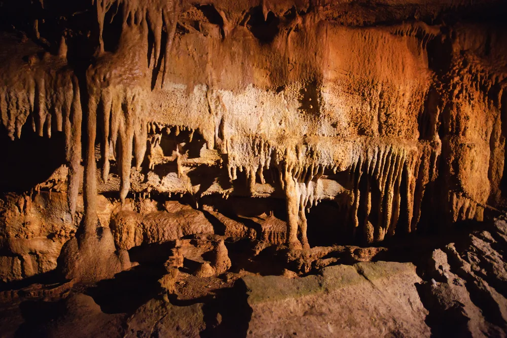
Caves and karst landforms are unique geological features that are formed in soluble rocks such as limestone, dolomite, and gypsum. They are characterized by underground cavities and intricate formations created through various erosional processes. Let’s explore their formation, characteristics, types of features, and some famous examples.
Formation and Characteristics: Caves and karst landforms are typically formed through the process of karstification, which involves the dissolution of soluble rocks by water. The dissolution occurs when water, often acidic, reacts with the minerals in the rock, gradually creating underground cavities and passages.
Characteristics of Caves:
- Caverns: Caves are underground voids and chambers that can range in size from small, narrow passages to vast caverns. They often feature unique geological formations and are usually accessed through openings on the surface.
- Stalactites and Stalagmites: Stalactites and stalagmites are common cave formations. Stalactites hang from the cave ceiling and are formed by the gradual deposition of minerals carried by water dripping from above. Stalagmites rise from the cave floor as a result of minerals precipitating out of water dripping onto the ground. Over time, these formations can grow and meet, creating columns.
- Speleothems: Speleothems are various mineral deposits that form within caves, including flowstones, draperies, and helictites. These formations add to the unique beauty of caves and can take on diverse shapes and colors.
Characteristics of Karst Landforms:
- Sinkholes: Sinkholes are depressions or holes that form when the roof of an underground cave collapses, revealing a surface opening. Sinkholes can vary in size from small to large and can be hazardous to human settlements.
- Karst Springs: Karst springs are where underground water emerges onto the surface, often forming picturesque streams or pools. These springs are an important source of water in karst regions.
- Poljes: Poljes are large, flat-bottomed depressions found in karst landscapes. They are typically formed by the collapse of underground caverns or the dissolution of soluble rock layers.
Types of Caves and Karst Features:
- Solutional Caves: Solutional caves are formed primarily through the dissolution of soluble rock. These caves are often characterized by complex networks of passages and can contain stunning formations.
- Lava Tubes: Lava tubes are caves that form when flowing lava solidifies on the surface, leaving behind a hollow tube. These caves are commonly found in volcanic regions and can have unique geological features.
- Sea Caves: Sea caves are formed through wave erosion along coastlines. They often have entrances facing the sea and can extend deep into cliffs or headlands.
Famous Cave Systems and Karst Landscapes:
- Mammoth Cave System, Kentucky, USA: Mammoth Cave is the longest known cave system in the world, with over 650 kilometers (400 miles) of explored passages. It features a diverse range of speleothems and is a designated UNESCO World Heritage Site.
- Škocjan Caves, Slovenia: The Škocjan Caves are a UNESCO World Heritage Site and one of the largest underground canyons in the world. The cave system features stunning underground chambers, a river, and a unique natural bridge.
- Hang Son Doong, Vietnam: Hang Son Doong is the largest known cave in the world, located in Phong Nha-Ke Bang National Park. It boasts massive caverns, towering stalagmites, and an underground river.
- Waitomo Glowworm Caves, New Zealand: The Waitomo Glowworm Caves are famous for their unique glowworm species, Arachnocampa luminosa. These bioluminescent creatures light up the dark caves, creating a magical spectacle.
- The Puerto Princesa Subterranean River, Philippines: The Puerto Princesa Subterranean River is a UNESCO World Heritage Site and one of the longest navigable underground rivers in the world. It flows through a dramatic limestone cave system, surrounded by lush vegetation.
These are just a few examples of famous cave systems and karst landscapes. Caves and karst landforms offer captivating geological formations and provide valuable insights into the Earth’s history and underground ecosystems.
FAQs
What are landforms?
Landforms are natural features that make up the Earth’s surface. They include mountains, valleys, plains, plateaus, deserts, rivers, lakes, and coastlines.
How are landforms formed?
Landforms are formed through various geological processes, including erosion, deposition, tectonic activity, volcanic activity, weathering, and the actions of water, wind, and ice.
What is the difference between a mountain and a hill?
Mountains are taller and steeper landforms compared to hills. They often have rugged terrain, higher elevations, and are formed through tectonic forces or volcanic activity. Hills, on the other hand, are smaller and have gentler slopes.
What are the main types of rivers?
The main types of rivers include meandering rivers (with sinuous curves), braided rivers (with interconnected channels), and delta rivers (which deposit sediment at their mouths).
How are plateaus formed?
Plateaus are elevated flat or gently rolling landforms. They can be formed through processes like uplift, volcanic activity, or erosion, where surrounding areas erode faster, leaving behind a relatively flat elevated surface.
What are coastal features?
Coastal features refer to the various landforms found along coastlines, such as cliffs, beaches, sea stacks, sand dunes, estuaries, and coral reefs. These features are shaped by the interaction of land, sea, and geological processes.
How are caves formed?
Caves are formed through the dissolution of soluble rocks (like limestone) by water over long periods. Water seeps into cracks and joints, slowly enlarging them to create underground cavities.
What is karst topography?
Karst topography refers to landscapes formed by the dissolution of soluble rocks, such as limestone or dolomite. It is characterized by features like sinkholes, caves, disappearing streams, and underground drainage systems.
How are deserts formed?
Deserts are formed in regions where there is limited rainfall and high rates of evaporation, resulting in arid conditions. They can be classified as hot deserts (like the Sahara) or cold deserts (like the Gobi), depending on their geographical location.
What are the main types of plains?
The main types of plains include coastal plains (formed by sediment deposition along coastlines), alluvial plains (formed by rivers and floodplains), and glacial plains (formed by glacial action and deposition of sediment).

")


