












Home Blog Page 71

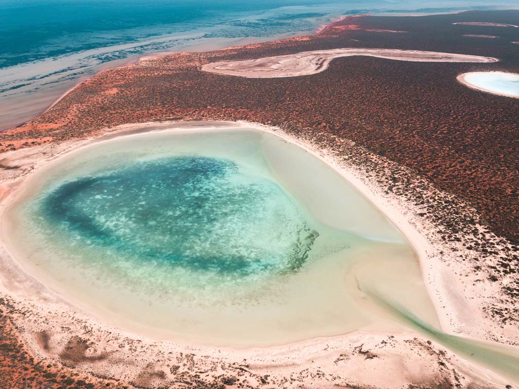
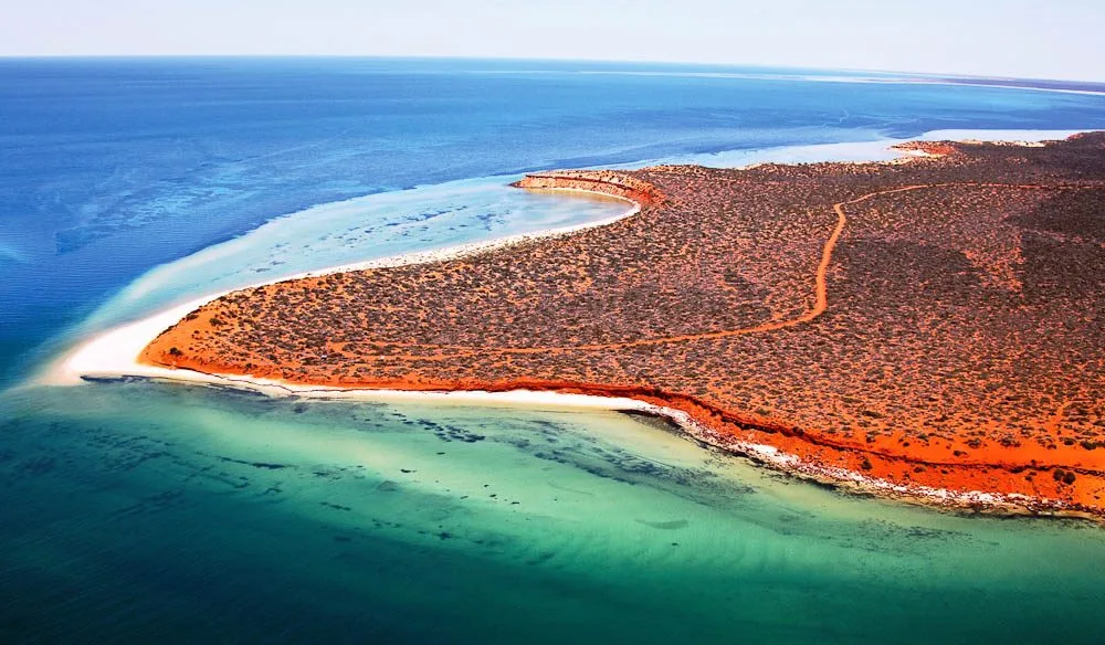
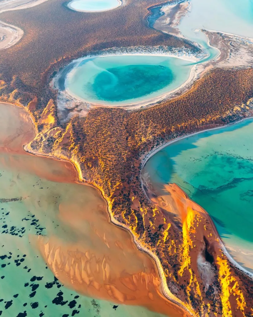
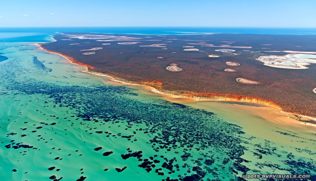
Shark Bay, Australia
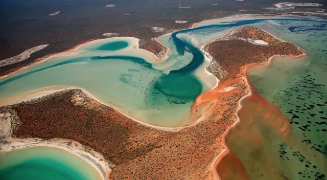
Shark Bay is a unique and diverse World Heritage Site located on the western coast of Australia. It is known for its remarkable geological features, including stromatolites, saline flats, and stunning coastline. The geology of Shark Bay tells a story that spans millions of years and provides insights into the region’s geological history and formation.
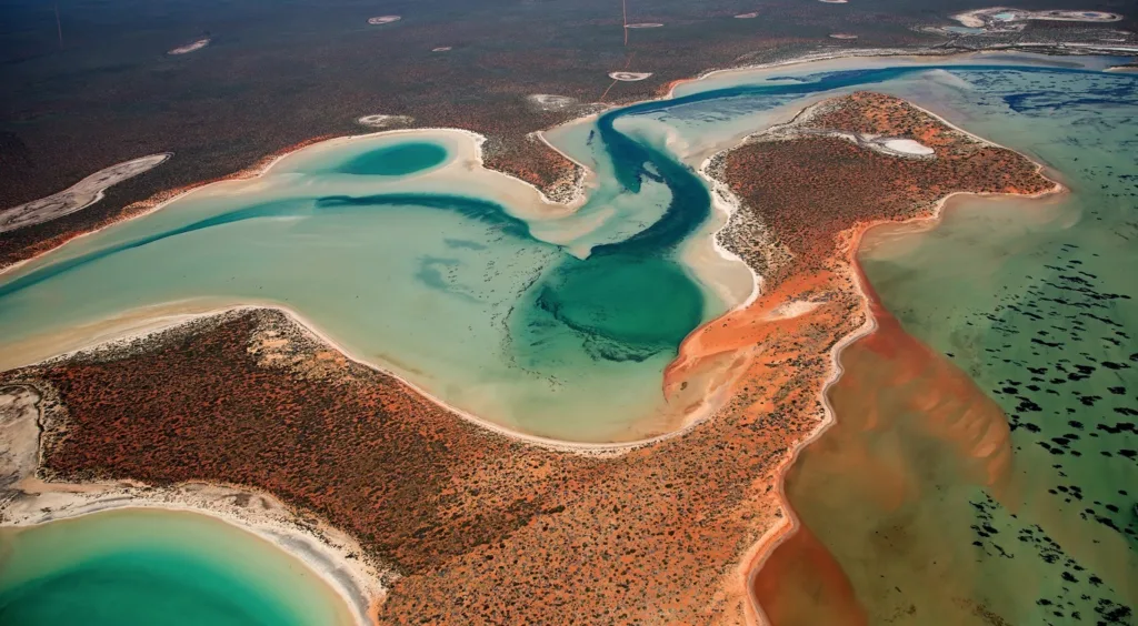
The geological history of Shark Bay dates back to the Precambrian era, around 3.5 billion years ago. At that time, the region was a part of an ancient continental landmass. Over time, geological processes such as tectonic activity, erosion, and sedimentation shaped the area into what it is today.

One of the most significant geological events in Shark Bay’s history occurred during the Proterozoic era, around 2.4 billion years ago. It was during this time that microbial life, particularly cyanobacteria, began to flourish in the shallow marine environments of Shark Bay. These organisms played a crucial role in forming stromatolites, which are layered sedimentary structures created by the trapping and binding of sediment by microbial communities. Shark Bay is home to some of the world’s oldest and largest living stromatolites, providing valuable insights into the early history of life on Earth.

During the Paleozoic era, around 540 million years ago, Shark Bay was submerged under a shallow sea. The sediments deposited during this time eventually formed the Hamelin Pool Formation, which is rich in stromatolites and microbial mats.

As the geological timeline progressed into the Mesozoic era, around 250 million years ago, the supercontinent Pangaea began to break apart. This tectonic activity resulted in the separation of the Australian and Indian plates and the formation of the Indian Ocean. The coastline of Shark Bay was shaped by the rising and falling sea levels during this period, leaving behind ancient dune systems and sandstone cliffs.

In more recent times, during the Cenozoic era, around 66 million years ago, the sea levels fluctuated, and Shark Bay experienced periods of marine transgression and regression. The accumulation of sediments and the subsequent erosion shaped the diverse landscapes seen today, including the breathtaking Zuytdorp Cliffs and the Wooramel Seismic Zone.

The Shark Bay region also displays evidence of past climatic changes and geological phenomena. For instance, the presence of saline flats and hypersaline marine environments indicates a history of evaporative processes and the formation of salt deposits.

In conclusion, the geological history and formation of Shark Bay span billions of years, showcasing a rich and dynamic past. From ancient microbial communities that shaped stromatolites to tectonic activity and changing sea levels, the geology of Shark Bay offers a fascinating glimpse into the Earth’s geological evolution and the development of life.

Geological Features and Landforms

Shark Bay in Western Australia is renowned for its diverse and captivating geological features and landforms. Here, I will describe some of the major landforms found in Shark Bay, both along the coastline and inland.

Coastal Features:

  1. Beaches: Shark Bay boasts several beautiful sandy beaches, including Monkey Mia Beach, Shell Beach, and Herald Bight. These beaches are characterized by their pristine white sands and turquoise waters, offering visitors a picturesque coastal experience.
  2. Cliffs: The Zuytdorp Cliffs, located in the northern part of Shark Bay, are an impressive coastal feature. Rising up to 170 meters (550 feet) above sea level, these ancient limestone cliffs provide stunning panoramic views of the Indian Ocean.
  3. Dunes: Extensive sand dune systems can be found along the coast of Shark Bay. These dunes were formed by wind and wave action over millions of years. Some notable dune systems include the Francois Peron National Park and the Peron Heritage Precinct, where visitors can witness the unique flora and fauna adapted to the sandy environments.

Inland Features:

  1. Salt Pans: Shark Bay is home to expansive salt flats or pans, such as the Hamelin Pool and Useless Loop. These areas were formed through a combination of evaporation and sedimentation processes over thousands of years. The salt pans create a striking white landscape and provide habitat for unique organisms, including the famous stromatolites.
  2. Stromatolite Formations: Shark Bay is globally recognized for its living stromatolites, which are microbial mat structures formed by cyanobacteria. These structures can be observed at Hamelin Pool, where they thrive in the hypersaline conditions. Stromatolites offer valuable insights into the early history of life on Earth.
  3. Limestone Structures: Limestone is a prevalent rock type in Shark Bay, and it has given rise to various fascinating formations. One notable limestone feature is the “Pinnacles Desert” located in Nambung National Park, just outside the Shark Bay area. The Pinnacles are tall, limestone pillars rising from the sandy desert floor, creating a surreal and otherworldly landscape.
  4. Fossil Shell Banks: Shell Beach, located near the town of Denham, is an exceptional landform made up entirely of shells. It stretches for approximately 110 kilometers (68 miles) and consists of billions of tiny shells of the cockle species. The shells accumulated over thousands of years and created a unique and remarkable coastline.

These are just a few examples of the diverse geological features and landforms that can be found in Shark Bay. From stunning beaches and cliffs to salt pans, stromatolite formations, and limestone structures, the region offers a captivating blend of natural wonders and geological history.

Coastal Processes and Land Evolution

Coastal processes play a significant role in shaping the landforms and land evolution in Shark Bay. Here’s an overview of coastal erosion and deposition processes, the impact of tides, waves, and currents, as well as the influence of longshore drift on shoreline changes.

  1. Coastal Erosion and Deposition: Coastal erosion is the wearing away of land along the shoreline, while deposition refers to the accumulation of sediments. In Shark Bay, erosion and deposition occur due to various factors, including wave action, wind, and tidal forces.

Wave erosion: Powerful ocean waves, especially during storms, can erode the shoreline by removing sediments and wearing down cliffs or coastal bluffs. This erosion contributes to the formation of sea caves, notches, and platforms along the coast.

Wind erosion: Wind can transport loose sand and sediment from beaches and dunes, leading to the formation of sandbars and dune migration.

Deposition: Sediments carried by rivers and currents can be deposited along the coast, contributing to the formation of beaches, sandbars, and barrier islands.

  1. Impact of Tides, Waves, and Currents: Tides: Shark Bay experiences semi-diurnal tides, with two high tides and two low tides occurring each day. Tidal forces influence the movement of water, leading to erosion and deposition processes. During high tides, coastal erosion may occur as waves reach farther inland, while during low tides, deposition may take place as sediments settle.

Waves: Waves generated by wind are a primary force shaping Shark Bay’s coastline. Their energy can erode the shoreline, particularly where cliffs or bluffs are present. The intensity and direction of wave action influence the rate of erosion and deposition along the coast.

Currents: Longshore currents, driven by waves approaching the shoreline at an angle, play a crucial role in coastal processes. These currents transport sediments along the coast, resulting in the phenomenon known as longshore drift.

  1. Longshore Drift and Shoreline Changes: Longshore drift is the process by which sediments are transported along the coastline due to the oblique approach of waves. As waves strike the shoreline at an angle, they carry sediments in a zigzag pattern along the coast. This movement of sediments contributes to both erosion and deposition processes.

Longshore drift can lead to the formation of spits, sandbars, and barrier islands as sediments accumulate. However, it can also cause changes to the shoreline over time. For example, if there is a dominant longshore drift in one direction, sediments may be carried away from an area, leading to erosion. Conversely, deposition can occur in areas where sediments accumulate due to changes in wave direction or the presence of barriers.

Overall, the combined effects of tides, waves, currents, and longshore drift play a significant role in shaping the landforms and influencing the evolution of Shark Bay’s coastal areas. It is an ongoing process that results in both erosion and deposition, contributing to the dynamic nature of the region’s shoreline.

Sedimentary Deposits and Geological Formations

Shark Bay in Western Australia is characterized by a diverse range of sedimentary deposits and geological formations. Here’s an overview of the sedimentary deposits in Shark Bay, as well as the formation of sand dunes, sandbars, beach ridges, and key geological formations like the Tamala Limestone and Zuytdorp Cliffs.

  1. Sedimentary Deposits: Shark Bay has a rich accumulation of sedimentary deposits resulting from various geological processes. These deposits include:
  • Sand: The region is known for its extensive sand dune systems, which are primarily composed of quartz sand. Wind-driven processes transport and deposit sand particles, shaping the dune formations.
  • Mud and Clay: Sediments rich in mud and clay can be found in the sheltered areas of Shark Bay, such as shallow embayments and estuaries. These sediments are often associated with calm water conditions and the deposition of fine particles.
  • Shell Deposits: Shell fragments and accumulations can be observed in areas like Shell Beach, where billions of tiny cockle shells have formed a distinct landform. Shell deposits also contribute to the overall sedimentary composition of Shark Bay.
  1. Sand Dunes, Sandbars, and Beach Ridges: Shark Bay’s coastal areas exhibit dynamic formations influenced by wind and wave action:
  • Sand Dunes: The dune systems in Shark Bay are formed through the accumulation of wind-blown sand. Prevailing winds carry sand particles from the beach and deposit them inland, resulting in the development of dunes with characteristic shapes and sizes. These dunes play a crucial role in stabilizing the coastline and protecting the land from erosion.
  • Sandbars: Sandbars are submerged or partially exposed ridges of sand that form parallel to the coastline. They are typically created by longshore drift, with waves carrying and depositing sediments in offshore areas. Sandbars can influence wave action and contribute to the formation of barrier islands and lagoons.
  • Beach Ridges: Beach ridges are formed by the continuous deposition of sediments along the shoreline. Over time, multiple ridges can develop, reflecting changes in sea level and wave patterns. These ridges are often composed of sand and shell fragments and can be observed in Shark Bay’s coastal areas.
  1. Geological Formations: Two notable geological formations in Shark Bay are the Tamala Limestone and Zuytdorp Cliffs:
  • Tamala Limestone: The Tamala Limestone is a prominent geological formation found along the coastline of Shark Bay. It consists of ancient limestone deposits that were formed in shallow marine environments. The Tamala Limestone is characterized by its porous nature and distinctive white color, contributing to the stunning coastal landscapes in the region.
  • Zuytdorp Cliffs: The Zuytdorp Cliffs are towering limestone cliffs located in the northern part of Shark Bay. These cliffs rise up to 170 meters (550 feet) above sea level and extend for several kilometers. The Zuytdorp Cliffs were formed through the accumulation of marine sediments and subsequent geological processes over millions of years. They offer breathtaking views of the Indian Ocean and provide valuable insights into the geological history of the area.

These sedimentary deposits and geological formations in Shark Bay contribute to the unique landscapes and diverse geological history of the region, making it a fascinating area for geological exploration and study.

Geological Processes and Geological Time Scale

Geological processes are the fundamental mechanisms that shape the Earth’s surface and are responsible for the formation of various landforms and geological features. Here are some key geological processes and an overview of the geological time scale:

  1. Tectonic Processes: Tectonic processes involve the movement and interaction of Earth’s lithospheric plates. These processes include:
  • Plate Tectonics: The theory of plate tectonics explains the movement of Earth’s rigid outer shell, or lithosphere, which is divided into several large plates. Interactions at plate boundaries, such as divergent, convergent, and transform boundaries, result in volcanic activity, earthquakes, mountain building, and the formation of oceanic trenches.
  1. Weathering and Erosion: Weathering is the breakdown of rocks at or near the Earth’s surface, while erosion is the transport and removal of weathered materials by wind, water, ice, or gravity. These processes contribute to the wearing down of mountains, the formation of river valleys, and the creation of sedimentary deposits.
  2. Sedimentation and Deposition: Sedimentation refers to the settling and accumulation of sediments, including rocks, minerals, and organic matter. Deposition occurs when sediments are laid down in new locations, often in bodies of water, leading to the formation of sedimentary rock layers.
  3. Diagenesis and Lithification: Diagenesis refers to the physical and chemical changes that occur to sedimentary rocks after deposition but before they become metamorphic rocks. Lithification involves the compaction and cementation of sedimentary particles, resulting in the hardening of sediments into solid rock.
  4. Metamorphism: Metamorphism is the process by which rocks undergo physical and chemical changes due to high temperature, pressure, or fluid activity. This process occurs within the Earth’s crust and can result in the formation of metamorphic rocks with new mineral assemblages and textures.
  5. Igneous Processes: Igneous processes involve the formation and solidification of molten rock, or magma. These processes include volcanic activity, where magma erupts onto the Earth’s surface as lava, and intrusive activity, where magma solidifies underground, forming intrusive igneous rocks.

Geological Time Scale: The geological time scale is a chronological representation of Earth’s history, divided into different periods, epochs, and ages. It provides a framework for understanding the sequence of geological events and the development of life on Earth. The time scale is divided into four major eons:

  • Hadean Eon: This is the earliest eon, dating from the formation of the Earth about 4.6 billion years ago to around 4 billion years ago. It is characterized by intense volcanic activity, the formation of the oceans, and the early stages of Earth’s development.
  • Archean Eon: The Archean eon spans from around 4 billion to 2.5 billion years ago. During this time, the Earth’s crust formed, and the first signs of life appeared, including single-celled organisms and stromatolites.
  • Proterozoic Eon: The Proterozoic eon lasted from about 2.5 billion to 541 million years ago. It witnessed the diversification of life, the formation of oxygen-rich atmospheres, the emergence of complex organisms, and significant geological events, including the assembly and breakup of supercontinents.
  • Phanerozoic Eon: The Phanerozoic eon began around 541 million years ago and continues to the present day. It is divided into three eras: the Paleozoic, Mesozoic, and Cenozoic. This eon is characterized by the proliferation of complex life forms, including plants, animals, and humans

Geomorphology and Landscape Evolution Geological Hazards and Natural Disasters

Geomorphology and Landscape Evolution: Geomorphology is the study of the Earth’s landforms, their origins, development, and change over time. It involves understanding the processes that shape the Earth’s surface and the evolution of landscapes. Here are some key concepts related to geomorphology and landscape evolution:

  1. Landform Development: Geomorphologists study the formation of landforms such as mountains, valleys, plateaus, plains, and coastal features. They examine the processes, such as weathering, erosion, deposition, and tectonic activity, that shape and modify these landforms over time.
  2. Fluvial Systems: Fluvial systems refer to the study of rivers and their interaction with the surrounding landscape. Geomorphologists analyze river processes, such as erosion, transport, and deposition of sediment, as well as the formation of river valleys, meanders, and deltas.
  3. Glacial and Periglacial Landforms: Geomorphologists study the effects of glaciers and cold climates on landscapes. Glacial landforms include moraines, cirques, U-shaped valleys, and fjords. Periglacial landforms, found in cold regions near glaciers, are characterized by freeze-thaw processes and include features like patterned ground and pingos.
  4. Karst Landscapes: Karst landscapes are formed in areas with soluble rock, such as limestone, where chemical weathering processes dissolve the rock and create distinctive landforms. Geomorphologists study features like sinkholes, caves, disappearing streams, and underground drainage systems in karst environments.
  5. Coastal Geomorphology: Coastal geomorphology focuses on the study of coastal landforms, including beaches, cliffs, dunes, estuaries, and coral reefs. Geomorphologists investigate the processes of coastal erosion, sediment transport, and sea-level changes, as well as the response of coastal environments to these processes.

Geological Hazards and Natural Disasters: Geological hazards and natural disasters are events or processes that pose a threat to human life, property, and the environment. They are often related to geological processes and can have significant impacts. Here are some examples of geological hazards and natural disasters:

  1. Earthquakes: Earthquakes occur when there is sudden release of energy along fault lines in the Earth’s crust. They can cause ground shaking, ground rupture, landslides, tsunamis, and secondary hazards like liquefaction and aftershocks.
  2. Volcanic Eruptions: Volcanic eruptions involve the release of molten rock, ash, gases, and pyroclastic materials from a volcano. They can cause ashfall, lava flows, pyroclastic flows, volcanic gases, lahars (mudflows), and volcanic landslides.
  3. Landslides: Landslides occur when a mass of rock, soil, or debris moves down a slope. They can be triggered by factors such as heavy rainfall, earthquakes, volcanic activity, or human activities. Landslides can damage infrastructure, block rivers, and cause loss of life and property.
  4. Tsunamis: Tsunamis are large ocean waves caused by underwater earthquakes, volcanic eruptions, or landslides. They can travel across oceans and cause extensive coastal flooding and destruction.
  5. Sinkholes: Sinkholes are depressions or collapses in the ground surface that occur due to the dissolution of soluble rock layers or the collapse of underground caverns. Sinkholes can cause damage to infrastructure and pose risks to human safety.
  6. Coastal Hazards: Coastal hazards include coastal erosion, storm surges, and flooding caused by severe weather events such as hurricanes, cyclones, and typhoons. They can result in property damage, coastal erosion, and displacement of

Tourism and Recreation

Tourism and recreation play a significant role in Shark Bay, attracting visitors from around the world who are drawn to the area’s unique natural and cultural attractions. Here’s an overview of tourism and recreational activities in Shark Bay:

  1. Marine and Coastal Activities: Shark Bay offers a diverse range of marine and coastal activities. Visitors can explore the World Heritage-listed Shark Bay Marine Park, which is home to stunning seascapes, vibrant coral reefs, and an abundance of marine life. Snorkeling, scuba diving, and swimming are popular activities, allowing visitors to observe colorful fish, dolphins, dugongs, and even the famous bottlenose dolphins of Monkey Mia.
  2. Wildlife Encounters: Shark Bay is renowned for its wildlife encounters. The Monkey Mia Reserve is particularly famous for its daily dolphin feeding experiences, where visitors have the opportunity to get up close to wild dolphins. Other wildlife encounters include interactions with turtles, rays, and a variety of bird species, including migratory shorebirds.
  3. Exploring the Coastal Landscapes: The diverse coastal landscapes of Shark Bay offer opportunities for exploration and adventure. Visitors can hike along scenic coastal trails, admire the towering cliffs, and enjoy panoramic views of the Indian Ocean. The Francois Peron National Park, located on the Peron Peninsula, is a popular destination for 4WD enthusiasts, offering rugged coastal tracks and stunning vistas.
  4. Cultural Experiences: Shark Bay is also rich in cultural heritage. Visitors can learn about the region’s Aboriginal history and traditions through guided tours and cultural experiences. The Malgana Aboriginal people, who have inhabited the area for thousands of years, share their knowledge and stories, providing visitors with a deeper understanding of the land and its significance.
  5. Camping and Outdoor Recreation: Shark Bay offers numerous camping and outdoor recreational opportunities. There are several campgrounds and caravan parks in the region, allowing visitors to immerse themselves in the natural beauty of the area. Fishing, boating, kayaking, and paddleboarding are popular activities, with various locations providing access to sheltered bays, estuaries, and fishing hotspots.
  6. Eco-Tourism and Conservation: Shark Bay is committed to sustainable tourism practices and environmental conservation. There are eco-tourism operators who offer guided tours focusing on the region’s unique ecosystems, including stromatolites, seagrass meadows, and marine sanctuaries. These tours emphasize the importance of environmental protection and conservation efforts.

It’s important for visitors to follow responsible tourism practices, including respecting the fragile ecosystems, adhering to wildlife viewing guidelines, and minimizing their environmental impact. By engaging in sustainable tourism, visitors can help preserve the natural beauty and cultural heritage of Shark Bay for future generations.

FAQs

What is the best time to visit Shark Bay?

The best time to visit Shark Bay is during the Australian summer months from December to February when the weather is warm and ideal for outdoor activities.

How do I get to Shark Bay?

Shark Bay can be reached by air through the Shark Bay Airport located near Monkey Mia. Alternatively, you can drive from Perth, which takes approximately 8-9 hours.

Can I swim with dolphins in Shark Bay?

Yes, visitors can have the opportunity to swim with wild dolphins in Monkey Mia. However, it is important to follow the guidelines set by the Department of Parks and Wildlife to ensure the well-being of the dolphins.

Are there camping facilities in Shark Bay?

Yes, there are several camping facilities and caravan parks available in Shark Bay, offering a range of amenities for visitors who wish to camp or stay in their own vehicles.

What is unique about the stromatolites in Shark Bay?

The stromatolites in Shark Bay are considered living fossils and are one of the oldest life forms on Earth. They provide valuable insights into the early evolution of life on our planet.

Are there any hiking trails in Shark Bay?

Yes, there are several hiking trails in Shark Bay, including the Francois Peron National Park and the Peron Heritage Precinct, offering opportunities to explore the coastal landscapes and observe wildlife.

Can I go fishing in Shark Bay?

Yes, fishing is a popular activity in Shark Bay. There are designated fishing areas, and visitors must adhere to fishing regulations and license requirements.

What is the significance of Shell Beach?

Shell Beach is a unique landform consisting of billions of tiny cockle shells instead of sand. It is one of only a few shell beaches in the world and offers visitors a remarkable sight.

Are there any accommodation options in Shark Bay?

Yes, Shark Bay provides various accommodation options, including hotels, resorts, motels, and self-contained apartments, catering to different budgets and preferences.

Is Shark Bay a World Heritage Site?

Yes, Shark Bay is a UNESCO World Heritage Site, recognized for its outstanding natural values, including its diverse marine ecosystems, stromatolites, and exceptional biological diversity.
The Torcal de Antequera, Spain

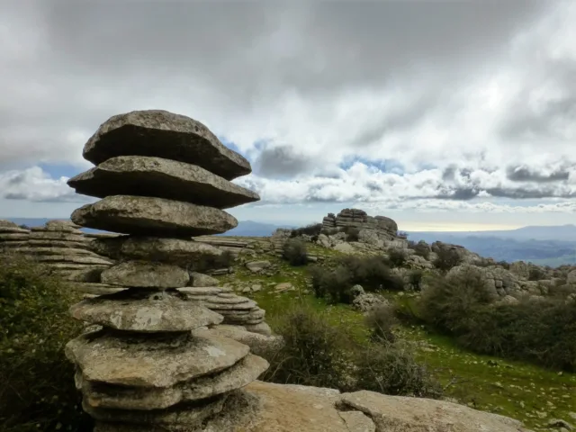
The Torcal de Antequera is a stunning natural park located in the province of Malaga, Andalusia, in southern Spain. It is renowned for its unique karst landscape, characterized by impressive limestone formations that have been shaped by millions of years of erosion.

Covering an area of approximately 17 square kilometers, the Torcal de Antequera is a designated UNESCO World Heritage site and one of the most important karst landscapes in Europe. The park is situated about 13 kilometers south of the town of Antequera and is easily accessible by road.

The landscape of the Torcal de Antequera is a result of the slow dissolution of limestone over millions of years, creating a labyrinth of narrow alleys, towering cliffs, and bizarre rock formations. These formations, often referred to as “tors,” come in various shapes and sizes, resembling animals, human profiles, and other whimsical figures. The park’s unique geology and the extraordinary shapes of the rocks have made it a popular destination for geologists, nature lovers, hikers, and photographers.

The Torcal de Antequera is also home to a diverse range of flora and fauna. The harsh and rocky terrain provides a habitat for many specialized plant species, including several endemic varieties. Wildlife such as wild boars, ibex, foxes, and numerous bird species can be spotted in the park, making it a haven for nature enthusiasts.

Visitors to the Torcal de Antequera can explore its natural wonders through a network of well-marked trails and hiking routes. The park offers a range of paths catering to different difficulty levels, allowing visitors to admire the breathtaking views and get closer to the unique rock formations. Guided tours and interpretive signs are available to help visitors understand the geological and ecological significance of the area.

In addition to its natural beauty, the Torcal de Antequera holds historical and archaeological importance. Prehistoric remains, including dolmens and rock paintings, have been discovered in the area, providing insights into the early human presence in the region.

Whether you are interested in geology, hiking, nature photography, or simply immersing yourself in a captivating natural setting, the Torcal de Antequera offers a truly remarkable experience. Its otherworldly landscapes and rich biodiversity make it a must-visit destination for anyone exploring the beauty of southern Spain.

The Torcal de Antequera Geological Formation

The Torcal de Antequera’s unique karst landscape and rock formations are the result of a combination of geological processes that have taken place over millions of years. Tectonic activity and erosion have played crucial roles in shaping this remarkable natural wonder.

The formation of the Torcal de Antequera began around 150 million years ago during the Late Jurassic period. At that time, the area was covered by a shallow sea. Over time, the remains of marine organisms, such as shells and corals, accumulated on the seabed and formed layers of sediment.

About 100 million years ago, tectonic forces began to uplift the region, raising the limestone layers above sea level. This tectonic activity, primarily caused by the collision of tectonic plates, led to the formation of mountain ranges and the uplifting of the limestone deposits.

As the limestone emerged from the sea, a long process of chemical and physical weathering started to shape the landscape. Rainwater, containing carbon dioxide from the atmosphere, seeped into the limestone, forming a weak carbonic acid. This acid gradually dissolved the calcium carbonate in the limestone, creating cracks and cavities.

Over millions of years, this dissolution process, known as karstification, intensified, resulting in the formation of an intricate system of underground caves, tunnels, and fissures. As the caves developed, the water table dropped, leaving the upper parts of the caves exposed to the elements.

The exposed limestone underwent further weathering through erosion caused by rain, wind, and temperature changes. These natural forces sculpted the limestone into the unique shapes and formations seen in the Torcal de Antequera today. The erosive action of water gradually widened the cracks and fissures, creating the distinctive narrow alleys and vertical cliffs.

The combination of the karstification process and erosion gave rise to the Torcal de Antequera’s impressive rock formations, known as “tors.” These tors exhibit various shapes and sizes, ranging from mushroom-like formations to pillars and ridges. The erosion has also resulted in the creation of vast limestone pavements, with smooth surfaces adorned with unique patterns.

It’s important to note that the Torcal de Antequera’s geological formation is an ongoing process. The limestone continues to be shaped and transformed by weathering and erosion, ensuring that this stunning karst landscape remains a dynamic and ever-changing natural wonder.

The Torcal de Antequera’s Natural Features

The Torcal de Antequera is not only known for its geological formations but also for its rich biodiversity. The unique karst landscape provides a habitat for a diverse range of plant and animal species, some of which are endangered or rare.

Flora: The Torcal de Antequera hosts a variety of plant species adapted to the harsh limestone terrain. The rocky outcrops and crevices support the growth of specialized flora, including endemic species that are unique to the area. Among the plant species found in the Torcal are thyme, rosemary, lavender, rock roses, orchids, and various grasses and mosses.

Fauna: The park is home to a diverse array of animal species, making it an important habitat for wildlife. Mammals that can be found in the Torcal de Antequera include wild boars, genets, badgers, foxes, and rabbits. One of the iconic species of the area is the Spanish ibex (Capra pyrenaica), a mountain goat well adapted to rocky terrain. Bird enthusiasts can spot species such as Bonelli’s eagles, kestrels, owls, vultures, and a variety of migratory birds.

Endangered and Rare Species: The Torcal de Antequera serves as a refuge for several endangered and rare species. One notable example is the Spanish ibex, which has faced threats due to hunting and habitat loss in other regions. The park provides a protected environment for these graceful animals to thrive. Another notable species is the Bonelli’s eagle, a bird of prey that is considered endangered in Spain. The Torcal’s rugged cliffs and open spaces offer suitable nesting grounds for this majestic bird.

Importance as a Nature Reserve: The Torcal de Antequera holds significant importance as a nature reserve and protected area. Its unique karst landscape and diverse ecosystems make it a valuable site for scientific research, education, and conservation efforts. The park’s designation as a UNESCO World Heritage site underscores its global significance and highlights the need for its preservation.

As a nature reserve, the Torcal de Antequera plays a vital role in the conservation of biodiversity. It serves as a sanctuary for numerous plant and animal species, including those that are rare, endangered, or endemic to the area. The park’s protected status ensures that these species are safeguarded and their habitats remain intact.

Additionally, the Torcal de Antequera offers opportunities for eco-tourism, allowing visitors to appreciate and learn about the unique natural features and wildlife of the region. Guided tours, interpretive centers, and educational programs promote awareness and understanding of the park’s ecological value, fostering a sense of conservation and environmental stewardship.

Overall, the Torcal de Antequera’s role as a nature reserve is crucial for preserving its exceptional biodiversity, contributing to scientific knowledge, and providing a captivating experience for visitors who wish to explore and appreciate the wonders of nature.

The Torcal de Antequera Tourism and Recreation

The Torcal de Antequera offers various visitor facilities, amenities, and recreational opportunities to enhance the experience of tourists and nature enthusiasts.

Visitor Facilities and Amenities:

  1. Visitor Center: The park has a dedicated visitor center where visitors can obtain information about the park’s geology, flora, fauna, and hiking trails. The center may also provide maps, brochures, and exhibits showcasing the natural and cultural heritage of the Torcal de Antequera.
  2. Interpretive Signs: Throughout the park, you will find informative signs providing details about the geological features, plant and animal species, and historical significance of different areas. These signs offer educational insights as you explore the park.
  3. Parking: The Torcal de Antequera has designated parking areas for visitors, ensuring convenient access to the park’s entrance.

Hiking and Nature Trails: The park features a network of well-maintained hiking trails and nature paths, allowing visitors to explore its unique landscape and appreciate its natural beauty. The trails cater to different difficulty levels, providing options for both casual walkers and experienced hikers. Some popular trails include:

  1. Ruta Verde (Green Route): This is the easiest and most accessible trail, suitable for all ages and fitness levels. It provides a circular route that allows visitors to admire the park’s limestone formations and enjoy panoramic views of the surrounding countryside.
  2. Ruta Amarilla (Yellow Route): This intermediate-level trail takes visitors deeper into the park, passing through various karst formations and offering more challenging terrain.
  3. Ruta Roja (Red Route): This is the most demanding trail, recommended for experienced hikers. It takes visitors to remote areas of the park, providing an opportunity to explore the rugged landscapes and discover hidden gems.

Guided Tours and Educational Programs: The Torcal de Antequera offers guided tours and educational programs to enhance visitors’ understanding of the park’s geology, flora, and fauna. These programs may be conducted by knowledgeable guides or park rangers who provide insights into the natural and cultural heritage of the area.

Guided tours can be arranged through the visitor center or specialized tour operators, offering a more in-depth exploration of the park’s features. These tours may focus on specific themes, such as geology, wildlife, or cultural history, providing a comprehensive and educational experience.

Educational programs, especially designed for schools or organized groups, offer interactive learning opportunities. They may include activities like nature walks, workshops, and hands-on experiences related to the park’s ecosystem.

It is advisable to check the availability and schedule of guided tours and educational programs in advance, as they may vary depending on the season and demand.

By providing visitor facilities, hiking trails, guided tours, and educational programs, the Torcal de Antequera ensures that visitors have a fulfilling and enriching experience while promoting conservation and sustainable tourism practices in this remarkable natural reserve.

Recap of the key points about the Torcal de Antequera

  1. Location: The Torcal de Antequera is located in the province of Malaga, Andalusia, in southern Spain, approximately 13 kilometers south of the town of Antequera.
  2. Geological Formation: The park’s unique karst landscape and rock formations are the result of millions of years of tectonic activity, erosion, and karstification. The dissolution of limestone created a labyrinth of narrow alleys, towering cliffs, and whimsical rock formations known as “tors.”
  3. Flora and Fauna: The Torcal de Antequera is home to a diverse range of plant and animal species. The rocky terrain supports specialized flora, including endemic varieties. Wildlife such as Spanish ibex, wild boars, foxes, and various bird species can be found in the park.
  4. Endangered and Rare Species: The Torcal de Antequera serves as a refuge for endangered and rare species, including the Spanish ibex and Bonelli’s eagle. The park plays a crucial role in their conservation.
  5. Importance as a Nature Reserve: The Torcal de Antequera is a designated UNESCO World Heritage site and holds significant importance as a nature reserve. Its conservation efforts, scientific research, and educational programs contribute to preserving its biodiversity and promoting environmental awareness.
  6. Visitor Facilities and Amenities: The park offers visitor facilities such as a visitor center, interpretive signs, and designated parking areas, ensuring a convenient and informative experience for visitors.
  7. Hiking and Nature Trails: The Torcal de Antequera provides a network of hiking trails and nature paths suitable for different difficulty levels. Trails like the Green, Yellow, and Red routes allow visitors to explore the park’s landscapes and enjoy panoramic views.
  8. Guided Tours and Educational Programs: The park offers guided tours and educational programs conducted by knowledgeable guides and rangers, allowing visitors to gain a deeper understanding of the park’s geology, flora, fauna, and cultural history.

Overall, the Torcal de Antequera is a captivating natural wonder, combining stunning geological formations, rich biodiversity, and opportunities for exploration and education. It offers a unique and immersive experience for visitors, emphasizing the importance of conservation and appreciation for the natural world.

FAQ

How do I get to the Torcal de Antequera?

The Torcal de Antequera is located approximately 13 kilometers south of the town of Antequera in Andalusia, Spain. It is easily accessible by road, and there are signposts directing you to the park from Antequera. You can use private transportation or take a bus or taxi from Antequera to reach the park.

Is there an entrance fee to visit the Torcal de Antequera?

Yes, there is an entrance fee to visit the Torcal de Antequera. The fees may vary depending on factors such as age, residency status, and the type of visit (individual or group). It’s advisable to check the official website or contact the park’s visitor center for the most up-to-date information regarding entrance fees.

Are there guided tours available in the Torcal de Antequera?

Yes, guided tours are available in the Torcal de Antequera. You can arrange guided tours through the park’s visitor center or with specialized tour operators. Guided tours offer informative insights into the park’s geology, flora, fauna, and cultural history, enhancing your experience and understanding of the area.

Can I hike in the Torcal de Antequera?

Yes, hiking is a popular activity in the Torcal de Antequera. The park offers a network of well-marked hiking trails catering to different difficulty levels. You can explore the park’s unique landscapes, rock formations, and enjoy panoramic views by following the designated hiking routes. It’s important to follow the trail markings and take necessary precautions while hiking.

Are there facilities for picnics in the Torcal de Antequera?

Yes, the Torcal de Antequera provides picnic areas where visitors can enjoy meals surrounded by the natural beauty of the park. These areas usually have tables, benches, and waste disposal facilities. It’s recommended to bring your own food and drinks, as there might not be any food vendors within the park.

Can I camp overnight in the Torcal de Antequera?

No, camping overnight is not permitted within the Torcal de Antequera. The park is a nature reserve, and overnight stays are not allowed to preserve the natural environment and ensure visitor safety. However, there are accommodation options available in nearby towns like Antequera if you wish to stay in the area.

Is the Torcal de Antequera suitable for families with children?

Yes, the Torcal de Antequera is suitable for families with children. The park offers various hiking trails of different difficulty levels, including easier routes that are suitable for all ages. It’s advisable to choose trails that are appropriate for the physical abilities of your children and ensure that they follow safety guidelines while exploring the park.

Can I bring my dog to the Torcal de Antequera?

Pets, including dogs, are generally not allowed in the Torcal de Antequera to protect the park’s flora, fauna, and other visitors. However, it’s recommended to check the specific regulations and guidelines of the park or contact the visitor center for any exceptions or designated areas where pets may be allowed on a leash.

Are there restrictions on photography in the Torcal de Antequera?

No, there are no specific restrictions on photography in the Torcal de Antequera. Visitors are generally allowed to take photographs for personal use and non-commercial purposes. However, it’s important to respect the park’s regulations and guidelines, which may include restrictions on using tripods or drones. Commercial or professional photography may require prior permission.

The Zion National Park, USA

Zion National Park is a breathtaking natural wonder located in the southwestern United States. Situated in the state of Utah, Zion National Park is known for its stunning red rock canyons, towering sandstone cliffs, and diverse ecosystems. It is one of the most popular and beloved national parks in the country, attracting millions of visitors each year.

The park covers an area of approximately 229 square miles (590 square kilometers) and encompasses a variety of landscapes, ranging from lush forests to arid desert. It is renowned for its dramatic and awe-inspiring geology, which has been shaped over millions of years by the forces of wind, water, and erosion.

One of the park’s most iconic features is Zion Canyon, a deep and narrow gorge carved by the Virgin River. The canyon walls rise as high as 2,000 feet (610 meters) and display striking layers of red, pink, and white sandstone. Visitors can explore the canyon by hiking along its many trails, which offer stunning viewpoints and opportunities to observe the park’s unique flora and fauna.

Zion National Park is home to a remarkable array of plant and animal species. The park’s diverse habitats support a variety of vegetation, including desert plants such as cacti and Joshua trees, as well as riparian vegetation along the riverbanks. Wildlife enthusiasts can spot a range of creatures, including mule deer, bighorn sheep, mountain lions, and numerous bird species.

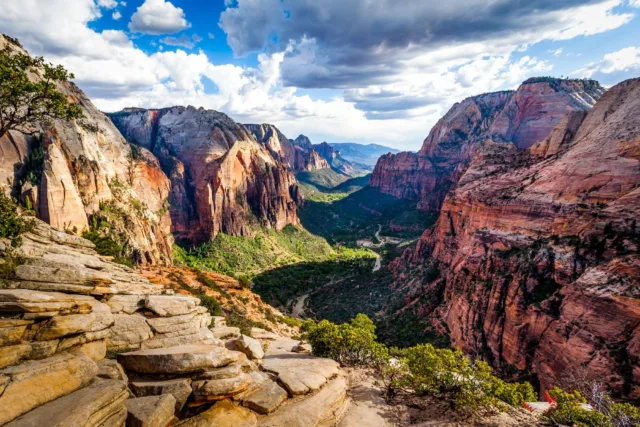
Hiking is one of the most popular activities in Zion National Park, with trails catering to different skill levels and interests. The park offers trails that range from easy strolls along paved paths to challenging hikes that involve steep ascents and narrow cliffs. The famous Angels Landing trail is particularly renowned for its thrilling and exposed final section, which rewards hikers with breathtaking views of the surrounding landscape.

Other notable attractions within Zion National Park include the Narrows, where visitors can hike through the Virgin River in a towering slot canyon, and the Emerald Pools, a series of picturesque waterfalls and pools nestled amid lush greenery.

To preserve and protect the park’s natural beauty and fragile ecosystems, Zion National Park has implemented measures to manage visitor numbers and minimize environmental impact. It is advisable to plan your visit in advance, especially during peak seasons, and be mindful of the park’s guidelines to ensure a safe and enjoyable experience.

Whether you are an outdoor enthusiast, nature lover, or simply seeking tranquility in a stunning natural setting, Zion National Park offers a truly awe-inspiring experience with its breathtaking landscapes, diverse wildlife, and memorable adventures.

Natural Features of Zion National Park

Zion National Park boasts a variety of awe-inspiring natural features that contribute to its stunning beauty and unique ecosystem. Here are some of the prominent natural features found within the park:

  1. Zion Canyon: The centerpiece of the park, Zion Canyon is a deep and narrow gorge carved by the Virgin River. The towering sandstone cliffs that line the canyon walls create a dramatic and breathtaking landscape.
  2. Virgin River: The Virgin River is a lifeline for the park’s ecosystem. It flows through Zion Canyon, sculpting the iconic rock formations and supporting diverse riparian vegetation along its banks.
  3. Sandstone Formations: Zion National Park is renowned for its magnificent sandstone formations. The park features towering cliffs, monoliths, and buttes, characterized by their vivid red, pink, and white hues. Notable formations include the Great White Throne, the Court of the Patriarchs, and Checkerboard Mesa.
  4. Slot Canyons: The park is home to several mesmerizing slot canyons, which are narrow, winding passages carved by water over time. The Narrows is a famous slot canyon where hikers can wade through the Virgin River and marvel at its towering walls.
  5. Kolob Canyons: Located in the northwest section of the park, Kolob Canyons offers a different perspective with its vibrant sandstone cliffs, natural arches, and panoramic vistas. It provides a quieter and less crowded experience for visitors.
  6. Hanging Gardens: Throughout the park, lush hanging gardens can be found clinging to the cliffs. These unique microenvironments are formed when water seeps out of the rocks, creating small oases with vibrant vegetation.
  7. Waterfalls: Zion National Park features several beautiful waterfalls. The Emerald Pools have a series of cascades and pools, while Weeping Rock showcases a stunning wall of water dripping from the cliff face.
  8. Virgin Narrows: This section of the Virgin River showcases a narrow, winding canyon with towering walls. Hiking through the Virgin Narrows is a popular adventure for visitors, immersing them in the beauty of the slot canyon.
  9. Wildlife: The park is home to a diverse array of wildlife, including mule deer, bighorn sheep, mountain lions, bobcats, coyotes, and various bird species. Spotting these animals in their natural habitat adds to the park’s allure.

These natural features, among others, make Zion National Park a captivating destination for nature enthusiasts, photographers, and outdoor adventurers alike. The harmonious blend of towering cliffs, lush vegetation, flowing rivers, and unique geological formations creates a truly unforgettable experience.

The Zion National Park Formation and Geological History

Zion National Park’s formation and geological history span millions of years, resulting in the striking landscapes seen today. The park’s story begins around 250 million years ago during the Mesozoic Era, specifically in the Triassic period.

During this time, the area that is now Zion National Park was a vast desert basin covered by a shallow sea. Sediments such as sand, silt, and clay were deposited in the basin over millions of years. These sediments eventually hardened and compacted to form thick layers of sedimentary rock.

Around 200 million years ago, during the Jurassic period, the region experienced a dramatic change. The supercontinent Pangaea began to break apart, leading to the creation of a massive rift valley called the Sevier Rift. This stretching and pulling of the Earth’s crust caused the formation of numerous faults and fractures in the area.

Over time, these faults and fractures played a crucial role in shaping the landscape of Zion National Park. The rocks that had accumulated in the basin during the Triassic period were uplifted, tilted, and exposed to the forces of erosion. Rivers and streams started to carve through the layers of sedimentary rock, gradually forming canyons and revealing the stunning geological formations seen today.

Around 13 million years ago, during the Miocene period, volcanic activity in the area deposited layers of ash and lava over the existing rock layers. These volcanic deposits can be seen in some parts of the park, adding further geological interest.

The most prominent feature of Zion National Park, Zion Canyon, was created by the relentless erosion of the Virgin River. As the river cut through the layers of sedimentary rock, it gradually deepened and widened the canyon, revealing the towering cliffs and narrow slot canyons that make the park so iconic.

The distinctive red, pink, and white hues of the sandstone found throughout the park are due to the presence of iron oxide minerals, such as hematite and goethite, which give the rocks their vibrant colors.

Today, the ongoing processes of weathering and erosion continue to shape Zion National Park’s geological features. Flash floods, freezing and thawing cycles, and the gradual wearing away of rock by wind and water all contribute to the ever-changing landscape.

Zion National Park stands as a testament to the immense geological forces that have shaped the Earth over millions of years. Its breathtaking cliffs, canyons, and rock formations offer visitors a glimpse into the park’s fascinating geological history.

The Zion National Park Rock Types and Stratigraphy

Zion National Park exhibits a diverse array of rock types and a complex stratigraphy, showcasing the geological history of the region. The park’s rock formations primarily consist of sedimentary rocks, which were deposited over millions of years. Here are some of the prominent rock types and their stratigraphy within Zion National Park:

  1. Navajo Sandstone: The Navajo Sandstone is the most prominent rock formation in the park and is responsible for the towering cliffs and mesas. It is a thick layer of cross-bedded, fine to medium-grained sandstone that displays stunning shades of red, pink, and white. The Navajo Sandstone represents the Jurassic-age geological period and is particularly well-exposed in Zion Canyon.
  2. Kayenta Formation: Found above the Navajo Sandstone, the Kayenta Formation consists of reddish-brown to purplish-brown sandstone and shale. This layer often weathers into slopes and forms the slopes and benches in the park. The Kayenta Formation also belongs to the Jurassic period and is known for its distinctive cliff-forming units.
  3. Moenave Formation: The Moenave Formation is a thin layer of interbedded sandstone, siltstone, and shale that overlies the Kayenta Formation. It exhibits a variety of colors, including red, yellow, purple, and gray. The Moenave Formation is of Early Jurassic age and can be seen in parts of the park, particularly in the Kolob Canyons section.
  4. Chinle Formation: The Chinle Formation, located above the Moenave Formation, is primarily composed of mudstone, shale, and siltstone. It is a multicolored formation, displaying hues of red, purple, brown, and green. Fossilized remains of plants and animals, including early dinosaurs, have been found within the Chinle Formation. This formation is of Late Triassic age.
  5. Temple Cap Formation: The Temple Cap Formation is an uppermost layer of the park’s stratigraphy, dating back to the Early Jurassic period. It consists of sandstone, siltstone, and limestone. Although not as widespread as the Navajo Sandstone, the Temple Cap Formation can be observed in certain areas, such as the Kolob Terrace.

Apart from these major formations, volcanic rocks, including basalt and andesite, can be found in some areas of the park, resulting from ancient volcanic activity during the Miocene period.

The diverse rock types and stratigraphy of Zion National Park provide a glimpse into the geological processes and ancient environments that shaped the region over millions of years. The layering, colors, and textures of the rocks contribute to the park’s stunning beauty and make it a captivating destination for geologists and visitors alike.

The Zion National Park Main Attractions and Points of Interest

Zion National Park offers a plethora of attractions and points of interest that showcase its natural beauty and provide memorable experiences for visitors. Here are some of the main attractions and points of interest within the park:

Zion Canyon: Zion Canyon is the park’s most iconic attraction. Visitors can explore the canyon by hiking along its scenic trails, including the famous Riverside Walk. The canyon’s towering sandstone cliffs, stunning rock formations, and the tranquil Virgin River running through it create a breathtaking landscape.

Angels Landing: Angels Landing is a challenging but rewarding hiking trail that offers unparalleled panoramic views of Zion Canyon. The trail features steep switchbacks and a final exposed section with chains to assist hikers as they make their way to the summit.

Angels Landing

The Narrows: The Narrows is a world-famous hike where visitors can venture into the narrowest section of Zion Canyon. Hiking through the Virgin River within the towering walls of the slot canyon is a unique and unforgettable experience.

The Narrows

Emerald Pools: The Emerald Pools are a series of pools and waterfalls located at the base of towering cliffs. Visitors can explore the lower, middle, and upper pools, each offering its own distinct beauty and tranquility.

Emerald Pools

Weeping Rock: Weeping Rock is a short trail that leads to a natural alcove where water seeps out of the sandstone, creating a gentle waterfall and a hanging garden of ferns and mosses.

Weeping Rock

Kolob Canyons: Located in the northwest section of the park, Kolob Canyons offer stunning vistas, picturesque drives, and hiking trails. The red rock canyons and expansive views provide a quieter and less crowded experience for visitors.

Kolob Canyons

Observation Point: The hike to Observation Point is challenging but provides one of the most breathtaking views in the park. From the top, visitors can enjoy a panoramic view of Zion Canyon and the surrounding landscapes.

Observation Point

Zion-Mt. Carmel Highway and Tunnel: This scenic road leads visitors through the park and features the Zion-Mt. Carmel Tunnel, an engineering marvel carved through the sandstone cliffs. The highway offers stunning views of the canyon and various pullouts for photo opportunities.

Zion-Mt. Carmel Highway and Tunnel

Wildlife Spotting: Zion National Park is home to a diverse range of wildlife. Visitors may have the opportunity to spot mule deer, bighorn sheep, squirrels, various bird species, and sometimes even elusive animals like mountain lions and bobcats.

Stargazing: The park’s dark skies make it an excellent location for stargazing. On clear nights, visitors can witness a mesmerizing display of stars, planets, and the Milky Way stretching across the sky.

Stargazing of The Zion National Park

These attractions and points of interest in Zion National Park provide visitors with a chance to immerse themselves in the park’s awe-inspiring natural wonders, engage in outdoor activities, and create unforgettable memories.

FAQs

How do I get to Zion National Park?

To reach Zion National Park, you can fly into nearby airports such as Las Vegas McCarran International Airport or Salt Lake City International Airport. From there, you can rent a car and drive to the park. The park is also accessible by shuttle service from nearby towns.

When is the best time to visit Zion National Park?

The best time to visit Zion National Park is during the spring (March to May) and fall (September to November) when the weather is pleasant and temperatures are mild. Summer months can be hot, crowded, and prone to afternoon thunderstorms. Winter brings colder temperatures and occasional snowfall.

Are there entrance fees to visit Zion National Park?

Yes, there is an entrance fee to visit Zion National Park. The fee varies depending on the type of vehicle and is valid for multiple days. You can check the current fee structure on the park’s official website.

Are pets allowed in Zion National Park?

Pets are allowed in certain areas of Zion National Park but must be leashed at all times. They are not permitted on most of the trails, on shuttle buses, or in the backcountry. It is important to review the park’s pet regulations before visiting.

Can I camp in Zion National Park?

Yes, there are camping options within Zion National Park. The park offers several campgrounds, including South Campground and Watchman Campground, which provide tent and RV camping. Reservations are recommended, especially during peak seasons.

Are there hiking trails suitable for all skill levels?

Yes, Zion National Park offers hiking trails suitable for various skill levels. There are easy, paved trails like the Riverside Walk, moderate trails like the Emerald Pools, and more challenging hikes like Angels Landing and The Narrows. It’s important to choose a trail that matches your fitness level and experience.

Is it necessary to use the park shuttle system?

Yes, the park operates a mandatory shuttle system to manage traffic congestion within Zion Canyon during peak seasons. Private vehicles are restricted from driving in certain areas, and visitors are required to use the shuttle buses. Exceptions apply during the off-peak season.

Can I go horseback riding in Zion National Park?

Horseback riding is allowed in certain areas of Zion National Park. The park has designated horse trails, and guided horseback riding tours are available. It is advisable to check with the park or authorized concessionaires for specific information and permits.

Are there accommodations and dining options within the park?

Yes, Zion National Park offers lodging options such as the Zion Lodge, which provides hotel rooms and cabins. There are also dining options available within the park, including a restaurant at Zion Lodge and a cafeteria-style eatery near the visitor center. Nearby towns outside the park offer additional accommodation and dining choices.

What safety precautions should I take when visiting Zion National Park?

When visiting Zion National Park, it is important to stay hydrated, wear appropriate footwear and clothing, and carry essential supplies such as sunscreen, water, and snacks. Always stay on designated trails, follow park regulations, and be mindful of wildlife. It’s also essential to be aware of weather conditions and potential flash floods in slot canyons.

Ha Long Bay, Vietnam

Ha Long Bay, located in northern Vietnam, is a stunning natural wonder and a UNESCO World Heritage Site. It is renowned for its breathtaking landscape of limestone islands and emerald waters, making it one of the country’s most popular tourist destinations.

The name “Ha Long” translates to “descending dragon,” and the bay’s mythological origins are deeply rooted in Vietnamese folklore. Legend has it that the islands were created by dragons that came down from the heavens, spitting out jewels and jade into the sea to form a defensive barrier against invaders.

Stretching over an area of approximately 1,553 square kilometers (600 square miles), Ha Long Bay features around 1,600 limestone karsts and islets, which vary in size and shape. These towering limestone formations emerge dramatically from the tranquil waters, creating a mesmerizing and otherworldly seascape.

The bay’s beauty lies not only in its karst landscape but also in its hidden caves, grottoes, and pristine sandy beaches. Visitors can explore these natural wonders by taking boat tours, kayaking, or even cruising on traditional junk boats, which are modeled after ancient sailing vessels. Cruising through the bay provides a unique perspective and allows travelers to fully immerse themselves in the awe-inspiring surroundings.

In addition to its natural splendor, Ha Long Bay is also home to a diverse ecosystem with rich biodiversity. The bay supports a wide range of plant and animal species, including some that are rare and endemic to the area. It is particularly known for its floating villages, where local communities live on houseboats, relying on fishing and aquaculture as their main livelihoods.

Tourism infrastructure in Ha Long Bay has developed significantly over the years, with a range of accommodations available, from luxurious resorts to budget-friendly guesthouses. Visitors can enjoy various activities, such as swimming, sunbathing, exploring caves like the famous Thien Cung Cave or Sung Sot Cave, and indulging in fresh seafood that the region is famous for.

Ha Long Bay’s outstanding natural beauty and cultural significance have made it an iconic symbol of Vietnam and a must-visit destination for travelers from around the world.

Geology and formation of Ha Long Bay

The geology and formation of Ha Long Bay are fascinating and contribute to its unique and spectacular landscape. The bay’s formation can be attributed to a combination of geological processes that took place over millions of years.

Located in the Gulf of Tonkin, which is part of the larger South China Sea. The foundation of the bay is composed mainly of limestone, a sedimentary rock formed from the accumulation of marine organisms such as coral, shellfish, and microorganisms.

Around 500 million years ago, during the Paleozoic era, the area that is now Ha Long Bay was submerged under a shallow sea. Over time, the remains of marine life settled and compacted, gradually forming thick layers of limestone.

Subsequent tectonic movements and geological changes caused the land to rise, exposing the limestone to weathering and erosion. The action of water, wind, and chemical processes worked together to shape the limestone into the unique karst formations seen in Ha Long Bay today.

The most distinctive features of the bay are the karsts, which are towering limestone pillars that rise dramatically from the water’s surface. These karsts vary in size, shape, and height, ranging from small islets to massive islands. Some of the karsts have been given imaginative names based on their appearances, such as Fighting Cock Island and Stone Dog Island.

The formation of the karsts in Ha Long Bay can be attributed to a combination of factors. First, the chemical composition of the limestone played a crucial role. Limestone is composed primarily of calcium carbonate, which is vulnerable to the dissolution action of weakly acidic water.

The bay’s environment, with its warm and humid climate, experiences a high degree of rainfall, contributing to the chemical weathering process. Rainwater absorbs carbon dioxide from the atmosphere, creating a weak carbonic acid solution. This slightly acidic water reacts with the limestone, dissolving and gradually wearing it away over time.

Another important factor in the formation of the karsts is the mechanical action of waves and tidal currents. The bay’s coastal erosion and the relentless pounding of the waves against the limestone cliffs resulted in the sculpting and carving of the karsts into their distinctive shapes. The softer layers of limestone erode faster, leaving behind the more resistant and prominent karst formations.

The combination of chemical dissolution, mechanical erosion, and the passage of millions of years has created the magnificent landscape of Ha Long Bay, with its maze of limestone islands, caves, and grottoes surrounded by emerald waters.

It’s worth noting that the geological processes shaping Ha Long Bay are ongoing. Erosion and weathering continue to shape and change the karsts, ensuring that this natural marvel remains dynamic and evolving.

Cultural and historical significance

Ha Long Bay holds significant cultural and historical importance to the people of Vietnam. Here are some key aspects of its cultural and historical significance:

  1. Folklore and Mythology: Steeped in Vietnamese folklore and mythology. As mentioned earlier, the name “Ha Long” translates to “descending dragon,” and according to legend, the bay was created by dragons that descended from the heavens to protect Vietnam. The dragons spit out jewels and jade, which formed the limestone karsts and islands, creating a natural barrier against invaders.
  2. Indigenous Communities: is home to several indigenous communities, including the Tày, Cao Lan, and Sán Dìu ethnic groups. These communities have a deep cultural connection to the bay, as they have lived in the region for generations. They have developed unique traditions, customs, and ways of life that are intertwined with the natural environment of the bay.
  3. Historical Significance: Served as an important strategic location throughout Vietnam’s history. The bay’s natural features, with its maze-like formations and hidden caves, provided shelter and a secure base for Vietnamese soldiers during times of conflict. During the Vietnam War, Ha Long Bay served as a strategic hiding spot for Vietnamese naval forces and played a role in military operations.
  4. Cultural Heritage: The region surrounding Ha Long Bay has a rich cultural heritage. The local communities have a strong fishing and maritime tradition, and their way of life is closely tied to the sea. Traditional fishing villages, floating markets, and wooden boats are common sights in the bay, showcasing the cultural practices and heritage of the local population.
  5. UNESCO World Heritage Site: In recognition of its outstanding universal value, Ha Long Bay was designated as a UNESCO World Heritage Site in 1994. It was recognized for its exceptional natural beauty, its unique geomorphological features, and its significant cultural and historical importance. This UNESCO status has helped preserve and protect the bay and has increased awareness and appreciation of its cultural significance on a global scale.
  6. Tourism and Economic Impact: Ha Long Bay’s cultural and historical significance has made it a major tourist destination in Vietnam. The influx of tourists has brought economic opportunities to the region, providing income and livelihoods for local communities. Tourism has also encouraged the preservation and promotion of local culture, arts, and traditions, ensuring their continuity for future generations.

In summary, Ha Long Bay is not only a natural wonder but also a place of great cultural and historical significance in Vietnam. It is deeply rooted in Vietnamese mythology, has served as a strategic location in history, and is home to indigenous communities with unique cultural practices. Its UNESCO World Heritage status and the economic impact of tourism further highlight its cultural significance and the efforts to preserve its heritage.

Tourism in Ha Long Bay

Tourism in Ha Long Bay has flourished over the years, and the bay has become one of Vietnam’s most popular tourist destinations. Here are some key aspects of tourism in Ha Long Bay:

  1. Scenic Cruises and Boat Tours: One of the most popular ways to experience Ha Long Bay is through scenic cruises and boat tours. Visitors can embark on traditional junk boats, modern luxury cruises, or even smaller boats and explore the bay’s stunning landscape of limestone karsts and emerald waters. These tours often include visits to caves, grottoes, and floating villages, providing a comprehensive experience of the bay’s natural beauty.
  2. Kayaking and Water Activities: Ha Long Bay offers opportunities for kayaking and engaging in various water activities. Travelers can rent kayaks or join guided kayaking tours to paddle through the bay’s tranquil waters, exploring hidden corners and getting up close to the karsts. Additionally, swimming, snorkeling, and scuba diving are popular activities, allowing visitors to enjoy the bay’s clear waters and marine life.
  3. Cave Exploration: Ha Long Bay is known for its captivating caves and grottoes. Thien Cung Cave and Sung Sot Cave (Surprise Cave) are among the most famous ones. These caves showcase impressive stalactite and stalagmite formations, unique rock formations, and chambers with colorful lighting, creating a mystical atmosphere for visitors to explore and admire.
  4. Floating Villages and Local Culture: Ha Long Bay is home to several floating villages, where local communities live on houseboats. These villages provide a glimpse into the daily lives of the fishing communities and offer cultural insights into their traditional ways of life. Visitors can witness traditional fishing techniques, visit floating markets, and even participate in activities like squid fishing or rowing bamboo boats.
  5. Beaches and Island Hopping: Ha Long Bay is dotted with beautiful sandy beaches, offering opportunities for sunbathing, swimming, and relaxation. Soi Sim Beach, Titov Island, and Cat Ba Island are popular spots for beach activities. Island hopping tours allow visitors to explore different islands, each with its unique features, viewpoints, and attractions.
  6. Accommodations and Infrastructure: Tourism development in Ha Long Bay has led to the establishment of a wide range of accommodations, from luxury resorts to budget-friendly guesthouses and homestays. The bay’s surrounding areas, including Halong City and Cat Ba Island, offer various options to suit different preferences and budgets. Infrastructure such as restaurants, cafes, souvenir shops, and entertainment venues cater to the needs of tourists.
  7. Environmental Conservation: Recognizing the importance of preserving the bay’s natural beauty, efforts have been made to promote sustainable tourism practices and environmental conservation. Measures have been taken to manage the number of visitors, control pollution, and raise awareness about protecting the delicate ecosystem of Ha Long Bay.

It’s important for visitors to follow responsible tourism practices, such as proper waste disposal, respecting local communities, and adhering to guidelines to help preserve the pristine environment of Ha Long Bay for future generations to enjoy.

FAQ

When is the best time to visit Ha Long Bay?

The best time to visit Ha Long Bay is during the spring (March to May) and autumn (September to November) seasons when the weather is pleasant with mild temperatures and lower chances of rainfall. However, Ha Long Bay can be visited year-round, and each season has its unique charm.

How do I get to Ha Long Bay?

The most common way to reach Ha Long Bay is by taking a bus or private car from Hanoi, which is approximately a 3 to 4-hour drive away. There are also options to take a seaplane or a helicopter for a more scenic and quicker journey.

How long should I plan to stay in Ha Long Bay?

A typical visit to Ha Long Bay can range from a day trip to several days, depending on your preferences and available time. Most tourists opt for overnight cruises to fully explore the bay and enjoy its scenic beauty. A 2 to 3-day itinerary is common and allows for a comprehensive experience of the area.

Can I swim in Ha Long Bay?

Yes, swimming is allowed in certain areas of Ha Long Bay. Many cruises and tours include swimming stops at designated spots, and some beaches are suitable for swimming. However, it’s important to follow safety guidelines and swim only in permitted areas.

Are there vegetarian or vegan food options in Ha Long Bay?

Yes, vegetarian and vegan food options are available in Ha Long Bay. Most cruises and restaurants offer a variety of dishes catering to different dietary preferences. It’s advisable to inform your tour operator or accommodation in advance to ensure suitable meal arrangements.

Are there any safety precautions I should take in Ha Long Bay?

While Ha Long Bay is generally safe for tourists, it’s essential to follow safety precautions. Pay attention to safety briefings provided by tour operators, wear life jackets during boat trips, and be cautious when swimming or engaging in water activities. It’s also advisable to have travel insurance that covers any unforeseen circumstances.

Can I visit Ha Long Bay independently or do I need to book a tour?

Visiting Ha Long Bay independently is possible, but most travelers opt for organized tours or cruises to fully experience the bay’s beauty and attractions. Joining a tour or cruise provides convenience, transportation, and access to knowledgeable guides who can enhance your experience.

What should I pack for a trip to Ha Long Bay?

Some essential items to pack for a trip to Ha Long Bay include comfortable clothing, swimwear, sunscreen, a hat, insect repellent, a camera, and any necessary medications. If you plan to stay overnight on a cruise, pack an overnight bag with toiletries and a change of clothes.

Are there any restrictions on photography in Ha Long Bay?

Photography is generally unrestricted in Ha Long Bay, and you can capture the beautiful scenery to your heart’s content. However, some caves or specific areas may have restrictions on flash photography or the use of tripods, so it’s advisable to follow any guidelines provided by your tour guide or signage.

What are some popular activities to do in Ha Long Bay besides cruising?

Apart from cruising, popular activities in Ha Long Bay include kayaking, exploring caves like Thien Cung Cave and Sung Sot Cave, visiting floating villages, hiking on Cat Ba Island, and enjoying the local seafood cuisine. Additionally, you can indulge in water sports, such as snorkeling or scuba diving, and take part in cooking classes to learn about Vietnamese cuisine.

The Pulpit Rock or Preikestolen, Norway

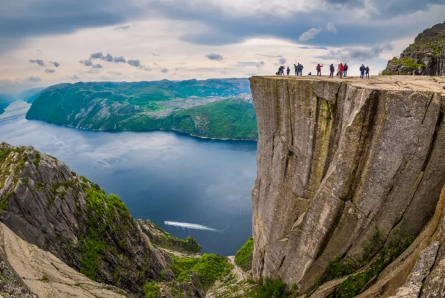
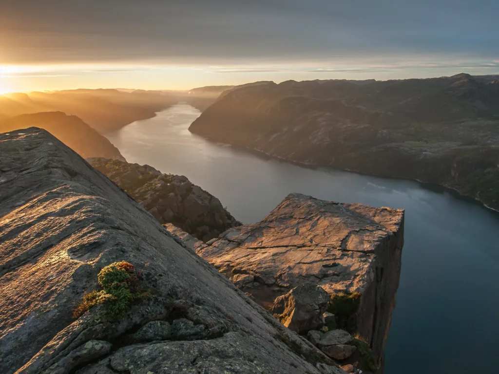
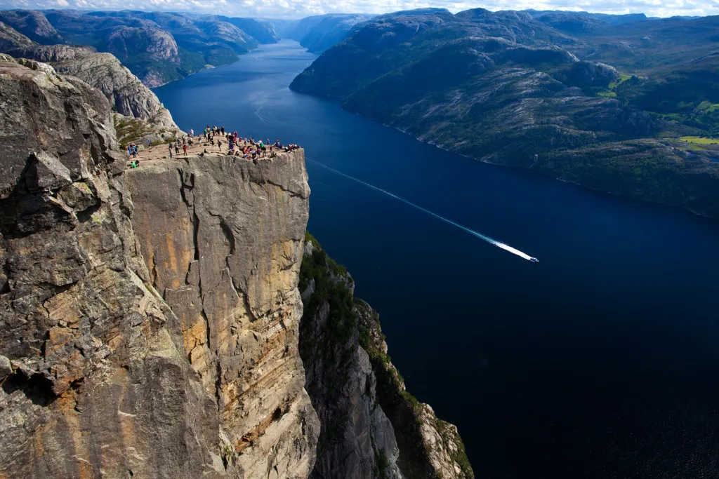
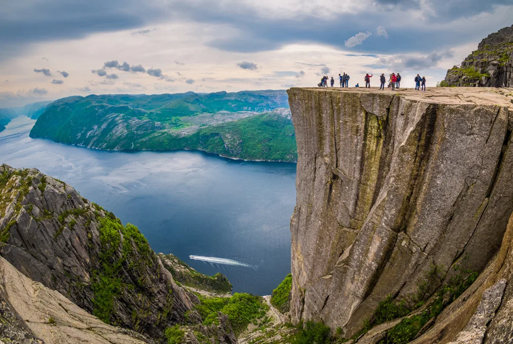
The Pulpit Rock, also known as Preikestolen, is a breathtaking natural landmark located in Norway. It is one of the most iconic and popular tourist destinations in the country, attracting thousands of visitors from around the world each year. The Pulpit Rock is renowned for its dramatic cliffs, which rise approximately 604 meters (1,982 feet) above the Lysefjord, offering an awe-inspiring view of the surrounding landscape.

Situated in southwestern Norway, near the city of Stavanger, the Pulpit Rock is a part of the larger Ryfylke region. The formation itself is a flat, almost rectangular plateau, measuring approximately 25 by 25 meters (82 by 82 feet). This massive rock platform appears to be precariously balanced on the edge of the towering cliff face, creating a mesmerizing sight that captivates all who visit.

To reach the Preikestolen, visitors must embark on a challenging yet rewarding hike. The trail leading to the summit starts at the Preikestolhytta mountain lodge, which serves as the starting point for most hikers. The hike itself is approximately 3.8 kilometers (2.4 miles) long and takes around 2 to 4 hours to complete, depending on one’s fitness level and pace. Along the way, hikers encounter diverse terrain, including steep ascents, rocky paths, and scenic landscapes.

Upon reaching the top, adventurers are rewarded with a jaw-dropping panoramic view of the Lysefjord and the surrounding mountains. The sheer cliff drop and the vastness of the fjord below create a sense of awe and wonder. Many visitors choose to sit or lie down on the flat rock surface, enjoying the peacefulness and admiring the natural beauty of the Norwegian wilderness.

It’s important to note that safety precautions should be taken when visiting the Preikestolen. The trail can be challenging, especially during inclement weather or in winter when icy conditions prevail. Visitors are advised to wear appropriate footwear, carry essential supplies, and be cautious while exploring the area.

The Pulpit Rock has gained global recognition through various forms of media, including movies, documentaries, and photographs. Its distinctive appearance and breathtaking vistas make it a favorite subject for photographers, outdoor enthusiasts, and nature lovers alike.

Whether you are seeking a thrilling adventure, a memorable hike, or simply a chance to immerse yourself in Norway’s natural wonders, the Pulpit Rock is a destination that should not be missed. It offers an unforgettable experience and a profound connection with nature that will leave a lasting impression on all who venture to its precipitous edge.

Geological Formation of The Pulpit Rock

The geological formation is a result of millions of years of natural processes and geological forces shaping the landscape of Norway.

Located in the Ryfylke region of southwestern Norway, situated near the Lysefjord. It is primarily composed of a massive cliff face that rises approximately 604 meters (1,982 feet) above the fjord. The cliff itself is made up of layers of horizontally stratified rocks, predominantly consisting of granite, gneiss, and migmatite.

The formation began around 10,000 years ago during the last Ice Age, known as the Weichselian glaciation. The massive ice sheets that covered Norway during this time period exerted tremendous pressure on the land, causing erosion and reshaping the terrain. Glacial activity played a significant role in sculpting the fjords, including the Lysefjord, which is a prominent feature of the area surrounding the Pulpit Rock.

As the glaciers receded, the exposed rock formations underwent further weathering and erosion due to natural elements such as wind, water, and frost action. Over time, the forces of nature shaped the cliffs, wearing away softer layers of rock and leaving behind the more resistant granite and gneiss layers that form the Pulpit Rock.

The distinctive flat plateau, itself is the result of selective erosion. The layers of rock on the plateau were relatively harder and more resistant to erosion compared to the surrounding layers. This differential erosion, combined with the underlying structural features of the rocks, created the unique and almost rectangular shape of the Pulpit Rock.

It’s important to note that the Preikestolen continues to undergo geological processes, albeit at a slow pace. Weathering, erosion, and occasional rockfalls contribute to the ongoing evolution of the cliff face. However, the rock formation is believed to be stable and has been a prominent landmark for thousands of years.

Today, the Pulpit Rock stands as a testament to the geological history of Norway, showcasing the remarkable forces of nature that have shaped the region over millennia. Its towering cliffs and stunning views are a testament to the awe-inspiring beauty and natural wonders that can be found in the Norwegian landscape.

The Pulpit Rock Physical Characteristics

The Pulpit Rock, or Preikestolen, possesses distinct physical characteristics that contribute to its unique allure and visual impact. Here’s a detailed description of its size, shape, elevation, composition, and coloration:

Size and Shape: The Pulpit Rock is a large and imposing natural formation with a flat, rectangular plateau at its summit. The plateau measures approximately 25 by 25 meters (82 by 82 feet), providing ample space for visitors to walk around and admire the surrounding scenery. Its relatively expansive size allows for unobstructed views of the Lysefjord and the encompassing landscape.

Elevation: Sitting atop a towering cliff face, the Pulpit Rock rises to an impressive height of approximately 604 meters (1,982 feet) above the waters of the Lysefjord. This substantial elevation gives visitors a breathtaking vantage point, overlooking the fjord and the picturesque Norwegian wilderness.

Composition: The Pulpit Rock is primarily composed of various types of rock, predominantly granite, gneiss, and migmatite. Granite, a coarse-grained igneous rock, is known for its durability and resistance to weathering. Gneiss is a metamorphic rock characterized by its banded appearance, formed from the recrystallization of pre-existing rocks under intense heat and pressure. Migmatite is a complex rock that exhibits both metamorphic and igneous characteristics.

The layers of granite, gneiss, and migmatite give the Pulpit Rock its distinct appearance, with different rock types visible in the exposed cliff face. The interplay of these rocks contributes to the rock formation’s strength and stability, allowing it to withstand the forces of erosion and maintain its iconic shape.

Coloration: The colors of the Pulpit Rock vary depending on the rock types present. Granite typically exhibits a light gray to pinkish hue, while gneiss can range from gray to shades of white, black, or pink. Migmatite often displays a combination of light and dark bands, showcasing contrasting shades of gray, white, or black.

When viewed from a distance or up close, the Pulpit Rock’s coloration creates a visually captivating mosaic of earthy tones, adding to the overall aesthetic appeal of the site.

In summary, the Pulpit Rock’s physical characteristics encompass its size, shape, elevation, composition, and coloration. Its imposing size and height, combined with the distinct flat plateau, allow for panoramic views of the Lysefjord. Composed primarily of granite, gneiss, and migmatite, the rock formation displays a range of colors, creating a striking visual spectacle amidst the rugged Norwegian landscape.

The Pulpit Rock Formation Mechanisms

The formation of the Pulpit Rock, or Preikestolen, is attributed to a combination of geological processes that have shaped the landscape of the region over millions of years. Key factors in its formation include erosion, weathering, and glacial activity. Let’s explore each of these mechanisms:

Erosion: Erosion played a significant role in the formation of the Pulpit Rock. As the glaciers retreated during the last Ice Age, the Lysefjord and its surrounding mountains were exposed to the forces of wind, water, and ice. Over time, these elements worked together to erode the softer rock layers, gradually sculpting the steep cliffs that make up the Pulpit Rock.

Weathering: Weathering, both mechanical and chemical, has contributed to the formation of the Pulpit Rock. Mechanical weathering occurs when physical forces, such as frost action and pressure changes, break down rocks into smaller pieces. The freeze-thaw cycles, common in colder climates, can cause cracks in the rock, further aiding in the weathering process. Chemical weathering involves the chemical alteration of rock surfaces due to processes like dissolution, oxidation, or hydrolysis. The combination of mechanical and chemical weathering processes has helped shape the distinct features of the Pulpit Rock over time.

Glacial Activity: During the last Ice Age, massive glaciers covered the region, including the Lysefjord area. These glaciers exerted tremendous pressure on the landscape, carving out deep valleys and fjords. As the glaciers moved across the land, they eroded and scoured the bedrock, contributing to the formation of the Lysefjord. Glacial activity also played a role in creating the steep cliffs and valleys surrounding the Pulpit Rock, as well as shaping the overall topography of the area.

Selective Erosion: The unique flat plateau that characterizes the Pulpit Rock is a result of selective erosion. The layers of rock on the plateau are composed of harder and more resistant materials, such as granite and gneiss. These rocks were able to withstand erosion better than the surrounding softer rocks, resulting in the formation of the flat surface.

Over millions of years, these geological processes of erosion, weathering, and glacial activity have worked in concert to shape the Pulpit Rock into the awe-inspiring natural formation that it is today. The forces of nature have sculpted the cliffs, exposed the underlying rock layers, and contributed to the remarkable beauty and grandeur of the Norwegian landscape.

Cultural and Historical Significance

The Pulpit Rock holds cultural and historical significance, deeply rooted in Norwegian heritage. It has captured the imagination of locals and visitors alike, inspiring stories, folklore, and a sense of awe throughout history. Here’s an exploration of its cultural and historical importance, as well as some associated folklore:

  1. Cultural Significance: The Pulpit Rock has become an iconic symbol of Norwegian nature and is often regarded as one of the country’s most treasured landmarks. It has been celebrated in literature, art, and photography, embodying the beauty and grandeur of Norway’s wilderness. The rock formation’s popularity has grown over time, attracting tourists from around the world and contributing to the local economy through tourism.
  2. Historical Significance: While the Pulpit Rock does not have significant historical events directly associated with it, the region it is located in, including the Lysefjord, has a rich history dating back thousands of years. The fjord has been an important transportation route and has served as a home for settlements and trade activities since ancient times.
  3. Folklore and Myths: The Pulpit Rock has inspired various folklore, myths, and legends that have been passed down through generations. One popular legend tells the story of a troll who slept on the Pulpit Rock and, upon awakening, left a giant footprint on the flat surface. This folklore is often shared to explain the unique shape of the rock formation.

Additionally, the rock has been associated with ancient Norse mythology. It has been likened to the mythical Bifröst, a rainbow bridge connecting the realms of gods and humans. The towering cliffs and ethereal beauty of the site contribute to its mythical allure.

  1. Cultural and Outdoor Activities: The Pulpit Rock has also become a site for cultural and outdoor activities. Every year, on the last Thursday of July, a race called “Preikestolen Fjellstue Opp” takes place, where participants race up the trail to the Pulpit Rock. The event attracts both locals and international participants, showcasing the cultural importance of the site as a place for physical challenges and community engagement.

Additionally, the Pulpit Rock serves as a popular destination for hiking, climbing, and outdoor exploration. Many visitors seek the thrill of reaching the summit and experiencing the remarkable views it offers.

In summary, the Pulpit Rock holds cultural and historical significance in Norway. It has inspired admiration, captured the imagination of people throughout history, and contributed to local folklore and legends. Its natural beauty, cultural symbolism, and association with mythology have cemented its place as an important and cherished landmark in Norwegian culture.

The Pulpit Rock Tourist Attraction

Preikestolen, has gained immense popularity as a tourist destination, attracting visitors from around the world. Here’s an overview of its status as a tourist attraction, along with information on visitor facilities, hiking trails, and safety measures:

Popularity as a Tourist Destination: The Pulpit Rock is widely recognized as one of Norway’s most iconic and breathtaking natural landmarks. Its striking cliffs, panoramic views of the Lysefjord, and unique rock formation draw tourists who seek awe-inspiring landscapes and outdoor adventures. The site’s popularity has grown significantly over the years, with a substantial increase in visitor numbers.

Visitor Facilities: To accommodate the growing number of tourists, visitor facilities have been developed around the Pulpit Rock. The Preikestolhytta mountain lodge serves as a starting point for hikers and offers amenities such as accommodation, a café, and restroom facilities. The lodge provides valuable information about the hiking trail, weather conditions, and safety guidelines.

Hiking Trails: The main way to reach the Preikestolen is via a hiking trail that starts at the Preikestolhytta mountain lodge. The trail is approximately 3.8 kilometers (2.4 miles) long and takes an average of 2 to 4 hours to complete, depending on one’s fitness level and pace. The route encompasses diverse terrain, including steep ascents, rocky sections, and scenic viewpoints.

Safety Measures: Safety is of utmost importance for visitors to the Pulpit Rock. Several safety measures and guidelines are in place to ensure a secure experience. These include:

  1. Weather Awareness: It is crucial to be aware of weather conditions before embarking on the hike. The trail can become slippery and dangerous during rain, snow, or icy conditions. Checking weather forecasts and consulting with staff at the mountain lodge is advisable.
  2. Proper Equipment: Wearing appropriate footwear, such as sturdy hiking boots, is essential for a safe and comfortable hike. It is also advisable to dress in layers, carry extra clothing, and bring essential supplies like water and snacks.
  3. Trail Markings and Information: The hiking trail is well-marked with red Ts and signage, guiding visitors along the correct path. Information boards along the trail provide guidance and safety reminders.
  4. Caution at the Cliff Edge: The Pulpit Rock’s cliffs have sheer drops, and caution should be exercised near the edge. Visitors are advised to stay within safe distances and avoid any risky behavior.

Additionally, during periods of extreme weather or hazardous conditions, access to the Pulpit Rock may be restricted for safety reasons.

It’s important for visitors to familiarize themselves with safety guidelines and respect the natural environment while exploring the Pulpit Rock. By following these measures, visitors can have an enjoyable and secure experience at this remarkable tourist attraction.

Please note that specific safety measures and regulations may evolve over time, so it is recommended to consult updated information and local authorities before planning a visit.

FAQs

How do I get to the Pulpit Rock?

The Pulpit Rock can be reached by taking a ferry from Stavanger to the Lysefjord, followed by a bus or car ride to the Preikestolhytta mountain lodge. From there, a hiking trail leads to the Pulpit Rock.

How long is the hike to the Pulpit Rock?

The hike to the Pulpit Rock is approximately 3.8 kilometers (2.4 miles) long and usually takes 2 to 4 hours to complete, depending on your pace and fitness level.

Is the hike to the Pulpit Rock difficult?

The hike to the Pulpit Rock is considered moderately challenging. It involves some steep ascents, uneven terrain, and rocky sections. However, it is achievable for most people with average fitness levels and appropriate preparation.

Can I visit the Pulpit Rock in winter?

Yes, it is possible to visit the Pulpit Rock in winter. However, the trail can be more challenging due to snow, ice, and limited daylight hours. It is essential to check weather conditions, use appropriate equipment, and exercise caution.

Are there any age restrictions for visiting the Pulpit Rock?

There are no specific age restrictions for visiting the Pulpit Rock. However, it is important to assess the physical capabilities and endurance of young children or elderly individuals before attempting the hike.

Is camping allowed near the Pulpit Rock?

Camping is not allowed on the plateau of the Pulpit Rock itself. However, there are designated camping areas nearby, such as the Preikestolen Camping site, where visitors can stay overnight.

Can I bring my dog to the Pulpit Rock?

Dogs are allowed on the hiking trail to the Pulpit Rock but must be kept on a leash at all times. It is essential to clean up after your pet and ensure they are well-behaved and comfortable with the hike.

Are there guided tours available to the Pulpit Rock?

Yes, guided tours are available for those who prefer a guided experience. These tours often include transportation, a guide, and additional information about the area.

Is there an entrance fee to visit the Pulpit Rock?

There is no specific entrance fee to visit the Pulpit Rock itself. However, there may be fees for transportation, parking, or guided tours, depending on the options you choose.

Can I swim or boat in the Lysefjord near the Pulpit Rock?

Yes, swimming and boating in the Lysefjord are popular activities. However, it is important to be aware of the water conditions, currents, and safety guidelines. Swimming near the Pulpit Rock itself is not recommended due to the steep cliffs and deep waters.

The Parícutin Volcano, Mexico

The Parícutin Volcano is a remarkable natural wonder located in Mexico. It is considered one of the youngest volcanoes on Earth, as it suddenly emerged from a cornfield in 1943 and rapidly grew into a towering mountain. Parícutin is named after the nearby village where it appeared, located in the state of Michoacán, in central Mexico.

The volcanic eruption that gave birth to Parícutin began on February 20, 1943, when a farmer named Dionisio Pulido witnessed the ground cracking open, revealing a fissure from which steam and ash were released. Over the following days, a small volcanic cone formed, and molten lava started to flow from the vent.

The eruption continued for about nine years, with intermittent periods of explosive activity. During its peak, Parícutin reached a height of approximately 410 meters (1,345 feet) above the surrounding landscape. The volcanic activity caused significant changes in the region, covering nearby villages and fields in ash and lava.

Parícutin’s eruption was well-documented by scientists and attracted worldwide attention. It provided a unique opportunity for researchers to observe and study the birth and evolution of a volcano in real-time. This volcanic phenomenon and its impact on the local environment have made Parícutin a popular destination for tourists and scientists alike.

Today, Parícutin is a dormant volcano, and its cone stands as a dramatic reminder of its explosive past. Visitors can explore the volcanic landscape, hike up the cone, and witness the remnants of the eruption. The area surrounding the volcano has become a protected natural reserve, known as the Parícutin Volcano National Park, safeguarding the unique geological and ecological features of the region.

The Parícutin Volcano serves as a testament to the dynamic nature of our planet and the powerful forces that shape it. Its emergence and growth over a relatively short period offer valuable insights into the geologic processes that have shaped Earth’s landscape throughout its history.

Formation and Eruption

Discovery of the volcano: The Parícutin Volcano was discovered on February 20, 1943, by a local farmer named Dionisio Pulido. He was working in his cornfield near the village of Parícutin, in the Mexican state of Michoacán when he witnessed the ground cracking open and steam and ash being released. This marked the beginning of one of the most extraordinary volcanic events in modern history.

Sequence of eruption events: The eruption of Parícutin can be divided into several distinct phases:

  1. Initial eruption: After the ground cracked open, a small volcanic cone began to form. Steam and ash were emitted, and lava started to flow from the vent. The eruption initially produced small explosions and ash columns.
  2. Growth of the cone: Over the following days and weeks, the volcanic cone grew rapidly. Lava continued to flow, gradually building up the cone’s height. The cone grew at an average rate of about 7 meters (23 feet) per day during the first year.
  3. Explosive activity: As the eruption progressed, there were periods of increased explosive activity. These explosions sent ash, rocks, and volcanic bombs high into the air. Some of these explosive events resulted in pyroclastic flows, which are fast-moving currents of hot gas, ash, and rocks that can be extremely dangerous.
  4. Lava flows: Parícutin’s eruption produced extensive lava flows that spread across the surrounding countryside. The lava destroyed several nearby villages, burying them under thick layers of volcanic material.
  5. Changes in the landscape: The eruption dramatically transformed the landscape. The cone of Parícutin reached a final height of around 410 meters (1,345 feet) above the surrounding terrain. The eruption also created a deep crater at the summit of the cone.

Factors contributing to the eruption: The eruption of Parícutin was caused by the interaction of several geological factors:

  1. Tectonic activity: Parícutin is located in a region where the North American Plate and the Cocos Plate meet. The movement and collision of these tectonic plates created a zone of volcanic activity, known as the Trans-Mexican Volcanic Belt. Parícutin’s eruption was a result of magma rising from the mantle to the surface through a weak point in the Earth’s crust.
  2. Subduction zone: The Cocos Plate is subducting beneath the North American Plate in this region. As the oceanic plate sinks into the mantle, it generates intense heat and melting, leading to the formation of magma chambers.
  3. Composition of magma: The magma that fueled the eruption of Parícutin was rich in silica and gas content. Silica-rich magma tends to be more viscous, which can lead to explosive eruptions. The presence of gas in the magma also contributes to explosive activity as the gas expands rapidly when pressure is released.
  4. Human impact: Parícutin’s eruption occurred in an agricultural area, where the land was intensively cultivated. The disturbance caused by plowing the fields likely exposed the preexisting magma chamber and initiated the eruption.

These factors combined to create the unique and fascinating eruption of the Parícutin Volcano, which stands as a testament to the dynamic nature of our planet’s geology.

Geologic Features

Classification as a scoria cone: The Parícutin Volcano is classified as a scoria cone, also known as a cinder cone or ash cone. Scoria cones are relatively small, steep-sided volcanic landforms characterized by their conical shape and loose, fragmented volcanic material. They are typically formed by explosive eruptions that eject lava fragments, ash, and cinders into the air.

Parícutin’s scoria cone was built up through the accumulation of loose pyroclastic material, such as volcanic ash, lapilli (small volcanic rock fragments), and scoria (vesicular, gas-filled lava). These materials were ejected explosively from the volcano’s vent during the eruption. The loose nature of the volcanic material gives scoria cones their steep slopes, as the fragmented material easily settles into a conical shape.

Composition of volcanic materials: The volcanic materials expelled during the Parícutin eruption consisted primarily of basaltic lava and scoria. Basaltic lava is rich in iron and magnesium and has a relatively low viscosity, allowing it to flow easily. Scoria is a type of volcanic rock that forms when frothy lava cools and solidifies rapidly, trapping gas bubbles within it.

The lava erupted by Parícutin was classified as basaltic in composition, which means it was relatively low in silica content. Basaltic lavas tend to be more fluid and can flow more extensively compared to more viscous lavas, such as andesitic or rhyolitic lavas. The low viscosity of the lava contributed to the formation of extensive lava flows during the eruption.

Formation of cinder cone and lava flows: The formation of Parícutin’s cinder cone and lava flows can be explained by the eruptive processes that took place during the volcano’s eruption. When the magma rose to the surface, it encountered a high concentration of gas, which caused explosive eruptions. These explosive eruptions fragmented the lava into cinders and ash, which were ejected into the air.

As the fragmented material was ejected from the vent, it fell back to the ground, accumulating around the vent and building up the scoria cone. The loose, fragmented material settled in a conical shape due to gravity, forming the characteristic steep slopes of a cinder cone.

Simultaneously, lava flows were generated during the eruption. The basaltic lava, with its low viscosity, was able to flow relatively far from the vent. The lava spread out across the surrounding landscape, covering existing terrain and burying nearby villages. The lava flows solidified as they cooled, creating extensive sheets of hardened basalt.

Overall, the eruption of Parícutin resulted in the formation of a scoria cone composed of volcanic ash, cinders, and scoria. Additionally, lava flows originating from the vent covered the surrounding area, leaving behind a distinct volcanic landscape.

Impact on the Environment

Destruction of nearby villages: The eruption of Parícutin had a devastating impact on the nearby villages and communities in its vicinity. Several small villages, including Parícutin, San Juan Parangaricutiro, and Zacán, were engulfed and buried by lava and volcanic ash. Homes, buildings, and farmlands were destroyed, forcing the local residents to abandon their homes and relocate to safer areas. The eruption caused significant displacement and economic hardship for the affected communities.

Burial of farmland and infrastructure: The volcanic activity of Parícutin resulted in the burial of vast areas of farmland and infrastructure. Lava flows and ash deposits covered fertile agricultural land, rendering it unusable for cultivation. Crops, trees, and livestock were destroyed, leading to substantial agricultural losses. Additionally, infrastructure such as roads, bridges, and irrigation systems were buried under volcanic material, further impacting the region’s connectivity and ability to recover economically.

Changes in local ecosystem: The eruption of Parícutin brought about significant changes in the local ecosystem. The volcanic ash and lava altered the landscape, transforming it into a barren and rocky terrain. The once productive farmlands were replaced by hardened lava flows, devoid of vegetation. The ash and gases released during the eruption also impacted air quality and affected nearby ecosystems.

However, over time, nature has started to reclaim the area. Pioneer plant species have colonized the volcanic landscape, and a process of ecological succession has begun. Some resilient plants, such as lichens and mosses, have managed to establish themselves on the rocky surfaces. These early colonizers pave the way for other plant species to gradually colonize the area and restore the ecological balance.

The volcanic landscape of Parícutin has also become an opportunity for scientific research and study. The barren terrain and unique geological features provide scientists with valuable insights into the process of ecological recovery after a volcanic eruption.

It is important to note that while the eruption of Parícutin had significant negative impacts on the environment and local communities, it also created new geological formations and habitats, offering opportunities for ecological regeneration and scientific exploration.

Cultural Significance

Tourist attraction and visitor experiences: The Parícutin Volcano has become a popular tourist attraction, drawing visitors from around the world who are fascinated by its unique geological history. Tourists have the opportunity to explore the volcanic landscape, hike up the cone, and witness the remnants of the eruption. The experience of standing at the site where a volcano emerged from the earth and witnessing the power of nature firsthand is awe-inspiring for many visitors. Guided tours and educational programs are available to provide insights into the volcano’s formation, eruption, and its impact on the surrounding environment.

Integration into local folklore and history: Parícutin’s eruption has become an integral part of the local folklore and history of the region. The sudden emergence of the volcano and its impact on nearby communities left a lasting imprint on the cultural identity of the people living in the area. Stories and accounts of the eruption have been passed down through generations, becoming a part of local oral traditions. Parícutin’s eruption is often recounted as a tale of nature’s power and the resilience of the affected communities.

Artistic representations and cultural impact: The Parícutin Volcano has inspired various forms of artistic expression and cultural impact. Artists, writers, and photographers have captured the volcano’s dramatic presence and the surrounding landscape in their works. Paintings, photographs, and literary works often depict Parícutin as a symbol of natural beauty and as a testament to the forces of nature. The volcano’s unique formation and eruption have also influenced regional cuisine, handicrafts, and traditional art forms, contributing to the cultural heritage of the local communities.

Parícutin’s cultural significance extends beyond the local communities and has garnered international recognition. Its emergence and growth have been studied and documented by scientists from around the world, contributing to our understanding of volcanic processes and geology. Additionally, the volcano’s story has been featured in documentaries, books, and academic publications, further amplifying its cultural impact on a global scale.

Overall, the Parícutin Volcano holds significant cultural significance as both a natural wonder and a symbol of resilience. Its integration into local folklore, its popularity as a tourist destination, and its influence on artistic and cultural expressions have solidified its place in the cultural heritage of the region and beyond.

Monitoring and Future Hazards

Monitoring efforts and technologies: The Parícutin Volcano, like other active volcanoes, is subject to monitoring efforts to detect and analyze volcanic activity. Monitoring systems are in place to track changes in volcanic gases, ground deformation, seismic activity, and thermal anomalies. Scientists use a combination of techniques such as GPS, tiltmeters, seismometers, gas analyzers, and thermal cameras to gather data on the volcano’s behavior. These monitoring efforts help provide early warning signs of potential volcanic unrest or eruptions.

Assessment of volcanic hazards: Assessing volcanic hazards is crucial for understanding and mitigating potential risks associated with Parícutin and other active volcanoes. Scientists analyze data from monitoring systems and historical eruptions to assess the hazards posed by the volcano. Hazard assessments typically include mapping of potential lava flow paths, ashfall distribution patterns, and identification of potential pyroclastic flow and lahars (mudflows) routes. This information helps to determine areas at risk and develop evacuation plans and emergency response strategies.

Preparedness and mitigation strategies: To mitigate the impact of volcanic hazards, preparedness and mitigation strategies are essential. Local authorities, in collaboration with scientists and emergency management agencies, implement measures to enhance preparedness and response capabilities. These strategies may include:

  1. Early warning systems: Establishing systems to provide timely warnings to communities about impending volcanic activity, enabling evacuation procedures and ensuring the safety of residents.
  2. Evacuation plans: Developing evacuation routes, safe zones, and communication protocols to efficiently evacuate people in case of an eruption.
  3. Education and public awareness: Conducting educational programs to inform local communities about volcanic hazards, teaching them how to recognize warning signs and respond appropriately during volcanic emergencies.
  4. Infrastructure protection: Implementing measures to protect critical infrastructure, such as roads, bridges, and utilities, from volcanic hazards, such as ashfall, lahars, or lava flows.
  5. Land-use planning: Incorporating volcanic hazard assessments into land-use planning to minimize exposure of populations and critical infrastructure to potential hazards.
  6. Regular drills and exercises: Conducting drills and exercises to test emergency response plans, enhance coordination among response agencies, and familiarize communities with evacuation procedures.

By integrating monitoring efforts, hazard assessments, and preparedness strategies, communities near Parícutin and other active volcanoes can enhance their resilience to potential volcanic hazards and reduce the risks posed by volcanic activity. Regular updates on volcanic activity and ongoing research help improve our understanding of volcanic processes, contributing to better hazard assessments and more effective mitigation strategies.

Summary of Parícutin Volcano’s significance

The Parícutin Volcano holds great significance in various aspects:

  • Geological Significance: Parícutin is a remarkable example of a scoria cone formed by a unique and well-documented eruption. Its formation and eruption provided valuable insights into volcanic processes and contributed to our understanding of how volcanoes emerge and evolve.
  • Cultural Significance: Parícutin’s eruption has become part of local folklore and history, symbolizing the power of nature and the resilience of affected communities. It has also become a popular tourist attraction, offering visitors the chance to witness the awe-inspiring volcanic landscape and learn about the volcano’s formation and eruption.
  • Environmental Impact: The eruption of Parícutin caused the destruction of nearby villages, burial of farmland and infrastructure, and significant changes in the local ecosystem. However, it also created new geological formations and habitats, providing opportunities for ecological regeneration and scientific study.
  • Scientific and Educational Value: Parícutin’s eruption has been extensively studied by scientists and researchers, contributing to our knowledge of volcanic processes and helping to refine monitoring and hazard assessment techniques. It serves as a natural laboratory for studying volcanic activity and provides educational opportunities for understanding the Earth’s geology.
  • Preparedness and Mitigation: Parícutin’s eruption highlighted the importance of monitoring, hazard assessment, and preparedness for communities living near active volcanoes. It led to the development of strategies to mitigate volcanic hazards, enhance early warning systems, and improve emergency response plans.

Overall, the Parícutin Volcano stands as a testament to the dynamic nature of our planet and serves as a reminder of the coexistence between natural hazards and human settlements. Its significance spans geological, cultural, environmental, scientific, and educational realms, making it an iconic and valuable site in Mexico’s volcanic landscape.

FAQ

  1. When did the Parícutin Volcano erupt? The Parícutin Volcano erupted on February 20, 1943.
  2. Where is the Parícutin Volcano located? The Parícutin Volcano is located in the state of Michoacán, Mexico.
  3. How tall is the Parícutin Volcano? The Parícutin Volcano reached a final height of approximately 410 meters (1,345 feet) above the surrounding terrain.
  4. What type of volcano is Parícutin? Parícutin is classified as a scoria cone, also known as a cinder cone or ash cone.
  5. What caused the eruption of Parícutin? The eruption of Parícutin was caused by the movement of magma from the mantle to the surface through a weak point in the Earth’s crust, likely triggered by agricultural activity.
  6. Were there any casualties or deaths during the eruption? Fortunately, there were no casualties or deaths directly caused by the eruption of Parícutin. However, several nearby villages were destroyed, and residents had to be relocated.
  7. Is the Parícutin Volcano still active? No, the eruption of Parícutin lasted for about nine years, from 1943 to 1952, and then the volcanic activity ceased. It is considered dormant or extinct at present.
  8. Can visitors hike up the Parícutin Volcano? Yes, visitors have the opportunity to hike up the Parícutin Volcano and explore the volcanic landscape. Guided tours and educational programs are available to provide insights into the volcano’s formation and eruption.
  9. Is Parícutin a UNESCO World Heritage Site? No, Parícutin is not listed as a UNESCO World Heritage Site. However, its significance as a natural wonder and geological phenomenon has garnered international recognition.
  10. Can the effects of Parícutin’s eruption still be seen today? Yes, the effects of Parícutin’s eruption can still be observed today. The volcanic cone, lava flows, and ash deposits remain as visible reminders of the volcano’s eruption and its impact on the surrounding landscape.

The Rio de Janeiro Harbor, Brazil

The Rio de Janeiro Harbor is a prominent port located in the city of Rio de Janeiro, Brazil. It is one of the largest and busiest ports in the country and serves as a vital gateway for international trade and maritime activities in Brazil. The harbor is situated along the southeastern coast of Brazil, at the entrance of Guanabara Bay.

Historically, the Rio de Janeiro Harbor has played a significant role in the development and growth of Rio de Janeiro as a major urban center. The natural harbor provided a strategic location for maritime activities and trade, attracting explorers, colonizers, and traders throughout history. It served as the main port for the Portuguese during the colonial era and later became an important hub for the exportation of Brazilian commodities, such as coffee, sugar, and minerals.

Today, the Rio de Janeiro Harbor continues to be a vital economic and logistical hub for Brazil. It handles a wide range of cargo, including containers, bulk commodities, and petroleum products. The port facilities are equipped with modern infrastructure and technology to accommodate large vessels and facilitate efficient cargo handling operations.

In addition to its economic importance, the Rio de Janeiro Harbor is also renowned for its picturesque beauty and iconic landmarks. The harbor is framed by stunning natural landscapes, including the famous Sugarloaf Mountain and the Corcovado Mountain with the statue of Christ the Redeemer. These landmarks, along with the sandy beaches and lush forests, make the harbor area a popular tourist destination.

The Rio de Janeiro Harbor has undergone significant developments and improvements in recent years to enhance its capacity and efficiency. Projects have been implemented to deepen the harbor channel, expand the port infrastructure, and improve access for larger vessels. These initiatives aim to bolster Brazil’s maritime industry and strengthen its position as a key player in international trade.

Overall, the Rio de Janeiro Harbor stands as a symbol of Brazil’s maritime heritage and economic significance. With its strategic location, modern facilities, and scenic surroundings, it continues to be a bustling port that connects Brazil with the global economy while captivating visitors with its natural beauty.

Geological Setting of The Rio de Janeiro Harbor

The geological setting of the Rio de Janeiro Harbor is closely tied to the unique geography and geology of the region. The harbor is situated at the entrance of Guanabara Bay, which is surrounded by a diverse range of geological features.

The primary geological feature of the area is the Tijuca Massif, a granite mountain range that dominates the landscape. The Tijuca Massif is a result of volcanic activity that occurred around 520 million years ago during the Cambrian period. It is composed of granite and gneiss rocks, which provide a solid foundation for the harbor infrastructure.

The bay itself, including the harbor area, is a product of both tectonic and erosional processes. It is classified as a ria, which is a drowned river valley formed by the rising sea levels at the end of the last ice age. The bay is surrounded by steep hills and mountains, including the iconic Sugarloaf Mountain and Corcovado Mountain, which are composed of granite and other igneous rocks.

The harbor area also features several islands, the largest of which is Governador Island. These islands are composed of sedimentary rocks, such as sandstone and shale, that were deposited over time. The sedimentary layers in the harbor area often contain fossil remains, providing valuable insights into the region’s geological history.

Another important geological aspect of the Rio de Janeiro Harbor is its proximity to the South Atlantic Ocean. The harbor is exposed to the ocean’s dynamic processes, including wave action, tides, and currents. These coastal processes have influenced the formation of beaches, sandbars, and tidal flats in the harbor area.

It’s worth noting that the geological setting of the Rio de Janeiro Harbor also presents some challenges. The granite rocks of the Tijuca Massif, while providing a stable foundation, can make dredging and construction more challenging. Additionally, the steep topography and the potential for heavy rainfall can lead to erosion and slope instability in some areas.

Overall, the geological setting of the Rio de Janeiro Harbor is characterized by a mix of volcanic, sedimentary, and igneous rocks, shaped by tectonic and erosional processes over millions of years. It is this unique combination of geological features that contributes to the natural beauty and complexity of the harbor and its surroundings.

The Rio de Janeiro Harbor Landforms

The Rio de Janeiro Harbor and its surrounding area contain several notable landforms that contribute to its distinctive geography. Here are some key landforms in and around the harbor:

  1. Guanabara Bay: The harbor itself is part of Guanabara Bay, a large inlet located on the southeastern coast of Brazil. The bay stretches approximately 31 miles (50 kilometers) inland and has a surface area of about 153 square miles (398 square kilometers). It is surrounded by mountains and hills, creating a picturesque setting.
  2. Sugarloaf Mountain (Pão de Açúcar): One of Rio de Janeiro’s most famous landmarks, Sugarloaf Mountain is a towering granite peak that rises 1,299 feet (396 meters) above the bay. It is characterized by its distinctive shape, resembling a sugarloaf. Visitors can take cable cars to reach its summit, which offers panoramic views of the harbor, city, and surrounding areas.
  3. Corcovado Mountain: Located in the Tijuca Forest National Park, Corcovado Mountain is home to the iconic statue of Christ the Redeemer (Cristo Redentor). The mountain stands at an elevation of 2,329 feet (710 meters) and provides stunning vistas of the harbor and Rio de Janeiro. It is composed of granite and gneiss rocks.
  4. Tijuca Massif: The Tijuca Massif is a granite mountain range that encompasses a significant portion of the harbor area. It includes various peaks and hills, such as Pedra da Gávea and Pedra Bonita. The Tijuca Massif is covered by the Tijuca Forest, one of the largest urban forests in the world.
  5. Ilha de Paquetá: Situated in Guanabara Bay, Ilha de Paquetá is an island known for its tranquil atmosphere and preserved natural beauty. The island offers sandy beaches, bike paths, and car-free streets, making it a popular destination for relaxation and leisure.
  6. Ilha do Governador: Governador Island is the largest island in Guanabara Bay. It is connected to the mainland by a series of bridges and serves as a residential and industrial area. The island has a diverse landscape, including hills, bays, and marshy areas.
  7. Beaches: The harbor area is renowned for its stunning beaches, which attract locals and tourists alike. Copacabana Beach, Ipanema Beach, and Flamengo Beach are among the most famous and picturesque in Rio de Janeiro. These sandy stretches offer breathtaking views of the bay and contribute to the region’s allure.

These landforms, with their unique shapes and natural beauty, enhance the scenic charm of the Rio de Janeiro Harbor area and make it an enticing destination for visitors from around the world.

Sedimentation

Sedimentation plays a crucial role in shaping the Rio de Janeiro Harbor and its surrounding areas. It refers to the process by which sediments, such as sand, silt, and clay, are transported and deposited by various agents, such as water, wind, or ice.

In the case of the Rio de Janeiro Harbor, sedimentation occurs primarily through the action of water in the form of rivers, tides, and ocean currents. The sediment-laden rivers flowing into the harbor, such as the Guanabara Bay watershed, bring along eroded material from the surrounding land. These sediments are then transported and eventually settle within the bay and harbor.

Sedimentation can have both positive and negative impacts on the harbor. On the positive side, it contributes to the natural accretion of land, forming marshes, tidal flats, and sandbars. These areas provide important habitats for various species of plants and animals, and they also help protect the coastline from erosion.

However, sedimentation can also present challenges for the harbor. The accumulation of sediments can gradually reduce the depth of the navigation channels, limiting the access of larger vessels. This requires regular dredging to maintain sufficient depths for safe navigation and to prevent sedimentation from impeding maritime activities.

Human activities, such as urbanization, deforestation, and industrialization in the watershed, can exacerbate sedimentation in the harbor. Increased soil erosion due to land development can lead to higher sediment loads in the rivers, increasing the deposition of sediments within the bay and harbor.

Efforts are made to manage sedimentation in the Rio de Janeiro Harbor. These include sediment control measures in the watershed, such as soil conservation practices and reforestation to reduce erosion. Dredging operations are also conducted periodically to remove accumulated sediments and maintain navigable channels.

Understanding sedimentation patterns and managing it effectively is crucial for maintaining the long-term viability and sustainability of the harbor. By monitoring sedimentation rates and implementing appropriate sediment control measures, the authorities can ensure the safe and efficient operation of the harbor while preserving the ecological integrity of the surrounding environment.

Geological Hazards of The Rio de Janeiro Harbor

The Rio de Janeiro Harbor and its surrounding area are prone to several geological hazards that pose challenges and risks to the region. Here are some of the notable geological hazards in the vicinity of the harbor:

  1. Landslides: The steep topography and abundant rainfall in the region make the area susceptible to landslides. The combination of heavy rainfall, hilly terrain, and the presence of weathered rock and soils can trigger slope instability. Landslides can threaten infrastructure, disrupt transportation, and pose risks to human settlements in the vicinity of the harbor.
  2. Erosion: Coastal erosion is a significant concern for the Rio de Janeiro Harbor area. Wave action, storm surges, and tidal currents can erode coastlines, leading to the loss of valuable land, including beaches and coastal infrastructure. Erosion can affect the stability of coastal structures and impact the overall resilience of the harbor.
  3. Seismic Activity: The region is located in a seismically active zone, and Brazil experiences occasional earthquakes. While significant seismic events are relatively rare, they have the potential to impact the infrastructure and stability of the harbor area. Earthquakes can trigger landslides, tsunamis, and ground subsidence, posing risks to buildings, port facilities, and coastal areas.
  4. Subsidence: Certain areas of Rio de Janeiro, including parts near the harbor, are susceptible to subsidence. Subsidence refers to the sinking or settling of the ground due to various factors, such as geological processes, groundwater extraction, and urban development. Subsidence can lead to the deformation of structures, infrastructure damage, and increased vulnerability to flooding.
  5. Coastal Flooding: The Rio de Janeiro Harbor area is at risk of coastal flooding due to storm surges, high tides, and sea-level rise. Low-lying coastal areas, including parts of the harbor and nearby neighborhoods, can be inundated during severe weather events, leading to property damage, disruptions to port operations, and threats to public safety.

Efforts are made to mitigate these geological hazards and reduce the risks associated with them. This includes implementing geological and geotechnical studies to assess the stability of slopes and coastal areas, implementing land-use planning strategies to avoid vulnerable zones, and constructing protective structures like seawalls to defend against erosion and flooding.

Monitoring systems for seismic activity, rainfall patterns, and coastal erosion are also in place to provide early warning and facilitate emergency response measures. These initiatives aim to enhance the resilience and safety of the Rio de Janeiro Harbor area in the face of geological hazards and promote sustainable development in the region.

FAQs

What type of rocks are found in the Rio de Janeiro Harbor area?

The Rio de Janeiro Harbor area is characterized by a variety of rocks, including granite, gneiss, sandstone, shale, and other sedimentary formations.

Are there any active volcanoes near the Rio de Janeiro Harbor?

No, there are no active volcanoes in the immediate vicinity of the Rio de Janeiro Harbor. The volcanic activity that formed the region’s geological features occurred millions of years ago.

How does sedimentation affect the Rio de Janeiro Harbor?

Sedimentation can gradually reduce the depth of navigation channels in the harbor, requiring regular dredging to maintain sufficient depths for safe maritime activities.

Is the Rio de Janeiro Harbor area prone to earthquakes?

While Brazil is located in a seismically active zone, significant earthquakes are relatively rare in the Rio de Janeiro Harbor area. However, occasional seismic activity can occur.

Are there any natural hazards associated with the topography of the Rio de Janeiro Harbor area?

Yes, the steep topography of the region makes it susceptible to landslides, which can pose risks to infrastructure and human settlements.

How is coastal erosion managed in the Rio de Janeiro Harbor area?

Coastal erosion is managed through measures such as monitoring erosion rates, implementing protective structures like seawalls, and implementing land-use planning strategies to avoid vulnerable areas.

Are there any sinkholes or subsidence issues in the Rio de Janeiro Harbor area?

Certain areas of Rio de Janeiro, including parts near the harbor, are susceptible to subsidence, which can lead to ground sinking and deformation of structures.

What risks does sea-level rise pose to the Rio de Janeiro Harbor area?

Sea-level rise poses risks of coastal flooding to low-lying areas, including the harbor. It can lead to property damage, disruptions to port operations, and threats to public safety.

Are there any historical geological events of significance in the Rio de Janeiro Harbor area?

The geological history of the region includes the volcanic activity that formed the Tijuca Massif and the natural sedimentation processes that shaped the bay and harbor over millions of years.

What measures are in place to mitigate geological hazards in the Rio de Janeiro Harbor area?

Mitigation measures include geological and geotechnical studies, land-use planning, monitoring systems for seismic activity and erosion, and the construction of protective structures like seawalls to enhance safety and resilience.

Chrysocolla

Chrysocolla is a mineral that belongs to the silicate mineral group. It is often found in association with other secondary copper minerals, such as malachite, azurite, and cuprite. Chrysocolla is known for its vibrant blue-green or green color, which is reminiscent of turquoise. It is named after the Greek words “chrysos,” meaning gold, and “kolla,” meaning glue, due to its historical use as a flux in soldering gold.

Chrysocolla is formed as a secondary mineral in the oxidation zones of copper ore deposits. It is commonly found in the form of botryoidal or crust-like masses, as well as in fibrous or vein-like structures. It has been used as a decorative stone and in jewelry due to its attractive colors.

Chemical Composition: It has a complex chemical composition and can vary in its exact composition. Its chemical formula is often written as (Cu,Al)2H2Si2O5(OH)4·nH2O, indicating the presence of copper (Cu), aluminum (Al), silicon (Si), oxygen (O), and hydrogen (H), along with water molecules (H2O). The “n” in the formula represents the variable amount of water present, which can vary from specimen to specimen.

The presence of copper gives chrysocolla its characteristic blue and green colors. Other elements, such as iron, manganese, and calcium, can also be present in trace amounts, leading to variations in color and composition.

Physical Properties: It has several physical properties that can be observed and used for identification purposes:

  1. Color: exhibits a wide range of colors, including blue, green, turquoise, and sometimes brown or black. The colors are often mottled or banded.
  2. Luster: It has a vitreous to dull luster, depending on the specimen and its surface characteristics.
  3. Transparency: is typically translucent to opaque, with varying degrees of transparency.
  4. Crystal System: does not crystallize in distinct crystal forms. Instead, it commonly occurs in amorphous or botryoidal masses, as well as in fibrous or vein-like structures.
  5. Hardness: On the Mohs scale, It has a hardness ranging from 2.5 to 3.5. It is relatively soft and can be easily scratched by harder minerals.
  6. Cleavage: exhibits poor or absent cleavage. Instead, it tends to fracture or break irregularly.
  7. Density: The density of chrysocolla ranges from 2.0 to 2.4 grams per cubic centimeter, which is relatively low.
  8. Other Properties: It is known for its low specific gravity, meaning it feels lighter compared to other minerals of the same size. It is also infusible, meaning it does not melt when subjected to heat.

These physical properties, along with the chemical composition, help in distinguishing chrysocolla from other minerals and identifying it in various geological contexts.

Chrysocolla Formation and Occurrence

Formation Processes

  1. Hydrothermal Processes: It can form through hydrothermal processes, which involve the interaction of hot water-rich solutions with existing minerals in the Earth’s crust. In these processes, copper-rich solutions permeate through fractures and voids in the rocks, reacting with primary copper minerals and depositing chrysocolla as a secondary mineral.
  2. Supergene Processes: Supergene processes refer to the weathering and alteration of minerals near the Earth’s surface. Chrysocolla can be formed through the oxidation of primary copper minerals, such as chalcopyrite or bornite, in the presence of oxygen-rich water. The oxidized copper minerals undergo chemical reactions, leading to the formation of chrysocolla.
  3. Secondary Deposition: It can also be formed as a result of the leaching and redeposition of copper minerals. When copper-bearing rocks are exposed to acidic or copper-rich waters, the copper ions can dissolve and migrate through the surrounding rocks. As these solutions encounter suitable conditions, such as changes in pH or contact with other minerals, they can deposit chrysocolla as a secondary mineral.

Geological Environments

  1. Primary Deposits: Chrysocolla can be found in primary copper deposits, which are formed by magmatic or hydrothermal processes. These deposits typically occur in association with other copper minerals, such as chalcopyrite, bornite, or chalcocite. Chrysocolla can form as a secondary mineral in the oxidized zones of these primary deposits.
  2. Secondary Enrichment Zones: It is commonly found in secondary enrichment zones. These zones are formed when weathering and alteration processes cause the leaching and concentration of copper minerals from primary deposits. The copper-rich solutions migrate downward and accumulate in the lower parts of the weathered zone, leading to the formation of secondary copper minerals like chrysocolla.
  3. Associated Minerals and Rocks: It is often associated with other secondary copper minerals, including malachite, azurite, cuprite, and native copper. It can occur as coatings, veins, or masses within host rocks, such as sandstones, shale, and other copper-bearing rock formations. Chrysocolla can also be found as a replacement mineral within fractures and voids in rocks, where it fills the available space.

Overall, the formation and occurrence of chrysocolla are closely tied to the presence of copper minerals and specific geological conditions that facilitate the deposition and concentration of copper-rich solutions.

Chrysocolla Mineralogical Characteristics

Crystal Structure: Chrysocolla does not have a well-defined crystal structure and often occurs in amorphous or botryoidal masses. It belongs to the silicate mineral group and is classified as a phyllosilicate, specifically a member of the kaolinite-serpentine group. The lack of a distinct crystal structure is due to its formation as a secondary mineral under various conditions.

Mineral Associations: Commonly associated with other secondary copper minerals, as well as certain primary copper minerals. Some minerals frequently found alongside chrysocolla include:

  1. Malachite: Often occurring together, chrysocolla and malachite can form botryoidal or banded masses, with chrysocolla typically displaying blue or green colors and malachite exhibiting green hues.
  2. Azurite: Chrysocolla and azurite are frequently found in close association, forming vibrant blue and green specimens.
  3. Cuprite: Chrysocolla can be found alongside cuprite, which is a primary copper oxide mineral. The combination of chrysocolla’s green or blue color with cuprite’s red color creates visually striking specimens.
  4. Quartz: Chrysocolla can occur alongside quartz in some deposits, often forming botryoidal or crust-like masses with a combination of blue-green chrysocolla and translucent quartz.

Physical Appearance and Color Variations: Exhibits various physical appearances and color variations, including:

  1. Botryoidal Masses: Commonly forms as rounded, botryoidal masses with a smooth, globular texture. These masses can range in size from tiny spheres to larger, more substantial formations.
  2. Crust-like or Stalactitic Forms: It can also be found as crust-like or stalactitic formations, often coating the surfaces of rocks or filling voids within them.
  3. Fibrous or Vein-like Structures: In some occurrences, chrysocolla forms fibrous or vein-like structures within host rocks, appearing as delicate threads or vein networks.
  4. Color Variations: Chrysocolla displays a wide range of colors, including blue, green, turquoise, and sometimes brown or black. The color variations arise from the presence of different impurities, such as copper, iron, or manganese.

Optical Properties: Exhibits various optical properties, including:

  1. Transparency: It is typically translucent to opaque, with varying degrees of transparency. Thinner, more delicate specimens may be more translucent, allowing light to pass through partially.
  2. Luster: Chrysocolla possesses a vitreous to dull luster, depending on the specimen and its surface characteristics. The luster may appear more glassy or resinous in polished or cut specimens.
  3. Refractive Index: The refractive index of chrysocolla is relatively low due to its amorphous nature. However, precise numerical values for its refractive index are not commonly reported due to the lack of well-formed crystals.
  4. Birefringence: It is generally non-birefringent, meaning it does not exhibit double refraction.
  5. Pleochroism: Chrysocolla is typically not pleochroic, meaning it does not show different colors when viewed from different angles.

These mineralogical characteristics contribute to the visual identification and distinction of chrysocolla from other minerals.

Chrysocolla Geological Significance and Uses

Indicator of Copper Mineralization: Important mineral in the field of economic geology as it can serve as an indicator of the presence of copper mineralization in an area. Its occurrence, along with other secondary copper minerals like malachite and azurite, suggests the potential for primary copper deposits nearby. Geologists often use the presence of chrysocolla as a guide to locate areas with copper mineralization and explore for potential ore deposits.

Geological Significance in Ore Deposits: While chrysocolla itself is not a significant copper ore mineral, its presence can be indicative of the presence of primary copper deposits in the surrounding area. Chrysocolla forms as a secondary mineral during the weathering and alteration of primary copper minerals in the upper parts of ore deposits. Therefore, its occurrence can provide valuable information about the geological history, alteration processes, and potential mineralization zones within a deposit.

Gemological and Ornamental Uses: Chrysocolla’s vibrant blue-green or green colors and attractive patterns make it a popular gemstone and ornamental material. It is often cut and polished into cabochons, beads, and other jewelry pieces. Chrysocolla’s unique colors and patterns, especially when combined with other copper minerals like malachite or azurite, create visually striking gemstones and decorative objects.

Industrial Applications: Limited industrial applications due to its softness and lack of durability. However, it is occasionally used in small-scale applications such as inlay work, ornamental carvings, and artistic projects. Additionally, chrysocolla’s attractive colors and patterns make it sought after by lapidaries and collectors for its aesthetic value.

It is important to note that while chrysocolla has gemological and ornamental uses, its primary significance lies in its geological and mineralogical context as an indicator of copper mineralization and its association with ore deposits.

Chrysocolla Deposits Worldwide

Major Deposits and Locations: Chrysocolla deposits can be found in various regions around the world. Some of the major deposits and locations include:

  1. Arizona, USA: The state of Arizona is known for its significant chrysocolla occurrences, particularly in the copper mining districts of Morenci, Globe-Miami, and Bisbee.
  2. Democratic Republic of Congo (DRC): The DRC has notable chrysocolla deposits, often associated with copper mineralization in the Katanga Copperbelt region.
  3. Peru: Chrysocolla can be found in several mining districts in Peru, including the Yanacocha Mine in the Cajamarca region and the Cerro de Pasco Mine in the Pasco region.
  4. Australia: Chrysocolla deposits are found in various locations in Australia, including the Mount Gunson and Moonta mines in South Australia and the Whim Creek and Starra mines in Western Australia.
  5. Mexico: Mexico has chrysocolla occurrences in several mining areas, such as the Cananea Mine in Sonora and the Milpillas Mine in Sonora.

These are just a few examples of the major chrysocolla deposits worldwide, and the mineral can be found in other regions as well.

Geological Setting of Deposits: Chrysocolla deposits are typically associated with copper mineralization and occur in specific geological settings. The deposits are commonly found in areas where primary copper minerals have undergone weathering and alteration processes. The geological setting of chrysocolla deposits can include:

  1. Porphyry Copper Deposits: Chrysocolla can occur in the upper parts of porphyry copper deposits, where primary copper minerals have undergone weathering and oxidation.
  2. Volcanic and Hydrothermal Systems: Chrysocolla can be found in volcanic or hydrothermal systems associated with copper mineralization. Hot fluids carrying copper ions can interact with host rocks, resulting in the formation of chrysocolla as a secondary mineral.
  3. Oxidized Zones of Copper Deposits: Chrysocolla is often found in the oxidized zones of copper deposits, where primary copper minerals have been altered by weathering, leaching, and secondary enrichment processes.

Mining and Extraction Techniques: Chrysocolla is not typically mined specifically for its economic value. It is often extracted as a byproduct of copper mining operations or as part of the processing of copper ore. The mining and extraction techniques employed for chrysocolla are therefore similar to those used for copper.

In open-pit or underground copper mining, the ore-bearing rocks are extracted and transported to a processing plant. The copper-bearing rocks are crushed, ground, and subjected to various processes, including flotation, leaching, and solvent extraction, to obtain copper concentrate. During these processes, chrysocolla may be recovered along with other copper minerals present in the ore.

Environmental Considerations: Mining and extraction of copper, including chrysocolla recovery, can have environmental considerations and impacts. These can include:

  1. Habitat Disruption: Mining activities can disrupt natural habitats and ecosystems, particularly in open-pit mining operations. The clearing of vegetation, excavation of land, and disposal of waste materials can result in habitat loss and fragmentation.
  2. Water Contamination: Mining activities can generate acidic drainage or release potentially harmful chemicals into water bodies if not properly managed. This can affect water quality and aquatic life in nearby streams, rivers, and groundwater.
  3. Air Pollution: Dust and emissions from mining operations, as well as the use of heavy machinery and vehicles, can contribute to air pollution if not adequately controlled.
  4. Waste Management: The proper management of mining waste, including tailings, is crucial to prevent environmental contamination. Tailings can contain trace elements

Chrysocolla as a Gemstone and Ornamental Material

Gemological Properties: Possesses several gemological properties that contribute to its desirability as a gemstone and ornamental material. These properties include:

  1. Hardness: Hardness ranging from 2 to 4 on the Mohs scale, making it relatively soft compared to other gemstones. Its softness means that it requires careful handling and protection from scratches.
  2. Color: Chrysocolla is known for its vibrant blue and green colors, often with intricate patterns and banding. The intensity and variation of color can vary depending on the specific deposit and the presence of impurities.
  3. Transparency: Typically translucent to opaque, with varying degrees of transparency. Thinner and more delicate specimens may exhibit greater translucency, allowing light to pass through partially.
  4. Luster: Vitreous to dull luster. The surface of the gemstone can be polished to enhance its shine and reflectivity.

Cutting, Polishing, and Jewelry Use: Chrysocolla is cut and polished into various shapes and forms to be used in jewelry and ornamental pieces. The cutting and polishing process requires skilled lapidaries due to the softness and delicate nature of the material. Common cutting styles for chrysocolla include cabochons, beads, carvings, and inlays.

Jewelers often use chrysocolla in combination with other gemstones or metals to create unique and visually appealing jewelry designs. It is frequently set in sterling silver or other metal settings to showcase its vibrant colors. Chrysocolla’s patterns and colors, especially when combined with other copper minerals like malachite or azurite, can create eye-catching and distinctive jewelry pieces.

In addition to jewelry, chrysocolla is also used as an ornamental material in the production of decorative objects, such as vases, bowls, and sculptures. Its unique patterns and colors make it sought after by collectors and artisans for its aesthetic value.

Market Value and Demand: The market value and demand for chrysocolla can vary depending on factors such as the quality, size, color, and rarity of the gemstone. Generally, it is considered a semi-precious gemstone, and its value is influenced by factors such as the intensity and variation of its colors, the presence of desirable patterns or banding, and the craftsmanship of the cut and polish.

It is important to note that the market for chrysocolla is relatively niche compared to more well-known gemstones. Its value is also influenced by factors such as consumer preferences and trends. As with any gemstone, the market value of chrysocolla can fluctuate based on supply and demand dynamics.

Overall, chrysocolla’s unique colors and patterns, combined with its use as a gemstone and ornamental material, contribute to its market value and demand among collectors, jewelry enthusiasts, and artisans.

FAQ

Is chrysocolla a rare gemstone?

It is not considered a rare gemstone. While high-quality specimens with intense colors and unique patterns can be relatively rare and more valuable, chrysocolla is generally more abundant compared to other gemstones.

How do I care for chrysocolla jewelry?

It is a relatively soft gemstone, so it requires gentle care. Avoid exposing it to harsh chemicals, extreme temperatures, and prolonged sunlight. Clean chrysocolla jewelry with a soft cloth and mild soap, avoiding harsh cleaners and ultrasonic cleaners.

Can chrysocolla be used in engagement rings?

Chrysocolla is not commonly used in engagement rings due to its softness. It may not withstand the daily wear and tear associated with an engagement ring. However, chrysocolla can be used in other types of jewelry pieces, such as pendants or earrings.

Does chrysocolla have any metaphysical properties?

Believed to have various metaphysical properties, including promoting emotional balance, communication, and empowerment. It is often associated with the throat chakra and is said to aid in self-expression and creativity. However, the metaphysical properties of gemstones are subjective and not scientifically proven.

Can chrysocolla change color over time?

Generally stable and does not undergo significant color changes over time. However, like many gemstones, it is best to protect chrysocolla from prolonged exposure to sunlight, as excessive UV radiation can potentially affect its color.

Are there synthetic or treated chrysocolla gemstones?

It is not commonly synthesized or treated. Most chrysocolla gemstones available on the market are natural. However, some specimens might undergo stabilization processes to enhance their durability and prevent further degradation.

Can chrysocolla be faceted?

Chrysocolla is not typically faceted due to its softness and lack of durability. It is more commonly cut and polished into cabochons, beads, and other smooth shapes that showcase its colors and patterns.

Are there any famous chrysocolla gemstones or artifacts?

While there are no specific famous chrysocolla gemstones or artifacts that are widely recognized, chrysocolla has been used in various jewelry designs and ornamental objects throughout history.

What is the largest chrysocolla specimen ever found?

There is no specific record of the largest chrysocolla specimen ever found. Chrysocolla can occur in various sizes, and large specimens have been discovered in different locations around the world.

The Lake Hillier, Australia

Lake Hillier is a stunning natural wonder located on Middle Island, off the coast of Western Australia. It is renowned for its unique and vibrant pink color, which sets it apart from any other lake in the world. The lake’s distinctive hue is a captivating sight, and it has attracted visitors and researchers alike who are intrigued by its unusual appearance.

The pink color of Lake Hillier is not a result of any artificial dye or pollution. Instead, it is believed to be caused by the presence of a type of algae called Dunaliella salina, along with certain bacteria species that thrive in the saline environment. These microorganisms produce a pink pigment, which gives the lake its extraordinary coloration. Despite extensive scientific research, the exact reason for this phenomenon is still not fully understood.

Measuring approximately 600 meters (2,000 feet) in length, Lake Hillier is surrounded by dense forests and a strip of white sand, providing a striking contrast to the vibrant pink waters. The lake is relatively shallow, with an average depth of only a few meters, and it remains separated from the adjacent Southern Ocean by a thin strip of land covered in sand dunes.

Due to its remote location and difficult accessibility, Lake Hillier is best viewed from above. Helicopter and scenic flight tours are popular options for visitors who wish to witness the lake’s captivating beauty firsthand. These aerial perspectives allow visitors to marvel at the vivid pink expanse that stretches across the water’s surface.

Although swimming in Lake Hillier is technically possible, it is discouraged due to the presence of high salt levels and the lake’s delicate ecological balance. The water’s salinity is similar to that of the Dead Sea, making it inhospitable for most forms of aquatic life. Consequently, Lake Hillier remains largely undisturbed, preserving its natural splendor.

The discovery of Lake Hillier is credited to British explorer Matthew Flinders, who first encountered it during his voyage around Australia in 1802. Since then, the lake has been a subject of fascination and has captivated the imaginations of people worldwide.

Lake Hillier’s mesmerizing pink hue, surrounded by untouched wilderness, continues to be a testament to the diverse and awe-inspiring natural wonders that can be found in Australia. Its surreal beauty serves as a reminder of the Earth’s astonishing ability to produce breathtaking and unexpected sights.

The Lake Hillier Formation

The exact formation process of Lake Hillier’s pink color is still not fully understood, but scientists have proposed a few theories based on their research and observations.

One leading theory suggests that the lake’s unique color is the result of a combination of factors, including the presence of a particular species of algae called Dunaliella salina and certain bacteria. Dunaliella salina is a type of halophile (salt-loving) microalgae commonly found in saline environments. It is known to produce carotenoids, pigments that can range in color from red to orange. These carotenoids, along with the pigments produced by bacteria in the lake, may contribute to the pink coloration.

The lake’s high salinity is believed to play a crucial role in supporting the growth of these microorganisms. The concentration of salt in the water is comparable to that of the Dead Sea, which creates an extreme environment that is inhospitable to many other forms of life. The combination of the specific algae, bacteria, and the saline conditions likely contributes to the development of the vibrant pink color.

It is important to note that the pink color of Lake Hillier is not a temporary phenomenon but remains relatively constant throughout the year, despite seasonal variations. The stability of the lake’s color suggests that the underlying factors responsible for its formation are persistent.

It is worth mentioning that Lake Hillier is not the only pink lake in the world. Similar pink-colored lakes, such as Lake Retba in Senegal and Hutt Lagoon in Western Australia, exhibit comparable coloration due to similar biological and environmental factors.

While these theories provide insights into the potential formation of Lake Hillier’s pink color, further research is necessary to fully comprehend the precise mechanisms at play. Scientists continue to study and monitor the lake to unravel the mysteries behind its extraordinary appearance.

Lake Hillier’s pink color

Lake Hillier’s pink color is a unique natural phenomenon that sets it apart from other bodies of water. The exact reason behind its vibrant pink hue is still not completely understood, but scientists believe that it is primarily due to the presence of a type of microorganism.

One key contributor to the lake’s pink color is a species of algae called Dunaliella salina. This particular algae is known to produce pink pigments, including beta-carotene, which is a common pigment found in many pink-colored organisms. The beta-carotene and other pigments produced by Dunaliella salina, along with the interaction of sunlight and other environmental factors, contribute to the distinct pink color of Lake Hillier.

Additionally, there are certain bacteria present in the lake that may also contribute to the pink coloration. These bacteria produce pigments that further enhance the vibrant hue of the water.

The combination of these microorganisms, including the algae and bacteria, along with environmental factors such as high salinity, sunlight, and temperature, likely play a role in the formation of Lake Hillier’s pink color. However, the exact interactions and processes involved are still being studied and researched by scientists.

It is important to note that the pink color of Lake Hillier remains relatively constant throughout the year, regardless of seasonal variations. This stability suggests that the factors responsible for its coloration are persistent and remain in place over time.

Lake Hillier’s mesmerizing pink color has captivated visitors and researchers for years, and it continues to be a subject of scientific curiosity and wonder.

Geological Surroundings of Lake Hillier

Lake Hillier is located on Middle Island, which is the largest of the islands that make up the Recherche Archipelago in Western Australia. The island itself and its surrounding geological features contribute to the unique setting of Lake Hillier.

Middle Island is characterized by its coastal dunes, sandy beaches, and dense vegetation. The island is mostly composed of sand, which has been shaped by wind and water over time. These sand dunes form a natural barrier that separates Lake Hillier from the Southern Ocean, creating a distinct and isolated environment for the lake.

The coastal dunes around Lake Hillier are an important geological feature. These dunes are formed by the accumulation of sand blown inland from the beach by wind. Over time, the wind patterns shape and reshape the dunes, creating a dynamic landscape. The dunes help protect the lake from direct exposure to oceanic influences and contribute to the overall aesthetic beauty of the area.

In addition to the dunes, the vegetation surrounding Lake Hillier is another notable feature. The island is home to a diverse range of plants, including shrubs, grasses, and small trees. The vegetation provides a natural habitat for various bird species and contributes to the overall ecosystem of the area.

Geologically, the region is part of the larger Western Australian Shield, which is an ancient geological formation that dates back billions of years. The shield consists of highly weathered and eroded rocks, predominantly granite and gneiss, which form the bedrock of the area. However, these underlying rocks are not directly visible in the immediate vicinity of Lake Hillier due to the sand and dune formations.

Lake Hillier’s geological surroundings, characterized by coastal dunes, sandy beaches, and diverse vegetation, contribute to the overall beauty and uniqueness of the area. The combination of these features, along with the captivating pink color of the lake itself, creates a visually stunning and awe-inspiring natural landscape.

The Lake Hillier Hydrological Dynamics

Lake Hillier exhibits unique hydrological dynamics due to its distinct location, geological features, and environmental factors. Here are some key aspects of the hydrological dynamics of Lake Hillier:

  1. Salinity: Lake Hillier is a hypersaline lake, meaning it has a very high salt concentration. The salinity level is similar to that of the Dead Sea, making it inhospitable for many organisms. The high salinity contributes to the lake’s pink coloration and affects its hydrological properties.
  2. Lack of Inflow and Outflow: Lake Hillier is a closed system with no significant inflow or outflow of water. It does not have any visible rivers or streams feeding into or draining out of it. The lake’s isolation from external water sources helps maintain its distinct hydrochemical characteristics.
  3. Groundwater Interaction: While the lake is isolated from surface water sources, it is believed to have some interaction with groundwater. The high salinity of the lake can be attributed to the inflow of groundwater rich in dissolved salts. The precise extent of groundwater interaction and its impact on the lake’s hydrological dynamics are still subjects of scientific study.
  4. Evaporation: Evaporation plays a crucial role in the hydrological dynamics of Lake Hillier. The region experiences a warm and dry climate, and the lake’s shallow depth allows for increased surface area exposure. As water evaporates from the lake, the salt concentration in the remaining water increases, further enhancing the lake’s pink color.
  5. Stability of the Water Level: Despite evaporation, the water level of Lake Hillier remains relatively stable. The high salinity of the lake helps maintain the water level by reducing the potential for significant fluctuations caused by external factors like rainfall or runoff.
  6. Limited Mixing: Due to its isolation and lack of significant water inflows, Lake Hillier experiences limited mixing of its water layers. This limited mixing, combined with the high salinity and specific biological and chemical factors, contributes to the lake’s distinct color and overall stability.

It is important to note that the hydrological dynamics of Lake Hillier are still not fully understood, and ongoing scientific research is helping to unravel the complexities of this unique natural phenomenon.

Tourism and Public Interest

Lake Hillier’s unique pink color and its remote location have captured the attention of tourists and the public, generating significant interest in visiting and exploring the area. Here’s an overview of tourism and public interest surrounding Lake Hillier:

  1. Aesthetic Appeal: The vibrant pink hue of Lake Hillier is visually striking and has become an iconic natural wonder. The surreal and captivating coloration of the lake attracts tourists, photographers, and nature enthusiasts who are drawn to its beauty and seek to witness this extraordinary phenomenon firsthand.
  2. Scenic Flights and Helicopter Tours: Due to the lake’s isolated location on Middle Island, aerial tours in helicopters or scenic flights are popular ways to view Lake Hillier. These tours provide visitors with a unique perspective from above, showcasing the vivid pink expanse against the backdrop of the island’s coastal dunes and surrounding landscape.
  3. Research and Scientific Interest: Lake Hillier’s unique coloration has intrigued scientists and researchers for many years. Ongoing studies aim to understand the underlying biological, chemical, and geological factors that contribute to the lake’s pink color. The scientific interest in Lake Hillier further enhances its reputation and draws attention from those interested in scientific exploration.
  4. Ecotourism and Conservation: Lake Hillier’s delicate ecological balance and its status as a natural wonder have led to a focus on ecotourism and conservation efforts in the area. Tour operators and local authorities emphasize responsible and sustainable tourism practices to minimize the impact on the lake’s ecosystem while allowing visitors to appreciate its beauty.
  5. Remote and Exclusive Destination: Lake Hillier’s remote location on Middle Island adds to its allure. Its accessibility primarily by boat or aircraft, as well as the island’s limited infrastructure, contributes to the sense of exclusivity and adventure associated with visiting the lake. This remoteness also helps preserve the natural integrity of the area.
  6. Public Curiosity and Media Coverage: Lake Hillier’s unusual pink color has attracted significant media attention worldwide. It has been featured in documentaries, travel shows, and online publications, fueling public curiosity and raising awareness about this natural wonder. The widespread coverage has contributed to increased public interest and a desire to see Lake Hillier in person.

It’s important to note that Lake Hillier’s ecological sensitivity and remote location necessitate respectful and responsible visitation to ensure the preservation of the site. Visitors are encouraged to follow guidelines provided by tour operators and local authorities to minimize their impact on the lake’s ecosystem and maintain its natural beauty for future generations to enjoy.

FAQs

  • Why is Lake Hillier pink?
    • The exact reason for Lake Hillier’s pink color is not fully understood, but it is believed to be caused by the presence of a species of algae called Dunaliella salina and certain bacteria, which produce pink pigments.
  • Can you swim in Lake Hillier?
    • While it is technically possible to swim in Lake Hillier, it is discouraged due to the high salt content and delicate ecological balance of the lake. The water’s salinity is similar to that of the Dead Sea, making it inhospitable for most forms of aquatic life.
  • Is Lake Hillier safe to visit?
    • Yes, Lake Hillier is generally considered safe to visit. However, it is important to follow guidelines provided by tour operators and local authorities, respect the environment, and practice responsible tourism to preserve the lake’s ecosystem.
  • How can I see Lake Hillier?
    • The best way to see Lake Hillier is through aerial tours, such as scenic flights or helicopter rides. These tours provide an opportunity to view the lake’s vibrant pink color from above and appreciate its unique beauty.
  • Can you visit Lake Hillier by boat?
    • Yes, it is possible to visit Lake Hillier by boat. However, due to the lake’s remote location and limited accessibility, organized tours and charter boats are typically the most convenient options for reaching the lake.
  • What is the best time to visit Lake Hillier?
    • Lake Hillier can be visited throughout the year. The lake’s color remains relatively constant, regardless of seasonal variations. However, it is recommended to check weather conditions and tour availability when planning a visit.
  • Are there any accommodations near Lake Hillier?
    • Middle Island, where Lake Hillier is located, does not have any permanent accommodations. Visitors often stay in nearby towns like Esperance or Cape Le Grand and take day trips or organized tours to visit the lake.
  • How long does the pink color of Lake Hillier last?
    • The pink color of Lake Hillier is a persistent feature that remains relatively constant throughout the year. While the intensity of the color can vary slightly, the lake’s pink hue is a long-standing characteristic.
  • Can Lake Hillier’s pink color change?
    • While the pink color of Lake Hillier is generally stable, there have been some observations of slight variations in color intensity. Factors such as weather conditions, temperature, and the presence of microorganisms can influence the color to some extent.
  • Are there any other pink lakes in the world?
    • Yes, there are other pink lakes in the world. Examples include Lake Retba in Senegal and Hutt Lagoon in Western Australia. These lakes share similar characteristics, with the pink color attributed to specific microorganisms and environmental factors.

The Meteora, Greece

Aerial sunset view of Meteora in central Greece, with orange-roofed monasteries perched on towering sandstone pillars above the green Thessaly plain.

Suspended” Sandstone Towers Above the Plain

If you arrive in the valley of Kalambaka on a hazy afternoon, Meteora looks almost unreal. Out of a wide green plain in central Greece, enormous rock towers rise straight up, with orange-roofed monasteries somehow glued to their edges. From a distance it feels like a fantasy movie set. Up close, it is a very clear story about sediment, tectonics, and erosion.

Meteora lies in Thessaly, at the western edge of the plain, right where the foothills of the Pindos Mountains begin. The name “Meteora” comes from the Greek for “suspended in the air”, which fits perfectly when you stand at a viewpoint and watch clouds sliding between the pinnacles and monasteries.

Today the area is a UNESCO World Heritage Site, both for its geology and for the medieval monastic community that still lives on top of the rocks. But long before monks, there was an ancient shallow sea, rivers dumping gravel and sand, and millions of years of tectonic collision.


Where is Meteora and what are you actually looking at?

Panoramic daytime view over Kalambaka and the Meteora rock forest rising steeply from the valley.

Geologically, Meteora is part of the broader Pindos–Thessaly region in central Greece. The rock towers sit just north of the town of Kalambaka and the smaller village of Kastraki, above the valley of the Pineios River and its tributaries.

From an Earth-science perspective you are looking at:

  • A thick stack of sedimentary rocks (mainly conglomerate and sandstone)
  • Tilted and uplifted by Alpine-type mountain building
  • Sculpted by water, wind, and gravity into isolated pillars and cliffs

So the “stone forest” feeling you get from the viewpoints is really an eroded remnant of an ancient sedimentary basin that has been lifted, cracked and trimmed back by erosion.


From shallow sea and deltas to a stone forest

Narrow ravine between two Meteora pillars, with weathered rock walls and a winding hiking trail below.

The story starts in the Late Cretaceous–Paleogene, when this part of Greece was not a dry plain at all, but the edge of a shallow sea. Rivers coming off older highlands carried pebbles, sand, silt and mud into this basin. Over time they built up deltas, alluvial fans and submarine channels.

Layer after layer of:

  • Coarse gravel and pebbles (future conglomerate)
  • Sand (future sandstone)
  • Finer mud and clay (future shale and mudstone)

was deposited, buried, compacted and cemented. Groundwater carrying dissolved calcium carbonate and iron oxides slowly glued the grains together, turning loose sediment into hard rock.

That is why, when you stand close to the cliffs at Meteora, you can still clearly see rounded pebbles and cobbles “floating” in a sandy matrix. You are literally looking at an ancient river-delta deposit that has been frozen in stone.


Tectonic setting – why the rocks stand so high

Monastery built on a flat-topped Meteora tower, with steep stairway and sheer vertical cliffs on all sides.

Meteora sits in the wider tectonic system of the Hellenic arc, part of the Alpine–Himalayan belt where the African plate is slowly moving toward and under the Eurasian plate. Over tens of millions of years this convergence compressed, folded and uplifted the sedimentary pile that had accumulated in the basin.

Key points in the tectonic evolution:

  • Plate convergence: African plate moving northward against Eurasia created regional compression.
  • Folding and faulting: Sedimentary layers were bent into anticlines and synclines and cut by faults.
  • Uplift of the Pindos Mountains: The entire region rose, bringing the basin sediments above sea level.

As the land rose, erosion intensified. Rivers gained more energy, cut deeper channels, and started to remove the softer parts of the sedimentary package. The more resistant units stayed behind as ridges and isolated masses. Meteora is one of those resistant remnants.

When you look at the cliffs carefully you can often see slightly tilted bedding, gentle folds, and fractures that mark this tectonic deformation.


Rock types at Meteora – conglomerate, sandstone and a little shale

default

Although many people casually call the meteora towers “sandstone”, the dominant rock is actually conglomeratic sandstone and conglomerate.

Conglomerate and pebbly sandstone

  • Contains rounded pebbles and cobbles from a few millimetres up to several centimetres
  • Clasts are often quartz, chert, older limestones and various metamorphic fragments
  • Held together by a sandy matrix and a calcite / iron-oxide cement

This tells you the original rivers had enough energy to move coarse material – typical of alluvial fans and high-energy channels at the margin of a basin.

Sandstone and finer layers

Interbedded with the conglomerate are:

  • Medium- to coarse-grained sandstone with quartz and feldspar
  • Local thin shale and mudstone layers rich in clay minerals

These finer beds record quieter periods: floodplain, distal delta, or lower-energy parts of the same system. They weather and erode more easily than the coarse beds, which becomes very important for shaping the pillars.

In some parts of the wider region, limestone and marl also occur at depth, and local pockets of limestone help explain the presence of karstic caves and sinkholes.


How erosion carved the pillars and “mushroom” towers

The dramatic shapes of Meteora are the result of differential erosion – different rock layers and structures erode at different speeds.

Several processes work together:

  • Chemical weathering: Rainwater, slightly acidic due to dissolved CO₂, slowly dissolves cement and some minerals, especially in limestone-rich zones.
  • Physical weathering:
    • Freeze–thaw cycles in winter drive wedges of ice into cracks and joints.
    • Thermal expansion and contraction opens fractures in exposed rock faces.
  • Water erosion: Rivers and ephemeral streams cut channels at the base of the cliffs, undercut slopes and remove debris.
  • Wind and gravity: Wind-blown sand polishes and scours surfaces; gravity pulls loosened blocks and talus downslope.

Harder, thicker conglomerate beds resist erosion and stand out. Softer shale or fine sandstone layers are removed more quickly, creating ledges, overhangs and vertical walls. Over millions of years, this process separated blocks from one another and left behind isolated rock towers, domes and pinnacles.

The result is the famous “forest” of stone pillars that seems to grow straight out of the plain.


Caves, karst and hidden water

Besides cliffs and pillars, Meteora also hides a network of caves and cavities.

Two main mechanisms are involved:

  1. Cavernous weathering in sandstone and conglomerate
    • Water seeps into fractures and bedding planes.
    • Chemical alteration plus physical weathering enlarges hollows and alcoves.
    • Over time, these can connect to form small caves and rock shelters.
  2. Karst processes in underlying limestone
    • Where limestone is present, slightly acidic groundwater dissolves it.
    • This creates classic karst features: small caves, sinkholes and underground conduits.

Some of the earliest hermits and monks actually used natural caves and rock shelters in Meteora for solitude and prayer long before the large monasteries were built on the tops of the pillars.


Geomorphology – landforms you can spot from the viewpoint

From the main viewpoints near Kastraki and Kalambaka you can read the landscape like a geomorphology map.

Typical features include:

  • Towering pillars and buttresses: Isolated rock masses with near-vertical sides, often crowned by monasteries.
  • Remnant plateaus: Flatter areas on top of some cliffs, representing pieces of the original sedimentary surface.
  • Valleys and ravines: Eroded by streams that carry water from the Pindos foothills into the Pineios River.
  • Talus cones and scree slopes: Piles of rock fragments at the base of cliffs, formed by rockfalls and small collapses.

The Pineios River itself has played an important role, gradually lowering the base level in the region and allowing tributaries to cut deeper and deeper, isolating the rock masses.

Seen in this way, Meteora is not just a tourist attraction but a live example of how tectonics, climate and erosion work together to sculpt a sedimentary basin into spectacular relief.


Monasteries “in the sky” – human history on top of the rocks

Geology prepared the stage; humans added the dramatic final detail.

From the 11th–12th centuries onwards, hermits and monks began to seek isolation in the caves and ledges of Meteora. By the 14th century, the first organised monasteries were founded on the highest, hardest-to-reach pillars.

Building there was not a simple architectural decision:

  • Flat-topped pillars offered natural defensive positions.
  • Steep cliffs provided security from raids and political unrest in the lowlands.
  • A monastery on a rock could be supplied by ropes, ladders and baskets, but was very hard to attack.

At their peak, dozens of monasteries and sketes existed in Meteora. Today six main monasteries are still active and open to visitors on rotating schedules. Modern stairs and access roads mean you no longer have to be pulled up in a net, but when you climb the final steps and look over the edge, you can easily imagine how isolated and “suspended” these communities once felt.

The combination of outstanding geology and cultural heritage is a major reason Meteora is inscribed as a UNESCO World Heritage Site.


Meteora as a natural laboratory for geologists

For students and professionals, Meteora is an excellent open-air classroom where several topics come together:

  • Sedimentology:
    • Conglomerate and sandstone cycles, grading, clast composition and imbrication.
    • Interpretation of high-energy fluvial and deltaic environments.
  • Structural geology:
    • Gentle folding of sedimentary layers.
    • Joints and faults that control cliff faces and pillar boundaries.
  • Geomorphology and hazards:
    • Rockfall, slope stability and the long-term evolution of isolated pillars.
    • Interaction between natural processes and built structures (monasteries, roads, paths).

For visitors without a geology background, simply knowing that these rocks are ancient river and delta deposits, lifted by plate collision and trimmed back by erosion, already adds a different depth to the view.


Visiting Meteora with a geologist’s eye (short tips)

This is not a classic travel guide, but a few quick suggestions help you see more in the landscape:

  • Look closely at the cliffs: Try to spot rounded pebbles in the walls, bedding layers, and changes in grain size from coarse to fine.
  • Notice where monasteries sit: They often occupy the thickest, most resistant rock caps, avoiding softer bands that erode more quickly.
  • Watch for fractures and joints: Vertical cracks often line up with the edges of pillars and control where blocks break off.
  • Respect the site: Stay on paths, follow monastery rules, and remember that weathering and erosion are still active processes here.

Short FAQ

How old are the rocks at Meteora?
The sedimentary rocks (conglomerate, sandstone, shale) were deposited mainly in the Late Cretaceous–Paleogene, tens of millions of years ago, and later uplifted during Alpine-style mountain building.

Is Meteora made of volcanic rock?
No. The towers are sedimentary, not volcanic. They are mainly conglomerate and sandstone formed from river and delta deposits, later cemented and uplifted.

Why are the pillars so isolated?
Differential erosion removed softer, more fractured material between more resistant blocks. Over time the resistant sections remained as freestanding pillars and domes.

Why was Meteora chosen for monasteries?
Because the high, isolated pillars offered security, solitude and a powerful spiritual atmosphere. The geology provided natural fortresses; the monks built their communities on top of them.

The White Pocket, USA

White Pocket is a stunning geological feature located in the Vermilion Cliffs National Monument in northern Arizona, United States. It is known for its unique and otherworldly rock formations, characterized by swirling patterns of white and red sandstone, resembling waves frozen in time.

White Pocket is situated in a remote and relatively inaccessible area, requiring a 4×4 vehicle and advanced navigation skills to reach. The name “White Pocket” is derived from the white-colored sandstone that dominates the area. The pocket refers to a circular depression or basin formed by erosion and the unique geologic processes at play.

The rock formations at White Pocket were created over millions of years through a combination of tectonic activity, erosion, and weathering. The layers of sandstone were deposited in ancient sand dunes and subsequently transformed by the forces of nature. The result is a surreal landscape that attracts geology enthusiasts, photographers, and nature lovers from around the world.

Visiting White Pocket offers a truly immersive experience in nature’s artistry. The swirling patterns, intricate textures, and vibrant colors of the sandstone formations create a mesmerizing spectacle. The area is also known for its interesting hoodoos, natural arches, and petrified wood, adding to its geological diversity.

Due to its remote location and fragile environment, White Pocket remains relatively untouched by mass tourism. This adds to its allure, as visitors can enjoy the serenity and solitude of this natural wonder. However, it is important for visitors to practice responsible tourism, leaving no trace and respecting the fragile ecosystem.

To explore White Pocket, it is advisable to hire a local guide or join a guided tour. The area’s rugged terrain and lack of marked trails make it challenging to navigate without proper knowledge and equipment. Additionally, a guide can provide valuable insights into the geology, history, and significance of White Pocket.

In conclusion, White Pocket stands as a hidden gem in the desert landscape of Arizona, offering a surreal and awe-inspiring experience for those who venture to its remote location. Its unique rock formations, vibrant colors, and untouched beauty make it a must-see destination for nature enthusiasts and geology lovers alike.

Formation and Geological Processes

White Pocket’s formation and unique geological features can be attributed to a combination of various processes that have taken place over millions of years.

The foundation of White Pocket’s geology lies in the deposition of sediments during the late Jurassic and early Cretaceous periods, around 160 to 180 million years ago. During this time, the region was part of a vast desert landscape, similar to today’s Sahara Desert. Massive sand dunes formed, composed of wind-blown sand particles.

Over time, these sand dunes were buried under layers of sediment, and the immense pressure and compaction transformed the sand into sandstone. The specific type of sandstone found at White Pocket is Navajo Sandstone, which is renowned for its vibrant colors and distinctive patterns.

Subsequent tectonic activity, including uplift and erosion, played a significant role in shaping the landscape of White Pocket. The region experienced uplift as a result of the Colorado Plateau’s geologic processes. This uplift exposed the layers of sandstone to the forces of erosion, predominantly from wind and water.

Erosion and weathering processes sculpted the sandstone, creating the unique shapes, textures, and patterns seen at White Pocket. Wind eroded the sandstone, creating swirling formations and sculpting the rocks into intricate shapes. Water also played a crucial role, with occasional flash floods carving channels and gullies into the sandstone.

Furthermore, chemical weathering and the presence of iron oxide contributed to the vibrant red and white hues visible at White Pocket. Iron oxide, also known as hematite, imparts the red color, while the white color is derived from the leaching of minerals and the presence of quartz.

The combination of these geological processes, including deposition, compaction, uplift, erosion, and weathering, has resulted in the mesmerizing rock formations, intricate patterns, and contrasting colors that define White Pocket.

It is worth noting that the exact mechanisms behind some of the specific formations and patterns at White Pocket are still subject to scientific research and investigation. The area continues to captivate geologists and researchers who seek to unravel its geological history and understand the intricate processes that have shaped it over time.

Physical Characteristics of the White Pocket

White Pocket is characterized by its unique physical features, which make it a visually captivating and intriguing destination. Here are some of the key physical characteristics of White Pocket:

  1. Rock Formations: The dominant feature of White Pocket is its stunning rock formations. The sandstone rocks display intricate swirls, layers, and textures, forming mesmerizing patterns that resemble waves, bubbles, or even brain-like structures. These formations are the result of erosion, weathering, and the differential hardness of the sandstone layers.
  2. Color Palette: The sandstone formations at White Pocket exhibit a striking color palette. The predominant colors are white and red, with varying shades in between. The white color is often derived from the leaching of minerals and the presence of quartz, while the red color comes from iron oxide (hematite). The contrasting colors create a visually captivating and surreal landscape.
  3. Hoodoos: White Pocket is known for its intriguing hoodoos. Hoodoos are tall, thin spires of rock that protrude from the ground, formed by the differential erosion of the surrounding rock layers. They add a unique and dramatic element to the landscape of White Pocket, adding to its otherworldly appearance.
  4. Natural Arches: Within White Pocket, natural arches can also be found. These are formed by selective erosion of the sandstone, creating openings and arch-like structures. These arches provide interesting framing opportunities for photographers and add to the overall aesthetic appeal of the area.
  5. Petrified Wood: White Pocket is known for its deposits of petrified wood, which is fossilized wood that has undergone the process of mineralization over time. The petrified wood can be found scattered throughout the area, adding a touch of ancient history to the landscape.
  6. Remote Location: White Pocket is situated in a remote and isolated part of the Vermilion Cliffs National Monument in Arizona. Its secluded location adds to its charm and preserves its pristine beauty. However, it also means that reaching White Pocket requires advanced navigation skills and a 4×4 vehicle, contributing to its off-the-beaten-path appeal.

Overall, the physical characteristics of White Pocket, including its unique rock formations, vibrant colors, hoodoos, natural arches, and petrified wood, combine to create a visually stunning and ethereal landscape that continues to captivate visitors.

Cultural and Historical Significance

White Pocket does not have significant cultural or historical significance in terms of human occupation or historical events. Its significance lies primarily in its geological and natural beauty. The area has not been associated with any notable human settlements or indigenous cultural activities.

However, it is important to note that the region where White Pocket is located, namely the Vermilion Cliffs National Monument, has cultural and historical importance. The surrounding region has a rich Native American history, with various tribes having inhabited the area for thousands of years. Tribes such as the Navajo, Hopi, and Kaibab Paiute have ancestral connections to the region.

The Vermilion Cliffs National Monument is also home to important archaeological sites, including rock art panels, ancient dwellings, and artifacts that provide insights into the past human presence in the area.

While White Pocket itself may not have a significant cultural or historical narrative, the region’s broader context and the cultural heritage of the indigenous peoples who have a connection to the area contribute to the overall cultural significance of the region. Visitors to White Pocket and the Vermilion Cliffs National Monument can appreciate the natural and cultural heritage of the region by respecting and acknowledging the ancestral lands and cultural history of the indigenous communities in the area.

Recreation and Tourism

Recreation and tourism play a significant role in White Pocket and the surrounding Vermilion Cliffs National Monument. Despite its remote location and limited accessibility, White Pocket attracts visitors from around the world who are drawn to its unique geological features and natural beauty. Here are some aspects of recreation and tourism in the area:

  • Photography: White Pocket is a haven for photographers due to its surreal and visually captivating landscapes. The intricate rock formations, vibrant colors, and dramatic lighting provide ample opportunities for capturing stunning images. Many photographers visit White Pocket to capture its natural beauty and unique geological features.
  • Hiking and Exploration: While there are no designated hiking trails within White Pocket, visitors can explore the area on foot. Guided tours or experienced hikers with navigation skills can venture into the region, discovering the various rock formations, hoodoos, and natural arches that dot the landscape. It is essential to respect the fragile ecosystem and follow Leave No Trace principles while exploring the area.
  • Guided Tours: Given the remote and challenging nature of White Pocket’s location, many visitors choose to join guided tours. Local guides offer their expertise in navigating the area, ensuring visitor safety, and providing valuable insights into the geology, history, and significance of White Pocket. These tours often include transportation in 4×4 vehicles, making it easier to access the area.
  • Responsible Tourism: Due to its delicate ecosystem and the need for preservation, responsible tourism is crucial in White Pocket. Visitors are encouraged to practice Leave No Trace principles, such as packing out all trash, respecting wildlife and vegetation, and staying on established routes to minimize environmental impact.
  • Natural and Wildlife Observation: White Pocket offers a unique opportunity for nature enthusiasts to observe and appreciate the natural surroundings. The area is home to diverse flora and fauna, including desert plants, reptiles, and occasional wildlife sightings like deer or coyotes. Birdwatchers may spot various species of birds in the region.
  • Camping: While camping is not allowed directly in White Pocket, there are designated campsites available in the Vermilion Cliffs National Monument. Visitors can choose to camp nearby and then make day trips to explore White Pocket.

It is important to note that a permit may be required to visit White Pocket or access certain areas within the Vermilion Cliffs National Monument. Visitors should check with the managing agency or obtain the necessary permits in advance to ensure compliance with regulations and to support the preservation efforts of the area.

Overall, recreation and tourism in White Pocket offer visitors a chance to experience the unique geological wonders, immerse themselves in nature’s beauty, and engage in responsible and respectful exploration of this remarkable landscape.

FAQs

How do I get to White Pocket?

Getting to White Pocket requires a 4×4 vehicle and advanced navigation skills. The area is located within the Vermilion Cliffs National Monument in northern Arizona. Access to White Pocket is typically through House Rock Valley Road, a dirt road that connects to U.S. Route 89. It is advised to hire a local guide or join a guided tour if you are not familiar with the area.

Do I need a permit to visit White Pocket?

Yes, a permit is required to visit White Pocket. Permits can be obtained from the Bureau of Land Management (BLM) and are limited to protect the fragile environment. It is recommended to obtain permits in advance to secure your visit.

Can I camp at White Pocket?

Camping directly at White Pocket is not permitted. However, there are designated campsites available in the Vermilion Cliffs National Monument, where visitors can stay overnight. Remember to check the regulations and obtain the necessary permits for camping.

Are there hiking trails at White Pocket?

White Pocket does not have designated hiking trails. Visitors can explore the area on foot, but it is essential to exercise caution and have navigation skills, as the terrain can be challenging to navigate without proper guidance.

Can I visit White Pocket on my own, or do I need a guide?

While it is possible to visit White Pocket on your own, it is recommended to hire a local guide or join a guided tour. The area’s remote location, difficult terrain, and lack of marked trails make it challenging to navigate without proper knowledge and equipment. A guide can enhance your experience by providing insights into the geology and history of the area.

What is the best time to visit White Pocket?

The best time to visit White Pocket is during the spring and fall seasons when temperatures are milder. Summers can be extremely hot, while winters can bring cold temperatures and occasional snowfall. It is also important to check weather conditions before visiting, as flash floods can occur during rainy periods.

Are there facilities or amenities at White Pocket?

White Pocket is a remote and undeveloped area, so there are no facilities or amenities available on-site. Visitors should come prepared with sufficient water, food, and other supplies. Properly equip yourself for a self-sufficient experience.

Can I bring my drone to White Pocket?

Drone use is regulated in national parks and monuments, including White Pocket. It is essential to check the specific rules and regulations regarding drone use in the Vermilion Cliffs National Monument and obtain any required permits or permissions before flying a drone in the area.

Are pets allowed at White Pocket?

Pets are allowed in the Vermilion Cliffs National Monument, but they must be kept on a leash at all times. It is crucial to follow the rules and regulations regarding pets and ensure their safety and the preservation of the environment.

Is White Pocket wheelchair accessible?

White Pocket is not wheelchair accessible. The rugged terrain and lack of developed infrastructure make it challenging for individuals with mobility limitations to access the area.

Yangshuo and The Moon Hill, China

Yangshuo is a picturesque county located in Guilin, Guangxi Zhuang Autonomous Region, China. It is renowned for its stunning natural landscapes, karst mountains, and the Li River that flows through its heart. Yangshuo is a popular tourist destination and has gained international acclaim for its scenic beauty and unique charm.

The town of Yangshuo itself is small but vibrant, offering a mix of traditional Chinese culture and modern amenities. Its streets are lined with boutique shops, cafes, and restaurants, catering to both domestic and international visitors. The local markets are bustling with activity, where you can find a wide range of souvenirs, local handicrafts, and fresh produce.

One of the most iconic landmarks in Yangshuo is the Moon Hill. It is a natural limestone pinnacle with a large arch-shaped hole resembling a crescent moon, hence its name. Moon Hill is situated approximately 8 kilometers southwest of Yangshuo town and is accessible by bike or on foot. The hill is a popular destination for hikers and rock climbers due to its scenic trails and challenging routes.

To reach the top of Moon Hill, visitors can follow a winding stone staircase that leads to a viewing platform. From there, you can enjoy breathtaking panoramic views of the surrounding countryside, including the lush green rice paddies, karst peaks, and the meandering Yulong River. It’s an ideal spot for nature enthusiasts, photographers, and anyone seeking tranquility amidst the natural beauty of Yangshuo.

In addition to Moon Hill, Yangshuo offers a plethora of outdoor activities for visitors to enjoy. The Li River is a major attraction, and many tourists embark on a leisurely cruise to admire the dramatic karst landscape along the riverbanks. Bamboo rafting, kayaking, and hiking are other popular activities in the area, allowing visitors to immerse themselves in the region’s stunning scenery.

The local countryside surrounding Yangshuo is dotted with traditional villages and ancient landmarks, such as the Big Banyan Tree and the Dragon Bridge. Exploring these rural areas offers a glimpse into the local culture, as well as opportunities to engage in activities like farming experiences and cooking classes.

Overall, Yangshuo in Guilin, China, is a captivating destination that seamlessly blends natural beauty, cultural experiences, and outdoor adventures. It continues to captivate travelers from all over the world with its unique charm and picturesque landscapes, making it an unforgettable place to visit in China.

Yangshuo: A Picturesque County in Guilin

Yangshuo is a breathtaking county nestled in the Guilin region of Guangxi Zhuang Autonomous Region, China. Known for its stunning natural beauty and captivating landscapes, Yangshuo attracts countless visitors from around the globe.

Situated along the banks of the Li River, Yangshuo is renowned for its karst mountains, which create a mesmerizing backdrop. These limestone peaks rise majestically from the earth, shrouded in lush greenery, and their distinctive shapes have inspired countless works of art and poetry throughout history.

The town of Yangshuo itself is a charming and lively destination. Its streets are adorned with traditional Chinese architecture, and the vibrant atmosphere reflects the local culture. You’ll find an array of quaint shops selling unique handicrafts, local artwork, and traditional souvenirs. The town also boasts a vibrant nightlife scene with bars, restaurants, and live music venues, ensuring there’s always something to explore after the sun sets.

One of the most enchanting aspects of Yangshuo is the Li River, which meanders through the county’s heart. Taking a cruise along the Li River is a must-do experience, allowing you to immerse yourself in the stunning natural scenery. As you glide along the calm waters, you’ll witness the iconic karst formations rising dramatically from the riverbanks, creating a postcard-worthy landscape that has captivated artists and photographers for centuries.

In addition to the Li River, Yangshuo offers a plethora of outdoor activities for nature enthusiasts and adventure seekers. The countryside surrounding the county is dotted with picturesque rice paddies, bamboo forests, and ancient villages. Exploring these areas by bike, on foot, or even by bamboo rafting allows you to appreciate the region’s unspoiled beauty up close.

For those seeking a challenge, rock climbing enthusiasts can test their skills on the karst cliffs that dot the landscape. Yangshuo is known as a world-class rock climbing destination, with numerous routes suitable for climbers of all levels.

Aside from its natural wonders, Yangshuo also offers cultural experiences that provide a glimpse into the local way of life. Visitors can participate in activities such as traditional cooking classes, where you can learn to prepare authentic Chinese dishes using locally sourced ingredients. There are also opportunities to engage with local farmers, experiencing firsthand the agricultural practices that sustain the region.

Yangshuo is a place that effortlessly combines natural splendor with cultural immersion. Its picturesque scenery, welcoming atmosphere, and a wide range of activities make it an ideal destination for travelers seeking a unique and unforgettable experience in China. Whether you’re exploring the serene beauty of the Li River, discovering ancient villages, or embracing the warmth of the local community, Yangshuo is sure to leave a lasting impression.

Exploring Moon Hill

Exploring Moon Hill is a captivating adventure that offers stunning views and a memorable experience in Yangshuo, China. Moon Hill is a natural limestone pinnacle located approximately 8 kilometers southwest of Yangshuo town. Its unique arch-shaped hole resembling a crescent moon has made it one of the area’s most iconic landmarks.

To begin your exploration of Moon Hill, you can rent a bicycle or hire a local guide who will accompany you on the journey. The scenic bike ride from Yangshuo town to Moon Hill allows you to soak in the surrounding countryside’s beauty, passing by rice paddies, local villages, and towering karst mountains.

Upon reaching Moon Hill, you’ll find a ticket booth where you can purchase an entrance ticket. From there, a well-marked trail leads you towards the hill, taking you through lush vegetation and enchanting landscapes. As you ascend, you’ll encounter stone steps and wooden walkways that guide you through the picturesque surroundings.

The hike up Moon Hill can be moderately challenging, but the effort is rewarded with breathtaking views. Along the way, you’ll have opportunities to rest and admire the natural beauty that surrounds you. The trail provides glimpses of the karst peaks, the Li River, and the expansive countryside, offering ample photo opportunities.

Once you reach the top of Moon Hill, you’ll be greeted by a viewing platform that provides a panoramic vista of the region. From this vantage point, you can marvel at the grandeur of the karst landscape, the winding Li River, and the patchwork of rice fields below. It’s a perfect spot to sit, relax, and soak in the awe-inspiring scenery.

If you’re feeling adventurous, you can continue your exploration by following a path that takes you through the moon-shaped hole in the pinnacle. This path leads to the backside of Moon Hill, where you can find additional trails and viewpoints. It’s an opportunity to see Moon Hill from a different perspective and discover hidden gems along the way.

After exploring Moon Hill to your heart’s content, you can make your way back down and return to Yangshuo town. On your journey back, you might choose to stop at local villages or cafes, allowing you to further immerse yourself in the charm of the region.

Exploring Moon Hill is a memorable experience that allows you to appreciate the natural beauty and unique geological formations of Yangshuo. From the picturesque bike ride to the rewarding hike and the breathtaking views from the top, it’s an adventure that will leave you with lasting memories of your visit to this enchanting part of China.

Formation

Yangshuo, located in Guilin, China, is a region known for its distinctive karst landscapes and the enchanting Moon Hill formation.

Karst Landscapes in Yangshuo: The karst landscapes in Yangshuo are the result of geological processes that have taken place over millions of years. Karst refers to a unique type of terrain formed from soluble rocks such as limestone, dolomite, and gypsum. The region’s geology has played a significant role in shaping its picturesque scenery.

Over time, the dissolution of soluble rocks by water has created a network of underground rivers, caves, and sinkholes. As the water erodes the limestone, it carves out intricate patterns and forms unique landforms. The result is the breathtaking karst mountains and pinnacles that dot the landscape of Yangshuo, rising dramatically from the ground and adding to the region’s natural beauty.

The Moon Hill Formation: Among the notable karst formations in Yangshuo is the famous Moon Hill. Moon Hill is a natural limestone pinnacle with a large arch-shaped hole, resembling a crescent moon. It is located approximately 8 kilometers southwest of Yangshuo town.

The formation of Moon Hill began millions of years ago when the area was covered by ancient seas. Over time, the limestone in the region was subjected to geological forces, including tectonic activity and erosion. The relentless action of wind and water gradually sculpted the limestone, creating the distinctive arch-shaped hole seen today.

The arch of Moon Hill is formed due to the different rates of erosion between the softer rock layers and the harder limestone layers. The softer layers erode more quickly, creating the arch-shaped opening while leaving the sturdy limestone pillar intact.

Exploring Moon Hill allows visitors to witness the power of nature and the fascinating geological processes that have shaped the region over countless years.

The combination of Yangshuo’s karst landscapes and the captivating Moon Hill formation has made this area a popular destination for travelers seeking natural beauty and outdoor adventures. Visitors can embark on hikes, rock climbing excursions, or simply enjoy the breathtaking views from the top of Moon Hill, immersing themselves in the unique charm of this remarkable region in Guilin, China.

Geological Characteristics of Yangshuo

Yangshuo, located in Guilin, China, possesses distinctive geological characteristics that have shaped its stunning landscapes. Here are the key geological features and processes that contribute to the unique beauty of Yangshuo:

  1. Karst Topography: Yangshuo is renowned for its karst topography, which is characterized by soluble rocks such as limestone and dolomite. Over millions of years, the dissolution of these rocks by water has created a mesmerizing landscape of karst peaks, pinnacles, caves, and underground rivers. The karst topography is a result of the chemical weathering and erosion of the soluble rocks, giving rise to the iconic limestone formations seen throughout Yangshuo.
  2. Limestone Deposition: The region of Yangshuo was once submerged under ancient seas. Over time, the accumulation of marine organisms such as shells and coral led to the formation of limestone deposits. These deposits were later uplifted through tectonic processes, bringing the limestone to the surface. The vast amounts of limestone in the area are a fundamental component of the karst landscape seen in Yangshuo.
  3. Erosion and Weathering: Erosion and weathering play a significant role in shaping the geological features of Yangshuo. The action of water, wind, and temperature variations has gradually eroded the limestone, resulting in the creation of caves, sinkholes, and underground rivers. The continuous erosion and weathering processes have sculpted the karst peaks, leaving behind intricate formations and dramatic cliffs.
  4. Sinkholes and Underground Rivers: The porous nature of limestone allows water to permeate through the rock, forming an intricate network of underground rivers. Over time, these underground rivers can carve out large caverns and create sinkholes when the ceilings of the caverns collapse. Yangshuo is dotted with sinkholes and caves, adding to its geological diversity and providing opportunities for exploration and adventure.
  5. River Systems: Yangshuo is crisscrossed by several rivers, most notably the Li River. The rivers have played a crucial role in the shaping of the region’s landscapes. The relentless flow of water has carved deep valleys, revealing the underlying limestone formations and accentuating the karst peaks along their banks.

The combination of these geological characteristics has given Yangshuo its world-famous landscapes. The towering karst peaks, labyrinthine cave systems, underground rivers, and intricate sinkholes collectively contribute to the region’s enchanting and otherworldly beauty. Exploring Yangshuo allows visitors to witness the remarkable geological processes that have shaped this unique corner of Guilin, China.

Geologic Significance of Moon Hill and Yangshuo

Moon Hill and Yangshuo hold significant geologic importance due to their association with karst landscapes and the processes that have shaped them. Here are the key geologic significances of Moon Hill and Yangshuo:

  1. Karst Landscapes: Moon Hill and Yangshuo exemplify the stunning karst landscapes that have made this region famous. The karst topography found in Yangshuo is a result of the dissolution of soluble rocks, primarily limestone, over millions of years. This unique geological formation showcases the powerful effects of erosion, weathering, and water flow on the landscape, providing valuable insights into these natural processes.
  2. Geological History: The limestone formations in Yangshuo have a rich geological history. They originated from ancient marine environments where deposition of calcium carbonate-rich materials occurred. The process of tectonic uplift brought these ancient seabed deposits to the surface, exposing them to further erosion and weathering. Exploring Yangshuo allows scientists and geologists to study the geological history of the area and gain a deeper understanding of Earth’s past environments and processes.
  3. Erosion and Weathering Processes: Moon Hill and the karst landscapes of Yangshuo offer a unique opportunity to observe the ongoing processes of erosion and weathering. The arch-shaped hole of Moon Hill, for instance, is the result of differential erosion rates between the softer and harder rock layers. By studying these processes in action, researchers can better understand the factors influencing landform development and evolution in karst regions.
  4. Biodiversity and Conservation: Moon Hill and Yangshuo are not only geologically significant but also harbor rich biodiversity. The unique karst environment supports a variety of plant and animal species that have adapted to this specialized habitat. The conservation of these ecosystems is vital to protect not only the geological heritage but also the ecological balance of the region.
  5. Tourism and Education: Moon Hill and Yangshuo’s geological significance contribute to their popularity as tourist destinations. Many visitors are drawn to the area to witness and appreciate the captivating karst landscapes firsthand. The presence of iconic landmarks like Moon Hill provides an educational opportunity to raise awareness about the geologic processes shaping the Earth’s surface and promote geotourism.

Overall, Moon Hill and Yangshuo represent a fascinating intersection of geology, natural beauty, and cultural heritage. They provide valuable insights into the processes that have shaped our planet over millions of years and offer a unique experience for visitors to explore and appreciate the wonders of our dynamic Earth.

Conclusion

In conclusion, Yangshuo in Guilin, China, and the remarkable Moon Hill hold immense significance in terms of geology, natural beauty, and cultural heritage.

Yangshuo’s karst landscapes, characterized by limestone formations shaped by erosion and weathering, create a breathtaking and unique environment. The region’s geological history, including the deposition of limestone in ancient seas and subsequent tectonic uplift, offers valuable insights into Earth’s past environments and processes.

Moon Hill, with its iconic arch-shaped hole, exemplifies the power of erosion and differential rates of rock dissolution. It serves as a tangible example of ongoing geological processes and provides an opportunity for visitors to witness the dynamic nature of the Earth’s surface.

The geologic significance of Yangshuo and Moon Hill extends beyond scientific understanding. The conservation of these landscapes is essential for preserving the region’s biodiversity and maintaining ecological balance. Additionally, their allure as tourist destinations promotes geotourism and provides educational opportunities to raise awareness about geology and the Earth’s natural wonders.

Visiting Yangshuo and exploring Moon Hill allows individuals to immerse themselves in the stunning karst landscapes, appreciate the beauty of nature, and gain a deeper understanding of the geological forces that have shaped the world we inhabit.

Overall, Yangshuo and Moon Hill stand as captivating and geologically significant destinations, inviting travelers to embrace the intersection of natural beauty, cultural heritage, and the remarkable geological processes that have shaped our planet.

FAQs

How do I get to Yangshuo from Guilin?

To reach Yangshuo from Guilin, you can take a bus or a cruise along the Li River. Buses run frequently between Guilin and Yangshuo, with a travel time of about 1-1.5 hours. Alternatively, you can enjoy a scenic cruise along the Li River, which takes around 4-5 hours and offers picturesque views of the karst landscapes.

What is the best time to visit Yangshuo?

The best time to visit Yangshuo is during spring (April to May) and autumn (September to November) when the weather is pleasant with mild temperatures. These seasons offer comfortable conditions for outdoor activities and provide beautiful natural scenery. However, Yangshuo can be visited year-round, with each season offering its own charm.

Are there any accommodations available in Yangshuo?

Yes, Yangshuo offers a wide range of accommodation options to suit various budgets and preferences. You can find luxury hotels, boutique guesthouses, hostels, and budget-friendly guesthouses or inns in and around the town. It is advisable to book your accommodation in advance, especially during peak travel seasons.

Can I explore Yangshuo without a guide?

Yes, you can explore Yangshuo independently without a guide. The town is relatively easy to navigate, and many attractions, such as the Li River and Moon Hill, can be visited without a guide. However, if you prefer guided experiences or want to participate in specific activities like rock climbing or biking tours, hiring a local guide can enhance your experience.

What are some popular activities to do in Yangshuo?

There are numerous activities to enjoy in Yangshuo. Some popular ones include taking a Li River cruise, biking through the countryside, exploring the West Street in Yangshuo town, hiking or climbing the karst mountains, visiting ancient villages like Xingping, bamboo rafting on the Yulong River, and participating in cooking classes to learn about local cuisine.

Are there any vegetarian or vegan food options in Yangshuo?

Yes, Yangshuo has a variety of vegetarian and vegan food options available. In Yangshuo town, you can find vegetarian-friendly restaurants that serve traditional Chinese vegetarian dishes as well as international cuisine. Many establishments also offer vegan options or can accommodate dietary preferences upon request.

Can I rent a bicycle in Yangshuo?

Yes, renting a bicycle is a popular way to explore Yangshuo and its surrounding countryside. There are numerous rental shops in the town where you can rent bicycles for a day or longer. It’s a convenient and enjoyable way to discover the scenic beauty of the area at your own pace.

Is it safe to swim in the Li River?

Swimming in the Li River is generally not recommended due to safety concerns. The Li River has strong currents and varying depths, making it potentially dangerous for swimming. It is advisable to enjoy the river’s beauty from the safety of a boat or participate in other water activities like bamboo rafting or kayaking under proper guidance.

Are there any cultural festivals in Yangshuo?

Yangshuo hosts several cultural festivals throughout the year. One notable festival is the Yangshuo West Street Beer Festival, held annually in October, featuring live music, performances, and various beer brands. Other festivals include the Lantern Festival and the Dragon Boat Festival, which showcase traditional customs and cultural celebrations.

Is it possible to visit Yangshuo as a day trip from Guilin?

Yes, it is possible to visit Yangshuo as a day trip from Guilin. The bus ride from Guilin to Yangshuo takes around 1-1.5 hours, allowing for a full day of exploration. However,

How to Identify a Meteorite: 7 Tests You Can Do at...

You find an unusually heavy, dark-colored rock in your backyard, in a field, or while hiking. The moment you pick it up, one question...

Trapiche Sapphire

When people see a six-rayed pattern inside a sapphire, the first thing that usually comes to mind is a star sapphire. But the pattern...

Trapiche Emerald

Emerald is already one of the most recognizable gemstones in the world, but some emeralds look unlike anything most people expect to see. Inside...