Home Blog Page 73

The Champagne Pool, New Zealand

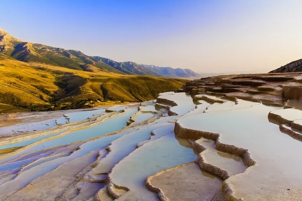
The Champagne Pool is a remarkable geothermal feature located in the Waiotapu Thermal Wonderland, near Rotorua, in the North Island of New Zealand. It is one of the most popular and visually stunning attractions in the region, drawing in numerous visitors each year.

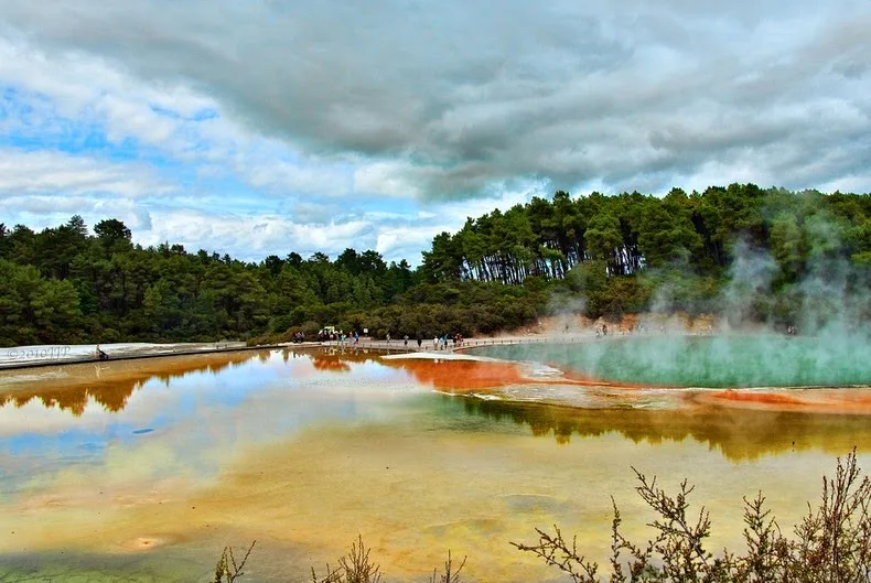
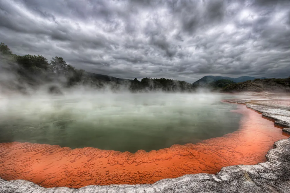
The pool itself is a large, hot spring characterized by its vibrant colors and effervescent appearance, which is reminiscent of a glass of champagne. The name “Champagne Pool” is derived from the constant release of carbon dioxide bubbles that rise to the surface, resembling the effervescence of champagne.

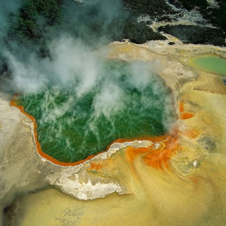
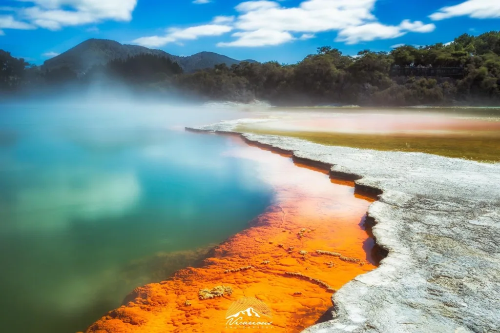
The Champagne Pool is renowned for its extraordinary geological features. It measures approximately 65 meters (213 feet) in diameter and reaches a depth of around 62 meters (203 feet). The pool’s striking hues are caused by a combination of minerals and chemicals present in the water, including gold, silver, mercury, and arsenic, which create a mesmerizing blend of vibrant orange, green, and yellow colors.

The water temperature of the Champagne Pool is consistently high, hovering around 74°C (165°F). This extreme heat is attributed to the underlying geothermal activity that occurs deep within the Earth’s crust. The surrounding area is dotted with geothermal vents and geysers, contributing to the fascinating and otherworldly ambiance of the site.

The Champagne Pool is not only visually captivating but also holds great scientific value. It is considered a rare example of a hot spring with a silica terrace, which forms due to the gradual deposition of silica-rich minerals over an extended period. The silica terrace around the pool’s edge creates a beautiful and delicate rim, adding to the pool’s unique allure.

Due to the fragile nature of the Champagne Pool and the potentially hazardous conditions of the geothermal area, visitors are required to adhere to designated walkways and viewing platforms for their safety. The pool’s scenic beauty, coupled with its geological significance, make it a must-visit attraction for nature enthusiasts, geology aficionados, and tourists seeking an awe-inspiring experience in New Zealand.

Formation and history

The Champagne Pool, like other geothermal features in the Waiotapu Thermal Wonderland, has a fascinating formation and history. Its origins can be traced back thousands of years to volcanic activity in the region.

The pool was formed as a result of hydrothermal eruptions and subsequent collapses of the land. The eruptions occurred when underground magma chambers heated groundwater, causing it to expand rapidly and create pressure. Eventually, the pressure would be released through hydrothermal eruptions, similar to geysers.

Over time, these eruptions led to the formation of a large crater-like structure, which later filled with mineral-rich water from underground hot springs. The water in the Champagne Pool is heated by the geothermal activity in the area, with volcanic heat sources located deep within the Earth’s crust.

The minerals and chemicals present in the water contribute to the unique colors and characteristics of the pool. The orange and yellow hues are attributed to the presence of antimony, while the green color comes from the abundance of colloidal sulfur. The pool’s name, “Champagne Pool,” was inspired by the constant release of carbon dioxide bubbles, which resemble the effervescence of champagne.

The Champagne Pool’s history is not limited to its formation. Over the years, the pool’s rim has undergone changes due to mineral deposits and erosion. Silica-rich minerals in the water gradually accumulate along the pool’s edge, creating the delicate silica terrace that surrounds it. This terrace is a rare feature and adds to the pool’s visual appeal.

The Waiotapu Thermal Wonderland, including the Champagne Pool, has long been revered by the indigenous Māori people of New Zealand. They consider the area sacred and have legends and stories associated with the geothermal features. Today, the site is protected and managed by authorities to preserve its natural and cultural significance.

It’s important to note that the Champagne Pool, like other geothermal features, is subject to ongoing geological processes and changes. Eruptions, subsidence, and alterations in water chemistry can occur, transforming the landscape over time. Regular monitoring and scientific studies are conducted to better understand these phenomena and ensure the safety of visitors.

As with any geological feature, the formation and history of the Champagne Pool continue to evolve, making it an intriguing subject for researchers and a captivating destination for visitors from around the world.

Geological features of the Champagne

The Champagne Pool showcases several remarkable geological features that make it a unique and visually striking natural wonder. Here are some of its notable geological characteristics:

  1. Crater-like Structure: The Champagne Pool is situated within a large, circular crater-like depression, which was formed through hydrothermal eruptions and subsequent collapses of the land. The rim of the pool is elevated and adorned with a delicate silica terrace, adding to its distinct appearance.
  2. Silica Terrace: One of the defining features of the Champagne Pool is the silica terrace that surrounds its edge. This terrace is formed by the gradual deposition of silica-rich minerals from the hot spring water over an extended period. The silica forms delicate and intricate formations, creating an exquisite rim around the pool.
  3. Vibrant Colors: The pool’s vibrant colors are a result of various minerals and chemicals dissolved in the water. The orange and yellow hues are caused by antimony, while the green coloration comes from colloidal sulfur. The combination of these colors, along with the contrasting blue water, creates a captivating visual spectacle.
  4. Constant Effervescence: The Champagne Pool gets its name from the continuous release of carbon dioxide bubbles that rise to the surface. These bubbles, resembling the effervescence of champagne, are a result of the underground hydrothermal activity, where gases escape through the water.
  5. Hot Spring and Geothermal Activity: The Champagne Pool is classified as a hot spring, characterized by its high temperature and geothermal activity. The pool’s water is heated by underground volcanic heat sources, resulting in a relatively constant temperature of around 74°C (165°F). The surrounding area also exhibits geothermal features such as steam vents and geysers, contributing to the overall geologic significance of the region.
  6. Mineral Deposits: Over time, the mineral-rich water of the Champagne Pool deposits various minerals and chemicals on its floor, creating colorful sediments. These sediments can be observed through the clear blue water, providing insights into the ongoing geological processes within the pool.

It’s important to note that the Champagne Pool, like other geothermal features, is subject to ongoing geological changes. Eruptions, subsidence, and alterations in water chemistry can occur, impacting the pool’s appearance and characteristics. Monitoring and scientific research help in understanding these dynamic processes and ensuring the preservation of this natural wonder for future generations.

Composition and temperature of the pool

The Champagne Pool’s composition and temperature are key factors that contribute to its unique characteristics and geological significance. Here’s an overview of the pool’s composition and temperature:

Composition: The water in the Champagne Pool is rich in a variety of minerals and chemicals, which impart vibrant colors and create a visually stunning spectacle. Some of the notable elements and compounds present in the pool include:

  1. Silica (SiO2): Silica is a dominant mineral in the pool’s water and is responsible for the formation of the silica terrace around the pool’s rim. The deposition of silica over time creates delicate and intricate formations.
  2. Antimony (Sb): Antimony contributes to the pool’s distinctive orange and yellow colors. It is a naturally occurring element that is dissolved in the geothermal water and precipitates out as the water cools.
  3. Colloidal Sulfur (S): Colloidal sulfur is responsible for the pool’s green coloration. It forms when hydrogen sulfide gas, which is released during the geothermal activity, reacts with oxygen in the air.
  4. Other Minerals: The Champagne Pool contains a range of other minerals, including gold, silver, mercury, and arsenic. These minerals contribute to the pool’s diverse color palette and add to its geological interest.

Temperature: The Champagne Pool is known for its high temperature, which is a result of the geothermal activity in the area. The water temperature of the pool remains relatively constant, hovering around 74°C (165°F). The intense heat is generated by volcanic heat sources deep within the Earth’s crust.

The high temperature of the water is a result of the interaction between the heated rock beneath the surface and groundwater. The water is heated by volcanic activity, where magma heats the surrounding rocks, and the heat is transferred to the groundwater. As a result, the Champagne Pool provides a vivid display of vibrant colors and constant steam due to the boiling water and continuous release of gases.

It’s worth noting that the temperature and composition of the Champagne Pool can vary slightly over time due to the dynamic nature of geothermal systems. Monitoring and scientific studies help track these changes, providing insights into the pool’s geological processes and preserving its natural beauty.

Explanation of geothermal activity in the area

The geothermal activity in the area surrounding the Champagne Pool is a fascinating result of the region’s unique geological characteristics. Here’s an explanation of the geothermal activity in the area:

  1. Tectonic Setting: The geothermal activity in the Champagne Pool area is closely linked to the tectonic setting of New Zealand. The country sits on the boundary of the Pacific Plate and the Australian Plate, which are constantly moving and interacting. This tectonic activity creates a geologically active environment, with volcanic activity and geothermal features.
  2. Volcanic System: The Champagne Pool is located within the Taupo Volcanic Zone, which is a highly active volcanic system in New Zealand. This volcanic zone is associated with the subduction of the Pacific Plate beneath the Australian Plate. As the Pacific Plate sinks into the Earth’s mantle, it generates intense heat and triggers volcanic activity in the region.
  3. Magma Chamber: Deep beneath the Earth’s surface in the Taupo Volcanic Zone, there is a magma chamber. This chamber is a reservoir of molten rock, or magma, which is the primary heat source for the geothermal activity in the area. The magma chamber heats the surrounding rocks, which in turn heat the groundwater, leading to the formation of hot springs and geothermal features like the Champagne Pool.
  4. Hydrothermal Circulation: The heat from the magma chamber drives a process called hydrothermal circulation. As groundwater seeps into the ground and comes into contact with the hot rocks, it absorbs heat and becomes heated itself. The heated water then rises to the surface through fractures and faults in the Earth’s crust, creating geothermal features such as hot springs, geysers, and mud pools.
  5. Mineral-rich Waters: The geothermal waters in the Champagne Pool area contain a variety of dissolved minerals and chemicals. These minerals are derived from the rocks that the water interacts with underground. When the heated water reaches the surface, it can deposit these minerals, creating colorful sediments and unique geological formations.
  6. Pressure and Gas Release: The geothermal activity also leads to the release of gases, such as carbon dioxide and hydrogen sulfide. These gases are produced through various chemical reactions taking place in the subsurface. The release of gases, along with the boiling of the hot water, contributes to the constant effervescence and steam seen in the Champagne Pool and other geothermal features.

The Champagne Pool is just one example of the geothermal wonders found in the area, which include geysers, mud pools, and other hot springs. The ongoing geothermal activity provides a fascinating glimpse into the dynamic forces at work beneath the Earth’s surface and creates a unique and captivating natural environment.

Impact of tourism and human activity on the Champagne Pool

The Champagne Pool, like any natural attraction, experiences both positive and negative impacts from tourism and human activity. Here’s an overview of the impacts:

Positive Impacts:

  1. Economic Benefits: Tourism brings economic benefits to the region by generating revenue and employment opportunities. Visitors who come to see the Champagne Pool contribute to the local economy through spending on accommodations, dining, transportation, and other tourist services.
  2. Cultural Exchange and Education: Tourism provides an opportunity for cultural exchange and education. Visitors can learn about the indigenous Māori culture and their connection to the geothermal features, including the Champagne Pool. This promotes cultural understanding and appreciation.
  3. Conservation Awareness: Tourism can raise awareness about the importance of environmental conservation and preservation. By experiencing the beauty of the Champagne Pool, visitors may develop a greater appreciation for natural wonders and be inspired to support conservation efforts.

Negative Impacts:

  1. Environmental Degradation: The high volume of visitors can lead to environmental degradation if not managed properly. Trampling on delicate vegetation, littering, and improper waste disposal can harm the surrounding ecosystem and impact water quality.
  2. Physical Impact: Unregulated human activity, such as stepping off designated pathways or touching the pool, can damage the fragile silica terrace, disrupt sediment deposits, and harm the overall geological integrity of the Champagne Pool.
  3. Water Contamination: Improper handling of chemicals or waste by tourists can lead to water contamination, affecting the pool’s ecosystem and potentially altering its delicate balance of minerals and chemicals.
  4. Crowding and Overwhelm: Large numbers of tourists can lead to overcrowding, especially during peak seasons, which can diminish the visitor experience and negatively impact the natural serenity of the site.

Management and Mitigation:

To mitigate the negative impacts and ensure the long-term preservation of the Champagne Pool, various management strategies are implemented:

  1. Visitor Education: Providing visitors with information about responsible behavior, such as staying on designated paths, not littering, and respecting the natural environment, can help minimize negative impacts.
  2. Infrastructure and Pathways: Constructing well-designed pathways and viewing platforms allows visitors to enjoy the pool while minimizing physical damage and protecting sensitive areas.
  3. Monitoring and Regulation: Regular monitoring of visitor numbers, environmental conditions, and water quality can help inform management decisions and ensure sustainable tourism practices are upheld.
  4. Waste Management: Implementing proper waste management systems, including garbage bins and recycling facilities, encourages visitors to dispose of waste responsibly and minimizes the risk of contamination.
  5. Controlled Access: Limiting visitor numbers or implementing timed entry systems can help manage crowds and reduce the impact of human activity on the Champagne Pool.

By implementing effective management strategies, striking a balance between tourism and conservation, and promoting responsible visitor behavior, it is possible to minimize the negative impacts while allowing people to enjoy and appreciate the natural beauty of the Champagne Pool for years to come.

Visitor experience and tourism

The Champagne Pool offers visitors a unique and awe-inspiring experience, attracting tourists from around the world. Here’s an overview of the visitor experience and tourism associated with the Champagne Pool:

  1. Scenic Beauty: The Champagne Pool’s vibrant colors, steam rising from the hot water, and the intricate silica terrace create a visually stunning sight. Visitors are captivated by the otherworldly ambiance and the natural beauty of the geothermal feature.
  2. Cultural Significance: The Champagne Pool holds cultural significance for the indigenous Māori people of New Zealand. Visitors have the opportunity to learn about the Māori culture, their traditions, and their spiritual connection to the geothermal wonders in the area.
  3. Educational Opportunities: The Champagne Pool offers educational opportunities for visitors to learn about geothermal activity, volcanic processes, and the unique geological formations associated with hot springs. Interpretive signage and guided tours provide insights into the pool’s formation, history, and scientific significance.
  4. Thermal Wonderland: The Champagne Pool is part of the larger Waiotapu Thermal Wonderland, which encompasses a wide range of geothermal features, including geysers, mud pools, and colorful pools. Visitors can explore the diverse geothermal landscape and witness the dynamic forces of nature in action.
  5. Guided Tours: Guided tours are available for visitors, providing informative commentary and ensuring a safe and enriching experience. Knowledgeable guides share geological and cultural information, enhancing the visitor’s understanding and appreciation of the Champagne Pool.
  6. Boardwalks and Viewing Platforms: To protect the fragile ecosystem and ensure visitor safety, designated boardwalks and viewing platforms are in place. These structures allow visitors to observe the Champagne Pool and its surroundings while minimizing physical impact on the environment.
  7. Sustainable Tourism: Efforts are made to promote sustainable tourism practices at the Champagne Pool. Conservation measures, waste management systems, and responsible visitor behavior are encouraged to minimize the negative impact on the pool’s ecosystem and preserve its natural integrity.
  8. Visitor Facilities: The Champagne Pool area offers visitor facilities such as parking lots, visitor centers, restrooms, and picnic areas. These amenities enhance the visitor experience and provide necessary services for a comfortable visit.

It’s important to note that the visitor experience and tourism at the Champagne Pool are managed to strike a balance between accessibility and conservation. Measures are in place to ensure the long-term preservation of the site while allowing visitors to appreciate its natural wonders.

As with any popular tourist destination, it’s advisable for visitors to plan their visit in advance, consider the environmental guidelines, and respect the rules and regulations set by park authorities. This ensures a positive and sustainable experience for everyone while safeguarding the Champagne Pool’s unique beauty for future generations.

FAQs

How deep is the Champagne Pool?

The depth of the Champagne Pool is estimated to be around 62 meters (203 feet).

Is it safe to swim in the Champagne Pool?

No, swimming is not allowed in the Champagne Pool. The high temperature of the water and its chemical composition make it unsafe for bathing or swimming.

Can you walk around the Champagne Pool?

Visitors can observe the Champagne Pool from designated boardwalks and viewing platforms. However, direct access to the pool is not permitted to protect the fragile environment and ensure visitor safety.

What causes the Champagne Pool to bubble?

The Champagne Pool constantly releases carbon dioxide bubbles, which resemble the effervescence of champagne. This bubbling is caused by the underground hydrothermal activity and the release of gases from the hot water.

How hot is the water in the Champagne Pool?

The water in the Champagne Pool maintains a relatively constant temperature of around 74°C (165°F). It is heated by the geothermal activity in the area and remains too hot for human contact.

Are there any geysers near the Champagne Pool?

Yes, there are geysers in the vicinity of the Champagne Pool. The most famous one is the Lady Knox Geyser, located nearby, which erupts daily due to a natural process facilitated by park staff.

How long does a visit to the Champagne Pool take?

The length of a visit to the Champagne Pool can vary depending on individual preferences. On average, visitors spend about 1 to 2 hours exploring the geothermal wonders of the Waiotapu Thermal Wonderland, which includes the Champagne Pool.

Can you take photographs of the Champagne Pool?

Yes, photography is permitted at the Champagne Pool. Visitors are encouraged to capture the unique colors and geological features of the pool but should be mindful not to obstruct pathways or endanger themselves or others while taking photos.

Are there any restrictions for visiting the Champagne Pool?

There are certain restrictions to ensure visitor safety and environmental conservation. These include staying on designated pathways, not touching the pool or its surroundings, and following any specific guidelines provided by park authorities.

Is the Champagne Pool accessible for individuals with disabilities?

Efforts have been made to provide accessibility to the Champagne Pool area. Accessible pathways and facilities are available for visitors with disabilities, ensuring that they can also enjoy the natural wonder of the pool.

The Badab-e Surt Terraces, Iran

Badab-e Surt Terraces, also known as Badab Soort, is a stunning natural wonder located in Mazandaran Province, Iran. It is a unique geological formation consisting of colorful mineral-rich terraces and natural springs, creating a breathtaking landscape that attracts visitors from around the world.

The name “Badab-e Surt” translates to “bubbling springs” in the local language. The terraces were formed over thousands of years as water from two distinct mineral springs flowed down the mountainside, depositing various minerals and creating striking, stepped formations. The springs are primarily composed of calcium carbonate, which gives the terraces their distinct white color, and iron oxide, which contributes to the terraces’ vibrant orange hues.

The terraces are divided into two main cascades, with the larger one measuring approximately 70 meters in height. Each terrace is a result of the accumulation of mineral deposits over time, forming small pools of vividly colored water. The contrast between the white and orange terraces, coupled with the surrounding greenery, creates a visually captivating scene.

The water in the springs is believed to have healing properties due to its high mineral content. As a result, the site has been used for centuries by locals for therapeutic purposes. People often come to Badab-e Surt Terraces to soak in the pools and enjoy the natural beauty and tranquility of the area.

To fully appreciate the beauty of Badab-e Surt Terraces, it is recommended to visit during sunrise or sunset when the colors of the terraces are enhanced by the warm light. The surrounding landscape, with its rugged mountains and lush vegetation, further adds to the allure of the site.

While Badab-e Surt Terraces have gained popularity among tourists in recent years, the remote location and limited accessibility have helped preserve its natural state. Visitors are encouraged to be respectful of the environment and adhere to any conservation guidelines in place to ensure the long-term preservation of this remarkable natural phenomenon.

In summary, Badab-e Surt Terraces are a captivating natural wonder in Iran, featuring stunning mineral-rich terraces formed over thousands of years. The unique colors, soothing springs, and picturesque surroundings make it a must-visit destination for nature lovers and photographers seeking a one-of-a-kind experience.

Geological Formation

The geological formation of Badab-e Surt Terraces is an interesting process that spans thousands of years. The terraces are the result of a combination of geological and hydrological factors.

The formation of Badab-e Surt Terraces begins with the presence of two distinct mineral springs, each containing a different combination of minerals. The first spring is rich in calcium carbonate, while the second spring contains a high concentration of iron oxide.

As water from these springs emerges from the ground, it flows downhill along the mountainside. The water carries dissolved minerals with it, and as it cascades down, it evaporates and loses some of its carbon dioxide content. This causes the minerals to precipitate and accumulate, gradually building up the terraces.

The terraces are formed in a step-like manner due to the deposition of different mineral layers. Over time, the alternating layers of calcium carbonate and iron oxide create the characteristic white and orange colors that are seen in the terraces.

The shape and formation of the terraces are also influenced by other factors, such as the slope of the mountainside and the local climate. The flow of the water and the rate of mineral deposition determine the size and shape of each terrace, resulting in the unique stepped appearance.

It’s important to note that the formation of these terraces is a delicate and slow process, taking thousands of years to develop. The ongoing hydrological processes, including the flow of water and the accumulation of minerals, continue to shape and modify the terraces to this day.

The geological significance of Badab-e Surt Terraces lies in its rarity and the intricate interplay between hydrology, mineralogy, and the local environment. It serves as a remarkable example of nature’s ability to create stunning geological formations over long periods of time.

Visitor Experience and Tourism

Visiting Badab-e Surt Terraces offers a unique and memorable experience for tourists. The natural beauty of the terraces, combined with the surrounding landscape, makes it a popular destination for nature enthusiasts, photographers, and those seeking a peaceful retreat.

Here are some key aspects of the visitor experience and tourism at Badab-e Surt Terraces:

  1. Scenic Beauty: The terraces’ vibrant colors, contrasting layers, and cascading pools create a visually captivating scene. Visitors can enjoy the stunning views and appreciate the intricate geological formations. The terraces are particularly mesmerizing during sunrise or sunset when the warm light enhances the colors.
  2. Natural Springs: The mineral-rich springs at Badab-e Surt are believed to have therapeutic properties. Many visitors come to soak in the pools and experience the alleged healing effects of the mineral water. It offers a unique opportunity to relax and rejuvenate in a natural setting.
  3. Photography: The terraces’ unique colors, patterns, and natural surroundings make it a paradise for photographers. The picturesque landscape offers endless opportunities for capturing stunning images. Photographers often visit during different times of the day to capture the terraces in varying lighting conditions.
  4. Hiking and Nature Walks: The region surrounding Badab-e Surt Terraces is characterized by scenic mountains, lush vegetation, and hiking trails. Visitors can explore the area through hiking or nature walks, taking in the fresh air and enjoying the natural beauty of the surroundings.
  5. Cultural Significance: The terraces have cultural significance for the local population. They have been used for centuries for their alleged therapeutic properties, and the site holds a special place in the traditions and folklore of the region. Visitors can learn about the local culture and traditions associated with the terraces.
  6. Conservation and Sustainability: Due to the remote location and limited accessibility, the site has managed to retain its natural state to a large extent. Efforts are made to preserve and protect the terraces and the surrounding ecosystem. Visitors are encouraged to respect the environment, follow designated trails, and adhere to any conservation guidelines in place.

It’s important to note that while tourism has increased in recent years, the site is still relatively off the beaten path. Facilities such as accommodation and amenities are limited in the immediate vicinity. Therefore, visitors should plan accordingly and be prepared for a more rustic and nature-focused experience.

Overall, visiting Badab-e Surt Terraces offers a unique blend of natural beauty, cultural significance, and outdoor activities, making it an enchanting destination for travelers seeking a memorable and immersive experience.

Comparison with other travertine terraces and similar geological formations

Badab-e Surt Terraces are indeed unique, but there are other travertine terraces and similar geological formations around the world that share certain characteristics. Here are a few notable examples for comparison:

  1. Pamukkale, Turkey: Pamukkale, located in southwestern Turkey, is perhaps the most famous travertine terrace formation globally. It features terraces of white mineral-rich deposits formed by hot springs. The white terraces of Pamukkale are visually similar to the white terraces of Badab-e Surt, but the geological processes and mineral compositions may differ.
  2. Huanglong, China: Huanglong, located in the Sichuan Province of China, is another stunning travertine terrace system. It is known for its vibrant blue and turquoise pools that form terraces. The colors and the overall visual appeal of Huanglong’s terraces provide a distinct contrast to the terraces of Badab-e Surt.
  3. Mammoth Hot Springs, Yellowstone National Park, USA: Mammoth Hot Springs in Yellowstone National Park showcases a unique collection of terraces formed by hot mineral-rich water. The terraces here are primarily composed of travertine and feature intricate formations that resemble cascading steps. Although the color palette and overall appearance differ from Badab-e Surt, they share the common feature of terraces formed by mineral deposition.
  4. Hierve el Agua, Mexico: Located in the Mexican state of Oaxaca, Hierve el Agua is a fascinating geological formation featuring “petrified waterfalls.” These formations are the result of mineral-laden springs creating cascades of mineral deposits over thousands of years. Hierve el Agua shares a similarity with Badab-e Surt in terms of the stepped terraces formed by the deposition of minerals.

While these examples showcase similar geological formations, each has its own unique characteristics, colors, and surrounding landscapes, offering distinct visitor experiences. The mineral composition, hydrological processes, and regional geology contribute to the individuality of each site, making them all remarkable natural wonders worth exploring.

Recap of the key points about Badab-e Surt Terraces

  • Badab-e Surt Terraces are located in Mazandaran Province, Iran. The name translates to “bubbling springs” in the local language.
  • The terraces are a unique geological formation resulting from the flow of two distinct mineral springs down the mountainside.
  • The terraces are composed of colorful mineral deposits, primarily calcium carbonate and iron oxide, creating striking white and orange hues.
  • The terraces form stepped formations, with small pools of vividly colored water at each level.
  • The terraces are considered a natural wonder and attract visitors from around the world.
  • The site offers a scenic and visually captivating experience, especially during sunrise or sunset.
  • The mineral-rich springs at Badab-e Surt are believed to have therapeutic properties and are used for relaxation and healing purposes.
  • Photography enthusiasts are drawn to the terraces for their unique colors and patterns.
  • The region surrounding Badab-e Surt offers opportunities for hiking, nature walks, and exploring the natural beauty of the area.
  • The terraces have cultural significance and are associated with local traditions and folklore.
  • Conservation efforts are in place to preserve and protect the terraces and the surrounding ecosystem.
  • Badab-e Surt Terraces are part of a larger group of travertine terraces found worldwide, each with its own distinct features and characteristics.

Overall, Badab-e Surt Terraces offer a breathtaking natural spectacle, where visitors can immerse themselves in the beauty of the terraces, enjoy the alleged healing properties of the mineral-rich springs, and appreciate the wonders of nature.

FAQ

Where is Badab-e Surt Terraces located?

Badab-e Surt Terraces are located in Mazandaran Province, Iran.

How were Badab-e Surt Terraces formed?

The terraces were formed over thousands of years through the flow of mineral-rich springs, which deposited minerals and created the stepped formations.

What minerals give the terraces their colors?

The terraces primarily consist of calcium carbonate, which gives them their white color, and iron oxide, which contributes to the vibrant orange hues.

Can you swim in the pools at Badab-e Surt?

Swimming is generally not allowed in the terraces, as they are considered a natural and protected site. However, visitors can soak their feet in some designated areas.

Are there any accommodations near Badab-e Surt?

Accommodations near Badab-e Surt are limited. It is recommended to stay in nearby cities such as Sari or Amol and plan a day trip to visit the terraces.

What is the best time to visit Badab-e Surt Terraces?

The terraces are best visited during sunrise or sunset when the colors are enhanced by the warm light. However, visiting during the daytime also provides a beautiful experience.

Are there any hiking trails around Badab-e Surt?

Yes, the surrounding region offers hiking trails that allow visitors to explore the natural beauty and enjoy the scenic landscapes.

Are there any entry fees to visit Badab-e Surt?

Yes, there is typically an entry fee to access the terraces. The fee helps with the maintenance and conservation of the site.

Can I bring a professional camera for photography?

Yes, photography is allowed, and the unique terraces provide excellent opportunities for capturing stunning images. However, it is advisable to check any specific guidelines or restrictions related to photography.

Are there any local legends or folklore associated with Badab-e Surt?

Yes, Badab-e Surt Terraces have cultural significance in the region, and there are local legends and folklore surrounding the site. Visitors can learn about these stories and traditions from locals or guides.

Stone Forest, China

The Stone Forest, also known as Shilin in Chinese, is a remarkable natural wonder located in the Yunnan Province of southwestern China. Renowned for its unique limestone formations, the Stone Forest is an expansive area filled with towering rock pillars, stone peaks, and intricate stone sculptures that resemble a forest made of stone, hence its name.

Covering an area of over 400 square kilometers (150 square miles), the Stone Forest is a popular tourist attraction and has been designated as a UNESCO World Heritage site. It is located approximately 78 kilometers (48 miles) southeast of Kunming, the capital city of Yunnan Province.

The stone formations in the Stone Forest are the result of geological processes that occurred over millions of years. The area was once covered by an ancient sea, and as the sea receded, the limestone deposits formed and were gradually shaped by the forces of water and erosion. The result is a surreal landscape of towering limestone pillars, some reaching heights of up to 30 meters (98 feet).

Exploring the Stone Forest allows visitors to wander through a labyrinth of stone formations, caves, and narrow pathways. The unique shapes of the limestone pillars have led to them being given imaginative names, such as “Sword Peak Pond,” “Ashima Stone,” and “Elephant Playing with Water.” These natural sculptures have inspired countless legends and folklore among the local Yi ethnic minority, who have inhabited the region for centuries.

Aside from its natural beauty, the Stone Forest is also home to a diverse range of plant and animal species. The area’s lush vegetation includes numerous ferns, orchids, and other endemic flora. Various birds, insects, and mammals can also be spotted within the forest, making it a haven for nature enthusiasts and wildlife lovers.

In addition to its scenic splendor, the Stone Forest offers visitors a glimpse into the rich cultural heritage of the region. The Yi people, one of China’s ethnic minorities, have inhabited the area for generations and have preserved their unique customs, traditions, and arts. Visitors can witness traditional Yi dances, music performances, and even participate in local festivals to experience the vibrant cultural tapestry of the Stone Forest.

Overall, the Stone Forest in China is a captivating destination that combines natural beauty, geological marvels, cultural heritage, and a sense of awe-inspiring wonder. Its unique limestone formations and rich history make it an enchanting place to explore, attracting tourists from around the world who seek to immerse themselves in its ethereal atmosphere and extraordinary landscapes.

Geological Formation and Features

The Stone Forest’s geological formation is primarily attributed to the accumulation of limestone and subsequent weathering processes. Here’s a more detailed explanation of its formation and notable features:

  1. Limestone Formation: The Stone Forest was once covered by an ancient sea around 270 million years ago during the Permian Period. Over time, the remains of marine organisms, such as shells and coral, settled at the bottom and formed layers of sediment. Through geological processes like compaction and lithification, these sediments transformed into limestone, a sedimentary rock composed mainly of calcium carbonate.
  2. Uplift and Erosion: Approximately 200 million years ago, tectonic movements caused the area to uplift, exposing the limestone deposits to the forces of erosion. The combination of water, wind, and chemical weathering gradually wore away the softer rock layers, leaving behind the distinctive karst landscape seen in the Stone Forest today.
  3. Karst Topography: The Stone Forest showcases karst topography, which is characterized by soluble rocks (in this case, limestone) being dissolved and eroded by water over time. Rainwater, containing weak carbonic acid from atmospheric carbon dioxide, seeps into cracks and fissures in the limestone, dissolving it and creating underground channels and caves. As the process continues, the land surface above can collapse, forming sinkholes and depressions.
  4. Pillars and Peaks: The most iconic feature of the Stone Forest is the numerous towering stone pillars and peaks that dot the landscape. These structures, sometimes reaching heights of 30 meters (98 feet), are the result of differential erosion. The harder limestone layers are more resistant to weathering and remain as vertical pillars, while the softer layers erode more quickly, creating the gaps and distinctive shapes seen in the rock formations.
  5. Caves and Underground Rivers: Within the Stone Forest, there are numerous caves and underground river systems that have formed through the dissolution of limestone. Some of these caves are open to visitors and offer a chance to explore the intricate network of subterranean passages and marvel at stalactites, stalagmites, and other cave formations.
  6. Natural Sculptures and Names: The unique shapes of the limestone formations have inspired imaginative names given to the rocks. Visitors can see sculptures resembling animals, plants, and other objects. For instance, the “Sword Peak Pond” resembles a forest of sword-like rocks rising from a calm pool, while the “Ashima Stone” is said to resemble a beautiful young girl from a local Yi ethnic legend.
  7. Subtropical Vegetation: The Stone Forest is also notable for its diverse subtropical vegetation. The area is rich in ferns, mosses, orchids, and other plant species that thrive in the humid and shaded environment. The lush greenery adds to the enchanting atmosphere of the Stone Forest and complements the dramatic rock formations.

The geological formation and features of the Stone Forest make it a captivating destination for geology enthusiasts, nature lovers, and curious travelers alike. Its unique karst landscape, towering stone pillars, and intricate caves combine to create a truly awe-inspiring natural wonder.

Exploration and Tourist Attractions

Exploring the Stone Forest offers visitors a range of attractions and activities that showcase the natural beauty and cultural heritage of the area. Here are some of the notable tourist attractions and experiences within the Stone Forest:

  1. Stone Forest Scenic Area: The Stone Forest Scenic Area is the main attraction within the region. It encompasses an extensive area of the stone formations, walking trails, and scenic viewpoints. Visitors can wander through the labyrinth of limestone pillars, marvel at the unique rock formations, and immerse themselves in the otherworldly atmosphere of the Stone Forest.
  2. Naigu Stone Forest: Naigu Stone Forest is a particularly scenic section within the Stone Forest. It is known for its dense concentration of towering stone peaks, deep valleys, and tranquil lakes. This section offers breathtaking vistas and picturesque spots for photography, allowing visitors to capture the grandeur of the stone formations.
  3. Lizijing Stone Forest: Lizijing Stone Forest is another popular section of the Stone Forest that features a variety of peculiar rock formations. It is renowned for its tall, slender stone pillars that resemble bamboo shoots. This area offers visitors a chance to witness the delicate and elegant beauty of the stone forest.
  4. Changhu Lake: Located within the Stone Forest Scenic Area, Changhu Lake is a serene lake surrounded by lush greenery. It provides a tranquil setting where visitors can relax, enjoy the peaceful ambiance, and appreciate the reflections of the surrounding stone formations on the water’s surface.
  5. Ethnic Cultural Performances: The Stone Forest is home to the Yi ethnic minority, who have inhabited the region for generations. Visitors can witness traditional Yi cultural performances, including dance, music, and theatrical presentations that showcase the unique customs, costumes, and art forms of the local community. These performances offer insights into the rich cultural heritage of the Stone Forest.
  6. Ethnic Villages: Exploring the nearby Yi ethnic villages allows visitors to experience the traditional lifestyle, architecture, and craftsmanship of the local community. It provides an opportunity to interact with the residents, learn about their customs, taste traditional cuisine, and purchase handcrafted souvenirs.
  7. Stone Forest Museum: The Stone Forest Museum provides a deeper understanding of the geological history, formation, and cultural significance of the Stone Forest. It exhibits a collection of fossils, minerals, and cultural artifacts, allowing visitors to delve into the scientific and cultural aspects of the region.
  8. Hiking and Nature Trails: The Stone Forest offers several hiking and nature trails that allow visitors to explore the area on foot. These trails take visitors through various sections of the stone formations, offering different perspectives and encounters with the natural beauty of the Stone Forest. Guided tours and information boards provide insights into the geological and ecological aspects of the area.
  9. Local Festivals: The Stone Forest hosts various local festivals throughout the year, providing an opportunity to witness and participate in traditional celebrations. These festivals often involve colorful ceremonies, music, dance performances, and lively cultural activities, adding to the vibrant atmosphere of the Stone Forest.

Visiting the Stone Forest offers a blend of natural wonders, cultural experiences, and outdoor activities that cater to a wide range of interests. Whether it’s exploring the surreal rock formations, immersing in local culture, or simply enjoying the tranquility of the surroundings, the Stone Forest provides a memorable and enchanting experience for tourists.

FAQ

Where is the Stone Forest located?
The Stone Forest is located in the Yunnan Province of southwestern China, approximately 78 kilometers (48 miles) southeast of Kunming, the capital city of Yunnan.

How big is the Stone Forest?
The Stone Forest covers an area of over 400 square kilometers (150 square miles), offering a vast expanse of unique limestone formations to explore.

How were the limestone formations in the Stone Forest created?
The limestone formations in the Stone Forest were formed over millions of years through the accumulation of sediment and subsequent erosion and weathering processes.

Are there guided tours available in the Stone Forest?
Yes, guided tours are available in the Stone Forest. Local guides can provide informative commentary, help navigate the area, and share interesting stories and legends associated with the stone formations.

Can visitors hike in the Stone Forest?
Yes, visitors can hike in the Stone Forest. There are hiking trails and nature paths that allow for exploration of the area on foot. Some trails offer different viewpoints and encounters with the unique rock formations.

Are there entrance fees to visit the Stone Forest?
Yes, there are entrance fees to visit the Stone Forest. The fees may vary depending on the season and whether you are a domestic or international visitor. It is recommended to check the official website or inquire at the entrance for the latest pricing information.

Can visitors visit the Stone Forest year-round?
Yes, the Stone Forest is open to visitors throughout the year. However, it’s important to note that weather conditions can vary, so it’s advisable to check the best time to visit based on personal preferences and the desired experience.

How much time is recommended to explore the Stone Forest?
The amount of time needed to explore the Stone Forest can vary depending on individual preferences and interests. However, a typical visit can range from a few hours to a full day.

Is there accommodation available near the Stone Forest?
Yes, there are accommodations available near the Stone Forest, ranging from budget guesthouses to more upscale hotels. Some visitors choose to stay overnight to fully immerse themselves in the beauty of the area.

Are there restaurants or food options in the Stone Forest?
Yes, there are restaurants and food options available within the Stone Forest Scenic Area. These establishments offer a variety of local cuisine and snacks to cater to visitors’ dining needs.

Tsingy de Bemaraha National Park, Madagascar

Tsingy de Bemaraha National Park is a unique and breathtaking natural wonder located in the western part of Madagascar. Covering an area of approximately 1,520 square kilometers (590 square miles), it was designated as a UNESCO World Heritage Site in 1990 due to its exceptional geological formations and rich biodiversity.

The name “Tsingy” originates from the Malagasy word meaning “walking on tiptoes.” This name perfectly describes the jagged limestone formations found throughout the park. These formations were created over millions of years through the process of erosion, resulting in a maze of sharp limestone pinnacles, deep canyons, and razor-sharp ridges.

The Tsingy de Bemaraha National Park consists of two major areas: the Great Tsingy and the Little Tsingy. The Great Tsingy is the larger and more accessible section, featuring towering limestone peaks reaching up to 50 meters (165 feet) high. It offers adventurous hiking trails and suspension bridges that allow visitors to explore its impressive landscapes. The Little Tsingy, as the name suggests, is a smaller area but equally stunning, with narrow canyons and limestone needles.

One of the most remarkable features of Tsingy de Bemaraha National Park is its unique ecosystem. The park is home to a wide variety of plant and animal species, many of which are endemic to Madagascar. The limestone formations provide habitats for several rare and endangered species, including several species of lemurs, reptiles, and birds. The park also has a network of underground rivers, caves, and sinkholes, adding to its ecological diversity.

Exploring Tsingy de Bemaraha National Park requires a sense of adventure and a certain level of physical fitness. Visitors can embark on guided hikes, which include climbing ladders, crossing rope bridges, and navigating narrow passages. These activities offer an adrenaline-filled experience while allowing visitors to marvel at the park’s stunning geological formations and discover its hidden gems.

Due to its remote location and challenging terrain, visiting Tsingy de Bemaraha National Park requires planning and coordination. It is advisable to hire a local guide who is familiar with the area and can ensure your safety during the exploration. Additionally, the park has limited infrastructure and accommodations, so it is essential to make arrangements in advance.

In conclusion, Tsingy de Bemaraha National Park is a geological masterpiece and an ecological treasure. Its unique limestone formations and diverse wildlife make it a must-visit destination for nature enthusiasts and adventurers seeking a one-of-a-kind experience in Madagascar.

Geology and Formation of Tsingy

The geology and formation of Tsingy de Bemaraha National Park are fascinating and are the result of millions of years of geological processes. The park’s distinctive limestone formations were shaped by a combination of erosion, water, and tectonic activity.

The foundation of Tsingy de Bemaraha National Park is composed of a layer of limestone that was deposited during the Jurassic Period, approximately 200 million years ago when Madagascar was part of the supercontinent Gondwana. This limestone layer was formed from the accumulation of the remains of marine organisms such as corals, shells, and microorganisms.

Over time, geological uplift and tectonic movements caused the limestone layer to rise, creating a plateau. The uplift was accompanied by the formation of cracks and fractures in the limestone due to stress and pressure. These cracks provided pathways for water to flow, leading to the development of an extensive underground network of rivers and caves.

The main geological process responsible for the unique formations in Tsingy de Bemaraha is karstification. Karstification occurs when water, rich in carbon dioxide, seeps through the cracks in the limestone and dissolves the rock over time. As the water dissolves the limestone, it creates underground channels, caves, and sinkholes.

The dissolution of the limestone also leads to the creation of the sharp pinnacles and ridges known as tsingy. As the water dissolves the limestone, the harder parts of the rock, such as the fossilized remains of marine organisms, are left behind, forming a durable layer called a hardpan. The softer parts of the limestone erode away, leaving behind the jagged, needle-like formations that give the park its distinctive appearance.

Erosion played a crucial role in shaping the Tsingy de Bemaraha landscape. Rainfall and surface water flowed through the cracks and crevices, carving out canyons and deepening gorges over time. Wind and chemical weathering also contributed to the shaping of the limestone formations, gradually wearing away the exposed surfaces.

The formation of Tsingy de Bemaraha National Park is an ongoing process. The erosive forces of water and wind continue to shape and modify the landscape, albeit at a slow pace. This dynamic geological environment has created a unique and stunning natural spectacle, making Tsingy de Bemaraha a remarkable and internationally recognized site.

Exploration and Tourism in Tsingy de Bemaraha National Park

Exploring Tsingy de Bemaraha National Park offers visitors a chance to witness the park’s remarkable geological formations and discover its diverse wildlife. However, due to its remote location and challenging terrain, visiting the park requires careful planning and coordination.

When visiting Tsingy de Bemaraha, it is highly recommended to hire a local guide who is knowledgeable about the area. The guides are familiar with the park’s trails and can ensure your safety during the exploration. They can also provide valuable insights into the park’s geology, flora, and fauna, enhancing your overall experience.

The park offers several hiking trails that allow visitors to navigate through the limestone formations and explore its hidden gems. The trails vary in difficulty, ranging from easy walks to more strenuous hikes that involve climbing ladders and crossing suspension bridges. These activities provide a sense of adventure and allow visitors to appreciate the park’s unique beauty up close.

One of the main attractions in Tsingy de Bemaraha National Park is the Grand Tsingy, the larger and more accessible section of the park. It offers well-marked trails and viewing platforms that provide panoramic views of the limestone pinnacles. Visitors can embark on guided hikes that take them through narrow canyons, over precarious bridges, and to stunning viewpoints.

For those seeking a more adventurous experience, the Little Tsingy offers a wilder and more challenging terrain. The trails in this area are narrower, and navigating through the sharp limestone needles requires agility and care. The Little Tsingy offers a more secluded and immersive experience, with the opportunity to discover hidden caves and crevices.

It’s important to note that exploring Tsingy de Bemaraha National Park requires a certain level of physical fitness and agility. Visitors should be prepared for hiking on uneven and steep terrain, climbing ladders, and crossing narrow bridges. Wearing sturdy and comfortable footwear is essential for traversing the sharp limestone formations safely.

Accommodations within the park are limited, and most visitors stay in nearby towns such as Bekopaka. These towns offer basic guesthouses and camping facilities. It is advisable to make arrangements in advance and check for the availability of accommodations and services.

As with any natural area, it is crucial to practice responsible tourism when visiting Tsingy de Bemaraha National Park. Visitors should follow the park’s regulations, stay on designated trails, and avoid touching or damaging the delicate limestone formations. It is also important to respect the wildlife and their habitats by observing from a distance and refraining from disturbing or feeding the animals.

In conclusion, Tsingy de Bemaraha National Park offers a unique and unforgettable experience for nature enthusiasts and adventure seekers. The park’s stunning geological formations, diverse wildlife, and challenging trails make it a remarkable destination worth exploring with the proper planning and guidance.

FAQ

How do I get to Tsingy de Bemaraha National Park?

Tsingy de Bemaraha National Park is located in western Madagascar. To reach the park, you can fly into Antananarivo, the capital city of Madagascar, and then take a domestic flight or travel by road to the town of Morondava. From Morondava, you can arrange transportation, such as a 4×4 vehicle, to reach the park.

Do I need a guide to visit Tsingy de Bemaraha National Park?

It is highly recommended to hire a local guide when visiting Tsingy de Bemaraha National Park. The guides are familiar with the park’s trails, geology, and wildlife. They ensure your safety and enhance your experience by providing valuable insights and information.

What is the best time to visit Tsingy de Bemaraha National Park?

The best time to visit Tsingy de Bemaraha National Park is during the dry season, which typically runs from April to November. During this period, the weather is generally drier, making it easier to navigate the trails and explore the park’s limestone formations. However, it’s always a good idea to check the weather conditions before your trip.

Are there accommodations available inside the park?

There are limited accommodations inside Tsingy de Bemaraha National Park. Most visitors stay in nearby towns such as Bekopaka, where you can find basic guesthouses and camping facilities. It is advisable to make reservations in advance to ensure availability.

What should I pack for a visit to Tsingy de Bemaraha National Park?

When visiting the park, it is recommended to pack sturdy and comfortable footwear for hiking on uneven terrain. Additionally, pack lightweight and breathable clothing suitable for the tropical climate, insect repellent, sunscreen, a hat, and a reusable water bottle. Don’t forget your camera to capture the stunning landscapes!

Are there any age restrictions for visiting Tsingy de Bemaraha National Park?

There are no specific age restrictions for visiting the park. However, it’s important to consider the physical demands of the activities involved, such as hiking and climbing ladders. Visitors should assess their own fitness levels and capabilities, especially for more challenging trails.

Is it possible to see wildlife in Tsingy de Bemaraha National Park?

Yes, Tsingy de Bemaraha National Park is home to a diverse array of wildlife, including several species of lemurs, reptiles, and birds. Hiring a guide increases your chances of spotting wildlife and learning about the different species that inhabit the park.

Are there any safety precautions I should take while visiting Tsingy de Bemaraha National Park?

While visiting the park, it’s important to follow the guidance of your guide and stay on designated trails. The limestone formations can be sharp and treacherous, so it’s crucial to be cautious and avoid touching or damaging them. Additionally, be aware of your surroundings, carry necessary supplies, and stay hydrated during your hikes.

How long should I plan to spend in Tsingy de Bemaraha National Park?

The duration of your visit depends on your interests and the activities you wish to undertake. A minimum of two to three days is recommended to explore the park and experience its main attractions. However, if you want to delve deeper into the park’s wilderness and undertake more extensive hikes, you may need additional time.

Carborundite

Carborundum, also known as silicon carbide (SiC), is a crystalline compound composed of silicon and carbon. It was first discovered in the late 19th century and has since become an important material with various industrial applications. One particular form of carborundum is carborundite.

Carborundite refers to a synthetic compound of silicon carbide that is primarily used as an abrasive material. It is created through the process of combining silicon dioxide and petroleum coke at extremely high temperatures, typically in an electric resistance furnace. The resulting product is a hard, crystalline material with excellent hardness and thermal conductivity.

Due to its exceptional hardness, carborundite is widely used as an abrasive in applications such as grinding, cutting, polishing, and sanding. It is commonly utilized in the manufacturing and machining industries for tasks like sharpening tools, shaping and finishing metal surfaces, and removing unwanted material.

Carborundite’s hardness also makes it suitable for applications that require wear resistance and durability. It is employed in the production of wear-resistant parts, such as ceramic bearings, mechanical seals, and cutting tools. Additionally, carborundite is used in the production of refractory materials, which are capable of withstanding high temperatures and harsh environments. These refractories find application in industries such as metallurgy, ceramics, and glass manufacturing.

Another significant characteristic of carborundite is its high thermal conductivity. This property makes it valuable for thermal management applications, including heat sinks and electronic components that require efficient heat dissipation.

Furthermore, carborundite has found use in the field of electronics, particularly in the semiconductor industry. It is used as a substrate material for electronic devices and as an abrasive in the production of silicon wafers for semiconductors.

Overall, carborundite, with its exceptional hardness, thermal conductivity, and other desirable properties, plays a crucial role in numerous industrial applications. Its versatility and durability have made it an essential material for various manufacturing processes, contributing to the advancement of numerous industries.

Geological Formation of Carborandite

Carborundite, or silicon carbide, is not a naturally occurring mineral. It is a synthetic compound produced through industrial processes. However, silicon carbide does have natural counterparts that are formed through geological processes.

Natural silicon carbide minerals are typically found in certain types of metamorphic rocks, specifically in high-temperature and high-pressure environments. The most common natural form of silicon carbide is called moissanite, which is a rare mineral discovered in meteorites and found in limited quantities in certain regions of the Earth.

The geological formation of natural silicon carbide involves the following processes:

  1. Metamorphism: Silicon carbide forms under conditions of high temperature and pressure during metamorphic events. Metamorphism occurs when pre-existing rocks are subjected to intense heat and pressure deep within the Earth’s crust or during tectonic events such as mountain building.
  2. Carbon-rich Environments: Silicon carbide formation requires a carbon-rich environment. The presence of carbonaceous materials, such as graphite or organic matter, in the rocks undergoing metamorphism provides a source of carbon for the reaction.
  3. High-Temperature Reactions: Under high temperatures and pressures, silicon dioxide (SiO2) and carbonaceous materials react to form silicon carbide. This reaction can be represented by the chemical equation:SiO2 + 3C → SiC + 2COIn this reaction, silicon dioxide combines with carbon to produce silicon carbide and carbon monoxide gas.
  4. Crystallization: The newly formed silicon carbide crystallizes within the rock matrix as the temperature and pressure conditions allow. The resulting silicon carbide crystals can range in size and occur in various forms, depending on the specific conditions of formation.

It’s important to note that while natural silicon carbide minerals are found in geological formations, the industrial production of carborundite involves a different process. Synthetic carborundite is created by combining silicon dioxide and petroleum coke at extremely high temperatures in an electric resistance furnace. This synthetic production method allows for the controlled creation of carborundite with specific properties and compositions for various industrial applications.

Physical Properties of Carborandite

Carborundite, or silicon carbide (SiC), possesses several notable physical properties that make it valuable for various industrial applications. Here are some key physical properties of carborundite:

  1. Hardness: Carborundite is an extremely hard material. On the Mohs scale of mineral hardness, it has a hardness rating of 9-9.5, making it one of the hardest known substances. This hardness contributes to its excellent abrasive properties and wear resistance.
  2. Crystal Structure: Carborundite crystallizes in a variety of crystal structures, including hexagonal, rhombohedral, and cubic forms. The crystal structure influences the material’s physical and chemical properties.
  3. Color: The color of carborundite varies depending on impurities and crystal structure. Pure carborundite is usually colorless or appears as a pale yellow or greenish tint. Impurities can give it shades of blue, brown, or black.
  4. Density: The density of carborundite typically ranges from 3.0 to 3.2 grams per cubic centimeter (g/cm³). This relatively high density contributes to its solid and robust nature.
  5. Thermal Conductivity: Carborundite exhibits high thermal conductivity, meaning it efficiently conducts heat. This property makes it useful for applications where heat dissipation is crucial, such as heat sinks and electronic components.
  6. Melting Point: The melting point of carborundite is approximately 2,830 degrees Celsius (5,126 degrees Fahrenheit). Its high melting point enables it to withstand extreme temperatures, making it suitable for high-temperature applications.
  7. Electrical Conductivity: Carborundite can conduct electricity, but its conductivity is significantly lower than that of metals. It is considered a semiconductor material and finds application in the electronics industry, particularly in high-temperature and high-power devices.
  8. Chemical Stability: Carborundite is highly chemically stable, especially at high temperatures. It is resistant to acids, alkalis, and oxidation, which makes it suitable for use in harsh chemical environments.

These physical properties of carborundite contribute to its wide range of applications, including abrasives, refractories, semiconductor devices, ceramics, and more. Its hardness, thermal conductivity, and stability make it a versatile material capable of withstanding demanding conditions.

Occurrence and Distribution of Carborandite

Carborundite, or silicon carbide (SiC), does not occur naturally in significant quantities. It is primarily a synthetic compound produced through industrial processes. However, natural silicon carbide minerals do exist in limited quantities and are known as moissanite.

Moissanite is a rare mineral that was first discovered in 1893 in a meteorite crater in Arizona, United States. It is also found in other meteorites and has been identified in a few terrestrial locations. However, natural moissanite is extremely scarce and does not occur in large enough quantities for significant industrial use.

As for synthetic carborundite, it is produced worldwide in large quantities for industrial applications. The manufacturing process involves combining silica (silicon dioxide) and petroleum coke at high temperatures in electric resistance furnaces. Synthetic carborundite can be tailored to specific requirements, such as particle size, purity, and composition, making it suitable for various industries.

The distribution of carborundite production facilities is widespread, with manufacturing plants located in different countries across the globe. Major producers include the United States, China, Russia, and countries in Europe.

While natural moissanite is rare and not commercially significant, the synthetic production of carborundite ensures a stable and reliable supply for industrial purposes. Its versatility and desirable properties have led to its wide application in industries such as abrasives, refractories, electronics, ceramics, and more.

Petrogenesis of Carborandite

Carborundite, or silicon carbide (SiC), is not a mineral that forms through typical petrogenetic processes. It is a synthetic compound produced industrially by combining silica (silicon dioxide) and petroleum coke at high temperatures.

In natural geologic settings, silicon carbide can form as a mineral known as moissanite, but its occurrence is extremely rare and typically associated with meteorite impacts. Moissanite is not a product of typical petrogenesis or rock-forming processes.

Petrogenesis refers to the formation and evolution of rocks through geological processes. The formation of rocks involves various processes such as crystallization from magma or lava, sedimentation and lithification of sediments, and metamorphism under high temperatures and pressures. These processes give rise to the diverse range of minerals and rocks found in the Earth’s crust.

However, carborundite, as a synthetic compound, is not a product of natural petrogenesis. It is specifically manufactured through an industrial process that involves the combination of silica and petroleum coke in electric resistance furnaces at high temperatures.

Therefore, the petrogenesis of carborundite lies in its synthetic production rather than in natural geologic processes.

Geological Significance and Research Applications

While carborundite, or synthetic silicon carbide (SiC), does not have direct geological significance in terms of its natural occurrence, it does have important applications and research implications in the field of geology. Here are a few ways in which carborundite is significant in geology:

  1. Laboratory Experiments: Carborundite is used as an abrasive material in laboratory settings for cutting, grinding, and polishing geological samples. It allows geologists to prepare thin sections of rocks and minerals for microscopic analysis, aiding in the study of their mineralogical composition, textures, and structures.
  2. High-Temperature and High-Pressure Experiments: Carborundite’s resistance to high temperatures and pressures makes it valuable for experimental studies simulating extreme geological conditions. Geologists can use carborundite as a material in high-temperature furnaces or pressure vessels to recreate and investigate geological processes such as metamorphism, magma generation, or deep Earth conditions.
  3. Refractory Materials: Carborundite’s ability to withstand high temperatures and its resistance to chemical reactions make it suitable for manufacturing refractory materials used in high-temperature industrial processes. These refractories find application in various geological industries, including metallurgy, ceramics, and glass production.
  4. Research on Meteorites: Natural moissanite, a rare form of silicon carbide found in meteorites, has significant implications for studying extraterrestrial materials and planetary processes. Research involving the analysis of moissanite grains helps scientists understand the formation and evolution of meteorites, the early solar system, and the conditions in which they originated.
  5. Semiconductor and Electronics Research: Carborundite is a valuable material in the field of semiconductor research. Its properties, such as high thermal conductivity and wide bandgap, make it suitable for electronic devices and high-power applications. Researchers explore the potential of carborundite in developing advanced electronic components and power devices for various applications, including geophysical instrumentation and environmental monitoring.

It’s important to note that carborundite’s significance in geology primarily lies in its use as an experimental material and its contributions to scientific research rather than its natural occurrence. Its properties and applications enable geologists and researchers to study geological processes, simulate extreme conditions, and investigate various aspects of Earth and planetary sciences.

Uses

Carborundite, or silicon carbide (SiC), has a wide range of applications across various industries due to its unique properties. Here are some of the main uses of carborundite:

  1. Abrasives: Carborundite is widely used as an abrasive material. Its extreme hardness makes it effective for cutting, grinding, and polishing hard surfaces. It is utilized in abrasive products such as grinding wheels, sandpapers, and abrasive powders for metalworking, stone cutting, and surface finishing applications.
  2. Refractories: Carborundite’s high temperature resistance and chemical stability make it valuable for manufacturing refractory materials. These materials are used in industries where high temperatures and harsh conditions are encountered, such as in furnaces, kilns, and reactors for metal smelting, glass production, and cement manufacturing.
  3. Ceramics: Carborundite is employed in the production of advanced ceramics. Its high hardness, thermal conductivity, and resistance to heat and chemical corrosion make it suitable for manufacturing ceramic components used in high-temperature environments, electrical insulation, and wear-resistant applications.
  4. Semiconductor Devices: Carborundite’s semiconductor properties, including its wide bandgap and high-temperature stability, make it valuable in the production of semiconductor devices. It is used in power electronics, high-voltage rectifiers, and high-frequency applications. Carborundite-based devices are utilized in areas such as energy conversion, electric vehicles, and renewable energy systems.
  5. Heat Dissipation: Due to its excellent thermal conductivity, carborundite is used in heat sinks and heat exchangers for efficient heat dissipation. It helps dissipate heat generated by electronic components, such as computer chips, power modules, and LED devices.
  6. Wear-resistant Parts: Carborundite’s hardness and resistance to wear and abrasion make it suitable for manufacturing wear-resistant parts. It is used in the production of mechanical seals, bearings, cutting tools, and other components that require high durability and resistance to wear.
  7. Environmental and Energy Applications: Carborundite is utilized in various environmental and energy-related applications. It is used in catalytic converters for reducing emissions from vehicles, as a filter media in water treatment systems, and in solar energy systems for its optical properties and durability.
  8. Research and Development: Carborundite is employed in laboratories and research facilities for experiments, simulations, and studies involving high temperatures, extreme pressures, and material testing. It serves as a material for geological research, high-temperature experiments, and other scientific investigations.

These are just a few examples of the diverse applications of carborundite. Its unique combination of hardness, thermal conductivity, chemical stability, and semiconductor properties make it a valuable material in industries ranging from manufacturing and electronics to energy and environmental sectors.

Summary of key points

  • Carborundite is a synthetic form of silicon carbide, not a naturally occurring mineral.
  • It is produced by combining silica (silicon dioxide) and petroleum coke at high temperatures in electric resistance furnaces.
  • Carborundite is primarily used as an abrasive material for grinding, cutting, polishing, and sanding.
  • Its exceptional hardness, with a Mohs hardness rating of 9-9.5, makes it suitable for wear-resistant applications.
  • Carborundite has high thermal conductivity, making it valuable for thermal management applications such as heat sinks.
  • It is resistant to chemicals, acids, alkalis, and oxidation, providing stability in harsh environments.
  • Carborundite finds applications in various industries, including manufacturing, machining, electronics, ceramics, and refractories.
  • Natural silicon carbide minerals, known as moissanite, are extremely rare and mainly found in meteorites.
  • Carborundite’s synthetic production allows for controlled properties and compositions tailored to specific industrial needs.
  • It is used in laboratory experiments, high-temperature and high-pressure research, refractories, semiconductor devices, and wear-resistant parts.
  • Carborundite has significance in geology for studying rocks and minerals, simulating extreme conditions, and investigating meteorites and planetary processes.
  • Its unique combination of properties makes it valuable for a wide range of applications in various industries.

FAQs

  1. What is carborundite?

Carborundite, also known as silicon carbide (SiC), is a synthetic compound produced by combining silica (silicon dioxide) and petroleum coke at high temperatures. It is primarily used as an abrasive material and has various other industrial applications.

  1. Is carborundite a naturally occurring mineral?

No, carborundite is not a naturally occurring mineral. It is a synthetic compound created through industrial processes. However, natural silicon carbide minerals, such as moissanite, do exist in limited quantities.

  1. What are the main properties of carborundite?

Carborundite is known for its extreme hardness (Mohs hardness of 9-9.5), high thermal conductivity, chemical stability, and resistance to wear and abrasion. It also has semiconductor properties and can withstand high temperatures and harsh environments.

  1. What are the applications of carborundite?

Carborundite is used as an abrasive material in grinding, cutting, and polishing applications. It is also used in refractories, ceramics, semiconductor devices, heat sinks, wear-resistant parts, and various other industrial applications.

  1. How is carborundite manufactured?

Carborundite is manufactured by heating a mixture of silica and petroleum coke in electric resistance furnaces at high temperatures. The reaction between the two materials results in the formation of silicon carbide.

  1. Is carborundite toxic or hazardous?

Carborundite itself is generally considered to be inert and non-toxic. However, during manufacturing processes, exposure to dust or particulate matter should be avoided, as inhalation of fine particles may cause respiratory irritation.

  1. Can carborundite be recycled?

Yes, carborundite can be recycled. It can be processed and reused in various applications, such as the production of new abrasive products or as a component in refractories and ceramics.

  1. What are the alternatives to carborundite?

Some alternatives to carborundite as an abrasive material include aluminum oxide, diamond, and cubic boron nitride (CBN). The choice of abrasive material depends on the specific application and desired characteristics.

  1. Are there any environmental concerns associated with carborundite?

Carborundite itself is chemically stable and does not pose significant environmental concerns. However, the manufacturing process may involve energy-intensive operations, and proper waste management and emission control measures need to be implemented to minimize environmental impacts.

  1. Can carborundite be used in jewelry?

While carborundite itself is not commonly used in jewelry, its natural counterpart, moissanite, is used as a gemstone. Moissanite, a naturally occurring silicon carbide mineral, possesses optical properties that make it suitable as a diamond substitute in jewelry.

Purnululu National Park or Bungle Bungle Range

Purnululu National Park, also known as the Bungle Bungle Range, is a spectacular natural landmark located in the Kimberley region of Western Australia. It is renowned for its unique sandstone formations, distinctive beehive-shaped domes, and stunning landscapes that have captivated visitors from around the world.

The national park covers an area of approximately 239,723 hectares (591,416 acres) and was inscribed as a UNESCO World Heritage site in 2003, recognizing its outstanding universal value. The name “Purnululu” comes from the local Indigenous Kija language, which means “sandstone” and is a fitting tribute to the remarkable geological features found in the area.

The Bungle Bungle Range stands as the centerpiece of the national park, featuring striking orange and black striped domes that rise up to 250 meters (820 feet) above the surrounding landscape. These beehive formations were formed over millions of years through a process of erosion, with alternating bands of sandstone and layers of dark biological crusts creating the unique coloration.

Exploring Purnululu National Park offers visitors a chance to witness the raw beauty of nature. The park is home to diverse flora and fauna, including rare and endemic species. Among the notable wildlife found in the area are the black-flanked rock wallabies, reptiles, and a variety of bird species.

The park provides a range of activities for visitors to engage with its natural wonders. Hiking trails wind through the stunning landscapes, allowing adventurers to explore the remarkable formations up close. The most famous hike is the 7.4-kilometer (4.6-mile) circular trail known as the Picaninny Gorge Walk, which takes you deep into the heart of the Bungle Bungle Range.

For those seeking aerial views, scenic helicopter flights are available, providing a breathtaking perspective of the park’s expansive vistas and intricate rock formations. Sunset and sunrise views over the Bungle Bungle Range are particularly mesmerizing, casting a warm glow over the domes and enhancing their striking colors.

Visitors to Purnululu National Park are encouraged to respect the cultural significance of the area to the local Indigenous communities. The traditional owners, the Kija and Jaru people, have a deep spiritual connection to the land, and their ancient rock art can be found in several locations throughout the park.

In summary, Purnululu National Park, with its iconic Bungle Bungle Range, offers a unique and awe-inspiring experience for nature lovers and adventurers. Its ancient sandstone formations, vibrant colors, and rich biodiversity make it a truly remarkable destination in the Australian outback.

Geological Formation

The geological formation of Purnululu National Park’s Bungle Bungle Range is a fascinating story that spans millions of years. The distinctive beehive-shaped domes and striking striped patterns are the result of a complex process involving erosion and unique geological conditions.

The Bungle Bungle Range is composed primarily of sandstone, specifically a type known as the Devonian-age quartz sandstone. The sandstone was deposited over 350 million years ago, during a time when the region was covered by a shallow sea. Layers of sand were gradually deposited and compressed over time, forming the foundation of the range.

The unique appearance of the Bungle Bungle domes is attributed to the subsequent processes of erosion and weathering. The domes are formed from the erosion of the sandstone layers, which have varying degrees of hardness and resistance to weathering. The more resistant layers create the distinct beehive-shaped formations, while softer layers erode more quickly, creating valleys and gullies between the domes.

Over millions of years, wind and water have played a crucial role in shaping the Bungle Bungle Range. The wind carries fine particles of sand and acts as an abrasive agent, slowly eroding the sandstone and creating the rounded shapes of the domes. Water, particularly during heavy rainfall, has also contributed to the erosion process, carving out gorges and channels between the domes.

The remarkable striped patterns seen on the domes are a result of the interplay between different types of biological crusts and the underlying sandstone layers. The darker stripes are created by cyanobacteria, a type of photosynthetic bacteria that grows on the surface of the sandstone. These bacteria produce dark pigments and bind the sand particles together, forming a protective crust. The lighter-colored stripes are areas where the crust is absent, exposing the bare sandstone.

The geological formation of the Bungle Bungle Range is a testament to the incredible power of natural forces over vast periods of time. It is a unique and awe-inspiring landscape that showcases the beauty and intricacy of the Earth’s geological processes.

Sandstone Dome Structures

Sandstone dome structures are geological formations characterized by rounded or dome-shaped features made primarily of sandstone rock. These formations often exhibit distinct layers or bands of sedimentary rock, which can vary in color, texture, and composition.

The formation of sandstone dome structures typically involves several geological processes. It begins with the deposition of sand particles, usually in a marine or terrestrial environment, over an extended period. Over time, the accumulated sand becomes compacted and cemented together by minerals, forming solid rock known as sandstone.

Erosion plays a significant role in shaping the sandstone into dome-like structures. Weathering agents such as wind, water, and chemical reactions gradually wear away the softer or less resistant layers of sandstone, leaving behind harder and more resistant layers. This differential erosion creates the characteristic domed shape, with the more resistant layers forming the upper part of the dome.

The layers or bands within sandstone dome structures are often the result of variations in sedimentation. Changes in environmental conditions, such as fluctuations in water depth, flow velocity, or sediment supply, can lead to different types of sediments being deposited at different times. As a result, distinct layers with different compositions, colors, or grain sizes can be observed within the sandstone domes.

Sandstone domes can vary in size, ranging from a few meters to several hundred meters in diameter. The domes may occur individually or in clusters, forming unique landscapes and landmarks in various parts of the world.

One notable example of sandstone dome structures is the Bungle Bungle Range in Purnululu National Park, as mentioned earlier. The beehive-shaped domes of the Bungle Bungle Range are composed of Devonian-age quartz sandstone and showcase distinctive banding patterns due to the presence of cyanobacteria and different sedimentary layers.

Sandstone dome structures are not only visually striking but also provide important insights into the geological history of a region. They serve as a record of ancient environments, sedimentation patterns, and the forces of erosion that have shaped our planet over millions of years.

Discussion on the iconic orange and black striped patterns on the sandstone

The iconic orange and black striped patterns seen on the sandstone in places like the Bungle Bungle Range in Purnululu National Park are a remarkable natural phenomenon that adds to the unique beauty of these geological formations. These stripes are a result of the interplay between various factors, including the composition of the sandstone, mineral deposits, and biological processes.

The orange color of the stripes in the sandstone is primarily due to iron oxide, also known as hematite. Hematite is a common mineral found in sandstone, and its presence gives the rock its distinctive orange hue. Over time, as the sandstone weathers and erodes, the iron oxide becomes exposed, intensifying the orange color.

The black stripes, on the other hand, are created by a thin biological crust composed of cyanobacteria. These cyanobacteria are photosynthetic microorganisms that colonize the surface of the sandstone. They secrete a dark pigment to protect themselves from the harsh sunlight and desiccation. This dark pigment, combined with the sand particles, creates the black coloration in the sandstone stripes.

The cyanobacterial crust serves an important ecological function as well. It helps bind the sand particles together, increasing the stability and resistance of the sandstone to erosion. The crust acts as a protective layer, preventing the underlying sandstone from being easily eroded by wind and water.

The formation of these striped patterns is a result of the alternating layers of sandstone and biological crust. As the sandstone weathers, the exposed layers of sandstone and cyanobacterial crust create a visual contrast, resulting in the striking orange and black stripes that are so characteristic of these formations.

It is worth noting that the formation of these patterns takes a significant amount of time, with millions of years of weathering, erosion, and biological processes involved. The result is a visually captivating display that showcases the intricate and dynamic nature of the Earth’s geological and biological systems.

The orange and black striped patterns on the sandstone in places like the Bungle Bungle Range are not only aesthetically appealing but also serve as a reminder of the incredible processes that have shaped our planet over vast periods of time. They contribute to the overall uniqueness and splendor of these geological formations, attracting visitors from all around the world to witness their beauty firsthand.

Geological composition and characteristics of the domes

The domes found in the Bungle Bungle Range of Purnululu National Park are primarily composed of sandstone, specifically a type known as Devonian-age quartz sandstone. The sandstone in this region has distinctive characteristics that contribute to the formation of the beehive-shaped domes.

The sandstone in the Bungle Bungle Range was deposited over 350 million years ago during the Devonian Period. It consists of fine to medium-grained quartz sand particles that were originally derived from the erosion of older rocks. These sand particles were transported and deposited in a shallow marine environment, eventually compacting and cementing together to form the sandstone.

The domes themselves are created through a combination of erosion and weathering processes. The sandstone layers within the Bungle Bungle Range vary in hardness and resistance to erosion. Some layers are more resistant and compacted, while others are softer and less consolidated. This differential erosion over millions of years has resulted in the formation of the distinct beehive-shaped domes.

The erosion processes involve wind, water, and chemical weathering. Windblown sand acts as an abrasive agent, slowly wearing away the softer sandstone layers and sculpting the domes into their rounded shapes. Water, particularly during intense rainfall events, has played a crucial role in carving out gorges, channels, and valleys between the domes.

The unique orange and black striped patterns seen on the sandstone domes are a result of additional factors. As mentioned earlier, the orange color is primarily due to the presence of iron oxide (hematite) within the sandstone. The black stripes are created by a thin biological crust composed of cyanobacteria that colonize the sandstone’s surface. These contrasting colors contribute to the visual appeal and recognition of the Bungle Bungle Range.

The sandstone domes in the Bungle Bungle Range can reach heights of up to 250 meters (820 feet) and exhibit intricate details and textures on their surfaces. They are an incredible testament to the power of geological processes and the immense timescales over which they operate.

Overall, the geological composition of the domes in the Bungle Bungle Range is predominantly quartz sandstone, shaped by erosion, weathering, and the presence of unique coloration and patterns. These characteristics combine to create a truly awe-inspiring and distinct natural landscape in Purnululu National Park.

Theories about the origin of the different colors

The origin of the different colors observed in sandstone formations, including the orange and black colors found in the Bungle Bungle Range, can be attributed to various factors. While there may be different theories proposed, the primary explanations involve mineral content, chemical reactions, and biological processes.

  1. Mineral Content: The presence of certain minerals within the sandstone can contribute to its coloration. For example, iron oxide, specifically hematite, is commonly found in sandstone and can impart an orange or reddish color. The iron oxide minerals may have been deposited during the formation of the sandstone or introduced through subsequent processes like groundwater percolation.
  2. Chemical Reactions: Chemical reactions taking place within the sandstone can also influence its color. Oxidation, for instance, can occur when iron minerals in the sandstone react with oxygen in the air or water. This can lead to the development of reddish or orange hues.
  3. Biological Processes: In some cases, the presence of biological organisms can contribute to the colors observed in sandstone formations. Cyanobacteria, for example, are photosynthetic microorganisms that colonize the surface of the sandstone. They produce pigments that can range from green to black, contributing to the dark-colored stripes seen in certain sandstone formations.

It is important to note that these factors often interact with each other, leading to the intricate and varied colors observed in sandstone formations. The specific combination of mineral content, chemical reactions, and biological processes can vary depending on the geological history and environmental conditions of a particular region.

In the case of the Bungle Bungle Range, the orange coloration is primarily attributed to the presence of iron oxide, while the black stripes are a result of the cyanobacterial crust that forms on the sandstone surfaces.

Understanding the origin of colors in sandstone formations requires a comprehensive analysis of the specific geological and environmental factors at play in each location. By studying the mineralogy, geochemistry, and biology of sandstone formations, scientists can gain valuable insights into the processes that have shaped these natural wonders over time.

Overview of the cultural significance of Purnululu National Park to the indigenous people

Purnululu National Park, including the Bungle Bungle Range, holds significant cultural and spiritual importance to the Indigenous people of the region, particularly the Kija and Jaru communities. The park is situated on the traditional lands of these Aboriginal groups, and it is an integral part of their cultural heritage and connection to the land.

For the Indigenous people, Purnululu National Park is a place of deep spiritual significance and holds stories and ancestral connections that have been passed down through generations. It is a living cultural landscape that encompasses sacred sites, rock art, and ceremonial grounds, representing the rich cultural traditions and history of the Kija and Jaru people.

The traditional owners have a profound understanding of the land, its resources, and the ecological relationships within it. They possess a wealth of knowledge about the plants, animals, and natural features of the area, which has been passed down orally over thousands of years. Purnululu National Park serves as a cultural classroom, where the Indigenous people continue to teach and learn from the land.

Rock art is one of the significant cultural elements found within the park. These ancient artworks, painted on the sandstone walls, depict stories, creation narratives, and the spiritual beliefs of the Indigenous communities. They provide a glimpse into the cultural practices, ceremonies, and Dreamtime stories that have shaped the identity and worldview of the Kija and Jaru people.

The management of Purnululu National Park involves close collaboration between the traditional owners and the Western Australian government. Indigenous rangers play a crucial role in the park’s management, contributing their cultural knowledge and traditional land management practices to ensure the preservation of the park’s cultural and natural values.

Visitors to Purnululu National Park are encouraged to respect the cultural significance of the area and to adhere to the guidelines and restrictions put in place by the traditional owners. By engaging in cultural tours and interpretation programs led by Indigenous guides, visitors can gain a deeper appreciation for the land’s cultural significance and the ongoing connection of the Indigenous people to their ancestral lands.

Preserving the cultural heritage of Purnululu National Park is vital not only for the Indigenous communities but also for the broader understanding and appreciation of Australia’s rich Indigenous cultures. The park serves as a bridge between the past and the present, highlighting the enduring traditions, spirituality, and wisdom of the Kija and Jaru people.

Overview of activities and experiences available for visitors

Purnululu National Park offers a range of activities and experiences for visitors, allowing them to explore and appreciate the natural and cultural wonders of the park. Here is an overview of some of the activities and experiences available:

  1. Bushwalking and Hiking: Purnululu National Park provides several marked walking tracks that allow visitors to explore the park on foot. The most popular trail is the 7.4-kilometer (4.6-mile) return hike into Cathedral Gorge, where you can witness stunning natural amphitheaters and towering rock formations. Other trails include Echidna Chasm, Mini Palms, and Piccaninny Creek.
  2. Scenic Flights: One of the best ways to appreciate the grandeur and vastness of Purnululu National Park is through a scenic flight. Helicopter or light plane flights provide breathtaking aerial views of the Bungle Bungle Range, allowing visitors to witness the iconic striped domes from a unique perspective.
  3. Cultural Tours: Indigenous-led cultural tours provide an opportunity to learn about the rich cultural heritage of the area from the traditional owners. Indigenous guides share their knowledge, stories, and Dreamtime legends, offering insights into the spiritual and cultural significance of the land.
  4. Camping: Purnululu National Park offers several campgrounds, allowing visitors to immerse themselves in the natural surroundings. The park has basic facilities, including toilets and picnic areas. Camping permits are required and can be obtained online or from the park’s visitor center.
  5. Photography: Purnululu National Park is a photographer’s paradise, with its striking landscapes, unique rock formations, and vibrant colors. Whether capturing the striped domes, the rugged gorges, or the play of light and shadow, photographers will find endless opportunities to capture stunning images.
  6. Wildlife Spotting: The park is home to a variety of wildlife, including wallabies, goannas, bird species, and bats. Visitors can observe and appreciate the diverse flora and fauna that inhabit the park’s unique ecosystems.
  7. Stargazing: Purnululu National Park’s remote location and lack of light pollution make it an excellent spot for stargazing. On clear nights, visitors can marvel at the sparkling night sky, taking in the beauty of the stars and constellations.

It’s important to note that some activities may require permits, and certain areas of the park may have restricted access to protect the cultural and natural values. It is advisable to check with the park authorities or visitor center for up-to-date information, permits, and any safety considerations before planning your visit.

Visiting Purnululu National Park offers a chance to connect with nature, witness awe-inspiring landscapes, learn about Indigenous culture, and create unforgettable experiences in one of Australia’s most remarkable destinations.

10 FAQs

Where is Purnululu National Park located?

Purnululu National Park is located in the Kimberley region of Western Australia, approximately 250 kilometers (155 miles) south of Kununurra.

How do I get to Purnululu National Park?

The park can be accessed by road via the Great Northern Highway. From the highway, a 53-kilometer (33-mile) unsealed road leads to the park entrance. 4WD vehicles are recommended.

What is the best time to visit Purnululu National Park?

The park is generally accessible from April to November when the weather is cooler and rainfall is minimal. The peak season is during the dry months of May to September when the temperatures are more moderate.

Are there camping facilities in Purnululu National Park?

Yes, the park offers basic camping facilities at Kurrajong, Walardi, and Bellburn campgrounds. Camping permits are required and can be obtained online or from the park’s visitor center.

Are there guided tours available in Purnululu National Park?

Yes, there are Indigenous-led cultural tours available in the park, providing insights into the local Indigenous culture and history. These tours can be arranged through the park’s visitor center or local tour operators.

Can I fly over Purnululu National Park?

Yes, scenic flights over the Bungle Bungle Range are a popular option. Helicopter and light plane flights provide stunning aerial views of the park’s unique landscapes and rock formations.

Are there hiking trails in Purnululu National Park?

Yes, there are several marked walking trails in the park, including the Cathedral Gorge, Echidna Chasm, Mini Palms, and Piccaninny Creek walks. These trails offer opportunities to explore the park’s natural wonders on foot.

Are there facilities like toilets and picnic areas in the park?

Yes, the park has basic facilities such as toilets, picnic areas, and viewing platforms at key locations within the park. However, it is important to note that facilities are limited due to the park’s remote location.

What is the wildlife like in Purnululu National Park?

The park is home to a variety of wildlife, including wallabies, goannas, bird species, and bats. Visitors can observe and appreciate the diverse flora and fauna that inhabit the park’s unique ecosystems.

Can I see the famous orange and black striped domes in Purnululu National Park?

Yes, the iconic orange and black striped domes of the Bungle Bungle Range are a prominent feature of Purnululu National Park. Visitors can explore and witness these unique rock formations up close.

Selenite

Selenite is a beautiful and versatile mineral that belongs to the gypsum mineral family. It is composed of hydrous calcium sulfate and is known for its transparent to translucent appearance. Selenite crystals often exhibit a pearly or glass-like luster and have a unique fibrous or columnar structure. The name “selenite” is derived from the Greek word for “moon” due to its moon-like glow when polished or exposed to light.

One of the fascinating characteristics of selenite is its softness. It has a Mohs hardness of 2, which means it can be easily scratched with a fingernail. Despite its fragility, selenite is still highly valued for its aesthetic appeal and spiritual properties.

Selenite is commonly found in evaporite deposits, where it forms through the evaporation of ancient saltwater bodies. It can be found in various parts of the world, including Mexico, Morocco, Brazil, the United States, and Poland.

The translucent nature of selenite allows light to pass through its crystal structure, giving it a unique glow. This property makes it a popular choice for decorative purposes, such as gemstone carvings, lamps, and other ornamental objects. Selenite’s distinctive appearance and soft, delicate texture make it a sought-after mineral in the world of crystal enthusiasts, collectors, and energy healers.

In addition to its visual appeal, selenite is known for its metaphysical properties. It is often associated with clarity, purification, and spiritual connection. Many believe that selenite has the ability to cleanse and recharge other crystals, making it a popular choice for crystal healing and meditation practices. It is also thought to promote a sense of calmness and mental clarity, making it a valuable tool for relaxation and stress relief.

Due to its softness, selenite should be handled with care to avoid scratching or damaging its delicate structure. It is recommended to store selenite in a protective container or wrap it in a soft cloth to prevent accidental breakage.

Overall, selenite is a captivating mineral that combines visual beauty with spiritual and metaphysical properties. Whether used for decorative purposes or spiritual practices, selenite continues to fascinate people with its unique characteristics and alluring glow.

Formation of Selenite

Selenite forms through a process known as sedimentary precipitation in evaporite deposits. Here is a step-by-step explanation of the formation of selenite:

  1. Source of Calcium and Sulfate: The formation of selenite begins with the presence of calcium and sulfate ions in the surrounding environment. These ions are typically derived from the weathering of rocks containing calcium and sulfur compounds.
  2. Evaporation: Selenite commonly forms in areas where there is a high concentration of dissolved minerals in water bodies. In arid or semi-arid regions, such as desert environments or ancient seabeds, water often becomes trapped in shallow basins or depressions. As the water evaporates under the influence of heat and dry climate, the concentration of dissolved minerals increases.
  3. Supersaturation: As evaporation continues, the concentration of calcium and sulfate ions in the remaining water becomes so high that it exceeds their solubility limit. This results in supersaturation, where the water is unable to hold the dissolved minerals in solution.
  4. Crystal Nucleation: With the onset of supersaturation, the excess calcium and sulfate ions start to come together and form tiny crystals. These crystals act as nucleation sites for further crystal growth.
  5. Crystal Growth: As the supersaturated water continues to evaporate, the selenite crystals grow by the addition of more calcium and sulfate ions onto their surfaces. The growth process is often slow, allowing the crystals to develop intricate and elongated fibrous or columnar structures.
  6. Sedimentary Deposition: Over time, the selenite crystals settle and accumulate on the bottom of the water body or on existing sediments. The combination of crystal growth and sedimentation leads to the formation of thick layers or beds of selenite.
  7. Diagenesis: With the burial of the sediments over geologic time, the selenite crystals undergo diagenesis, which involves processes like compaction and cementation. This solidifies the sedimentary layers and transforms the loose crystals into a cohesive rock known as gypsum.
  8. Tectonic Activity and Exhumation: In some cases, tectonic forces and geological processes uplift the sedimentary rocks containing selenite to the Earth’s surface. Erosion and weathering then expose the selenite-bearing rocks, making them accessible for collection or mining.

It’s important to note that selenite can also form as a secondary mineral through the alteration of other calcium-bearing minerals in the presence of sulfate-rich fluids. However, the most common and abundant occurrence of selenite is in evaporite deposits formed through the process described above.

Crystal Structure

Selenite has a crystal structure that belongs to the monoclinic system. The crystal lattice of selenite is formed by the repeated arrangement of its constituent atoms and ions.

In selenite, the basic building blocks are calcium (Ca^2+) ions and sulfate (SO4^2-) ions. The calcium ions are surrounded by six water molecules, forming what is known as a coordination complex. These water molecules are loosely bound to the calcium ion and can be easily lost or gained, contributing to the relatively soft and fragile nature of selenite.

The sulfate ions in selenite consist of one sulfur atom bonded to four oxygen atoms. The sulfate groups are interconnected and form chains that extend along the crystallographic b-axis. These chains are connected to each other through hydrogen bonds with the water molecules associated with the calcium ions.

The arrangement of these ions and water molecules gives selenite its characteristic fibrous or columnar crystal habit. The fibers or columns can be elongated and exhibit parallel or radiating growth patterns. This growth pattern is responsible for the striations often observed on the surface of selenite crystals.

Selenite crystals are typically transparent to translucent, allowing light to pass through and giving them a unique glow when illuminated. This property is a result of the crystal structure and the arrangement of atoms and ions, which allows light to be transmitted through the crystal lattice with minimal scattering or absorption.

It’s worth noting that selenite crystals can also occur as twinned crystals, where two or more crystals are intergrown in a specific orientation. Twinning can produce complex and symmetrical patterns, adding to the aesthetic appeal of selenite specimens.

Overall, the crystal structure of selenite contributes to its delicate appearance, transparency, and unique growth patterns, making it a highly sought-after mineral for both aesthetic and metaphysical purposes.

Physical Properties

Selenite possesses several distinctive physical properties. Here are the key characteristics of selenite:

  1. Color: Selenite is usually colorless or white. It may also exhibit pale shades of yellow, orange, or light brown due to impurities present in the crystal lattice.
  2. Transparency: Selenite is transparent to translucent, allowing light to pass through its crystal structure. Thicker specimens may appear more translucent than transparent.
  3. Luster: Selenite crystals have a vitreous (glass-like) or pearly luster. When polished or exposed to light, they can exhibit a beautiful and glowing appearance.
  4. Crystal Habit: Selenite commonly occurs as prismatic or tabular crystals. The crystals can be elongated and exhibit a fibrous or columnar structure, often forming clusters or aggregates. It can also occur as massive granular or earthy forms.
  5. Cleavage: Selenite has perfect cleavage in one direction, which means it can be easily cleaved or split into thin, flat sheets. This cleavage is a result of the crystal structure and contributes to the fragility of selenite.
  6. Hardness: Selenite has a relatively low hardness on the Mohs scale, ranging from 2 to 2.5. This means it is quite soft and can be easily scratched by harder minerals or even by a fingernail.
  7. Streak: The streak of selenite is white, which means that when the mineral is rubbed against a streak plate or unglazed porcelain, it leaves a white powdery mark.
  8. Density: The density of selenite ranges from approximately 2.2 to 2.3 grams per cubic centimeter (g/cm³), which is relatively low compared to many other minerals.
  9. Solubility: Selenite is soluble in water, meaning it can dissolve when exposed to moisture or immersed in water. This solubility is due to the presence of calcium and sulfate ions, which can easily dissociate in water.
  10. Fluorescence: Selenite can exhibit fluorescence under ultraviolet (UV) light. It may fluoresce in various colors, including white, yellow, or blue, depending on the impurities present in the crystal.

These physical properties contribute to the unique appearance and behavior of selenite. Its transparency, luster, and delicate crystal structure make it a visually appealing mineral for decorative and ornamental purposes. Additionally, the softness and solubility of selenite should be taken into consideration when handling and storing specimens to prevent damage.

Occurrence and Distribution

Selenite is found in various locations around the world. It is primarily associated with evaporite deposits, which are formed through the evaporation of saline water in arid or semi-arid environments. Here are some notable occurrences and distributions of selenite:

  1. Mexico: One of the most famous and significant sources of selenite is Naica in the state of Chihuahua, Mexico. The Naica Mine is known for its massive selenite crystals, some of which are among the largest in the world, reaching several meters in length. These giant crystals are found in a hot, humid, and mineral-rich cave system located deep within the mine.
  2. Morocco: Morocco is another major producer of selenite. The region of Tafilalt, particularly near the towns of Erfoud and Ouarzazate, is renowned for its selenite deposits. Moroccan selenite often occurs in clear, transparent crystals that are highly valued by collectors.
  3. United States: Selenite can be found in several states across the United States. Notable locations include the White Sands National Monument in New Mexico, where large gypsum dunes and crystalline forms of selenite are abundant. Other states with selenite deposits include Oklahoma, Utah, Nevada, and California.
  4. Brazil: In Brazil, selenite deposits can be found in various regions, including Minas Gerais and Rio Grande do Sul. These deposits often yield high-quality transparent crystals that are sought after by collectors.
  5. Poland: The Wieliczka Salt Mine in Poland is famous for its selenite formations. The mine has been in operation for centuries and is now a popular tourist destination due to its impressive salt chambers adorned with selenite crystals and other salt-related formations.
  6. Other Countries: Selenite is also found in other countries, although to a lesser extent. It can be encountered in countries such as Spain, Italy, Germany, Australia, China, and Canada.

It’s important to note that selenite can form in various geological settings, not just in evaporite deposits. It can occur as a secondary mineral resulting from the alteration of other calcium-bearing minerals, or in hydrothermal veins associated with volcanic activity.

The distribution of selenite is largely influenced by the presence of suitable geological conditions for its formation, such as evaporative environments or the presence of calcium-rich rocks. The unique combination of geological processes, climate, and local chemistry determines the occurrence and quality of selenite deposits in different regions worldwide.

Uses of Selenite

  1. Decorative and Ornamental Purposes: Selenite’s translucent appearance and pearly luster make it popular for decorative purposes. It is commonly carved into various shapes, such as spheres, hearts, wands, and other figurines. Selenite lamps and candle holders are also sought after for their ethereal glow when illuminated.
  2. Crystal Healing and Energy Work: Selenite is highly regarded in the metaphysical and spiritual community for its healing properties. It is believed to have a purifying and cleansing effect on the aura and energy fields. Selenite is often used during meditation, energy healing sessions, and chakra balancing practices to promote calmness, clarity, and spiritual connection.
  3. Charging and Cleansing Other Crystals: Selenite is known for its ability to cleanse and recharge other crystals. It is often used to remove negative energies and impurities from crystals and gemstones, helping to restore their natural vibrations and properties. Placing other crystals on a selenite charging plate or in close proximity to selenite is a common practice in crystal healing.
  4. Jewelry: Selenite is occasionally used in the creation of jewelry pieces. Although it is a relatively soft mineral, it can be crafted into pendants, earrings, and bracelets. Selenite jewelry is treasured for its delicate beauty and metaphysical properties.
  5. Education and Research: Selenite, as a mineral, is studied and used in educational and research settings. Geologists and mineral enthusiasts examine selenite specimens to understand crystallography, mineral formation, and the geological processes associated with evaporite deposits. Selenite can also be used as a reference mineral for identifying other gypsum-related minerals.
  6. Industrial Applications: Gypsum, the mineral group to which selenite belongs, has various industrial applications. Gypsum is widely used in the construction industry for making plasterboard, drywall, and other building materials. It is also used in agriculture as a soil conditioner and fertilizer additive to improve soil structure and nutrient availability.

Selenite Varieties and Forms

Selenite can occur in different varieties and forms, each with its own unique characteristics. Here are some notable varieties and forms of selenite:

  1. Satin Spar: Satin Spar is a fibrous variety of selenite characterized by its silky and satin-like appearance. It often exhibits a fibrous texture with parallel or radiating fibers that give it a silky sheen. Satin Spar selenite is commonly used for decorative purposes, such as carved figurines or polished specimens.
  2. Desert Rose: Desert Rose is a unique form of selenite that forms in desert environments with high concentrations of gypsum. It typically appears as rosette-shaped clusters of intergrown selenite crystals. The crystals are often sandblasted or weathered, giving them a distinctive rose-like appearance. Desert Rose selenite is sought after by collectors for its aesthetic value.
  3. Fishtail Selenite: Fishtail Selenite, also known as Angel Wing Selenite, is characterized by its fan-shaped or wing-like crystal formations. The crystals are often flat and elongated, resembling the shape of a fish’s tail or angel wings. Fishtail Selenite is popular among crystal enthusiasts and is used for energy work and spiritual practices.
  4. Gypsum Flower: Gypsum Flower is a form of selenite that displays intricate and delicate formations resembling flowers or feathery clusters. It is formed through the slow precipitation of mineral-rich water in caves or other underground environments. Gypsum Flower formations are highly valued for their intricate beauty.
  5. Window Pane Selenite: Window Pane Selenite, also known as Maria Glass, is a transparent and colorless variety of selenite. It has a high degree of transparency, allowing light to pass through almost like a window. Window Pane Selenite is often used for metaphysical purposes, such as scrying or meditation practices.
  6. Selenite Blades: Selenite Blades are thin, tabular crystals of selenite with sharp edges. They often occur in groups or clusters, forming delicate and translucent sheets or layers. Selenite Blades are popular for their aesthetic appeal and are commonly used in crystal grids or energy healing practices.
  7. Selenite Rosettes: Selenite Rosettes are rounded or disc-shaped formations of intergrown selenite crystals. They often exhibit radial or concentric patterns, resembling a flower or rosette. Selenite Rosettes are highly sought after by collectors for their unique and symmetrical appearance.

These are just a few examples of the different varieties and forms of selenite. Each variety showcases the fascinating diversity and beauty of this mineral, adding to its appeal in both aesthetic and metaphysical realms.

Collecting and Caring for Selenite

Collecting selenite can be an enjoyable and rewarding hobby. Here are some tips for collecting and caring for selenite specimens:

  1. Locating Specimens: Selenite specimens can be found in various locations, such as mines, caves, or desert environments. Research and exploration of known selenite-rich areas can help you find specimens. Joining local mineral or rockhounding clubs can provide valuable insights and opportunities for collecting.
  2. Permission and Regulations: Before collecting selenite specimens, ensure that you have the necessary permissions and comply with local laws and regulations. Some collecting sites may require permits or have restrictions in place to protect the environment or property rights.
  3. Safety Precautions: When collecting selenite, prioritize your safety. Wear appropriate protective gear such as gloves, eye protection, and sturdy footwear. Be cautious of unstable terrain, sharp edges, and potential hazards in mining areas or caves.
  4. Tools for Collecting: Basic tools for collecting selenite may include a rock hammer, chisel, pry bars, or small shovels. These tools can help you safely extract specimens from the surrounding rock or soil.
  5. Handling and Storage: Selenite is a relatively soft mineral, so it’s important to handle specimens with care to prevent damage or breakage. When handling selenite, avoid applying excessive pressure or dropping specimens. It’s advisable to store selenite in a padded container or wrap it in a soft cloth to protect it from scratches or impacts.
  6. Display and Lighting: Selenite’s translucent nature allows it to display its beauty when illuminated. Consider displaying your selenite specimens in well-lit areas or using lighting techniques to accentuate their glow and enhance their visual appeal.
  7. Environmental Considerations: Selenite is sensitive to moisture and humidity. It is advisable to store selenite specimens in a dry environment to prevent deterioration or unwanted changes in its physical properties. Exposure to prolonged moisture or high humidity can cause selenite to lose its luster, become dull, or even dissolve over time.
  8. Cleaning and Maintenance: Selenite is a relatively low-maintenance mineral. Avoid using water or harsh chemicals to clean selenite, as it is soluble in water. Instead, use a soft brush or compressed air to remove dust or debris. If necessary, gently wipe the surface with a dry, soft cloth.
  9. Avoiding Sunlight: Prolonged exposure to direct sunlight can cause selenite to fade or become brittle over time. To preserve its color and structural integrity, avoid placing selenite specimens in direct sunlight for extended periods.

By following these tips, you can enjoy collecting selenite specimens while ensuring their longevity and beauty. Remember to always respect collecting sites, adhere to regulations, and practice responsible collecting.

Selenite in Art and Architecture

Selenite, with its unique properties and aesthetic appeal, has been used in various forms of art and architecture throughout history. Here are some notable examples of how selenite has been incorporated into artistic and architectural creations:

  1. Sculptures and Carvings: Selenite’s translucent nature and softness make it a suitable material for carving intricate sculptures and decorative objects. Artists have utilized selenite to create figurines, statues, relief carvings, and ornamental pieces. The smooth texture and natural glow of selenite lend an ethereal and elegant quality to these artworks.
  2. Lighting Fixtures: Selenite’s ability to transmit light makes it an ideal material for creating lighting fixtures. Selenite lamps, chandeliers, and sconces are popular choices due to their soft and diffused illumination. When illuminated, selenite emits a warm and calming glow, creating a soothing ambiance in interior spaces.
  3. Architectural Details: Selenite has been incorporated into architectural designs as decorative elements. Its delicate and translucent appearance adds a touch of elegance to walls, ceilings, and columns. Selenite panels or slabs have been used as decorative coverings, creating a subtle play of light and shadow.
  4. Religious and Spiritual Art: Selenite’s metaphysical properties have made it a favored material in religious and spiritual art. It has been used in the creation of altars, prayer beads, and sacred objects. Selenite’s purity and association with spiritual connection make it a meaningful choice for artists and worshippers.
  5. Stained Glass Substitute: Selenite’s natural transparency has led to its use as a substitute for stained glass in certain applications. Thin sheets of selenite can be carved or etched with intricate designs, allowing light to pass through and creating a luminous effect reminiscent of stained glass windows.
  6. Museums and Exhibitions: Selenite specimens, particularly those with exceptional size or quality, are often displayed in museums and exhibitions as natural works of art. Their delicate and captivating beauty attracts the attention of visitors and showcases the wonders of the mineral world.

Selenite’s versatility and aesthetic qualities have made it a sought-after material for artists, architects, and designers. Its unique ability to transmit light, coupled with its delicate appearance, creates a captivating visual experience. Whether used as a standalone material or combined with other elements, selenite adds a touch of elegance and spirituality to art and architectural creations.

FAQs

What is the chemical composition of selenite?

Selenite is a form of gypsum, and its chemical formula is CaSO4·2H2O. It consists of calcium sulfate dihydrate, which means it contains calcium, sulfur, oxygen, and water molecules.

How does selenite form?

Selenite typically forms in evaporite environments when saline water evaporates, leaving behind gypsum deposits. It can also form as a secondary mineral through the hydration of other calcium-bearing minerals or in hydrothermal veins associated with volcanic activity.

What is the hardness of selenite?

Selenite has a relatively low hardness of around 2 on the Mohs scale. It is quite soft and can be easily scratched with a fingernail or a copper penny.

Is selenite soluble in water?

Yes, selenite is soluble in water. If exposed to water or high humidity for prolonged periods, it can slowly dissolve or undergo structural changes. This is why it is important to store and handle selenite specimens in dry environments.

Can selenite be found in gem-quality crystals?

While selenite is not typically considered a gemstone, it can occur in transparent and high-quality crystals suitable for use in jewelry. These crystals are often faceted or polished to enhance their beauty.

What are some common impurities found in selenite?

Selenite can contain various impurities that affect its color and transparency. Common impurities include iron, manganese, and organic matter, which can give selenite different shades of color, ranging from white to pale yellow, gray, or even brown.

How does selenite’s optical properties contribute to its appearance?

Selenite exhibits a unique property called “pearlescence” or “schiller effect.” When light interacts with the internal crystal structure of selenite, it creates a shimmering or iridescent effect, similar to the play of colors seen in pearls.

Is selenite associated with any specific geological environments?

Selenite is primarily associated with evaporite environments, where saline water evaporates and deposits gypsum minerals. It is commonly found in association with other evaporite minerals such as halite (rock salt) and anhydrite.

Can selenite be fluorescent?

Yes, under certain conditions, selenite can exhibit fluorescence. It may fluoresce under ultraviolet (UV) light, emitting a soft glow in various colors, such as blue, green, or orange.

Are there any famous selenite localities or deposits?

One of the most famous selenite localities is the Naica Mine in Chihuahua, Mexico, which is renowned for its giant selenite crystals. Other notable localities include Morocco (Erfoud and Ouarzazate regions), the White Sands National Monument in New Mexico, and the Wieliczka Salt Mine in Poland.

Jade

Jade is a mineral that is highly prized for its beauty and has been treasured for centuries in many cultures around the world. It is actually composed of two distinct minerals: jadeite and nephrite. Both jadeite and nephrite are classified as silicate minerals, which means they are primarily composed of silicon and oxygen.

Jadeite is the rarer and more valuable of the two minerals. It is a sodium and aluminum-rich pyroxene mineral with a complex chemical composition. Jadeite is known for its vibrant green color, but it can also occur in other colors such as white, yellow, brown, and lavender. The most sought-after type of jadeite is the Imperial Jade, which is a rich emerald green color.

Nephrite, on the other hand, is a calcium and magnesium-rich amphibole mineral. It is usually found in shades of green, but it can also be white, grey, or black. Nephrite jade is generally less translucent than jadeite and has a softer and more fibrous texture.

Jade has been used for centuries in various forms of art, jewelry, and decorative objects. It holds great cultural and historical significance in many societies, particularly in East Asia, where it is considered a symbol of nobility, purity, and longevity. In China, jade has been revered as the “stone of heaven” for over 4,000 years and is associated with virtues such as wisdom, harmony, and protection.

It’s important to note that the term “jade” is sometimes used more broadly to include other green-colored gemstones or materials, such as serpentine or aventurine, which may resemble true jade in appearance but have different mineral compositions. However, the true jade minerals are jadeite and nephrite.

Importance in jewelry and ornamental objects

Jade holds significant importance in the realm of jewelry and ornamental objects due to its unique beauty, cultural significance, and historical legacy. Here are some key reasons why jade is highly valued in this context:

  1. Beauty and Aesthetics: Jade’s vibrant green color and smooth, lustrous appearance make it visually striking and highly desirable for jewelry and ornamental purposes. Its natural translucency allows light to penetrate the stone, giving it a glowing and ethereal quality.
  2. Cultural and Historical Significance: Jade has deep cultural and historical roots in many civilizations, particularly in East Asia. It has been used for centuries to create exquisite jewelry pieces, sculptures, and decorative objects. Its association with nobility, spirituality, and symbolism makes it highly revered and sought after.
  3. Craftsmanship and Artistry: Jade’s durability and workability make it a favored material for skilled artisans to showcase their craftsmanship. It can be carved, sculpted, and polished into intricate designs, from delicate pendants and beads to elaborate statues and ceremonial objects. The craftsmanship involved in creating jade jewelry and ornamental pieces is often considered a fine art.
  4. Investment and Collectibility: High-quality jade, especially Imperial Jadeite, has been recognized as a valuable gemstone and a sound investment. Fine jade jewelry and ornamental objects can appreciate in value over time, particularly when they possess exceptional color, clarity, and craftsmanship. Collectors and enthusiasts worldwide are drawn to the rarity and historical significance of fine jade pieces.

Overall, jade’s importance in jewelry and ornamental objects lies in its aesthetic appeal, cultural significance, symbolism, and the meticulous craftsmanship involved in creating exquisite pieces. Its enduring popularity ensures that jade remains a highly sought-after gemstone and material for both personal adornment and artistic expression.

Geological Formation of Jade

Jade, specifically jadeite and nephrite, forms through different geological processes. Here’s an overview of the geological formation of jade:

  • Jadeite Formation: Jadeite is primarily formed in subduction zones where tectonic plates converge. It originates from the metamorphism of rocks rich in aluminum, such as serpentinite and basaltic rocks. During subduction, these rocks are subjected to high temperatures and pressures deep within the Earth’s crust, causing the minerals within them to undergo chemical changes. The process of metasomatism occurs, where fluids rich in silica and other elements infiltrate the rock, leading to the formation of jadeite. The presence of sodium-rich fluids is crucial for the formation of jadeite.
Jadeite
  • Nephrite Formation: Nephrite forms through a different geological process. It is commonly found in metamorphic rock formations, such as serpentinite, amphibolite, or greenschist. Nephrite is a product of the alteration of other minerals, particularly actinolite and tremolite, which are part of the amphibole mineral group. These minerals undergo recrystallization and transformation under intense pressure and temperature conditions, resulting in the formation of nephrite.
Nephrite

Both jadeite and nephrite can be found in association with other minerals and rocks, and their formation is closely tied to the geological history of the region. The presence of specific geological conditions, such as the right temperature, pressure, and mineral composition, is necessary for jade formation. It often takes millions of years for the geological processes to occur and for jade to be created.

It’s important to note that the specific geological formations and occurrences of jadeite and nephrite can vary across different regions of the world. For example, jadeite is more commonly found in Myanmar (formerly Burma), while nephrite is abundant in regions like China, New Zealand, Canada, and Russia.

The geological formation of jade is a complex process that involves metamorphism, alteration, and the interaction of various minerals and fluids over long periods. These geological factors contribute to the unique properties and characteristics of jade, making it a highly prized and valuable mineral.

Composition and structure

The composition and structure of jade differ depending on whether it is jadeite or nephrite.

  1. Jadeite Composition and Structure: Jadeite is a pyroxene mineral with a complex chemical composition. Its chemical formula is NaAlSi2O6. This formula indicates that jadeite contains sodium (Na), aluminum (Al), silicon (Si), and oxygen (O). However, jadeite can also contain traces of other elements, such as iron, chromium, and manganese, which contribute to its color variations.

Jadeite has a crystalline structure, specifically belonging to the monoclinic crystal system. Its crystal structure consists of chains of linked silicon-oxygen tetrahedra. These chains are interconnected by aluminum and sodium ions, creating a three-dimensional framework. The arrangement of atoms within the crystal lattice gives jadeite its characteristic physical and optical properties.

  1. Nephrite Composition and Structure: Nephrite is a type of amphibole mineral. Its chemical composition is more variable than jadeite but is generally represented by the formula Ca2(Mg,Fe)5Si8O22(OH)2. This formula indicates that nephrite contains calcium (Ca), magnesium (Mg), iron (Fe), silicon (Si), oxygen (O), and hydroxyl (OH) groups.

Nephrite has a fibrous or felted structure, composed of interlocking mineral fibers. These fibers are primarily composed of calcium, magnesium, and silicon. The fibrous nature of nephrite gives it a characteristic toughness and durability.

Both jadeite and nephrite are silicate minerals, meaning they are composed primarily of silicon and oxygen. They have dense and tightly packed atomic structures, contributing to their durability and resistance to breakage. The specific chemical compositions and crystal structures of jadeite and nephrite contribute to their unique physical properties, such as color, translucency, hardness, and toughness, which make them highly valued in jewelry and ornamental objects.

Types of jade minerals

There are two main types of jade minerals: jadeite and nephrite. Let’s take a closer look at each type:

  1. Jadeite: Jadeite is the rarer and more valuable type of jade. It is a sodium and aluminum-rich pyroxene mineral. Jadeite can occur in various colors, but the most highly prized is the vivid and intense green known as Imperial Jade. Other colors of jadeite include white, yellow, brown, lavender, and black. Jadeite can also exhibit translucency, which enhances its visual appeal. It is harder and denser than nephrite.
  2. Nephrite: Nephrite is a calcium and magnesium-rich amphibole mineral. It is more commonly found and less expensive than jadeite. Nephrite is typically green, but it can also occur in white, grey, and black colors. It has a fibrous and felt-like structure, giving it a characteristic toughness and durability. Nephrite is generally less translucent than jadeite and has a softer texture.

It’s worth noting that within these two main types, there can be variations and subtypes based on color, quality, and specific geographic origins. For example, specific varieties of jadeite, such as “Lavender Jadeite” or “Apple Green Jadeite,” may be highly sought after for their unique hues. Similarly, different regions may have their own names for particular nephrite varieties, such as “Hetian Jade” from China or “Canadian Jade” from Canada.

It’s important to distinguish genuine jade minerals (jadeite and nephrite) from other green-colored gemstones or materials that may be referred to as “jade” in a broader sense, such as serpentine or aventurine. While these materials may resemble true jade in appearance, they have different mineral compositions and properties.

Physical and Chemical Properties of Jade

The physical and chemical properties of jade, specifically jadeite and nephrite, contribute to their unique characteristics and desirability. Here are the key properties of jade:

Physical Properties:

  1. Color: Jade can exhibit a wide range of colors, including various shades of green, white, yellow, brown, lavender, and black. The intensity and quality of color can greatly influence the value of jade.
  2. Transparency: Jade can vary in transparency from opaque to translucent. The finest jade specimens are highly translucent, allowing light to pass through and giving the stone a desirable glow.
  3. Hardness: Jade is relatively hard, but the hardness differs between jadeite and nephrite. Jadeite has a Mohs hardness of around 6.5 to 7, which is similar to that of quartz. Nephrite is slightly softer, ranging from 6 to 6.5 on the Mohs scale.
  4. Toughness: Jade, particularly nephrite, is renowned for its toughness. It has interlocking mineral fibers that give it a high resistance to breakage and chipping.
  5. Density: Both jadeite and nephrite have a relatively high density. Jadeite has a density ranging from 3.25 to 3.36 g/cm³, while nephrite has a slightly lower density ranging from 2.9 to 3.03 g/cm³.

Chemical Properties:

  1. Composition: Jadeite is a sodium and aluminum-rich pyroxene mineral with the chemical formula NaAlSi2O6. Nephrite is a calcium and magnesium-rich amphibole mineral with the composition Ca2(Mg,Fe)5Si8O22(OH)2.
  2. Stability: Jade is chemically stable and resistant to most chemical agents. It is not easily affected by acids, alkalis, or exposure to normal environmental conditions.
  3. Refractive Index: Jadeite has a refractive index ranging from approximately 1.66 to 1.67, while nephrite has a slightly lower refractive index ranging from 1.60 to 1.62. The refractive index affects the stone’s brilliance and light interaction.
  4. Cleavage: Both jadeite and nephrite exhibit poor to absent cleavage, meaning they do not have distinct planes of weakness along which the minerals tend to break.

These physical and chemical properties contribute to the durability, beauty, and desirability of jade. Its toughness, high density, and resistance to breakage make it suitable for carving, jewelry making, and ornamental objects. The unique colors, translucency, and luster of jade add to its aesthetic appeal.

Major jade-producing regions worldwide

Jade is found in various regions around the world, but some areas are particularly renowned for their jade deposits and production. Here are some of the major jade-producing regions worldwide:

  1. Myanmar (Burma): Myanmar has a long history of jade mining and is known for its high-quality jadeite. The region of Kachin State, specifically the area around Hpakant, produces some of the world’s finest jadeite, including the highly prized Imperial Jade.
  2. China: China has been a significant producer and consumer of jade for centuries. The region of Xinjiang, particularly the Hotan area, is known for producing nephrite jade, including the renowned Hetian Jade. Other notable jade-producing regions in China include Guangxi, Liaoning, and Inner Mongolia.
  3. Guatemala: The Motagua River Valley in Guatemala is a notable source of jadeite. The country is known for its vibrant green jadeite, often referred to as “Guatemalan Jade,” which is highly valued in the international market.
  4. Russia: Russia has substantial deposits of nephrite jade, particularly in the region of Siberia. The Sayan Mountains in eastern Siberia are known for their nephrite deposits, and the region produces a significant amount of high-quality nephrite jade.
  5. Canada: Canada is a notable producer of nephrite jade, particularly in British Columbia. The province’s Jade City is famous for its nephrite jade deposits, and Canadian jade is known for its beautiful green color and quality.
  6. New Zealand: New Zealand has significant nephrite jade deposits, known locally as pounamu or greenstone. The South Island of New Zealand, specifically the West Coast and the Arahura River, is renowned for its pounamu production.
  7. United States: The United States has jade deposits in various regions. Notable sources include California, Wyoming, and Alaska. In California, the Big Sur region is known for its nephrite jade, while Wyoming is recognized for its jadeite.

These regions have a long history of jade mining and are known for producing high-quality jade in different colors and varieties. The jade from these regions often carries unique characteristics and is highly sought after by collectors, jewelry makers, and enthusiasts worldwide.

Uses of Jade

Jade has been used for various purposes throughout history and across cultures. Here are some of the common uses of jade:

  1. Jewelry: Jade is highly valued for its beauty and durability, making it a popular choice for jewelry. It is carved into beads, pendants, earrings, bracelets, rings, and other ornamental pieces. Jade jewelry is treasured for its vibrant colors, smooth texture, and cultural significance.
  2. Carvings and Sculptures: Jade is a favored material for intricate carvings and sculptures due to its toughness and workability. Skilled artisans create exquisite jade carvings, figurines, statues, and decorative objects. These carvings often depict animals, mythical creatures, deities, and symbols representing cultural or spiritual significance.
  3. Decorative Objects: Jade is used to create a variety of decorative objects, such as vases, bowls, plates, and boxes. These objects showcase the beauty of jade and are often valued for their craftsmanship and artistic appeal. Jade decorative objects are highly sought after by collectors and are often displayed as centerpieces or artifacts.
  4. Religious and Spiritual Significance: Jade holds significant religious and spiritual symbolism in many cultures. It is used in religious rituals, ceremonies, and practices. Jade amulets, talismans, and charms are believed to bring good luck, protection, and spiritual well-being. In some traditions, jade is associated with wisdom, harmony, and enlightenment.
  5. Art and Collectibles: Jade is highly prized by collectors and art enthusiasts. Fine jade pieces, especially those with exceptional quality, color, and craftsmanship, are sought after as valuable art collectibles. Historical jade artifacts, antique jewelry, and rare jade specimens hold significant cultural and historical value.
  6. Architecture and Interior Design: Jade is sometimes used in architecture and interior design to create striking features. It may be incorporated into walls, floors, countertops, or decorative accents to add a touch of luxury and elegance to spaces.

It’s important to note that while jade has cultural and historical significance, it is also appreciated purely for its aesthetic appeal and as a symbol of luxury and beauty. The uses of jade are diverse, ranging from personal adornment to artistic expression and spiritual practices.

Jade in Art and Craftsmanship

Jade has a long-standing association with art and craftsmanship due to its beauty, durability, and cultural significance. It has been used in various art forms and has served as a medium for skilled artisans to showcase their craftsmanship. Here are some ways in which jade is utilized in art and craftsmanship:

  1. Carvings and Sculptures: Jade is highly sought after for its carving properties. Skilled craftsmen carve jade into intricate and detailed sculptures, figurines, and decorative objects. These carvings often depict animals, mythical creatures, deities, or symbols with cultural or spiritual significance. Jade’s smooth texture and vibrant colors make it ideal for capturing fine details and creating visually stunning works of art.
  2. Jewelry Making: Jade is a popular material for jewelry due to its luster, translucency, and durability. Craftsmen create exquisite jewelry pieces such as pendants, beads, earrings, bracelets, and rings using jade. They may incorporate carving, engraving, or inlay techniques to enhance the beauty of the jade and create unique designs. Jade jewelry is treasured for its elegance, cultural symbolism, and timeless appeal.
  3. Vessels and Decorative Objects: Jade is used to create a variety of vessels and decorative objects, including vases, bowls, plates, boxes, and ornamental pieces. Craftsmen shape and polish jade to bring out its natural beauty and create functional and visually appealing objects. These objects often display intricate designs, patterns, or motifs that highlight the craftsmanship involved in working with jade.
  4. Inlay and Mosaic Work: Jade can be used in inlay or mosaic work to embellish various surfaces, such as furniture, architectural elements, or art pieces. Craftsmen cut jade into small tiles or shapes and carefully arrange them to create intricate patterns or designs. Jade inlay work adds a touch of luxury and sophistication to the finished pieces.
  5. Lapidary Art: Lapidary art involves cutting, shaping, and polishing gemstones to create artistic pieces. Jade is a favored gemstone for lapidary artists due to its unique properties. They skillfully cut and facet jade to enhance its brilliance and create gemstone cuts like cabochons or faceted stones for use in jewelry or standalone art pieces.
  6. Artistic Installations: Jade is occasionally used in large-scale art installations, where it can be showcased in public spaces, museums, or galleries. These installations may feature carved jade panels, sculptures, or architectural elements that serve as focal points, blending aesthetics and cultural significance.

Jade’s aesthetic appeal, cultural symbolism, and versatility make it a favored material for artists and craftsmen worldwide. Its use in art and craftsmanship spans various forms, allowing for the creation of unique, visually striking, and culturally significant pieces.

Jade Market and Trade

The jade market and trade have a rich and complex history, influenced by cultural traditions, demand, and availability of jade. Here are some key aspects of the jade market and trade:

  1. Historical Significance: Jade has been highly valued and traded for thousands of years, particularly in regions such as East Asia and Mesoamerica. It holds deep cultural and historical significance in these areas and is often associated with royalty, spirituality, and prestige.
  2. Primary Marketplaces: Certain cities and regions have established themselves as major jade marketplaces. For example, in Myanmar, the city of Mandalay is known for its jade market, where traders and buyers come together to engage in jade transactions. Similarly, in China, cities like Hong Kong, Guangzhou, and Beijing have significant jade markets where traders, collectors, and enthusiasts gather.
  3. Auctions: Jade auctions play a crucial role in the trade of high-quality and rare jade. Auction houses around the world, such as Sotheby’s and Christie’s, regularly hold auctions featuring jade jewelry, sculptures, and antique pieces. These auctions attract collectors, investors, and connoisseurs, driving the market prices for exceptional jade pieces.
  4. International Trade: Jade is traded globally, with demand coming from various countries. Myanmar, China, and Guatemala are major jade exporters, supplying jade to markets worldwide. Countries like the United States, Canada, and European nations are significant importers of jade, where it is further processed, crafted into jewelry, or sold as raw material.
  5. Certification and Regulation: Given the high value and demand for jade, efforts have been made to establish certifications and regulations to ensure the authenticity and quality of jade. For example, the Gemological Institute of America (GIA) provides certifications and grading services for jadeite, verifying its authenticity and providing information on quality factors such as color, clarity, and treatment.
  6. Demand and Price Factors: The demand for jade is influenced by factors such as cultural preferences, fashion trends, and the perception of jade as a symbol of status and luxury. The price of jade is determined by various factors, including quality, color, translucency, size, and scarcity. Fine and rare jade specimens with intense colors and exceptional quality command higher prices in the market.
  7. Environmental and Ethical Concerns: The extraction of jade can have environmental impacts, such as habitat destruction and water pollution. Additionally, there have been concerns related to illegal mining, smuggling, and unethical practices in the jade industry. Efforts are being made to promote responsible sourcing and sustainable practices within the jade trade.

The jade market and trade continue to evolve, influenced by cultural shifts, consumer preferences, and sustainability considerations. As the demand for jade persists, market dynamics will continue to shape the availability, pricing, and regulations surrounding this highly valued gemstone.

Caring for Jade

Caring for jade is important to maintain its beauty and longevity. Jade is a durable gemstone, but it does require proper handling and care to preserve its luster and appearance. Here are some tips for caring for jade:

  1. Cleaning: Clean jade regularly to remove dirt, oils, and debris that can accumulate on the surface. Use a soft, lint-free cloth or a gentle brush to wipe the jade gently. Avoid using abrasive cleaners, harsh chemicals, or ultrasonic cleaners, as they can damage the surface of the stone.
  2. Avoid Harsh Chemicals: Jade is sensitive to harsh chemicals, so it’s important to keep it away from substances such as bleach, acids, and strong detergents. These chemicals can damage or discolor the stone. Also, remove jade jewelry before using household cleaning products or swimming in chlorinated pools.
  3. Storage: Store jade jewelry and objects separately from other jewelry to prevent scratching or damage. Use a soft pouch or lined jewelry box to protect the jade from accidental bumps or scratches. Avoid storing jade in direct sunlight or extreme temperature conditions, as prolonged exposure can cause color fading or damage.
  4. Avoid Impact and Pressure: While jade is tough, it can still be prone to cracking or chipping if subjected to excessive force or pressure. Avoid dropping or knocking jade objects against hard surfaces. Take care when wearing jade jewelry to prevent impact or pressure on the stone.
  5. Moisture and Heat: Jade can be sensitive to sudden changes in temperature and humidity. Avoid exposing jade to extreme heat or rapid temperature fluctuations, as it can cause thermal shock and damage. Remove jade jewelry before engaging in activities that involve excessive sweating or exposure to water, such as swimming or intense physical exercise.
  6. Polishing: Jade has a natural luster, but over time, it may develop a dull appearance due to oils, lotions, or environmental factors. To restore its shine, gently polish jade with a soft cloth or chamois. You can also use a mild soap and lukewarm water solution to clean the jade, followed by a gentle polish with a soft cloth.
  7. Professional Maintenance: For valuable or antique jade pieces, it’s advisable to seek professional cleaning or maintenance. An experienced jeweler or gemstone specialist can provide professional cleaning, restringing of jade beads, and other necessary repairs or enhancements.

By following these care guidelines, you can ensure that your jade jewelry and objects remain beautiful and well-preserved for years to come.

FAQs

How is jade formed ?

Jade is formed through the metamorphic process, where intense heat and pressure alter existing minerals, particularly amphibole and pyroxene minerals, transforming them into jade. The specific geologic conditions required for jade formation vary depending on the type of jade (jadeite or nephrite).

What is the difference between jadeite and nephrite ?

Jadeite and nephrite have different mineral compositions and geological origins. Jadeite is a sodium and aluminum-rich pyroxene mineral, while nephrite is a calcium and magnesium-rich amphibole mineral. Geologically, jadeite is formed in high-pressure environments associated with subduction zones, while nephrite forms in lower-pressure environments.

Where are jade deposits typically found ?

Jade deposits are commonly found in regions with tectonic activity and mountain-building processes. Major jade-producing regions include Myanmar (Burma), China, Guatemala, Russia, Canada, and New Zealand, where geological processes have concentrated jade-bearing minerals.

What types of rocks host jade deposits ?

Jade deposits are typically found within specific rock types. Nephrite is often associated with serpentine, a metamorphic rock, while jadeite is commonly found in various rock types, including serpentinite, metasomatic rocks, and certain igneous rocks such as albite-rich granites.

How do geologists identify jade deposits?

Geologists use various exploration techniques to identify potential jade deposits. These methods include geological mapping, remote sensing, geochemical analyses, and geophysical surveys. Field observations, sampling, and laboratory analyses are conducted to confirm the presence of jade minerals.

Can jade deposits be mapped using geophysical methods?

Geophysical methods such as magnetic and gravity surveys can aid in mapping geological structures and lithological variations associated with jade deposits. These techniques help identify areas where jade-bearing rocks may be present, assisting in exploration efforts.

What are the primary gemological characteristics geologists look for in jade?

Geologists examine several gemological characteristics when evaluating jade, including color, translucency, texture, hardness, and luster. These properties provide insights into the quality, value, and potential uses of the jade.

Are jade deposits economically viable?

The economic viability of jade deposits depends on several factors, including the quality, quantity, and accessibility of the jade, as well as market demand and the cost of extraction. Some jade deposits are highly valuable and support significant mining operations, while others may be smaller in scale or more challenging to exploit.

Can jade deposits be environmentally sensitive?

Jade mining can have environmental impacts, particularly if not conducted responsibly. Excavation and processing activities may result in habitat destruction, soil erosion, water pollution, and disruption of ecosystems. Sustainable mining practices are essential to minimize these environmental effects.

How does geology impact the value of jade?

Geological factors such as color, clarity, texture, and overall quality significantly influence the value of jade. The presence of desirable colors, such as intense green for jadeite or translucent white for nephrite, as well as fine texture and absence of flaws, contribute to higher value in the market. Additionally, the scarcity and rarity of specific jade varieties and colors affect their market price.

The Crystal Cave of Naica, Mexico

The Crystal Cave of Naica, located in the Chihuahuan Desert of Mexico, is a natural wonder that has captivated scientists and explorers around the world. Discovered in 2000 by miners, this extraordinary underground cave system is renowned for its massive gypsum crystals, some of which are among the largest ever found on Earth. The cave’s stunning beauty and otherworldly environment have earned it the nickname “Cave of the Giants.”

The Crystal Cave is situated in the Naica Mine, which was primarily a lead and silver mine until its closure in 2015. The cave itself lies about 300 meters (1,000 feet) below the surface and stretches across a vast network of tunnels and chambers. The exceptional conditions that allowed for the formation of these remarkable crystals took millions of years to develop.

What sets the Crystal Cave apart from other caves is its incredible crystal formations. The gypsum crystals found here can reach extraordinary sizes, with some exceeding 11 meters (36 feet) in length and weighing up to 55 tons. These crystals have been formed through a unique combination of factors, including the slow cooling of mineral-rich groundwater over an extended period.

The cave’s environment is challenging and inhospitable. The temperature inside the cave reaches a scorching 50 degrees Celsius (122 degrees Fahrenheit) with humidity levels close to 100 percent. The high temperature and humidity are the result of geothermal activity in the region, with hot mineral-rich water continuously seeping into the cave.

Exploring the Crystal Cave is an arduous and dangerous task. Due to the extreme heat and humidity, visitors can only withstand short periods inside the cave without proper protection. The air supply is limited, and the delicate crystals can be easily damaged, requiring careful navigation and controlled access.

Scientists and researchers have been drawn to the Crystal Cave due to its unique geological features. The cave provides valuable insights into the formation of crystals and offers a glimpse into the Earth’s geological history. It also serves as a natural laboratory for studying extremophile organisms that have adapted to survive in the cave’s harsh conditions.

Preservation of the Crystal Cave is crucial due to its scientific and aesthetic significance. Efforts are underway to ensure the long-term conservation of this natural wonder, including restricting access and implementing measures to maintain the cave’s delicate balance.

The Crystal Cave of Naica continues to awe and inspire visitors and scientists alike, revealing the remarkable beauty and complexity of our planet’s geological processes. It stands as a testament to the awe-inspiring wonders that lie hidden beneath the Earth’s surface and serves as a reminder of the vast mysteries that remain to be discovered.

Formation of the Cave

The formation of the Crystal Cave in Naica, Mexico is a fascinating geological process that took millions of years to unfold. It is the result of a combination of factors, including the presence of mineral-rich water, specific geological conditions, and immense time scales.

The cave formation began during the Late Cretaceous period, approximately 65 million years ago, when the region was covered by a shallow sea. Over time, sediments such as limestone and gypsum accumulated on the sea floor. Gypsum is a soft sulfate mineral composed of calcium sulfate dihydrate.

The key factor in the formation of the cave’s remarkable crystals is the presence of an underlying magma chamber. This magma chamber, located deep underground, provided a heat source for the hydrothermal system in the area. The heat from the magma chamber caused the groundwater to circulate and dissolve minerals from the surrounding rocks.

During the Miocene epoch, around 26 million years ago, tectonic activity in the region uplifted the land, exposing the gypsum deposits to the surface. This exposed gypsum allowed rainwater to infiltrate the underground chamber, carrying with it additional minerals and nutrients.

Over time, the combination of mineral-rich groundwater and favorable temperature conditions created an ideal environment for the growth of massive gypsum crystals. The growth of these crystals is a slow process that occurs through a phenomenon known as selenite crystal growth.

Selenite crystals, which are a form of gypsum, grow by the process of mineral accretion. As the mineral-rich water seeped into the cave, the calcium sulfate molecules in the water adhered to the surfaces of existing crystals, gradually enlarging them. This process continued for thousands of years, resulting in the development of the extraordinary crystal formations found in the cave today.

The slow growth of the crystals is attributed to the specific environmental conditions within the cave. The constant high temperatures and humidity in the cave allow the crystals to grow at an extremely slow rate, estimated to be around 1 millimeter every 100 to 1,000 years. This slow growth rate contributed to the formation of the cave’s exceptionally large crystals.

It’s important to note that the mining activities in the Naica Mine played a significant role in the discovery of the Crystal Cave. The mining operations exposed the underground chamber and provided access to the hidden geological marvel. However, the mining operations also altered the natural hydrological balance of the cave, leading to challenges in preserving the delicate environment.

The formation of the Crystal Cave of Naica is a testament to the intricate interplay of geological processes, time, and specific environmental conditions. It serves as a reminder of the extraordinary beauty and wonders that can be found deep within the Earth’s crust.

Gypsum Crystals

Gypsum crystals, also known as selenite crystals, are a specific type of crystal formed from the mineral gypsum, which is a soft sulfate mineral composed of calcium sulfate dihydrate. Gypsum is commonly found in sedimentary environments, where it forms through the evaporation of mineral-rich water or the dissolution and precipitation of gypsum-rich sediments.

Gypsum crystals are renowned for their translucent to transparent appearance and their characteristic tabular or prismatic shape. They often exhibit well-defined crystal faces and can vary in size from small, millimeter-sized crystals to massive formations reaching several meters in length.

The formation of gypsum crystals occurs through a process called mineral accretion, where the dissolved minerals in water adhere to existing crystal surfaces and gradually enlarge them over time. This process is influenced by factors such as temperature, pressure, mineral concentration, and the presence of impurities.

In the case of the Crystal Cave of Naica, the slow growth of the gypsum crystals is attributed to the specific environmental conditions within the cave. The constant high temperatures, around 50 degrees Celsius (122 degrees Fahrenheit), and high humidity levels, close to 100 percent, contribute to the slow growth rate of the crystals, estimated to be only about 1 millimeter every 100 to 1,000 years.

The remarkable size of the gypsum crystals in the Crystal Cave is a result of the combination of the slow growth rate, the availability of mineral-rich water, and the specific geological conditions in the area. These conditions allowed for the development of crystals that can exceed 11 meters (36 feet) in length and weigh up to 55 tons, making them some of the largest gypsum crystals ever discovered.

The transparency and clarity of gypsum crystals contribute to their aesthetic appeal, as they can transmit light and create a captivating visual effect. When light passes through the crystals, it can be refracted and scattered, producing a range of colors and a sparkling appearance.

Gypsum crystals have both practical and artistic uses. In addition to their scientific significance, they are utilized in various industries, including construction, where gypsum is widely used in drywall and plaster products. Gypsum crystals are also highly valued by collectors and enthusiasts for their beauty and rarity.

The Crystal Cave of Naica remains one of the most extraordinary locations to observe and study the formation of gypsum crystals. Its unique combination of geological factors has created a breathtaking display of nature’s artistry, showcasing the remarkable beauty and complexity of the mineral kingdom.

Geological Processes of Crystal Cave in Naica

The geological processes that contributed to the formation of the Crystal Cave in Naica, Mexico are primarily related to the deposition of gypsum and the hydrothermal system in the region. Here are the key geological processes involved:

  1. Deposition of Gypsum: The Crystal Cave is located in an area where extensive gypsum deposits exist beneath the Earth’s surface. Gypsum is a mineral formed through the evaporation of mineral-rich water or the dissolution and precipitation of gypsum-rich sediments. Over millions of years, sediments containing gypsum accumulated in the region, creating layers of gypsum deposits.
  2. Uplift and Exposure: Tectonic forces in the region caused the uplift of the land, bringing the gypsum deposits closer to the surface. This uplift exposed the gypsum-rich layers to the elements, making them accessible for further geological processes.
  3. Hydrothermal Activity: The Crystal Cave is influenced by hydrothermal activity, which involves the movement of hot water carrying dissolved minerals through fractures and faults in the Earth’s crust. The presence of a magma chamber deep underground provides the heat necessary for the hydrothermal system. This hydrothermal activity caused the hot mineral-rich water to circulate through the gypsum deposits, dissolving and carrying gypsum and other minerals along with it.
  4. Mineral Precipitation: As the hot mineral-rich water seeped into the underground chambers of the Crystal Cave, the conditions changed, leading to the precipitation of dissolved minerals, including gypsum. The slow cooling of the water allowed the gypsum crystals to form and grow over an extended period of time. The mineral accretion process mentioned earlier contributed to the enlargement of the crystals.
  5. Geological Stability: The stability of the geological structures in the area, including the presence of suitable cavities and void spaces within the gypsum deposits, played a role in the development of the Crystal Cave. These spaces provided the necessary environment for the growth of the large gypsum crystals found in the cave.

It’s important to note that the geological processes in the Crystal Cave of Naica are ongoing, with the hydrothermal system continuously influencing the cave’s formation and the growth of the crystals. However, the mining activities in the Naica Mine have altered the natural hydrological balance of the cave, affecting the current state of the cave system.

Crystal Cave Exploration

Exploring the Crystal Cave of Naica is a challenging and unique endeavor due to the extreme conditions and delicate nature of the cave. Here are some key aspects of cave exploration in Naica:

  1. Safety Precautions: The Crystal Cave’s high temperatures, reaching up to 50 degrees Celsius (122 degrees Fahrenheit), and near 100 percent humidity make it a hostile environment for humans. Proper safety precautions must be taken to ensure the well-being of explorers. Specialized protective gear, including heat-resistant suits, breathing apparatus, and hydration systems, are necessary to withstand the harsh conditions.
  2. Limited Access: Access to the Crystal Cave is restricted and tightly controlled. Only trained and experienced individuals, such as scientists, researchers, and select exploration teams, are granted permission to enter the cave. This is done to protect the delicate environment and minimize human impact on the crystals and surrounding geological features.
  3. Guided Exploration: Exploration of the Crystal Cave typically takes place under the guidance of experienced cave guides or professionals. These individuals have extensive knowledge of the cave’s layout, conditions, and safety protocols. They ensure that exploration activities are conducted responsibly and with minimal disturbance to the cave environment.
  4. Conservation and Preservation: The preservation of the Crystal Cave is of utmost importance. Measures are in place to prevent damage to the crystals and maintain the delicate balance within the cave. This includes controlling access, limiting the number of visitors, and implementing conservation practices to minimize human impact on the cave ecosystem.
  5. Scientific Research: The Crystal Cave provides a unique opportunity for scientific research. Scientists and researchers study the cave to gain insights into crystal formation, geology, hydrothermal systems, and extremophile organisms that have adapted to survive in the cave’s extreme conditions. Research in the cave contributes to our understanding of geological processes and the history of the Earth.
  6. Photography and Documentation: Photography and documentation play a crucial role in capturing the beauty and scientific significance of the Crystal Cave. Photographs and videos help preserve the cave’s visual splendor and aid in scientific research and education about the cave’s unique features.

It’s important to note that due to the delicate nature of the cave and ongoing scientific research, specific details about current exploration activities may vary. The preservation of the cave takes precedence, and access and exploration protocols may evolve over time to ensure the long-term conservation of this remarkable natural wonder.

Geological Significance of The Crystal Cave

The Crystal Cave of Naica holds significant geological importance due to the unique features and processes it exhibits. Here are some key aspects of its geological significance:

  1. Formation of Giant Gypsum Crystals: The Crystal Cave is renowned for its massive gypsum crystals, some of which are among the largest ever found on Earth. The cave provides valuable insights into the geological conditions and processes that led to the growth of these extraordinary crystals. Studying the formation of gypsum crystals in the cave helps scientists understand mineral deposition, crystal growth rates, and the role of hydrothermal systems in creating such large and intricate crystal formations.
  2. Extreme Geological Conditions: The Crystal Cave’s extreme conditions, including high temperatures and near-saturated humidity, provide a unique environment for studying extremophile organisms. These organisms are adapted to survive in environments that are inhospitable to most life forms. Exploring the cave can help scientists understand the limits of life on Earth and how organisms adapt to extreme conditions.
  3. Geological History and Time Scales: The Crystal Cave’s formation is a testament to the vast time scales involved in geological processes. The slow growth of the gypsum crystals over millions of years reflects the gradual accumulation and mineral accretion processes. The cave’s geological features provide a glimpse into Earth’s past and offer valuable insights into the planet’s history and the processes that shape its surface and interior.
  4. Hydrothermal Systems and Mineral Deposition: The hydrothermal activity in the Crystal Cave, driven by the underlying magma chamber, plays a significant role in the formation of the gypsum crystals. Studying the hydrothermal systems in the cave can contribute to our understanding of mineral deposition, circulation of hot fluids, and the interaction between heat sources and groundwater. This knowledge can have implications for various fields, including ore deposit exploration and geothermal energy research.
  5. Preservation and Conservation: The Crystal Cave’s geological significance extends to the importance of its preservation and conservation. The delicate nature of the cave and its unique features require careful management to ensure long-term protection. By preserving the Crystal Cave, scientists can continue to study its geological processes and share its wonders with future generations.

Overall, the Crystal Cave of Naica holds immense geological significance as a natural laboratory that provides insights into crystal formation, extremophile life, geological history, and hydrothermal systems. Its study contributes to our understanding of Earth’s geological processes and highlights the awe-inspiring wonders that lie hidden beneath the Earth’s surface.

FAQs

How were the giant gypsum crystals in the Crystal Cave formed?

The giant gypsum crystals in the Crystal Cave were formed through a combination of factors, including the slow cooling of mineral-rich groundwater over an extended period. The dissolution and precipitation of gypsum minerals, along with the mineral accretion process, contributed to the growth of these remarkable crystals.

How old are the gypsum crystals in the Crystal Cave?

The gypsum crystals in the Crystal Cave are estimated to be around 500,000 years old. This age is determined through various dating methods and geological analysis.

What is the size of the largest gypsum crystal found in the Crystal Cave?

The largest gypsum crystal found in the Crystal Cave measures more than 11 meters (36 feet) in length and weighs around 55 tons. It is one of the largest known gypsum crystals in the world.

Are there any other minerals present in the Crystal Cave?

Alongside gypsum, other minerals can be found in the Crystal Cave, including calcite, aragonite, and pyrite. These minerals contribute to the overall geological diversity and complexity of the cave.

How were the conditions inside the Crystal Cave so extreme?

The extreme conditions inside the Crystal Cave, such as high temperatures and humidity, are a result of geothermal activity in the region. Hot mineral-rich water continuously seeps into the cave, contributing to the high temperatures and near-saturated humidity.

Are there any organisms living in the Crystal Cave?

Yes, the Crystal Cave is home to extremophile organisms that have adapted to survive in the harsh conditions of the cave. These organisms, including bacteria and fungi, rely on the mineral-rich water and unique microenvironments within the cave for their survival.

How is the Crystal Cave being preserved?

The preservation of the Crystal Cave is of utmost importance. Access to the cave is restricted, and measures are in place to limit human impact and maintain the delicate balance within the cave. Conservation practices, such as controlling humidity and temperature, are implemented to preserve the crystals and the cave ecosystem.

Can visitors explore the Crystal Cave?

Access to the Crystal Cave is limited, and visitors cannot explore the cave freely. Only trained and authorized individuals, such as scientists, researchers, and select exploration teams, are granted permission to enter the cave.

Is the Crystal Cave still actively growing?

The growth of the gypsum crystals in the Crystal Cave has significantly slowed down since the mining activities in the Naica Mine altered the hydrological balance of the cave. However, some minimal growth may still occur due to the ongoing hydrothermal system.

What scientific discoveries have been made in the Crystal Cave?

The Crystal Cave has yielded valuable scientific discoveries, including insights into crystal growth, extremophile organisms, and geological processes. It has contributed to our understanding of mineral deposition, the limits of life in extreme environments, and the geological history of the Earth.

Top 10 Most Beautiful Geologic Landscapes in Europe

Europe is blessed with an array of breathtaking geologic landscapes that showcase the continent’s natural wonders. From towering cliffs to surreal rock formations, Europe offers a diverse range of stunning landscapes that leave visitors in awe. While it’s challenging to narrow down the list, here are five of the most beautiful geologic landscapes in Europe that are guaranteed to captivate your senses.

The Cliffs of Moher, Ireland

The Cliffs of Moher in Ireland are undoubtedly one of the most iconic and breathtaking geologic landscapes in Europe. Situated on the western coast of County Clare, these majestic cliffs stretch for about 14 kilometers (8.7 miles) along the Atlantic Ocean, reaching heights of up to 214 meters (702 feet) at their highest point.

The Cliffs of Moher offer awe-inspiring views of the rugged Irish coastline, with sheer cliffs dropping dramatically into the churning waters below. The sheer scale and raw beauty of the cliffs create a sense of awe and wonder, attracting millions of visitors each year.

The cliffs are composed mainly of sedimentary rock, primarily shale and sandstone, which have been shaped and sculpted over millions of years by the relentless forces of wind and waves. The layers of rock reveal the geological history of the area, showcasing the passage of time and the Earth’s natural processes.

The Giant’s Causeway, Northern Ireland

The Giant’s Causeway, located on the northeastern coast of Northern Ireland, is an extraordinary geologic landscape that has captured the imaginations of visitors for centuries. This UNESCO World Heritage Site is renowned for its unique and mesmerizing arrangement of interlocking basalt columns.

Formed around 50 to 60 million years ago, the Giant’s Causeway is the result of volcanic activity. As lava cooled rapidly upon contact with the cold waters of the North Atlantic, it solidified and contracted, leading to the formation of approximately 40,000 hexagonal basalt columns. These columns, with their distinct shapes and regularity, create a surreal and almost mystical appearance.

Legend and folklore add an extra layer of intrigue to the Giant’s Causeway. According to Irish mythology, the columns were built by the giant Finn McCool (Fionn mac Cumhaill) as stepping stones to Scotland to challenge another giant. The unique rock formations and the tales surrounding them have contributed to the area’s cultural significance.

The Plitvice Lakes National Park, Croatia

The Plitvice Lakes National Park, located in Croatia, is a natural wonderland renowned for its cascading lakes, vibrant turquoise waters, and lush greenery. This UNESCO World Heritage Site is a true gem of Europe and offers a mesmerizing geologic landscape.

Encompassing an area of around 300 square kilometers (116 square miles), the park is characterized by a series of interconnected lakes and waterfalls formed by the geological activity of tufa, a type of limestone. The lakes, which are arranged in terraces, boast crystal-clear waters that range in color from azure to emerald green, creating a striking contrast against the surrounding forests.

The Plitvice Lakes National Park is home to 16 named lakes, each with its own distinct character and charm. The water flows over natural dams and weaves through lush vegetation, forming countless cascades and waterfalls. The most famous among them is the Veliki Slap, or the Great Waterfall, which plummets down a height of 78 meters (256 feet), making it the park’s tallest waterfall.

The Algarve, Portugal

The Algarve, located in southern Portugal, is a coastal region renowned for its stunning geologic landscapes and breathtaking natural beauty. With its golden beaches, dramatic cliffs, and impressive rock formations, the Algarve is a paradise for nature lovers and beach enthusiasts alike.

The region’s coastline stretches approximately 200 kilometers (124 miles) and is characterized by picturesque cliffs that dramatically plunge into the sparkling waters of the Atlantic Ocean. These limestone and sandstone cliffs have been shaped over millions of years by the erosive forces of wind and waves, resulting in captivating formations, sea caves, and hidden grottoes.

One of the most iconic landmarks in the Algarve is Ponta da Piedade, located near the town of Lagos. It features a series of towering golden cliffs adorned with natural arches and sea stacks, which have become an emblematic symbol of the region’s coastal beauty. Visitors can take boat trips or walk along the cliff tops to marvel at the breathtaking views and explore the intricate rock formations up close.

The Cappadocia Region, Turkey

The Cappadocia region in central Turkey is a captivating geologic landscape that seems to belong to another world. This unique region is renowned for its extraordinary rock formations, ancient cave dwellings, and surreal landscapes.

Formed millions of years ago by volcanic activity, Cappadocia’s distinct geology is characterized by soft volcanic tuff rock that has been eroded by wind and water over time. The result is a surreal landscape of fairy chimneys, also known as hoodoos or rock pillars, which dot the landscape in various shapes and sizes. These cone-shaped formations were created by the differential erosion of the softer tuff layers and have become an iconic symbol of Cappadocia.

The region is also famous for its extensive underground cities and cave dwellings. Over centuries, people carved out homes, churches, and entire settlements from the soft rock, creating a labyrinth of underground tunnels and chambers. Some of the most remarkable cave dwellings are found in Göreme, where entire monastic complexes, adorned with intricate frescoes, were carved into the rock.

The Scottish Highlands, Scotland

The Scottish Highlands in Scotland is a captivating geologic landscape that showcases the raw, rugged beauty of the region. This vast expanse of mountains, lochs (lakes), glens (valleys), and moorlands is renowned for its breathtaking scenery and unique geologic features.

The Scottish Highlands were shaped by a combination of ancient volcanic activity, glaciation, and erosion over millions of years. The region is dominated by mountain ranges, including the iconic peaks of Ben Nevis, the highest mountain in the British Isles, and the dramatic Cuillin Hills on the Isle of Skye. These majestic mountains, with their towering peaks, steep slopes, and rocky cliffs, provide awe-inspiring vistas and a challenging playground for mountaineers and hikers.

The Meteora, Greece

The Meteora, located in central Greece, is a remarkable geologic landscape that combines stunning rock formations with cultural and spiritual significance. This UNESCO World Heritage Site is renowned for its towering rock pillars crowned with ancient monasteries, creating a landscape of extraordinary beauty and historical importance.

The word “Meteora” translates to “suspended in the air” or “in the heavens,” which perfectly describes the dramatic rock formations that rise abruptly from the Thessalian plain. These towering sandstone and conglomerate pillars were formed millions of years ago through the combined forces of erosion, weathering, and tectonic activity.

What makes the Meteora truly unique are the monasteries perched atop these sheer rock pillars. Dating back to the 14th century, these monasteries were initially established by hermit monks seeking solitude and spiritual refuge. The rock pillars provided a natural defense against invaders, and the monks used ropes, ladders, and pulley systems to access their lofty sanctuaries.

The Sächsische Schweiz (Saxon Switzerland), Germany

The Sächsische Schweiz, also known as Saxon Switzerland, is a stunning geologic landscape located in eastern Germany along the Elbe River. This national park and protected area is renowned for its dramatic sandstone cliffs, deep canyons, and picturesque rock formations.

The landscape of Saxon Switzerland was shaped over millions of years by erosion, weathering, and the meandering of the Elbe River. The region’s iconic sandstone cliffs, known as table mountains or mesas, jut out from the surrounding plains, creating a striking contrast with their vertical walls and unique rock formations.

One of the most famous landmarks in Saxon Switzerland is the Bastei Bridge. This sandstone bridge stands high above the Elbe River and offers panoramic views of the surrounding landscape, including the Elbe Sandstone Mountains and the Elbe River Valley. The Bastei area is a popular destination for hikers and photographers, providing breathtaking vistas and opportunities to explore the rugged terrain.

The Landmannalaugar, Iceland

Landmannalaugar, located in the highlands of Iceland, is a geologic wonderland that showcases a unique and otherworldly landscape. This remote and awe-inspiring area is renowned for its colorful rhyolite mountains, vast lava fields, geothermal hot springs, and rugged terrain.

The geologic formations found in Landmannalaugar were shaped by a combination of volcanic activity, geothermal processes, and glacial movements. The region sits within the active volcanic zone of Iceland, resulting in a diverse array of geological features.

The rhyolite mountains in Landmannalaugar are a true highlight. These mountains showcase an array of vibrant colors, ranging from reds and oranges to greens and blues. The hues are a result of different mineral compositions within the rock formations, creating a striking and surreal landscape.

The Picos de Europa, Spain

The Picos de Europa, located in northern Spain, is a spectacular mountain range that offers some of the most breathtaking geologic landscapes in Europe. This UNESCO Biosphere Reserve is known for its rugged peaks, deep valleys, dramatic limestone cliffs, and pristine alpine meadows.

The Picos de Europa, which translates to “Peaks of Europe,” is part of the Cantabrian Mountains and stretches across the regions of Asturias, Cantabria, and Castilla y León. These mountains are composed mainly of limestone, which has been shaped over millions of years by glacial erosion, creating a landscape of sheer cliffs, deep gorges, and karst formations.

One of the most iconic landmarks in the Picos de Europa is the Naranjo de Bulnes, also known as Picu Urriellu. This iconic peak rises to an elevation of 2,519 meters (8,264 feet) and is considered a symbol of the mountain range. Its vertical limestone walls attract climbers from around the world.

The Elephant Rock of Heimaey Island, Iceland

The Elephant Rock is a natural rock formation located on Heimaey Island, which is part of the Vestmannaeyjar archipelago in Iceland. Heimaey Island is situated off the country’s southern coast and is known for its stunning volcanic landscapes and diverse wildlife. The Elephant Rock, as the name suggests, resembles the shape of an elephant, with its trunk, body, and head clearly defined.

This unique rock formation has become a popular tourist attraction due to its striking resemblance to an elephant and the picturesque surroundings in which it is situated. The Elephant Rock is nestled along the island’s rugged coastline, surrounded by dramatic cliffs and the sparkling waters of the North Atlantic Ocean.

Heimaey Island itself is of volcanic origin and is renowned for the Eldfell volcano, which erupted in 1973 and caused significant damage to the town of Vestmannaeyjar. Over time, volcanic activity has shaped the island’s landscape, resulting in intriguing formations like the Elephant Rock.

Visitors to Heimaey Island often take boat tours or hike along the coastline to witness the Elephant Rock up close. The viewpoint offers an excellent vantage point to marvel at the natural beauty of this rock formation and capture stunning photographs. The contrast between the dark volcanic rock and the azure ocean provides a captivating sight for nature enthusiasts and photographers alike.

The Elephant Rock serves as a testament to the raw power and beauty of Iceland’s geological processes. It showcases the island’s unique natural features and adds to the allure of Heimaey Island as a must-visit destination for those exploring Iceland’s remarkable landscapes.

Heimaey Island’s geology

Heimaey Island’s geology is primarily shaped by volcanic activity, as it is part of Iceland, a country known for its volcanic landscapes. The island is located in the Vestmannaeyjar archipelago, which itself is a result of volcanic eruptions that occurred over thousands of years.

The most notable geological feature of Heimaey Island is the Eldfell volcano, which erupted in 1973 and had a significant impact on the island. The eruption began unexpectedly, with a fissure opening up on the eastern side of the island, spewing lava and ash. The lava flow threatened the town of Vestmannaeyjar, forcing the evacuation of its residents. However, through a massive effort involving the use of seawater and firefighting techniques, the town was saved from destruction.

The eruption of Eldfell resulted in the formation of a new volcanic cone, which dominates the eastern part of Heimaey Island. This cone, along with the surrounding lava fields and ash deposits, provides a stark reminder of the island’s turbulent geological past.

Apart from Eldfell, Heimaey Island showcases various volcanic features, including volcanic craters, lava flows, and volcanic tuff formations. The island’s cliffs and rugged coastline exhibit columnar basalt formations, which are created when lava cools and contracts, forming polygonal columns.

Heimaey Island’s geology also influences its biodiversity. The volcanic soil and unique microclimates support a diverse range of plant and animal species. The island is particularly known for its bird populations, with numerous species nesting along the cliffs and rock formations.

Overall, Heimaey Island’s geology tells a story of volcanic activity and its impact on shaping the island’s landscapes. It offers visitors a chance to witness the forces of nature at work and appreciate the stunning beauty that arises from such geological processes.

Formation of volcanic islands in Iceland

The formation of volcanic islands in Iceland, including Heimaey Island, is a result of the country’s unique geological setting. Iceland sits on the Mid-Atlantic Ridge, a divergent tectonic plate boundary where the North American and Eurasian plates are moving apart.

  1. Divergent Plate Boundary: The first step in the formation of volcanic islands in Iceland is the separation of tectonic plates. As the North American and Eurasian plates diverge, magma rises from the mantle to fill the gap. This upwelling of molten rock forms a volcanic ridge along the plate boundary.
  2. Magma Generation: The upwelling mantle material undergoes partial melting due to the decrease in pressure as it reaches shallower depths. This leads to the formation of basaltic magma, which is rich in iron, magnesium, and low in silica.
  3. Volcanic Activity: The basaltic magma rises through fractures and fissures in the Earth’s crust, creating volcanic eruptions. These eruptions occur both on land and beneath the ocean, resulting in the formation of volcanic islands in Iceland. Lava flows and volcanic ash accumulate, gradually building up the islands over time.
  4. Shield Volcanoes: The volcanic activity in Iceland primarily gives rise to shield volcanoes, which are characterized by their broad, gently sloping profiles. Shield volcanoes form as successive lava flows accumulate and spread out in thin layers, creating wide, shield-like structures. These volcanoes are typically not as explosive as stratovolcanoes seen in other regions.
  5. Subglacial Volcanism: Iceland’s location near the Arctic Circle also means that volcanic activity can occur beneath glaciers. When magma encounters ice, it can lead to explosive interactions, resulting in subglacial volcanic eruptions. These eruptions can melt large amounts of ice, causing floods known as jökulhlaups.

Over time, repeated volcanic eruptions and accumulation of lava build up the volcanic islands of Iceland, including Heimaey Island. The specific characteristics of each island depend on factors such as the type of magma erupted, the duration and frequency of volcanic activity, and subsequent erosion and weathering processes.

It’s important to note that Iceland’s volcanic activity is ongoing, with eruptions occurring periodically. This dynamic geology contributes to the ever-changing landscapes and geological features found on the volcanic islands of Iceland.

Volcanoes in Iceland

Formation of the Elephant Rock

The formation of the Elephant Rock on Heimaey Island in Iceland is a result of natural geological processes and the erosive forces of wind, waves, and weathering. The specific formation history of the Elephant Rock is not widely documented, but we can make some general assumptions based on common mechanisms that shape similar rock formations.

  1. Geological Composition: The Elephant Rock, like the rest of Heimaey Island, is primarily composed of volcanic rock. The island’s volcanic origins suggest that the rock formation is likely a result of volcanic activity in the past.
  2. Volcanic Activity: It is possible that the Elephant Rock was initially formed as a part of a larger volcanic formation. Lava flows and volcanic eruptions on the island could have created a mass of hardened lava, which later underwent various erosion processes.
  3. Erosion: Over time, the relentless forces of erosion played a crucial role in shaping the Elephant Rock. The combination of wind, waves, and weathering gradually eroded the surrounding volcanic rock, carving out the distinct shape of an elephant.
  4. Differential Erosion: The rock formation’s unique shape suggests that differential erosion played a role in its formation. Differential erosion occurs when certain parts of a rock formation are more resistant to erosion than others. In the case of the Elephant Rock, some portions of the volcanic rock were likely more resistant to erosion, while softer areas eroded at a faster rate, accentuating the elephant-like features.
  5. Coastal Processes: Given the Elephant Rock’s location on the island’s rugged coastline, coastal processes such as wave action and marine erosion likely played a significant role in shaping the rock formation. The relentless pounding of waves against the cliffs may have contributed to the distinct contours and features of the Elephant Rock.

It’s important to note that the formation of specific rock formations like the Elephant Rock can involve complex and localized geological processes. Detailed studies and geological surveys specific to the Elephant Rock would provide more precise insights into its formation history.

Description of the rock’s appearance and characteristics

The Elephant Rock on Heimaey Island in Iceland is a visually striking and recognizable natural formation. Its appearance and characteristics contribute to its resemblance to an elephant, capturing the imagination of visitors. Here is a description of the rock’s appearance and notable characteristics:

  1. Resemblance to an Elephant: The most notable feature of the Elephant Rock is its resemblance to the shape of an elephant, particularly when viewed from a specific angle. The rock formation showcases the distinctive outline of an elephant’s trunk, body, and head, with clear contours that evoke the likeness of the majestic animal.
  2. Size and Scale: While the exact dimensions may vary, the Elephant Rock is typically of significant size, occupying a prominent position along the island’s rugged coastline. Its size adds to the impact of the formation and enhances the overall impression of an elephant when viewed from a distance or up close.
  3. Natural Rock Formation: The Elephant Rock is composed of hardened volcanic rock, consistent with the geological composition of Heimaey Island and the surrounding area. The volcanic rock’s dark coloration provides a stark contrast against the backdrop of the ocean and the cliffs, enhancing its visual appeal.
  4. Location and Surroundings: The Elephant Rock is situated along Heimaey Island’s coastline, where towering cliffs and rough terrain dominate the landscape. Its placement within this picturesque setting amplifies its allure, as visitors can appreciate the rock formation against the backdrop of the North Atlantic Ocean, adding to the sense of grandeur.
  5. Weathered Features: Like many natural rock formations, the Elephant Rock exhibits signs of weathering and erosion over time. The action of wind, waves, and weather elements has likely shaped the rock’s surface, resulting in smoothed contours and textured features that contribute to its distinct appearance.

Overall, the Elephant Rock stands as a captivating and recognizable feature on Heimaey Island, drawing visitors with its striking resemblance to an elephant and the intriguing geological characteristics that have shaped it over time. Its presence adds to the charm and natural beauty of the island’s diverse landscapes.

Geological processes involved in its formation

The geological processes involved in the formation of the Elephant Rock on Heimaey Island in Iceland likely include the following:

  1. Volcanic Activity: Heimaey Island is of volcanic origin, suggesting that the formation of the Elephant Rock is connected to past volcanic activity in the region. Volcanic eruptions would have led to the deposition of lava flows and volcanic materials, laying the groundwork for the subsequent processes.
  2. Lava Solidification: As volcanic lava flows cool and solidify, they form layers of hardened volcanic rock. The initial formation of the Elephant Rock may have involved the accumulation and solidification of multiple layers of lava over an extended period.
  3. Tectonic and Crustal Movements: The region’s tectonic activity and crustal movements, specifically along the Mid-Atlantic Ridge, could have influenced the formation of the Elephant Rock. These movements can create fractures, faults, and weaknesses in the rock, which play a role in shaping and sculpting the formation through subsequent erosion processes.
  4. Erosion: Erosion is a key process in the formation of distinct rock formations like the Elephant Rock. It involves the wearing away and removal of materials by various agents, such as wind, water, and ice. The relentless action of wind and waves, combined with weathering processes, would have gradually eroded the volcanic rock surrounding the Elephant Rock, shaping it into its recognizable form.
  5. Differential Erosion: Differential erosion refers to the selective removal of softer or weaker rock materials at a faster rate compared to more resistant portions. In the case of the Elephant Rock, differential erosion likely played a role in accentuating the distinct features that resemble an elephant. Areas of the rock that were more resistant to erosion would have remained intact, while softer sections would have eroded more quickly, creating the distinctive contours.
  6. Coastal Processes: The Elephant Rock’s location along the coastline exposes it to the erosive forces of the ocean, including wave action and marine erosion. The continuous battering of waves against the rock’s surface over time would have contributed to its shaping and refinement, further emphasizing its unique features.

These geological processes, including volcanic activity, lava solidification, tectonic movements, erosion, differential erosion, and coastal processes, have likely worked in combination over an extended period to shape the Elephant Rock into its present form.

Geological Features of the Elephant Rock

The Elephant Rock on Heimaey Island in Iceland exhibits several geological features that contribute to its distinct appearance. While a detailed geological analysis of the Elephant Rock is not available, we can make some general observations based on its visual characteristics. Here are some notable geological features of the Elephant Rock:

  1. Basaltic Composition: The Elephant Rock, like much of the volcanic rock found in Iceland, is primarily composed of basalt. Basalt is a dark-colored igneous rock that forms from the solidification of lava flows. Its composition consists mainly of minerals such as pyroxene and plagioclase feldspar.
  2. Columnar Jointing: The Elephant Rock displays columnar jointing, which is a common feature in basaltic rock formations. Columnar jointing occurs when thick lava flows cool and contract, causing the rock to fracture into polygonal columns. These columns can create distinct vertical or hexagonal patterns on the rock’s surface.
  3. Weathering and Erosion: Over time, the Elephant Rock has been subject to weathering and erosion processes, contributing to its unique shape and texture. Weathering, including mechanical and chemical processes, breaks down the rock, while erosion removes the loosened material. These processes have likely shaped the rock into its recognizable elephant-like form.
  4. Differential Erosion: Differential erosion refers to the selective removal of softer or weaker rock layers, resulting in the preservation of more resistant sections. In the case of the Elephant Rock, differential erosion may have played a role in accentuating certain features, such as the trunk, body, or head, as more resistant sections remained while softer parts eroded away.
  5. Coastal Environment: Situated along the coastline, the Elephant Rock has likely been influenced by coastal processes such as wave action and marine erosion. The constant battering of waves against the rock’s surface can lead to the sculpting and shaping of its features, particularly along the exposed edges facing the ocean.

It’s important to note that a detailed study and geological analysis specific to the Elephant Rock would provide more precise insights into its composition and formation processes. Nonetheless, the presence of basalt, columnar jointing, weathering and erosion, differential erosion, and the effects of the coastal environment contribute to the geological features that make the Elephant Rock a remarkable natural formation.

Significance and Cultural Importance

The Elephant Rock on Heimaey Island in Iceland holds significance and cultural importance for both locals and visitors. Here are some aspects that contribute to its significance:

  1. Iconic Landmark: The Elephant Rock has become an iconic landmark on Heimaey Island. Its unique shape and resemblance to an elephant make it easily recognizable and distinguishable from other rock formations. As a result, it has become a symbol of the island and a notable point of interest for tourists.
  2. Natural Beauty: The Elephant Rock’s picturesque location along the rugged coastline of Heimaey Island adds to its cultural and aesthetic value. The juxtaposition of the dark volcanic rock against the azure waters of the North Atlantic Ocean creates a visually stunning scene that captivates visitors. Its natural beauty and striking features make it a favorite subject for photography and art.
  3. Tourist Attraction: The Elephant Rock draws numerous visitors to Heimaey Island, contributing to the local tourism industry. People from around the world come to witness and photograph this unique rock formation. Its popularity as a tourist attraction helps generate economic benefits for the local community through increased tourism revenue.
  4. Local Identity: The Elephant Rock has become intertwined with the identity and pride of the local community on Heimaey Island. It represents a connection to the island’s natural heritage and geological history. Residents often showcase the Elephant Rock as a symbol of their home and share stories about its formation and significance with visitors.
  5. Folklore and Stories: Like many natural landmarks, the Elephant Rock may have inspired local folklore and stories. It is not uncommon for such formations to have legends or tales associated with them, passed down through generations. These stories contribute to the cultural richness of the area and add a sense of intrigue and wonder to the Elephant Rock’s presence.

Overall, the Elephant Rock holds significance as an iconic landmark, a symbol of natural beauty, and a point of cultural pride for the community on Heimaey Island. Its cultural importance extends through its role as a tourist attraction, local identity marker, and potential source of folklore and stories.

Recap of the Elephant Rock’s geological features and formation

  1. Geological Features:
    • Basaltic Composition: The Elephant Rock is primarily composed of basalt, a dark-colored igneous rock commonly found in volcanic areas.
    • Columnar Jointing: The rock exhibits columnar jointing, with vertical or hexagonal patterns resulting from the cooling and contraction of lava flows.
    • Weathering and Erosion: The rock has undergone weathering and erosion processes over time, contributing to its distinct shape and texture.
    • Differential Erosion: Certain sections of the rock have eroded at different rates, resulting in the preservation of more resistant features.
    • Coastal Influence: Located along the coastline, the rock has been shaped by coastal processes, including wave action and marine erosion.
  2. Formation:
    • Volcanic Activity: The Elephant Rock is a result of past volcanic activity on Heimaey Island, involving lava flows and volcanic materials.
    • Lava Solidification: Layers of lava flows solidified over time, forming the initial foundation of the rock formation.
    • Tectonic Movements: Tectonic activity, such as along the Mid-Atlantic Ridge, and crustal movements may have influenced the formation through fractures and faults.
    • Erosion and Shaping: The rock was shaped by ongoing weathering, erosion, and the relentless forces of wind and waves, resulting in its recognizable elephant-like form.
    • Differential Erosion: Differential erosion played a role in accentuating certain features of the rock, as more resistant sections remained while softer parts eroded away.

These geological features and formation processes have contributed to the unique appearance and cultural significance of the Elephant Rock on Heimaey Island.

FAQ

Where is the Elephant Rock located?

The Elephant Rock is located on Heimaey Island, which is part of the Vestmannaeyjar archipelago in Iceland.

How did the Elephant Rock get its name?

The Elephant Rock received its name due to its resemblance to the shape of an elephant, particularly when viewed from a specific angle.

What is the size of the Elephant Rock?

The exact dimensions of the Elephant Rock may vary, but it is generally of significant size, occupying a prominent position along the coastline of Heimaey Island.

How was the Elephant Rock formed?

The Elephant Rock was likely formed through a combination of volcanic activity, lava solidification, and subsequent erosion processes, including weathering and differential erosion.

How old is the Elephant Rock?

The exact age of the Elephant Rock is not known. However, it is part of the geological history of Heimaey Island, which has a volcanic origin and formed over millions of years.

Can visitors get close to the Elephant Rock?

Yes, visitors can get relatively close to the Elephant Rock. However, caution should be exercised, as the coastline can be rugged and access may depend on local conditions and regulations.

Is there any significance or cultural importance associated with the Elephant Rock?

Yes, the Elephant Rock holds significance as an iconic landmark on Heimaey Island, representing natural beauty and local pride. It has also become a popular tourist attraction.

Can the Elephant Rock be climbed or explored?

It is generally not recommended to climb or explore the Elephant Rock itself, as it is important to respect the natural environment and ensure personal safety.

Are there other notable geological formations on Heimaey Island?

Heimaey Island is known for its volcanic landscapes, and there are several other notable geological formations and landmarks, including volcanic craters, cliffs, and lava fields.

Can the Elephant Rock change over time?

Yes, like any natural formation, the Elephant Rock can undergo changes over time due to ongoing erosion, weathering, and natural processes. It is part of a dynamic and evolving geological landscape.

Mount Yasur, Vanuatu

Mount Yasur, a majestic and active volcano, stands tall on the remote archipelago of Vanuatu in the South Pacific Ocean. With its consistent eruptions and accessibility, Mount Yasur has captivated the interest of adventurers, scientists, and curious travelers from around the world. Its remarkable beauty, geological significance, and cultural importance make it a truly unique natural wonder.

Located within the Pacific Ring of Fire, Vanuatu is known for its active volcanic activity, and Mount Yasur takes center stage as one of its most renowned attractions. Rising approximately 361 meters (1,184 feet) above sea level, this stratovolcano holds a special place among the many volcanoes dotting the archipelago.

What sets Mount Yasur apart is not only its impressive stature but also its consistent eruptions, making it one of the few continuously active volcanoes on Earth. The volcano’s frequent explosive displays, with glowing lava bombs and ash clouds billowing into the sky, create a mesmerizing spectacle that draws visitors and researchers alike.

Beyond its geological significance, Mount Yasur holds cultural and spiritual importance to the Ni-Vanuatu people, the indigenous inhabitants of Vanuatu. For centuries, they have revered the volcano as a sacred site, incorporating its volcanic activity into their belief systems and traditional practices.

In this article, we delve into the captivating geology of Mount Yasur. We explore its formation, the volcanic processes at work, and the various features that define its rugged landscape. We also examine the hazards associated with its eruptions, the ongoing research efforts, and the delicate balance between tourism and preserving the natural and cultural heritage of the area.

Join us on this journey of discovery as we unravel the geological secrets of Mount Yasur, shedding light on the powerful forces that shape our planet and the remarkable interplay between nature, culture, and the awe-inspiring beauty of this magnificent volcano.

Geologic Formation of Mount Yasur

Mount Yasur is an active volcano located on Tanna Island in Vanuatu, an archipelago in the South Pacific Ocean. The geologic formation of Mount Yasur can be attributed to the tectonic activity in the region and the subduction of the Pacific Plate beneath the Australian Plate.

Mount Yasur is part of the larger Yenkahe volcanic complex, which includes several other volcanic cones. The formation of this complex is associated with the movement of the Australian Plate towards the east-northeast, where it converges with the Pacific Plate. As the Pacific Plate subducts beneath the Australian Plate, it generates intense heat and pressure, leading to the melting of rocks in the Earth’s mantle.

The melted rock, known as magma, rises to the surface through cracks and weaknesses in the Earth’s crust. This process forms a conduit or vent through which volcanic activity can occur. Over time, repeated eruptions and the accumulation of erupted materials build up the cone-shaped structure of Mount Yasur.

Mount Yasur is characterized by Strombolian eruptions, which are relatively mild explosive eruptions that release volcanic gases, ash, and volcanic bombs. These eruptions are caused by the buildup of gas pressure within the magma as it rises to the surface. When the pressure becomes too great, it causes explosions that eject material into the air.

The repeated eruptions of Mount Yasur have contributed to its conical shape, with layers of volcanic material, including ash, lava, and pyroclastic deposits, accumulating over time. The ongoing volcanic activity has also resulted in the formation of a large crater at the summit, which is constantly active and emits ash, gas, and occasional lava fountains.

It’s important to note that as an active volcano, Mount Yasur poses potential hazards to the surrounding area, including ashfall, gas emissions, and the possibility of larger explosive eruptions. Local authorities closely monitor the volcano’s activity and have established safety measures to protect residents and visitors.

Volcanic Activity and Eruptions of Mount Yasur

Mount Yasur, located on Tanna Island in Vanuatu, is known for its ongoing volcanic activity and frequent eruptions. The volcano exhibits a specific type of eruption known as Strombolian activity. Here are some key characteristics of the volcanic activity and eruptions of Mount Yasur:

  1. Strombolian Eruptions: Mount Yasur is famous for its Strombolian eruptions, named after the volcano Stromboli in Italy. Strombolian eruptions are relatively mild explosive eruptions characterized by frequent bursts of gas, ash, and volcanic bombs. These explosions occur when gas bubbles in the magma rise to the surface and burst, ejecting material into the air.
  2. Persistent Activity: Mount Yasur has been in a state of near-continuous activity for centuries, with frequent eruptive episodes. The volcano’s activity is characterized by regular explosions, emitting ash clouds, gases, and incandescent volcanic bombs.
  3. Crater and Vent System: Mount Yasur has a well-defined summit crater, which is accessible for observation by visitors. The crater is constantly active, and volcanic activity is concentrated in multiple vents within the crater. The explosions usually occur from one or more of these vents, producing spectacular displays of lava and ash.
  4. Eruption Styles: The eruptions of Mount Yasur can vary in intensity. Some eruptions are relatively small and produce short bursts of volcanic material, while others can be more powerful, launching volcanic bombs higher into the air and generating louder explosions.
  5. Ash Plumes and Lava Flows: Eruptions from Mount Yasur often generate ash plumes that can reach several hundred meters in height. These ash plumes may be accompanied by lava flows, which can cascade down the slopes of the volcano.
  6. Hazardous Conditions: The ongoing volcanic activity of Mount Yasur poses potential hazards to the surrounding area. Ashfall, volcanic gases (including sulfur dioxide), and volcanic bombs can present risks to people and infrastructure in the vicinity of the volcano. Local authorities closely monitor the volcano and establish safety measures to protect residents and visitors.

It’s important to note that the behavior of volcanoes can change over time, and volcanic activity can be unpredictable. Therefore, it is crucial to rely on local volcano monitoring and follow the guidance of authorities when visiting or living near active volcanoes like Mount Yasur.

Historical eruptions of Mount Yasur

Mount Yasur has a long history of volcanic activity, with recorded eruptions dating back several centuries. Here are some notable historical eruptions of Mount Yasur:

  1. 1774 Eruption: The first recorded eruption of Mount Yasur was in 1774. It was described by Captain James Cook during his expedition to the Pacific. Cook observed intense volcanic activity, including explosions and ash emissions.
  2. 1882-1883 Eruption: This eruption lasted for about a year and caused significant damage to the surrounding area. It generated powerful explosions, lava fountains, and ash plumes. The eruption was characterized by strong detonations that could be heard from several kilometers away.
  3. 1911 Eruption: Another significant eruption occurred in 1911, causing damage to nearby villages. The explosions during this eruption were described as violent and produced ash clouds that reached considerable heights.
  4. 1940-1941 Eruption: This eruption lasted for several months and had a major impact on the local population. It caused the evacuation of nearby villages due to the danger posed by volcanic bombs and ashfall. Lava fountains were observed, and the volcano emitted large amounts of ash and gases.
  5. 1968 Eruption: The 1968 eruption of Mount Yasur was particularly powerful and caused widespread damage. It produced lava flows that reached the sea, and explosions ejected large volcanic bombs onto the surrounding slopes.
  6. Ongoing Activity: Mount Yasur has remained consistently active in recent decades, with frequent Strombolian eruptions and ongoing volcanic activity. It continues to attract visitors who are captivated by the volcano’s continuous displays of explosions and lava emissions.

It’s worth noting that these are just a few notable eruptions, and Mount Yasur has experienced numerous smaller eruptions and periods of heightened activity throughout its history. The volcano remains an active and closely monitored site, with measures in place to ensure the safety of residents and visitors in the surrounding area.

Types of volcanic eruptions at Mount Yasur

At Mount Yasur, a stratovolcano located on Tanna Island in Vanuatu, the predominant type of volcanic eruption is known as Strombolian activity. However, other types of eruptions can also occur. Here are the main types of volcanic eruptions that have been observed at Mount Yasur:

  1. Strombolian Eruptions: Strombolian eruptions are the most common type of eruption at Mount Yasur. They are characterized by frequent, relatively mild explosive bursts of gas, ash, and volcanic bombs. These eruptions occur when gas bubbles in the magma rise to the surface and burst, propelling material into the air. Strombolian eruptions at Mount Yasur often create glowing lava fountains and emit ash plumes.
  2. Vulcanian Eruptions: Although less common than Strombolian eruptions, Mount Yasur has occasionally experienced Vulcanian eruptions. These eruptions are more explosive and violent than Strombolian eruptions and involve the sudden release of pressurized gas and magma. Vulcanian eruptions can produce ash columns and pyroclastic flows, which are fast-moving currents of hot gas, ash, and volcanic debris.
  3. Phreatomagmatic Eruptions: Phreatomagmatic eruptions occur when water comes into contact with magma, leading to explosive activity. While less frequent at Mount Yasur, the presence of groundwater or surface water can result in phreatomagmatic eruptions. These eruptions generate steam-driven explosions, producing ash, steam, and volcanic projectiles.

It’s important to note that Mount Yasur is primarily characterized by ongoing Strombolian activity. This type of eruption creates a relatively continuous and predictable display of explosions, lava emissions, and ash plumes. The volcano is known for its accessibility, allowing visitors to observe its activity from the crater rim while ensuring their safety with proper precautions and guidance from local authorities.

Characteristics and frequency of eruptions of Mount Yasur

Mount Yasur is known for its frequent and ongoing volcanic activity, characterized by regular eruptions and Strombolian explosions. Here are the key characteristics and frequency of eruptions at Mount Yasur:

  1. Strombolian Activity: The primary type of eruption at Mount Yasur is Strombolian activity. These eruptions are relatively mild and characterized by intermittent bursts of gas, ash, and volcanic bombs. The explosions occur when gas bubbles in the magma rise to the surface and burst, ejecting material into the air. Strombolian eruptions at Mount Yasur often create spectacular lava fountains and emit ash plumes.
  2. Frequency: Mount Yasur is one of the most active volcanoes in the world, with near-continuous eruptive episodes. It has a reputation for its regular and predictable explosions. Visitors can witness the eruptions from the crater rim, as the volcano provides a unique opportunity for observation due to its accessibility and ongoing activity.
  3. Intensity: While Mount Yasur’s eruptions are generally considered mild to moderate, the intensity can vary. Some eruptions produce small explosions with low-level ash emissions, while others can be more powerful, propelling volcanic bombs higher into the air and generating louder explosions. The intensity of the eruptions can change over time and is influenced by factors such as the gas content and viscosity of the magma.
  4. Eruption Style: Mount Yasur typically exhibits Strombolian eruptions, which involve discrete explosive bursts at regular intervals. These explosions are typically accompanied by ash plumes, incandescent volcanic bombs, and occasional lava flows. The eruptions are characterized by their repetitive and rhythmic nature.
  5. Hazardous Conditions: While Mount Yasur’s eruptions are generally manageable, they can pose hazards to the surrounding area. Volcanic hazards include ashfall, volcanic gas emissions (such as sulfur dioxide), and the potential for larger explosive eruptions. The local authorities closely monitor the volcano’s activity and establish safety measures to protect residents and visitors.

It’s important to note that volcanic behavior can be unpredictable, and the frequency and characteristics of eruptions can change over time. Therefore, it is crucial to rely on up-to-date information from local volcano monitoring agencies and follow any advisories or warnings issued for Mount Yasur.

Geologic Features of Mount Yasur

Mount Yasur, located on Tanna Island in Vanuatu, exhibits several distinct geologic features that are associated with its formation and ongoing volcanic activity. Here are the key geologic features of Mount Yasur:

  1. Stratovolcano: Mount Yasur is a stratovolcano, also known as a composite volcano. It is characterized by its steep, conical shape formed by successive layers of volcanic materials, including lava flows, ash, and pyroclastic deposits. The stratovolcano form is a result of the alternating eruptions of lava and explosive eruptions, building up the cone-shaped structure over time.
  2. Summit Crater: Mount Yasur has a well-defined summit crater, which is the main vent for volcanic activity. The crater is typically accessible to visitors, allowing them to observe the ongoing eruptions and activity from a safe distance. The crater is constantly active, with frequent explosions and emissions of ash, gases, and volcanic bombs.
  3. Vent System: Within the summit crater, there are multiple vents through which volcanic activity occurs. These vents serve as conduits for magma and gases to reach the surface. The vent system of Mount Yasur may vary in size and location, and the eruptions can occur from one or more of these vents.
  4. Ash Plumes: Mount Yasur frequently produces ash plumes during eruptions. These plumes can rise several hundred meters into the air, carried by the force of the volcanic explosions. The ash plumes consist of fine volcanic particles, including pulverized rock and glass shards.
  5. Lava Flows: Along with explosive activity, Mount Yasur can also generate lava flows during eruptions. These lava flows typically originate from the vent area and cascade down the slopes of the volcano. The composition of the lava can vary, depending on the type of eruption and the magma involved.
  6. Pyroclastic Deposits: Mount Yasur has a history of explosive eruptions that result in the deposition of pyroclastic materials. Pyroclastic deposits include fragmented volcanic rock, ash, and pumice. These deposits can accumulate around the volcano and contribute to its overall shape and formation.

It’s important to note that as an active volcano, the geologic features of Mount Yasur can evolve over time due to ongoing volcanic processes and eruptions. The volcano is monitored closely by local authorities and scientists to track any changes in activity and assess potential hazards to the surrounding area.

Hazards and Risk Assessment

Mount Yasur, being an active volcano, presents certain hazards to the surrounding area. It is essential to assess these hazards and conduct risk assessments to ensure the safety of residents and visitors. Here are the main hazards associated with Mount Yasur and the process of risk assessment:

  1. Volcanic Ashfall: Eruptions at Mount Yasur can produce ash plumes that can be carried by winds and result in ashfall in nearby areas. Volcanic ash can disrupt air travel, contaminate water sources, and pose health risks if inhaled. Risk assessment involves monitoring ash plume dispersion models, assessing the potential ashfall distribution, and issuing warnings or advisories accordingly.
  2. Volcanic Gases: Mount Yasur emits volcanic gases, including sulfur dioxide (SO2), carbon dioxide (CO2), and others. These gases can be toxic, particularly in high concentrations. Risk assessment involves monitoring gas emissions, measuring gas concentrations, and establishing safety zones or evacuation plans if necessary.
  3. Pyroclastic Density Currents: During explosive eruptions, Mount Yasur can generate pyroclastic density currents. These fast-moving currents of hot gas, ash, and volcanic debris can be extremely hazardous and cause significant damage. Risk assessment involves mapping potential flow paths, monitoring volcanic activity, and issuing evacuation orders if necessary.
  4. Volcanic Bombs: Mount Yasur produces volcanic bombs, which are ejected during explosive eruptions. These projectiles can pose a significant risk to people and infrastructure near the volcano. Risk assessment involves establishing exclusion zones or safe areas to minimize the risk of being hit by volcanic bombs.
  5. Lahars: Lahars, or volcanic mudflows, can occur when volcanic material mixes with water, such as from heavy rainfall or melting ice. These lahars can travel rapidly down the slopes of the volcano and impact surrounding areas. Risk assessment involves monitoring rainfall patterns, assessing the potential for lahar generation, and issuing early warnings if necessary.
  6. Community Preparedness: Risk assessment also includes evaluating the preparedness of local communities to respond to volcanic hazards. This involves developing emergency response plans, conducting drills and exercises, educating the public about volcanic hazards, and ensuring the availability of necessary resources for response and evacuation.

Monitoring and risk assessment at Mount Yasur are typically carried out by local volcano observatories, in coordination with national disaster management agencies and international scientific organizations. Continuous monitoring of volcanic activity, communication of warnings, and preparedness measures are crucial for mitigating the risks associated with the volcanic hazards of Mount Yasur.

Tourism and Cultural Significance

Mount Yasur, with its ongoing volcanic activity and accessible location, has become a popular tourist destination. The volcano attracts visitors from around the world who are fascinated by its eruptive displays and unique geological features. Additionally, Mount Yasur holds cultural significance for the local communities. Here’s a closer look at the tourism and cultural significance of Mount Yasur:

Tourism:

  1. Volcano Tourism: Mount Yasur offers a unique opportunity for tourists to observe an active volcano up close. Visitors can witness the frequent Strombolian eruptions, lava fountains, and ash plumes from the safety of the crater rim. This volcano tourism experience attracts adventure seekers, nature enthusiasts, and those interested in geological phenomena.
  2. Accessibility: Mount Yasur’s accessibility is another factor contributing to its popularity. Visitors can easily reach the volcano via guided tours and can often drive directly to the crater rim. This accessibility allows for a more immersive experience and the chance to witness the ongoing volcanic activity firsthand.
  3. Nighttime Spectacle: Mount Yasur’s eruptions are particularly captivating at night when the glow of the lava and the contrast against the dark sky create a mesmerizing spectacle. Many tourists specifically plan their visits to Mount Yasur to witness the nighttime eruptions, adding to the allure of the experience.

Cultural Significance:

  1. Spiritual Beliefs: Mount Yasur holds cultural and spiritual significance for the local Ni-Vanuatu people, particularly the communities living in close proximity to the volcano. The volcano is believed to be the dwelling place of ancestral spirits and is considered sacred. The local communities have traditional beliefs and rituals associated with Mount Yasur, which contribute to its cultural significance.
  2. Cultural Practices: The Ni-Vanuatu people living near Mount Yasur have a deep connection to the volcano. They have developed a rich cultural heritage that includes storytelling, dances, and rituals associated with the volcano. Visitors to Mount Yasur often have the opportunity to engage with local communities and learn about their traditions and way of life.
  3. Sustainable Tourism: The cultural significance of Mount Yasur has led to a growing emphasis on sustainable tourism practices. Local communities, together with tourism operators and authorities, strive to ensure that tourism activities are respectful of the cultural heritage and environment. This includes promoting responsible visitor behavior, supporting local livelihoods, and minimizing the impact on the volcano and its surroundings.

It’s important for tourists to be mindful and respectful of the cultural significance of Mount Yasur, follow any guidelines or restrictions set by local communities, and engage in sustainable tourism practices to preserve the unique cultural and natural heritage of the area.

Final thoughts on the geologic significance of Mount Yasur

Mount Yasur holds significant geologic importance due to its status as an active stratovolcano. The volcano’s ongoing eruptions and geologic features provide valuable insights into the processes and dynamics of volcanic activity. Here are some final thoughts on the geologic significance of Mount Yasur:

  1. Study of Volcanic Processes: Mount Yasur offers scientists and researchers a unique opportunity to study various volcanic processes and their manifestations. The regular Strombolian eruptions allow for close observation of explosive activity, lava emissions, and ash plumes. By studying Mount Yasur, scientists can gain insights into magma behavior, gas emissions, and the geological mechanisms behind volcanic eruptions.
  2. Volcanic Hazards Research: Mount Yasur serves as a natural laboratory for studying volcanic hazards and risk assessment. The volcano’s ongoing activity allows scientists to monitor and analyze the behavior of volcanic gases, ash plumes, and pyroclastic flows. These studies contribute to the understanding of volcanic hazards, helping to develop effective mitigation strategies and emergency response plans for similar volcanic environments worldwide.
  3. Volcano Monitoring and Early Warning Systems: Mount Yasur’s consistent activity has led to the establishment of robust volcano monitoring systems in the region. Continuous monitoring of seismicity, gas emissions, ground deformation, and other parameters helps in tracking volcanic activity and providing early warnings to local communities and authorities. The knowledge gained from monitoring Mount Yasur contributes to the development and improvement of volcano monitoring techniques and early warning systems globally.
  4. Educational and Scientific Value: Mount Yasur’s accessibility and ongoing volcanic activity make it an excellent educational and research site. Students, scientists, and researchers can visit the volcano to gain hands-on experience and conduct studies related to geology, volcanology, and environmental sciences. The data collected from Mount Yasur contributes to scientific knowledge, academic research, and the advancement of our understanding of volcanic processes.

Overall, the geologic significance of Mount Yasur lies in its active nature, which provides opportunities for research, hazard assessment, and education. By studying this volcanic system, scientists can gain insights into the inner workings of volcanoes and contribute to the broader field of volcanology, ultimately enhancing our understanding of volcanic phenomena and their implications for society.

FAQs

Is Mount Yasur safe to visit?

Mount Yasur can be visited safely with proper precautions and guidance from local authorities. It is important to follow any safety guidelines and heed warnings from volcano observatories.

How often does Mount Yasur erupt?

Mount Yasur is one of the most active volcanoes in the world, erupting frequently. It has near-continuous eruptive episodes, with regular Strombolian explosions.

Can I hike to the summit of Mount Yasur?

Yes, visitors can hike to the summit of Mount Yasur. The volcano is accessible, and guided tours are available to take you to the crater rim for observation of the eruptions.

What should I wear and bring when visiting Mount Yasur?

It is recommended to wear sturdy footwear and comfortable clothing suitable for hiking. Additionally, bring water, sunscreen, a hat, and a camera to capture the spectacular volcanic activity.

Can I camp near Mount Yasur?

Camping near Mount Yasur is generally not recommended due to the potential hazards associated with volcanic activity. It is advisable to stay at established accommodations in the surrounding area.

Are there any restrictions on visiting Mount Yasur?

Local authorities may impose certain restrictions or temporary closures based on the level of volcanic activity and associated hazards. It is important to follow any instructions or advisories provided by the authorities.

Are there any nearby attractions to visit along with Mount Yasur?

Tanna Island, where Mount Yasur is located, offers other attractions such as the Blue Cave, Port Resolution, and traditional villages where visitors can experience the local culture.

Can I see lava at Mount Yasur?

Yes, visitors can often see lava at Mount Yasur. The volcano regularly produces lava fountains and occasional lava flows, offering a unique opportunity to witness these volcanic phenomena.

What is the best time of day to visit Mount Yasur?

The best time to visit Mount Yasur is typically during the evening or nighttime when the eruptions are more visible and the glow of the lava enhances the experience. However, it is important to consider safety conditions and follow the advice of local guides.

Can I take a helicopter tour to see Mount Yasur?

Helicopter tours are sometimes available for aerial views of Mount Yasur. These tours provide a different perspective and allow you to witness the volcano and its surroundings from above.

Chalk