


")


Mount Roraima, also known as Roraima Tepui or simply Roraima, is a magnificent tabletop mountain located in South America, specifically at the tripoint between Venezuela, Brazil, and Guyana. It is part of the larger Pakaraima Mountain range and is one of the most famous natural landmarks in the region.
Here are some key details about Mount Roraima:
- Geographical Location: Mount Roraima is situated in Canaima National Park in the Gran Sabana region of southeastern Venezuela. It extends into the territories of Brazil and Guyana as well.
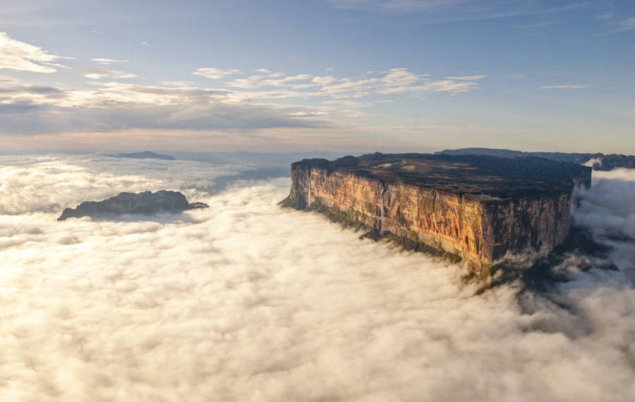
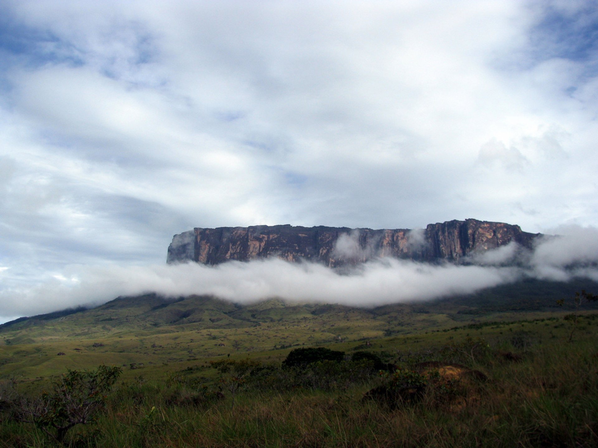
- Physical Characteristics: It stands at an elevation of approximately 2,810 meters (9,219 feet) and covers an area of around 31 square kilometers (12 square miles). The mountain features sheer vertical cliffs on all sides, giving it a striking and unique appearance.
- Tepui Formation: Mount Roraima is part of a geological formation known as a tepui, which refers to a table-top mountain with steep, almost vertical walls and a flat plateau-like summit. Tepuis are considered ancient geological formations, dating back millions of years.
- Biodiversity: The summit of Mount Roraima is an otherworldly landscape characterized by unique flora and fauna. It is home to numerous endemic species, including carnivorous plants, orchids, and several rare bird species. The tabletop summit creates a distinct ecosystem that has been isolated for centuries.
- Cultural Significance: Mount Roraima holds cultural significance for the indigenous Pemon people who reside in the region. They consider the mountain sacred and believe it is the stump of a mighty tree that once held all the fruits and vegetables in the world.
- Popular Destination: Mount Roraima has become a popular tourist destination for adventurers and nature enthusiasts. The ascent to the summit requires a multi-day trek through challenging terrain, but the awe-inspiring views and unique geological features make it a worthwhile experience.
- Exploration and Inspiration: Mount Roraima has fascinated explorers and scientists for centuries. It served as inspiration for Sir Arthur Conan Doyle’s novel “The Lost World” and has been a subject of scientific research due to its isolated ecosystems and fascinating geological history.
It’s worth noting that access to Mount Roraima is primarily through the Venezuelan side of the mountain, but political and logistical considerations may affect current accessibility. As always, it’s important to gather up-to-date information and consult local authorities or travel agencies before planning a visit.

Location and Surrounding Region
Mount Roraima is located in the southeastern part of Venezuela, specifically within Canaima National Park. Canaima National Park is a UNESCO World Heritage site and covers an area of approximately 30,000 square kilometers (11,600 square miles).
The mountain itself is situated near the borders of Brazil and Guyana. It forms part of the Pakaraima Mountain range, which extends across all three countries. The region is characterized by vast savannahs, dense rainforests, and numerous rivers and waterfalls.
The nearest town to Mount Roraima is Santa Elena de Uairén, which serves as a gateway for visitors to the area. Santa Elena de Uairén is located in the southeastern part of Venezuela, close to the border with Brazil. It has basic tourist amenities such as accommodations, restaurants, and transportation options.
The surrounding region is known as the Gran Sabana, or the Great Savanna, and is renowned for its breathtaking landscapes. It is characterized by expansive grasslands, dramatic flat-topped mountains (tepuis), and picturesque waterfalls, including the famous Angel Falls, the highest waterfall in the world.
The Gran Sabana is also home to indigenous communities, primarily the Pemon people, who have inhabited the region for centuries. These communities have a rich cultural heritage and maintain a deep connection with the land and its natural wonders.
Exploring the region around Mount Roraima offers visitors the opportunity to witness stunning natural beauty, learn about indigenous cultures, and engage in various outdoor activities such as hiking, wildlife spotting, and visiting remote waterfalls and rivers.

Formation and Geologic History
Mount Roraima, along with other tepuis in the region, is a result of unique geological processes that occurred over millions of years. Here’s a summary of the formation and geologic history of Mount Roraima:
- Tepui Formation: Tepuis are ancient table-top mountains characterized by steep vertical walls and flat, plateau-like summits. They are part of the larger Guiana Shield, a geological formation that covers parts of Venezuela, Brazil, Guyana, and Suriname. The Guiana Shield is composed of Precambrian rocks, which are some of the oldest rocks on Earth.
- Erosion and Uplift: The formation of Mount Roraima began around two billion years ago. Erosion and weathering processes gradually wore away the surrounding rocks, leaving behind isolated sandstone plateaus. Over time, tectonic uplift events caused these plateaus to rise, resulting in the formation of the tepuis.
- Sandstone Composition: Mount Roraima is predominantly composed of sandstone, specifically quartzite. Sandstone is a sedimentary rock formed from the deposition and compression of sand particles. The unique layering of sandstone in the region contributes to the distinctive vertical cliffs and rugged formations seen on Mount Roraima.
- Erosional Sculpting: The flat tabletop summit and vertical cliffs of Mount Roraima were shaped by extensive erosion. The combination of weathering, rainfall, and the action of rivers and streams gradually carved the sandstone, creating the distinctive features we see today. The erosional processes continue to shape the mountain, albeit at a slow pace.
- Glacial Influence: During the Pleistocene epoch (commonly known as the Ice Age), the climate in the region was colder, and glaciers covered the mountain summits. Glacial activity further influenced the shaping of the tepuis, smoothing their surfaces and contributing to the erosion patterns.
The geological history of Mount Roraima and the surrounding tepuis is a fascinating subject of study. These ancient and isolated formations have provided scientists with valuable insights into the Earth’s geological processes, the evolution of ecosystems, and the adaptation of unique species to these isolated habitats.

Tectonic Setting and Plateau Formation
The tectonic setting and the formation of plateaus like Mount Roraima involve a combination of geological processes. Here’s an overview of the tectonic setting and plateau formation:
- Tectonic Plates: The Earth’s lithosphere, which includes the crust and the uppermost part of the mantle, is divided into several large and small tectonic plates. The region where Mount Roraima is located sits on the northern edge of the South American Plate, which borders the Caribbean Plate to the north.
- Plate Interactions: The interaction between tectonic plates plays a significant role in the formation of plateaus. In the case of Mount Roraima, the collision between the South American Plate and the Caribbean Plate has influenced the geological processes in the region.
- Subduction and Uplift: The Caribbean Plate is currently subducting (diving beneath) the South American Plate along the northern coast of Venezuela. This subduction process has resulted in the uplift of the land in the region, leading to the formation of the Pakaraima Mountain range, which includes Mount Roraima.
- Faulting and Folding: The subduction and collision of plates create intense pressure and compression in the crust, leading to faulting and folding of rocks. These geological processes contribute to the formation of mountains and plateaus. The uplift and subsequent erosion of the surrounding rocks have exposed the resistant sandstone layers that form the tabletop summit of Mount Roraima.
- Erosion and Weathering: Once the plateau is uplifted, the erosional forces of wind, water, and ice shape the landforms over millions of years. Erosion gradually wears away the surrounding rocks, leaving behind the characteristic steep cliffs and flat plateau of Mount Roraima.
- Differential Erosion: The resistance of the sandstone layers compared to the surrounding rocks determines the differential erosion, resulting in the creation of the tabletop summit and vertical cliffs. The resistant sandstone layers on Mount Roraima have endured erosion better than the softer underlying rocks, leading to the formation of the distinct mountain features.
Plateau formation is a complex process that involves the interplay of tectonic forces, uplift, and erosion. Mount Roraima, as a result of these processes, stands as a remarkable example of a tabletop mountain with its unique and captivating geological features.
Erosional Processes and Formation of Tepuis
The formation of tepuis, including Mount Roraima, is primarily attributed to erosional processes over an extended period. Here’s an explanation of the erosional processes and the formation of tepuis:
- Weathering: Weathering refers to the breakdown and alteration of rocks at or near the Earth’s surface. Tepuis, including Mount Roraima, are primarily composed of sandstone, a type of sedimentary rock. Weathering agents such as wind, temperature variations, and chemical reactions gradually weaken the sandstone.
- Erosion by Water: Water plays a crucial role in the formation of tepuis. Precipitation, in the form of rain or melting snow, acts as an erosional agent. As water flows over the sandstone surfaces of the tepui, it erodes the rock, carving out channels and creating gorges and canyons.
- River and Stream Erosion: Rivers and streams that originate on the tabletops of the tepuis play a significant role in shaping their vertical cliffs. As these water bodies flow down the steep slopes of the tepuis, they erode the rock, creating waterfalls and cascades. Over time, these erosional processes contribute to the formation of the sheer cliffs that surround the tepuis.
- Chemical Weathering: Chemical reactions can also contribute to the erosion of the sandstone. Rainwater, carrying dissolved acids from the atmosphere, can react with the minerals in the rock, causing them to dissolve or break down. This process, known as chemical weathering, can weaken the sandstone and make it more susceptible to further erosion.
- Freeze-Thaw Action: In regions where temperatures fluctuate around the freezing point, freeze-thaw action can occur. Water seeps into cracks and crevices in the sandstone during wet periods. When the temperature drops and the water freezes, it expands, exerting pressure on the surrounding rock. The repeated freezing and thawing cycles can gradually break apart the sandstone, contributing to the formation of cliffs and other unique rock formations.
- Time and Persistence: The erosional processes described above have been at work over millions of years, gradually shaping the sandstone cliffs and sculpting the distinctive landscape of the tepuis. The resistant sandstone layers that form the flat summits have endured erosion better than the surrounding rocks, leading to the formation of the characteristic tabletops.
It’s important to note that while erosional processes have shaped the tepuis, their initial formation is attributed to tectonic uplift, as explained earlier. The combination of uplift and subsequent erosion has resulted in the formation of the majestic tepuis, including Mount Roraima, showcasing their unique and awe-inspiring geological features.
Unique Geological Features and Landforms
Mount Roraima and other tepuis in the region exhibit several unique geological features and landforms that contribute to their distinct appearance. Here are some of the notable features:
- Tabletop Summit: The most prominent feature of Mount Roraima and other tepuis is their flat, plateau-like summit. The tabletops can extend for several square kilometers and sit at an elevation significantly higher than the surrounding landscape. The summit of Mount Roraima, for example, spans approximately 31 square kilometers (12 square miles) and stands at an elevation of around 2,810 meters (9,219 feet).
- Vertical Cliffs: The tabletops of tepuis are characterized by steep, near-vertical cliffs that surround their perimeters. These cliffs can reach hundreds of meters in height and create an impressive and imposing sight. The verticality of the cliffs adds to the dramatic appearance of the tepuis.
- Waterfalls and Cascades: Tepuis are often adorned with numerous waterfalls and cascades that cascade down the steep cliffs. These waterfalls are formed as rivers and streams originating from the tabletops flow over the edges, resulting in stunning displays of cascading water. Some notable waterfalls associated with Mount Roraima include the Crystal Valley Falls and the Triple Point Falls.
- Erosional Potholes: Erosional processes have sculpted distinctive features on the tabletop surfaces of the tepuis. One such feature is erosional potholes, also known as giant’s kettles. These are circular depressions carved by the swirling action of water containing sand and rocks. Erosional potholes can vary in size and depth and add further intrigue to the unique landscape.
- Tafoni Patterns: Tepuis exhibit intricate patterns of weathering and erosion on their vertical cliff faces. These patterns, known as tafoni, appear as honeycomb-like structures, pits, or small caves etched into the rock surface. Tafoni patterns give the cliffs a textured and aesthetically appealing appearance.
- Unique Flora and Fauna: The isolated ecosystems found on the summits and slopes of tepuis are home to a diverse range of unique flora and fauna. Many endemic plant species, including carnivorous plants and orchids, thrive in these isolated environments. Additionally, several rare and endemic bird species inhabit the tepuis, making them a haven for biodiversity.
The combination of the tabletop summit, vertical cliffs, waterfalls, erosional potholes, tafoni patterns, and unique biodiversity creates a mesmerizing and captivating landscape found on Mount Roraima and other tepuis. These geological features contribute to their status as iconic natural landmarks and attract adventurers and nature enthusiasts from around the world.

Exploration and Tourism
Exploration and tourism play significant roles in the popularity of Mount Roraima and the tepuis in the region. Here’s a look at their exploration history and the tourism opportunities they offer:
- Historical Exploration: Mount Roraima and the tepuis were first explored by European explorers in the 19th century. British explorer Sir Everard im Thurn, accompanied by guides from the Pemon indigenous community, made the first recorded ascent of Mount Roraima in 1884. Since then, the tepuis have fascinated adventurers, scientists, and nature lovers.
- Adventurous Trekking: Mount Roraima and other tepuis have become renowned destinations for trekking enthusiasts. The journey to the summit involves multi-day hikes through challenging terrains, including dense forests, river crossings, and steep slopes. Adventurers can experience the thrill of conquering the summit and witness the breathtaking panoramic views from the tabletop.
- Unique Natural Landscapes: The tepuis offer visitors the opportunity to witness unique and awe-inspiring natural landscapes. The combination of the tabletop summit, vertical cliffs, waterfalls, and diverse flora and fauna creates a truly remarkable environment. The chance to explore and immerse oneself in such pristine and isolated ecosystems is a major draw for nature enthusiasts.
- Indigenous Culture and Heritage: The region surrounding Mount Roraima is home to indigenous communities, primarily the Pemon people. Visitors have the opportunity to engage with the local culture, learn about traditional practices, and gain insights into their deep connection with the land. Cultural exchanges and interactions with indigenous communities can enrich the tourism experience.
- Photography and Nature Observation: Mount Roraima and the surrounding tepuis offer stunning vistas and unique photo opportunities. The surreal landscapes, dramatic cliffs, waterfalls, and endemic flora and fauna provide photographers with a wealth of subjects to capture. Birdwatching enthusiasts can also spot rare and endemic bird species in their natural habitats.
- Responsible and Sustainable Tourism: As tourism to Mount Roraima and the tepuis increases, it’s important to prioritize responsible and sustainable practices. This includes respecting the natural environment, following designated trails, minimizing waste, and supporting local communities in a culturally sensitive manner. Responsible tourism ensures the long-term preservation of the unique ecosystems and cultural heritage of the region.
It’s worth noting that access to Mount Roraima and the tepuis may have certain restrictions or require permits, and it is essential to gather up-to-date information and follow local regulations. Additionally, engaging local guides or tour operators familiar with the area can enhance safety and provide valuable insights into the natural and cultural aspects of the region.
Summary of key points
- Location: Mount Roraima is located in southeastern Venezuela, within Canaima National Park, near the borders of Brazil and Guyana.
- Geological Formation: Mount Roraima is a tepui, an ancient table-top mountain formed through a combination of tectonic uplift and erosional processes over millions of years. It is predominantly composed of sandstone.
- Unique Geological Features: Mount Roraima and the tepuis exhibit distinct characteristics, including a flat tabletop summit, vertical cliffs, waterfalls, erosional potholes, and tafoni patterns.
- Tectonic Setting: The region is part of the northern edge of the South American Plate, which is subducting the Caribbean Plate, leading to uplift and the formation of the Pakaraima Mountain range.
- Erosional Processes: Erosion by water, river and stream erosion, chemical weathering, freeze-thaw action, and the passage of time have shaped the cliffs, waterfalls, and tabletops of Mount Roraima.
- Exploration and Tourism: Mount Roraima has a history of exploration dating back to the 19th century. It offers adventurous trekking opportunities, unique natural landscapes for photography and nature observation, insights into indigenous culture, and the chance to engage in responsible and sustainable tourism practices.
Exploring Mount Roraima and the surrounding region provides visitors with an incredible experience of witnessing extraordinary geological formations, immersing themselves in pristine ecosystems, and engaging with local communities and their rich cultural heritage.


