")


10 Places That Look Like Other Planets

Earth is generally referred to as the Blue Planet, but within its familiar landscapes there are places so alien that they can easily be confused with distant worlds. These locations share geological, chemical or atmospheric characteristics with other planets and moons in the solar system, making them invaluable for scientific research and breathtaking in their appearance.
Most of these places remain relatively unknown to the general public, overshadowed by more famous destinations. However, they offer something unique: a glimpse of what planetary surfaces beyond Earth might look like. Some resemble Mars with their iron-rich red soils, others reflect the sulfuric landscapes of Venus or Io, and some evoke the frozen methane lakes of Titan.
These terrestrial analogs serve critical scientific purposes. NASA, ESA and other space agencies regularly use them as testing grounds for rovers, instruments and exploration techniques. Astrobiologists study extremophile organisms in these environments to understand how life might exist elsewhere. Geologists examine their formation processes to interpret observations from planetary missions.
The following ten locations represent some of Earth’s most alien landscapes, specifically chosen for being lesser-known yet geologically fascinating. These are not typical tourist destinations but remote, harsh and extraordinarily strange places where Earth reveals its most extraterrestrial character.
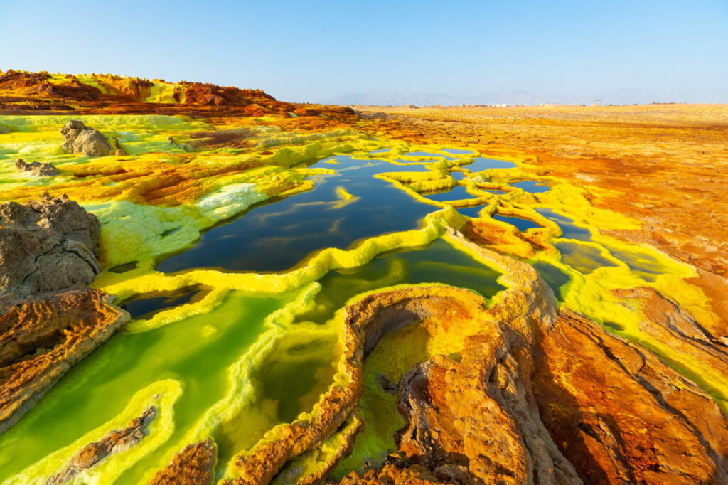
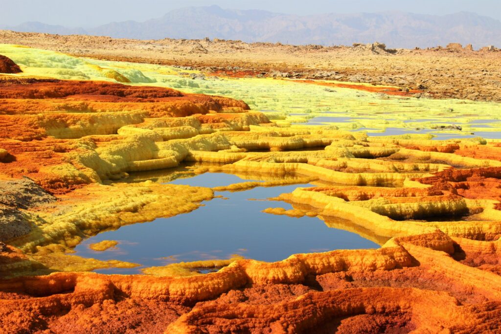
1. Dallol, Ethiopia
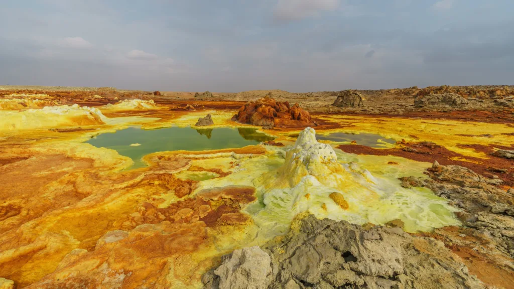
The Alien Landscape
Dallol sits in the Danakil Depression, one of the hottest and most inhospitable places on Earth. The landscape explodes with unnatural colors: acidic pools in brilliant yellow, green and orange; mineral deposits forming bizarre shapes like alien coral; and steam vents releasing sulfurous gases. Ground temperature can exceed 50°C and the air shimmers with heat. Salt formations create white crusts that crack and buckle, while iron and sulfur compounds paint the terrain in colors that seem impossible in nature.
The Geology
Dallol is a volcanic crater formed by phreatomagmatic eruptions—explosions caused when magma encounters groundwater. The area sits below sea level in an active tectonic zone where the African continent is slowly splitting apart. Magma chambers beneath the surface heat groundwater, which dissolves minerals from surrounding rocks and brings them to the surface through hydrothermal vents.
The extreme acidity (pH levels below 1 in some pools) results from sulfuric acid formed when volcanic sulfur compounds dissolve in water. The vibrant colors come from dissolved minerals: sulfur creates yellows, iron oxide produces reds and oranges, and various salts contribute whites and greens. The formations grow continuously as mineral-rich water evaporates, leaving behind deposits that build up into towers, terraces and pool rims.
Planetary Analog
Dallol resembles what we might expect on Io, Jupiter’s volcanically active moon, which has extensive sulfur deposits and active volcanism. It also provides insights into early Mars, which likely had similar hydrothermal systems when liquid water was abundant. The extreme conditions make Dallol valuable for astrobiology research—if life can survive here, it expands our understanding of life’s limits elsewhere.
2. Socotra Island, Yemen
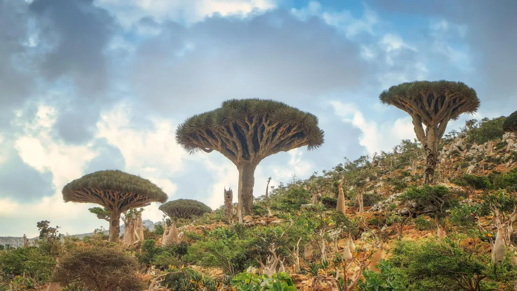
The Alien Landscape
Socotra appears pulled from science fiction. Dragon’s Blood trees, with their umbrella-shaped crowns and bulbous trunks, dominate the landscape like alien flora. Desert roses (Adenium obesum) with swollen trunks store water in shapes that seem designed rather than evolved. The Cucumber Tree (Dendrosicyos socotranus) is a tree that appears to be a giant succulent. Over one-third of Socotra’s plant species exist nowhere else on Earth.
The landscape itself is equally strange: limestone plateaus carved by erosion into bizarre formations, white sand dunes meeting turquoise waters, and caves with stalactites containing marine fossils now hundreds of meters above sea level. The combination of endemic biology and unusual geology creates an environment unlike anywhere else on the planet.
The Geology
Socotra separated from mainland Africa approximately 6 million years ago during the opening of the Gulf of Aden. This isolation allowed evolution to proceed independently, creating the unique flora. The island consists primarily of Precambrian basement rocks overlain by limestone deposited when the region was submerged beneath ancient seas.
Tectonic uplift raised these marine sediments hundreds of meters above sea level. Wind and rare but intense rainfall carved the limestone into sharp ridges and deep wadis. The caves formed through dissolution of limestone by acidic groundwater, preserving fossils from when the area was an ancient seabed.
Planetary Analog
Socotra’s isolated ecosystem and unusual life forms make it relevant for studying how life might evolve independently on other worlds. The extreme adaptation of plants to harsh, dry conditions with limited water mirrors challenges life would face on Mars or other arid planetary environments. The landscape’s strange beauty also evokes what colonized exoplanets might look like after terraforming begins but before Earth-like ecosystems fully develop.
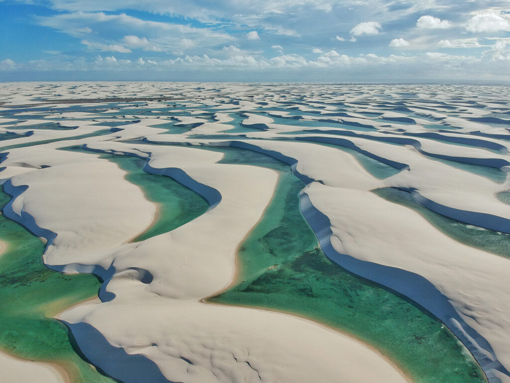
3. Salar de Uyuni (Rainy Season), Bolivia
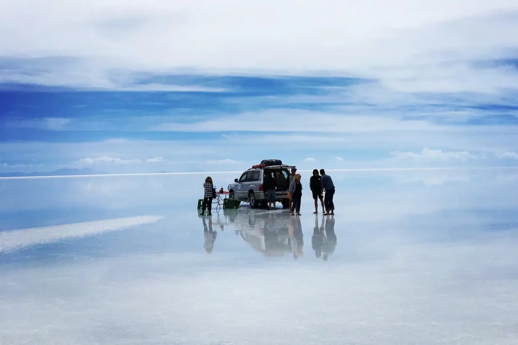
The Alien Landscape
Most people know Salar de Uyuni as the world’s largest salt flat, but during the brief rainy season it transforms into something more extraordinary: a mirror. A thin layer of water covers the salt, creating a perfectly reflective surface that extends to the horizon in all directions. Sky and ground become indistinguishable. Walking on this surface feels like floating in space; clouds reflect both below and above simultaneously.
At night the effect becomes even more surreal. Stars reflect perfectly on the water’s surface, creating the illusion of walking through space itself. The Milky Way appears both above and below, and the horizon vanishes completely. Few natural phenomena so completely disorient human perception of space and orientation.
The Geology
Salar de Uyuni formed through the repeated filling and evaporation of ancient lakes. The area was covered by a series of prehistoric lakes beginning approximately 40,000 years ago. As climate became drier, these lakes evaporated, leaving behind dissolved salts. The process repeated multiple times, accumulating a salt crust up to 10 meters thick covering over 10,000 square kilometers.
The flat surface results from the crystalline structure of salt, which forms horizontal layers as it precipitates from evaporating water. The salt crust sits atop brine and mud, which occasionally break through the surface, creating hexagonal patterns where the salt crust has fractured and reformed. The extreme flatness—variations are less than one meter across the entire expanse—makes it useful for calibrating satellite altimeters.
Planetary Analog
The mirror effect resembles what might be seen on worlds with shallow liquid surfaces under calm atmospheric conditions. More significantly, the salt deposits and formation process mirror what we expect to find in dried lake beds on Mars. NASA has studied Salar de Uyuni as an analog for understanding Mars’ ancient lakes and how to detect life-indicating minerals in evaporite deposits.
4. Lut Desert (Dasht-e Lut), Iran
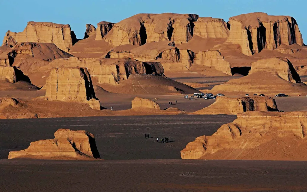
The Alien Landscape
The Lut Desert contains some of Earth’s hottest surface temperatures—NASA satellite measurements recorded 70.7°C in 2005. The landscape features vast expanses of black volcanic rock that absorb solar radiation, creating temperatures lethal to most life. But the most alien features are the kaluts—massive wind-carved rock formations that rise like ancient ruins or alien megastructures.
These kaluts stretch in parallel lines for dozens of kilometers, separated by corridors of sand. Some resemble castles, others look like carved pillars or abstract sculptures. The formations are so regular they appear artificial, yet they’re entirely natural products of wind erosion. The scale is overwhelming—some kaluts rise over 75 meters high, creating canyons and passageways that twist through the desert.
The Geology
The Lut Desert sits in a topographic depression where surrounding mountains block precipitation. This creates a hyperarid environment receiving essentially no rainfall. The black rocks are volcanic deposits and dark sedimentary rocks that absorb and retain heat, creating the extreme surface temperatures.
The kaluts form through a specific erosion process. The sedimentary rocks have varying resistance to erosion—some layers are harder than others. Wind carrying sand acts as an abrasive, selectively wearing away softer layers while harder layers remain. Over millennia, this creates the parallel ridges and valleys. The north-south orientation aligns with prevailing wind direction, which has been consistent for thousands of years.
The sand between kaluts accumulates in specific patterns determined by wind dynamics. The corridors act like wind tunnels, accelerating airflow and transporting sand through the system. This creates self-organizing patterns that maintain themselves over geological timescales.
Planetary Analog
The Lut resembles what we might expect in the hottest regions of Mars or Mercury. The extreme temperatures and total absence of water make it relevant for studying survival limits of life. The wind-carved formations are similar to yardangs observed on Mars, helping scientists understand Martian wind patterns and erosion processes. The black rocks and heat retention also mirror conditions on certain volcanic regions of Venus.
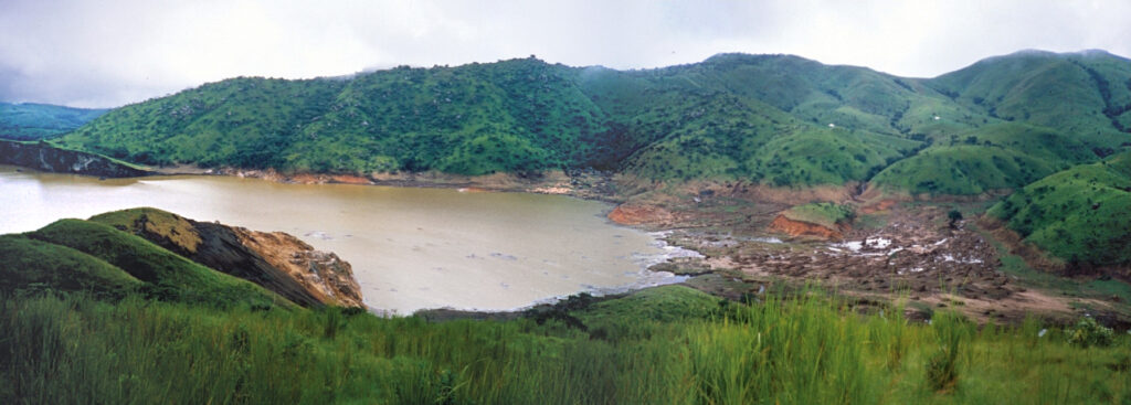
5. Lake Natron, Tanzania
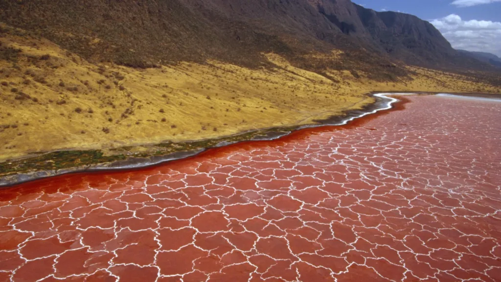
The Alien Landscape
Lake Natron appears blood-red from above, its waters so caustic they can calcify animals that die in them, turning corpses into eerie statues. The lake’s surface often appears crusty with salt deposits, creating patterns that look like alien skin. Steam rises from hot springs around the lake’s edges, and in dry seasons the salt flats display spiral patterns formed by halophilic bacteria that thrive in the extreme conditions.
The surrounding landscape is equally dramatic: the active volcano Ol Doinyo Lengai rises nearby, erupting unusual natrocarbonatite lava that flows black and quickly turns white upon cooling. This is the only volcano on Earth erupting this type of lava, making the region geologically unique.
The Geology
Lake Natron forms in a closed basin within the East African Rift System. Water entering the lake has no outlet except evaporation, concentrating dissolved minerals. The lake’s extreme alkalinity (pH up to 10.5) and high sodium carbonate content result from volcanic ash washing into the lake from Ol Doinyo Lengai and other nearby volcanoes.
The red color comes from halophilic microorganisms—salt-loving bacteria and algae that produce red pigments to protect themselves from intense sunlight. These organisms can survive in water so alkaline and salty it would be instantly lethal to most life. The calcification of dead animals occurs because the high carbonate content precipitates around organic material, essentially preserving it in stone.
Planetary Analog
Lake Natron’s extreme chemistry makes it an excellent analog for studying life in harsh conditions that might exist on other worlds. The soda lakes on Titan might have similar chemistry, and early Mars may have had similar alkaline lakes. The extremophile organisms thriving here expand our understanding of where life can exist. The unique lava from Ol Doinyo Lengai also provides insights into unusual magma chemistries that might exist on other planets.
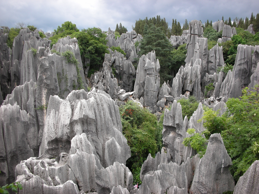
6. Qaidam Basin, China
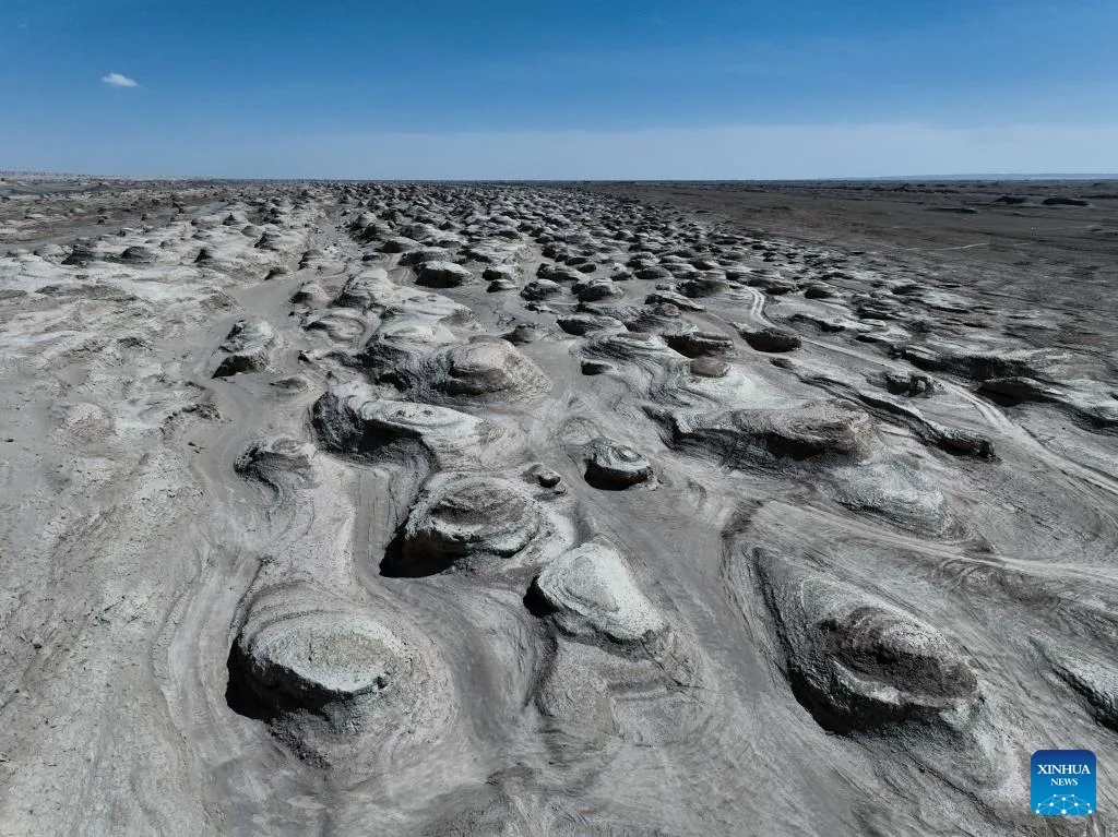
The Alien Landscape
The Qaidam Basin contains landscapes that appear constructed rather than natural. Yardang formations—wind-carved ridges—extend in parallel lines across the basin, creating patterns so regular they look like ancient roads or runways. The basin floor alternates between salt flats, dry lake beds and sand dunes, all under a sky that appears unnaturally pale due to dust in the atmosphere.
One area, called the “Water Yardang,” contains wind-carved formations surrounded by shallow, mineral-rich water that reflects their shapes. The water is too salty to freeze even in winter, and the mineral content creates unusual colors—greens, blues and milky whites that shift with light conditions.
The Geology
The Qaidam Basin sits on the Tibetan Plateau at elevations around 3,000 meters. It’s a closed basin surrounded by mountains, making it extremely arid. Ancient lakes once filled the basin, but as climate changed, they evaporated, leaving behind thick salt and sediment deposits.
The yardang formations are carved from these sediment layers by persistent winds. The basin’s high elevation and isolation create strong, consistent wind patterns that have sculpted the landscape over thousands of years. Different sediment layers have varying resistance to erosion, creating the banded appearance visible in many formations.
The salt deposits are being commercially extracted, but the remoteness and harsh conditions keep much of the basin undeveloped. Summer temperatures exceed 40°C, while winter temperatures drop below -20°C. The thin atmosphere at high elevation increases ultraviolet radiation and creates temperature extremes.
Planetary Analog
The Qaidam Basin is considered one of Earth’s best Mars analogs. NASA and the China National Space Administration use it for rover testing and instrument calibration. The yardang formations closely resemble Martian landforms, helping scientists understand Martian wind patterns. The salt deposits and dry lake beds mirror what orbital observations have found on Mars, making it valuable for planning sample return missions and understanding Martian geology.
7. Spotted Lake (Kliluk), British Columbia, Canada
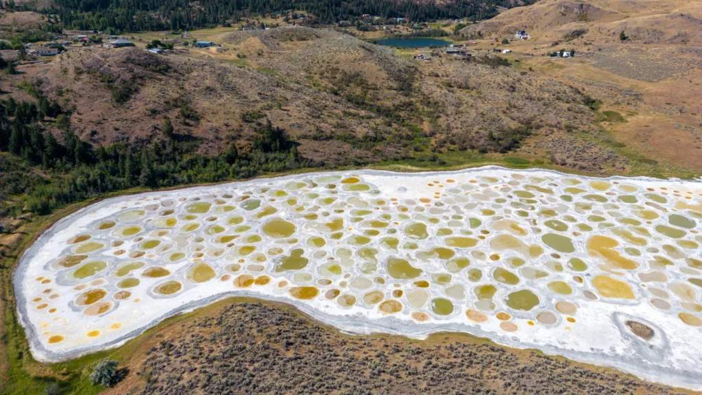
The Alien Landscape
During summer, Spotted Lake transforms into a polka-dotted landscape. As water evaporates, hundreds of distinct pools form, separated by white mineral deposits. Each pool contains different mineral concentrations, creating colors ranging from blue to green to yellow. The pattern changes throughout summer as evaporation continues and mineral concentrations shift.
From above, the lake appears artificial—too geometric, too colorful, too regular to be natural. The spots are so distinct they cast shadows, creating a three-dimensional landscape of mineral pools.
The Geology
Spotted Lake contains some of the highest mineral concentrations of any lake on Earth—primarily magnesium sulfate, calcium and sodium sulfates. The minerals come from surrounding rock layers that dissolve slowly and concentrate in the closed-basin lake.
As summer heat evaporates water, mineral concentration increases until salts begin to crystallize. Different minerals crystallize at different temperatures and concentrations, separating into distinct pools. The white areas are crystallized salts forming walkways between pools. The colors result from specific minerals and bacterial communities adapted to each pool’s unique chemistry.
Planetary Analog
Spotted Lake provides insights into how mineral-rich lakes might look on other worlds. The distinct pools separated by crystallized minerals could exist on Mars in areas where ancient lakes evaporated. The high mineral concentration and specific chemistry also make it relevant for studying life in extreme chemical environments—similar conditions might exist in subsurface oceans on Europa or Enceladus.
8. Rio Tinto, Spain
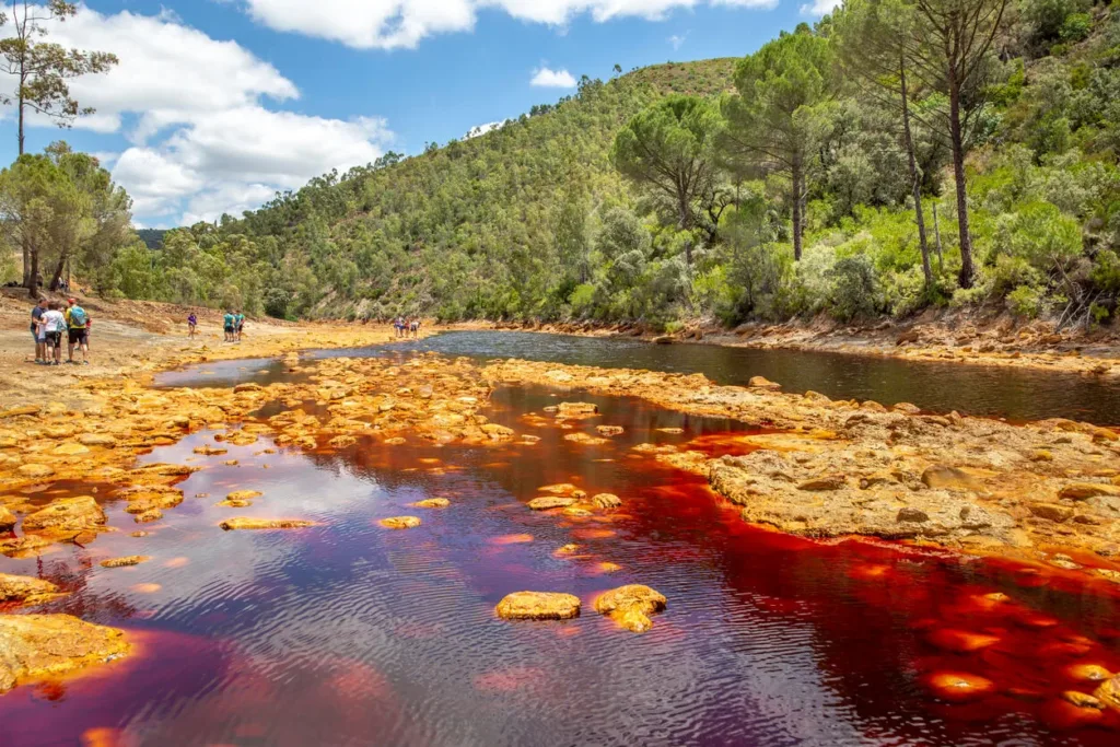
The Alien Landscape
Rio Tinto flows blood-red through southern Spain, its waters the color of rust. The river is intensely acidic (pH 2-3) and rich in heavy metals, yet it supports a unique ecosystem of extremophile organisms. The riverbanks display colors ranging from ochre to yellow to deep red, created by iron and sulfur compounds deposited by the acidic water.
The landscape surrounding the river resembles an alien wasteland: bare ground stained red, mineral deposits forming bizarre shapes, and pools of colored water separated by mineral crusts. Despite the extreme conditions, the area has been mined for over 5,000 years.
The Geology
Rio Tinto’s unusual chemistry results from pyrite oxidation in massive sulfide deposits. As pyrite (iron sulfide) weathers, it produces sulfuric acid and releases iron. The river water is essentially a dilute sulfuric acid solution saturated with dissolved metals.
The red color comes from ferric iron (Fe3+) in solution and precipitated as iron oxide minerals. The ecosystem is based on chemosynthesis—microorganisms that derive energy from oxidizing iron and sulfur compounds rather than photosynthesis. These organisms have adapted to the extreme acidity and metal concentrations.
Planetary Analog
Rio Tinto is extensively studied as a Mars analog. Its acidic, iron-rich water matches what we expect ancient Martian water might have been. The chemosynthetic ecosystem demonstrates that life doesn’t require neutral pH or low metal concentrations. If life exists on Mars, it might be similar to the extremophiles in Rio Tinto. NASA and ESA use Rio Tinto to test instruments designed to detect life on Mars.
9. Namib Desert Fairy Circles
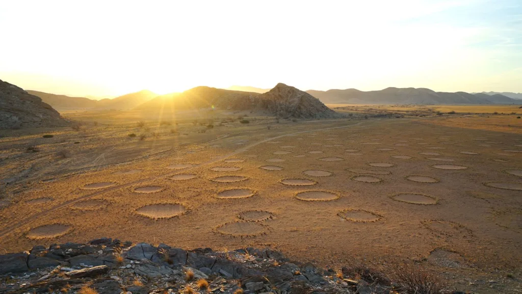
The Alien Landscape
Across portions of the Namib Desert, mysterious bare circles dot the landscape in remarkably regular patterns. These “fairy circles” range from 2 to 15 meters in diameter, each surrounded by a ring of taller grass. The circles persist for decades, then mysteriously disappear and form elsewhere.
From the air, the pattern appears almost artificial—too regular to be natural. The circles are evenly spaced, as if following some geometric rule. The surrounding grassland makes the bare circles even more conspicuous. No plants grow inside the circles, and the soil appears different from surrounding areas.
The Geology
The origin of fairy circles has been debated for decades. Recent research suggests they result from plant self-organization in response to water scarcity. Grasses compete for limited water, and the competition creates bare patches where no plants can survive. The patches maximize water availability for the surrounding grass ring.
The circles form preferentially in sandy soils with low water retention. The bare patches allow rainwater to percolate deeply rather than being immediately absorbed by plant roots. This deep water becomes available to the grass ring around each circle. The regular spacing results from competition—each circle maintains a zone where water is diverted to its surrounding vegetation.
The phenomenon appears unique to the Namib Desert and similar areas in Australia, suggesting specific soil and climate conditions are required.
Planetary Analog
While the circles are biological in origin, the self-organizing patterns resemble formations observed on Mars and other planets. Understanding how regular geometric patterns can emerge from simple local interactions helps interpret similar patterns seen in planetary imagery. The water dynamics are also relevant for understanding how limited water might be utilized by potential Martian life.
10. Blood Falls, Antarctica
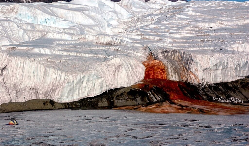
The Alien Landscape
From a white glacier in Antarctica’s McMurdo Dry Valleys, a cascade of blood-red water flows. The stark contrast—crimson against pristine white ice—creates an image that seems impossible. The red water stains the ice below as it slowly flows toward Lake Bonney.
The source of the water was mysterious for decades. The glacier appears solid, yet the red flow continues intermittently. The surrounding area is one of Earth’s driest deserts, receiving almost no precipitation, making any liquid water surprising.
The Geology
Blood Falls emerges from a subglacial lake trapped beneath Taylor Glacier. The lake has been isolated from the atmosphere for approximately 1.5 million years. The water is extremely salty—about three times saltier than seawater—which lowers its freezing point, allowing it to remain liquid despite temperatures below 0°C.
The red color comes from iron oxides. The lake water contains dissolved iron from the bedrock. When the iron-rich water reaches the surface and contacts oxygen, the iron oxidizes rapidly, creating rust-red iron oxide that colors the water and stains the ice.
The subglacial ecosystem is unique: microbial communities survive without sunlight, using sulfur and iron compounds for energy. The sealed environment has preserved these organisms for over a million years, creating an evolutionary experiment in isolation.
Planetary Analog
Blood Falls is crucial for astrobiology. The sealed, lightless, salty subglacial lake resembles conditions we expect might exist beneath the ice shells of Europa or Enceladus. If life can survive in Taylor Glacier’s subglacial lake, similar life might exist in extraterrestrial subsurface oceans. The iron chemistry also mirrors conditions that might have existed on early Mars.
Conclusion: Earth as Laboratory
These ten locations demonstrate that Earth contains landscapes as alien as any we might find elsewhere in the solar system. They serve as natural laboratories where scientists can study extreme conditions, test instruments and techniques, and explore the limits of life.
Many remain relatively unknown precisely because they’re difficult to access, uncomfortable to visit, or dangerous to explore. Yet their scientific value is immense. Every Mars rover has been tested in terrestrial analogs. Every astrobiology hypothesis about extreme life has been investigated in Earth’s extreme environments. Every instrument designed to detect life elsewhere has been calibrated using extremophiles from places like these.
These locations also remind us that Earth itself remains incompletely explored and understood. New discoveries continue to surprise scientists, revealing geological processes, chemical reactions, or biological adaptations previously unknown. If Earth still holds such surprises after centuries of scientific study, imagine what awaits discovery on truly alien worlds.