The rock cycle is a natural process that describes how rocks are formed, broken down, and transformed into different types of rocks over time. It involves various geological processes such as weathering, erosion, deposition, compaction, cementation, melting, crystallization, and uplift. The rock cycle is a continuous process that occurs over millions of years and is driven by the Earth’s internal heat, tectonic activity, and external factors such as weather and climate.
When rocks are pushed deep under the surface, they can melt
into magma. If the conditions for the magma to remain liquid are no longer
present, they are cooled and incorporated into an igneous rock. A rock that cools
in the earth is called intrusive or plutonic, and it cools very slowly to
produce a coarse-grained texture, such as rock granite. As a result of volcanic
activity, the magma (called lava when it reaches the Earth’s surface), which is
called extruded or volcanic rocks, can cool down very quickly while on the
surface where the Earth is exposed to the atmosphere. These rocks are fine
grained and sometimes so fast that no crystals form and do not result in a
natural glass like obsidian, but the most common fine grained rock is known as
basalt. Any of the three main rock types (igneous, sedimentary and metamorphic
rocks) can melt into magma and cool down to igneous rocks.
Crystallization: The
magma cools underground or on the surface and cures to a rickety rock. As the
magma cools, different crystals form at different temperatures that undergo
crystallization. For example, mineral olivine crystallizes at temperatures much
higher than quartz than magma. The cooling rate determines how much time the
crystals must form. Slow cooling produces larger crystals.
the rock cycle diagram
Metamorphic Rock Cycle Process
Metamorphic rocks can be changed physically or chemically to
form a different rock under the high pressures and temperatures. Regional
metamorphism refers to effects on large rock masses over a large area, usually
associated with mountain formation events in orogenic belts. These rocks
exhibit different bands of different mineralogy and colors, often called
foliation. Another main type of metamorphism occurs when a rock mass comes into
contact with an igneous intrusion that heats up this surrounding country rock.
This contact metamorphism results in an over temperature of the magma and / or
a rock which is altered and recrystallized by the addition of liquids that add
chemical material (metasomatism) to the surrounding rock. Any pre-existing rock
species can be replaced by metamorphism processes.
Metamorphism: When a rock is exposed to extreme heat and pressure within the Earth but does not melt, the rock becomes metamorphosed. Metamorphism can change the mineral composition and the texture of the rock. Thus, a metamorphic rock can be a new mineral composition and / or texture.
the rock cycle diagram
Sedimentary Rock Cycle Process
Rocks exposed to the atmosphere are variably unstable and
subject to weathering and erosion. Abrasion and erosion break down the original
rock into smaller pieces and remove dissolved materials. This shredded material
accumulates and is embedded by additional material. While an individual
sandstone is still a member of the rock class from which it is formed, it is a
rock sediment composed of mixed grains. Sedimentary rocks may consist of
collection of these small fragments (plastic clastic rock), accumulation and
lithification of living organisms, or removal of mineral sediment from
biologically deposited material. evaporation (sedimentary sedimentary rock).
Due to processes such as plant residues, such as elastic or organic material,
frangible fractions may form from fragments separated from larger rocks of any
species. Biogenic and sedimentary rocks consist of accumulation of minerals
from dissolved chemicals from all other rock types.
Erosion and
Sedimentation: Attrition, rock glides into smaller pieces on the surface of
the Earth. Small pieces are called sediments. Flowing water, ice and gravity
transport these deposits from one place to another by erosion. During
sedimentation, sediments are laid or deposited. In order to form a sedimentary
rock, the accumulated sediment must be compacted and cemented together.
The Rock Cycle Chart
Several processes can turn one type of rock into another
type of rock. The key processes of the rock cycle are crystallization, erosion
and sedimentation, and metamorphism.
Where does the energy that drives Earth’s rock cycle come
from? Processes driven by heat from Earth’s interior are responsible for
creating igneous and metamorphic rocks. Weathering and erosion, external
processes powered by energy from the Sun, produce the sediment from which
sedimentary rocks form.
Graphite is like diamond, It is a form of native carbon crystalline with its atoms arranged in a hexagonal structure that is opaque and dark gray to black. It occurs as hexagonal crystals, flexible sheets, scales, or large masses. It may be earthy, granular, or compact. Graphite forms from the metamorphism of carbonaceous sediments and the reaction of carbon compounds with hydrothermal solutions. It occurs naturally in this form and is the most stable form of carbon under standard conditions. Under high pressures and temperatures it converts to diamond. It looks dramatically different from diamond and is at the other end of the hardness scale. It’s softness is due to the way carbon atoms are bonded to each other rings of six carbon atoms are arranged in widely spaced horizontal sheets. The atoms are strongly bonded within the rings but very weakly bonded between the sheets. It is used in pencils and lubricants. Its high conductivity makes it useful in electronic products such as electrodes, batteries, and solar panels.
Name: From the Greek to write, in allusion to its use as a crayon.
Association: A wide variety of minerals stable in the metamorphic conditions under which graphite forms. In meteorites, in nodules with troilite, silicates
Polymorphism & Series: Polymorphous with chaoite, diamond, and lonsdaleite.
It is formed by metamorphism of sedimentary carbonaceous material by reduction of carbon compounds; primary component in igneous rocks. It occurs in metamorphic rocks as a result of the reduction of sedimentary carbon compounds during metamorphic rocks. It is also seen in magmatic rocks and meteorites. It-related minerals are quartz, calcite, mica and tourmaline. China, Mexico, Canada, Brazil and Madagascar are the main export sources of mined.
Synthetic Graphite
Synthetic graphite is a material consisting of graphitic
carbon which has been obtained by graphitizing of non-graphitic carbon, by CVD
from hydrocarbons at temperatures above 2500 K, by decomposition of thermally
unstable carbides or by crystallizing from metal melts supersaturated with
carbon.
The term artificial it is often used synonymously with synthetic graphite. However, the term synthetic graphite is preferred since their crystals are thought to be composed of carbon macromolecules. The term synthetic graphite is used predominantly for graphitized carbon, although the term CVD includes pyrolytic graphite as well as carbide decomposition residues. Such common uses are the same as the definition above. Synonyms for this most important type of synthetic graphite are Acheson graphite and electrograph.
Uses Area
Natural graphite is mostly used for refractories, batteries, steelmaking, expanded graphite, brake linings, foundry facings and lubricants.
Crucibles began using very large flake graphite, and carbon-magnesite brick requiring not quite so large flake graphite; for these and others there is now much more flexibility in the size of flake required, and amorphous graphite is no longer restricted to low-end refractories.
The use of graphite in batteries has increased in the last 30 years. Natural and synthetic are used to construct electrodes in major battery technologies.
The demand for batteries, As an example, a lithium-ion battery in a fully electric Nissan Leaf contains nearly 40 kg of graphite.
Natural graphite in steelmaking mostly goes into raising the carbon content in molten steel, and can also be used to lubricate the dies used to extrude hot steel.
Natural amorphous and fine flake graphite are used in brake linings or brake shoes for heavier (nonautomotive) vehicles, and became important with the need to substitute for asbestos.
A foundry facing mold wash is a water-based paint of amorphous or fine flake. Painting the inside of a mold with it and letting it dry leaves a fine graphite coat that will ease separation of the object cast after the hot metal has cooled.
Use of synthetic
graphite
High-focal pyrolytic graphite (HOPG) is the highest quality synthetic form of graphite. In scientific research, it is used as the length standard for scanner calibration, especially on a scanning probe microscope.
It electrodes carry electricity that melts scrap iron and steel in electric arc furnaces, the majority of steel furnaces, and sometimes melts directly reduced iron (DRI). They are made from petroleum coke after being mixed with coal tar tar.
Electrolytic aluminum smelting also uses graphite carbon electrodes. On a much smaller scale, synthetic discharge electrodes are used to make injection molds for plastics in the electrical discharge process (EDM).
Special grades of synthetic graphite, such as gilsocarbon, find utility as a matrix and neutron moderator in nuclear reactors. The low neutron cross section also recommends the use in recommended fusion reactors.
It (carbon) fiber and carbon nanotubes are also used in carbon fiber reinforced plastics and heat-resistant composites such as reinforced carbon-carbon (RCC). Commercial structures made of carbon fiber graphite composites include fishing rods, golf club shafts, bicycle frames, sports car body panels, the body of the Boeing 787 Dreamliner and the body of the pool marker bars.
Modern smokeless powder is coated with graphite to prevent the accumulation of static charge.
It was used in at least three radar absorbing materials. Sumpf and Schornsteinfeger used in U-boat snorkels to reduce radar cross-sections were mixed with rubber. F-117 Nighthawk was also used on the tiles on the secret strike fighters.
Graphite composites are used as absorbers for high energy particles (eg, in the LHC beam dump).
Graphite recycling
The most common way of graphite recycling occurs when synthetic graphite electrodes are produced and cut into pieces or discard lathes, or when the electrode (or other) is used up to the electrode holder. A new electrode replaces the old one, but most of the old one remains. This is crushed and sized and the resulting graphite powder is mostly used to increase the carbon content of the molten steel. It-containing refractories are sometimes recycled, but often not because of graphite: the largest bulk materials such as carbon-magnesite bricks containing only 15-25% graphite often contain very little graphite. However, some recycled carbon-magnesite bricks are used as the basis for furnace repair materials, while broken carbon-magnesite bricks are used in slag air conditioners. The crucibles have a high graphite content, while the crucibles used and then recycled have a small volume.
A high quality flake graphite product very similar to
natural leaf graphite can be made from steelmaking. Kish is a large volume of
molten waste filtered from the molten iron feed into a basic oxygen furnace and
consists of a mixture of graphite (precipitated from supersaturated iron),
lime-rich slag and some iron. The iron is recycled in place and a mixture of
graphite and slag is left. The best recovery process uses hydraulic grading
(using water flow to separate minerals by specific gravity: graphite is light
and almost precipitates) to obtain a 70% graphite concentrate. Leaching of this
concentrate with hydrochloric acid yields a 95% graphite product with a flake
size down to 10 sieves.
Distribution
Numerous localities, but only a few afford well-crystallized
examples.
In the USA, at Monroe and Ticonderoga, Essex
Co., New York; at Franklin and Sterling Hill, Ogdensburg, Sussex Co., New
Jersey.
In Canada, commercially significant occurrences
in Quebec, at Buckingham and Grenville, and in adjacent parts of Ontario.
In Russia, from Nizhni Tunguski, east of
Turukhansk, near the Yenisei River, Siberia; at Shunga, Karelia.
Around Ratnapura, Matara, and Kurunegale, Sri
Lanka, large deposits of pure material.
At Passau, Bavaria, Germany.
From Pargas, Finland.
In England, at Barrowdale, near Keswick,
Cumbria.
In Mexico, at Santa Maria, Sonora, formed by
metamorphism of coal beds.
References
Bonewitz, R. (2012). Rocks and minerals. 2nd ed. London: DK Publishing.
Handbookofmineralogy.org. (2019). Handbook of Mineralogy. [online] Available at: http://www.handbookofmineralogy.org [Accessed 4 Mar. 2019].
Mindat.org. (2019). Graphite: Mineral information, data and localities.. [online] Available at: https://www.mindat.org/ [Accessed. 2019].
Smith.edu. (2019). Geosciences | Smith College. [online] Available at: https://www.smith.edu/academics/geosciences [Accessed 15 Mar. 2019].
Hornblende is a inosilicate amphiboleminerals, which are two type hornblende minerals. They are ferrohornblende and magnesiohornblende. They are an isomorphous mixture of three molecules; a calcium-iron-magnesium silicate, an aluminium-iron-magnesium silicate, and an iron-magnesium silicate.The name hornblende is applied to a group of minerals that can be distinguished from each other only by detailed chemical analysis. The two end-member hornblendes—iron-rich ferrohornblende and magnesiumrich magnesiohornblende—are both calcium-rich and monoclinic in crystal structure. Other elements, such as chromium, titanium, and nickel, can also appear in the crystal structures of the group. The concentrations of these elements are an indicator of the metamorphic grade of the mineral. Specimens are green, dark green, or brownish green to black in color. Crystals are usually bladed and unterminated, and they often show a pseudohexagonal cross section. Well-formed crystals are short to long prisms. They also occurs as cleavable masses and radiating groups. The mineral forms in metamorphic rocks, especially gneisses, hornblende schists, amphibolites, and magnesium- and iron-rich igneous rocks.
Name: The word it is derived from the German horn and blenden, to ‘deceive’ in allusion to its similarity in appearance to metal-bearing ore minerals.
White,
colorless – (brittle, often leaves cleavage debris behind instead of a
streak)
Luster
Vitreous
Cleavage
Two directions intersecting at 124 and 56 degrees
Diaphaneity
Translucent to nearly opaque
Mohs Hardness
5 to 6
Crystal System
Monoclinic
Ferro-hornblende Optical Properties
Color / Pleochroism
Pleochroic in various shades of green and
brown. In PPL a thin section of
Hornblende ranges from yellow -green to dark brown. Green varieties usually
have X= light yellow green, Y=green or grey-green and Z=dark green. Brownish
varieties have X=greenish-yelow/brown, Y=yellowish to reddish brown and
Z=grey to dark brown.
Cleavages at 56 and 124 degrees which form a
distinctive diamond shape in cross section.
Hornblende is easly confused with biotite. Distiguishing factors are the lack of birds
eye extinction and the two distinct cleavages. Simple twinning is relatively common.
Crystal habit and cleavage distinguish hornblende from dark-colored
pyroxenes.
Magnesio-hornblende Optical Properties
Color / Pleochroism
Pleochroic in various shades of green and
brown. In PPL a thin section of
Hornblende ranges from yellow -green to dark brown. Green varieties usually
have X= light yellow green, Y=green or grey-green and Z=dark green. Brownish
varieties have X=greenish-yelow/brown, Y=yellowish to reddish brown and
Z=grey to dark brown.
Cleavages at 56 and 124 degrees which form a
distinctive diamond shape in cross section.
Hornblende is easly confused with biotite. Distiguishing factors are the lack of birds
eye extinction and the two distinct cleavages. Simple twinning is relatively common.
Crystal habit and cleavage distinguish hornblende from dark-colored
pyroxenes.
It is the main mineral of amphibolites. Very dark brown to
black hornblendes containing titanium are normally called basaltic hornblendes,
as they are usually a component of basalt and related rocks. Hornblende easily
replaces chlorite and epidote.
A rare kind of hornblende contains less than 5% of iron
oxide, is gray to white in color and Edenite is named Edenite from Orange
County, New York.
Magnesio-hornblende Occurrence:
Common in amphibolites, schists, and pegmatitic alkalic gabbro. Also from welded
tu®s, granodiorites, granites, and tonalites.
Ferro-hornblende Occurrence:
From granites, granodiorites, and metabasalts; common in amphibolites and
schists. As reaction rims on ferroan hedenbergite.
Uses Area
It is the most abundant mineral in a rock known as amphibolite, which has numerous uses.
Crushed and used as road construction and railway ballast.
It was cut to be used as a dimension stone.
The highest quality pieces are cut, polished and sold under the name “black granite” for use as building facades, floor tiles, countertops and other architectural uses.
It was used to estimate the depth of crystallization of plutonic rocks. Those with low aluminum content are associated with crystallization at shallow depth, while those with high aluminum content are associated with greater crystallization depths. This information is also useful for understanding the crystallization of magma and for mineral research.
Distribution
Magnesio-hornblende
Very widespread. A few conrmed localities include:
Earthquakes are one of the most powerful and destructive natural phenomena that occur on our planet. They can cause widespread devastation, loss of life, and economic damage, making them a significant threat to human societies. Throughout history, the earth has experienced many powerful earthquakes that have left a lasting impact on the affected regions. These seismic events can vary in magnitude, with the most severe earthquakes reaching levels that are hard to comprehend. In this article, we will explore the ten most powerful earthquakes ever recorded in Earth’s history, examining their causes, impacts, and the lessons learned from these catastrophic events. Understanding the power and impact of these earthquakes can help us prepare for and mitigate the damage caused by future seismic events.
11 April ,2012 at 15.38 local time, Indian Ocean earthquakes were magnitude 8.6 undersea that near of Indonesian city of Aceh. Authorities were at tsunami call but subsequently cancelled .These were unusually strong intraplate earthquakes and the largest strike-slip earthquake ever recorded.
it occurred very remote from an inhabited place and produced no destructive tsunami (10 cm to 0.8 meter / 3.9 inches to 31.4 inches tsunamis were reported). 10 deaths and 12 injuries were reported – most of them caused by panic and/or heart attack.
9. Assam-Tibet Earthquake (1950) – 8.6
Assam-Tibet Earthquake(1950)
On August 15, 1950, Earthquake occured at Xizang-India border region and epicenter of earthquake located near Rima,Tibet, Result of earthquakes many buildings were destroyed and between 1.500 and 3.000 peaple were killed.
After the earthquake, large landslides blocked the Subansiri River. This natural dam broke 8 days later, creating a wave of 7 m (23 ft) high which inundated several villages and killed 536 people.
The earthquake also created around 5,000,000 homeless.
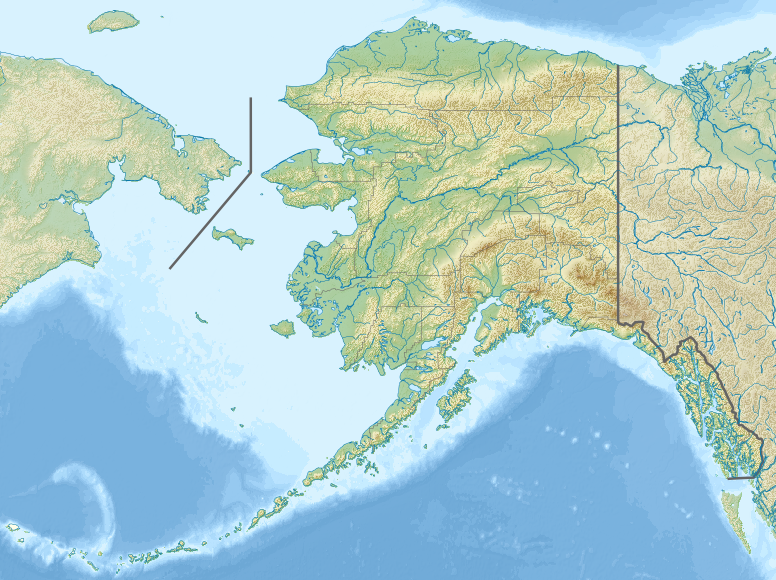
8. Rat Islands Earthquake(1965) – 8.7
1965 Rat Islands earthquake is located in Alaska
The Rat Islands earthquake of 1965 was a powerful earthquake that occurred on February 4, 1965, in the Rat Islands region of Alaska. The earthquake had a magnitude of 8.7, making it one of the most powerful earthquakes ever recorded.
The earthquake was caused by the subduction of the Pacific Plate beneath the North American Plate, which resulted in significant movement along the boundary between the two plates. The earthquake triggered a large tsunami that caused significant damage in several communities in Alaska, Hawaii, and California. However, due to the remote location of the epicenter and the low population density in the affected areas, the number of casualties was limited.
The Rat Islands earthquake was significant because it demonstrated the potential for large earthquakes to occur in remote areas, where they may not be detected immediately. It also highlighted the importance of early warning systems and the need for preparedness measures in coastal areas vulnerable to tsunamis.
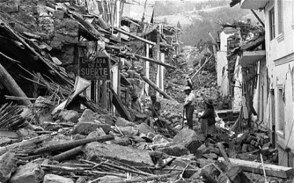
7. Ecuador-Colombia Earthquake(1906)– 8.8
The Ecuador-Colombia earthquake of 1906 was a powerful earthquake that occurred on January 31, 1906, along the border between Ecuador and Colombia. The earthquake had a magnitude of 8.8, making it one of the most powerful earthquakes ever recorded.
The earthquake caused significant damage and destruction in the affected areas, with many buildings being destroyed and landslides blocking roads and transportation routes. The death toll from the earthquake is estimated to be around 1,000 people, with many more injured or displaced.
The Ecuador-Colombia earthquake was caused by the movement of the South American Plate as it collided with the Nazca Plate, which resulted in significant movement along the boundary between the two plates. The earthquake triggered several aftershocks, and the effects were felt throughout the region.
6. Maule (Chile) Earthquake (2010)– 8.8
pics from http://www.scmp.com/news/world/article/1571468/massive-chilean-earthquake-2010-shook-antarctic-ice-sheet
2010 Maule Earthquake, also known as the 2010 Chile earthquake has occurred off the coast of central Chile on Saturday, 27 February at 03:34 local time (06:34 UTC) about 3 km (1.9 miles) off the coast of Pelluhue commune in the Maule Region, Chile. The intense shaking lasted for about three minutes. Several coastal towns in south-central Chile were devastated by the tsunami triggered by the earthquake. The tsunami also damaged the port at Talcahuano.
Buildings collapsed in many cities, including the capital, Santiago, causing many deaths. The authorities announced the final death toll of 525 victims and 25 people missing in January 2011.
5. Kamchatka, Russia Earthquake (1952) – 9.0
1952 Kamchatka Tsunami
On November 4, 1952, at 16:58 GMT (04:58 local time) a huge earthquake struck off the coast of Kamchatka Peninsula, in the far east of Russia. It produced a great destructive Pacific-wide tsunami with waves up to 15 meters (50 feet) which caused extensive damage to the Kamchatka Peninsula and the Kuril Islands, left an estimated 10,000 to 15,000 people dead. It was also very damaging in the Hawaiian Islands, but there were no human deaths attributed to the tsunami. The waves traveled as far as Peru, Chile and New Zealand. In Alaska, the Aleutian Islands and California, tsunami waves of up to 1.4 meters (4.6 feet) were observed.
4. Tōhoku Earthquake (2011) – 9.1
Japan’s devastating 8.9 magnitude earthquake in 2011 is continuing to cause problems, with seismologists calling the county’s most recent quake an ‘aftershock’. (Reuters)
On 11 March 2011 Friday, at 14:46 with the local time (05:46 UTC), a massive undersea megathrust earthquake off the coast of Japan occurred. The earthquake triggered a massive tsunami with waves up to 40.5 meters (133 feet) high. It was one of the deadliest in human history, the waves traveled inland as far as 6 miles (10 km) and caused extensive and severe structural damage in north-eastern Japan. Airports, roads and railroads destroyed, 127,290 buildings totally collapsed, 272,788 buildings half collapsed, and another 747,989 buildings partially damaged. A dam collapsed. The tsunami also caused nuclear accidents, primarily the level 7 meltdowns (means a Major accident, highest level, see notes 2) at three reactors in the Fukushima Daiichi Nuclear Power Plant complex.
On 10 March 2015, it was announced that the confirmed casualties were 15,894 deaths, 6,152 injured, and 2,562 people missing.
3. Sumatra Earthquake (2004)– 9.1
One of the deadliest natural disasters in recent history, the 2004 Sumatra Earthquake, also known as the 2004 Indian Ocean earthquake, occurred at 00:58:53 UTC on 26 December with the epicenter off the west coast of Sumatra, Indonesia. It ruptured the greatest fault length of any recorded earthquake, spanning a distance of 1500 km (900 miles). The resulting tsunami, with waves up to 30 meters (100 ft) high, caused up to a quarter of a million deaths.
2004 Indian Ocean earthquake and tsunami
The earthquake had also the longest duration of faulting ever observed, between 8.3 and 10 minutes. It caused the entire planet to vibrate as much as 1 centimeter (0.4 inches). Total energy released by the quake was 4.0×10²² joules (4.0×1029 ergs), or 9,600 gigatons of TNT, 550 million times that of Hiroshima atomic bomb. The vast majority of this energy was underground. The energy released on the Earth’s surface was estimated at 1.1×10¹⁷ joules or 26 megatons of TNT. This energy is equivalent to over 1,500 times that of the Hiroshima atomic bomb, but less than that of Tsar Bomba, the largest nuclear weapon ever detonated.
The resulting tsunami was given various names, including the 2004 Indian Ocean tsunami, South Asian tsunami, Indonesian tsunami, the Christmas tsunami (there were also hundreds of thousands of Christian tourists in the areas affected by the tsunami), and the Boxing Day tsunami.
2. Great Alaska Earthquake (1964)– 9.2
The 1964 Great Alaska earthquake (also known as Good Friday earthquake) occurred at 5:36 PM (local time, 3:36 UTC) on Good Friday, March 27 in the Prince William Sound region of Alaska. It lasted approximately 4.5 minutes and is the most powerful recorded earthquake in U.S. history.
Great Alaska Earthquake (1964)– 9.2
The earthquake triggered 27-foot (8.2 meters) tsunami which destroyed the village of Chenega, killing 23 of the 68 people who lived there. Survivors out-ran the wave, climbing to high ground. It also caused a massive underwater landslide. Port Valdez city harbor and docks were collapsed, 30 people perished.
A total of 139 people are believed to have died: 15 as a result of the earthquake itself, 106 from the subsequent tsunami in Alaska, 5 from the tsunami in Oregon, and 13 from the tsunami in California
1. Valdivia Earthquake (1960)– 9.5
Valdivia Earthquake from pics(http://santiagotimes.cl/en/wp-content/uploads/2018/05/sanfrancisco-earthquake-1906.png)
Also known as the Great Chilean earthquake (Spanish: Gran terremoto de Chile), it was the most powerful earthquake ever recorded. The earthquake hit on May 22 in the afternoon (19:11 GMT, 15:11 local time), approximately 100 miles (160 km) off the coast of Chile, parallel to the city of Valdivia. It lasted approximately 10 minutes and triggered a massive tsunami with waves up to 25 meters (82 feet). The main tsunami severely battered the Chilean coast, and raced across the Pacific Ocean and devastated Hilo, Hawaii. Waves as high as 10.7 meters (35 feet) were recorded even 10,000 kilometers (6,200 mi) from the epicenter, and as far away as Japan and the Philippines.
The death toll of 1960 Valdivia Earthquake is not certain – the total number of fatalities from the earthquake and tsunamis have been estimated between 1,000 and 6,000. About 3,000 people were injured.
Arsenic is a native element with the formula As and atomic number 33. Known since antiquity, arsenic is widely distributed in nature, although it is unusual in native form. It is classified as a semimetal, because it possesses some properties of metals and some of nonmetals. Crystals are rare, but when found they are rhombohedral. It usually occurs in massive, botryoidal to reniform, or stalactitic habits, often with concentric layers. On fresh surfaces, arsenic is tin-white, but it quickly tarnishes to dark gray. Native arsenic is found in hydrothermal veins, often associated with antimony, silver, cobalt, and nickel-bearing minerals. It is highly poisonous, although it is used in some medicines to treat infections. Arsenic-based compounds can be used in alloys to increase high-temperature strength and as a herbicide and pesticide.
The United States’ Environmental Protection Agency states
that all forms of arsenic are a serious risk to human health. The United
States’ Agency for Toxic Substances and Disease Registry ranked arsenic as
number 1 in its 2001 Priority List of Hazardous Substances at Superfund sites.
Arsenic is classified as a Group-A carcinogen. (Wikipedia, 2019)
Name: From the
Latin arsenicum, earlier Greek arrenikos, or arsenikos, masculine, an allusion
to its potent properties.
Distinct – yellowish brown and light grey to
yellowish grey
Color / Pleochroism
Weak
Twinning
Rare on {1014}, Pressure twinning on {0112}
Occurrence
In hydrothermal veins and deposits that contain other
arsenic minerals; may be in Co–Ag sulfide veins.
Arsenic comprises about 1.5 ppm (0.00015%) of the Earth’s crust, and is the 53rd most abundant element. Typical background concentrations do not exceed 3 ng/m3 in the atmosphere; 100 mg/kg in soil; and 10 μg/L in freshwater.
Arsenic Uses Area
The toxicity of arsenic to insects, bacteria, and fungi led to its use as a wood preservative
It was also used in various agricultural insecticides and poisons. For example, lead hydrogen arsenate was a common insecticide on fruit trees.
It is used as a feed additive in poultry and swine production, in particular in the U.S. to increase weight gain, improve feed efficiency, and to prevent disease
It is intentionally added to the feed of chickens raised for human consumption. Organic compounds are less toxic than pure arsenic, and promote the growth of chickens. Under some conditions, the arsenic in chicken feed is converted to the toxic inorganic form.
Medical use
During the 18th, 19th, and 20th centuries, a number of arsenic compounds were used as medicines, including arsphenamine (by Paul Ehrlich) and arsenic trioxide (by Thomas Fowler).
Arsenic trioxide has been used in a variety of ways over the past 500 years, most commonly in the treatment of cancer, but in medications as diverse as Fowler’s solution in psoriasis.
The main use is in alloying with lead. Lead components in car batteries are strengthened by the presence of a very small percentage of arsenic.
Gallium arsenide is an important semiconductor material, used in integrated circuits. Circuits made from GaAs are much faster (but also much more expensive) than those made from silicon.
Distribution
Numerous localities are known, most of only minor interest.
In Germany, from Freiberg, Schneeberg,
Johanngeorgenstadt, Marienberg, and Annaberg, Saxony; Wolfsberg and St.
Andreasberg, Harz Mountains; and Wieden, Black Forest.
In the Gabe-Gottes mine, Rauenthal, near
Sainte-Marie-aux-Mines, Haut-Rhin, France. At Jachymov (Joachimsthal), Prıbram,
and Cınovec (Zinnwald), Czech Republic.
In Romania, from Sacarımb (Nagyag), Hunyad, and
Cavnic (Kapnikbanya).
At Sterling Hill, Ogdensburg, Sussex Co., New
Jersey and Washington Camp, Santa Cruz Co., Arizona, USA.
In the Huallapon mine, Pasto Bueno, Ancash
Province, Peru. At Bidi, Sarawak Province, Borneo.
In the Akatani mine, Fukui Prefecture, Japan.
From the Dajishan tungsten deposits, Jianxi Province, China.
References
Bonewitz, R. (2012). Rocks and minerals. 2nd ed. London: DK Publishing.
Handbookofmineralogy.org. (2019). Handbook of Mineralogy. [online] Available at: http://www.handbookofmineralogy.org [Accessed 4 Mar. 2019].
Mindat.org. (2019). Orpiment: Mineral information, data and localities.. [online] Available at: https://www.mindat.org/ [Accessed. 2019].
Wikipedia contributors. (2019, June 8). Arsenic. In Wikipedia, The Free Encyclopedia. Retrieved 12:08, June 11, 2019, from https://en.wikipedia.org/w/index.php?title=Arsenic&oldid=900851916
Sulfur is the tenth most common element by mass in the universe, and the fifth most common on Earth. It (also spelled sulphur) is a chemical element with the symbol S and atomic number 16. It is abundant, multivalent, and nonmetallic. Under normal conditions, atoms form cyclic octatomic molecules with a chemical formula S8. Elemental sulfur is a bright yellow, crystalline solid at room temperature. It occurs in the form of sulfides, sulfates, and elemental sulfur. The bright yellow or orangish color of this mineral makes the mineral easy to identify. Sulfur forms pyramidal or tabular crystals, encrustations, powdery coatings, and granular or massive aggregates. Crystalline sulfur may exhibit as many as 56 different habits. Most sulfur forms in volcanic fumaroles, but it can also result from the breakdown of sulfide ore deposits. Massive form found in thick beds in sedimentary rocks, particularly those associated with salt domes. Sulfur is a poor conductor of heat, which means that specimens are warm to the touch.
Name: derived from the Latin word sulpur, which was Hellenized to sulphur. The spelling sulfur appears toward the end of the Classical period. (The true Greek word for sulfur, θεῖον, is the source of the international chemical prefix thio-.)
Morphology: Over
50 forms have been noted, blocky dipyramidal ones most common, also tabular and
sphenoidal; also found as powdery coatings, massive material, and in reniform
and stalactic forms.
Cell Parameters: a
= 10.468 Å, b = 12.870 Å, c = 24.49 Å
Yellow,
sulphur-yellow, brownish or greenish yellow, orange, white
Streak
Colourless
Luster
Resinous,
Greasy
Cleavage
Imperfect/Fair
Imperfect on {001}, {110} and {111}.
Diaphaneity
Transparent, Translucent
Mohs Hardness
1,5 – 2,5
Crystal System
Orthorhombic
Tenacity
Brittle
Density
2.07 g/cm3 (Measured) 2.076 g/cm3 (Calculated)
Fracture
Irregular/Uneven, Conchoidal
Parting
Parting on {111}
Sulfur Optical Properties
Type
Anisotropic
Color / Pleochroism
Visible
2V:
Measured: 68° , Calculated: 70°
RI
values:
nα = 1.958 nβ = 2.038 nγ = 2.245
Twinning
On {101}{011}{110} rare
Optic Sign
Biaxial (+)
Birefringence
δ = 0.287
Relief
Very High
Dispersion:
relatively weak r< v
Occurrence
Sulfur is widely distributed in nature. It is found in many minerals and ores, e.g., iron pyrites, galena, cinnabar, zinc blende, gypsum, barite, and epsom salts and in mineral springs and other waters. It is found uncombined in some volcanic regions and in large underground deposits in Sicily and in Texas and Louisiana. Its often occurs with coal, petroleum, and natural gas. It is found in meteorities, and deposits of it may be present near the lunar crater Aristarchus. The distinctive colors of Jupiter’s moon Io are believed to result from forms of molten, solid, and gaseous sulfur. It is a component of all living cells. The amino acids cysteine, methionine, homocysteine, and taurine contain sulfur as do some common enzymes; it is a component of most proteins. Some forms of bacteria use hydrogen sulfide (H 2S) in place of water in a rudimentary photosynthesislike process. It is absorbed by plants from soil as sulfate ions.
Uses Area
Elemental sulfur is used mainly as a precursor to other chemicals. Approximately 85% (1989) is converted to sulfuric acid (H2SO4):
Large quantities of sulfites are used to bleach paper and to preserve dried fruit. Many surfactants and detergents (e.g. sodium lauryl sulfate) are sulfate derivatives.
When silver-based photography was widespread, sodium and ammonium thiosulfate were widely used as “fixing agents”. Sulfur is a component of gunpowder (“black powder”).
It is increasingly used as a component of fertilizers. The most important form of sulfur for fertilizer is the mineral calcium sulfate.
It improves the efficiency of other essential plant nutrients, particularly nitrogen and phosphorus.
Organosulfur compounds are used in pharmaceuticals, dyestuffs, and agrochemicals. Many drugs contain sulfur; early examples being antibacterial sulfonamides, known as sulfa drugs. It is a part of many bacterial defense molecules.
Elemental sulfur is one of the oldest fungicides and pesticides. “Dusting sulfur”, elemental sulfur in powdered form, is a common fungicide for grapes, strawberry, many vegetables and several other crops.
Small amounts of sulfur dioxide gas addition (or equivalent potassium metabisulfite addition) to fermented wine to produce traces of sulfurous acid (produced when SO2 reacts with water) and its sulfite salts in the mixture, has been called “the most powerful tool in winemaking”.
It (specifically octasulfur, S8) is used in pharmaceutical skin preparations for the treatment of acne and other conditions. It acts as a keratolytic agent and also kills bacteria, fungi, scabies mites, and other parasites.
It can be used to create decorative inlays in wooden furniture. After a design has been cut into the wood, molten sulfur is poured in and then scraped away so it is flush.
References
Bonewitz, R. (2012). Rocks and minerals. 2nd ed.
London: DK Publishing.
Handbookofmineralogy.org.
(2019). Handbook of Mineralogy. [online] Available at:
http://www.handbookofmineralogy.org [Accessed 4 Mar. 2019].
Mindat.org.
(2019). Orpiment: Mineral information, data and localities.. [online] Available
at: https://www.mindat.org/ [Accessed. 2019].
Smith.edu.
(2019). Geosciences | Smith College. [online] Available at:
https://www.smith.edu/academics/geosciences [Accessed 15 Mar. 2019].
Silver is an element with the chemical symbol Ag and atomic number 47. Opaque and bright silvery white with a slightly pink tint, it readily tarnishes to either gray or black. Natural crystals of silver are uncommon, but when found they are cubic, octahedral, or dodecahedral. It is usually found in granular habit and as wiry, branching, lamellar, or scaly masses. Widely distributed in nature, it is a primary hydrothermal mineral. It also forms by alteration of other silver-bearing minerals. Much of the world’s silver production is a by-product of refining lead, copper, and zinc. It is the second most malleable and ductile metal, and it is important in the photographic and electronic industries. Most silver is produced as a byproduct of copper, gold, lead, and zinc refining. It has long been valued as a precious metal. Silver metal is used in many bullion coins, sometimes alongside gold: while it is more abundant than gold, it is much less abundant as a native metal.
Name: From an Old
English word for the metal soelfer, related to the German silber and the Dutch
zilver; the chemical symbol from the Latin argentum
Polymorphism &
Series: Forms a series with gold; the cubic form is 3C; hexagonal stacking polytypes
2H and 4H are known
Mineral Group:
Copper Group
Cell Data: Space
Group: Fm3m. a = 4.0862 Z = 4
Morphology: Crystals
are cubic, octahedral, dodecahedral to a cm. Often elongated to many cms in
herringbone twins and wires (crystals elongated along the [111] axis).
It is an extremely soft, ductile and malleable transition metal, though it is slightly less malleable than gold. Crystallizes in a face-centered cubic lattice with bulk coordination number 12, where only the single 5s electron is delocalized, similarly to copper and gold.
It has a brilliant white metallic luster that can take a high polish, and which is so characteristic that the name of the metal itself has become a color name.
Very high electrical and thermal conductivity is common to the elements in group 11, because their single s electron is free and does not interact with the filled d subshell, as such interactions (which occur in the preceding transition metals) lower electron mobility. The electrical conductivity of it is the greatest of all metals, greater even than copper, but it is not widely used for this property because of the higher cost. An exception is in radio-frequency engineering, particularly at VHF and higher frequencies where silver plating improves electrical conductivity because those currents tend to flow on the surface of conductors rather than through the interior.
Silver Optical Properties
Type
Isotropic
Color / Pleochroism
Non-pleochroic
Color
in reflected light
Brilliant silver white
Internal
Reflections
None
Twinning
Penetration twins on (111) with cubes from Kongsberg
and tetrahexahedrons from Michigan (bearpaws). Arborescent growths twinned on
(100) and on (111).
Silver Occurrence
A primary hydrothermal mineral, also formed by secondary
processes, especially in the oxidized portions of mineral deposits.
The abundance of silver in the Earth’s crust is 0.08 parts per million, almost exactly the same as that of mercury. It mostly occurs in sulfide ores, especially acanthite and argentite, Ag2S. Argentite deposits sometimes also contain native when they occur in reducing environments, and when in contact with salt water they are converted to chlorargyrite (including horn silver), AgCl, which is prevalent in Chile and New South Wales. Most other this minerals are pnictides or chalcogenides; they are generally lustrous semiconductors. Most true silver deposits, as opposed to argentiferous deposits of other metals, came from Tertiary period vulcanism.
It is usually found in nature combined with other metals, or in minerals that contain silver compounds, generally in the form of sulfides such as galena (lead sulfide) or cerussite (lead carbonate). So the primary production of requires the smelting and then cupellation of argentiferous lead ores, a historically important process. Lead melts at 327 °C, lead oxide at 888 °C and silver melts at 960 °C. To separate the silver, the alloy is melted again at the high temperature of 960 °C to 1000 °C in an oxidizing environment. The lead oxidises to lead monoxide, then known as litharge, which captures the oxygen from the other metals present. The liquid lead oxide is removed or absorbed by capillary action into the hearth linings.
Silver Uses Area
The earliest known coins were minted in the kingdom of Lydia in Asia Minor around 600 BC. The coins of Lydia were made of electrum, which is a naturally occurring alloy of gold and silver, which available within the territory of Lydia. Since that time, standards, in which the standard economic unit of account is a fixed weight of silver, have been widespread throughout the world until the 20th century.
Today, silver bullion has the ISO 4217 currency code XAG,
one of only four precious metals to have one (the others being palladium,
platinum, and gold).
Applications
The major use of silver besides coinage throughout most of
history was in the manufacture of jewellery and other general-use items, and
this continues to be a major use today.
Electrolytically refined pure silver plating is effective at
increasing resistance to tarnishing.
Wound dressings containing silver sulfadiazine or silver nanomaterials are used to treat external infections. It is also used in some medical applications, such as urinary catheters (where tentative evidence indicates it reduces catheter-related urinary tract infections) and in endotracheal breathing tubes (where evidence suggests it reduces ventilator-associated pneumonia).
It and its nanoparticles are used as an antimicrobial in a variety of industrial, healthcare, and domestic application: for example, infusing clothing with nanosilver particles thus allows them to stay odourless for longer
Silver and its alloys are used in cranial surgery to replace
bone, and silver–tin–mercury amalgams are used in dentistry.
Silver diammine fluoride, the fluoride salt of a
coordination complex with the formula [Ag(NH3)2]F, is a topical medicament
(drug) used to treat and prevent dental caries (cavities) and relieve dentinal
hypersensitivity.
It is very important in electronics for conductors and electrodes on account of its high electrical conductivity even when tarnished. Bulk silver and silver foils were used to make vacuum tubes, and continue to be used today in the manufacture of semiconductor devices, circuits, and their components.
Containing brazing alloys are used for brazing metallic materials, mostly cobalt, nickel, and copper-based alloys, tool steels, and precious metals.
Equipment made to work at high temperatures is often silver-plated. It and its alloys with gold are used as wire or ring seals for oxygen compressors and vacuum equipment.
The photosensitivity of the silver halides allowed for their
use in traditional photography, although digital photography, which does not
use silver, is now dominant.
Pure silver metal is used as a food colouring. It has the
E174 designation and is approved in the European Union.
Distribution
Numerous localities even for fine specimens.
Well-crystallized examples from:
in Germany, near Freiberg and Marienberg,
Saxony, and at St. Andreasberg, Harz Mountains.
Exceptionally developed at Kongsberg, Norway.
From Prıbram and Jachymov (Joachimsthal), Czech
Republic.
In the USA, on the Keweenaw Peninsula, Houghton
and Keweenaw Cos., Michigan; at Aspen, Pitkin Co., and from Creede, Mineral
Co., Colorado; and in Arizona, in the Silver King mine, Pinal Co. In Canada, in
large amounts from Cobalt; and in the Thunder Bay district, at Silver Islet, on
the north shore of Lake Superior, Ontario. Important production from Mexico, in
many states; finely crystallized from Batopilas, Chihuahua; masses over 1500 kg
from Arizonac, Sonora.
At Chanarcillo, south of Copiapo, Atacama,
Chile.
In Australia, at Broken Hill, New South Wales.
References
Bonewitz, R. (2012). Rocks and minerals. 2nd ed. London: DK Publishing.
Handbookofmineralogy.org. (2019). Handbook of Mineralogy. [online] Available at: http://www.handbookofmineralogy.org [Accessed 4 Mar. 2019].
Mindat.org. (2019). Orpiment: Mineral information, data and localities.. [online] Available at: https://www.mindat.org/ [Accessed. 2019].
Smith.edu. (2019). Geosciences | Smith College. [online] Available at: https://www.smith.edu/academics/geosciences [Accessed 15 Mar. 2019].
Gold has been the most prized metal that is a chemical element with the symbol Au. It is opaque, has a highly attractive metallic golden yellow color, is extremely malleable, and is usually found in a relatively pure form. It is remarkably inert, so it resists tarnish. These qualities have made it exceptionally valuable. It usually occurs as treelike growths, grains, and scaly masses. It rarely occurs as well-formed crystals, but when found these are octahedral or dodecahedral. It is mostly found in hydrothermal veins with quartz and sulfides. Virtually all granitic igneous rocks in which it occurs as invisible, disseminated grains contain low concentrations of gold. Almost all of the gold recovered since antiquity has come from placer deposits weathered gold particles concentrated in river and stream gravel.
Chemically, it is a transition metal and a group 11 element. It is one of the least reactive chemical elements and is solid under standard conditions. It often occurs in free elemental (native) form, as nuggets or grains, in rocks, in veins, and in alluvial deposits.
A total of 186,700 tonnes of gold exists above ground, as of
2015. The world consumption of new gold produced is about
50% in jewelry,
40% in investments,
and 10% in industry.
Name: An Old
English word for the metal; perhaps related to the Sanskrit jval; chemical symbol
from the Latin aurum, shining dawn.
Polymorphism &
Series: Forms a series with silver.
Cell Data: Space Group: Fm3m. a = 4.0786 Z = 4
These unique properties of gold make it a highly valuable and versatile metal that has been used for various purposes throughout human history, including as currency, jewelry, decorative items, and in various industrial applications.
Gold is often found associated with other minerals in nature. Some common gold-associated minerals include:
Quartz: Quartz is a common mineral that is often associated with gold. It can occur in various forms, such as veins, stockworks, or as host rock in gold-bearing deposits. Quartz can serve as an indicator mineral for the presence of gold, as gold often forms within quartz veins.
Pyrite: Pyrite, also known as “fool’s gold,” is a common iron sulfide mineral that is often associated with gold deposits. Pyrite can occur in the same rock formations as gold and is sometimes mistaken for gold due to its similar appearance. However, unlike gold, pyrite does not contain any significant amounts of gold and is not economically valuable.
Arsenopyrite: Arsenopyrite is a mineral that contains both arsenic and iron and is often associated with gold deposits. It can occur in gold-bearing veins and is sometimes found along with gold in ores. Arsenopyrite can also serve as an indicator mineral for the presence of gold in certain geological settings.
Chalcopyrite: Chalcopyrite is a common copper iron sulfide mineral that can sometimes be associated with gold deposits. It can occur in the same rock formations as gold and may be present in ores that contain both copper and gold.
Galena: Galena is a common lead sulfide mineral that can sometimes be associated with gold deposits. It can occur in the same rock formations as gold and may be present in ores that contain both lead and gold.
Sphalerite: Sphalerite is a common zinc sulfide mineral that can occasionally be associated with gold deposits. It can occur in the same rock formations as gold and may be present in ores that contain both zinc and gold.
Other minerals: Other minerals that can be associated with gold include mica, hematite, magnetite, sericite, and various sulfides, oxides, and silicates. The presence of these minerals can sometimes indicate the potential for gold mineralization in a given geological setting.
Calcite: Calcite is a common calcium carbonate mineral that can sometimes be associated with gold deposits. It can occur in the same rock formations as gold and may be present in ores that contain both calcite and gold.
Tellurides: Telluride minerals, such as calaverite (gold telluride) and sylvanite (gold-silver telluride), are rare minerals that can be associated with gold deposits. They are often found in hydrothermal veins and can be indicators of high-grade gold mineralization.
Native silver: Native silver, which is silver in its pure elemental form, can sometimes be associated with gold deposits. It can occur in the same rock formations as gold and may be present in ores that contain both silver and gold.
Electrum: Electrum is a natural alloy of gold and silver, typically containing varying proportions of both metals. It is often found associated with gold deposits and can occur in the same rock formations as gold.
Bismuthinite: Bismuthinite is a bismuth sulfide mineral that can sometimes be associated with gold deposits. It can occur in the same rock formations as gold and may be present in ores that contain both bismuth and gold.
Stibnite: Stibnite is an antimony sulfide mineral that can occasionally be associated with gold deposits. It can occur in the same rock formations as gold and may be present in ores that contain both antimony and gold.
Quartz-sulfide veins: Quartz-sulfide veins, also known as “gold-bearing quartz veins,” are common features in many gold deposits. These veins are typically composed of quartz, sulfide minerals, and other minerals, including those mentioned above, and can be important indicators of gold mineralization.
Skarns: Skarns are contact metamorphic rocks that can be associated with gold deposits. They are typically formed in the contact zone between intrusive igneous rocks and carbonate-rich rocks, and can contain various minerals, including gold-associated minerals such as pyrite, chalcopyrite, and others.
It’s important to note that the presence of these minerals does not guarantee the presence of economically viable gold deposits. The occurrence of gold and its associated minerals depends on complex geological processes and the specific characteristics of each deposit. Detailed exploration and analysis are typically required to determine the economic viability of gold deposits and the potential for gold extraction.
Gold Characteristics
Gold from Oriental mine, Sierra Co., California, United States – RW47811
It is the most malleable of all metals. A single gram of gold can be beaten into a sheet of 1 square meter, and an avoirdupois ounce into 300 square feet. It leaf can be beaten thin enough to become semi-transparent. It is a good conductor of heat and electricity.
It has a density of 19.3 g/cm3, almost identical to that of tungsten at 19.25 g/cm3; as such, tungsten has been used in counterfeiting of gold bars, such as by plating a tungsten bar with gold, or taking an existing gold bar, drilling holes, and replacing the removed gold with tungsten rods.
Gold (Au) is a chemical element with the atomic number 79 and the symbol Au, derived from the Latin word “aurum”. It is a precious metal and is known for its unique properties, including:
Native gold on quartz and calcite
Malleability and ductility: Gold is highly malleable, which means it can be hammered into thin sheets without breaking. It is also highly ductile, which means it can be drawn into thin wires without breaking. These properties make gold easy to shape and manipulate, allowing for intricate goldsmithing and jewelry making.
Density: Gold is a dense metal, with a density of approximately 19.3 grams per cubic centimeter (g/cm³). This high density makes gold feel heavy when held, and it also gives gold its characteristic “heft” or weight.
High melting and boiling point: Gold has a high melting point of approximately 1,064 degrees Celsius (1,947 degrees Fahrenheit) and a high boiling point of approximately 2,970 degrees Celsius (5,378 degrees Fahrenheit). This high melting and boiling point make gold resistant to heat and enable it to be used in various high-temperature applications, such as in electronics and aerospace industries.
Yellow color: Gold is known for its distinct yellow color, which gives it its aesthetic appeal and has made it highly desirable for jewelry and decorative purposes. However, gold can also occur in other colors, such as white, rose, and green, depending on the presence of other metals or impurities.
Non-reactivity: Gold is a relatively unreactive metal, meaning it does not tarnish, corrode, or rust easily. This makes gold highly durable and resistant to environmental degradation, which is one of the reasons why it has been used for jewelry and decorative purposes for thousands of years.
Excellent electrical conductivity: Gold is an excellent conductor of electricity, making it highly valuable in various electronic applications, such as in wiring, contacts, and connectors. Its high electrical conductivity, coupled with its resistance to corrosion, makes gold ideal for use in electronic devices where reliable and durable electrical connections are required.
Rarity: Gold is a relatively rare element in the Earth’s crust, with an average abundance of about 0.005 parts per million (ppm). This rarity adds to its value and makes it a precious metal that has been used as a store of value and medium of exchange for thousands of years.
Gold Physical Properties
Color
Rich
yellow, paling to whitish-yellow with increasing silver; blue & green in
transmitted light (only thinnest folia [gold leaf])
Streak
Shining
yellow
Luster
Metallic
Cleavage
None Observed
None
Diaphaneity
Opaque
Mohs Hardness
2.5 to 3
Crystal System
Isometric
Tenacity
Malleable
Density
15 – 19.3
Gold Chemical and Optical Properties
Chemical properties of gold
Chemical symbol: Au (from the Latin word “aurum”).
Atomic number: 79.
Atomic weight: 196.96657 u (unified atomic mass unit).
Gold is a noble metal, which means it is unreactive and does not easily tarnish, corrode, or oxidize.
Gold has a relatively low reactivity with most chemicals, acids, and gases, which contributes to its high resistance to corrosion and tarnish.
Optical properties of gold
Color: Gold is typically known for its distinctive yellow color, which is due to its unique electron configuration that results in the absorption and reflection of certain wavelengths of light. However, gold can also occur in other colors, such as white, rose, and green, depending on the presence of other metals or impurities.
Luster: Gold has a bright, metallic luster, which gives it a shiny and reflective appearance.
Transparency: Gold is opaque, which means it does not allow light to pass through.
Refractive index: Gold has a relatively low refractive index, which means it does not bend or deflect light significantly.
Reflectivity: Gold has a very high reflectivity for both visible and infrared light, making it highly useful in various optical applications, such as in mirrors and coatings for infrared optics.
These chemical and optical properties of gold contribute to its unique appearance and make it highly valuable and desirable for various applications, including jewelry, decorative items, and optical and electronic devices.
Origins
The origins of gold can be traced back to various geological processes and events. Here are some of the key origins of gold:
Supernovae: Gold is thought to form during supernova explosions, which are powerful stellar explosions that occur when massive stars reach the end of their life cycle and collapse under their own gravitational pull. During a supernova explosion, heavy elements, including gold, are synthesized through nuclear reactions in the intense heat and pressure generated by the explosion. These heavy elements are then dispersed into space and can later become part of new star systems and planets, including Earth.
Neutron star collisions: Another possible origin of gold is the collision of neutron stars, which are the incredibly dense remnants of massive stars that have gone supernova. When two neutron stars collide, they release a tremendous amount of energy and heat, causing the production of heavy elements, including gold, through rapid neutron capture processes known as r-process nucleosynthesis.
Hydrothermal processes: Gold can also form through hydrothermal processes, where hot, mineral-rich fluids are circulated through cracks and fractures in the Earth’s crust. As these fluids cool and deposit their mineral content, including gold, in the fractures, veins, or other rock formations. Over time, geological processes, such as erosion and tectonic movements, can bring these gold-bearing rocks to the Earth’s surface.
Placer deposits: Placer deposits are another common source of gold. Placer deposits are formed when gold is eroded from its original source rock and transported by water, such as rivers and streams. The gold particles settle in riverbeds, sandbars, or other areas of low energy flow, where they accumulate over time. Placer deposits are often mined through placer mining, which involves extracting gold particles from the sediment using various methods, such as panning, sluicing, and dredging.
Magmatic processes: In some cases, gold can also be associated with igneous rocks and form through magmatic processes. Gold can be transported by magma from deep within the Earth’s crust and deposited in cracks, veins, or other rock formations as the magma cools and solidifies. These gold-bearing rocks can later be exposed at the Earth’s surface through erosion, tectonic movements, or volcanic activities.
These are some of the main origins of gold, which involve various geological processes and events over millions of years. The complex geology and formation of gold deposits contribute to its rarity and high value as a precious metal.
Mining and Extraction of Gold
Mining and extraction of gold involve several methods, depending on the type and location of the gold deposit. Here are some common methods used in the mining and extraction of gold:
Open-pit Mining: Open-pit mining is a method used to extract gold from large, near-surface deposits. It involves the removal of overlying soil, rock, and vegetation to expose the gold-bearing ore. Once the ore is exposed, it is drilled, blasted, and transported to a processing plant for further extraction.
Underground Mining: Underground mining is used to extract gold from deeper deposits that are not accessible through open-pit mining. This method involves the construction of underground tunnels and shafts to access the gold-bearing ore. Underground mining can be more costly and complex compared to open-pit mining, but it may be necessary for extracting gold from deep or narrow deposits.
Placer Mining: Placer mining is a method used to extract gold from alluvial deposits, such as rivers, streams, and floodplains. It involves the use of water to separate gold particles from other sediments and materials. Placer mining can involve simple techniques such as panning, sluicing, and dredging, or more complex methods such as hydraulic mining and bucket-line dredging.
Cyanide Leaching: Cyanide leaching is a commonly used method for extracting gold from gold-bearing ores. It involves the use of a weak solution of sodium cyanide to dissolve the gold particles from the ore, which is then collected and processed to recover the gold. Cyanide leaching is a complex and controversial method due to its potential environmental and health risks, and strict regulations and safety measures are in place to minimize these risks.
Carbon-in-Pulp (CIP) and Carbon-in-Leach (CIL): CIP and CIL are modern methods used to extract gold from ore by adsorbing gold onto activated carbon particles. The ore is crushed, ground, and mixed with water, and a weak solution of sodium cyanide is added. The gold particles bond with the activated carbon, and the resulting gold-loaded carbon is then separated from the ore slurry and further processed to recover the gold.
Refining: Once gold has been extracted from the ore, it may require further refining to produce pure gold. Refining methods include smelting, where gold is melted and impurities are removed, and electrolysis, where an electric current is used to separate gold from other metals. Refining processes are used to produce gold bullion, which is the form of gold that is typically used for investment, jewelry, and other applications.
Mining and extraction of gold involve complex processes that require careful planning, environmental considerations, and safety measures to minimize environmental impacts and protect the health and safety of workers. These methods may vary depending on the characteristics of the gold deposit and the regulations and practices in the specific mining location.
Gold Occurrence
Native gold in vein, hosted by quartz. Photo is about 2 cm across.
Gold occurs in a wide range of geological settings and can be found in various types of deposits around the world. Here are some common occurrences of gold:
Quartz Veins: One of the most common occurrences of gold is in quartz veins. Gold-bearing quartz veins are formed when gold-rich hydrothermal fluids, typically associated with hot, mineral-rich fluids, are deposited in fractures and cracks in the Earth’s crust. Over time, these fluids cool and the gold particles precipitate out and accumulate in the quartz veins. Quartz veins are often mined for gold using underground or open-pit mining methods.
Placer Deposits: Placer deposits are another common occurrence of gold. Placer deposits are formed when gold is eroded from its original source rock and transported by water, such as rivers and streams. Gold particles settle in riverbeds, sandbars, or other areas of low energy flow, where they accumulate over time. Placer deposits can be found in rivers, streams, alluvial plains, and beach sands, and are often mined using placer mining methods, such as panning, sluicing, and dredging.
Witwatersrand Basin: The Witwatersrand Basin in South Africa is one of the world’s largest gold occurrences and has been a major source of gold production for over a century. The gold in the Witwatersrand Basin is found in conglomerate rock formations, known as “reefs,” which were formed in ancient sedimentary basins during the Archean Eon. The gold particles are often very small and finely disseminated throughout the conglomerate rock, and mining methods such as underground mining are used to extract the gold.
Carlin-Type Deposits: Carlin-type deposits are a unique type of gold occurrence that is found in Nevada, USA, and some other parts of the world. These deposits are characterized by the presence of microscopic gold particles that are disseminated throughout large volumes of sedimentary rock, often in limestone or dolomite formations. Carlin-type deposits are typically mined using open-pit mining methods and complex extraction techniques, such as heap leaching and carbon-in-pulp (CIP) processing.
Epithermal Deposits: Epithermal deposits are another type of gold occurrence that is typically found in volcanic regions. These deposits are formed when hot, mineral-rich fluids are released from volcanic activity and interact with surrounding rocks, leading to the deposition of gold and other minerals in veins, stockworks, or disseminated form. Epithermal deposits are often mined using underground mining methods.
Archean Greenstone Belts: Archean greenstone belts, which are found in various parts of the world, are known for their gold occurrences. These belts are ancient volcanic and sedimentary rock formations that were formed during the Archean Eon and are often associated with gold deposits. Gold in greenstone belts can occur in various forms, such as quartz veins, disseminated gold, and sulfide-hosted gold, and mining methods such as underground mining are used to extract the gold.
These are some of the common occurrences of gold, but gold can also be found in other types of deposits, such as alluvial deposits, breccia pipes, skarn deposits, and more. The occurrence of gold is influenced by various geological processes, including hydrothermal activity, erosion, and tectonic movements, and the type of gold deposit can vary greatly depending on the geological setting.
Gold Production
Gold production refers to the process of extracting gold from its ore or deposits and refining it to obtain pure gold. Here are some key points related to gold production:
Mining: Gold is typically mined from gold-bearing deposits using various methods, such as underground mining, open-pit mining, placer mining, and heap leaching. The choice of mining method depends on factors such as the location, size, and grade of the gold deposit, as well as economic, environmental, and social considerations.
Ore Processing: Once gold-bearing ore is extracted from the ground, it is usually processed to extract the gold particles. Ore processing methods can vary depending on the type of gold deposit, but commonly include crushing, grinding, gravity separation, flotation, and cyanide leaching. These processes aim to separate gold from other minerals and impurities in the ore.
Refining: After the gold is extracted from the ore, it is often further processed to refine it to a higher level of purity. Refining methods can include smelting, electrolysis, and chemical processes, such as the Miller and Wohlwill processes, which use heat, electricity, and chemicals to remove impurities and obtain pure gold.
Gold Production Statistics: Gold production is a significant industry worldwide, and production levels can vary from year to year and from country to country. Some of the top gold-producing countries include China, Australia, Russia, the United States, Canada, and South Africa. Gold production is influenced by factors such as gold prices, technological advancements, mining regulations, environmental considerations, and geopolitical factors.
Artisanal and Small-scale Gold Mining (ASGM): In addition to large-scale industrial gold production, there is also a significant amount of gold production that occurs through artisanal and small-scale gold mining (ASGM) in many parts of the world. ASGM involves the use of simple tools and techniques to extract gold from small deposits or alluvial deposits, often in remote or rural areas. ASGM can have significant social, economic, and environmental impacts, and efforts are being made to improve the sustainability and safety of ASGM practices.
Gold Recycling: Gold can also be obtained through recycling of gold-containing products, such as electronic waste, jewelry, and industrial waste. Recycling gold helps to reduce the demand for newly mined gold and can contribute to the conservation of natural resources and reduction of environmental impacts associated with gold mining.
Overall, gold production involves the extraction, processing, and refining of gold from its ore or deposits, and it is influenced by various factors such as the type of deposit, mining methods, refining processes, production statistics, and sustainability considerations.
Uses Area
It has been widely used throughout the world as money, for efficient indirect exchange (versus barter), and to store wealth in hoards. For exchange purposes, mints produce standardized gold bullion coins, bars and other units of fixed weight and purity.
After World War II it was replaced by a system of nominally convertible currencies related by fixed exchange rates following the Bretton Woods system. Gold standards and the direct convertibility of currencies to gold have been abandoned by world governments, led in 1971 by the United States’ refusal to redeem its dollars in gold. Fiat currency now fills most monetary roles. Switzerland was the last country to tie its currency to gold; it backed 40% of its value until the Swiss joined the International Monetary Fund in 1999.
Central banks continue to keep a portion of their liquid reserves as gold in some form, and metals exchanges such as the London Bullion Market Association still clear transactions denominated in gold, including future delivery contracts.
It has been used as a symbol for purity, value, royalty, and particularly roles that combine these properties.
The ISO 4217 currency code of gold is XAU. Many holders of gold store it in form of bullion coins or bars as a hedge against inflation or other economic disruptions, though its efficacy as such has been questioned; historically, it has not proven itself reliable as a hedging instrument.
Jewelry
Because of the softness of pure (24k), it is usually alloyed with base metals for use in jewelry, altering its hardness and ductility, melting point, color and other properties.
Electronics
Only 10% of the world consumption of new gold produced goes to industry,[8] but by far the most important industrial use for new gold is in fabrication of corrosion-free electrical connectors in computers and other electrical devices.
Though it is attacked by free chlorine, its good conductivity and general resistance to oxidation and corrosion in other environments (including resistance to non-chlorinated acids) has led to its widespread industrial use in the electronic era as a thin-layer coating on electrical connectors, thereby ensuring good connection. For example, it is used in the connectors of the more expensive electronics cables, such as audio, video and USB cables.
Besides sliding electrical contacts, it is also used in electrical contacts because of its resistance to corrosion, electrical conductivity, ductility and lack of toxicity.
Medicine
Metallic and compounds have long been used for medicinal purposes. It, usually as the metal, is perhaps the most anciently administered medicine (apparently by shamanic practitioners) and known to Dioscorides.
In the 19th century gold had a reputation as a “nervine”, a therapy for nervous disorders. Depression, epilepsy, migraine, and glandular problems such as amenorrhea and impotence were treated, and most notably alcoholism (Keeley, 1897, Wikipedia).
It alloys are used in restorative dentistry, especially in tooth restorations, such as crowns and permanent bridges. The gold alloys’ slight malleability facilitates the creation of a superior molar mating surface with other teeth and produces results that are generally more satisfactory than those produced by the creation of porcelain crowns. The use of gold crowns in more prominent teeth such as incisors is favored in some cultures and discouraged in others.
Gold, or alloys of gold and palladium, are applied as conductive coating to biological specimens and other non-conducting materials such as plastics and glass to be viewed in a scanning electron microscope.
Global Distribution
Gold is found in various parts of the world, with different regions having different levels of gold production. Some of the major gold-producing regions around the world include:
Witwatersrand Basin, South Africa: The Witwatersrand Basin in South Africa is one of the world’s largest and oldest gold mining regions, known for its rich gold deposits. It has been a major gold-producing area since the late 1800s and has produced over 40% of the world’s gold.
Carlin Trend, United States: The Carlin Trend in Nevada, United States, is one of the most significant gold-producing regions in North America. It is known for its large, low-grade gold deposits, and is home to several major gold mines operated by large mining companies.
Super Pit, Australia: The Super Pit in Western Australia is one of the largest open-pit gold mines in the world, producing significant amounts of gold. It is a joint venture between two mining companies and has been in operation since 1989.
Muruntau Mine, Uzbekistan: The Muruntau Mine in Uzbekistan is one of the largest open-pit gold mines in the world, known for its massive gold reserves. It has been in operation since the 1960s and is a significant source of gold production in Central Asia.
Yanacocha Mine, Peru: The Yanacocha Mine in Peru is one of the largest gold mines in South America, known for its open-pit mining operations. It has been in operation since the early 1990s and is a major contributor to Peru’s gold production.
Other Regions: Gold is also found in many other regions around the world, including Canada, Russia, China, Indonesia, Ghana, Papua New Guinea, and many countries in West Africa.
It’s important to note that the global distribution of gold deposits can change over time as new discoveries are made, mining technologies evolve, and economic and environmental factors impact production levels. Additionally, the accessibility and viability of gold deposits can vary depending on factors such as geological characteristics, infrastructure, regulations, and market conditions.
Key Points
Physical properties: Gold is a soft, yellow metal with a bright metallic luster. It is one of the least reactive chemical elements and does not tarnish or corrode. Gold has a high melting and boiling point, and is a good conductor of electricity and heat.
Occurrence: Gold is relatively rare in the Earth’s crust and is often found in small concentrations in rocks, soils, and water. It is usually found in association with other minerals, such as quartz, pyrite, and other sulfide minerals, and can be found in various types of geological formations, including veins, placers, and deposits associated with igneous, metamorphic, and sedimentary rocks.
Mining and extraction: Gold is typically mined from the Earth using various methods, such as placer mining, lode mining, and heap leaching. Once extracted, gold ore is processed to extract the gold metal using techniques such as crushing, grinding, gravity separation, and chemical processes like cyanidation.
Global distribution: Gold is found in many countries around the world, with the largest gold-producing countries including China, Russia, Australia, the United States, Canada, and South Africa. Gold deposits can be found on all continents, but they are often unevenly distributed and can vary greatly in size and quality.
Uses and applications: Gold has been used for various purposes throughout human history, including as a form of currency, jewelry, decoration, and investment. It is also used in a wide range of industrial applications, including in electronics, dentistry, aerospace, and medicine. Additionally, gold is used in many cultural and religious practices, and has symbolic and cultural significance in many societies.
Environmental considerations: Gold mining and extraction can have environmental impacts, including habitat destruction, water pollution, and soil erosion. Proper environmental management and regulatory measures are important to mitigate these impacts and ensure responsible gold mining practices.
Gold price and market: Gold is traded globally as a commodity and its price is subject to fluctuations in the international market. The demand for gold is influenced by various factors, including economic conditions, geopolitical events, and investor sentiment. Gold is often considered a safe haven asset and a hedge against inflation and currency fluctuations, and it plays an important role in global financial markets.
References
Bonewitz, R. (2012). Rocks and minerals. 2nd ed. London: DK Publishing.
Handbookofmineralogy.org. (2019). Handbook of Mineralogy. [online] Available at: http://www.handbookofmineralogy.org [Accessed 4 Mar. 2019].
Mindat.org. (2019). Orpiment: Mineral information, data and localities.. [online] Available at: https://www.mindat.org/ [Accessed. 2019].
Smith.edu. (2019). Geosciences | Smith College. [online] Available at: https://www.smith.edu/academics/geosciences [Accessed 15 Mar. 2019].
The story of Yellowstone’s thermal basins begins with features deep within the earth. At the center of the earth is the core which is surrounded by the mantle and finally the earths crust. But what interests us is a feature known as a hotspot. It is a source of immense heat anchored within the mantle. This same hotspot is responsible for volcanic active in a number of areas in southeast Idaho including Craters of the Moon National Monument. After millions of years of movement of the earths crust this hotspot now lies beneath Yellowstone.
About 600 thousand years ago this hotspot sent a column of hot magma toward the surface forming a huge magma chamber. As the magma chamber filled it pushed upward on the earths crust forming a large dome.
Yellowstone National Park USA
As pressure built on the surface, cracks formed around the edge of the dome and a huge eruption expelled a tremendous amount of magma emptying a large portion of the magma chamber.
With the removal of hundreds of cubic miles of molten rock, the roof of the dome collapsed in what was one of the most violent explosions the earth has ever known.
Lava continued to flow into the caldera for the next 500 thousand years filling much of crater. It is this still active volcanic area that provides the heat source for Yellowstone’s thermal features.
Yellowstone National Park USA
The Yellowstone region has produced three exceedingly large volcanic eruptions in the past 2.1 million years. In each of these cataclysmic events, enormous volumes of magma erupted at the surface and into the atmosphere as mixtures of red-hot pumice, volcanic ash (small, jagged fragments of volcanic glass and rock), and gas that spread as pyroclastic (“fire-broken”) flows in all directions. Rapid withdrawal of such large volumes of magma from the subsurface then caused the ground to collapse, swallowing overlying mountains and creating broad cauldron-shaped volcanic depressions called “calderas.”
The first of these caldera-forming eruptions 2.1 million years ago created a widespread volcanic deposit known as the Huckleberry Ridge Tuff, an outcrop of which can be viewed at Golden Gate, south of Mammoth Hot Springs. This titanic event, one of the five largest individual volcanic eruptions known anywhere on the Earth, formed a caldera more than 60 miles (100 km) across.
A similar, smaller but still huge eruption occurred 1.3 million years ago. This eruption formed the Henrys Fork Caldera, located in the area of Island Park, west of Yellowstone National Park, and produced another widespread volcanic deposit called the Mesa Falls Tuff.
Yellowstone National Park USA
The region’s most recent caldera-forming eruption 640,000 years ago created the 35-mile-wide, 50-mile-long (55 by 80 km) Yellowstone Caldera. Pyroclastic flows from this eruption left thick volcanic deposits known as the Lava Creek Tuff, which can be seen in the south-facing cliffs east of Madison, where they form the north wall of the caldera. Huge volumes of volcanic ash were blasted high into the atmosphere, and deposits of this ash can still be found in places as distant from Yellowstone as Iowa, Louisiana, and California.
Each of Yellowstone’s explosive caldera-forming eruptions occurred when large volumes of “rhyolitic” magma accumulated at shallow levels in the Earth’s crust, as little as 3 miles (5 km) below the surface. This highly viscous (thick and sticky) magma, charged with dissolved gas, then moved upward, stressing the crust and generating earthquakes. As the magma neared the surface and pressure decreased, the expanding gas caused violent explosions. Eruptions of rhyolite have been responsible for forming many of the world’s calderas, such as those at Katmai National Park, Alaska, which formed in an eruption in 1912, and at Long Valley, California.
If another large caldera-forming eruption were to occur at Yellowstone, its effects would be worldwide. Thick ash deposits would bury vast areas of the United States, and injection of huge volumes of volcanic gases into the atmosphere could drastically affect global climate. Fortunately, the Yellowstone volcanic system shows no signs that it is headed toward such an eruption. The probability of a large caldera-forming eruption within the next few thousand years is exceedingly low.
Active volcanoes are natural wonders that continuously shape and reshape our planet’s landscape. These geologic giants, scattered across various regions of the world, exhibit a persistent and ongoing pattern of volcanic activity. This activity can manifest as eruptions, lava flows, ash plumes, and other volcanic phenomena. The world’s most active volcanoes are renowned for their unpredictability and capacity to impact the environment, local communities, and even global climate.
Volcanic eruptions are the result of the movement of molten rock (magma) from beneath the Earth’s crust to the surface. When this magma reaches the surface, it can create spectacular displays of eruptive power, but it also poses potential hazards to those living in proximity. Monitoring and understanding these active volcanoes is crucial for the safety and well-being of communities nearby and for the broader scientific community, as the study of these volcanoes offers insights into Earth’s geologic processes.
In this series, we will delve into the world’s most active volcanoes, exploring their locations, histories, notable eruptions, and their impact on the surrounding regions. We will also discuss the measures in place to monitor and mitigate the risks associated with these volcanoes. From the fiery spectacle of Hawaii’s Kilauea to the snow-capped peaks of Italy’s Mount Etna, join us on a journey to discover the incredible geological forces that shape our planet and the resilient communities that call these volatile landscapes home.
Now we have made a list of the biggest volcanoes that have been active recently.The volcanoes below are considered especially dangerous due to latest eruptions or due to being included in the Decade Volcanoes list. The Decade Volcanoes list is a list of 16 volcanoes worldwide identified by the International Association of Volcanology and Chemistry of the Earth’s Interior (IAVCEI) as being worthy of particular study in light of their history of large, destructive eruptions and proximity to populated areas.
Kilauea is an active shield volcano located on the Big Island of Hawaii, USA. It is renowned for its frequent eruptions, including the Pu’u ‘Ō’ō eruption that began in 1983 and continued for several decades, reshaping the island’s landscape. Kilauea’s eruptions often produce lava flows that can reach the ocean, creating dramatic steam and new land. The volcano is closely monitored by the Hawaiian Volcano Observatory to ensure the safety of the local population and visitors to Hawaii Volcanoes National Park.
Mount Etna, Sicily, Italy
Mount Etna, situated on the island of Sicily in Italy, is one of Europe’s most active and iconic volcanoes. Known for its frequent eruptions, Etna is a stratovolcano that has shaped the region’s landscape for millennia. Its eruptions often involve the spewing of ash, lava, and occasional pyrotechnic displays. As one of Italy’s most closely monitored volcanoes, Etna’s activity is of significant interest to scientists and poses both a natural wonder and a potential hazard to nearby communities.
Pacaya, Guatemala
Amazing volcano El Fuego during a eruption on the left and the Acatenango volcano on the right, view from Antigua, Guatemala
Pacaya is a highly active complex volcano located in Guatemala. With a history of frequent eruptions, it is renowned for its lava flows, Strombolian explosions, and a persistent threat to the surrounding region. The volcano attracts hikers and tourists eager to witness its volcanic activity. Given its proximity to populated areas, Pacaya’s eruptions are closely monitored to ensure the safety of local communities.
Eyjafjallajökull,Iceland
Volcano Eyjafjallajokull (Iceland)
Icelandic for “Island mountain glacier”, this volcano is one of the smaller ice caps of Iceland. The ice cap covers the caldera of a volcano with a summit elevation of 1,666 meters (5,466 ft). The 2010 eruption caused enormous disruption to air travel across western and northern Europe. About 20 countries closed their airspace to commercial jet traffic and it affected more than 100,000 travelers
The eruption in 2010 started on March 20 and continued until May 23. It began with a series of small earthquakes, followed by an explosive eruption that sent a plume of ash and volcanic gases into the atmosphere. The ash cloud disrupted air travel across Europe for several days, as many flights were cancelled due to concerns about the potential damage that the ash could cause to jet engines.
The eruption also resulted in the evacuation of nearby communities due to the threat of flooding from meltwater caused by the melting of the glacier. Fortunately, there were no fatalities or serious injuries as a result of the eruption.
Eyjafjallajökull is considered to be one of the most active volcanoes in Iceland, with eruptions occurring every 200-400 years on average. It is closely monitored by scientists, who use a variety of techniques to study its activity and better understand its potential to impact the surrounding communities.
Mount Vesuvius is a stratovolcano located in southern Italy, near the city of Naples. It is perhaps best known for its devastating eruption in 79 AD that buried the cities of Pompeii and Herculaneum in ash and pumice, preserving them for centuries.
It the most densely populated volcanic region in the entire world. Mount Vesuvius has a history of activity that makes it one of the world’s most dangerous volcanoes. It last erupted was in 1944, but the most memorable eruption was the massive eruption of 79 AD, when it buried the cities of Herculaneum and Pompeii
The 79 AD eruption of Mount Vesuvius was one of the most catastrophic volcanic events in history. It is estimated to have released 100,000 times the thermal energy of the atomic bomb that was dropped on Hiroshima in 1945. The eruption sent a plume of ash and volcanic gases into the atmosphere that reached a height of over 20 miles, and buried the cities of Pompeii and Herculaneum under layers of ash and pumice.
Sakurajima, Japan
Eruption of Sakurajima volcano
Sakurajima is an active volcano located on the southern Japanese island of Kyushu, in Kagoshima Bay. It is one of the most active volcanoes in Japan and is known for its frequent and sometimes violent eruptions.
An active volcano and a former island. The lava flows of the 1914 eruption caused the former island to be connected with the Osumi Peninsula. The volcanic activity still continues, dropping large amounts of volcanic ash on the surroundings. Earlier eruptions built the white sands highlands in the region
Since then, Sakurajima has continued to be active, with hundreds of small eruptions occurring each year. The volcano is closely monitored by scientists, who use a variety of techniques such as seismology, gas measurements, and satellite imaging to track its activity and provide warning of potential eruptions.
Mount Merapi is an active volcano located in central Java, Indonesia. It is one of the most active and dangerous volcanoes in Indonesia, with a long history of eruptions that have caused significant damage and loss of life. Mount Merapi is part of the Pacific Ring of Fire, a region of intense seismic and volcanic activity that encircles the Pacific Ocean
The most recent major eruption of Mount Merapi occurred in 2010, which caused significant damage and resulted in the deaths of more than 300 people. The eruption was also responsible for the displacement of tens of thousands of people who were forced to flee their homes due to the danger posed by the volcano.
Mount Nyiragongo, Congo
Mount Nyiragongo
An active volcano located inside Virunga National Park, in the Democratic Republic of the Congo. The main crater is about two km wide and usually contains a lava lake. Nyiragongo’s lava lake has at times been the most voluminous known lava lake in recent history. Nyiragongo and nearby Nyamuragira are together responsible for 40% of Africa’s historical volcanic eruptions.
The volcano has erupted at least 34 times since the late 19th century, with the most recent eruption occurring in May 2021. The 2002 eruption was particularly devastating, as lava flows reached the city of Goma and destroyed over 15% of its buildings, resulting in the displacement of over 120,000 people.
Ulawun, Papua New Guinea
Ulawun is an active volcano located on the island of New Britain in Papua New Guinea. It is one of the most active and dangerous volcanoes in Papua New Guinea, with a long history of eruptions that have caused significant damage and loss of life. It is the highest mountain in the Bismarck Archipelago at 2,334 meters (7,657 ft), and one of the most active volcanoes in Papua New Guinea. Several thousand people live near the volcano. There have been 22 recorded eruptions since the 18th century.
The most recent major eruption of Ulawun occurred in 2019, which caused significant damage and forced the evacuation of nearby communities. The eruption also generated a large ash plume that disrupted air traffic in the region.
Mauna Loa, Hawaii
Mauna Loa
Mauna Loa is a massive shield volcano located on the Big Island of Hawaii, and is one of the largest active volcanoes on Earth. It is considered one of the most active volcanoes in the world, with a long history of frequent eruptions. The Hawaiian name “Mauna Loa” means “Long Mountain”. Lava eruptions from Mauna Loa are very fluid; eruptions tend to be non-explosive and the volcano has relatively shallow slopes. The most recent eruption of Mauna Loa occurred in 1984, and scientists continue to closely monitor the volcano for signs of activity.
Galeras, Colombia
Colombian Galeras volcano erupts
Galeras is an active volcano located in the southwestern region of Colombia, near the city of Pasto. It is considered one of the most active volcanoes in Colombia. It summit rises 4,276 meters (14,029 ft) above sea level. It has erupted frequently since the Spanish conquest, with its first historical eruption being recorded on December 7, 1580. A 1993 eruption killed nine people, including six scientists who had descended into the volcano’s crater to sample gases. It is currently the most active volcano in Colombia. The most recent major eruption of Galeras occurred in 1993, which caused the deaths of several scientists and tourists who were inside the crater at the time of the eruption.
Santa María, Guatemala
Santa María is an active volcano located in the western highlands of Guatemala, near the city of Quetzaltenango. Its eruption in 1902 was one of the four largest eruptions of the 20th century and one of the five biggest eruptions of the past 200 years. The most recent major eruption of Santa María occurred in 1902, which was one of the most violent volcanic eruptions of the 20th century and caused the deaths of over 5,000 people.
The Eye of the Sahara, also known as the Richat Structure, is a geological formation located in the Sahara Desert near Ouadane, Mauritania. This unique and distinctive feature is a massive circular structure that spans approximately 30 miles (50 kilometers) in diameter. The structure’s concentric rings and symmetrical pattern give it the appearance of a giant bull’s-eye when viewed from above, hence the name “Eye of the Sahara.”
Location and Geography: The Eye of the Sahara is situated in the Adrar Plateau, a rocky region of Mauritania in northwestern Africa. Its coordinates are approximately 21°07’N latitude and 11°22’W longitude. The area is characterized by arid and desert conditions, making the Eye of the Sahara a stark contrast to the surrounding landscape. Despite its impressive size, the structure is not easily visible from the ground due to its relatively flat and featureless topography.
Discovery and Historical Significance: The Eye of the Sahara has likely been known to local populations for centuries, but it gained international attention with the advent of space exploration. When astronauts first observed it from space, they initially thought it might be a meteorite impact crater. However, subsequent research revealed its true geological nature.
From a historical perspective, the Eye of the Sahara has intrigued researchers due to its unique and captivating appearance. Its concentric rings and geological features have made it a subject of interest for scientists studying the Earth’s geological history and processes. The formation provides valuable insights into the planet’s geological evolution and the forces that have shaped its surface over millions of years.
In recent years, the Eye of the Sahara has also become a destination for scientific research and tourism, attracting geologists, researchers, and travelers interested in exploring its geological mysteries and appreciating its natural beauty.
(Photo credit: NASA / SPL / Barcroft Images / Barcroft Media via Getty Images)
The Eye of the Sahara, or Richat Structure, is believed to have formed over a prolonged period through a combination of geological processes, including uplift, erosion, and the exposure of various rock layers. The circular structure is not the result of a meteorite impact, as was initially hypothesized, but rather a product of natural geological forces.
Circular Structure: The most prominent feature of the Eye of the Sahara is its circular or bull’s-eye shape. This circular structure is characterized by a series of concentric rings, with the center of the formation being more elevated than the outer rings. The distinctive appearance is due to the erosion of resistant layers of rock that create a pattern of alternating ridges and troughs.
Diameter and Dimensions: The Eye of the Sahara is vast in scale, with an approximate diameter of around 30 miles (50 kilometers). The central peak, or dome, rises to an elevation of about 400 meters (1,300 feet) above the surrounding terrain. The overall dimensions of the structure make it clearly visible from space and contribute to its striking appearance when observed from above.
Layers and Rock Formations: The formation is composed of various layers of sedimentary rock, including limestone and shale, which have been deposited over millions of years. The alternating layers give the Eye of the Sahara its distinct ringed appearance. The rocks provide a record of the geological history of the region, with different layers representing different periods of sedimentation and environmental conditions.
Central Erosion and Symmetry: The central part of the Eye of the Sahara exhibits a significant degree of erosion, forming a circular structure with a raised central peak. Erosion has removed softer rock layers, leaving behind more resistant layers that now form concentric rings. The symmetry of the structure is notable, and this symmetry is a key feature that distinguishes it from impact craters, which often display asymmetry due to the direction of the impacting force.
The erosion process that shaped the Eye of the Sahara is ongoing, and it continues to be an area of interest for scientists studying landscape evolution and geological formations. Understanding the processes that have shaped this unique structure provides valuable insights into the geological history of the Earth.
Hypotheses on Formation
Blue Eye of Sahara
While the exact process of the Eye of the Sahara’s formation is not universally agreed upon, several hypotheses have been proposed by scientists. As of my last knowledge update in January 2022, these are some of the leading theories:
Erosion and Uplift: One widely accepted hypothesis suggests that the Eye of the Sahara is a result of erosion and uplift. The structure is believed to have formed as a result of the uplift of rock layers, possibly caused by magmatic activity or tectonic forces. Subsequent erosion by wind and water then sculpted the landscape, exposing the concentric layers of rock and creating the circular structure.
Anticline Formation: Another hypothesis proposes that the Eye of the Sahara is an eroded and exposed ancient geological structure known as an anticline. An anticline is a fold in rock layers that forms an arch-like shape. Over time, erosion may have removed the softer rock layers, leaving the more resistant layers to create the concentric ring pattern.
Salt Diapir Hypothesis: Some scientists have suggested that the Eye of the Sahara could be related to a salt diapir. A salt diapir forms when salt, due to its buoyancy, rises through overlying sedimentary rocks. This process could lead to the formation of a domed structure, and subsequent erosion would expose the concentric rings.
Impact Cratering (Less Likely): Although the impact hypothesis has been largely discounted, it was initially considered due to the circular shape of the structure. However, further geological studies have not provided evidence of shock metamorphism or other features typically associated with impact craters, leading scientists away from this explanation.
It’s important to note that these hypotheses are not mutually exclusive, and the formation of the Eye of the Sahara is likely the result of a combination of geological processes acting over an extended period. Ongoing research and advancements in geological studies may provide more insights and refine our understanding of how this unique structure came into existence. Scientists continue to investigate the Eye of the Sahara to unravel its geological history and the forces that shaped it.
Age and Geological History
Eye Of The Sahara or Richat Structure
Determining the precise age of the Eye of the Sahara, or Richat Structure, has proven to be a challenging task. As of my last knowledge update in January 2022, there hasn’t been a definitive age assigned to this geological formation. However, various geological studies and dating techniques have provided some insights into its age and history.
**1. Paleozoic Sediments: The rocks that make up the Eye of the Sahara include sedimentary layers dating back to the Paleozoic Era, which spans from around 541 million to 252 million years ago. These sedimentary rocks contain a record of environmental conditions and geological processes that occurred during that time.
**2. No Evidence of Impact: While the circular structure initially led to speculation about an impact origin, subsequent studies have not found evidence of shock metamorphism or other features typically associated with impact craters. This lack of impact-related characteristics has contributed to the consensus that the Eye of the Sahara formed through geological processes rather than a cosmic impact.
**3. Erosional History: The erosion and exposure of different rock layers within the structure provide a chronological record of geological events. The alternating layers of resistant and softer rocks suggest a complex history involving uplift, folding, and erosion over an extended period.
Geological formations like the Eye of the Sahara often pose challenges in terms of dating because traditional radiometric dating methods might not be applicable to sedimentary rocks or might provide broad ranges. Scientists might use a combination of dating techniques, including stratigraphy and the analysis of isotopes, to piece together the geological history.
Ongoing research and advancements in dating methods may provide more accurate age estimates for the Eye of the Sahara and further insights into the specific geological processes that shaped this remarkable structure. It’s recommended to check for more recent scientific publications or studies for any updates on the age and geological history of the Eye of the Sahara.
Scientific Research and Exploration
Eye Of The Sahara or Richat Structure
Scientific research and exploration of the Eye of the Sahara have been ongoing to unravel the geological mysteries surrounding this unique structure. Researchers from various fields, including geology, planetary science, and remote sensing, have contributed to our understanding of the Eye of the Sahara. Here are some aspects of scientific research and exploration related to this geological formation:
Geological Studies: Geologists have conducted detailed field studies and collected rock samples to analyze the composition and structure of the Eye of the Sahara. These studies aim to understand the geological processes that led to its formation, including the role of tectonic forces, uplift, and erosion.
Dating Techniques: Researchers employ various dating techniques to determine the age of the rocks within the structure. While radiometric dating may be challenging with sedimentary rocks, other methods, such as optically stimulated luminescence (OSL) dating or magnetostratigraphy, may provide valuable age constraints.
Remote Sensing and Satellite Imagery: Satellite imagery and remote sensing technologies have played a crucial role in studying the Eye of the Sahara. These tools provide a comprehensive view of the structure, allowing scientists to analyze its features, map geological formations, and monitor changes over time.
Geomorphological Studies: Geomorphologists study the landforms and surface features of the Eye of the Sahara to gain insights into the processes that shaped the landscape. This includes analyzing the distribution of sedimentary layers, erosional patterns, and the overall topography of the region.
Paleoclimate Research: The sedimentary rocks within the Eye of the Sahara hold clues about past climates and environmental conditions. Researchers analyze these rocks to reconstruct paleoclimatic conditions and understand how the Sahara region has evolved over geological time scales.
Tourism and Education: The Eye of the Sahara has become a destination for scientific tourism, attracting researchers, geologists, and students. Field trips and guided tours provide opportunities for hands-on learning and further exploration of the geological features of the region.
Scientific research on the Eye of the Sahara contributes not only to our understanding of Earth’s geological history but also has implications for studying similar features on other planets. The unique characteristics of this structure make it a valuable natural laboratory for exploring geological processes and landscape evolution. As research continues, new findings and insights may emerge, refining our understanding of this fascinating geological formation.
Tourism and Accessibility
Eye Of The Sahara or Richat Structure
The Eye of the Sahara has been relatively limited due to its remote location and the challenging conditions of the surrounding Sahara Desert. However, there has been a growing interest in the geological wonder, and efforts have been made to facilitate access for researchers, scientists, and tourists. Keep in mind that conditions and accessibility may have changed since then.
Accessibility:
Remote Location: The Eye of the Sahara is situated in the Adrar Plateau in Mauritania, and reaching the site can be challenging due to its remote location. The nearest town is Ouadane, and transportation to the area may involve off-road travel.
Travel Restrictions: Visitors to the region may need to navigate travel restrictions and obtain necessary permits to explore the area. The political and security situation in the region can also impact accessibility.
Tourism:
Scientific Tourism: The Eye of the Sahara has gained attention as a destination for scientific tourism. Researchers, geologists, and students interested in the unique geological features may visit the site for field studies and exploration.
Guided Tours: Some tour operators offer guided tours to the Eye of the Sahara. These tours often involve knowledgeable guides who can provide insights into the geological history of the formation.
Educational Programs: Educational programs may be organized to facilitate visits by students and researchers. These programs can include lectures, workshops, and hands-on experiences related to the geology of the region.
Challenges:
Harsh Climate: The Sahara Desert has a harsh climate with extreme temperatures, and visitors need to be prepared for the challenging conditions, including high temperatures during the day and cooler temperatures at night.
Limited Infrastructure: The lack of developed infrastructure in the region can pose challenges for travelers. Adequate planning and preparation, including provisions for food, water, and transportation, are essential.
It’s advisable for individuals interested in visiting the Eye of the Sahara to check for the latest travel advisories, obtain up-to-date information on accessibility, and consider guided tours or organized expeditions for a safer and more informative experience. Additionally, consulting with local authorities and experts on the region is crucial to understanding the current conditions and requirements for visiting this unique geological formation.
Summary of Key Findings
Landsat image of Eye of Sahara
The Eye of the Sahara, also known as the Richat Structure, is a massive circular geological formation located in the Sahara Desert near Ouadane, Mauritania. Key findings and features include:
Formation: The Eye of the Sahara is not an impact crater, as initially hypothesized, but likely formed through a combination of uplift, erosion, and exposure of sedimentary rock layers.
Geological Features: Its circular structure spans approximately 30 miles in diameter, with concentric rings and a raised central peak. The alternating layers of sedimentary rocks provide a record of Earth’s geological history.
Scientific Significance: Researchers have conducted geological studies, employed dating techniques, and used remote sensing technologies to better understand the Eye of the Sahara. The structure serves as a natural laboratory for studying landscape evolution and geological processes.
Cultural and Folklore Significance: While not as pronounced as some other geological formations, the Eye of the Sahara has gained attention in scientific tourism, fostering cultural exchange and local appreciation for its unique features.
Challenges and Future Research: Unanswered questions persist, including the precise mechanism of formation, the chronology of events, and the potential for microbial life. Ongoing and future research is expected to address these questions, contributing to our understanding of Earth’s geological evolution.
Significance in the Field of Geology:
Geological Evolution: The Eye of the Sahara provides valuable insights into the geological evolution of Earth. Its sedimentary rocks offer a chronological record of environmental conditions and geological processes spanning millions of years.
Natural Laboratory: As a unique and well-exposed geological structure, the Eye of the Sahara serves as a natural laboratory for scientists studying terrestrial processes. It aids in understanding the interplay of uplift, erosion, and other geological forces.
Planetary Analogs: Comparative planetary geology studies using the Eye of the Sahara contribute to our understanding of similar features on other planets. It serves as an analog for scientists exploring the landscapes of Mars and other celestial bodies.
Final Thoughts on the Eye of the Sahara: The Eye of the Sahara stands as a captivating and enigmatic geological wonder that challenges our understanding of landscape formation. While its remote location presents challenges for accessibility, the scientific and cultural interest in this structure continues to grow. Ongoing research promises to unravel more of its mysteries, contributing not only to the field of geology but also to our broader understanding of the Earth’s dynamic history and the forces shaping its surface. The Eye of the Sahara remains a testament to the complexity and beauty of our planet’s geological processes.
The Blue Hole in Belize is a natural wonder that has captivated divers and adventurers from all around the world. Located off the coast of Belize, this circular sinkhole is approximately 300 meters wide and 125 meters deep, making it one of the largest and most unique diving destinations on the planet. The Blue Hole is surrounded by crystal-clear waters and an abundance of marine life, including sharks, rays, and colorful fish, making it a must-visit spot for any diving enthusiast. In this article, we’ll explore the history and geology of the Blue Hole, as well as the diverse wildlife that calls it home, and the best ways to experience this awe-inspiring natural wonder for yourself.
The formation of the Blue Hole began during the last ice age, approximately 15,000 years ago when the sea level was much lower than it is today. At that time, the area was a large, limestone cave system that was gradually flooded as the sea level rose. Over time, the roof of the cave system collapsed, creating the circular sinkhole that we see today.
One of the most notable features of the Blue Hole is its deep blue color, which is caused by the depth of the sinkhole and the lack of sunlight penetrating its depths. The walls of the sinkhole are sheer and almost vertical, with an array of fascinating geological formations, including stalactites, stalagmites, and other limestone formations.
The Blue Hole is also home to a diverse range of marine life, including sharks, barracuda, and other tropical fish species. It is a popular destination for scuba divers and snorkelers, who come from all over the world to explore its depths and marvel at its natural beauty.
Overall, the Blue Hole is an extraordinary geological formation that provides a fascinating insight into the natural processes that shape our planet. Its unique features and stunning beauty make it one of the most remarkable natural wonders in the world.
The Blue Hole is a unique geological formation with a variety of features that make it a wonder of the natural world. Some of its most notable geological features include:
Sinkhole: The Blue Hole is a large, circular sinkhole that measures approximately 300 meters (984 feet) across and 124 meters (407 feet) deep. It is the result of the collapse of a limestone cave system that was flooded by rising sea levels.
Limestone formations: The walls of the Blue Hole are made of limestone, a sedimentary rock that forms from the accumulation of calcium carbonate over millions of years. The limestone walls are home to a variety of geological formations, including stalactites, stalagmites, and other cave formations.
Deep blue color: The Blue Hole gets its name from its deep blue color, which is caused by the depth of the sinkhole and the lack of sunlight that penetrates its depths. The water appears dark blue from the surface and becomes almost black as it gets deeper.
Marine life: The Blue Hole is home to a diverse range of marine life, including sharks, barracuda, and other tropical fish species. The unique underwater environment of the sinkhole creates a habitat for these species that is different from other areas of the ocean.
Ancient fossils: The Blue Hole is also home to a number of ancient fossils, including the remains of extinct species like the giant sloth and the sabre-toothed tiger. These fossils provide valuable insights into the history of the region and the evolution of life on Earth.
Explanation of how the Blue Hole was formed
The formation of the Blue Hole began during the last ice age, approximately 15,000 years ago.
At that time, the sea level was much lower than it is today, and the area was a large, limestone cave system that had formed over millions of years. As the sea level rose, the cave system gradually flooded with seawater. Over time, the weight of the water caused the cave ceiling to collapse, creating a large sinkhole.
The collapse of the ceiling left behind sheer walls of limestone that form the walls of the Blue Hole. The limestone walls are also home to a variety of geological formations, including stalactites, stalagmites, and other cave formations. The deep blue color of the water is caused by the depth of the sinkhole and the lack of sunlight that penetrates its depths.
Overview of the limestone cave system and its role in the Blue Hole’s formation
Limestone is a sedimentary rock that forms over millions of years from the accumulation of calcium carbonate, typically from the shells of marine organisms. Over time, the buildup of limestone can form extensive cave systems underground.
In the case of the Blue Hole, the cave system was likely formed through a combination of geological processes, including the dissolution of limestone by acidic groundwater and the erosion caused by flowing water. As the cave system formed, it created a series of interconnected chambers and tunnels that were eventually filled with water.
During the last ice age, the sea level was much lower than it is today, and the limestone cave system was above sea level. As the sea level gradually rose, seawater flooded the cave system through underground channels, and the weight of the water caused the cave roof to collapse, forming the circular sinkhole that we see today.
The collapse of the cave roof created the sheer walls of limestone that form the walls of the Blue Hole. These walls are also home to a variety of geological formations, including stalactites, stalagmites, and other cave formations.
In conclusion, the limestone cave system played a crucial role in the formation of the Blue Hole. The gradual accumulation of limestone over millions of years created the cave system, and the rising sea levels during the last ice age flooded the system, leading to its eventual collapse and the formation of the Blue Hole. The limestone walls of the Blue Hole are a testament to the natural geological processes that shape our planet over time.
Overview of the diving experience in the Blue Hole
The Blue Hole is a world-renowned diving destination located off the coast of Belize in the Caribbean Sea. The diving experience in the Blue Hole is unlike any other, offering divers the opportunity to explore a unique underwater environment with an abundance of marine life and geological formations.
Diving in the Blue Hole typically involves a descent to depths of up to 40 meters (130 feet) and requires a high level of diving experience and certification. The dive itself can take around 45 minutes, with divers exploring the walls of the sinkhole and descending to the famous stalactites that can be found at around 30 meters (100 feet) deep.
The Blue Hole is known for its crystal-clear water, which offers excellent visibility for divers. The deep blue color of the water is caused by the depth of the sinkhole and the lack of sunlight that penetrates its depths. As divers descend deeper into the Blue Hole, they will be able to see a variety of marine life, including reef sharks, barracuda, and other tropical fish species.
The limestone walls of the Blue Hole are also home to a variety of geological formations, including stalactites and stalagmites. These formations were once above sea level but were submerged when the sea level rose and the cave system collapsed to form the sinkhole. The formations are a testament to the geological processes that shaped the Blue Hole over thousands of years.
Overall, diving in the Blue Hole offers a unique and unforgettable experience for divers. The combination of stunning geological formations, crystal-clear water, and diverse marine life make it one of the most remarkable diving destinations in the world.
Here are ten things you probably didn’t know about the great blue hole of Belize.
The Hole is a tremendous underwater sinkhole that is located off the coast of Belize and lies near the center of Lighthouse Reef.
The actual name of “The Great Blue Hole” was created by British diver and author Ned Middleton after having lived in Belize for 6 months. He was so impressed with this natural feature that he reasoned in his book “Ten Years Underwater” that if Australia could have ‘The Great Barrier Reef’ then Belize could equally have ‘The Great Blue Hole’ thus setting this feature apart from similar, albeit lesser in size, structures.
The hole is circular in shape and has over 300 meters across and 125 meters deep. It is the world’s largest natural formation of its kind and is part of the Belize Barrier Reef System.
Giant stalactites, dripstone sheets, and columns can be found inside the blue hole. Scientists believe that these structures were formed in a dry cavern above sea level during glacial periods.
Analysis of stalactites found in Blue Hole shows that formation took place 153,000; 66,000; 60,000; and 15,000 years ago.
The French Explorer Jacques Cousteau revealed the secrets of the Blue Hole to millions of viewers in a television series called “The Undersea World of Jaques-Cousteau”.
The Blue Hole Monument is one of the seven wonders of Belize’s World Heritage site.
In April of 2012, Bill Gates, the 2nd richest man in the world visited the Great Blue Hole with his family.
Day trips to the Great Blue Hole are full-day trips and are offered from the coastal tourist communities in Belize. The tour usually includes one dive in the Blue Hole and a dive on Half Moon Wall.
The Discovery Channel ranked the Blue Hole as number one on its list of “The 10 Most Amazing Places on Earth”.


")