


")


Merapi, also known as Mount Merapi, is an active stratovolcano located on the island of Java in Indonesia. It is one of the most well-known and potentially dangerous volcanoes in the world due to its frequent eruptions and close proximity to densely populated areas. The name “Merapi” translates to “Mountain of Fire” in Javanese, a fitting description for a volcano that has exhibited a long history of volcanic activity.
Merapi Volcano is situated within the Pacific Ring of Fire, an area known for its high volcanic and seismic activity due to the movement of tectonic plates. The volcano is part of the Sunda Arc, which is a chain of active volcanoes stretching along the western side of Indonesia. Merapi is located near the city of Yogyakarta and the town of Magelang, which are both densely populated areas.
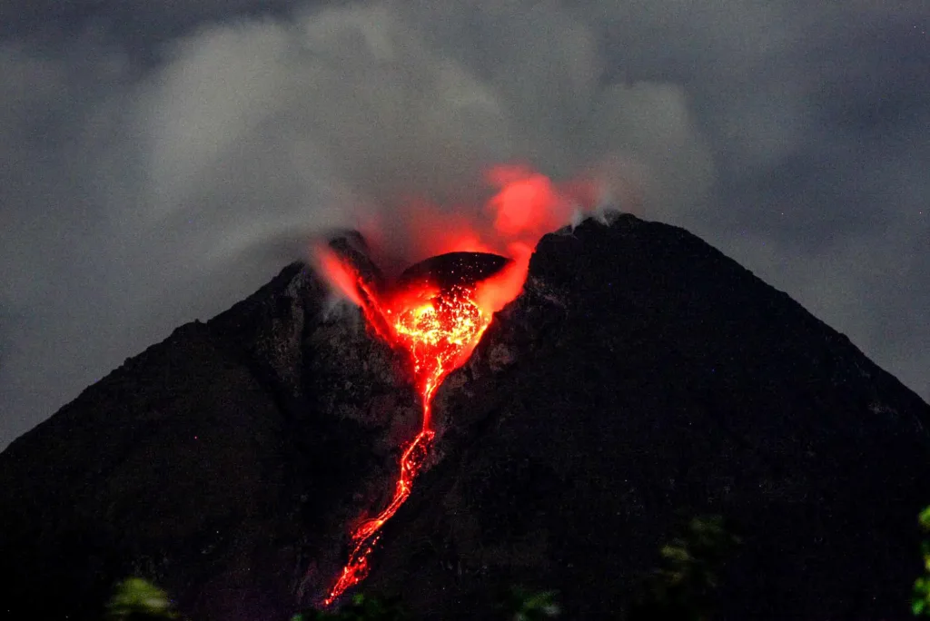
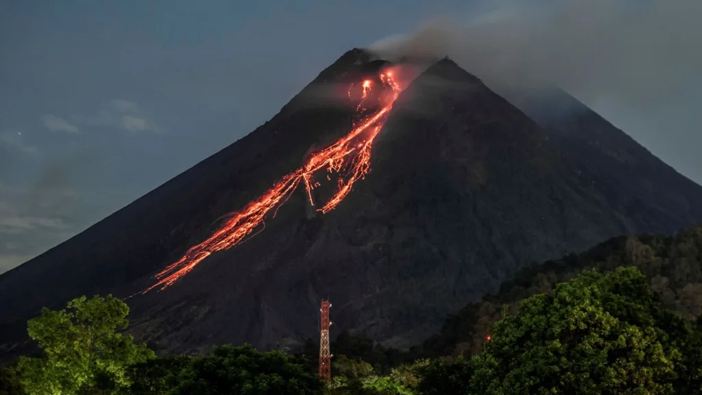
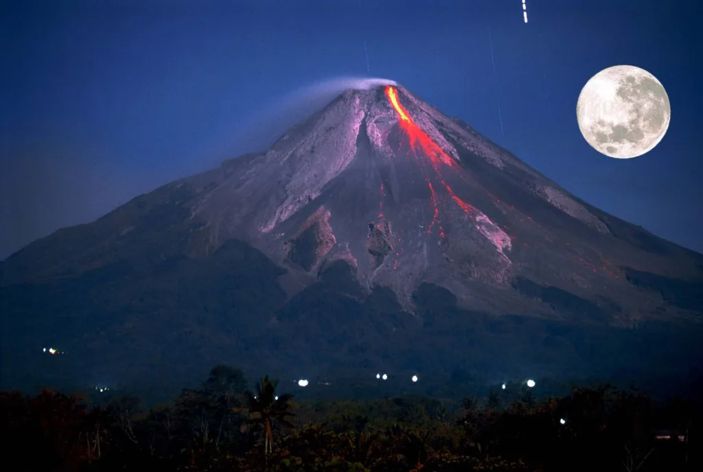
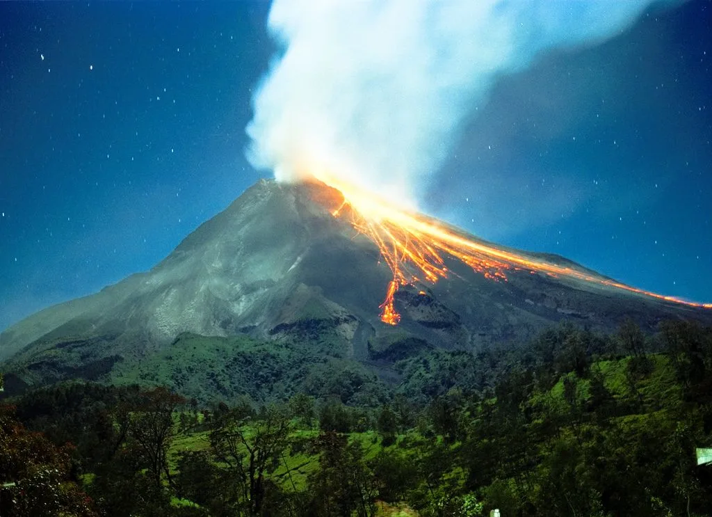
Merapi has a steep-sided conical shape typical of stratovolcanoes and reaches an elevation of about 2,930 meters (9,613 feet) above sea level. It is composed of layers of volcanic rock, ash, and lava flows that have accumulated over thousands of years. The eruptions of Merapi are often explosive and can produce pyroclastic flows—fast-moving clouds of superheated gas, ash, and volcanic debris that can be extremely destructive.
Significance in Terms of Geology and History:
- Geological Significance: Merapi’s activity is linked to the subduction zone where the Indo-Australian Plate is being forced beneath the Eurasian Plate. As the subducting oceanic plate descends into the Earth’s mantle, it melts and forms magma, which then rises to the surface, fueling volcanic activity. This process is responsible for the creation of many volcanoes in Indonesia, including Merapi.
- Historical Significance: The history of Merapi’s eruptions is extensive and marked by its impact on the local population. Eruptions have been documented for centuries and have caused both loss of life and extensive damage to infrastructure and agriculture. The volcanic slopes of Merapi are densely populated due to the fertile soil, making the region highly vulnerable to the volcano’s activity.
- Cultural and Spiritual Significance: The local Javanese people have a deep cultural and spiritual connection to Merapi. The volcano is considered sacred and holds a prominent place in local myths and traditions. It is believed that the spirits of the volcano must be appeased to prevent eruptions.
- Scientific Study: Merapi is closely monitored by volcanologists and researchers due to its potential for significant eruptions. Monitoring includes the use of seismometers, gas measurements, and remote sensing to detect changes in volcanic activity and predict eruptions. Studying Merapi’s behavior contributes to a better understanding of volcanic processes and helps in preparing for potential hazards.
In summary, Merapi Volcano is a highly significant geological and cultural feature in Indonesia. Its geological activity results from the collision of tectonic plates, and its historical and cultural importance is intertwined with the lives of the local population. Regular monitoring and study of Merapi contribute to both scientific knowledge and disaster preparedness efforts.
Geology of Merapi Volcano
Location and Tectonic Setting: Merapi Volcano is situated on the southern part of the island of Java in Indonesia, near the city of Yogyakarta. It is part of the Pacific Ring of Fire, a horseshoe-shaped area in the Pacific Ocean known for its high volcanic and seismic activity. This activity is a result of the complex interactions between various tectonic plates in the region.

Merapi is located at the convergent boundary of two tectonic plates: the Indo-Australian Plate and the Eurasian Plate. The Indo-Australian Plate is subducting beneath the Eurasian Plate, creating a subduction zone. As the oceanic crust of the Indo-Australian Plate descends into the mantle, it begins to melt, generating magma that rises through the overlying crust to form volcanoes like Merapi.
Volcanic Features and Formations: Merapi is a stratovolcano, also known as a composite volcano, which is characterized by its steep-sided, conical shape formed by layers of lava flows, volcanic ash, and other volcanic debris. The volcano has undergone numerous eruptions over its history, leading to the construction of its complex structure. Some key features include:
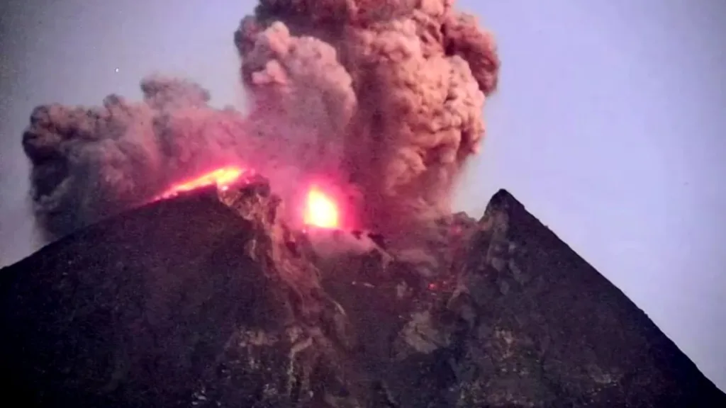
- Central Vent: At the summit of Merapi, there is a central vent from which eruptions typically occur. This vent can release a variety of volcanic materials, including ash, gases, and lava.
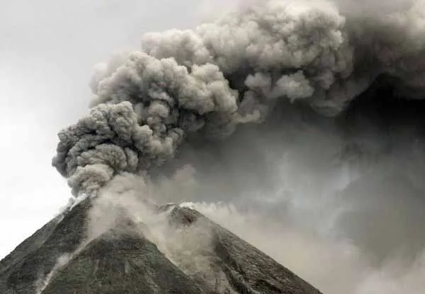
- Pyroclastic Flows: Merapi is known for producing highly destructive pyroclastic flows during its eruptions. These fast-moving clouds of hot gases, ash, and volcanic debris can travel down the volcano’s slopes at high speeds, posing a significant hazard to nearby communities.
- Lava Flows: The volcano has produced lava flows of various compositions, which have contributed to the growth of its cone. The lava flows can be both effusive (slow-moving) and explosive, depending on the magma’s viscosity and gas content.
Composition of Magma and Volcanic Rocks: The composition of magma and volcanic rocks from Merapi provides insight into the geological processes occurring beneath the surface:
- Magma Composition: The magma beneath Merapi is primarily intermediate to high in silica content, making it viscous and prone to explosive eruptions. The magma is rich in volatiles such as water vapor, carbon dioxide, and sulfur dioxide, which contribute to the explosiveness of eruptions.
- Volcanic Rocks: The volcanic rocks produced by Merapi are primarily andesite and dacite. These rocks form as a result of the crystallization of magma beneath the surface. Andesite is characterized by its intermediate composition, containing moderate amounts of silica, while dacite has a higher silica content. Both rock types are associated with explosive eruptions due to their high viscosity.
In summary, Merapi Volcano’s geology is shaped by its location at a convergent plate boundary, resulting in explosive eruptions and the formation of a stratovolcano. The composition of its magma and volcanic rocks contributes to the volcano’s hazardous nature, with the potential for pyroclastic flows and other destructive phenomena.
Historical Eruptions of Merapi Volcano
Merapi Volcano has a long history of eruptions that have impacted the local communities and environment. Here are some major historical eruptions, along with their dates, magnitudes, impacts, and notable accounts:
- 2010 Eruption:
- Date: October-November 2010
- Magnitude: VEI (Volcanic Explosivity Index) 4
- Impact: This eruption was particularly significant, resulting in the evacuation of tens of thousands of people from the surrounding areas. Pyroclastic flows caused destruction in nearby villages, and ashfall affected a large area. The eruption led to the closure of airports and disrupted daily life in Central Java.
- 1994 Eruption:
- Date: November 1994
- Magnitude: VEI 2
- Impact: The 1994 eruption produced pyroclastic flows and lava flows, causing damage to infrastructure and forcing evacuations. Ashfall affected Yogyakarta and other populated areas.
- 1930 Eruption:
- Date: November 1930
- Magnitude: VEI 4
- Impact: The 1930 eruption was one of the deadliest in Merapi’s history. Pyroclastic flows and lahars (volcanic mudflows) caused the loss of thousands of lives and widespread devastation in surrounding areas.
- 1872 Eruption:
- Date: June 1872
- Magnitude: VEI 3
- Impact: The 1872 eruption produced pyroclastic flows and lahars, affecting local communities and resulting in fatalities.
- 1822 Eruption:
- Date: 1822
- Magnitude: VEI 4
- Impact: The 1822 eruption generated pyroclastic flows and lahars, causing significant damage and loss of life.
Impact on Local Communities and Environment:
The eruptions of Merapi have had profound effects on the local communities and environment. The volcanic activity has led to the loss of lives, destruction of homes and infrastructure, displacement of communities, and disruption of agriculture. The fertile slopes of the volcano attract settlement due to their agricultural potential, but this also exposes communities to volcanic hazards.
The eruptions have also triggered lahars—mudflows formed from volcanic debris mixing with water—which can inundate villages and destroy everything in their path. Ashfall from eruptions affects air quality, agriculture, and infrastructure over a wider region.
Notable Historical Accounts of Eruptions:
- The 1930 eruption of Merapi is particularly well-documented due to its devastating impact. It led to the tragic loss of life and was described in various historical records and survivor accounts.
- The 2010 eruption received significant media coverage due to its modern impact on densely populated areas. The evacuation efforts, response measures, and international attention highlighted the ongoing challenges posed by the volcano’s activity.
Patterns and Recurrence Intervals of Eruptions:
Merapi’s eruptions do not follow a strict pattern, but they do exhibit a tendency for recurrent explosive activity. The volcano typically experiences periods of relative calm followed by more active phases. The recurrence intervals between major eruptions can vary, ranging from decades to centuries.
Volcanologists study the historical records, geological deposits, and monitoring data to assess potential eruption scenarios and provide early warnings to at-risk communities. Despite the unpredictability of exact eruption timing, the volcano’s history informs hazard assessments and disaster preparedness efforts in the region.
Monitoring and Early Warning Systems for Merapi Volcano
Given the potential hazards associated with Merapi Volcano’s eruptions, extensive monitoring and early warning systems are in place to provide timely information to authorities and local communities. These systems aim to mitigate risks, save lives, and minimize damage. Here are some of the key monitoring and early warning components for Merapi:
- Seismic Monitoring: Seismometers are deployed around the volcano to detect ground vibrations caused by volcanic activity. Changes in seismic patterns, such as increased frequency or amplitude of earthquakes, can indicate magma movement and potential eruptions.
- Gas Monitoring: Gas emissions from the volcano, including sulfur dioxide (SO2) and other volatile gases, are measured. Increases in gas emissions can be indicative of rising magma and impending eruptions.
- Deformation Monitoring: Instruments like GPS and tiltmeters track ground deformation caused by magma movement. Sudden changes in ground shape may signal imminent eruptions.
- Thermal Monitoring: Infrared cameras detect changes in surface temperature on the volcano’s slopes, which can indicate the movement of magma towards the surface.
- Remote Sensing: Satellite imagery and aerial surveys provide a broader perspective on volcanic activity, including ash plumes, lava flows, and changes in the volcanic landscape.
- Volcanic Tremor Analysis: Volcanic tremors, which are continuous low-frequency ground vibrations, can indicate the movement of magma and the potential for an eruption.
Early Warning and Communication:
Early warning systems are crucial for alerting communities and authorities about imminent volcanic activity. The information collected from monitoring is analyzed by volcanologists to determine the level of risk and potential impact. This information is then communicated through various channels:
- Alert Levels: Volcanic alert levels are used to communicate the current state of the volcano’s activity. These levels typically range from normal (no eruption imminent) to various stages of alertness, with corresponding recommendations for evacuation and preparedness.
- Community Education: Local communities are educated about volcanic hazards, evacuation routes, and safety protocols. This helps residents understand the risks and take appropriate actions when necessary.
- Emergency Plans: Local and national authorities develop and regularly update emergency response plans. These plans outline steps to take in the event of an eruption, including evacuation procedures and resource allocation.
- Early Warning Centers: Dedicated centers, equipped with real-time monitoring data and communication facilities, coordinate information dissemination and response efforts during volcanic crises.
- Public Communication: Radio, TV, social media, and text messages are used to broadcast alerts, updates, and evacuation instructions to the public.
Challenges and Successes:
While monitoring and early warning systems have improved significantly over the years, challenges remain, such as maintaining equipment, ensuring effective communication, and managing public responses. However, these systems have proven effective in saving lives during eruptions, as seen in the successful evacuations and preparations that took place during the 2010 eruption.
In summary, monitoring and early warning systems for Merapi Volcano involve a combination of scientific techniques, data analysis, communication strategies, and community engagement. These systems play a crucial role in reducing the risks associated with the volcano’s potentially hazardous eruptions.
Scientific Research and Study of Merapi Volcano
Scientific research and study of Merapi Volcano are essential for understanding its behavior, predicting eruptions, assessing hazards, and mitigating risks to surrounding communities. Various disciplines and methodologies contribute to a comprehensive understanding of the volcano’s complex processes. Here are some aspects of scientific research related to Merapi:
- Volcanology:
- Volcanic Processes: Researchers study the mechanics of magma ascent, eruption triggers, and the formation of various volcanic products such as lava flows, pyroclastic flows, and ash clouds.
- Magma Composition: Analyzing the chemical composition of erupted materials provides insights into the source of magma, its evolution, and the potential for explosive eruptions.
- Monitoring Techniques:
- Seismicity: Seismometers detect ground vibrations, helping to identify patterns associated with volcanic activity and providing information about magma movement.
- Gas Emissions: Monitoring gases like sulfur dioxide helps track magma movement, assess eruption potential, and estimate the quantity of volcanic emissions.
- Ground Deformation: Instruments such as GPS and satellite imagery measure ground deformation caused by magma movement and identify areas of uplift or subsidence.
- Modeling and Simulation:
- Numerical Models: Computer models simulate volcanic processes, aiding in understanding eruption dynamics, forecasting ash dispersion, and predicting potential hazards.
- Risk Assessment: Researchers develop models to assess potential hazards and vulnerabilities, considering factors like eruption scenarios, population density, and infrastructure location.
- Geological Studies:
- Volcanic Deposits: Analyzing the geological layers from past eruptions provides information about the volcano’s history, eruption styles, and recurrence intervals.
- Lahar Studies: Understanding lahars’ behavior and potential pathways helps predict their impacts on downstream areas.
- Remote Sensing and Imaging:
- Satellite Data: Satellite imagery monitors surface changes, identifies thermal anomalies, and tracks ash plumes, aiding in eruption detection and assessment.
- Community Engagement:
- Social Sciences: Researchers study how communities perceive volcanic risks, respond to warnings, and interact with authorities during volcanic crises. This information helps tailor risk communication strategies.
- Disaster Preparedness:
- Emergency Plans: Scientific research informs the development of evacuation plans, emergency response strategies, and infrastructure resilience in at-risk areas.
- Evacuation Simulations: Simulating evacuation scenarios based on eruption forecasts helps optimize evacuation routes and resources.
- International Collaboration:
- Data Sharing: International collaborations and data-sharing agreements enable researchers from various countries to contribute to the study of Merapi and similar volcanoes.
By combining insights from these various aspects of scientific research, experts can make more informed decisions about hazard assessment, emergency response, and public safety. The knowledge gained from studying Merapi contributes not only to understanding volcanic processes but also to advancing the broader field of volcanology and disaster management.
Conclusion
In conclusion, Merapi Volcano stands as a powerful testament to the intricate interplay between geological processes and human history. Its location within the Pacific Ring of Fire and at the convergent boundary of tectonic plates has endowed it with the potential for both breathtaking beauty and devastating destruction. Its geological composition, characterized by andesite and dacite magma, has fueled its explosive eruptions that have shaped the surrounding landscape over time.
Merapi’s historical significance is deeply intertwined with the lives and cultures of the local Javanese people. It has been both a source of fertility for the fertile slopes it has created and a source of danger due to its frequent eruptions. The eruption accounts throughout history serve as a somber reminder of the unpredictable and perilous nature of volcanic activity, impacting communities, livelihoods, and landscapes alike.
The importance of continued monitoring and preparedness cannot be overstated. The advancements in modern science and technology have allowed us to track the subtlest changes beneath the surface and anticipate the potential hazards Merapi poses. Monitoring systems, including seismic instruments, gas measurements, and deformation analysis, provide essential data for early warning systems that have the potential to save countless lives.
Preparedness measures, from community education to the development of evacuation plans, play a critical role in minimizing the impact of Merapi’s eruptions. By maintaining a close watch on its behavior, scientists and authorities can make informed decisions that keep communities safe and informed. The lessons learned from Merapi’s past, coupled with ongoing scientific research, underscore the imperative to remain vigilant, adaptable, and responsive to the ever-changing dynamics of this remarkable and unpredictable force of nature.

")


