")


Amber

Amber is a fascinating organic gemstone that has captured human fascination for millennia. It’s not a mineral, but rather a fossilized resin from ancient trees. This unique material has played a significant role in various cultures and has been used for both decorative and practical purposes.
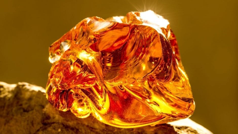

Amber is a solidified resin that originated from coniferous trees, primarily in the Pinaceae family, during prehistoric times. Resin is the sticky substance that oozes from trees when they are wounded, serving as a protective mechanism against pests and pathogens. Over time, this resin can become buried and undergo a process of fossilization, transforming into amber.
Amber’s composition is primarily carbon, hydrogen, and oxygen, with traces of sulfur. It’s relatively lightweight and can vary in color from pale yellows and oranges to darker reds and browns. The coloration is influenced by factors such as the type of tree it originated from, the presence of impurities, and the length of time it underwent fossilization.
Formation of Amber:
The journey of amber begins when resin flows from trees as a protective response to injuries. This resin can trap various organic materials, such as insects, plant matter, and even air bubbles. Over time, the resin can fall to the ground, get carried by water, and eventually become buried by sediment. The pressure and heat from geological processes cause the resin to polymerize, gradually solidifying it into amber.
The process of amber formation is a slow one, taking millions of years. During this time, the resin undergoes chemical changes that contribute to its unique properties, including its distinct transparency and ability to hold preserved organisms.
Significance and Historical Uses:
Amber has held cultural and commercial significance for countless societies throughout history. Its captivating appearance, often resembling drops of sunlight trapped within a stone, led many civilizations to attribute it with mystical and protective qualities. Amber was frequently used in jewelry and amulets for adornment and as a symbol of status.
In ancient times, amber was traded along extensive routes, forming part of the fabled Amber Road that connected Northern Europe to the Mediterranean. It was particularly valued by the ancient Greeks and Romans, who associated it with the gods and believed it had healing properties.
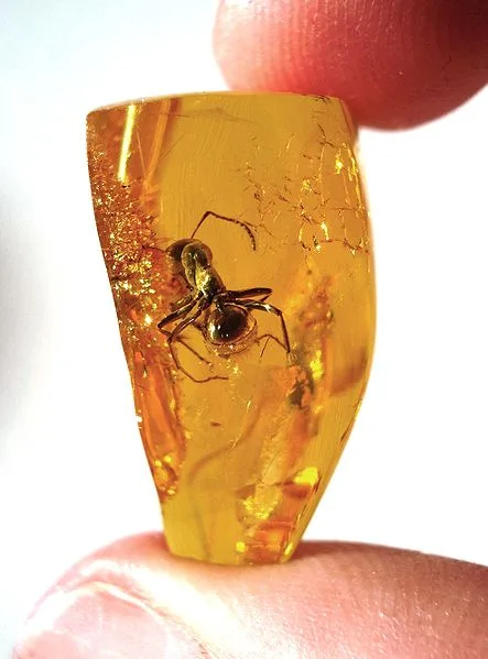
Amber’s ability to preserve prehistoric organisms is one of its most remarkable traits. Insects, plants, and even small animals have been found perfectly preserved within amber, providing valuable insights into ancient ecosystems and the evolution of life on Earth.
In more recent times, amber continues to be cherished for its aesthetic and historic value. It’s used in various forms of jewelry, carvings, and decorative art. Additionally, modern science has utilized the fossilized inclusions in amber to study the biology of ancient organisms and gain a better understanding of Earth’s past.
In conclusion, amber is a captivating gemstone that offers a window into the ancient past. Its formation from fossilized tree resin, coupled with its historical significance and uses, makes it a truly unique and cherished material in both cultural and scientific realms.
Geological Formation

The process through which tree resin transforms into amber is a complex one, involving several stages over millions of years. Here’s a detailed breakdown of the formation process:
- Resin Exudation: When certain types of trees, particularly conifers in the Pinaceae family, experience injuries or stress, they release resin as a defense mechanism. This resin is a sticky substance that oozes from the tree’s wounds, sealing them and protecting against pests, pathogens, and environmental stressors.
- Transport and Accumulation: The resin can flow down the tree’s bark and collect on the ground or other surfaces. Over time, various materials such as insects, plant debris, and air bubbles might get trapped within the sticky resin.
- Burial: If the resin isn’t disturbed or degraded, it can become buried by sediment or transported by water, eventually reaching riverbeds, lakes, or coastal areas. Burial prevents the resin from being exposed to air, which helps in preserving its organic components.
- Diagenesis: Under the pressure and heat of geological processes, the resin undergoes diagenesis, a series of chemical changes. Polymerization occurs, where the volatile components of the resin evaporate, and the remaining complex organic compounds bond together, forming a solid substance.
- Hardening and Fossilization: Over time, the polymerized resin hardens further, and its structure becomes more crystalline. The process of fossilization involves the infiltration of minerals from surrounding sediments, which can contribute to the final color and appearance of the amber.
- Tectonic Movements and Uplift: Geological processes such as tectonic movements, erosion, and uplift bring amber deposits closer to the surface. This can expose them to weathering and erosion, allowing them to be discovered by humans.
Factors Influencing Preservation and Transformation:
Several factors influence the preservation and transformation of resin into amber:
- Type of Resin: Different tree species produce resins with varying chemical compositions. Some resins are more conducive to amber formation due to their higher levels of polymerizable compounds.
- Environmental Conditions: The conditions of the environment where the resin is deposited play a role. Burial in low-oxygen, anaerobic conditions helps prevent decay and decomposition.
- Pressure and Temperature: The pressure and temperature experienced by the buried resin influence the speed and extent of its polymerization and hardening.
- Mineral Content: The minerals present in the surrounding sediments can infiltrate the resin during fossilization, affecting its appearance and properties.
- Time: Amber formation is a slow process, taking millions of years. The longer the resin is buried, the more extensive the polymerization and fossilization processes become.
Geological Time Periods and Major Amber Deposits:
Amber deposits are associated with specific geological time periods, and they offer insights into the ancient environments and ecosystems of those times. Some major amber deposits include:
- Baltic Amber (Eocene): The most famous and commercially valuable amber comes from the Baltic region (Northern Europe). The majority of Baltic amber is dated to the Eocene epoch, which spanned from about 56 to 33.9 million years ago.
- Dominican Amber (Miocene to Pleistocene): Found in the Dominican Republic and neighboring areas, this amber ranges in age from the Miocene (about 23 to 5.3 million years ago) to the Pleistocene (about 2.6 million to 11,700 years ago).
- Mexican Amber (Miocene): Mexican amber is primarily from the mid-Miocene period, around 15 to 23 million years ago, and is found in regions like Chiapas.
These major amber deposits provide windows into diverse ancient ecosystems, offering scientists valuable insights into the flora, fauna, and climatic conditions of the past.
Properties

Physical Properties:
- Hardness: Amber ranks around 2 to 3 on the Mohs scale of hardness, which means it is relatively soft compared to other gemstones and can be scratched easily by harder materials.
- Density: Amber is relatively lightweight, with a density ranging from 1 to 1.2 g/cm³.
- Transparency: Amber is often transparent to translucent, allowing light to pass through it with varying degrees of clarity.
- Luster: Amber has a resinous or vitreous luster when polished, giving it a shiny appearance.
- Electrostatic Properties: Amber can develop static electricity when rubbed, a phenomenon known as “electrostatic charging.” This property was famously observed by the ancient Greeks, who named it “elektron,” which eventually led to the term “electricity.”
Chemical Properties:
- Composition: Amber is primarily composed of carbon, hydrogen, and oxygen, with minor amounts of sulfur. The complex organic compounds in amber result from the polymerization of the original tree resin.
- Volatility: Over time, volatile components in the resin evaporate, leaving behind more stable compounds that contribute to amber’s preservation.
- Flammability: Amber is flammable and can burn with a smoky, aromatic flame due to its organic composition.
Types of Amber
Amber can be classified into different types based on its origin, characteristics, and geological age. Some notable types include:
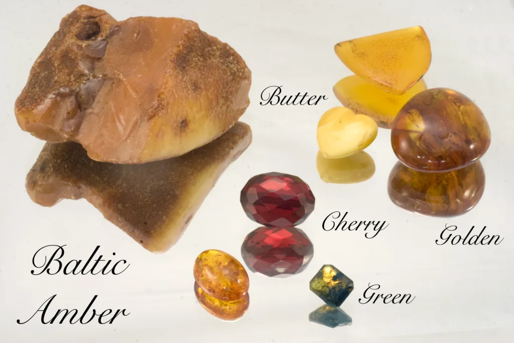
- Baltic Amber: Originating primarily from the Baltic Sea region (Northern Europe), Baltic amber is one of the most well-known and sought-after types. It’s famous for its rich colors, clarity, and the wide range of preserved inclusions it contains.
- Dominican Amber: Found in the Dominican Republic and surrounding areas, Dominican amber is known for its wide array of colors and inclusions. It tends to be more transparent than Baltic amber and can range from pale yellow to deep red.
- Succinite: A term often used to refer to Baltic amber due to its scientific name, Succinum. It’s derived from the Latin word for amber, “succinum.”
- Burmite: Hailing from Myanmar (Burma), Burmite is amber from the Cretaceous period, known for its ancient inclusions. It can have a wide range of colors and is sometimes cloudy due to its geological age.
- Mexican Amber: This amber comes from Mexico, particularly the Chiapas region. It can vary in color from pale yellow to deep red and often contains a diversity of inclusions.
Variations in Color, Transparency, and Inclusions:
Amber displays a captivating range of variations:
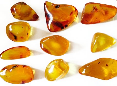
- Color: Amber can exhibit various colors, including shades of yellow, orange, red, brown, and even rare greens and blues. The color is influenced by factors such as the resin’s original composition, the presence of impurities, and the conditions of fossilization.
- Transparency: The transparency of amber can vary widely, from nearly opaque to highly transparent. This impacts how much light passes through the gemstone, affecting its visual appeal.
- Inclusions: One of the most remarkable features of amber is the preserved organic inclusions trapped within it. These inclusions can include insects, plant fragments, air bubbles, and even small vertebrates. These trapped relics provide valuable insights into ancient ecosystems and life forms.
In conclusion, amber’s physical and chemical properties, along with its diverse types, colors, transparency levels, and inclusions, make it a truly unique gemstone that offers both aesthetic beauty and scientific significance.
Amber as a Gemstone
Amber holds a special place in the world of gemstones due to its organic origin, unique properties, and historical significance. While not a mineral like many other gemstones, its beauty and the captivating inclusions it can contain make it highly desirable for jewelry and decorative purposes.
Value Factors for Amber as a Gemstone:
The value of amber as a gemstone is influenced by several factors:
- Color: Color is a primary determinant of amber’s value. Clear, vibrant, and rich colors, such as deep oranges, reds, and yellows, are highly prized. Rarer colors, like green and blue, are even more valuable.
- Clarity: Clarity refers to the degree of transparency and the absence of significant internal flaws or fractures. Clear, transparent amber with minimal internal inclusions commands higher prices.
- Size: Larger pieces of amber are generally more valuable, as they provide more material for crafting jewelry and allow the inclusions to be better observed.
- Inclusions: While inclusions are often considered flaws in other gemstones, in amber, they can greatly enhance its value. The presence of well-preserved and interesting inclusions, such as insects or plant fragments, adds to the uniqueness and desirability of the gem.
- Color Variation: Amber with multiple colors or color zones can be particularly sought after. This “sunburst” effect, where the colors radiate from a central point, can enhance its visual appeal.
Cutting, Polishing, and Jewelry Settings:
The process of crafting amber into jewelry involves several steps:
- Cutting: Amber is relatively soft compared to other gemstones, so it can be easily cut and shaped. Skilled artisans cut raw amber pieces into various shapes such as cabochons, beads, pendants, and even intricately carved figurines.
- Polishing: After cutting, amber is polished to enhance its luster and translucency. Polishing brings out its natural shine, giving it a smooth and glossy appearance.
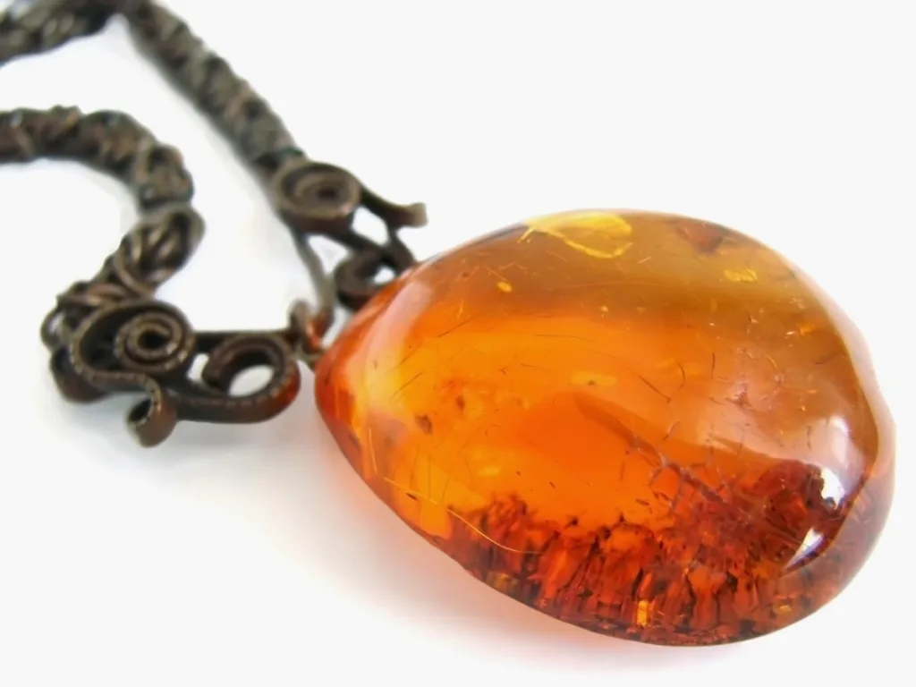
- Setting: Amber is often set in jewelry using traditional metal settings like sterling silver, gold, or even more contemporary materials. Bezel settings, which encircle the gem with a metal rim, are common for amber jewelry, as they offer protection and highlight the gem’s beauty.
- Design: Amber’s warm and earthy tones make it suitable for various jewelry styles, from traditional to modern. It’s used in rings, necklaces, bracelets, earrings, and even more elaborate statement pieces.
- Inclusion Display: In jewelry, craftsmen often design settings to showcase amber’s inclusions. Insects or other inclusions trapped within the gem can become central focal points of a piece, creating a unique and storytelling jewelry item.
- Enhancements: Amber is typically not treated or enhanced, as its natural beauty and historical significance are its main attractions.
In conclusion, amber’s status as a gemstone is distinguished by its natural origin, captivating inclusions, and historical allure. The value of amber is influenced by color, clarity, size, and the uniqueness of its inclusions. Its versatile use in jewelry and the craftsmanship involved in cutting, polishing, and setting ensure that amber remains a cherished and timeless gemstone choice.
Occurrence and Locations
Amber is found in various regions around the world, with different deposits offering unique qualities and characteristics. Here are some of the notable geographic locations where amber is found:
- Baltic Region (Northern Europe): The Baltic Sea area, encompassing countries like Poland, Russia, Lithuania, Latvia, and Estonia, is renowned for its Baltic amber. This amber is primarily from the Eocene epoch and is highly valued for its range of colors, transparency, and the exceptional preservation of inclusions, including insects and plant matter.
- Dominican Republic: The Dominican Republic and neighboring Caribbean countries are known for their deposits of Dominican amber. This amber is more diverse in color than Baltic amber and often contains a wide array of inclusions, showcasing ancient ecosystems and flora.
- Mexico (Chiapas): The Chiapas region in southern Mexico is a significant source of Mexican amber. This amber can vary in color from pale yellow to deep red and can contain intriguing inclusions. It’s often used in jewelry and artistic carvings.
- Myanmar (Burma): Burmite, amber from Myanmar, is of Cretaceous age, making it some of the oldest known amber. It’s known for its ancient inclusions and can be cloudy due to its geological age.
- Canada: Amber deposits have also been discovered in Canada, particularly in the province of Alberta. This amber is known for preserving a variety of prehistoric insects and plant matter.
- Ukraine: Amber deposits are found in the Rivne region of Ukraine. Ukrainian amber, like Baltic amber, dates back to the Eocene epoch and is valued for its quality and preservation of inclusions.
- Italy: The Sicilian amber, found in Italy, dates back to the Miocene epoch and is known for its unique blue color due to the presence of anthracene.
- Lebanon: Lebanese amber, also from the Cretaceous period, is another ancient source. It is valued for its well-preserved inclusions and is considered among the oldest ambers.
- Indonesia: Amber deposits have been found in Indonesia, including Sumatra and Borneo. Indonesian amber, also known as Borneo amber, is relatively less studied compared to other deposits.
- New Zealand: A rare type of amber known as kauri gum is found in New Zealand. Kauri gum is derived from the resin of kauri trees and is valued for its use in jewelry and decorative objects.
These are just a few examples of the geographic locations where amber is found. Each deposit has its own geological history, unique characteristics, and inclusions that provide insights into the ancient world and ecosystems. Amber’s global presence has contributed to its rich cultural, scientific, and commercial significance.