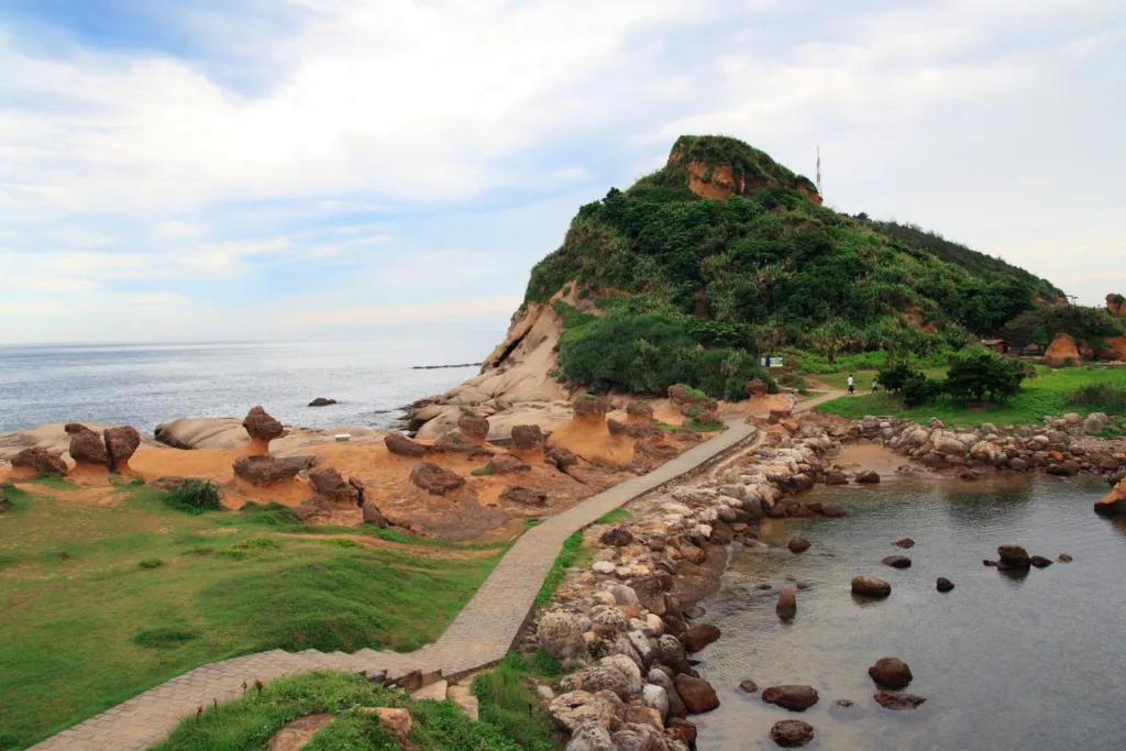
Yehliu Geopark is a renowned geological wonder located on the northern coast of Taiwan, specifically in the Wanli District of New Taipei City. It covers an area of approximately 1,700,000 square meters and is known for its unique and captivating rock formations, which have been shaped over millions of years by the forces of nature. Yehliu Geopark is situated along the beautiful and rugged coastline of the northern tip of Taiwan, making it a popular tourist destination and a site of significant geological interest.
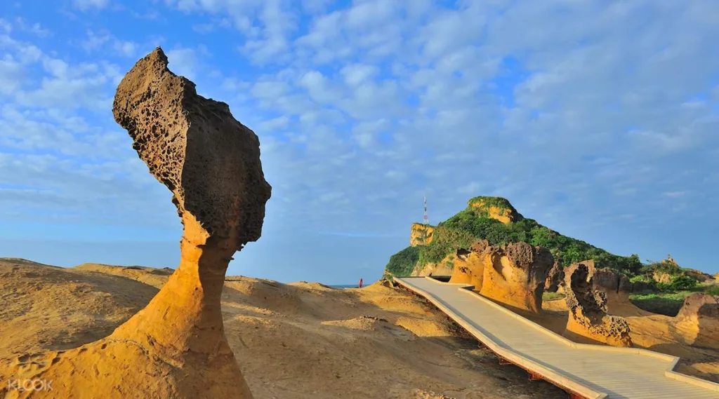
Significance and UNESCO Global Geopark Status: Yehliu Geopark holds great significance in the field of geology and earth sciences due to its exceptional rock formations. The park is home to various types of geological features, with the most famous being the “Queen’s Head” rock, which resembles the profile of a queen’s head and is considered the park’s iconic landmark. Other notable formations include the “Fairy Shoe,” the “Ginger Rocks,” and the “Candle Rocks,” among many others.
The significance of Yehliu Geopark lies in its ability to showcase various geological processes and phenomena, such as weathering, erosion, and sedimentation, which have sculpted these unique rock formations. These processes have occurred over millions of years, offering valuable insights into the Earth’s geological history.
In recognition of its geological importance and the need to conserve and promote its unique features, Yehliu Geopark has been designated as a UNESCO Global Geopark. This prestigious status is awarded to sites around the world that possess exceptional geological heritage and promote geological education, research, and sustainable tourism. As a UNESCO Global Geopark, Yehliu Geopark is committed to preserving its geological treasures, providing educational opportunities, and offering a memorable experience for visitors interested in the Earth’s history and natural beauty.
Visitors to Yehliu Geopark can explore the diverse rock formations, learn about the geological processes that shaped them, and appreciate the stunning coastal scenery, making it both a scientific and recreational destination of global significance.
Geological Features
Yehliu Geopark is renowned for its fascinating geological features, which have been shaped by various natural processes over millions of years. Some of the prominent geological features found in the park include:
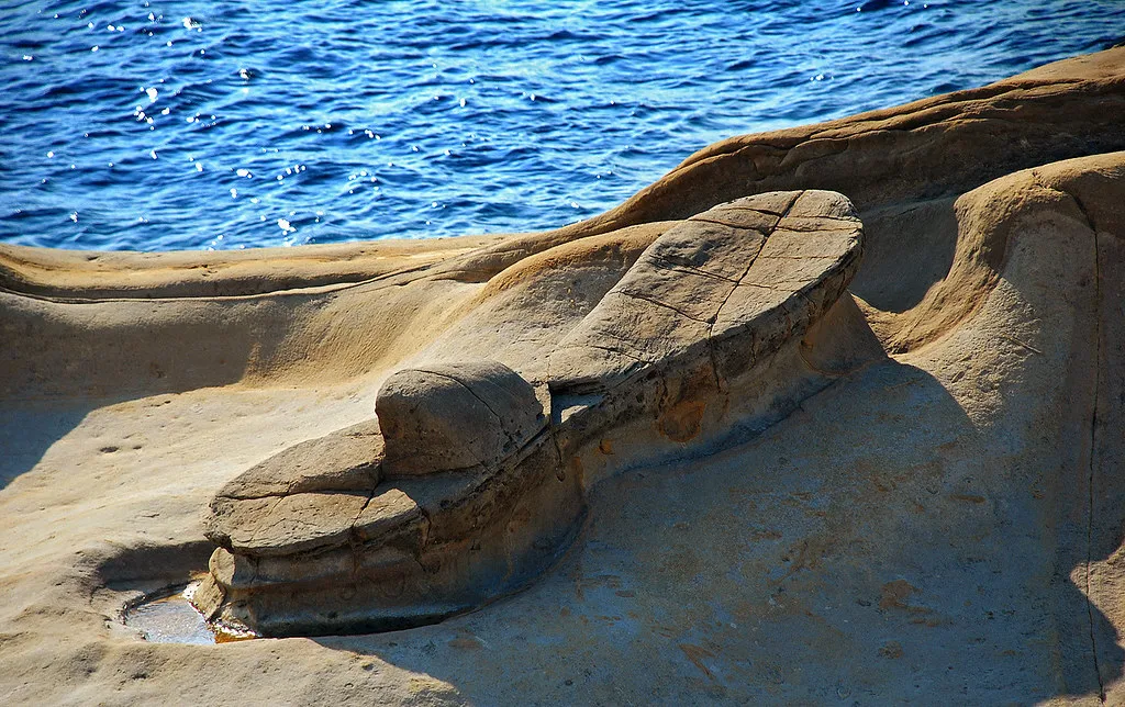
Queen’s Head (女王頭)
Queen’s Head (女王頭): The Queen’s Head is the most famous and iconic rock formation in Yehliu Geopark. It resembles the profile of a queen’s head, with a slender neck and distinct facial features. Erosion and weathering have sculpted this rock into its unique shape, and it has become a symbol of the park.
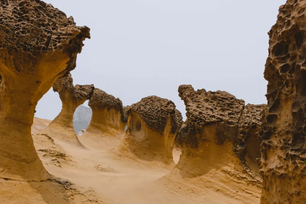
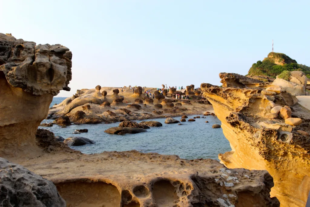
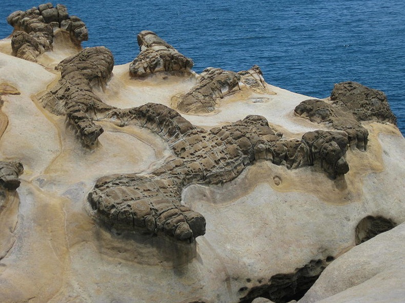
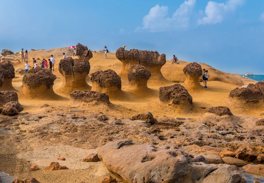
Mushroom Rocks (石頭公園)
Mushroom Rocks (石頭公園): These rock formations resemble mushrooms with their distinctive cap-like shapes. Erosion has worn away the softer rock layers, leaving behind the more resistant top portions, creating the mushroom-like appearance.
Fairy Shoe (仙女鞋)
Fairy Shoe (仙女鞋): The Fairy Shoe is a rock formation that remarkably resembles a high-heeled shoe. It is the result of differential erosion, where softer rock layers have been gradually eroded away, leaving behind this intriguing and delicate structure.
Ginger Rocks (姜石群)
Ginger Rocks (姜石群): The Ginger Rocks are a group of columnar basalt formations that resemble stacks of ginger. These formations were created through the cooling and solidification of lava flows, resulting in hexagonal columns.
Candle Rocks (蠟燭石)
Candle Rocks (蠟燭石): Candle Rocks are tall, thin columns of rock that look like candles. They are another example of columnar basalt formations created by lava cooling and fracturing into hexagonal shapes.
Sea Candles (海蠟燭): These are similar to Candle Rocks but are shorter and more stubby. They appear as if they were once candles but have partially melted, giving them a unique and interesting appearance.
Beehive Rocks (蜂巢石): The Beehive Rocks resemble a cluster of beehives stacked on top of each other. These formations are the result of erosion and weathering processes acting on different layers of rock.
Dragon’s Head (龍頭): This rock formation resembles the head of a dragon emerging from the sea. It is a massive and imposing geological feature that adds to the park’s allure.
Divorce Rock (離婚石): The Divorce Rock is an intriguing formation where two rocks appear to be in the process of separating. It is a result of differential erosion, with the softer rock in between being eroded away more quickly than the surrounding rock.
Yehliu Harbor (野柳港): The coastal area of Yehliu Geopark itself is noteworthy, with its unique rock platforms, tide pools, and stunning coastal landscapes. It offers visitors a chance to observe ongoing geological processes and the interaction between the sea and land.
These geological features at Yehliu Geopark provide valuable insights into the Earth’s geological history and showcase the power of natural processes like erosion, weathering, and volcanic activity. Visitors can explore these formations while appreciating the beauty and wonder of nature’s sculptural artistry.
Formation Processes
The geological features found in Yehliu Geopark have been shaped by a variety of natural processes over millions of years. Here are the key formation processes responsible for creating these remarkable rock formations:
Erosion: Erosion is one of the primary forces at work in Yehliu Geopark. The constant action of wind, rain, and waves has gradually worn away the softer rock layers, leaving behind the more resistant and visually striking formations. Erosion processes include abrasion (mechanical weathering due to particle impacts), chemical weathering, and corrosion by sea salt.
Weathering: Weathering involves the breakdown of rocks into smaller particles due to exposure to the elements. In Yehliu Geopark, weathering processes, including freeze-thaw cycles and the expansion and contraction of rocks caused by temperature changes, contribute to the sculpting of the rocks into unique shapes.
Differential Erosion: Some of the most iconic formations, such as the Queen’s Head and the Fairy Shoe, are the result of differential erosion. This occurs when different rock layers erode at varying rates due to differences in hardness, composition, or resistance to weathering. Softer rock layers erode more quickly, creating the distinct shapes seen in these formations.
Lava Cooling and Columnar Basalt: Many of the rock columns in Yehliu Geopark, like the Candle Rocks and Ginger Rocks, were formed from basaltic lava flows. As the lava cooled and solidified, it contracted and fractured into hexagonal columns. Over time, these columns were exposed as the surrounding rock eroded away.
Tectonic Activity: The geological formations in the park are also influenced by tectonic activity. Taiwan is located near the boundary of the Eurasian and Philippine Sea tectonic plates, resulting in geological instability. Earthquakes and crustal movements can uplift and tilt rock layers, exposing them to the forces of erosion and weathering.
Marine Processes: Yehliu Geopark’s location along the coast exposes the rocks to the relentless action of the sea. Waves, tides, and saltwater corrosion contribute to shaping the coastal rock formations and tide pools. Marine organisms may also play a role in the weathering and shaping of rocks.
Time: Perhaps the most critical factor in the formation of these geological features is time. These processes have been occurring for millions of years, slowly sculpting the rocks into their present shapes and revealing the geological history of the area.
It’s important to note that the interplay of these processes, as well as the geological composition of the rocks themselves, has resulted in the wide variety of shapes and formations seen in Yehliu Geopark. The park serves as a natural laboratory where visitors can witness ongoing geological processes and marvel at the stunning results of millions of years of Earth’s evolution.
Visitor Experience
Visiting Yehliu Geopark offers a unique and captivating experience for tourists and nature enthusiasts. Here’s what you can expect when exploring this geological wonder:
Iconic Rock Formations: Yehliu Geopark is home to a plethora of iconic rock formations, each with its own distinct shape and character. The most famous of these is the Queen’s Head, but there are many others, such as the Mushroom Rocks, Fairy Shoe, Ginger Rocks, and Candle Rocks, to explore and admire. These formations provide excellent photo opportunities and are sure to leave a lasting impression.
Educational Opportunities: The park provides educational materials, exhibits, and guided tours to help visitors understand the geological processes that have shaped these remarkable formations over millions of years. You can learn about erosion, weathering, volcanic activity, and other geological phenomena that have contributed to the park’s unique landscape.
Coastal Scenery: Beyond the geological features, Yehliu Geopark offers stunning coastal views. The rugged coastline, with its rocky platforms and tide pools, provides a picturesque backdrop for your visit. You can take leisurely walks along the seaside trails and enjoy the fresh sea breeze.
Tide Pools: Exploring the tide pools at low tide is a popular activity at the park. These pools are teeming with marine life, including crabs, snails, and colorful sea anemones. It’s a fantastic opportunity for marine biology enthusiasts to observe and learn about coastal ecosystems.
Visitor Center: The visitor center within the park offers additional information about the geology, ecology, and history of the area. You can pick up maps, brochures, and get guidance from park staff to plan your visit effectively.
Nature Photography: Yehliu Geopark is a haven for nature photographers. The intricate rock formations, coastal landscapes, and the interplay of light and shadows create endless photography possibilities. It’s an ideal place to hone your photography skills or simply capture the beauty of the natural world.
Accessibility: The park has well-maintained walkways and viewing platforms, making it accessible to visitors of all ages and physical abilities. The trails are relatively easy to navigate, and there are signposts to guide you to the different geological formations.
Cultural Experience: Yehliu Geopark is situated in Taiwan, a country with a rich cultural heritage. After exploring the park, you can take the opportunity to experience local cuisine, interact with the friendly locals, and immerse yourself in Taiwanese culture.
Conservation: The park is dedicated to the conservation of its unique geological heritage and natural environment. Visitors can learn about conservation efforts and the importance of preserving these formations for future generations.
Visitor Amenities: Yehliu Geopark provides amenities such as restrooms, food vendors, and souvenir shops, ensuring that visitors have a comfortable and enjoyable experience during their visit.
When planning a visit to Yehliu Geopark, it’s a good idea to check the park’s operating hours, admission fees, and any special events or exhibitions that may be taking place. Exploring the park at a leisurely pace and taking the time to appreciate the geological wonders and coastal beauty will make for a memorable and enriching experience.
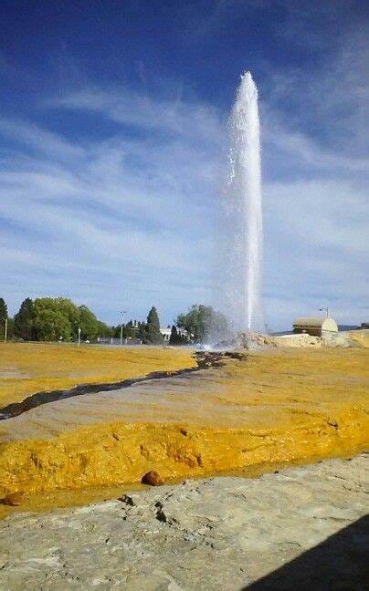
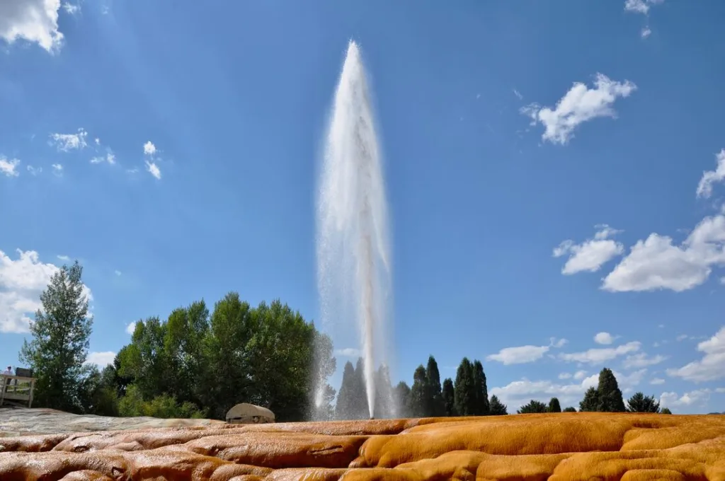
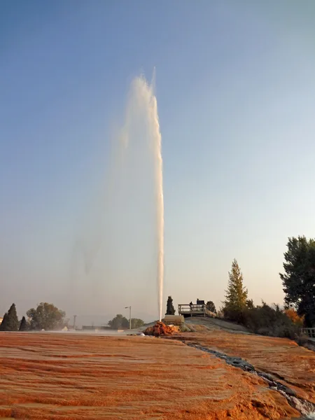
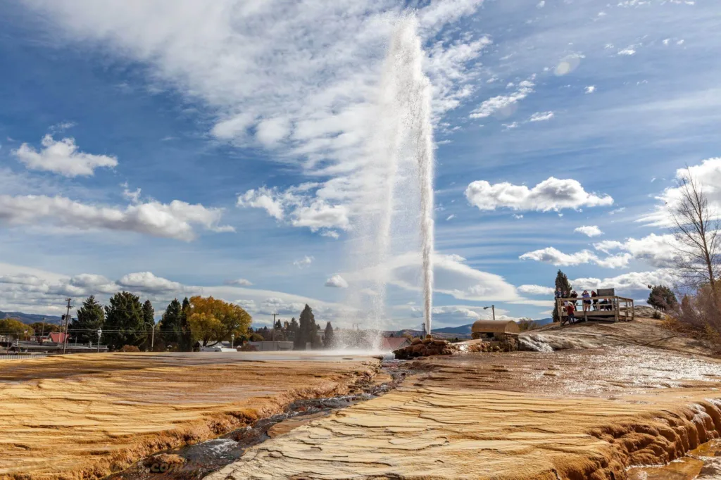
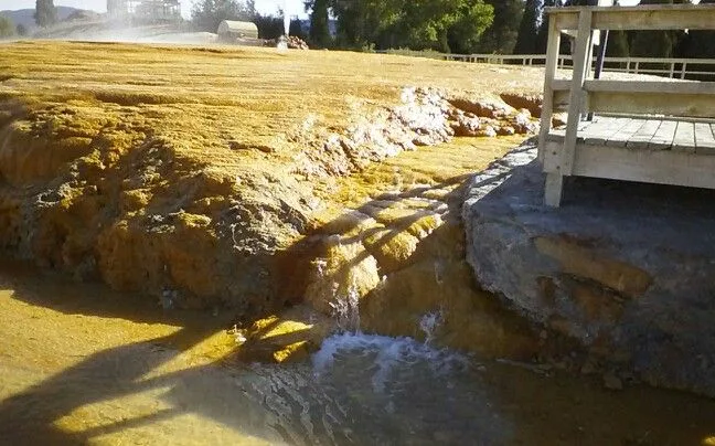
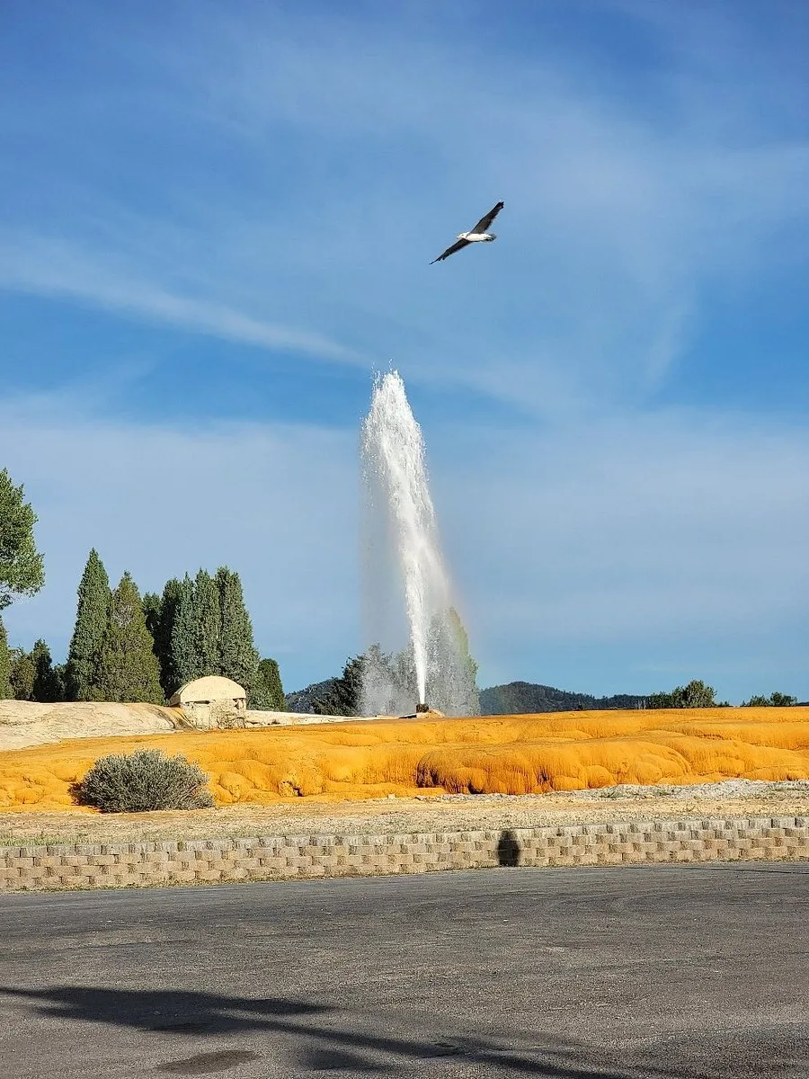
Soda Springs Geyser, located in Soda Springs, Idaho, USA, is a captivating natural wonder renowned for its distinctive features. This geothermal phenomenon stands out due to its carbonated water and intermittent eruptions, making it a fascinating attraction for visitors and a unique geological marvel in the United States.
Location: Soda Springs Geyser is situated in the town of Soda Springs, which is nestled in the southeastern part of the state of Idaho. Soda Springs is a charming community known for its picturesque landscapes and geothermal wonders, with the geyser being one of its most prominent natural attractions.
Unique Characteristics:
Carbonated Water: What truly sets Soda Springs Geyser apart from other geysers around the world is its carbonated water. Unlike most geysers that eject hot water and steam, this geyser’s eruptions are accompanied by effervescent bubbles due to the high levels of carbon dioxide gas dissolved in the water. The result is a spectacle that resembles a giant, natural soda fountain, complete with fizzing and bubbling water.
Intermittent Eruptions: Another intriguing feature of Soda Springs Geyser is its intermittent eruptions. While some geysers follow a predictable schedule, this geyser operates on a somewhat erratic timetable, making each eruption an unpredictable and exciting event for onlookers. Eruptions can vary in height and duration, ranging from a few feet to over a hundred feet in the air, and they can occur at irregular intervals, adding an element of surprise to the visitor’s experience.
In summary, Soda Springs Geyser in Soda Springs, Idaho, is a remarkable geothermal attraction known for its carbonated water and unpredictable, intermittent eruptions. Its unique characteristics make it a must-see natural wonder for anyone interested in geology and the fascinating phenomena that our planet has to offer.
Geological Backgroundof Soda Springs Geyser
The formation and activity of geysers like Soda Springs Geyser are the result of complex geological processes that involve the circulation of underground water, heat, and pressure. Here’s an overview of the geological background:
Formation of Geysers: Geysers are primarily found in geothermal areas where there is a source of underground heat, typically associated with volcanic activity or hot magma chambers beneath the Earth’s surface. The formation of a geyser typically involves the following key elements:
Underground Reservoir: Water from precipitation or surface sources seeps underground and accumulates in an underground reservoir. This water percolates deep into the Earth, where it is heated by the geothermal heat source.
Conduit System: A conduit system, which consists of narrow channels and fractures in the rock, allows the heated water to rise toward the surface. These conduits act as a plumbing system for the geyser.
Pressure Buildup: As water descends into the depths of the Earth and is heated, it becomes superheated steam or hot water. The confined space in the underground conduits leads to the buildup of pressure, preventing the water from boiling at its normal boiling point.
Eruption Trigger: Eruptions are triggered when the pressure in the underground system becomes too great, causing the water to explosively boil and escape to the surface, creating the characteristic geyser eruption.
Role of Underground Carbon Dioxide in Carbonation: Soda Springs Geyser’s unique feature of carbonated water is attributed to the presence of dissolved carbon dioxide (CO2) in the underground water. The carbonation process involves the following:
Carbon Dioxide Sources: In the case of Soda Springs Geyser, the carbon dioxide likely comes from various sources, including underground gas pockets and volcanic activity in the region. CO2 can dissolve into groundwater as it percolates through these sources.
Solubility: Carbon dioxide is highly soluble in water, especially under pressure. As the water seeps into the Earth’s depths, it absorbs significant amounts of CO2 from these sources, becoming carbonated.
Effervescence: When the pressurized, carbonated water erupts to the surface, the sudden release of pressure causes the dissolved CO2 to come out of solution, creating bubbles and effervescence. This is what gives Soda Springs Geyser its soda-like appearance during eruptions.
Geological Factors Contributing to the Geyser’s Activity: Several geological factors contribute to the activity and intermittent eruptions of Soda Springs Geyser:
Conduit System: The geyser’s plumbing system, consisting of underground conduits and fractures, plays a crucial role in channeling water and pressure to the surface. Variations in the shape and size of these conduits can impact the geyser’s eruption patterns.
Heat Source: The heat source, likely associated with volcanic activity or a magma chamber deep underground, provides the energy needed to heat the water and maintain the geyser’s activity.
Pressure Buildup: The accumulation of water and pressure in the underground reservoir, coupled with the unique properties of the conduit system, determines the timing and force of eruptions. Variations in pressure can lead to irregular eruptions.
In summary, geysers like Soda Springs Geyser form due to the interplay of geological factors, including heat sources, underground water reservoirs, and pressure buildup. The presence of dissolved carbon dioxide adds a distinctive characteristic to this geyser, resulting in carbonated water and effervescent eruptions. The geyser’s unique geological setting makes it a fascinating natural wonder.
Historical Significance
Soda Springs Geyser holds historical significance for several reasons:
Native American Traditions: The Soda Springs area, including the geyser, has been important in the history and culture of Native American tribes, particularly the Shoshone and Bannock tribes. They considered the geothermal features, including Soda Springs Geyser, to be sacred and used the warm, mineral-rich waters for various purposes, including bathing and healing rituals.
Early Exploration: The geyser was discovered by non-indigenous people during the westward expansion of the United States in the 19th century. Explorers and pioneers passing through the region were often amazed by the geyser’s unique carbonated water and intermittent eruptions, and it became a notable landmark along the Oregon Trail.
Tourism and Development: As the United States expanded westward, Soda Springs Geyser became a popular tourist attraction. In the late 19th and early 20th centuries, it attracted visitors from across the country who marveled at its natural beauty and unique geological features. This led to the development of the town of Soda Springs and the establishment of facilities to accommodate tourists.
Geological and Scientific Interest: Soda Springs Geyser has also been of interest to geologists and scientists studying geothermal phenomena. Its carbonated water and intermittent eruptions have provided valuable insights into the geological processes and chemistry associated with geysers and hot springs.
Historic Preservation: Recognizing the historical and cultural significance of the geyser, efforts have been made to preserve and protect Soda Springs Geyser and its surrounding area. It is now part of a park and historical site, ensuring that future generations can appreciate its natural beauty and cultural heritage.
In summary, Soda Springs Geyser has historical significance rooted in Native American traditions, early exploration, tourism, scientific research, and efforts to preserve its unique geological features. It serves as a reminder of the intersection of human history and the natural world in the American West.
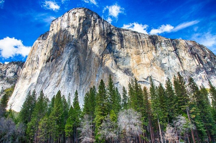
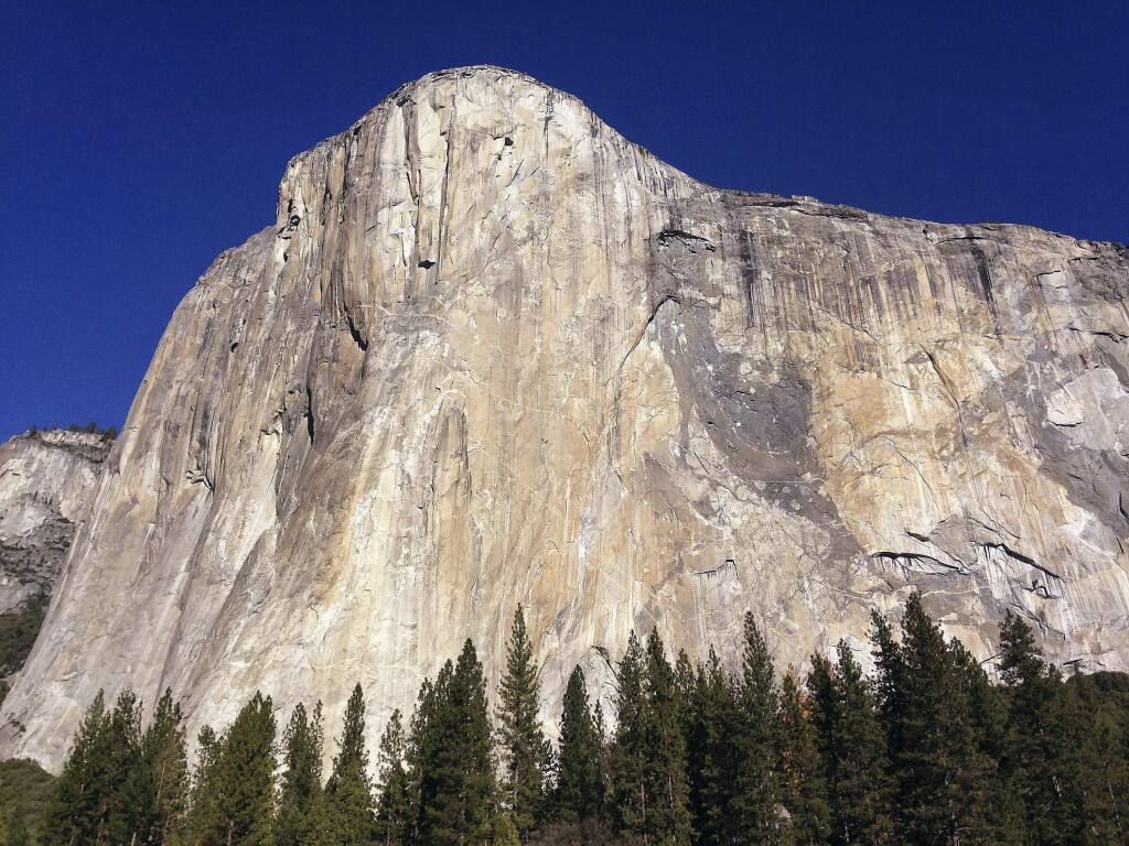
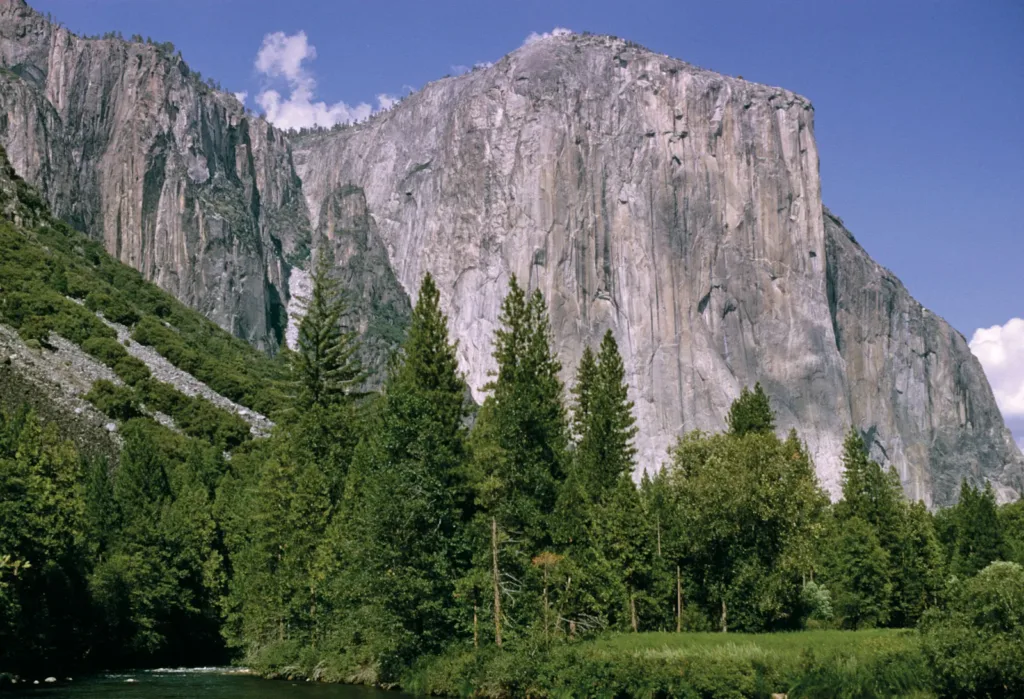
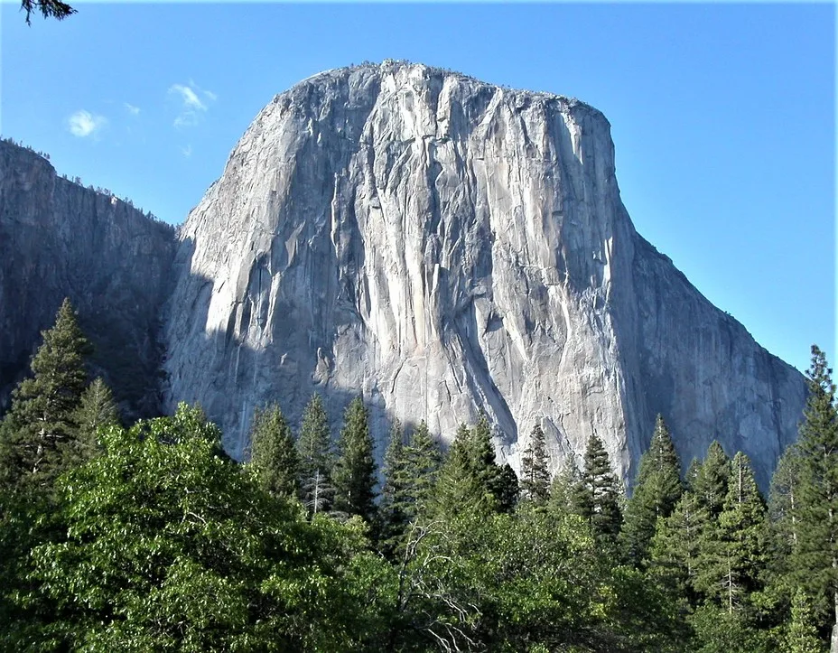
El Capitan is not only a remarkable geological formation but also a renowned natural landmark located within Yosemite National Park in California, USA. This iconic granite monolith rises almost vertically from the Yosemite Valley floor, towering approximately 3,000 feet (900 meters) above the valley. El Capitan is situated in the heart of the Sierra Nevada mountain range and is a prominent feature of the park’s dramatic landscape.
Geological Marvel: El Capitan is composed of a unique type of granite called El Capitan Granite, which is known for its exceptional strength and durability. Its sheer vertical face is the result of millions of years of geological processes, making it a captivating geological marvel and a subject of study for geologists and rock climbers alike.
Rock Climbing Mecca: El Capitan is world-famous for its challenging rock climbing routes. Climbers from around the globe are drawn to its towering cliffs, with routes that vary in difficulty and length. “The Nose” and “The Dawn Wall” are two of the most famous climbing routes on El Capitan, each known for its extreme difficulty and allure to experienced climbers.
Scenic Beauty: Beyond its geological and recreational significance, El Capitan’s majestic presence enhances the scenic beauty of Yosemite National Park. It is a popular spot for photographers, hikers, and nature enthusiasts, offering breathtaking views of the surrounding valley, waterfalls, and the iconic Half Dome rock formation in the distance.
Cultural and Historical Importance: El Capitan holds cultural and historical importance as well. Native American tribes, such as the Ahwahneechee, have long held the area as sacred, and its name has origins in their language. Additionally, the park’s history includes tales of early explorers and settlers who marveled at the imposing sight of El Capitan.
Conservation and Protection: El Capitan is located within Yosemite National Park, a UNESCO World Heritage Site, and a protected area that aims to preserve the natural beauty and ecological significance of this region. The preservation of El Capitan and its surroundings is vital for future generations to appreciate and enjoy.
In summary, El Capitan’s location in Yosemite National Park, its geological uniqueness, rock climbing challenges, stunning natural beauty, cultural significance, and the park’s commitment to conservation all contribute to its considerable significance in the world of natural landmarks and outdoor recreation. It remains a symbol of the grandeur and diversity of America’s national parks and wilderness areas.
Formation of El Capitan
The formation of El Capitan and the surrounding Sierra Nevada Mountains is a result of complex geological processes that unfolded over millions of years. Here’s an overview of the geological history of the region and how El Capitan’s distinctive granite features prominently in its formation:
Geological History of the Region:
The geological history of the Sierra Nevada region dates back hundreds of millions of years. It began with the accumulation of sediments on an ancient seafloor.
Around 100 million years ago, during the Cretaceous period, tectonic plate movements initiated the uplift of the Sierra Nevada region. The Farallon Plate subducted beneath the North American Plate, leading to intense geological activity.
Formation of the Sierra Nevada Mountains:
The primary factor contributing to the formation of the Sierra Nevada Mountains is the process of plate tectonics. The subduction of the Farallon Plate beneath the North American Plate resulted in the compression of the Earth’s crust.
This compression caused the crust to buckle and uplift, forming a massive mountain range. Over millions of years, this uplift continued, and the Sierra Nevada Mountains gradually took shape.
Role of Granite in El Capitan’s Formation:
El Capitan is predominantly composed of a type of granite known as El Capitan Granite. Granite is an igneous rock that forms deep beneath the Earth’s surface when molten rock, or magma, cools and solidifies.
The granite that makes up El Capitan was originally formed deep within the Earth’s crust. Over time, uplift and erosion exposed this granite at the surface.
El Capitan Granite is notable for its exceptional durability and resistance to weathering. This durability is a key reason why El Capitan stands as a prominent monolith today.
Influence of Tectonic Processes:
Tectonic processes have played a critical role in shaping the Sierra Nevada Mountains, including El Capitan. The continued subduction of the Farallon Plate led to the uplift of the region.
The immense pressure and heat generated by tectonic forces deep within the Earth’s crust caused the granite to slowly rise and form massive plutons. These plutons later became exposed due to erosion.
Erosion, primarily driven by glaciation and the action of rivers and weathering, gradually wore away the surrounding rock, leaving the imposing, vertical face of El Capitan exposed.
In summary, the formation of El Capitan and the Sierra Nevada Mountains is a testament to the dynamic processes of plate tectonics, uplift, and erosion that have shaped the Earth’s surface over geological time. El Capitan’s iconic granite composition, coupled with tectonic forces and erosional processes, has created a geological wonder that continues to captivate scientists, rock climbers, and nature enthusiasts alike.
Composition and Structure
El Capitan is primarily composed of a type of rock known as granite. Granite is an igneous rock that forms deep within the Earth’s crust through a process called crystallization. Let’s explore the composition and structure of El Capitan in more detail:
Composition of El Capitan:
Granite: The predominant rock type of El Capitan is granite. Granite is an intrusive igneous rock composed mainly of three essential minerals: quartz, feldspar, and mica. These minerals give granite its characteristic appearance, with a speckled or granular texture. Quartz provides hardness and durability, feldspar contributes to its color and structure, and mica can add a shimmering quality.
Accessory Minerals: In addition to the primary minerals, granite may contain various accessory minerals and trace elements. These can include minerals like hornblende, biotite, and amphibole, which can impart additional color and texture variations to the rock.
Structure of El Capitan:
Massive Monolith: El Capitan is a massive monolith, which means it is a single, large, and continuous rock formation with a nearly vertical orientation. Its sheer cliff face rises almost vertically from the valley floor, making it a prominent and imposing geological feature.
Jointing and Fractures: Like many granite formations, El Capitan exhibits a network of joints and fractures. These fractures result from the cooling and contraction of the granite as it solidified deep within the Earth’s crust. Over time, these fractures can influence the formation of cracks and crevices on the rock face, which can be of particular interest to rock climbers seeking routes up the monolith.
Veins and Inclusions: Within the granite of El Capitan, you may find mineral veins and inclusions. These are often the result of hydrothermal processes that occurred millions of years ago when hot fluids circulated through the rock and deposited minerals. These veins can vary in color and mineral composition.
Stratification: El Capitan’s granite is generally massive and lacks distinct layers or stratification. Unlike sedimentary rocks, which often have clearly defined layers, granite forms through the cooling and solidification of molten magma, resulting in a more uniform and crystalline structure.
El Capitan’s composition and structure have made it a challenging and iconic destination for rock climbers, as well as a subject of geological interest. Its sheer, unbroken granite face, composed primarily of quartz, feldspar, and mica minerals, has drawn the attention of scientists, adventurers, and nature enthusiasts alike.
Geomorphology
The geomorphology of El Capitan and its surrounding area within Yosemite National Park is shaped by a combination of geological processes, erosion, and climatic factors. Here are some key aspects of the geomorphology in this region:
Granite Monolith Formation: El Capitan itself is a prominent granite monolith, and its formation is the result of geological processes, primarily the cooling and solidification of molten magma deep within the Earth’s crust. Over millions of years, uplift and erosion exposed this granite monolith, which is known for its sheer, nearly vertical cliffs.
Uplift and Tectonic Activity: The Sierra Nevada Mountains, including El Capitan, have been uplifted over millions of years due to tectonic forces. The subduction of the Farallon Plate beneath the North American Plate led to the compression and uplift of the region, forming these towering mountains.
Glacial Activity: The Sierra Nevada Mountains experienced significant glacial activity during the last Ice Age. Glaciers carved out Yosemite Valley, shaping its distinctive U-shaped profile and contributing to the overall geomorphology of the region. The glacial action also played a role in shaping El Capitan’s cliffs and surrounding landscape.
Rivers and Erosion: The Merced River flows through Yosemite Valley, and over time, it has played a crucial role in the erosion and shaping of the landscape. The river continues to transport sediment and shape the valley floor.
Waterfalls: Yosemite National Park is renowned for its waterfalls, including Yosemite Falls, Bridalveil Fall, and others. These waterfalls have carved their own paths through the granite, contributing to the unique geomorphological features of the park.
Talus Slopes: The base of El Capitan and other cliffs in the park often have talus slopes or scree slopes. These slopes consist of loose rocks and debris that have fallen from the cliffs above due to weathering and erosion. They contribute to the overall geomorphological character of the area.
Weathering and Exfoliation: Granite undergoes various forms of weathering, including mechanical weathering and exfoliation. Exfoliation involves the gradual shedding of outer layers of rock due to expansion and contraction from temperature changes. This process can contribute to the formation of cracks and crevices on the rock surface.
Cultural Significance: The geomorphology of the area also has cultural significance, as it has been revered and celebrated by indigenous tribes like the Ahwahneechee and has inspired countless artists, writers, and naturalists throughout history.
In summary, the geomorphology of El Capitan and Yosemite National Park is a product of geological forces, including tectonics, glacial activity, and erosion, as well as the unique properties of granite. The result is a stunning and iconic landscape that continues to captivate and inspire visitors from around the world.
Physical Characteristics
El Capitan, the famous granite monolith located in Yosemite National Park, possesses several distinctive physical characteristics that make it an iconic and recognizable landmark. Here are some of its notable physical attributes:
Sheer Vertical Cliffs: El Capitan is renowned for its almost vertical, sheer granite cliffs that rise approximately 3,000 feet (about 900 meters) above the floor of Yosemite Valley. These towering cliffs make it one of the most impressive and challenging rock formations for climbers.
Granite Composition: The primary rock type of El Capitan is granite, specifically El Capitan Granite. This granite is characterized by its coarse-grained texture and its speckled appearance, resulting from the interlocking crystals of quartz, feldspar, and mica.
Monolithic Structure: El Capitan is a massive monolith, which means it is a single, continuous rock formation with little to no horizontal stratification or layering. Its monolithic nature contributes to its imposing and awe-inspiring presence.
Exfoliation Features: Over time, the granite of El Capitan has undergone a process known as exfoliation, wherein outer layers of rock peel away due to the expansion and contraction caused by temperature fluctuations. This process has contributed to the formation of cracks, crevices, and exfoliation sheets on the rock surface.
Talus Slopes: The base of El Capitan is often surrounded by talus slopes or scree slopes, which are composed of loose rocks and debris that have fallen from the cliffs above. These slopes result from weathering and erosion and are a common feature at the base of many granite formations.
Prominent Features: El Capitan is home to several iconic features, including “The Nose” and “The Dawn Wall.” These are well-known rock climbing routes that have challenged climbers for decades, and they contribute to the monolith’s status as a premier climbing destination.
Location in Yosemite Valley: El Capitan is situated in Yosemite Valley, a glacially carved U-shaped valley with towering cliffs and waterfalls, making it a prime example of the breathtaking natural beauty of Yosemite National Park.
Cultural Significance: Beyond its geological attributes, El Capitan holds cultural significance as it has been a source of inspiration for Native American tribes, early European explorers, and modern-day artists, writers, and photographers.
Changing Light and Shadows: The play of light and shadows on El Capitan’s granite cliffs, especially during sunrise and sunset, creates stunning visual effects that draw photographers and nature enthusiasts to capture its beauty at different times of the day.
In summary, El Capitan’s physical characteristics, including its towering vertical cliffs, granite composition, monolithic structure, and cultural significance, contribute to its status as one of the most iconic and recognizable natural landmarks in the world. Its unique features also make it a popular destination for rock climbers, hikers, and visitors seeking to experience the grandeur of Yosemite National Park.
Visitor Experience and Tourism
El Capitan and the surrounding Yosemite Valley offer visitors a remarkable and immersive experience, attracting millions of tourists from around the world each year. The combination of natural beauty, outdoor recreation opportunities, and cultural significance makes Yosemite National Park, and El Capitan in particular, a popular destination. Here’s an overview of the visitor experience and tourism in the area:
Spectacular Scenery: Yosemite National Park, with El Capitan as one of its iconic features, is renowned for its stunning scenery. Visitors are treated to breathtaking vistas, including the imposing granite cliffs, lush forests, cascading waterfalls like Yosemite Falls and Bridalveil Fall, and the striking U-shaped Yosemite Valley.
Outdoor Recreation: Yosemite offers a wide range of outdoor activities for visitors to enjoy. These include hiking along a network of trails, rock climbing on El Capitan and other formations, camping in scenic campgrounds, birdwatching, wildlife viewing, and more. The park’s diverse terrain provides options for both novice and experienced adventurers.
Rock Climbing: El Capitan is a world-famous rock climbing destination. Climbers from around the globe come to challenge themselves on its sheer cliffs. The climbing routes vary in difficulty, offering opportunities for climbers of all levels. The climbing community is an integral part of Yosemite’s culture.
Visitor Centers: Yosemite National Park has visitor centers and museums that provide information about the park’s geology, ecology, history, and recreational opportunities. Park rangers are available to offer guidance and educational programs to enhance the visitor experience.
Photography and Art: The park’s dramatic landscapes, including El Capitan, have long been a source of inspiration for photographers and artists. The ever-changing light, especially during sunrise and sunset, creates stunning photographic opportunities.
Cultural and Historical Interest: Yosemite’s history includes stories of Native American tribes, early European explorers, and conservationists like John Muir. The park’s cultural heritage is preserved and celebrated, adding depth to the visitor experience.
Wildlife Viewing: Yosemite is home to a variety of wildlife, including black bears, deer, coyotes, and numerous bird species. Observing these animals in their natural habitat is a highlight for many visitors.
Seasonal Activities: The park’s activities vary by season. In the summer, hiking, camping, and rock climbing are popular, while winter offers opportunities for cross-country skiing and snowshoeing. Spring and fall provide a quieter and less crowded experience.
Tourist Facilities: Yosemite Valley has facilities such as lodges, restaurants, and gift shops to cater to tourists’ needs. Advanced reservations are often necessary, especially during peak visitation times.
Conservation and Sustainability: Yosemite places a strong emphasis on conservation and sustainable tourism practices to protect the park’s natural and cultural resources for future generations.
Accessibility: The park strives to make its attractions accessible to as many people as possible, with accessible trails, shuttle buses, and accommodations for individuals with disabilities.
In conclusion, the visitor experience and tourism in Yosemite National Park, including the awe-inspiring attraction of El Capitan, offer a harmonious blend of outdoor adventure, appreciation of nature, cultural enrichment, and a chance to explore one of the most iconic natural landscapes in the United States. Visitors can create lasting memories while respecting and preserving this cherished natural treasure.
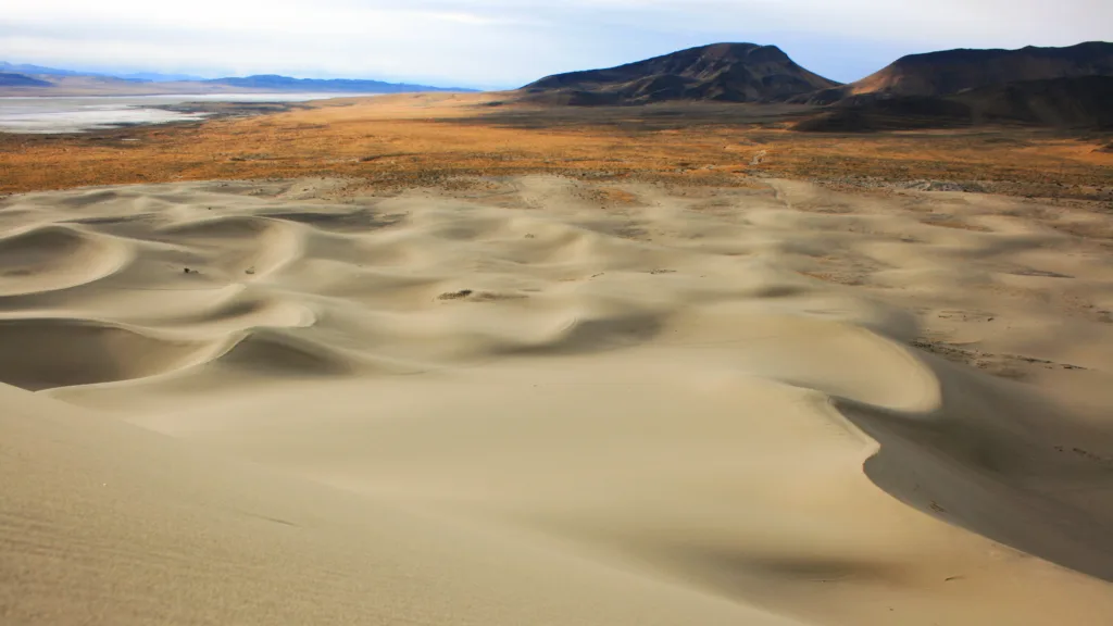
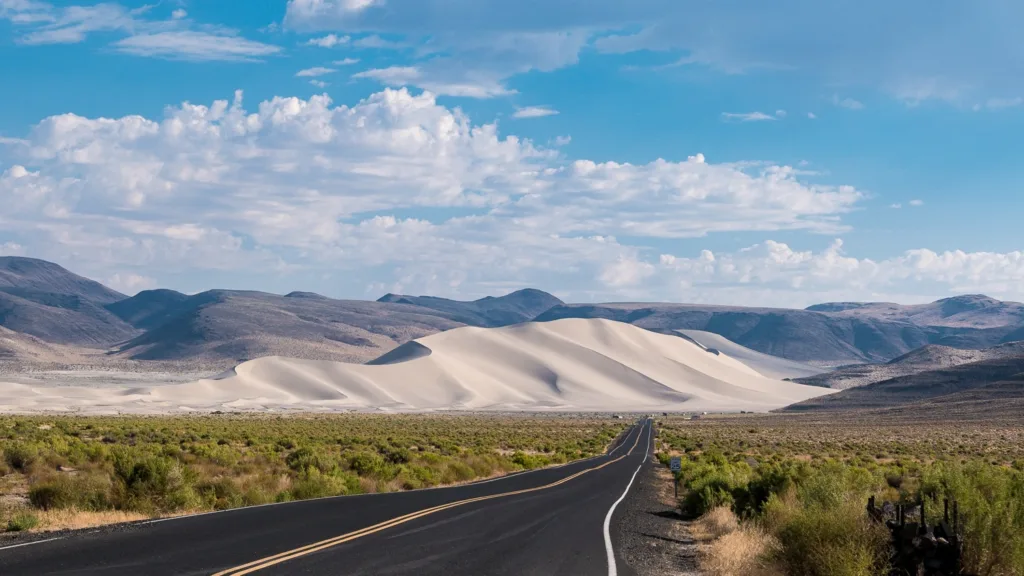
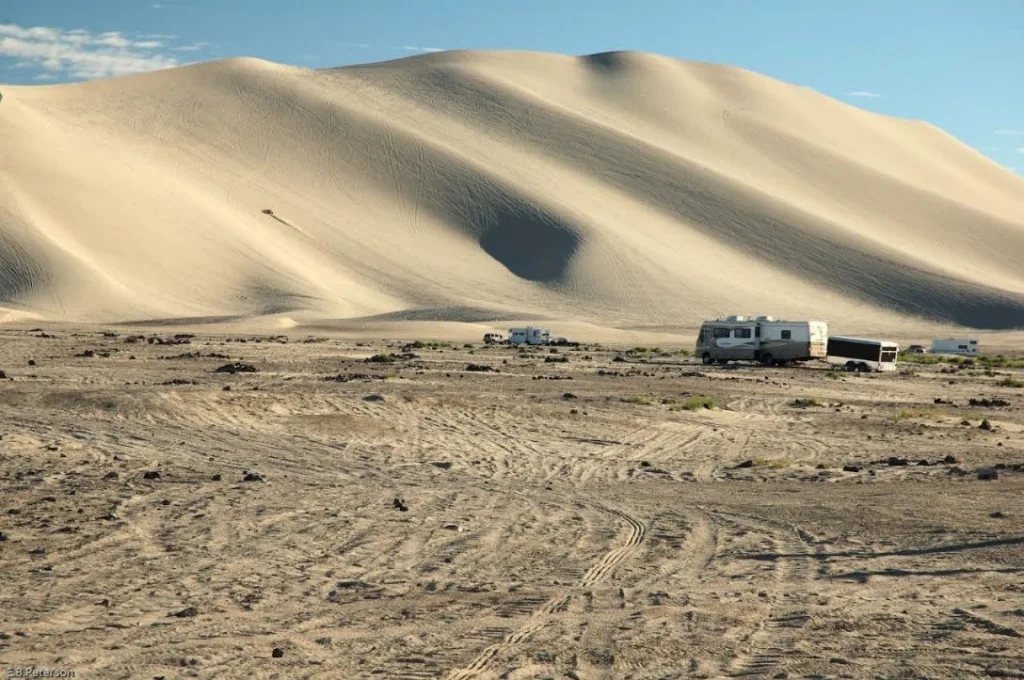
Sand Mountain, located in Nevada, USA, is a fascinating and unique natural landmark known for its immense sand dune. This remarkable destination is part of the Sand Mountain Recreation Area, offering a wide range of outdoor activities and a one-of-a-kind desert experience. Here’s an introduction to Sand Mountain, Nevada, including its location, geography, and an overview of the Sand Mountain Recreation Area:
Location: Sand Mountain is situated in the state of Nevada, within the Great Basin Desert region. It is specifically located in the western part of the state, approximately 25 miles east of the city of Fallon. The nearest major urban center is Reno, which is about 100 miles to the northwest.
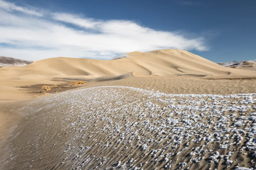
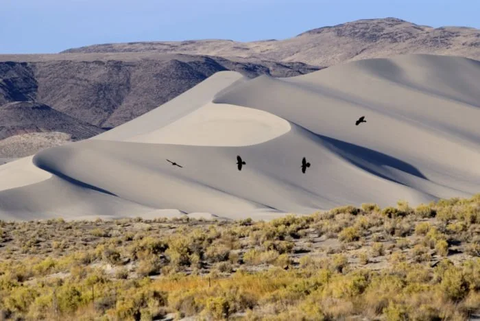
Geography: The centerpiece of Sand Mountain is, of course, the enormous sand dune that stands out amidst the desert landscape. This massive dune rises to a height of approximately 600 feet and stretches over a length of nearly two miles, making it one of the largest dunes in the United States. The dune is composed primarily of fine sand, which is constantly shifting and changing due to wind and weather conditions.
Sand Mountain Recreation Area: The Sand Mountain Recreation Area is managed by the Bureau of Land Management (BLM) and provides a wide range of recreational opportunities for visitors. Here’s an overview of what you can expect at this unique desert destination:
Off-Highway Vehicle (OHV) Riding: Sand Mountain is renowned for its OHV riding opportunities. The dunes offer thrilling terrain for dirt bikes, all-terrain vehicles (ATVs), sand rails, and other off-road vehicles. The area features designated trails and open riding areas to cater to all skill levels.
Camping: The recreation area provides camping facilities for those looking to spend more than a day exploring the dunes. Campsites are equipped with amenities such as picnic tables, fire rings, and vault toilets. Keep in mind that the desert can get extremely hot during the day and quite cold at night, so be prepared for fluctuating temperatures.
Hiking: While the main attraction is the sand dune, there are also opportunities for hiking and exploring the surrounding desert landscape. Visitors can take short hikes to enjoy panoramic views of Sand Mountain and the vast desert expanse.
Photography and Scenic Views: Sand Mountain offers fantastic opportunities for photographers, especially during sunrise and sunset when the dunes take on striking colors and shadows. The contrast between the golden sand and the clear blue skies creates stunning visuals.
Seasonal Events: The Sand Mountain Recreation Area occasionally hosts events, including OHV races and competitions, which attract enthusiasts from across the region.
Visitors to Sand Mountain can expect a truly unique and exhilarating desert experience, whether they are OHV enthusiasts, nature lovers, or simply seeking a serene and otherworldly landscape to explore. It’s essential to follow all BLM regulations and safety guidelines while enjoying this remarkable natural wonder to ensure a safe and enjoyable visit.
Geology and Formation
Geology and Formation of Sand Mountain: Sand Mountain, with its massive sand dune, is a remarkable geological feature shaped by a combination of factors, primarily wind and sand deposition. Here’s a closer look at the geology and formation of Sand Mountain:
Wind Erosion and Deposition: The primary factor in the formation of Sand Mountain is wind. Strong prevailing winds, typical in desert regions, pick up sand particles from the surrounding desert floor and transport them through the air. As the winds lose speed or encounter an obstacle like the Toiyabe Range to the west, they drop the sand particles they carry. Over time, these deposited sand grains accumulate to form a sand dune.
Shifting Sands: The sand dune at Sand Mountain is characterized by its constantly shifting sands. The dune’s appearance changes as wind patterns and weather conditions alter the shape and composition of the sand. This dynamic nature is a key feature of the area and contributes to its unique charm.
How Sand Dunes Form: Sand dunes like the one at Sand Mountain form through a process known as aeolian (wind-driven) activity. Here’s a brief overview of how sand dunes form:
Sand Supply: A source of sand is essential for dune formation. In desert regions, this sand typically comes from dry lakebeds, riverbanks, or eroded rock formations.
Wind Action: Prevailing winds in the area transport sand grains through the air. The wind lifts and carries the sand particles, creating a “saltation” effect where they bounce along the ground.
Deposition: When the wind loses energy or encounters an obstacle like vegetation or terrain features, it drops the sand particles it’s carrying. This leads to the accumulation of sand in specific areas, gradually building up dunes over time.
Dune Migration: Sand dunes are not static; they migrate and change shape as wind patterns shift and redistribute sand. This constant movement is responsible for the unique shapes and sizes of sand dunes.
Unique Features of Sand Mountain: Sand Mountain stands out as a distinctive natural landmark due to several unique features:
Impressive Size: Sand Mountain’s central dune is one of the largest in the United States, rising to a height of approximately 600 feet. Its size and prominence make it a significant attraction for outdoor enthusiasts.
Constantly Shifting Sands: The dune’s dynamic nature means that its appearance is ever-changing. The shifting sands create a mesmerizing and surreal landscape that captivates visitors.
Accessibility: Sand Mountain’s accessibility and designated OHV riding areas make it a popular destination for off-road vehicle enthusiasts.
Geological History: The geological history of Sand Mountain is intimately tied to the region’s broader geological history, which is characterized by arid desert conditions, wind erosion, and the presence of sand-rich environments. While specific details about the dune’s formation timeline may not be readily available, it is part of the ongoing geological processes that shape desert landscapes over millions of years.
The Toiyabe Range to the west of Sand Mountain likely plays a role in blocking prevailing winds, leading to the deposition of sand in this specific location. Over time, as wind patterns and sand availability have shifted, Sand Mountain’s dune has grown and evolved into the impressive natural wonder it is today. Understanding the precise geological history would require in-depth scientific research and analysis of the area’s sedimentary records, which may not be readily available to the public.
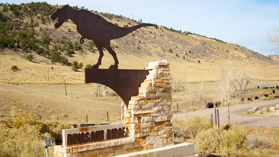
Dinosaur Ridge is a world-renowned paleontological and geological site located near Morrison, Colorado, in the United States. It is a place of great significance in the fields of both paleontology and geology, offering a unique window into Earth’s ancient history.
Location and Geological Context: Dinosaur Ridge is situated in the Morrison Fossil Area National Natural Landmark, which is part of the larger Morrison Formation. The Morrison Formation is a geologic formation that dates back to the Late Jurassic period, approximately 148 to 155 million years ago. This formation is famous for its rich assemblage of fossils and unique rock layers that provide valuable insights into the prehistoric world.
Dinosaur Ridge itself is a long, winding ridge that extends for about two miles along the eastern foothills of the Rocky Mountains, offering stunning views of the surrounding landscape. The ridge is primarily composed of sandstone and mudstone layers, which were deposited in ancient environments ranging from riverbanks and floodplains to lakes and swamps during the Late Jurassic period.
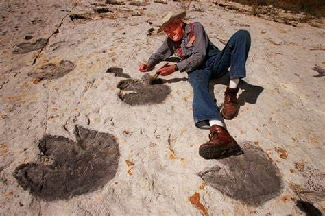
Significance in Paleontology: Dinosaur Ridge is celebrated for its exceptional fossil discoveries, which include a diverse array of dinosaur tracks and fossils from the Late Jurassic era. Some of the key paleontological features and findings at Dinosaur Ridge include:
Dinosaur Tracks: The site is renowned for its well-preserved dinosaur footprints, which provide valuable information about the behavior and locomotion of various dinosaur species. These tracks are found on exposed rock surfaces and include imprints of both herbivorous and carnivorous dinosaurs.
Fossilized Bones: In addition to tracks, numerous dinosaur bones and skeletons have been discovered in the Morrison Formation at Dinosaur Ridge. These fossils have helped scientists understand the types of dinosaurs that lived in the region during the Late Jurassic.
Plant Fossils: Dinosaur Ridge also contains fossilized plants and ancient flora, offering insights into the plant life that coexisted with dinosaurs in this ancient ecosystem.
Significance in Geology: From a geological perspective, Dinosaur Ridge is significant for several reasons:
Stratigraphy: The exposed rock layers at Dinosaur Ridge showcase the stratigraphy of the Morrison Formation, allowing geologists to study the deposition processes and sedimentary history of the region during the Late Jurassic.
Fossilization Processes: The site provides opportunities to study the processes of fossilization, including how tracks and bones became preserved over millions of years.
Educational Value: Dinosaur Ridge serves as an important educational resource, offering visitors a chance to learn about Earth’s geological history and the evolution of life on our planet.
In conclusion, Dinosaur Ridge is a remarkable site that combines paleontological and geological significance. It allows scientists and enthusiasts alike to explore the ancient world of dinosaurs and gain a deeper understanding of the Earth’s geological past during the Late Jurassic period. Moreover, it continues to inspire curiosity and scientific research, making it a cherished location in the study of Earth’s history.
Geological Features
Two of the prominent geological features are the Dakota Hogback and the Morrison Formation.
1. Dakota Hogback: The Dakota Hogback is a distinctive geological feature that extends for miles along the eastern foothills of the Rocky Mountains. It is a prominent ridge made up of tilted and eroded layers of sedimentary rock. Here’s an explanation of its unique characteristics:
Formation: The Dakota Hogback was formed during the Late Cretaceous period, around 100 million years ago. During this time, the area was covered by a shallow sea, and layers of sandstone, shale, and limestone were deposited over millions of years.
Tilted Layers: What sets the Dakota Hogback apart is the steep angle at which these sedimentary layers are tilted. This tilting occurred due to geological forces, such as tectonic activity and uplift, which caused the once-horizontal rock layers to be pushed up at an angle.
Erosion: Over millions of years, erosion by wind, water, and ice has exposed these tilted layers, creating the distinctive hogback ridge that we see today. The erosion-resistant sandstone layers form the prominent ridges, while the softer shale layers erode more easily, creating valleys and slopes.
Fossils: While the Dakota Hogback itself is not known for its fossil finds, the rock layers within it can contain fossils, particularly in the shale and limestone layers. These fossils can provide valuable information about the ancient marine life that once inhabited the region.
2. Morrison Formation: The Morrison Formation is a well-known geological formation that underlies much of the western United States and is of great significance to paleontology. Here’s a description of the Morrison Formation as it pertains to Dinosaur Ridge:
Composition: The Morrison Formation is composed primarily of sedimentary rocks, including sandstone, mudstone, limestone, and conglomerates. These rocks were deposited during the Late Jurassic period, approximately 148 to 155 million years ago.
Ancient Environment: The Morrison Formation was deposited in a variety of environments, including riverbanks, floodplains, lakes, and swamps. This diverse range of environments is reflected in the different rock types and fossils found within the formation.
Fossils: One of the most significant aspects of the Morrison Formation is its rich fossil record. It contains a wide variety of dinosaur fossils, including both herbivorous and carnivorous species. Some well-known dinosaurs from the Morrison Formation include Allosaurus, Stegosaurus, and Apatosaurus (formerly known as Brontosaurus).
Dinosaur Ridge: Dinosaur Ridge is a specific location where the Morrison Formation is exposed, and it has yielded numerous dinosaur tracks and fossils. The site is particularly famous for its dinosaur tracks, which offer valuable insights into the behavior and locomotion of these ancient creatures.
In summary, the Dakota Hogback and the Morrison Formation are key geological features of Dinosaur Ridge. The Dakota Hogback is a striking ridge with tilted sedimentary layers, while the Morrison Formation is a fossil-rich geological unit that preserves the remains of dinosaurs from the Late Jurassic period. Together, these features make Dinosaur Ridge a unique and significant site for both geologists and paleontologists.
Death Valley is a remarkable and extreme geographical feature located in the western United States. It is situated primarily within the state of California, with a small portion extending into Nevada. This iconic desert valley is part of the larger Mojave Desert, and it holds the distinction of being the hottest, driest, and lowest national park in the United States. The valley stretches approximately 140 miles (225 kilometers) in length, with a width ranging from 5 to 15 miles (8 to 24 kilometers).
Geological Significance: Death Valley’s geological significance is rooted in its unique and extreme features, making it a captivating area for geologists and scientists. Here are some key geological aspects of Death Valley:
Lowest Elevation: Death Valley’s Badwater Basin is the lowest point in North America, with an elevation of about 282 feet (86 meters) below sea level. This extreme depth is a result of the complex geological forces at play in the region.
Tectonic Activity: The valley’s formation is closely tied to tectonic activity. Death Valley is part of the Basin and Range Province, where the Earth’s crust is being stretched and pulled apart. The valley itself is formed by a series of fault systems, including the well-known Death Valley Fault, which runs through the area.
Extreme Temperatures: The valley’s reputation for extreme heat is a result of its topography and climatic conditions. It holds the record for the highest reliably recorded air temperature on Earth, reaching 134°F (56.7°C) in 1913 at Furnace Creek Ranch. The valley’s depth and surrounding mountain ranges trap heat, creating these blistering temperatures.
Salt Flats: Death Valley is known for its expansive salt flats, such as those found in Badwater Basin. These salt flats form due to the evaporation of water in the region’s intermittent streams and creeks, leaving behind salt deposits.
Colorful Geology: The valley’s diverse geology includes colorful rock formations, canyons, alluvial fans, and volcanic features. Artist’s Palette, for example, is an area known for its strikingly colorful rocks resulting from mineral deposits.
Uplift and Erosion: The Panamint Range to the west of Death Valley is characterized by dramatic uplift, while the valley itself experiences erosion. This dynamic interaction between uplift and erosion continues to shape the region’s landscape.
Playa Features: Playas are dry lakebeds that form in the valley, such as Racetrack Playa. These playas often feature unique geological phenomena, including the mysterious “sailing stones” that leave trails on the playa’s surface.
In summary, Death Valley’s geological significance lies in its extreme features, including its low elevation, tectonic activity, salt flats, colorful geology, and the interaction between uplift and erosion. This remarkable landscape continues to be a valuable area for geological research and exploration.
Formation of Death Valley
The formation of Death Valley is a complex geological process that spans millions of years and involves a combination of tectonic activity, erosion, and climatic changes. Here’s an overview of the key factors that contributed to the formation of Death Valley:
Tectonic Activity:
Death Valley is situated within the Basin and Range Province, a region of the western United States characterized by elongated mountain ranges separated by down-dropped valleys, or basins.
The primary geological feature responsible for Death Valley’s formation is the stretching and pulling apart of the Earth’s crust due to tectonic forces. This process is known as extensional tectonics.
Extensional tectonics in the Basin and Range Province have created numerous normal faults, including the prominent Death Valley Fault system that runs through the area.
The valley itself is essentially a large block of the Earth’s crust that has dropped down between these fault lines, forming a low-lying basin.
Mountain Uplift:
To the west of Death Valley, the Panamint Range and other mountain ranges have experienced uplift due to tectonic forces. These mountains have been gradually rising over millions of years.
The uplift of the surrounding mountain ranges contributes to the steep relief and elevation differences between the mountains and the valley floor.
Erosion:
Over time, the combined effects of wind, water, and weathering have eroded the mountains surrounding Death Valley.
Sediments and rocks from the mountains have been transported into the valley by rivers and streams, filling in the basin and contributing to the accumulation of alluvial fans.
The erosional processes have exposed colorful geological formations and created deep canyons within the valley, adding to its unique landscape.
Climate and Lake Cycles:
The climate in Death Valley has undergone significant changes over geological time scales. At times, it was wetter and cooler, allowing for the presence of lakes.
Ancient lakes, such as Lake Manly, once covered large portions of the valley floor during wetter periods. These lakes left behind deposits of salt and sediment, contributing to the salt flats found in places like Badwater Basin.
Playa Formation:
Playas, or dry lakebeds, are a characteristic feature of Death Valley. They form as a result of the evaporation of water in intermittent streams and creeks that flow into the valley.
The accumulation of salts and minerals in the playas, due to the evaporation process, has created expansive salt flats.
Modern Climate:
Today, Death Valley experiences an extremely hot and arid climate, with minimal rainfall and high temperatures during the summer months. These harsh conditions are a result of its low elevation and geographical features.
In summary, Death Valley’s formation is the result of a combination of tectonic activity, mountain uplift, erosion, climatic changes, and the interplay of geological forces over millions of years. This complex geological history has created the unique and extreme landscape that characterizes Death Valley today.
Topographical Features
Death Valley is known for its diverse and striking topographical features, which contribute to its unique and dramatic landscape. Here are some of the most prominent topographical features in Death Valley:
Salt Flats
Salt Flats:
The salt flats, particularly in areas like Badwater Basin, are among the most iconic features of Death Valley. These expansive, white salt flats are the result of the evaporation of water in the region’s intermittent streams and creeks, leaving behind salt deposits. They create a surreal and otherworldly appearance.
Badwater Basin
Badwater Basin:
Badwater Basin is the lowest point in North America, with an elevation of about 282 feet (86 meters) below sea level. It is a vast salt flat that stretches for miles and is surrounded by the Black Mountains. The salt crust can be so thick that it often forms hexagonal shapes.
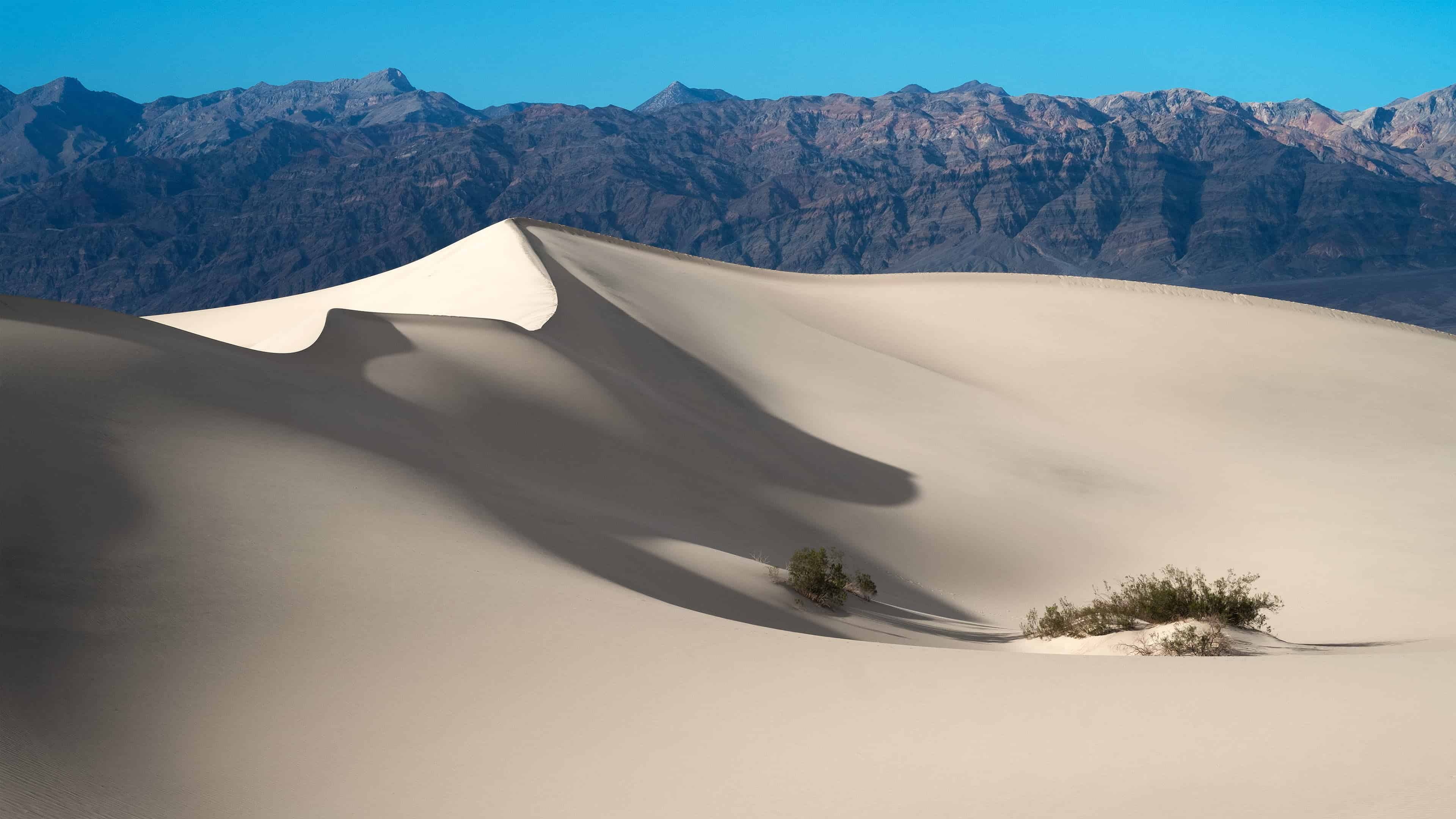
Mesquite Flat Sand Dunes
Mesquite Flat Sand Dunes
These picturesque sand dunes, located in the Mesquite Flat area of Death Valley, are some of the most well-known sand dunes in the United States. They offer a classic desert landscape, with towering dunes that can reach up to 100 feet (30 meters) in height.
Artist’s Palette
Artist’s Palette
Artist’s Palette is an area known for its colorful geology. The rocks here exhibit a stunning array of colors, including reds, pinks, purples, and greens. These hues are a result of various mineral deposits and oxidation processes.
Ubehebe Crater
Ubehebe Crater
Ubehebe Crater is a large volcanic crater located in the northern part of Death Valley. It was formed by a massive volcanic explosion thousands of years ago. The crater is approximately 600 feet (183 meters) deep and half a mile (0.8 kilometers) wide, making it an impressive geological feature.
Zabriskie Point
Zabriskie Point
Zabriskie Point offers one of the most iconic vistas in Death Valley. It provides panoramic views of the badlands, which are characterized by eroded and colorful clay hills. The erosional processes have created a unique, labyrinthine landscape.
Canyons
Canyons:
Death Valley is home to numerous canyons, such as Golden Canyon and Mosaic Canyon. These canyons feature narrow, winding passages with steep, towering walls. Golden Canyon, in particular, is famous for its red rock formations and hiking trails.
sailing stones
Playas:
Playas are dry lakebeds found in the valley, including Racetrack Playa, where the mysterious “sailing stones” leave tracks on the surface. These flat, dry areas contrast with the rugged terrain of the surrounding mountains.
Alluvial Fans
Alluvial Fans:
The valley is dotted with alluvial fans, which are cone-shaped deposits of sediment and debris that have been carried down from the mountains by water erosion. These fans are often fan-shaped and contribute to the overall topography of the valley.
Mountain Ranges:
Surrounding Death Valley are several mountain ranges, including the Panamint Range to the west. These mountains add to the dramatic contrast between high peaks and low valleys, contributing to the valley’s unique topography.
These topographical features, combined with the extreme climate and geological history, make Death Valley a fascinating and visually stunning destination for travelers and researchers alike.
Salt Flats and Playas
Salt flats and playas are distinct but related topographical features commonly found in arid regions like deserts, including Death Valley. While they share some similarities, they also have distinct characteristics:
Salt Flats:
Formation: Salt flats, also known as salt pans, form when water from streams, rivers, or underground springs evaporates in an arid environment, leaving behind concentrated salt deposits. These deposits can accumulate over time, resulting in expansive areas covered with a layer of salt.
Appearance: Salt flats are typically flat, white, and barren, often resembling a vast expanse of cracked and desiccated ground. The crust of salt can be quite thick and can take on hexagonal shapes as it dries and cracks.
Composition: The primary component of salt flats is salt, primarily sodium chloride (table salt). However, other minerals and salts can also be present, giving rise to variations in color and texture.
Death Valley Example: Badwater Basin in Death Valley is a famous salt flat known for its stark white salt crust. The flats here stretch for miles and are one of the lowest points in North America.
Playas:
Formation: Playas are dry lakebeds that form when water occasionally collects in low-lying areas, typically during heavy rains or flash floods. As the water evaporates or drains away, it leaves behind a flat, sometimes cracked surface.
Appearance: Playas can have a flat or gently undulating surface and may be covered in fine silt, clay, or salt deposits, depending on the local geology and water source. They often have a light-colored appearance.
Composition: Playas can contain various minerals, including salts, clays, and sediments, depending on the sources of water and the region’s geological makeup. The composition may vary from one playa to another.
Death Valley Example: Racetrack Playa in Death Valley is a well-known playa famous for its mysterious “sailing stones.” These stones appear to move across the playa surface, leaving behind long trails, and their movement remains a subject of scientific investigation.
In summary, salt flats are primarily composed of salt deposits resulting from the evaporation of saline water, while playas are dry lakebeds that temporarily collect water during rain events and may have a more diverse composition. Both salt flats and playas contribute to the unique and striking landscape of arid regions like Death Valley.
Canyons and Gorges
Golden Canyon
Canyons and gorges are natural geological formations characterized by deep, narrow valleys or ravines carved out by various geological processes. They often feature unique geological features and are shaped by erosional forces such as water, wind, and ice. Let’s take a look at the formation and geological features of two canyons in Death Valley: Golden Canyon and Mosaic Canyon.
Formation of Canyons: Canyons like Golden Canyon and Mosaic Canyon are typically formed through a combination of geological processes, including erosion and tectonic activity. Here’s how they are formed:
Erosion: The primary agent of canyon formation is erosion, which can be driven by various factors:
Water Erosion: Rivers and streams can cut through rock layers over time, deepening and widening the valleys as they flow downhill. Flash floods can also have a significant erosional impact in arid regions like Death Valley.
Wind Erosion: Wind-blown sand and sediment can slowly wear away rock surfaces, creating narrow channels and sculpting the canyon walls.
Freeze-Thaw Cycles: In colder climates, the expansion of ice in cracks and crevices can exert pressure on rock, gradually breaking it apart.
Tectonic Activity: Tectonic forces, such as the uplifting of mountain ranges or the creation of fault lines, can contribute to the initial formation of valleys. The subsequent erosional processes then shape these valleys into canyons.
Golden Canyon: Golden Canyon is one of the well-known canyons in Death Valley, and it has several distinctive geological features:
Formation: Golden Canyon was primarily formed by water erosion from periodic flash floods. Over time, these floods carved out the narrow, winding path that characterizes the canyon today.
Geological Features: Within Golden Canyon, you can find:
Vibrant Colors: The canyon walls are rich in various minerals, giving rise to a palette of colors, including gold, red, and green, depending on the mineral content and oxidation state.
Narrow Passages: The canyon narrows in some sections, creating tight, towering walls that provide dramatic views for hikers.
Hiking Trails: Golden Canyon is a popular hiking destination, and trails lead deeper into the canyon, offering the chance to explore its geological features up close.
Mosaic Canyon
Mosaic Canyon: Mosaic Canyon is another fascinating canyon in Death Valley, known for its distinct geological characteristics:
Formation: Mosaic Canyon was carved by water erosion, but it also features dramatic narrows that are the result of faulting and fracturing in the rock layers. The narrower sections of the canyon are particularly stunning.
Geological Features: Within Mosaic Canyon, you can encounter:
Smooth Marble Walls: The canyon is famous for its polished, smooth marble walls, which have been sculpted by water flowing through the canyon.
Narrows: Mosaic Canyon’s narrows are particularly noteworthy, with walls that can be incredibly narrow in some places, creating a sense of enclosure and wonder for hikers.
Dry Falls and Ephemeral Pools: Depending on the season and recent rainfall, hikers might come across dry waterfalls and ephemeral pools within the canyon.
In both Golden Canyon and Mosaic Canyon, the combination of erosion and geological processes has created unique and visually captivating landscapes, making them popular destinations for hikers and geology enthusiasts in Death Valley.
Minerals and Precious Metals
Death Valley has a rich history of mineral deposits and mining activities, with the region being known for its diverse range of minerals and occasional precious metal discoveries. Here’s an overview of mineral deposits and historical mining activities in Death Valley:
Mineral Deposits in Death Valley:
Borax: One of the most famous minerals associated with Death Valley is borax, a mineral used in various industrial applications, including cleaning and as a fire retardant. The vast deposits of borax in the Furnace Creek area of Death Valley led to the establishment of the Pacific Coast Borax Company, which later became known as the Twenty Mule Team Borax.
Salt: Salt flats, like those found in Badwater Basin, are rich sources of salt deposits. The valley’s extreme arid conditions, with occasional water flows, have contributed to the accumulation of salt in these areas.
Talc: Talc, a soft mineral used in cosmetics and other products, can be found in some parts of Death Valley. Talc deposits are often associated with metamorphic rocks.
Gold and Silver: While not as abundant as in some other mining regions, Death Valley has seen periods of gold and silver mining activity. These precious metals were often found in quartz veins and associated with other minerals.
Copper and Lead-Zinc: Copper and lead-zinc deposits have also been discovered in some parts of Death Valley, although mining for these metals was relatively limited compared to other regions.
Historical Mining Activities:
Borax Mining: The discovery of borax in the Furnace Creek area of Death Valley in the late 19th century led to significant mining operations. The Pacific Coast Borax Company operated large-scale borax mining operations using the famous “Twenty Mule Teams” to transport the borax to processing facilities.
Gold and Silver Rushes: Death Valley experienced several gold and silver rushes during the late 19th and early 20th centuries. Rhyolite, a nearby mining town, boomed in response to gold discoveries in the surrounding area. However, these rushes were often short-lived and didn’t lead to long-term mining prosperity.
Lead and Zinc Mining: The Panamint Mountains in Death Valley contained lead-zinc deposits, and mining activities took place during the early 20th century. However, the isolation of the area and the challenges of extracting these metals contributed to the eventual decline of mining operations.
Abandoned Mining Ghost Towns: Numerous mining camps and towns, such as Skidoo and Ballarat, were established in Death Valley during the mining booms. Today, many of these settlements are abandoned ghost towns, serving as historical relics of the region’s mining heritage.
Modern Mining: While large-scale mining activities have largely ceased in Death Valley, there are still some claims and small-scale mining operations in the area. These activities are subject to environmental regulations and are typically less extensive than historical mining operations.
It’s important to note that Death Valley’s harsh climate and remote location presented significant challenges to miners, making mining in the region a challenging endeavor. Additionally, the conservation and preservation of the natural and cultural heritage of Death Valley National Park have placed restrictions on new mining activities within the park boundaries.
Volcanic Features
Death Valley National Park, despite being known for its extreme arid conditions and desert landscapes, also contains several significant volcanic features that provide insight into the region’s geological history. Here’s an overview of the volcanic history and some notable volcanic formations in Death Valley:
Volcanic History:
Tectonic Setting: Death Valley’s volcanic features are primarily the result of its tectonic setting. The valley is located within the Basin and Range Province, where the Earth’s crust is being stretched and pulled apart, leading to the formation of numerous fault systems and volcanic activity.
Volcanic Periods: The volcanic history of Death Valley spans millions of years, with eruptions occurring intermittently over time. The volcanic activity has produced a variety of volcanic landforms and deposits.
Notable Volcanic Formations:
Ubehebe Crater: Ubehebe Crater is one of the most prominent and well-known volcanic features in Death Valley. It is a large volcanic crater located in the northern part of the park. Some key details about Ubehebe Crater include:
Formation: Ubehebe Crater was formed through a massive volcanic explosion thousands of years ago. The explosion was caused by the interaction between hot magma and groundwater, leading to a sudden release of pressure.
Size: The crater is approximately 600 feet (183 meters) deep and half a mile (0.8 kilometers) wide, making it an impressive geological feature.
Hiking: Visitors can hike to the rim of Ubehebe Crater and explore the surrounding area, providing a unique perspective on volcanic geology.
Little Hebe Crater: Located near Ubehebe Crater, Little Hebe Crater is a smaller volcanic crater. It is believed to have formed as a result of a separate volcanic eruption event.
Volcanic Flows and Cinder Cones: Throughout Death Valley, you can find evidence of ancient volcanic flows and cinder cones. These formations result from the eruption of magma, which can create lava flows that spread across the landscape. Cinder cones are often associated with explosive volcanic eruptions and can be seen in various parts of the park.
Black Mountains and Funeral Mountains: These mountain ranges in Death Valley are primarily composed of volcanic rocks, including basalt and andesite. The Black Mountains are known for their dark-colored volcanic rock, contrasting with the surrounding desert landscape.
Ash Meadows: While not within Death Valley National Park itself, Ash Meadows National Wildlife Refuge, located to the east of the park, contains remnants of ancient volcanic activity. The refuge features spring-fed wetlands, which are connected to groundwater influenced by volcanic ash deposits.
Overall, Death Valley’s volcanic history and formations provide a glimpse into the dynamic geological processes that have shaped the region over millions of years. These features, including Ubehebe Crater and various lava flows, add to the diversity of landscapes and geological wonders that can be explored in the park.
Tourism and Visitor Experience
Tourism in Death Valley National Park offers visitors a chance to experience a unique and diverse natural environment, complete with extreme landscapes, geologic wonders, and opportunities for outdoor recreation. Here’s an overview of the tourism and visitor experience in Death Valley:
Visitor Centers and Information:
Death Valley National Park has multiple visitor centers, including the Furnace Creek Visitor Center, Stovepipe Wells Ranger Station, and others. These centers provide maps, brochures, exhibits, and knowledgeable park rangers who can offer guidance and information about the park’s geology, history, and recreational opportunities.
Scenic Drives:
Death Valley offers several stunning scenic drives that allow visitors to explore the park’s diverse landscapes from the comfort of their vehicles. Notable routes include Badwater Road, Artist’s Drive, and the road to Dante’s View, which offers panoramic vistas.
Hiking and Backpacking:
The park boasts a variety of hiking trails suitable for all levels of hikers. Popular trails include Golden Canyon, Mosaic Canyon, and the Mesquite Flat Sand Dunes. Backpackers can explore more remote areas, but they should be prepared for extreme conditions, including high temperatures and limited water sources.
Camping:
Death Valley National Park has numerous campgrounds, both developed and primitive. Campgrounds like Furnace Creek, Mesquite Spring, and Wildrose Campground offer a range of amenities. Backcountry camping is also permitted in designated areas with a free permit.
Stargazing:
Death Valley is designated as a Dark Sky Park, making it an excellent location for stargazing. The clear desert skies provide an opportunity to view stars, planets, and celestial phenomena. Special stargazing programs are often organized by the park service.
Photography:
The park’s unique landscapes and geological formations make it a paradise for photographers. Sunrise and sunset are particularly photogenic times to capture the interplay of light and shadows on the desert terrain.
Wildlife Watching:
While the park’s harsh environment may not seem conducive to wildlife, Death Valley is home to a surprising variety of animals, including desert bighorn sheep, coyotes, and numerous bird species. Observing wildlife in their natural habitat is a rewarding experience for visitors.
Interpretive Programs:
Ranger-led programs, talks, and guided hikes are often offered during the cooler months. These programs provide educational insights into the park’s geology, ecology, and cultural history.
Safety Precautions:
Visitors should be aware of the extreme climate in Death Valley. Summers can be unbearably hot, with temperatures exceeding 120°F (49°C). It’s essential to stay hydrated, protect yourself from the sun, and be prepared for emergencies.
Flash floods can occur during rain events, so it’s crucial to be cautious when exploring canyons and washes, especially during thunderstorms.
Respect for the Environment:
Visitors are encouraged to follow Leave No Trace principles, respecting the fragile desert ecosystem. This includes packing out all trash, staying on designated trails, and not disturbing wildlife.
Visiting Death Valley National Park offers a chance to connect with nature, explore unique geological features, and gain a deeper appreciation for the resilience of life in extreme environments. It’s important to plan your visit carefully, especially considering the weather and the time of year, to ensure a safe and enjoyable experience.
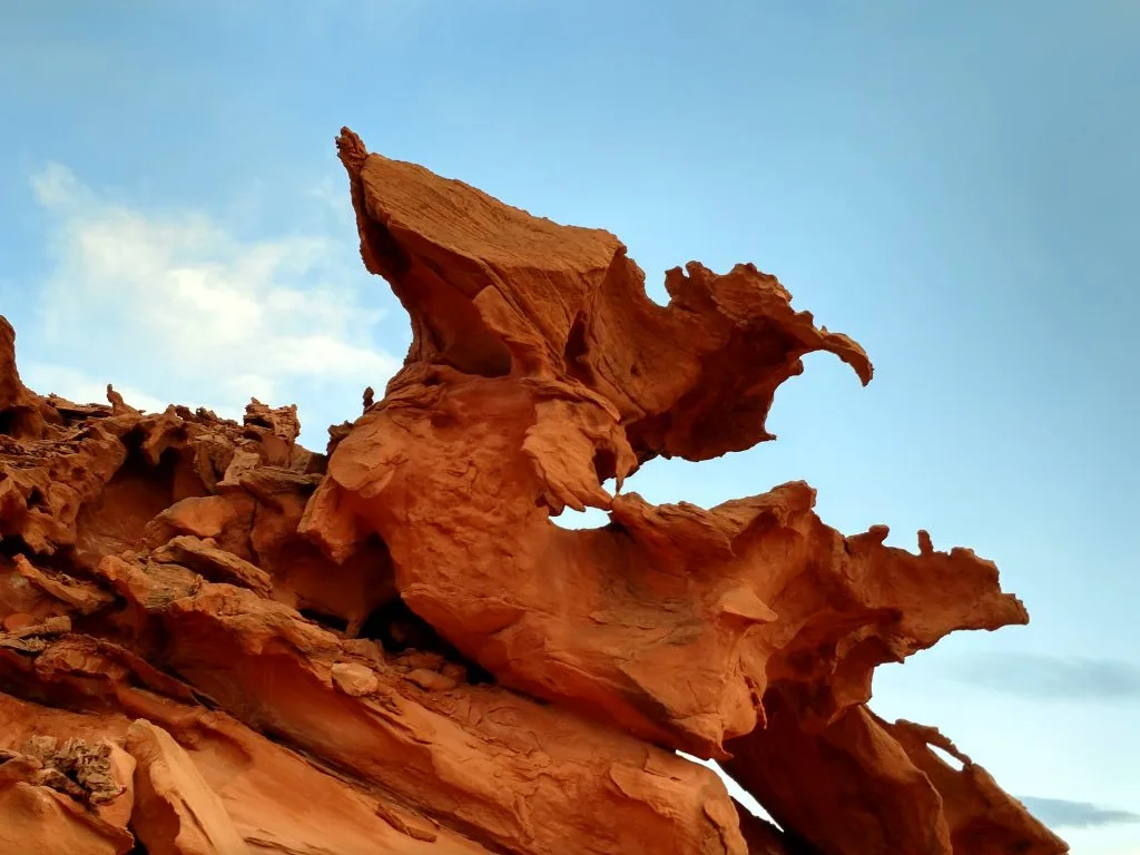
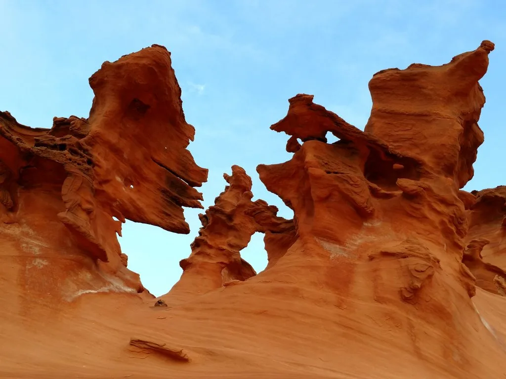
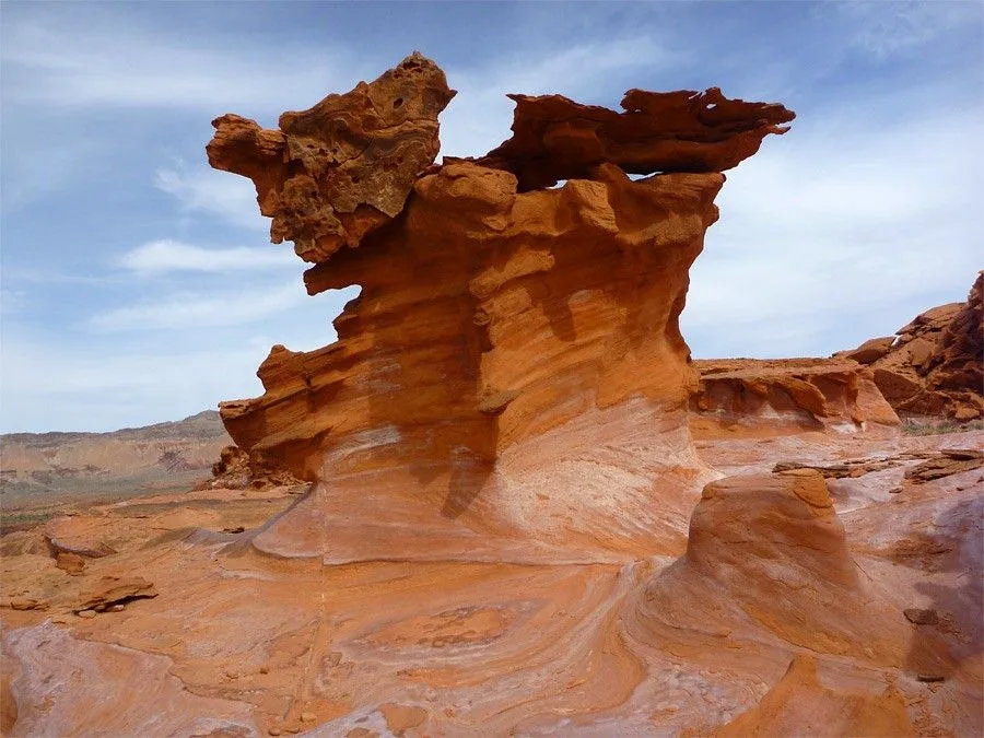
Nestled deep within the heart of the Mojave Desert in Southern Nevada, Little Finland stands as a testament to the awe-inspiring forces of nature. This remote and enigmatic landscape, also known as “Hobgoblin’s Playground” and “Devil’s Fire,” boasts a surreal collection of sandstone formations that appear as if they were sculpted by the whims of cosmic artistry.
Little Finland, Nevada
Little Finland’s significance lies in its extraordinary geology and unique aesthetic appeal. Carved by wind and water over countless millennia, the twisted and contorted rock formations of this natural wonderland stand as a testament to the Earth’s unparalleled capacity for crafting the surreal. To behold the sculpted wonders of Little Finland is to be transported to a realm that defies conventional understanding, where nature’s creative forces have conjured a landscape that appears plucked from the dreams of science fiction.
As we journey deeper into this extraordinary place, we will uncover the secrets of its geologic marvels, and explore the sense of wonder and adventure that draws explorers and photographers from around the world to this remote and magical corner of Nevada.
Geological Formation
The mesmerizing sandstone formations of Little Finland owe their existence to a complex interplay of geological processes that unfolded over millions of years. Here’s a breakdown of how these unique sandstone formations were created:
1. Sedimentary Processes: Little Finland’s sandstone formations are primarily sedimentary rocks, which means they originated from the accumulation and compaction of sediment over time. The process begins with the erosion of pre-existing rock material, which is then transported by natural agents such as water, wind, or ice. In the case of Little Finland, wind and water played significant roles in transporting and depositing sand.
2. Deposition: As wind or water transports sand and other sediments, they eventually settle in areas with reduced energy, such as riverbeds, lakeshores, or deserts. Over time, the sediments accumulate layer by layer.
3. Compaction and Cementation: As more sediment accumulates, the weight of overlying layers compresses the lower layers. This compression, along with the presence of minerals like silica, calcium carbonate, or iron oxide, leads to cementation. Cementation is the process by which sediments harden into rock, binding the grains together.
4. Cross-Bedding Patterns: One of the distinctive features of the sandstone formations in Little Finland is their cross-bedding patterns. Cross-bedding occurs when layers of sediment within a larger sedimentary unit are inclined relative to the main horizontal layer. These inclined layers are known as cross-beds. Cross-bedding is often the result of shifting currents or wind directions during deposition.
5. Significance of Cross-Bedding: Cross-bedding patterns in sandstone formations provide valuable clues about the ancient environmental conditions in which the rocks formed. For example, in the case of Little Finland, the cross-bedding patterns suggest that these sandstone formations were likely created in a desert environment with shifting wind patterns. The dune-like structures and inclined layers point to the dynamic nature of the ancient desert landscape.
6. Geological Time Scale and Era: The sandstone formations in Little Finland belong to the Jurassic Period, which occurred approximately 201 to 145 million years ago. During this era, the area that is now the Mojave Desert was covered by vast sand dunes. Over time, the layers of sand deposited in this desert environment underwent compaction and cementation, eventually forming the unique sandstone structures we see today.
In summary, Little Finland’s sandstone formations are a testament to the enduring power of sedimentary processes and the dynamic history of Earth’s landscapes. These remarkable geological features offer a window into the distant past, providing insight into the environmental conditions and processes that shaped this surreal and captivating desert wonderland.
Unique Features
Little Finland is a geological wonderland that boasts a myriad of distinctive and surreal rock formations, each with its own unique character and charm. Here’s a description of some of the notable rock shapes and names that make this place so extraordinary:
Hobgoblin’s Playground: Perhaps the most famous formation in Little Finland, Hobgoblin’s Playground is a mesmerizing collection of whimsical sandstone shapes. Here, you’ll find towering spires, twisted columns, and arches that seem to defy gravity. The rocks’ reddish hues and peculiar, contorted forms make it feel as if you’ve stepped into a fantasy realm.
Devil’s Fire: This formation is known for its fiery and jagged appearance. It features towering rock fins and spires that, when illuminated by the warm glow of the setting sun, seem to flicker like flames. The fiery, almost infernal aesthetic of Devil’s Fire adds to the mystical aura of Little Finland.
The Flying Saucer: Resembling a UFO perched on a landing pad, the Flying Saucer is a flat, circular rock with a raised center, almost like a giant pancake. This curious shape adds an element of the extraterrestrial to the landscape, fitting with the surreal ambiance of the area.
The Wave: While not to be confused with the famous “Wave” formation in Arizona, Little Finland has its own smaller-scale wave-like structures. These undulating sandstone formations create a sense of fluidity and motion within the otherwise rugged landscape.
The Totem Pole: Standing tall and slender, the Totem Pole is a narrow rock spire that appears almost man-made in its precision. It provides a striking contrast to the more chaotic and organic shapes found in other parts of Little Finland.
The Alien Throne: As the name suggests, this formation resembles a peculiar, throne-like seat carved out of the sandstone. It’s an ideal spot for visitors to take a seat and contemplate the alien beauty of the landscape.
The unique features of Little Finland are of paramount importance for geotourism. Geotourism, a form of sustainable tourism that focuses on the Earth’s geological features, provides an opportunity for visitors to appreciate the natural beauty and geological history of the region. Little Finland’s surreal and one-of-a-kind rock formations make it a magnet for geotourists, photographers, and nature enthusiasts from around the world. It offers a chance to witness the intricate artistry of geological processes and gain a deeper understanding of the Earth’s dynamic history. Moreover, the otherworldly appearance of these formations adds an element of adventure and discovery, making it a truly unforgettable destination for those seeking to connect with the planet’s geological wonders.
Visitor Experience
The visitor experience at Little Finland is nothing short of extraordinary. As you journey into this remote and otherworldly landscape, you’ll find yourself immersed in a surreal and captivating environment. Here’s a glimpse of what to expect when you visit Little Finland:
Awe-Inspiring Scenery: The moment you set foot in Little Finland, you’ll be greeted by a surreal and almost alien landscape. The contorted sandstone formations, with their rich red and orange hues, create a visual spectacle that is both breathtaking and mesmerizing. It’s a photographer’s dream, with countless opportunities for capturing the unique beauty of the desert.
Hiking and Exploration: Little Finland offers a variety of hiking trails and opportunities for exploration. While the area is not heavily marked with trails, this adds to the sense of adventure and discovery. Visitors can wander among the rock formations, climb on the sandstone sculptures, and traverse the undulating terrain. Just be sure to take precautions, bring plenty of water, and respect the fragile environment.
Photography: Little Finland is a paradise for photographers. The interplay of light and shadow on the contoured rocks creates a dynamic and ever-changing canvas for your camera. Sunrise and sunset are particularly magical times to capture the formations in their most dramatic and enchanting light.
Stargazing: Being far from urban light pollution, Little Finland offers an excellent opportunity for stargazing. The desert skies are often clear, allowing you to witness a breathtaking night sky filled with stars, planets, and celestial wonders.
Serene Isolation: One of the unique aspects of Little Finland is its remote and isolated location. It’s a place where you can escape the hustle and bustle of modern life, disconnect from technology, and find solace in the tranquil desert surroundings. The sense of solitude and quietude is a profound part of the experience.
Leave No Trace: Little Finland is a fragile environment, and it’s essential to practice responsible and sustainable tourism. Leave no trace by packing out all trash, avoiding unnecessary disturbances to the terrain, and respecting any guidelines or restrictions in place to protect the area.
Safety Considerations: Little Finland’s isolation means that you should come well-prepared. It’s wise to inform someone of your plans, carry essential supplies (water, food, first aid), and be aware of the weather conditions, as desert temperatures can be extreme.
In conclusion, a visit to Little Finland offers an unforgettable and almost surreal experience. It’s a place where you can immerse yourself in the wonders of nature, connect with the Earth’s geological history, and find inspiration in the beauty of this extraordinary desert landscape. Whether you’re a hiker, photographer, or simply seeking a profound connection with the natural world, Little Finland promises an adventure that will leave you in awe of the planet’s incredible diversity and creativity.
Willemite is a mineral with the chemical formula Zn2SiO4. It is a zinc silicate and is known for its unique fluorescence properties, making it a fascinating material both in the field of mineralogy and as a fluorescent collector’s gem. In this introduction, we’ll explore its definition, crystal structure, and historical background.
Willemite is a rare mineral that consists of zinc, silicon, and oxygen atoms arranged in a specific crystal structure. Its chemical formula is Zn2SiO4, which means that for every two atoms of zinc, there is one atom of silicon and four atoms of oxygen bonded together in a structured lattice.
Crystal Structure: Willemite belongs to the hexagonal crystal system. Its crystal structure is typically classified as hexagonal prismatic, and it forms hexagonal prismatic crystals. The atoms in the crystal lattice are arranged in a way that gives willemite its unique optical properties, including its fluorescence when exposed to ultraviolet (UV) light.
Historical Background and Discovery: Willemite was first discovered in 1830 in the Roughton Gill Mine in Caldbeck Fells, Cumbria, England. It was named after William I of the Netherlands, who was king at the time of its discovery. The mineral gained popularity among mineral collectors for its striking green fluorescence under UV light.
The fluorescence of willemite is a result of trace impurities within the crystal lattice, particularly small amounts of manganese. When these impurities are exposed to UV light, they emit visible light, creating the distinctive green glow that willemite is known for. This property made willemite a sought-after collector’s item, and specimens with intense fluorescence are highly prized.
In addition to its fluorescent properties, willemite is also found in a range of colors, including green, yellow, brown, and rarely, colorless. It can occur in various geological settings, often associated with other zinc minerals such as franklinite and zincite.
Willemite has applications beyond its role as a collector’s gem. It is sometimes used as an ore of zinc, an important industrial metal, and it can also serve as a phosphor in certain types of fluorescent lights and X-ray screens due to its ability to emit light when exposed to ionizing radiation.
In summary, willemite is a unique mineral with a hexagonal crystal structure that is renowned for its striking fluorescence under UV light. Its historical discovery in England in the 19th century and its continued fascination among mineral enthusiasts have made it a notable and intriguing mineral specimen.
Physical Properties
Color: Willemite can exhibit a range of colors, including green (the most common), yellow, brown, and rarely, colorless. The green color is often due to the presence of trace amounts of manganese as an impurity.
Luster: It typically has a vitreous (glassy) to sub-adamantine (nearly diamond-like) luster, giving it a shiny appearance when polished.
Transparency: Willemite can be transparent to translucent, allowing light to pass through to varying degrees, depending on its purity and impurities.
Crystal Habit: It commonly forms hexagonal prismatic crystals, but it can also occur in granular, massive, or botryoidal forms. Crystals are often elongated, and they may be well-formed or somewhat irregular.
Cleavage: Willemite exhibits perfect cleavage in one direction parallel to its basal plane. This means that it can be easily split into thin, flat sheets along this plane.
Hardness: It has a hardness of approximately 5.5 on the Mohs scale, which makes it moderately hard but not as hard as some other gemstones and minerals.
Density: The density of willemite typically falls in the range of 3.87 to 4.08 grams per cubic centimeter, depending on its composition.
Chemical Properties
Chemical Formula: The chemical formula of willemite is Zn2SiO4, indicating that it is composed of zinc (Zn), silicon (Si), and oxygen (O) atoms in a specific ratio.
Composition: Willemite is primarily composed of zinc, silicon, and oxygen. The green color seen in willemite is often the result of manganese (Mn) impurities.
Trace Elements: Other trace elements and impurities, such as iron (Fe), calcium (Ca), and magnesium (Mg), can also be present in willemite, influencing its color and properties.
Optical Properties
Fluorescence: One of the most famous optical properties of willemite is its strong fluorescence. When exposed to ultraviolet (UV) light, willemite emits a bright green or yellow-green glow. This property is due to the presence of manganese impurities within the crystal lattice.
Birefringence: Willemite is birefringent, meaning it can split light into two polarized rays as it passes through the crystal. This property can be observed under a polarizing microscope and is used in mineral identification.
Refractive Index: The refractive index of willemite varies depending on the composition and color. It typically falls in the range of 1.68 to 1.80 for the green variety, but it can be higher or lower for different colors.
Dispersion: Willemite exhibits moderate dispersion, which means it can separate light into its spectral colors, producing some fire or color flashes when viewed under certain lighting conditions.
Overall, willemite’s physical, chemical, and optical properties, including its unique fluorescence and crystal structure, contribute to its appeal both as a mineral specimen and a gemstone.
Willemite Occurrence and Formation
Willemite occurs in a variety of geological settings and forms through several different processes. Its occurrence and formation are influenced by factors such as the presence of zinc-rich minerals, the availability of silicon, and the influence of hydrothermal and metamorphic processes. Here’s a closer look at how and where willemite is found:
One common occurrence of willemite is in hydrothermal mineral deposits. These deposits form when hot, mineral-rich fluids circulate through fractures and cavities in the Earth’s crust. These fluids often contain dissolved zinc, which can precipitate out as willemite when conditions are right.
Willemite can be found in association with other zinc minerals like sphalerite and galena in these hydrothermal deposits.
2. Contact Metamorphism:
Willemite can also form during contact metamorphism, a process in which rocks are altered due to the heat and chemical changes associated with the intrusion of molten magma. In this setting, willemite may develop from the alteration of zinc-rich carbonate rocks in the presence of silica.
3. Franklinite-Zincite-Willemite Ore Bodies:
One of the most famous occurrences of willemite is in the Franklin-Sterling Hill mining district in New Jersey, USA. Here, willemite is found in significant quantities in ore bodies alongside other zinc minerals like franklinite and zincite. These ore bodies are known for their exceptional fluorescence.
Willemite can be associated with skarn deposits, which form near the contact between igneous intrusions and carbonate rocks. The interaction between the intruding magma and the carbonate rocks can lead to the formation of willemite, among other minerals.
5. Secondary Deposits:
In some cases, willemite may form as a secondary mineral through the alteration of pre-existing minerals, such as sphalerite or zincite, under the influence of weathering and groundwater.
6. Collectors’ Deposits:
Collectors of fluorescent minerals often discover willemite in abandoned mines, quarries, or rock outcrops. These specimens are highly sought after for their intense green fluorescence under ultraviolet light.
It’s important to note that willemite’s unique fluorescence is often a result of trace impurities within the crystal lattice, particularly small amounts of manganese. The presence of manganese impurities causes the willemite crystals to emit green or yellow-green light when exposed to ultraviolet (UV) light, adding to its allure among mineral enthusiasts.
In summary, willemite occurs in a range of geological settings, including hydrothermal deposits, contact metamorphic environments, skarn deposits, and secondary deposits. Its formation is influenced by the availability of zinc and silicon, as well as the influence of various geological processes. Its distinctive fluorescence makes it a prized mineral specimen in the world of mineral collecting.
Mining Location, Deposits
Willemite is not typically mined on a large scale for industrial or commercial purposes like many other minerals. Instead, willemite is primarily sought after by mineral collectors and enthusiasts due to its striking green fluorescence under ultraviolet (UV) light. As a result, willemite is most commonly found in specific geological settings and mining locations known for producing exceptional specimens for collectors. The Franklin-Sterling Hill mining district in New Jersey, USA, is one of the most renowned locations for willemite mining and collection. Here’s more information about it:
Location: Franklin-Sterling Hill Mining District, New Jersey, USA:
The Franklin-Sterling Hill mining district, located in Sussex County, New Jersey, is world-famous for its deposits of fluorescent minerals, including willemite.
The district is home to a unique geological setting known as the Franklin Marble, which contains a rich variety of zinc minerals, including willemite, franklinite, and zincite.
Willemite specimens from this area are highly prized by collectors for their intense green fluorescence when exposed to UV light.
The district’s mines, including the Franklin Mine and the Sterling Hill Mine, have been historically important sources of fluorescent minerals, and they have yielded some of the most beautiful willemite specimens in the world.
It’s important to note that while the Franklin-Sterling Hill mining district is a significant location for collecting willemite specimens, these minerals are not typically mined for industrial purposes. The primary focus of activity in this area is mineral collecting and research rather than large-scale mining operations.
Additionally, willemite may be found in smaller quantities in other geological settings where zinc and silicate minerals are present, but the intense fluorescence that makes it famous is a distinctive feature of specimens from the Franklin-Sterling Hill district. Collectors and mineral enthusiasts often visit this area to search for willemite and other fluorescent minerals.
Uses and Applications
Willemite, while not a widely used industrial mineral, has some niche applications and uses primarily driven by its unique optical properties. Here are some of the main uses and applications of willemite:
Mineral Collecting: One of the primary uses of willemite is in the field of mineral collecting. It is highly prized by mineral enthusiasts and collectors for its intense green fluorescence when exposed to ultraviolet (UV) light. Specimens of willemite are sought after for their aesthetic appeal and rarity.
Gem and Jewelry Industry: Although willemite is not a mainstream gemstone, it can be cut and polished into cabochons or faceted gems. Jewelry designers and collectors may use it for its attractive green color and fluorescence. However, it’s not as popular as other gemstones due to its relative softness and scarcity in gem-quality specimens.
Phosphors: Willemite has been used as a phosphor in the past, primarily in older fluorescent light tubes and cathode ray tubes (CRTs). Its ability to emit visible light when exposed to ionizing radiation, such as X-rays, made it useful for creating fluorescent screens in these devices. However, modern technology has largely replaced willemite with more efficient phosphors.
Scientific Research: Willemite’s unique fluorescence properties have made it valuable in scientific research, particularly in the study of fluorescence and luminescence. Researchers may use willemite specimens as reference materials or in experiments related to fluorescence spectroscopy.
Mineralogy and Geology Education: Willemite is a notable mineral in the field of mineralogy and geology education. It is used as a teaching tool to demonstrate concepts related to mineral identification, fluorescence, and crystallography. Its distinctive green fluorescence makes it engaging for educational purposes.
Art and Crafts: Some artisans and craft enthusiasts may incorporate willemite specimens into their art and craft projects, especially when looking for materials that exhibit unique optical properties.
It’s essential to note that willemite’s limited commercial applications are primarily due to its rarity and the availability of more suitable materials for specific purposes. While it may not have widespread industrial uses, its beauty and uniqueness have made it a coveted mineral in the world of mineral collecting and a subject of interest in various scientific and educational fields.
Varieties and Related Minerals
Willemite, a zinc silicate mineral, can exhibit a range of varieties and is often associated with other minerals in geological settings. These related minerals can have varying compositions and characteristics. Here are some notable willemite varieties and related minerals:
Varieties of Willemite:
Franklinite-Willemite Series: In the Franklin-Sterling Hill mining district of New Jersey, USA, willemite is commonly associated with franklinite and zincite. This trio of minerals is often found together and is collectively referred to as the Franklinite-Willemite Series. Franklinite is a zinc iron oxide mineral, and zincite is a zinc oxide mineral. These minerals often occur in association with willemite and are known for their exceptional fluorescence.
Calamine: Calamine is a variety of willemite that is typically massive and usually contains some iron impurities. It can vary in color from white to pink or brown. Historically, calamine has been used in the production of zinc oxide, and it has been used in medicinal lotions and ointments due to its soothing properties.
Troostite: Troostite is a variety of willemite that contains significant amounts of iron. It is typically yellowish to reddish-brown in color and may exhibit a brown streak. Troostite is named after the Dutch chemist J.B. Troost.
Related Minerals:
Zincite: Zincite is a zinc oxide mineral often found in association with willemite, especially in the Franklin-Sterling Hill mining district. It can exhibit a range of colors, including red, orange, and brown. Zincite is known for its rarity and vibrant colors.
Franklinite: As mentioned earlier, franklinite is commonly found alongside willemite in the Franklin-Sterling Hill mining district. It is a zinc iron oxide mineral and can be black to brownish-black in color. Franklinite is a key member of the Franklinite-Willemite Series and is known for its magnetic properties.
Hemimorphite: Hemimorphite is a zinc silicate mineral that can sometimes be associated with willemite deposits. It is typically colorless, white, or blue, and it often forms botryoidal or stalactitic masses.
Smithsonite: Smithsonite is a secondary zinc carbonate mineral that can occasionally occur alongside willemite. It can exhibit a variety of colors, including white, green, blue, pink, and brown. Smithsonite has been used as an ore of zinc in some mining operations.
Sphalerite: Sphalerite is a zinc sulfide mineral and one of the most common ore minerals for zinc. While it is not a direct variety of willemite, it is often found in the same geological environments. Sphalerite can vary in color from yellow to brown to black.
These varieties and related minerals highlight the diverse geological settings and compositions in which willemite can be found. The presence of impurities and the association with other minerals contribute to the range of colors and properties observed in willemite specimens from different locations.
The San Andreas Fault is one of the most famous geological features in the world. It is a major transform fault located in California, USA, and is well-known for its historical significance in the study of plate tectonics and its potential to generate large earthquakes. In this introduction, we’ll explore the definition, location, and historical significance of the San Andreas Fault.
The San Andreas Fault is a transform fault, which is a type of geological fault where two tectonic plates slide past each other horizontally. In the case of the San Andreas Fault, it marks the boundary between two major tectonic plates: the Pacific Plate and the North American Plate. These plates are part of the Earth’s lithosphere, and their movement is responsible for shaping California’s geology and landscape.
Location:
The San Andreas Fault extends approximately 800 miles (1,300 kilometers) through California. It stretches from the southern part of the state, near the Salton Sea, all the way up to the northern region, near Cape Mendocino. It traverses a diverse range of landscapes, including deserts, mountains, and coastal areas, making it a prominent geological feature in California.
Historical Significance:
Plate Tectonics Confirmation: The San Andreas Fault played a pivotal role in confirming the theory of plate tectonics, which revolutionized the field of geology in the mid-20th century. It provided tangible evidence of the movement of Earth’s lithospheric plates, as it clearly demonstrates the lateral movement of the Pacific and North American Plates.
Large Earthquakes: The San Andreas Fault is notorious for producing large and destructive earthquakes. Some of the most significant earthquakes in California’s history, including the 1906 San Francisco earthquake, have been associated with this fault. These events have had a profound impact on the region’s development and seismic hazard awareness.
Seismic Hazard: California is one of the most seismically active regions in the United States, and the San Andreas Fault is a primary source of this activity. Its presence has prompted extensive research and preparedness efforts to mitigate the potential impacts of future earthquakes. It has also influenced building codes and infrastructure development in the state.
Geological Features: The fault has created striking geological features, such as valleys, scarps, and offset streams, providing geologists with valuable insights into the history of the Earth’s crustal movements. These features have contributed to the field of geomorphology.
Tourism and Education: The San Andreas Fault has become a tourist attraction and an educational resource. Visitors can explore areas where the fault is visible at the surface, such as the Carrizo Plain National Monument, and learn about the Earth’s dynamic processes.
In summary, the San Andreas Fault is a significant geological feature located in California, where the Pacific Plate and North American Plate interact. Its historical significance includes confirming the theory of plate tectonics, generating large earthquakes, influencing seismic hazard preparedness, shaping geological features, and serving as a source of education and tourism.
Geology of the San Andreas Fault
The San Andreas Fault is a complex geological feature with a rich history of tectonic activity. Its geology involves various elements, including tectonic plate boundaries, fault zones, fault segments, and branches. Let’s explore these aspects in more detail:
1. Tectonic Plate Boundaries:
The San Andreas Fault is primarily associated with the boundary between two major tectonic plates:
Pacific Plate: To the west of the fault lies the Pacific Plate, which is an oceanic plate.
North American Plate: To the east of the fault is the North American Plate, which is a continental plate.
The boundary where these plates meet is called a transform plate boundary. At this boundary, the plates slide horizontally past each other in opposite directions. The Pacific Plate moves northwest relative to the North American Plate.
2. Fault Zones:
The San Andreas Fault is not a single, continuous fault line but rather a complex system of interconnected fault zones. These fault zones accommodate the relative motion of the two plates. Some of the notable fault zones associated with the San Andreas Fault system include:
San Andreas Fault Zone: This is the main fault zone and the one most commonly associated with the term “San Andreas Fault.” It runs for hundreds of miles from the Salton Sea in Southern California to Cape Mendocino in Northern California.
Garlock Fault: Located to the south of the San Andreas Fault, the Garlock Fault is another significant fault zone that helps to accommodate the complex motion of the Pacific Plate relative to the North American Plate.
San Jacinto Fault Zone: To the southeast of the San Andreas Fault, the San Jacinto Fault Zone is another important fault system that contributes to the region’s seismic activity.
3. Fault Segments and Branches:
Within the San Andreas Fault system, there are numerous fault segments and branches that exhibit varying degrees of activity and deformation. These segments and branches can be categorized based on their location and behavior:
Locked Segments: Some segments of the fault are “locked,” meaning that stress is building up along them due to the plates being stuck. These locked segments have the potential to produce major earthquakes when the built-up stress is eventually released.
Creeping Segments: In contrast, other segments are “creeping,” where the plates are sliding past each other continuously, but at a slower rate. These segments experience more gradual and less destructive motion.
Branch Faults: There are also branch faults that connect to the main San Andreas Fault, adding complexity to the fault system. These branches can propagate seismic activity to different areas.
Overall, the San Andreas Fault system is a dynamic geological feature that reflects the ongoing interaction between the Pacific Plate and the North American Plate. Its complex network of fault zones, segments, and branches contributes to the seismic activity in California and continues to be a subject of study and monitoring for earthquake hazards.
History of the San Andreas Fault
The history of the San Andreas Fault is intertwined with the discovery of its existence, early knowledge, notable earthquakes, and its profound influence on California’s landscape. Let’s delve into these aspects:
1. Discovery and Early Knowledge:
1769: The first recorded sighting of the San Andreas Fault by Europeans occurred during the Portola expedition in 1769 when Gaspar de Portolà and his party observed a deep rift in the ground near the present-day city of Los Angeles. However, they didn’t understand the geological significance of what they had seen.
19th Century: The fault remained largely unknown and misunderstood throughout the 19th century, as early settlers and explorers were more focused on other aspects of California’s landscape and resources.
Early 20th Century: The true nature of the San Andreas Fault and its role in earthquakes became evident in the early 20th century, particularly following the devastating 1906 San Francisco earthquake. This earthquake provided critical evidence that the fault was responsible for the seismic activity in the region.
2. Notable Earthquakes:
1906 San Francisco Earthquake: The 1906 earthquake is one of the most significant events in the history of the San Andreas Fault. It had a magnitude of approximately 7.9 and caused widespread destruction in San Francisco and the surrounding areas. This earthquake, which ruptured along a segment of the San Andreas Fault near San Francisco, resulted in significant loss of life and property damage.
1857 Fort Tejon Earthquake: This earthquake, with an estimated magnitude of 7.9, is one of the largest historical earthquakes known to have occurred along the San Andreas Fault. It caused surface ruptures and extensive damage to structures.
Notable 20th and 21st Century Earthquakes: The San Andreas Fault has been the source of numerous earthquakes over the years, including smaller ones that contribute to California’s ongoing seismic activity. It remains a subject of active research and monitoring to understand and mitigate earthquake hazards.
3. Influence on California’s Landscape:
The San Andreas Fault has had a profound influence on California’s landscape in several ways:
Creation of Geological Features: The fault’s movement over millions of years has shaped California’s landscape, creating valleys, mountains, and scarps. Notable features like the Carrizo Plain and the San Gabriel Mountains are a result of fault activity.
Hydrology: The fault affects the flow of groundwater, resulting in springs and streams along its course. It also influences the distribution of aquifers and groundwater resources.
Seismic Hazard Awareness: The fault’s seismic activity has had a lasting impact on the state’s infrastructure and urban planning. It has led to the development of stringent building codes and earthquake preparedness efforts to minimize the impact of future earthquakes.
Tourism and Education: The San Andreas Fault has become a tourist attraction and an educational resource. Visitors can see the fault’s visible traces and learn about its geological significance.
In conclusion, the history of the San Andreas Fault involves its discovery, early understanding, notable earthquakes, and its significant influence on California’s landscape. It continues to be a focal point of scientific research, earthquake preparedness, and geological interest due to its dynamic nature and potential for seismic activity.
Conclusion
The San Andreas Fault is a prominent geological feature that has shaped the landscape of California and influenced the field of geology and seismology. Its complex system of fault zones, segments, and branches marks the boundary between the Pacific Plate and the North American Plate. The fault’s history includes early discovery, notable earthquakes, and a profound impact on California’s geography and infrastructure.
Summary of Key Points:
The San Andreas Fault is a transform fault that runs approximately 800 miles through California, separating the Pacific Plate from the North American Plate.
It was first observed by Europeans in 1769, but its geological significance became clear in the early 20th century, particularly after the devastating 1906 San Francisco earthquake.
Notable earthquakes associated with the San Andreas Fault include the 1906 San Francisco earthquake, the 1857 Fort Tejon earthquake, and the 1989 Loma Prieta earthquake.
The fault is divided into locked and creeping segments, with the locked segments accumulating stress that can lead to major earthquakes.
Ongoing monitoring and research efforts help scientists understand fault behavior and assess seismic hazards.
Earthquake preparedness in California includes building codes, infrastructure improvements, public education, and early warning systems.
Ongoing Importance of Studying the San Andreas Fault:
The study of the San Andreas Fault remains vital for several reasons:
Seismic Hazard Mitigation: California is prone to earthquakes, and understanding the fault’s behavior is essential for mitigating the impact of future seismic events.
Scientific Understanding: The fault offers insights into plate tectonics, the dynamics of the Earth’s crust, and geological processes.
Public Safety: Continued research and monitoring help protect the lives and property of those living near the fault.
Education and Tourism: The fault provides educational opportunities for scientists, students, and tourists interested in geology and Earth sciences.
Final Thoughts on Earthquake Preparedness:
Earthquake preparedness is crucial, especially in regions like California that are prone to seismic activity. Key steps for earthquake preparedness include:
Building Codes: Ensuring that buildings and infrastructure are constructed or retrofitted to withstand earthquakes.
Emergency Plans: Developing and practicing emergency plans for individuals, families, and communities.
Early Warning Systems: Supporting and using early warning systems to provide advance notice of earthquakes.
Public Education: Educating the public about earthquake risks, safety measures, and evacuation procedures.
Infrastructure Resilience: Strengthening critical infrastructure, such as bridges and hospitals, to minimize damage during earthquakes.
Community Engagement: Encouraging community involvement and preparedness efforts.
Ultimately, while we cannot predict when earthquakes will occur, preparedness measures can significantly reduce their impact and save lives. The study of fault systems like the San Andreas Fault contributes to our understanding of seismic hazards and informs these preparedness efforts.
Ringing Rocks County Park is a fascinating natural attraction located in Bucks County, Pennsylvania, USA. This park is renowned for its unique geological feature, the “ringing rocks,” which make it a distinctive and popular destination for both locals and tourists alike.
Location and Geographical Context: Ringing Rocks County Park is situated in Upper Black Eddy, a picturesque area within Bucks County, Pennsylvania. It’s nestled in the eastern part of the United States, close to the Delaware River and not far from the larger cities of Philadelphia and New York City. The park covers an area of approximately 128 acres and offers visitors a serene and tranquil setting amidst the lush woodlands of the region.
Unique Geological Feature: The primary allure of Ringing Rocks County Park is undoubtedly the extraordinary geological phenomenon found within its boundaries – the ringing rocks themselves. These are a series of boulders that, when struck with a hammer or another hard object, produce a musical, bell-like tone, hence the name “ringing rocks.”
This peculiar phenomenon has puzzled scientists for years. The rocks are primarily composed of diabase, a type of volcanic rock, but what sets them apart is their ability to produce these resonant sounds. While geologists have various theories to explain this phenomenon, it remains a bit of a natural mystery.
Visitors to Ringing Rocks County Park are encouraged to explore and experiment with these sonorous stones, creating their own unique melodies as they strike the rocks with hammers or even smaller rocks. It’s a fun and interactive experience that allows you to engage with the geological wonder of the park in a truly hands-on way.
In addition to the ringing rocks, the park offers hiking trails, a picnic area, and a peaceful atmosphere for those looking to immerse themselves in the beauty of nature. The combination of geological intrigue and natural beauty makes Ringing Rocks County Park a distinctive and memorable destination for anyone interested in the wonders of the natural world.
Geological Formation of Ringing Rocks
The formation of the ringing rocks found in Ringing Rocks County Park can be attributed to a combination of geological processes that occurred over millions of years. These rocks are primarily composed of a type of volcanic rock known as diabase, which is characterized by its fine-grained texture and high density.
The key factor behind the unique “ringing” property of these rocks lies in their fine-grained structure and high iron content. Diabase rocks are typically formed from the slow cooling of magma beneath the Earth’s surface. During the cooling process, the minerals within the molten rock crystallize and solidify. In the case of diabase, the fine-grained structure results from the rapid cooling of magma, leading to smaller mineral crystals.
What makes the ringing rocks special is that they have undergone a process known as “columnar jointing.” This occurs when the diabase cools and contracts, causing it to fracture into a series of polygonal columns with a characteristic hexagonal shape. These columns are often oriented vertically, creating a natural array of upright stone pillars.
The ringing sound produced when these rocks are struck is attributed to the way the sound waves travel through the tightly packed, uniform structure of the rock. The even spacing and density of the mineral grains within the diabase columns allow for the transmission of sound waves with minimal energy loss, resulting in the musical tones when the rocks are struck.
Geological History and Significance: The geological history of Ringing Rocks County Park dates back millions of years to the Mesozoic Era, during the formation of the Atlantic Rift, which separated North America from Africa and Europe. This geological activity led to the intrusion of molten magma into the Earth’s crust, resulting in the formation of diabase rocks.
The significance of Ringing Rocks lies in the rare and mysterious nature of the ringing phenomenon. While columnar jointing is not unique in the world of geology, the combination of this feature with the musical quality of the rocks is relatively uncommon. Scientists continue to study these rocks to better understand the precise mechanisms responsible for their unique acoustic properties.
Comparison with Other Geological Formations: Ringing Rocks County Park is indeed unique, but there are other geological formations around the world that share similarities in terms of columnar jointing and unusual acoustic properties. Notable examples include:
Basalt Columns: Similar to diabase columns, basalt columns can be found in places like Giant’s Causeway in Northern Ireland and Devil’s Postpile in California. These formations also exhibit columnar jointing, and while they may not produce the same ringing sound, they are renowned for their striking geometric patterns.
Singing Sand Dunes: Some sand dunes in various parts of the world, such as the “singing sands” of Qatar or the “booming dunes” in the Mojave Desert, can produce sounds when walked on or when the wind blows across them. The sound is caused by the friction between sand grains.
In summary, Ringing Rocks County Park stands out for its combination of diabase columnar jointing and the unique acoustic phenomenon produced by these rocks, making it a truly distinctive geological wonder. While there are other geological formations with similar features, each has its own unique characteristics and significance.
The Ringing Rocks Phenomenon Description
Description of the “Ringing” Sound: The “ringing” sound produced by the rocks in Ringing Rocks County Park is often described as a clear, bell-like tone when the rocks are struck with a hard object like a hammer or another stone. It’s a surprisingly melodious sound, which is unexpected when you consider that you’re essentially hitting a rock.
Scientific Explanation for the Phenomenon: The scientific explanation for the ringing rocks phenomenon lies in the unique composition and structure of these rocks, particularly their diabase composition and columnar jointing. Here’s how it works:
Fine-Grained Structure: Diabase rocks, which make up the ringing rocks, have a fine-grained structure. This means that the individual mineral grains within the rock are closely packed and evenly spaced.
Columnar Jointing: The columnar jointing in these rocks results from the way they cool and contract after formation. As the molten diabase cools, it fractures into polygonal columns with a characteristic hexagonal shape. These columns are often oriented vertically.
Resonance: When the rocks are struck, the impact creates a stress wave that travels through the rock. Due to the uniformity of the fine-grained structure and the vertical orientation of the columns, the sound wave can propagate efficiently with minimal energy loss. This efficient transmission of sound waves allows the rock to vibrate at a specific frequency, producing the musical tones we hear.
In essence, the ringing rocks act like a natural musical instrument, with the columnar jointing and fine-grained structure facilitating the production of a resonant sound.
Folklore and Myths Surrounding the Ringing Rocks: The ringing rocks phenomenon has captured the imagination of people for centuries, leading to various folklore and myths surrounding these unique geological formations. Some of the common beliefs and stories include:
Native American Legends: Indigenous peoples in the region, such as the Lenape tribe, had their own beliefs about the rocks. Some legends suggested that the rocks had spiritual significance or were used in rituals.
Mystical Powers: Over time, some locals and visitors have attributed mystical or healing powers to the ringing rocks. It was believed that the sounds produced by the rocks had therapeutic or magical properties.
Alien Theories: In more recent times, the ringing rocks have attracted the attention of UFO enthusiasts and conspiracy theorists, who have proposed unconventional explanations for the phenomenon, including extraterrestrial involvement.
Musical Stones: In some cultures, such as in England, there is a tradition of using musical stones or lithophones (rocks that make musical sounds) in folklore and music. The ringing rocks at Ringing Rocks County Park share similarities with this concept.
While these myths and stories add to the intrigue of the ringing rocks, it’s essential to remember that the scientific explanation, based on the unique geological properties of the rocks, offers a well-founded and rational understanding of this natural wonder.
Visiting Tips and Information
If you’re planning a visit to Ringing Rocks County Park to experience the fascinating ringing rocks phenomenon, here are some helpful tips and information to make your trip enjoyable:
1. Park Hours and Seasons:
Check the park’s operating hours and seasonal variations. The park may have different hours of operation depending on the time of year.
2. Accessibility:
Ensure that you are physically prepared for a visit to the park, as it involves some hiking and potentially climbing over rocks. Wear appropriate footwear and clothing for outdoor activities.
3. Bring Tools:
To fully experience the ringing rocks, consider bringing a small hammer or mallet. These tools will allow you to strike the rocks and create the distinctive sounds. Make sure to exercise caution while handling these tools.
4. Respect Nature:
Follow Leave No Trace principles and respect the natural environment. Avoid damaging or defacing the rocks and the surrounding area. Leave the park as you found it to preserve its beauty for future generations.
5. Safety First:
Be cautious when navigating the park’s rocky terrain. Some of the rocks may be unstable, so watch your step and exercise care when exploring.
6. Picnicking and Amenities:
Ringing Rocks County Park often has picnic areas and restrooms. Consider bringing a picnic lunch or snacks to enjoy in the park’s scenic surroundings.
7. Visitor Center:
Check if there is a visitor center or information center at the park. They may provide maps, interpretive displays, and additional information about the geological features and history of the area.
8. Noise Levels:
Keep in mind that the ringing rocks can produce loud sounds when struck. While this is part of the experience, be considerate of other visitors who may prefer a quieter environment.
9. Weather and Seasonal Variations:
Be aware of the weather conditions, especially if you plan to visit during the colder months. The park’s accessibility and the condition of the rocks may vary with the seasons.
10. Nearby Attractions: – Check if there are other nearby attractions or natural areas worth exploring in the region. Bucks County, Pennsylvania, offers a range of cultural and recreational activities beyond Ringing Rocks County Park.
11. Admission and Fees: – Verify whether the park has any admission fees or parking fees. Some parks may require a small fee for entry.
12. Photography and Enjoyment: – Bring your camera or smartphone to capture the unique beauty of the park. Enjoy your time exploring the geological wonders and natural beauty of the area.
Before heading to Ringing Rocks County Park, it’s a good idea to check the park’s official website or contact the park office for the most up-to-date information regarding hours of operation, any special events, and any specific guidelines or regulations in place during your visit. Enjoy your adventure and the enchanting sounds of the ringing rocks!
Geology, the study of the Earth’s structure, processes, and history, is a captivating field that helps us understand our planet’s past, present, and future. Whether you’re a budding geologist or simply intrigued by the natural world around you, delving into the pages of a well-written geology book can be an enlightening experience. In this article, we’ll explore some of the best geology books available, catering to a variety of interests and expertise levels. From introductory texts that lay the foundation of geological knowledge to advanced volumes delving into specific subfields, these books offer a wealth of information, insights, and inspiration for anyone curious about the Earth’s geological wonders. Whether you’re passionate about rocks, minerals, fossils, or the forces shaping our planet, there’s a geology book waiting to broaden your horizons.
“Earth: Portrait of a Planet” by Stephen Marshak is an exceptional geological masterpiece that takes readers on a captivating journey through the intricate tapestry of our planet’s history and processes. This book serves as a definitive guide for both students and enthusiasts seeking a comprehensive understanding of geology.
With a keen focus on accessibility and engagement, Marshak’s writing seamlessly weaves together complex geological concepts, making them approachable for readers at all levels of expertise. The book covers a wide spectrum of topics, from the Earth’s formation and the dynamics of plate tectonics to the formation of rocks, minerals, and landscapes.
What truly sets “Earth: Portrait of a Planet” apart are its visually stunning illustrations, photographs, and diagrams. These vivid visuals not only enhance comprehension but also ignite a sense of wonder about the natural world. The book’s careful balance between scientific rigor and readability makes it an invaluable resource for geology students and a delightful read for anyone intrigued by the Earth’s geological wonders.
“Physical Geology” by Charles Plummer, Diane Carlson, and Lisa Hammersley is a widely respected and widely used textbook that serves as an outstanding resource for introductory geology courses. This comprehensive volume provides an accessible and in-depth exploration of the fundamental principles and concepts of physical geology.
The book’s strength lies in its clarity of explanation and its well-organized structure, which helps students build a solid foundation in geology. It covers a range of essential topics, from the Earth’s composition and structure to plate tectonics, geological processes, and Earth’s history. Throughout the text, the authors employ clear language and numerous illustrations to simplify complex ideas, ensuring that students can grasp even challenging concepts.
“Physical Geology” is known for its informative visuals, including high-quality photographs, diagrams, and maps. These visual aids enhance the learning experience by providing real-world examples and helping readers visualize geological phenomena.
“Essentials of Geology” by Frederick Lutgens, Edward Tarbuck, and Dennis Tasa is a highly regarded introductory geology textbook that distills the key concepts of geology into an accessible and engaging format. Whether you’re a student new to the field or someone with a general interest in Earth sciences, this book offers a comprehensive overview of the subject.
One of the standout features of “Essentials of Geology” is its user-friendly approach. The authors present complex geological topics in a clear and concise manner, using everyday language and relatable examples. This makes it an ideal choice for individuals who may not have a strong background in science.
The book covers a broad range of topics, including the Earth’s internal structure, plate tectonics, minerals, rocks, earthquakes, volcanoes, and more. It also delves into environmental and societal issues related to geology, such as natural hazards and resource management.
“Structural Geology” by Robert J. Twiss and Eldridge M. Moores is a highly regarded textbook that delves into the fascinating realm of structural geology. This book is widely recognized for its comprehensive coverage of the subject, making it an indispensable resource for students, researchers, and professionals in the field of geology.
The strength of this book lies in its systematic and detailed exploration of structural geology principles. It guides readers through the complex processes and forces that shape the Earth’s crust and create geological structures. Topics covered include stress and strain, deformation mechanisms, rock mechanics, faulting, folding, and much more.
One of the key features of “Structural Geology” is its emphasis on practical applications. The authors provide numerous real-world examples and case studies, enabling readers to apply the principles of structural geology to geological mapping, resource exploration, and hazard assessment. This practical approach makes the book particularly valuable for aspiring geologists and researchers.
The book is well-organized, with clear explanations and illustrative diagrams and photographs that aid in visualizing geological structures and processes. It also includes exercises and problems that encourage hands-on learning and problem-solving.
“An Introduction to Geological Structures and Maps” by George M. Bennison is a highly regarded textbook that focuses on the essential aspects of geological structures and how to effectively represent them through geological maps. This book is particularly valuable for students, geologists, and anyone interested in understanding the interpretation of geological features in the field.
The book provides a comprehensive introduction to key geological structures, such as folds, faults, and joints, and explains how these structures are expressed in geological maps. It covers fundamental concepts in structural geology, including stress and strain, deformation mechanisms, and the geological processes responsible for various structural features.
What sets this book apart is its emphasis on practical fieldwork and mapping skills. Bennison guides readers through the process of creating geological maps, from collecting field data to sketching geological cross-sections. This hands-on approach helps aspiring geologists develop the crucial skills needed for interpreting and representing geological structures in a real-world context.
“Introduction to Mineralogy” by William D. Nesse is a widely recognized and respected textbook that provides a comprehensive introduction to the world of minerals. This book is an essential resource for students, mineral enthusiasts, and geologists who want to delve into the fascinating field of mineralogy.
One of the strengths of this book is its systematic approach to the study of minerals. Nesse covers a wide range of topics, including mineral chemistry, crystallography, mineral identification, and the classification of minerals. He also explores the geological processes responsible for mineral formation and the environments where different minerals are found.
The book is known for its clear and concise explanations, making complex mineralogical concepts accessible to readers with varying levels of scientific background. It includes numerous high-quality photographs and illustrations to aid in the visual identification of minerals, as well as crystallographic diagrams to help readers understand mineral structures.
“Introduction to Mineralogy” also places a strong emphasis on the practical aspects of mineral identification. It provides guidance on using mineralogical tools and techniques, such as polarized light microscopy and X-ray diffraction, which are essential for identifying and characterizing minerals in both laboratory and field settings.
“Igneous and Metamorphic Petrology” by Myron G. Best is a well-respected and comprehensive textbook that delves into the fascinating realms of igneous and metamorphic geology. This book is an invaluable resource for geology students, researchers, and professionals seeking an in-depth understanding of the processes and rocks associated with these two major branches of petrology.
The book covers a wide range of topics, starting with the fundamentals of igneous and metamorphic processes. It explores the origin of magmas, the formation of igneous rocks, and the classification and identification of igneous minerals and rocks. It also delves into the processes of metamorphism, the classification of metamorphic rocks, and the petrological study of metamorphic mineral assemblages.
One of the notable strengths of “Igneous and Metamorphic Petrology” is its clear and organized presentation of complex geological concepts. Myron G. Best provides readers with detailed explanations and uses illustrative diagrams, photographs, and charts to enhance comprehension. The book also incorporates case studies and examples from real-world geological settings, making the content relatable and engaging.
In addition to its comprehensive coverage, the book places a strong emphasis on the application of petrological knowledge to geological investigations. It offers insights into the interpretation of petrographic thin sections, geochemical analysis, and field observations, which are essential skills for geologists.
“Principles of Sedimentology and Stratigraphy” by Sam Boggs Jr. is a widely respected and comprehensive textbook that offers an in-depth exploration of the processes involved in the formation of sedimentary rocks and the principles of stratigraphy. This book is an essential resource for geology students, sedimentologists, and researchers interested in understanding the Earth’s sedimentary record and the interpretation of geological sequences.
The book begins by covering the fundamentals of sedimentology, including the processes of sediment transport, deposition, and lithification. It discusses the classification and characteristics of sedimentary rocks, sedimentary structures, and the interpretation of sedimentary environments. It also explores the principles of stratigraphy, including the principles of superposition, original horizontality, cross-cutting relationships, and faunal succession.
One of the strengths of “Principles of Sedimentology and Stratigraphy” is its clear and concise explanations of complex geological concepts. Sam Boggs Jr. presents the material in an organized and accessible manner, using numerous illustrations, photographs, and diagrams to aid in understanding. The book also includes real-world examples and case studies that highlight the practical applications of sedimentology and stratigraphy.
The book places a strong emphasis on the integration of fieldwork, laboratory analysis, and geological mapping, providing readers with the tools and skills needed to investigate sedimentary rocks and stratigraphic sequences. It also addresses the importance of environmental and economic considerations in sedimentary geology.
“Sedimentary Geology” by Donald R. Prothero and Fred Schwab is a highly regarded textbook that provides an extensive and detailed exploration of the processes, principles, and geological history associated with sedimentary rocks. This book is an essential resource for geology students, sedimentary geologists, and researchers interested in unraveling the Earth’s sedimentary archives.
The book covers a broad spectrum of topics within sedimentary geology, including sedimentary environments, sediment transport, depositional processes, sedimentary structures, and diagenesis. It also delves into the identification, classification, and interpretation of sedimentary rocks, as well as the principles of stratigraphy and sequence stratigraphy.
One of the standout features of “Sedimentary Geology” is its thoroughness in addressing both classical and modern concepts in the field. It incorporates recent research and developments in sedimentary geology while maintaining a strong foundation in traditional principles.
Donald R. Prothero and Fred Schwab’s writing is clear, concise, and engaging, making complex geological concepts accessible to readers at various levels of expertise. The book is richly illustrated with photographs, diagrams, and figures that aid in the visual understanding of sedimentary processes and features.
Furthermore, the authors emphasize the importance of fieldwork, laboratory analysis, and geological mapping in sedimentary geology. They provide practical insights into conducting sedimentological research and interpreting sedimentary sequences in both modern and ancient environments.
“Introducing Geomorphology: A Guide to Landforms and Processes” by Adrian Harvey is a valuable addition to the field of earth and environmental sciences. This textbook serves as an accessible and comprehensive introduction to the fascinating world of geomorphology, which focuses on the study of landforms and the processes responsible for shaping the Earth’s surface.
One of the book’s standout features is its clear and concise explanations of complex geomorphological concepts. Adrian Harvey adeptly guides readers through the intricacies of landform development, geological processes, and environmental interactions. The text is thoughtfully organized, allowing for a gradual exploration of geomorphology, making it suitable for both newcomers and those with prior knowledge.
“Introducing Geomorphology” is richly illustrated with images, diagrams, and photographs that aid in visualizing and understanding various landforms and geological processes. These visuals enhance the learning experience and make it easier to grasp the concepts discussed.
“Geomorphology: The Mechanics and Chemistry of Landscapes” by Robert S. Anderson is a highly acclaimed textbook that delves into the complex processes governing the Earth’s surface and the formation of its landforms. Geomorphology, a branch of geology, focuses on understanding how geological processes shape landscapes, making it a fundamental field within earth sciences.
This textbook takes a holistic approach to geomorphology, emphasizing the interplay between the mechanical and chemical aspects of landscape evolution. It offers a detailed exploration of topics such as erosion, weathering, sediment transport, river dynamics, glacial processes, and more, providing in-depth explanations of the underlying principles and mechanisms at play.
The book is enriched with numerous illustrations, diagrams, and photographs that help readers visualize geomorphological features and processes. These visuals are instrumental in comprehending the intricate geological phenomena discussed throughout the text.
Furthermore, “Geomorphology” integrates real-world examples and case studies, showcasing how geomorphological principles are applied in practical scenarios, including land-use planning, hazard assessment, and environmental conservation.
By highlighting the interdisciplinary nature of geomorphology, the book underscores how it intersects with fields like hydrology, climatology, and ecology, providing a broader perspective on landscape processes.
“Environmental Geology” by Carla Montgomery is a highly regarded textbook that provides a comprehensive exploration of the interactions between geology and the environment. Environmental geology is a critical field within earth sciences, focusing on the study of geological processes and how they impact the natural environment and human societies.
Carla Montgomery’s textbook offers a deep dive into the principles and concepts of environmental geology. It covers a wide array of topics, including natural hazards (such as earthquakes, volcanoes, and landslides), water resources, soil and sedimentary processes, geological aspects of climate change, and the role of geology in addressing environmental issues.
One of the notable strengths of “Environmental Geology” is its ability to make complex geological concepts accessible to a broad audience. The book presents clear and concise explanations of geological processes and their environmental implications. It uses numerous examples, case studies, and real-world scenarios to illustrate the practical relevance of environmental geology.
Montgomery’s text is enriched with visuals, including photographs, diagrams, and maps, that aid in understanding geological phenomena and their environmental impact. These visual aids help readers connect theory to real-world observations.
“Volcanoes: Fire from the Earth” by Maurice Krafft and Katia Krafft is a captivating exploration of the extraordinary world of volcanoes. This book is an engaging and informative resource for anyone fascinated by the geological wonders and destructive power of volcanic activity.
Maurice and Katia Krafft were renowned volcanologists and pioneering photographers who dedicated their lives to studying and documenting volcanoes. In “Volcanoes: Fire from the Earth,” they share their extensive knowledge and breathtaking photographs to provide readers with an in-depth look at these natural phenomena.
The book covers a wide range of topics related to volcanoes, including their formation, eruptive processes, volcanic landscapes, and the impact of volcanic activity on the environment and society. It also delves into the experiences and adventures of the Kraffts as they journeyed to some of the world’s most active and dangerous volcanoes to capture their beauty and power.
One of the key strengths of this book is its stunning visual content. The Kraffts’ photographs of erupting volcanoes, lava flows, and volcanic landscapes are not only awe-inspiring but also offer valuable insights into the dynamics of volcanic activity. These visuals help readers appreciate the majesty and unpredictability of volcanoes.
In addition to the visuals, the Kraffts’ writing is both informative and engaging. They convey their passion for volcanoes and their dedication to scientific exploration, making complex geological concepts accessible to a general audience.
“Introduction to the Study of Dinosaurs” by Anthony J. Martin is a well-regarded and comprehensive textbook that provides a detailed introduction to the fascinating world of dinosaurs. This book is an essential resource for students, dinosaur enthusiasts, and anyone interested in paleontology and Earth’s prehistoric past.
The textbook authored by Anthony J. Martin offers an in-depth exploration of the study of dinosaurs. It covers a wide array of topics, including the history of paleontology, dinosaur classification and evolution, dinosaur anatomy and physiology, behavior, ecology, and the geological context in which dinosaurs lived.
One of the book’s strengths is its ability to convey complex scientific concepts in an accessible and engaging manner. It provides clear and concise explanations of paleontological methods, such as fossil discovery and excavation, as well as the interpretation of fossil evidence.
The text is enriched with numerous illustrations, diagrams, and photographs that aid in visualizing dinosaur anatomy, behavior, and their prehistoric environments. These visuals are instrumental in understanding the world of dinosaurs.
“Applied Hydrogeology” by C.W. Fetter Jr. is a widely acclaimed and comprehensive textbook that provides a thorough introduction to the field of hydrogeology. This book serves as an invaluable resource for students, professionals, and researchers interested in understanding the distribution, movement, and management of groundwater resources.
Fetter’s textbook offers a comprehensive exploration of hydrogeology, covering a broad spectrum of topics, including the properties of aquifers, groundwater flow, well hydraulics, groundwater chemistry, contamination, and the practical aspects of groundwater resource management and remediation.
One of the key strengths of this book is its ability to present complex hydrogeological concepts in a clear and accessible manner. Fetter provides readers with clear explanations, illustrative diagrams, and practical examples that demystify the intricate processes governing groundwater behavior.
The text is further enriched by real-world case studies, which highlight the application of hydrogeological principles to address practical challenges, such as groundwater contamination and resource development.
In addition to its comprehensive coverage of hydrogeology, “Applied Hydrogeology” incorporates the latest advancements in the field. It keeps readers informed about contemporary techniques and technologies used in groundwater assessment and management.
“Hydrogeology: Principles and Practice” by Kevin M. Hiscock is a highly regarded and comprehensive textbook that provides a detailed and practical exploration of the field of hydrogeology. This book is an essential resource for students, professionals, and researchers interested in understanding the principles, techniques, and applications of hydrogeology.
Hiscock’s textbook offers an in-depth examination of hydrogeology, covering a wide range of topics. It includes discussions on groundwater flow, aquifer properties, well hydraulics, groundwater quality, contamination, and the management of groundwater resources.
One of the strengths of this book is its ability to present complex hydrogeological concepts in a clear and accessible manner. Hiscock provides readers with clear explanations, illustrative diagrams, and real-world examples that facilitate the understanding of groundwater behavior and management.
The book is enriched with case studies and practical examples that demonstrate the application of hydrogeological principles to address real-world challenges, such as groundwater resource development, contamination remediation, and environmental impact assessment.
In addition to its comprehensive coverage, “Hydrogeology: Principles and Practice” emphasizes the practical aspects of hydrogeological investigations and fieldwork. It provides insights into groundwater assessment techniques, data collection methods, and the use of modeling tools in hydrogeological studies.
Hawaii Volcanoes National Park, often simply referred to as Volcanoes National Park, is a world-renowned natural treasure located on the Big Island of Hawaii. This extraordinary park is celebrated for its captivating volcanic landscapes, unique ecosystems, and cultural significance. It offers visitors a glimpse into the dynamic geological processes that have shaped the Hawaiian Islands for millions of years, making it one of the most remarkable national parks in the United States.
The park encompasses approximately 333,000 acres of diverse terrain, ranging from lush rainforests to barren lava fields. At its heart are two of the world’s most active volcanoes: Kīlauea and Mauna Loa. Kīlauea, in particular, is famous for its continuous eruptions, making it one of the most accessible and closely monitored volcanoes on the planet.
Visitors to the park can explore a wide range of natural wonders, including lava tubes, volcanic craters, steaming vents, and hardened lava flows. Notable attractions within the park include the Thurston Lava Tube, Devastation Trail, the Kīlauea Iki Crater, and the awe-inspiring Halema’uma’u Crater, which often emits a mesmerizing plume of volcanic gases.
Location and Significance:
Hawaii Volcanoes National Park is situated on the southeastern side of the Big Island of Hawaii, approximately 45 miles southwest of Hilo and about 96 miles southeast of Kailua-Kona. Its location on Hawaii’s youngest and most volcanically active island is of immense geological significance.
Hawaii Volcanoes National Park’s Location
The park is not only a living laboratory for the study of volcanism but also holds immense cultural importance for native Hawaiians. It is home to sacred sites and cultural artifacts, and the park’s Visitor Center provides insights into the history and traditions of the island’s indigenous people. In 1980, Hawaii Volcanoes National Park was designated as both a UNESCO World Heritage Site and an International Biosphere Reserve, recognizing its outstanding natural and cultural value on a global scale.
Visitors come from all over the world to witness the dynamic and ever-changing landscapes shaped by volcanic forces, making Hawaii Volcanoes National Park a symbol of the ongoing processes that have created the Hawaiian Islands and an exceptional destination for scientific research, education, and exploration.
Geological Formation of the Hawaiian Islands
The Hawaiian Islands, including the Big Island where Hawaii Volcanoes National Park is located, owe their existence to a remarkable geological process called hotspot volcanism. This process has been ongoing for millions of years and is responsible for the formation of the entire Hawaiian archipelago.
Hotspot Volcanism: The formation of the Hawaiian Islands begins deep beneath the ocean’s surface with the presence of a stationary hotspot. A hotspot is a region in the Earth’s mantle where a plume of molten rock (magma) rises from the mantle to the surface. This hotspot remains relatively fixed while the Pacific tectonic plate moves over it.
Volcanic Island Chain: As the Pacific Plate drifts over the hotspot, magma erupts through the ocean floor, creating underwater volcanoes. Over time, the accumulation of volcanic material builds these underwater mountains higher and closer to the ocean’s surface.
Island Formation: Eventually, the volcanic activity breaches the ocean’s surface, forming an island. The island then continues to grow as more eruptions occur, creating a shield volcano. As the Pacific Plate continues to move, the hotspot generates new volcanoes, and over millions of years, a chain of islands and seamounts is formed. The older islands gradually erode and subside, while newer ones continue to emerge.
Volcanic Activity in Hawaii Volcanoes National Park:
Hawaii Volcanoes National Park is centered around two of the most active volcanoes in the Hawaiian chain:
Kīlauea: Kīlauea is one of the world’s most active volcanoes and has been erupting nearly continuously since 1983. It is a shield volcano known for its frequent lava flows, which have created vast lava fields within the park. The volcano’s eruptions have a profound impact on the park’s landscapes, continually reshaping its terrain.
Mauna Loa: Mauna Loa, located within the park’s boundaries, is the world’s largest shield volcano by volume. While it has not erupted since 1984, it remains one of the most active volcanoes on Earth. Mauna Loa’s eruptions are characterized by their effusive, relatively slow-moving lava flows.
Types of Volcanoes in the Park:
Hawaii Volcanoes National Park predominantly features two types of volcanoes:
Shield Volcanoes: Both Kīlauea and Mauna Loa are classic examples of shield volcanoes. These volcanoes have broad, gently sloping profiles created by the relatively fluid lava they produce. Shield volcanoes are characterized by their non-explosive eruptions, which typically result in the emission of lava flows.
Cinder Cones: While shield volcanoes are the dominant volcanic type in the park, there are also smaller cinder cones within the park’s boundaries. These cones are formed by the eruption of more viscous magma, resulting in the ejection of volcanic fragments, ash, and cinders. Cinder cones tend to be steeper and smaller in size compared to shield volcanoes.
The dynamic interplay between these volcanic features creates the diverse and ever-changing landscapes found within Hawaii Volcanoes National Park, making it a captivating destination for both scientists and visitors alike.
Natural Features
Hawaii Volcanoes National Park is renowned for its diverse and captivating natural features, shaped by millions of years of volcanic activity and ongoing geological processes. Here are some of the prominent natural features you can explore within the park:
Volcanic Craters:
Halema’uma’u Crater: Located within the summit caldera of Kīlauea, this crater is a focal point of the park. It often emits volcanic gases and, in the past, contained a lava lake. The appearance of the crater can change dramatically with volcanic activity.
Lava Flows and Fields:
Lava Flows: The park features extensive lava flows, some of which are relatively recent. The black, hardened lava fields serve as a reminder of the continuous volcanic activity in the area.
Kīlauea Iki Crater: This smaller crater, located near the summit of Kīlauea, is known for its 1959 eruption. Visitors can hike across the crater floor, which still exhibits signs of volcanic activity.
Lava Tubes:
Thurston Lava Tube: This popular attraction is a large, accessible lava tube formed by a flowing lava river. Visitors can walk through the tunnel and marvel at its unique geological features.
Rainforests:
The park is not all barren lava fields; it also features lush rainforests, especially on the windward side. These rainforests are home to a variety of plant and animal species, including native birds and endangered species.
Volcanic Vents:
Throughout the park, you’ll find steaming vents and fumaroles emitting sulfur dioxide gas, creating an otherworldly atmosphere.
Crater Lakes:
Some of the park’s craters contain crater lakes, though their water levels can fluctuate over time. The largest of these lakes is Lake Waiau, situated within the summit caldera of Mauna Kea.
Coastline and Lava Cliffs:
The park’s eastern boundary extends to the coast, where you can witness the dramatic contrast between the rugged lava cliffs and the Pacific Ocean.
Petroglyphs:
The Pu’u Loa Petroglyphs field is home to thousands of ancient Hawaiian petroglyphs, etched into the lava rock. These carvings provide a glimpse into the cultural history of the Hawaiian people.
Unique Flora and Fauna:
The park hosts a range of plant and animal species, some of which are found nowhere else on Earth. Notable examples include the nēnē (Hawaiian goose), the Hawaiian honeycreeper, and numerous rare and endemic plant species.
Hiking Trails:
There are various hiking trails within the park, catering to different skill levels and interests. These trails allow visitors to explore the park’s diverse natural landscapes up close.
Hawaii Volcanoes National Park’s natural features offer a stunning showcase of the Earth’s geological and ecological diversity, making it a captivating destination for anyone interested in the natural world and the forces that have shaped the Hawaiian Islands.
Eruption History
Hawaii Volcanoes National Park has a rich and dynamic eruption history, with several notable eruptions that have significantly shaped the landscape and attracted scientific study and public attention. Here are some of the most noteworthy eruptions in the park’s history:
1924 Eruption of Kīlauea:
One of the most explosive eruptions in the park’s history, this event occurred at the summit of Kīlauea within Halema’uma’u Crater. A series of powerful explosions sent rocks and ash high into the air, creating a plume that could be seen from miles away. This eruption reshaped the landscape and led to significant changes in the crater’s appearance.
1955 Eruption of Kīlauea:
This eruption began in 1952 but reached its peak in 1955 when lava from Kīlauea’s East Rift Zone threatened the town of Kapoho. The lava flows from this eruption eventually destroyed hundreds of homes and nearly the entire town, covering it in lava. The eruption lasted for 88 days and was a significant event in the park’s history.
1960 Eruption of Mauna Loa:
Mauna Loa, the world’s largest shield volcano, erupted in 1960, sending lava flows downslope towards Hilo. It was a major eruption that threatened populated areas on the island. The eruption’s lava flows came within 4 miles of Hilo before stopping, and it was closely monitored and managed by scientists and authorities.
1983-Present Eruption of Kīlauea:
This ongoing eruption began in 1983 and is one of the longest-lasting eruptions in Kīlauea’s history. It has primarily occurred in the East Rift Zone, resulting in the continuous flow of lava toward the ocean. The eruption has led to the formation of new land and the destruction of homes and infrastructure in its path. It also notably changed the configuration of the summit caldera, altering Halema’uma’u Crater.
2018 Eruption of Kīlauea:
In 2018, a significant eruption occurred in the East Rift Zone of Kīlauea, creating the Lower East Rift Zone eruption. It produced vigorous lava fountains, widespread lava flows, and the dramatic collapse of the summit’s caldera floor, causing considerable changes to the park’s landscape. This event garnered worldwide attention and impacted local communities.
These eruptions are just a few examples of the volcanic activity that has shaped Hawaii Volcanoes National Park over the years. The park’s unique position as a living laboratory allows scientists and researchers to closely study volcanic processes, making it a globally significant location for the understanding of volcanic geology and hazard mitigation. Visitors to the park can witness the ongoing effects of these eruptions and gain a profound appreciation for the dynamic nature of our planet.
Visitor Experience
Visiting Hawaii Volcanoes National Park offers a unique and awe-inspiring experience, allowing visitors to witness the dynamic forces of nature at work, explore diverse landscapes, and connect with the cultural and geological history of the Hawaiian Islands. Here’s what you can expect from a visit to the park:
Visitor Centers: The park has two main visitor centers: the Kīlauea Visitor Center and the Jaggar Museum (which is currently closed due to seismic activity). These centers provide essential information, maps, exhibits, and ranger programs to help you plan your visit and understand the park’s geology and ecology.
Scenic Drives: The park features scenic drives, including the Crater Rim Drive and the Chain of Craters Road. These routes offer breathtaking views of volcanic craters, lush rainforests, and dramatic coastline.
Hiking: There are a variety of hiking trails catering to different fitness levels and interests. Popular hikes include the Kīlauea Iki Trail, Devastation Trail, and the challenging hike to Mauna Loa’s summit. Guided ranger-led hikes are also available.
Volcanic Features: You can witness volcanic activity up close, including steaming vents, sulfur banks, and active lava flows (if eruptions are occurring during your visit). Be sure to check with park rangers for the latest updates on volcanic activity and safety information.
Lava Tubes: Explore unique lava tubes, such as the Thurston Lava Tube, where you can walk through an underground tunnel formed by flowing lava.
Cultural Heritage: Learn about the cultural history of the Hawaiian Islands at various sites in the park. The Pu’u Loa Petroglyphs, for example, offer insight into ancient Hawaiian culture and art.
Wildlife Viewing: Keep an eye out for native Hawaiian wildlife, including the nēnē (Hawaiian goose), hawks, and various seabirds. The park’s diverse ecosystems support a range of species.
Camping: The park offers two campgrounds: Nāmakanipaio Campground and Kulanaokuaiki Campground. Camping is a fantastic way to experience the park’s night skies and natural beauty.
Ranger Programs: Park rangers lead informative programs, talks, and guided hikes to help visitors understand the park’s geology, culture, and conservation efforts.
Stargazing: The park’s remote location on the Big Island provides excellent opportunities for stargazing. The high elevation and clear skies make it a great spot for observing the night sky.
Cultural Events: Check the park’s calendar for cultural events and demonstrations, including traditional Hawaiian music, dance, and arts and crafts.
Safety Considerations: Always follow park guidelines and stay informed about any potential hazards, especially during active eruptions. Conditions can change rapidly, so it’s essential to prioritize safety.
Visiting Hawaii Volcanoes National Park is a memorable and educational experience, offering a deeper understanding of the Earth’s geological processes and the cultural significance of the Hawaiian Islands. Whether you’re interested in natural wonders, cultural history, or outdoor adventure, the park has something to offer for every visitor.


")