


")


")
Geophysics is a branch of Earth science that utilizes principles and techniques from physics to study the physical properties and processes of the Earth. It involves the application of various methods to investigate the subsurface structure, composition, and dynamics. Geophysical methods are essential tools for understanding the Earth’s interior and for exploring natural resources.
Definition of Geophysics:
Geophysics is the scientific discipline that uses principles and methods of physics to study the Earth’s structure, composition, and processes. It involves measuring and interpreting physical fields such as gravity, magnetism, seismic waves, and electromagnetic radiation to gain insights into the subsurface and interior of the Earth.
Purpose and Applications:
- Subsurface Exploration: Geophysics is widely used for subsurface exploration in industries such as oil and gas, mining, and environmental studies. By analyzing the response of the Earth to different physical fields, geophysicists can infer the characteristics of the subsurface, helping in the discovery of resources like oil, gas, minerals, and groundwater.
- Natural Hazard Assessment: Geophysical methods play a crucial role in assessing and monitoring natural hazards such as earthquakes, volcanic eruptions, and landslides. By studying the Earth’s crust and mantle, geophysicists can identify potential risks and contribute to the development of early warning systems.
- Environmental Studies: Geophysics is used in environmental studies to investigate soil and water contamination, map underground aquifers, and monitor changes in the Earth’s surface. This information is valuable for environmental impact assessments and resource management.
- Archaeological Investigations: Geophysical methods are employed in archaeology to map and analyze buried structures without excavation. Ground-penetrating radar, resistivity surveys, and magnetic methods help archaeologists locate ancient sites and understand their layout.
- Planetary Exploration: Geophysical methods are not limited to Earth. Similar techniques are applied in planetary exploration to study the subsurface of other planets and celestial bodies. For example, seismometers on Mars have been used to detect marsquakes and understand the interior structure of the planet.
Importance in Earth Sciences and Exploration:
- Understanding Earth’s Interior: Geophysics provides crucial information about the Earth’s interior, helping scientists understand the structure and composition of the crust, mantle, and core. This knowledge contributes to our understanding of Earth’s geological evolution.
- Resource Exploration: In industries such as oil and gas exploration, mining, and geothermal energy, geophysics is indispensable for locating and characterizing subsurface resources. It reduces the need for expensive and invasive drilling by providing valuable insights beforehand.
- Risk Assessment and Mitigation: Geophysical methods contribute to assessing and mitigating natural hazards by providing data on fault lines, seismic activity, and volcanic structures. This information is vital for disaster preparedness and risk reduction.
- Environmental Monitoring: Geophysics helps monitor environmental changes, including groundwater movement, soil composition, and subsurface contamination. This is essential for sustainable resource management and environmental protection.
In summary, geophysics is a versatile and indispensable field that plays a crucial role in advancing our understanding of the Earth and its resources, contributing to various scientific, industrial, and environmental applications.
Types of Geophysical Methods
Geophysical methods can be broadly categorized into two main groups: non-seismic methods and seismic methods. These methods utilize different physical principles to investigate the subsurface and provide valuable information about the Earth’s interior. Here’s an overview of each category:
Non-Seismic Methods
a. Gravity Survey:
- Principle: Gravity surveys measure variations in the Earth’s gravitational field caused by variations in subsurface density.Applications: Used in mineral exploration, subsurface mapping, and detecting geological structures.
- Principle: Magnetic surveys measure variations in the Earth’s magnetic field caused by magnetic properties of subsurface materials.Applications: Useful in mineral exploration, mapping geological structures, and locating buried objects.
- Principle: Measures the ability of the subsurface to conduct electrical current, providing information about the composition and moisture content.Applications: Used in groundwater studies, environmental investigations, and archaeological surveys.
- Principle: GPR uses radar pulses to image the subsurface, detecting reflections from interfaces between different materials.Applications: Commonly used in archaeology, environmental studies, and civil engineering for subsurface imaging.
- Principle: EM methods measure the response of the subsurface to induced electromagnetic fields.Applications: Applied in mineral exploration, groundwater studies, and mapping conductive structures.
- Principle: Involves collecting information about the Earth’s surface from a distance using satellite or aerial platforms.
- Applications: Used in geological mapping, land cover classification, and environmental monitoring.
Seismic Methods
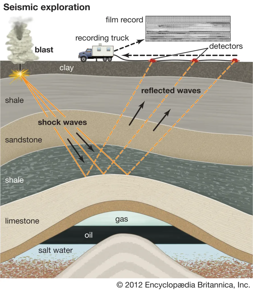
a. Seismic Reflection:
- Principle: Involves sending seismic waves into the subsurface and analyzing the reflected waves to image subsurface structures.Applications: Widely used in oil and gas exploration, subsurface mapping, and engineering studies.
- Principle: Analyzes the travel times of seismic waves refracted at subsurface interfaces to determine subsurface velocities and depth.Applications: Used in engineering, groundwater studies, and shallow subsurface investigations.
- Principle: Measures the propagation characteristics of surface waves traveling along the Earth’s surface.Applications: Used for shallow subsurface imaging, site characterization, and geotechnical studies.
- Principle: Involves deploying seismic sensors in boreholes to acquire high-resolution subsurface information.Applications: Used in oil and gas reservoir characterization, geological studies, and monitoring subsurface changes.
- Principle: Involves deploying seismic sources and receivers in different boreholes to study subsurface properties between boreholes.
- Applications: Commonly used in geotechnical investigations and characterization of subsurface materials.
These geophysical methods are often used in combination to obtain a comprehensive understanding of the subsurface conditions and geological structures in a given area. The choice of method depends on the specific objectives of the study and the characteristics of the subsurface materials being investigated.
Instrumentation and Equipment
The instrumentation and equipment used in geophysics vary depending on the specific geophysical method being employed. Each method requires specialized tools to measure and record the physical properties of the subsurface. Here is an overview of some common geophysical instruments and equipment:
1. Gravity Survey:
- Gravimeter: Measures variations in gravitational acceleration. Modern gravimeters are often based on superconducting technology for high precision.
2. Magnetic Survey:
- Magnetometer: Measures the strength and direction of the Earth’s magnetic field. Fluxgate and proton precession magnetometers are commonly used.
3. Electrical Resistivity Survey:
- Resistivity Meter: Measures the electrical resistivity of the subsurface materials. Various electrode configurations and arrays are used depending on the survey objectives.
4. Ground-Penetrating Radar (GPR):
- GPR System: Includes a control unit and antennas that emit and receive radar pulses. Antennas may vary in frequency for different penetration depths.
5. Electromagnetic (EM) Methods:
- EM Receiver and Transmitter: EM instruments consist of a transmitter that induces an electromagnetic field and a receiver that measures the response. Different coil configurations are used for various applications.
6. Seismic Reflection:
- Seismic Source (Vibroseis, Explosive, etc.): Generates seismic waves that penetrate the subsurface.
- Geophones: Detect ground motion and record seismic reflections. Arrays of geophones are used for data acquisition.
7. Seismic Refraction:
- Seismic Source (Explosive, Hammer, etc.): Produces seismic waves that refract at subsurface interfaces.
- Geophones: Measure the arrival times and amplitudes of refracted seismic waves.
8. Surface-Wave Methods:
- Accelerometers or Geophones: Measure ground motion caused by surface waves.
9. Downhole Seismic Methods:
- Downhole Seismic Sensors: Deployed in boreholes to record seismic waves at various depths.
10. Crosshole Seismic Methods:
- Seismic Sources and Receivers: Deployed in different boreholes for subsurface imaging between boreholes.
11. Remote Sensing:
- Satellite or Aircraft-Based Sensors: Include optical, infrared, radar, and other sensors for collecting data about the Earth’s surface.
12. Global Positioning System (GPS):
- GPS Receivers: Provide precise location information for ground-based instruments.
13. Data Acquisition and Processing Systems:
- Data Loggers and Recorders: Capture and store geophysical data during field surveys.
- Computers and Software: Process and interpret geophysical data to generate subsurface models.
14. Inclinometers and Tiltmeters:
- Inclinometers: Measure the angle of inclination of a borehole, providing information about subsurface stability.
- Tiltmeters: Measure small changes in tilt, often used for monitoring ground deformation.
15. Borehole Logging Tools:
- Various Tools: Gamma ray, resistivity, sonic, and other sensors are attached to a downhole toolstring for logging data within boreholes.
These instruments and equipment are integral to conducting geophysical surveys and experiments, allowing scientists and engineers to gather data about the Earth’s subsurface and make informed interpretations about geological structures, resource distribution, and environmental conditions. The advancement of technology has led to the development of more sophisticated and precise instrumentation in the field of geophysics.
Data Processing and Interpretation
Data processing and interpretation are crucial steps in geophysics, as they transform raw field measurements into meaningful information about the subsurface. The process involves handling, filtering, analyzing, and modeling geophysical data to extract valuable insights. Here’s an overview of the typical steps involved in data processing and interpretation in geophysics:
1. Data Pre-processing:
- Data Quality Check: Assess the quality of acquired data, identify and correct errors or anomalies.
- Noise Reduction: Apply filters and corrections to minimize noise and interference in the data.
- Coordinate System Transformation: Convert raw data into a consistent coordinate system for analysis.
2. Data Inversion:
- Mathematical Inversion: Use mathematical algorithms to invert observed data and estimate subsurface properties.
- Modeling: Employ numerical models to simulate subsurface conditions and compare with observed data.
3. Velocity Analysis (for Seismic Methods):
- Velocity Analysis: Determine the velocity of seismic waves in the subsurface to improve depth imaging.
- Migration: Apply migration algorithms to correct for the effects of velocity variations and improve subsurface imaging.
4. Filtering and Smoothing:
- Frequency Filtering: Remove unwanted frequencies or enhance specific frequency ranges in the data.
- Spatial Smoothing: Reduce noise and highlight coherent patterns by applying spatial smoothing techniques.
5. Time-Distance Conversion (for Seismic Methods):
- Time-Distance Conversion: Convert travel times of seismic waves to depth information for subsurface structure interpretation.
6. Data Integration:
- Integration of Multiple Data Sets: Combine data from various geophysical methods or other sources for a comprehensive subsurface characterization.
- Joint Inversion: Simultaneously invert multiple datasets to obtain a more accurate and consistent subsurface model.
7. Attribute Analysis:
- Attribute Extraction: Derive additional information (attributes) from the geophysical data, such as amplitude, phase, or frequency.
- Attribute Mapping: Create maps or sections highlighting specific attributes for interpretation.
8. Interpretation:
- Identification of Anomalies: Recognize anomalies or patterns in the data that may indicate geological features or subsurface changes.
- Correlation with Geological Models: Compare geophysical results with existing geological models to validate interpretations.
9. 3D Visualization:
- 3D Modeling: Develop three-dimensional models of the subsurface based on the interpreted data.
- Visualization Tools: Use software tools to visualize and manipulate 3D models for better understanding.
10. Uncertainty Analysis:
- Uncertainty Quantification: Assess the uncertainty associated with the interpreted results.
- Sensitivity Analysis: Evaluate the sensitivity of interpretations to changes in input parameters or assumptions.
11. Report Generation:
- Documentation: Prepare comprehensive reports documenting the data processing steps, methodologies, and interpretations.
- Presentation: Communicate findings through visual aids, graphs, and maps.
12. Iterative Approach:
- Iterative Refinement: The interpretation process may involve iterative refinement, where adjustments are made based on feedback and additional data.
Data processing and interpretation in geophysics require a combination of expertise in geology, physics, and mathematics. It’s a dynamic process that involves both scientific judgment and the use of advanced software tools. The goal is to derive accurate and meaningful information about the subsurface for applications in resource exploration, environmental studies, and geological investigations.
 Methods")
")


