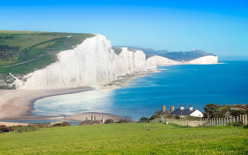
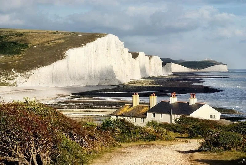
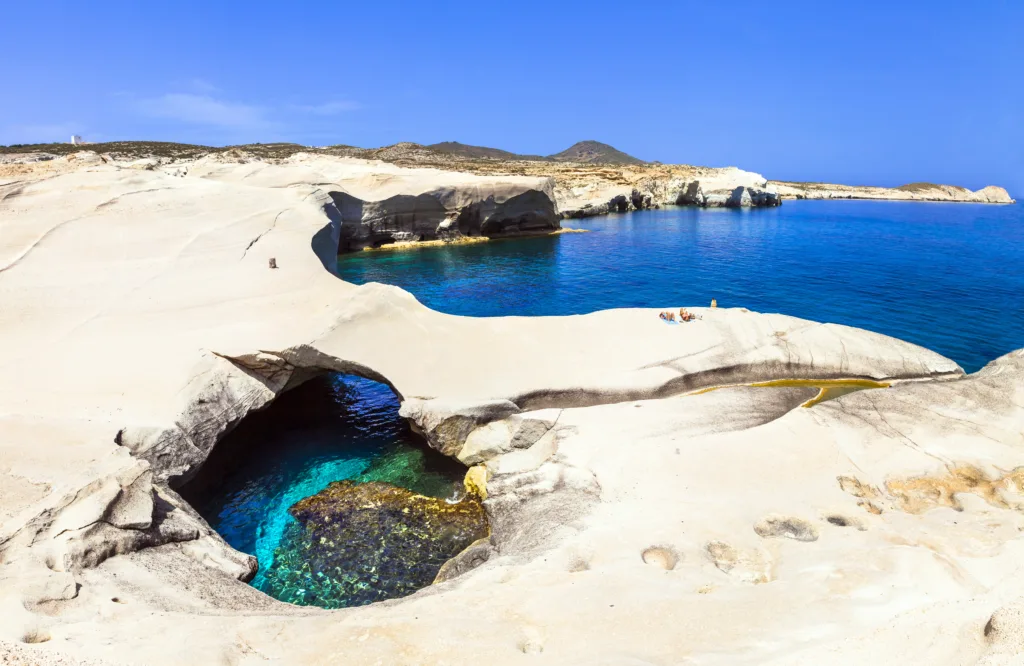
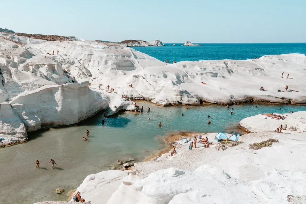
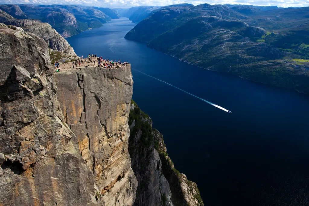
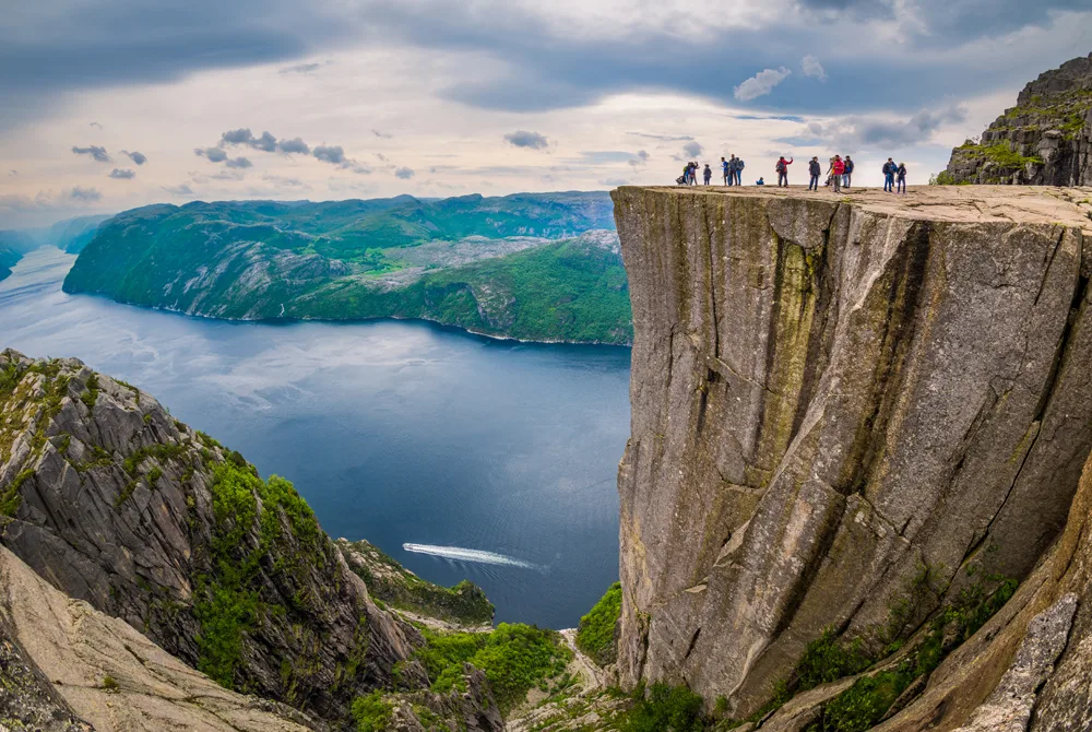
Al-Ula is a historic and culturally significant city located in the northwestern region of Saudi Arabia. It is part of the Al Madinah Province and covers an area of approximately 25,000 square kilometers. The city is nestled in a desert valley surrounded by towering sandstone mountains, offering a breathtaking natural setting.
The history of Al-Ula dates back thousands of years, with evidence of human habitation found in the area from prehistoric times. The region has been home to various civilizations, including the Nabataeans, Lihyanites, Romans, and Islamic empires, who all left their marks on the city through their architecture, art, and cultural practices.
One of the most iconic archaeological sites in Al-Ula is Madain Saleh, also known as Al-Hijr. This UNESCO World Heritage site is renowned for its well-preserved rock-cut tombs, reminiscent of the famous Petra in Jordan. The tombs showcase the architectural brilliance of the Nabataeans, who carved them into the sandstone cliffs.
Al-Ula is also home to other archaeological sites such as Dadan, an ancient city that was the capital of the Lihyanite Kingdom. Dadan features ancient temples, tombs, and remnants of an extensive city wall, providing valuable insights into the region’s historical and cultural past.
In recent years, Al-Ula has undergone significant development efforts to promote tourism and cultural preservation. The Saudi Arabian government has invested in infrastructure improvements, visitor facilities, and the restoration of archaeological sites. These efforts have positioned Al-Ula as a major cultural and tourist destination, attracting visitors from around the world.
The stunning natural landscapes of Al-Ula add to its allure. The sandstone formations, deep canyons, and oases create a captivating contrast against the arid desert surroundings. The region’s geological features, shaped by millions of years of erosion and tectonic activity, contribute to the scenic beauty and uniqueness of Al-Ula.
Al-Ula hosts various cultural events and festivals, including the Winter at Tantora festival, which celebrates the region’s heritage through music, art, and other cultural activities. The festival brings together renowned performers and artists from around the globe, offering a vibrant cultural experience against the backdrop of Al-Ula’s historic sites.
As Al-Ula continues to grow as a tourist destination, efforts are being made to strike a balance between development and preservation, ensuring the protection of its archaeological treasures and natural landscapes. The city’s rich history, architectural wonders, and breathtaking scenery make Al-Ula a captivating destination for those seeking to explore Saudi Arabia’s cultural and natural heritage.
Geological History of Al-Ula
Formation of the Arabian Peninsula: The geological history of Al-Ula is closely tied to the formation of the Arabian Peninsula. The Arabian Peninsula is part of the larger Arabian Plate, a tectonic plate that formed through a series of geological processes over millions of years.
The formation of the Arabian Peninsula began during the breakup of the supercontinent Pangaea in the Mesozoic Era, specifically during the Jurassic and Cretaceous periods. The region was part of the Tethys Sea, an ancient ocean that separated the supercontinents Laurasia and Gondwana.
During this period, sedimentary rocks were deposited in the Tethys Sea, including the Al-Ula Sandstone Formation that characterizes the landscape of Al-Ula today. These sedimentary rocks were formed from the accumulation of sand, silt, and clay particles, as well as the remains of marine organisms.
Tectonic history and plate movements in the region: The tectonic history of the region has been influenced by the collision and interaction of several tectonic plates. The Arabian Plate is bordered by the African Plate to the west and the Eurasian Plate to the north.
The collision between the Arabian Plate and the Eurasian Plate resulted in the formation of the Zagros Mountains in Iran and the Taurus Mountains in Turkey. This tectonic activity led to the uplift and deformation of the Arabian Plate, including the formation of mountain ranges and the creation of geological structures.
In the case of Al-Ula, the region is situated on the Arabian Shield, a Precambrian geological formation that forms the core of the Arabian Peninsula. The Arabian Shield consists of ancient crystalline rocks, such as granites and metamorphic rocks, which were formed during volcanic and mountain-building events in the Precambrian period.
Sedimentary processes and deposition in Al-Ula: The sedimentary rocks of Al-Ula, particularly the Al-Ula Sandstone Formation, provide evidence of the deposition and geological processes that occurred in the region.
During the Jurassic and Cretaceous periods, the Tethys Sea experienced extensive sedimentation. Rivers transported sediments from the surrounding land areas, including eroded rocks and organic matter, which were deposited in the sea.
Over time, these sediments were compacted and cemented, transforming them into the sandstone that we see today in Al-Ula. The layers of sandstone formed in horizontal beds, known as strata, with distinct patterns and textures.
The erosion and weathering of the sandstone have played a significant role in shaping the unique landscapes of Al-Ula. The arid climate, occasional flash floods, and wind erosion have sculpted deep canyons, carved rock formations, and created intricate patterns on the sandstone surfaces.
The sedimentary rocks of Al-Ula also preserve a record of ancient environments and past climates. Fossilized remains of marine organisms, such as shells and coral reefs, can be found in some sedimentary layers, providing insights into the ancient marine ecosystems that existed during the deposition of these rocks.
Understanding the sedimentary processes and deposition in Al-Ula allows geologists to reconstruct the geological history of the region and gain insights into the environmental changes that have occurred over millions of years.
Overall, the geological history of Al-Ula encompasses the formation of the Arabian Peninsula, tectonic events and plate movements, and the deposition of sedimentary rocks through various processes. These geological processes have shaped the landscapes and provided valuable insights into the region’s ancient environments and natural history.
Rock Types and Formations
Al-Ula in Saudi Arabia showcases a diverse range of rock types and formations, each with its own geological significance. Here are some of the notable rock types and formations found in the region:
Sandstone: Sandstone is one of the predominant rock types in Al-Ula. The Al-Ula Sandstone Formation, which dates back to the Jurassic and Cretaceous periods, is particularly prominent. The sandstone rocks have a distinctive reddish-brown hue and are characterized by their ability to be easily shaped by erosion, giving rise to the stunning cliffs, canyons, and rock formations in the area.
Basalt: Basalt is a volcanic rock that is present in the form of extensive lava fields, known as the Harrat, in and around Al-Ula. These basaltic lava flows originated from volcanic eruptions that occurred between the Miocene and Holocene epochs. The black-colored basalt landscapes offer a striking contrast to the surrounding sandstone formations.
Granite: Granite is a common intrusive igneous rock found in the Arabian Shield, the underlying geological formation of the Arabian Peninsula. It is composed mainly of quartz, feldspar, and micaminerals. Granite is recognized for its coarse-grained texture and durability. It can be seen in some areas surrounding Al-Ula, forming rugged mountains and providing a foundation for the landscape.
Limestone: Limestone, a sedimentary rock primarily composed of calcium carbonate, is also present in parts of Al-Ula. While not as abundant as sandstone, limestone can be found in certain areas. It often contains fossils and contributes to the geological diversity of the region.
Conglomerate: Conglomerate is a sedimentary rock made up of rounded pebbles and stones cemented together. It is occasionally encountered in Al-Ula, particularly in areas where ancient river channels or alluvial fans were present. Conglomerate formations add a unique texture and appearance to the landscape.
Volcanic Tuff: Volcanic tuff is a type of rock formed from volcanic ash and fragments of volcanic debris that have been compacted and lithified. While not as prevalent as sandstone and basalt, volcanic tuff can be found in some areas around Al-Ula, offering insights into past volcanic activity in the region.
These various rock types and formations contribute to the captivating geological landscape of Al-Ula. They bear witness to the processes of sedimentation, volcanic activity, erosion, and tectonic events that have shaped the region over millions of years, leaving behind a visual tapestry of colors, textures, and landforms.
Structural Geology
Structural geology plays a crucial role in understanding the geological features and formations present in the region. Here are some key aspects of structural geology relevant to Al-Ula:
Folding: Folding refers to the bending or curving of rock layers due to tectonic forces. In Al-Ula, folding has played a significant role in the formation of the sandstone cliffs, canyons, and mountains. The pressure and movement of the Earth’s crust over millions of years have caused the sandstone layers to fold, resulting in the unique structures seen in the landscape.
Faulting: Faulting occurs when there is a fracture or break in the Earth’s crust along which movement has taken place. Faults can be classified into different types, including normal faults, reverse faults, and strike-slip faults. In Al-Ula, various fault systems have influenced the development of the region. These faults may have contributed to the formation of canyons and valleys by creating pathways for erosion and altering the landscape.
Jointing: Joints are fractures in rocks where there has been no appreciable displacement or movement. They form as a result of the release of stress in the Earth’s crust. Joints are commonly observed in the sandstone and granite rocks of Al-Ula. They can affect the behavior of rocks by controlling their susceptibility to weathering and erosion.
Unconformities: Unconformities are gaps or missing sections in the geological record, typically indicating a period of erosion or non-deposition. They occur when older rocks are uplifted and eroded before younger rocks are deposited on top. Unconformities can be found in Al-Ula, providing evidence of past erosional events and changes in sedimentation patterns.
By studying structural geology in Al-Ula, geologists can gain insights into the forces and processes that have shaped the region over time. It helps in understanding the tectonic history, the formation of geological structures, and the geological evolution of the area. This knowledge is valuable not only for academic purposes but also for practical applications such as resource exploration, geological hazard assessment, and engineering projects in the region.
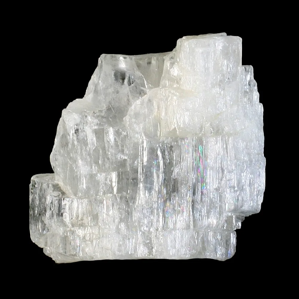
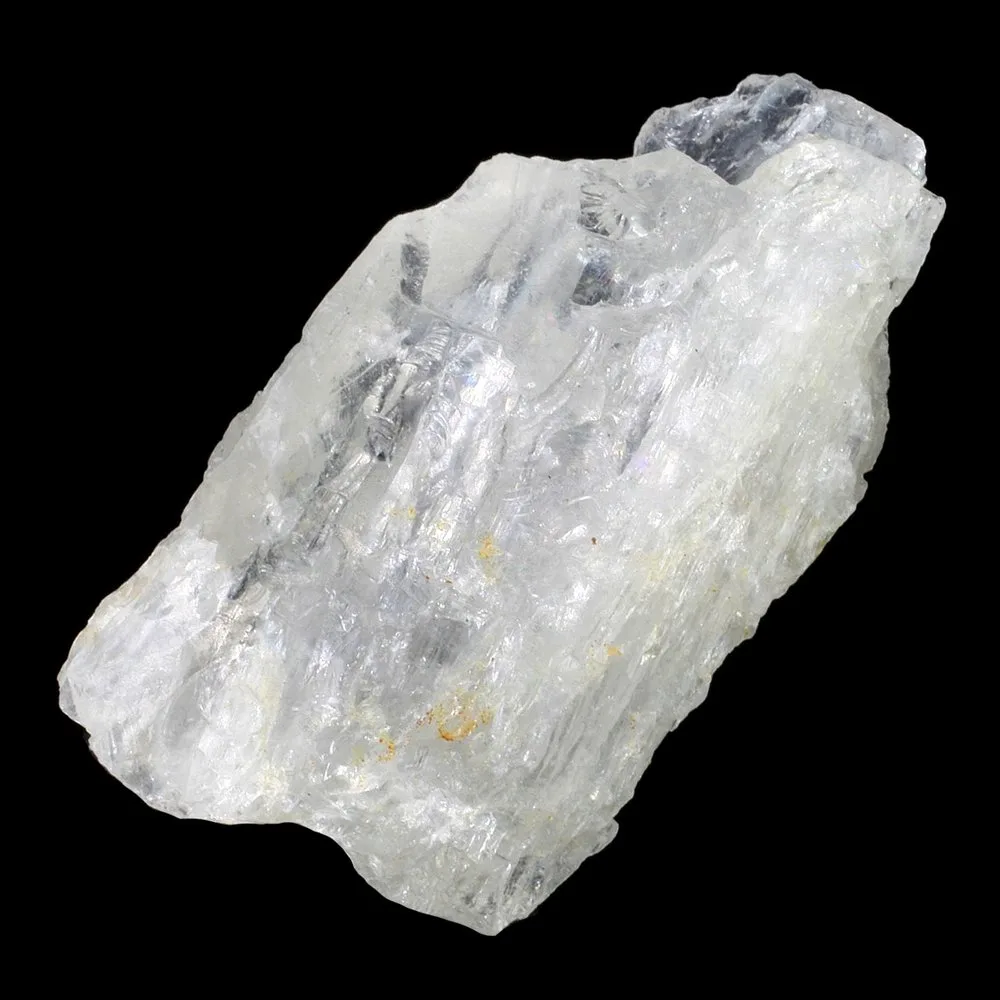
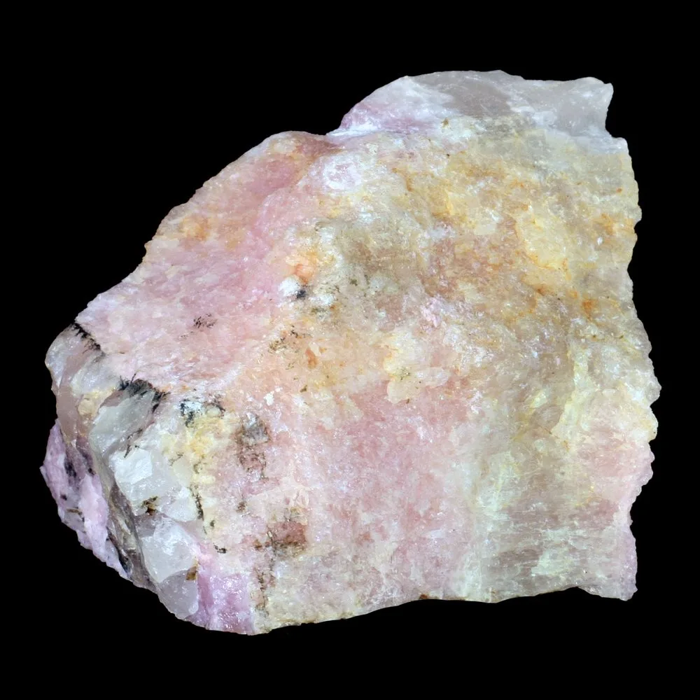
Petalite is a mineral that belongs to the group of silicate minerals known as feldspars. Its chemical formula is LiAl(Si4O10), indicating that it consists of lithium (Li), aluminum (Al), silicon (Si), and oxygen (O). Petalite typically forms in the monoclinic crystal system and has a hardness of 6.5 to 7 on the Mohs scale, making it relatively durable.
One of the distinctive characteristics of petalite is its colorless to white appearance, which can sometimes exhibit a pale pink or grey hue. It has a vitreous to pearly luster on its cleavage surfaces, and its transparent to translucent nature allows light to pass through it.
Occurrence and Sources of Petalite: Petalite is commonly found in granitic pegmatites, which are coarse-grained igneous rocks that form in the final stages of magma crystallization. It often occurs alongside other lithium-bearing minerals such as spodumene and lepidolite.
Significant deposits of petalite can be found in various regions worldwide, including Brazil, Sweden, Namibia, Australia, Zimbabwe, and the United States. Within the United States, petalite can be found in states such as California, South Dakota, and Colorado.
Industrial and Commercial Uses of Petalite:
Ceramics and Glass Industry: Petalite is valued for its low thermal expansion coefficient, which makes it useful in the production of ceramics and glass. It can be added to ceramic glazes and glass formulations to improve their thermal shock resistance.
Lithium Production: Petalite is an important source of lithium, a highly sought-after element used in the production of batteries for electronic devices, electric vehicles, and energy storage systems. Lithium extracted from petalite can be converted into lithium carbonate or lithium hydroxide, which are key components in lithium-ion batteries.
Gemstone and Jewelry: Although petalite is not widely known as a gemstone, certain varieties with good transparency and clarity can be cut and polished into faceted gemstones. These gemstones are typically used in jewelry, and their colorless appearance can resemble other gemstones like quartz.
Metaphysical and Healing Properties: Petalite is believed by some to possess metaphysical properties, including its ability to enhance meditation, bring calmness and emotional balance, and stimulate psychic abilities. It is sometimes used in alternative healing practices and crystal therapy.
It’s worth noting that while petalite has several industrial and commercial uses, its primary significance lies in its lithium content, which is crucial for the growing demand in battery technologies and sustainable energy storage solutions.
Physical Properties of Petalite
Color: Petalite is typically colorless to white, but it can also exhibit pale pink or grey tones.
Luster: Petalite has a vitreous to pearly luster on its cleavage surfaces, giving it a somewhat shiny appearance.
Transparency: Petalite is transparent to translucent, allowing light to pass through it to varying degrees.
Crystal System: Petalite crystallizes in the monoclinic crystal system, which means its crystal structure has three unequal axes, with one axis being perpendicular to the other two.
Hardness: Petalite has a hardness of 6.5 to 7 on the Mohs scale, which indicates that it is relatively durable and resistant to scratching.
Cleavage: Petalite exhibits good cleavage in two directions, which means it can be easily split along specific planes to form smooth surfaces.
Density: The density of petalite ranges from 2.4 to 2.5 grams per cubic centimeter, which is relatively low.
Refractive Index: The refractive index of petalite ranges from approximately 1.508 to 1.528, depending on the specific composition and impurities present.
Streak: The streak of petalite is white, meaning that when it is scratched on a streak plate, it leaves a white mark.
These physical properties contribute to the overall appearance and characteristics of petalite, making it a unique mineral with specific industrial, commercial, and aesthetic applications.
Geological Formation of Petalite
Petalite is primarily formed through the process of pegmatite formation, which occurs in the final stages of crystallization of igneous rocks. Here is an overview of the geological formation of petalite:
Magma Generation: Petalite formation begins with the generation of magma, which is molten rock that forms beneath the Earth’s surface. This magma typically originates from the partial melting of the Earth’s mantle or the lower crust.
Fractional Crystallization: As the magma rises towards the surface, it undergoes cooling and begins to crystallize. During this process, certain minerals crystallize out of the magma at different temperatures, leading to fractional crystallization. Early-formed minerals with higher melting points, such as olivine and pyroxene, crystallize first, leaving behind a more evolved melt.
Enrichment of Volatile Elements: As fractional crystallization continues, the residual melt becomes enriched in volatile elements, including lithium (Li). These elements have a tendency to be incompatible with the crystallizing minerals and prefer to remain in the liquid portion of the magma.
Formation of Pegmatites: The remaining melt, enriched in lithium and other volatiles, becomes highly concentrated and forms pockets of pegmatite. Pegmatites are coarse-grained igneous rocks characterized by exceptionally large crystals. They commonly occur in veins or dikes within surrounding rocks.
Crystallization of Petalite: Within the pegmatite, as the magma cools further, petalite crystals begin to form. Petalite is one of the minerals that can precipitate from the highly concentrated and volatile-rich residual melt. Other lithium-bearing minerals such as spodumene and lepidolite can also be present in the pegmatite.
Post-Crystallization Alterations: After the initial formation of petalite, the pegmatite may undergo secondary alterations due to geological processes such as hydrothermal activity, weathering, or metamorphism. These alterations can introduce additional minerals or modify the composition of existing minerals in the pegmatite.
Overall, the formation of petalite is closely associated with the final stages of fractional crystallization in the formation of pegmatites. The enrichment of volatile elements, including lithium, leads to the formation of petalite crystals within these unique geological environments.
Exploration and Mining of Petalite
Exploration Methods for Petalite: Exploration for petalite typically involves a combination of geological mapping, geochemical analysis, and geophysical surveys. Here are some common exploration methods used:
Geological Mapping: Geologists study the regional geology and identify areas with favorable geological settings for the occurrence of petalite. They examine the presence of lithium-bearing minerals in pegmatites and associated rock formations.
Geochemical Analysis: Geochemical analysis involves collecting and analyzing rock and soil samples to determine their lithium content. This helps identify areas with high lithium concentrations, which may indicate the presence of petalite-bearing pegmatites.
Geophysical Surveys: Various geophysical techniques, such as magnetic surveys, electromagnetic surveys, and radiometric surveys, can be employed to identify subsurface geological structures and anomalies that may host petalite deposits. These surveys help identify areas of interest for further exploration.
Remote Sensing: Remote sensing techniques, including satellite imagery and aerial photography, can be used to identify geological features associated with pegmatite occurrences. This method provides a broad-scale view of the terrain and can assist in narrowing down target areas for exploration.
Mining Techniques for Petalite: Once a petalite deposit is discovered and deemed economically viable, mining operations can commence. The specific mining techniques employed can vary depending on the scale and characteristics of the deposit. Here are some common mining methods for petalite:
Open-pit Mining: If the petalite deposit is near the surface and covers a large area, open-pit mining may be employed. This method involves the excavation of the ore body using heavy machinery, such as excavators and haul trucks. The overlying rock and waste material are removed to expose the petalite-bearing ore.
Underground Mining: In cases where the petalite deposit is located at significant depths, underground mining may be necessary. This method involves the construction of tunnels and shafts to access the ore body. Underground mining can be more expensive and complex but is often used for high-grade or deeper deposits.
Processing and Concentration: Once the petalite ore is extracted from the mine, it undergoes processing and concentration to separate and purify the lithium-bearing minerals. This process typically involves crushing, grinding, and various physical and chemical separation techniques to produce a concentrate with a high lithium content.
Environmental Considerations: Mining of petalite, like any mining activity, can have environmental impacts that need to be carefully managed. Here are some key environmental considerations:
Habitat Disturbance: Mining operations may involve the clearing of vegetation and removal of topsoil, leading to habitat loss and disruption of ecosystems. Efforts should be made to minimize the extent of habitat disturbance and implement reclamation and rehabilitation measures after mining activities are completed.
Water Management: Mining can have implications for water resources, including potential contamination from the release of chemicals or sediments. Proper water management practices, such as the construction of sedimentation ponds and water treatment facilities, are important to mitigate the impact on water quality.
Waste Management: Mining operations generate waste materials, including overburden, tailings, and potentially hazardous substances. Proper storage, containment, and disposal of these wastes are essential to prevent environmental contamination.
Energy Consumption and Greenhouse Gas Emissions: Mining operations consume energy, which can contribute to greenhouse gas emissions and climate change. Implementing energy-efficient practices and exploring renewable energy sources can help minimize the carbon footprint of mining operations.
Community Engagement: Engaging with local communities and stakeholders is crucial to address concerns, promote transparency, and ensure that the benefits and impacts of mining are appropriately managed. This includes considerations such as land rights, employment opportunities, and social and economic development.
Applications of Petalite
Lithium-ion Batteries: Petalite is an important source of lithium, a key component in lithium-ion batteries. These batteries are widely used in portable electronic devices like smartphones, laptops, and tablets, as well as electric vehicles (EVs) and renewable energy storage systems. The high lithium content in petalite makes it a valuable resource for the growing demand in the battery industry.
Ceramics and Glass Industry: Petalite’s low thermal expansion coefficient and high melting point make it useful in the ceramics and glass industry. It can be added to ceramic glazes and glass formulations to improve their thermal shock resistance and stability at high temperatures. Petalite is particularly valued in applications where resistance to thermal stress is required, such as cookware, crucibles, and high-temperature glassware.
Metallurgical Applications: Petalite’s lithium content has applications in the metallurgical industry. Lithium, extracted from petalite, can be used as a fluxing agent in the production of specialty glasses, enamels, and ceramics. Additionally, lithium is used in the aluminum smelting process as a degassing agent, improving the quality of the final aluminum product.
Gemstone and Jewelry: Petalite, when found in gem-quality crystals, can be cut and polished into faceted gemstones. Although not as widely recognized as other gemstones, petalite’s colorless to white appearance and good transparency can make it suitable for use in jewelry.
Metaphysical and Spiritual Practices: Petalite is believed by some to possess metaphysical and healing properties. It is associated with promoting calmness, emotional balance, and psychic abilities. Petalite is sometimes used in alternative healing practices, meditation, and crystal therapy.
It’s important to note that while petalite has various applications, its primary significance lies in its lithium content, which is crucial for the production of lithium-ion batteries. The demand for lithium-ion batteries is driven by the increasing adoption of portable electronic devices, electric vehicles, and renewable energy storage systems.
Petalite in Technology and Energy Storage
Role of Petalite in Lithium-Ion Battery Technology: Petalite plays a crucial role in lithium-ion battery technology as a source of lithium. Lithium-ion batteries are widely used in various applications, including portable electronic devices, electric vehicles (EVs), and energy storage systems. Petalite, with its high lithium content, provides a valuable resource for the production of lithium-ion batteries.
Lithium-ion batteries consist of a cathode, an anode, and an electrolyte. The cathode material commonly used in lithium-ion batteries is a lithium-containing compound, such as lithium cobalt oxide (LiCoO2), lithium iron phosphate (LiFePO4), or lithium nickelmanganese cobalt oxide (LiNiMnCoO2). Petalite can serve as a source of lithium in the production of these cathode materials.
Advantages and Disadvantages in Battery Applications: Advantages of using petalite in battery applications include:
Abundance: Petalite deposits are relatively abundant compared to other lithium-bearing minerals, ensuring a stable supply for battery production.
High Lithium Content: Petalite has a high lithium content, which makes it a valuable source for lithium-ion batteries.
Stability: Petalite exhibits good chemical stability, which is important for the long-term performance and safety of lithium-ion batteries.
Disadvantages of petalite in battery applications include:
Processing Challenges: Petalite requires processing and concentration to extract lithium. This process can be complex and costly, especially compared to other lithium sources like spodumene.
Lower Lithium Concentration: Petalite has a lower lithium concentration compared to some other lithium-bearing minerals. This can affect the overall energy density and performance of lithium-ion batteries.
Impact on Renewable Energy and Electric Vehicles: The availability of petalite and its use in lithium-ion batteries have a significant impact on renewable energy and electric vehicles:
Renewable Energy Storage: Petalite, as a source of lithium for lithium-ion batteries, contributes to the development of energy storage systems used in renewable energy applications. These batteries store excess energy generated by renewable sources like solar and wind power, allowing for a more reliable and sustainable energy supply.
Electric Vehicles (EVs): The growing demand for EVs relies heavily on the production of lithium-ion batteries. Petalite’s role as a lithium source helps enable the production of high-performance batteries for EVs, extending their driving range and improving their overall efficiency. Petalite contributes to the development of cleaner transportation alternatives and reduces dependence on fossil fuels.
The utilization of petalite in technology and energy storage is pivotal for the advancement of renewable energy solutions, the widespread adoption of electric vehicles, and the overall transition towards a more sustainable and low-carbon future.
Market Trends and Future Outlook
Global Production and Consumption Trends: The global production and consumption of petalite are closely linked to the demand for lithium-ion batteries and the growth of industries such as electronics, electric vehicles, and renewable energy storage. However, specific data on petalite production and consumption is not readily available, as it is often grouped together with other lithium sources like spodumene and lepidolite.
In recent years, there has been a significant increase in lithium demand due to the expanding market for electric vehicles and the growing need for energy storage solutions. As a result, the production of lithium has also been on the rise, with increased exploration and mining activities to meet the demand.
Price Fluctuations and Market Factors: The price of petalite, like other lithium sources, is influenced by various market factors. Some of these factors include:
Supply and Demand: The balance between supply and demand for lithium, driven by industries such as electric vehicles and renewable energy storage, can significantly impact the price of petalite. Increased demand and limited supply can lead to higher prices.
Technological Advancements: Advancements in lithium-ion battery technology, such as improvements in energy density and manufacturing processes, can influence the demand for petalite and other lithium sources. More efficient battery technologies can drive higher demand and potentially impact prices.
Government Policies and Regulations: Government policies and regulations, such as incentives for electric vehicles and renewable energy, can play a role in shaping the demand for lithium-ion batteries and, consequently, the demand for petalite.
Geopolitical Factors: Geopolitical factors, such as trade policies, export restrictions, and geopolitical tensions in lithium-producing regions, can impact the supply chain and prices of lithium sources.
Emerging Applications and Future Prospects: The future prospects for petalite are closely tied to the continued growth of the lithium-ion battery market and the expansion of electric vehicles and renewable energy storage. Some emerging applications and trends that may impact the demand for petalite include:
Grid-Scale Energy Storage: The increasing need for grid-scale energy storage systems to support the integration of renewable energy sources can drive the demand for petalite and other lithium sources.
Portable Electronics: The demand for lithium-ion batteries in portable electronic devices like smartphones, laptops, and wearable devices is expected to continue to grow. Petalite can play a role in meeting this demand.
Energy Transition and Sustainability: The global shift towards a low-carbon economy and the emphasis on sustainable energy solutions are expected to drive the demand for electric vehicles and renewable energy storage. This, in turn, can contribute to the demand for petalite and other lithium sources.
Research and Development: Ongoing research and development efforts are focused on improving lithium-ion battery technology, exploring alternative battery chemistries, and enhancing energy storage systems. These advancements may influence the future applications and demand for petalite.
Overall, the future outlook for petalite depends on the continued growth of the lithium-ion battery market, advancements in energy storage technologies, and the global transition towards cleaner and more sustainable energy solutions.
Summary of Key Points
Petalite is a lithium-bearing mineral that has various applications and significance. Here are the key points discussed:
Petalite is a mineral with a high lithium content, primarily formed through pegmatite formation.
It possesses physical properties such as hardness, low thermal expansion, and high melting point.
Petalite is explored using geological mapping, geochemical analysis, and geophysical surveys.
Mining techniques include open-pit mining and underground mining, followed by processing and concentration.
Petalite finds applications in lithium-ion batteries, ceramics and glass, metallurgical processes, gemstones, and metaphysical practices.
It plays a vital role in lithium-ion battery technology as a source of lithium.
Petalite has advantages such as its abundance, high lithium content, and stability but also has challenges in processing and lower lithium concentration.
It impacts renewable energy storage and the growth of electric vehicles.
The future outlook for petalite is dependent on the growth of lithium-ion battery demand, emerging applications, and advancements in energy storage technologies.
Importance and Relevance of Petalite
Petalite holds significant importance in several industries. Its primary importance lies in being a source of lithium for lithium-ion batteries, which are crucial for portable electronics, electric vehicles, and renewable energy storage. The demand for these applications is driven by the global shift towards sustainability and clean energy. Petalite’s physical properties and stability also make it valuable in the ceramics and glass industry. Furthermore, its use in gemstones and metaphysical practices adds to its relevance in the jewelry and spiritual sectors.
Potential for Future Research and Development
The future presents potential opportunities for research and development related to petalite. Some areas that could be explored include:
Processing Techniques: Research can focus on developing more efficient and cost-effective methods for extracting lithium from petalite and improving the concentration process.
Battery Technology: Continued research into lithium-ion battery technology, including advancements in energy density, cycle life, and safety, can further enhance the performance and reliability of batteries using petalite as a lithium source.
Alternative Energy Storage Systems: Investigating and developing alternative energy storage systems beyond lithium-ion batteries can open up new avenues for petalite and other lithium sources. This could include exploring technologies such as solid-state batteries, flow batteries, or other emerging energy storage solutions.
Sustainable Mining Practices: Research can be conducted to develop environmentally friendly and sustainable mining practices for petalite and other lithium sources, with a focus on minimizing environmental impacts and maximizing resource efficiency.
Overall, further research and development efforts can contribute to the optimization of petalite utilization, improve battery technologies, and ensure sustainable mining practices, thereby enhancing its role in the energy and technology sectors.
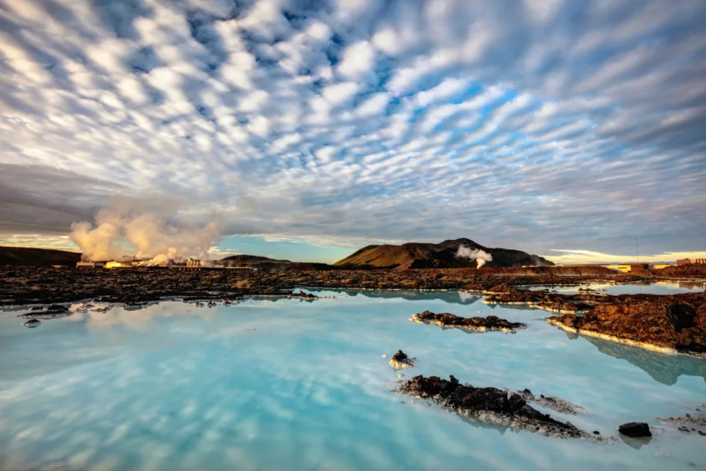
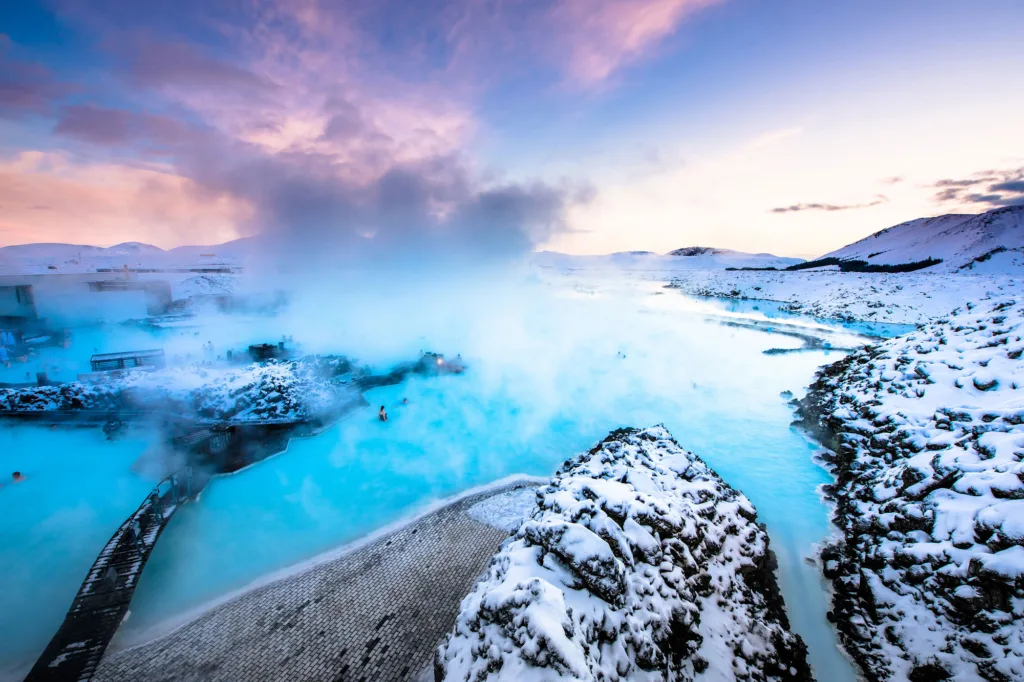
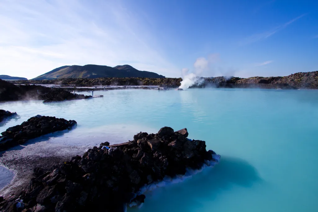
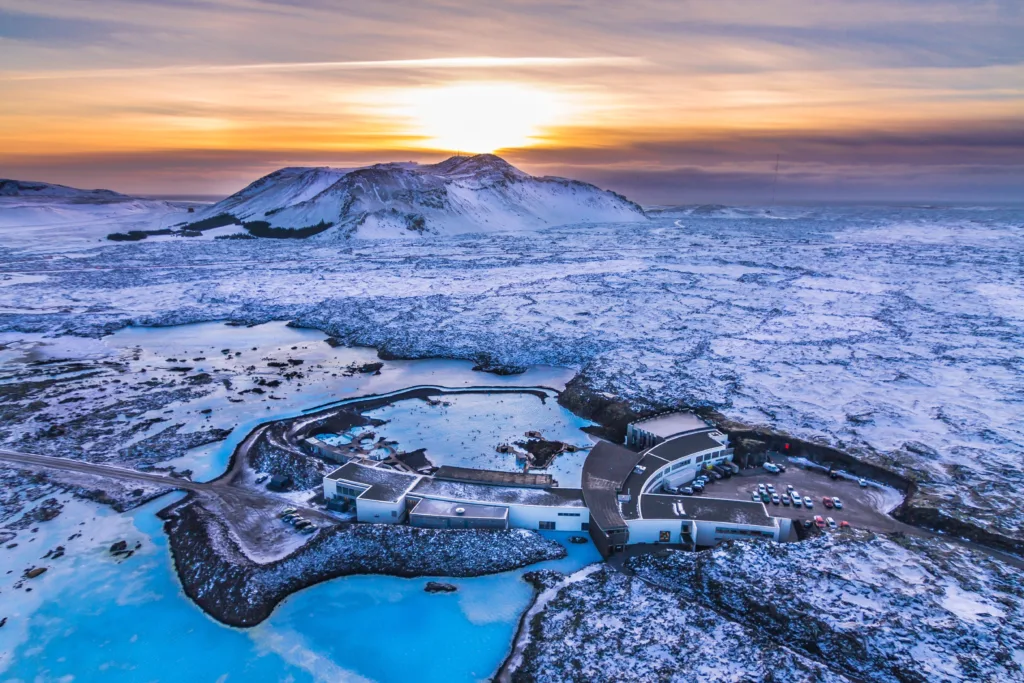
The Blue Lagoon is a geothermal spa located in southwestern Iceland, approximately 50 kilometers (31 miles) from the capital city, Reykjavik. It is one of Iceland’s most famous attractions and is renowned for its vivid blue-colored, mineral-rich waters. While the Blue Lagoon may appear to be a natural phenomenon, it is actually a man-made geothermal pool created by a nearby geothermal power plant.
The geology of the Blue Lagoon area is closely tied to Iceland’s unique geological features. Iceland sits atop the Mid-Atlantic Ridge, a tectonic boundary where the Eurasian and North American plates meet. This positioning makes Iceland a geologically active region with a high concentration of geothermal activity, including volcanic eruptions, geysers, and hot springs.
The Blue Lagoon is situated within a lava field formed by a volcanic eruption that occurred around 800 years ago. The lava field, known as the Svartsengi (Black Meadow), covers a significant area and is composed of dark basaltic rocks. Beneath the lava field lies a reservoir of geothermal seawater, heated by the Earth’s internal heat.
The geothermal power plant, Svartsengi Geothermal Power Station, taps into this reservoir to generate electricity and hot water for heating purposes. As a byproduct of the power plant’s operations, the excess geothermal seawater is discharged into the Blue Lagoon, creating a warm and mineral-rich bathing environment.
The unique blue color of the lagoon’s water is a result of the interaction between the silica-rich geothermal water and the sunlight. The water’s composition, which includes minerals like silica, algae, and other microorganisms, gives it its distinct milky blue appearance.
In addition to its aesthetic appeal, the Blue Lagoon is believed to have therapeutic qualities due to its mineral content. Visitors often indulge in bathing, mud masks, and other spa treatments that utilize the lagoon’s waters, which are said to have healing properties for various skin conditions such as psoriasis and eczema.
Over the years, the Blue Lagoon has become a popular tourist destination and a symbol of Iceland’s geothermal wonders. It showcases the country’s geological uniqueness and offers visitors a chance to immerse themselves in a one-of-a-kind natural spa experience.
Formation of the Blue Lagoon
The formation of the Blue Lagoon can be attributed to the Svartsengi Geothermal Power Station and its activities in harnessing geothermal energy. Here is an overview of the formation process:
Geothermal Seawater Source: The Blue Lagoon’s water originates from a reservoir of geothermal seawater that lies beneath the Svartsengi lava field. This seawater is a mixture of groundwater and seawater that has been heated by the Earth’s geothermal heat.
Geothermal Power Plant Operations: The Svartsengi Geothermal Power Station, located near the Blue Lagoon, harnesses the geothermal energy by extracting the superheated water from the underground reservoir. The water is used to drive turbines, generating electricity and producing hot water for heating purposes in nearby communities.
Water Discharge: As a result of the power plant’s operations, excess geothermal seawater is discharged from the power plant into the surrounding area. Initially, this water was released into the nearby lava field.
Water and Lava Interaction: When the superheated geothermal seawater comes into contact with the cold lava field, a series of chemical reactions occur. The water dissolves minerals, primarily silica, from the surrounding volcanic rock, creating a unique mineral-rich composition.
Formation of the Blue Lagoon: Over time, the discharge of the geothermal seawater into the lava field formed a man-made pool, which eventually became known as the Blue Lagoon. The pool gradually expanded and took on its characteristic vivid blue color due to the interaction between the silica-rich water and sunlight.
Human Intervention: To enhance the Blue Lagoon as a bathing and spa facility, human interventions were made. The pool’s bottom was paved, and facilities such as changing rooms, walkways, and spa amenities were added to accommodate visitors.
It’s important to note that the Blue Lagoon is not a naturally occurring geothermal pool but rather a result of the interaction between the geothermal power plant’s operations, the discharge of heated seawater, and the surrounding geological environment. However, despite its artificial origin, the Blue Lagoon has become a natural marvel and an iconic destination in Iceland.
Hydrothermal Systems
Hydrothermal systems are geological systems that involve the circulation of hot water or steam in the Earth’s crust. These systems are driven by heat generated from magma or the natural decay of radioactive elements in the Earth’s interior. Hydrothermal systems are found in various geologic settings, including volcanic regions, geothermal areas, and areas with active tectonic activity.
The key components of a hydrothermal system are:
Heat Source: The heat required to drive a hydrothermal system comes from the Earth’s internal heat. This heat can originate from the molten magma beneath the Earth’s surface or from the natural radioactive decay of elements like uranium, thorium, and potassium.
Water Reservoir: A hydrothermal system requires a reservoir of water. This water can come from various sources, including rainfall, surface water, or groundwater that has infiltrated into the subsurface. In some cases, the water may be seawater that has percolated through porous rocks.
Permeable Pathway: The water needs a permeable pathway through which it can circulate. This pathway is typically provided by fractures, faults, or porous rocks that allow the water to move through the subsurface.
Circulation: As the hot water or steam is heated by the heat source, it becomes buoyant and rises towards the surface. This circulation is driven by convection, where the hot fluids rise and the cooler fluids sink. The circulating fluids carry heat and dissolved minerals from the depths of the system.
Alteration and Mineralization: As the hot water or steam circulates through the hydrothermal system, it can interact with the surrounding rocks, causing alteration and mineralization. The hot fluids can react with the minerals in the rocks, leading to the formation of new minerals and the alteration of the original rock composition. This process can result in the deposition of valuable minerals, such as gold, silver, copper, and other metallic ores.
Hydrothermal systems can manifest in various forms, including geysers, hot springs, fumaroles (openings that emit steam and gases), and hydrothermal vents on the ocean floor. These systems play a crucial role in Earth’s geologic processes, influencing the formation of mineral deposits, shaping volcanic activity, and providing unique habitats for specialized organisms.
In addition, hydrothermal systems have practical significance. Geothermal energy, for example, is harnessed from hydrothermal systems to generate electricity and provide heating and cooling for residential and industrial use. The hot water and steam from these systems can also be utilized in spas and wellness resorts for therapeutic and recreational purposes.
Mineral Content and Chemistry of Blue Lagoon
The Blue Lagoon in Iceland is known for its mineral-rich waters, which contribute to its unique color and potential therapeutic properties. Here is an overview of the mineral content and chemistry of the Blue Lagoon:
Silica (Silicon Dioxide): Silica is one of the key minerals found in the Blue Lagoon. It is responsible for the lagoon’s milky blue appearance. The silica-rich water reflects sunlight, creating the vibrant blue color. Silica also contributes to the water’s viscosity, giving it a smooth and gel-like texture.
Algae and Minerals: The Blue Lagoon contains a variety of algae and other microorganisms. These organisms thrive in the warm, mineral-rich environment. Algae can contribute to the water’s bluish-green tint and can provide additional health benefits to the skin.
Minerals and Trace Elements: The geothermal seawater of the Blue Lagoon contains a range of minerals and trace elements, including:
Sodium: Sodium ions (Na+) are abundant in the water and contribute to its salinity.
Calcium: Calcium ions (Ca2+) are present in the water and can contribute to the lagoon’s potential therapeutic effects on the skin.
Magnesium: Magnesium ions (Mg2+) are present in significant amounts and are believed to have a soothing effect on the skin.
Potassium: Potassium ions (K+) are found in the water and play a role in maintaining the body’s electrolyte balance.
Sulfur: Sulfur compounds are present in the water and give off a distinct odor. Sulfur is known for its potential anti-inflammatory and antibacterial properties.
Chloride: Chloride ions (Cl-) are present and contribute to the overall salinity of the water.
Other trace elements: The water may contain trace amounts of elements like iron, zinc, manganese, and others, which can have various effects on the skin and overall well-being.
pH and Alkalinity: The Blue Lagoon has a slightly alkaline pH, typically ranging from around 7.5 to 8.5. The alkaline nature of the water can help to balance the skin’s pH and provide a soothing effect.
It’s important to note that the mineral content of the Blue Lagoon can vary, and the precise concentrations may change over time. The specific composition of minerals and trace elements contributes to the unique properties of the Blue Lagoon’s waters and is believed to offer potential benefits for skin health and well-being.
Geothermal Activity in Iceland
Iceland is renowned for its abundant geothermal activity, which is a direct result of its location on the Mid-Atlantic Ridge—a tectonic boundary where the Eurasian and North American plates meet. Here are some key aspects of geothermal activity in Iceland:
Volcanism: Iceland is a highly volcanic region, with numerous active volcanoes and volcanic systems. The island sits on a hot spot, where magma from the Earth’s mantle rises to the surface, leading to frequent volcanic eruptions. The volcanic activity provides the heat source for Iceland’s geothermal systems.
Geothermal Power Generation: Iceland harnesses its geothermal resources for electricity generation and heating. Geothermal power plants tap into the superheated water and steam reservoirs beneath the Earth’s surface to drive turbines, producing electricity. The country has a significant reliance on geothermal energy, with a substantial portion of its electricity and heating needs met through geothermal power plants.
Hot Springs: Iceland is dotted with numerous hot springs, which are geothermal features where hot water from underground reservoirs emerges at the surface. The hot springs vary in size and temperature, providing unique bathing experiences for locals and tourists alike. Some popular hot springs include the Blue Lagoon, Mývatn Nature Baths, and Landmannalaugar hot springs.
Geothermal Areas: Iceland has several geothermal areas characterized by a concentration of geothermal features, such as geysers, fumaroles, and hot springs. The most famous geothermal area is the Haukadalur Geothermal Valley, home to the renowned Geysir and Strokkur geysers. These areas showcase the dynamic nature of geothermal activity, with geysers erupting and hot springs emitting steam and gases.
Geothermal Heating: Geothermal energy is widely used for heating purposes in Iceland. Hot water from geothermal sources is distributed through a network of pipes to heat homes, buildings, and even sidewalks in urban areas. This geothermal heating system takes advantage of the natural warmth beneath the Earth’s surface and provides a sustainable and efficient heating solution for Icelandic communities.
Geothermal Research and Innovation: Iceland’s abundant geothermal resources have made it a hub for geothermal research and innovation. The country hosts research institutions, geothermal conferences, and geothermal companies that develop new technologies and explore geothermal energy potential both domestically and globally.
The geothermal activity in Iceland is not only a valuable source of renewable energy but also a significant natural attraction, drawing visitors from around the world to experience the unique geothermal features, hot springs, and geothermal spas that showcase Iceland’s geologic wonders.
The history of the Blue Lagoon and its discovery
The history of the Blue Lagoon can be traced back to the 1970s when it was accidentally discovered as a byproduct of the nearby Svartsengi Geothermal Power Station. Here is an overview of the history and discovery of the Blue Lagoon:
Formation of the Svartsengi Geothermal Power Station: In the early 1970s, the Svartsengi Geothermal Power Station was constructed near Grindavík, in southwestern Iceland. The power station was built to harness the geothermal energy from the underground reservoirs to generate electricity and provide heating for nearby communities.
Discharge of Geothermal Seawater: As part of the power station’s operations, excess geothermal seawater, heated by the geothermal processes, was discharged into the surrounding lava field. Initially, the water was released into the rugged and barren landscape.
Discovery by Locals: Local residents, curious about the warm and mineral-rich water, began bathing in the discharge site. They noticed that the water had potential therapeutic effects on various skin ailments, such as psoriasis and eczema. The warm and soothing water quickly gained popularity among the locals.
Recognition of Health Benefits: The positive reports about the water’s health benefits spread, and the site gained recognition for its potential therapeutic properties. People from nearby towns and cities started visiting the site to experience the healing effects of the water.
Development as a Spa: Recognizing the growing interest and potential for tourism, the site was further developed to accommodate visitors. Facilities such as changing rooms, showers, and walkways were added to enhance the visitor experience.
Opening of the Blue Lagoon: In 1987, the Blue Lagoon officially opened as a public bathing and spa facility. It quickly gained popularity among both domestic and international visitors due to its unique geothermal properties, vibrant blue color, and purported health benefits.
Ongoing Development and Expansion: Over the years, the Blue Lagoon has undergone continuous development and expansion to cater to the increasing number of visitors. Additional amenities and services, including a luxury hotel, restaurants, and spa treatments, have been introduced to provide a comprehensive wellness experience.
Today, the Blue Lagoon is one of Iceland’s most famous and iconic attractions, attracting hundreds of thousands of visitors each year. It is renowned for its mineral-rich waters, striking blue color, and the opportunity to relax and rejuvenate in a stunning geothermal setting.
Visitor Experience Blue Lagoon
Visiting the Blue Lagoon offers a unique and memorable experience for visitors. Here is an overview of what you can expect during a visit to the Blue Lagoon:
Arrival and Check-In: Upon arrival at the Blue Lagoon, you will proceed to the check-in area, where you will present your reservation or purchase a ticket. The staff will provide you with a wristband or electronic device that serves as your entry pass and may also be used for purchasing additional services.
Changing Facilities: The Blue Lagoon provides modern and well-equipped changing rooms where you can store your belongings and change into your swimwear. Showers are available to ensure proper hygiene before entering the lagoon.
Entry to the Lagoon: Once you’re ready, you can enter the lagoon area. The lagoon is an outdoor pool surrounded by rugged volcanic landscapes, creating a unique and picturesque setting. You can take in the breathtaking views and immerse yourself in the warm, mineral-rich waters.
Bathing in the Lagoon: You are free to explore the lagoon at your own pace. The water temperature is comfortably warm, ranging from around 37°C to 40°C (98°F to 104°F), offering a relaxing and soothing experience. You can enjoy floating, swimming, or simply lounging in the water while taking in the surrounding scenery.
Silica Mud Masks: As part of the Blue Lagoon experience, you’ll have the opportunity to apply silica mud masks to your face and body. These masks are made from the silica-rich mud found in the lagoon and are believed to have cleansing and rejuvenating effects on the skin. You can typically find buckets of the mud available around the lagoon’s edge.
Water Massage and Waterfalls: The Blue Lagoon features areas with water massage jets and waterfalls. These hydrotherapy features offer a relaxing massage-like experience, allowing you to enjoy the soothing effects of the warm water on your body.
Relaxation Areas: The Blue Lagoon provides designated relaxation areas where you can take a break from the water. These areas often include benches, lounge chairs, and umbrellas, allowing you to unwind and enjoy the tranquil ambiance of the lagoon surroundings.
Additional Services: The Blue Lagoon offers a range of additional services that you can avail yourself of, such as in-water massages, spa treatments, and beauty services. These services usually require prior booking and come at an additional cost.
Dining and Refreshments: The Blue Lagoon has on-site restaurants and cafes where you can grab a bite to eat or enjoy a refreshing drink. The menus often include a selection of Icelandic and international dishes, allowing you to savor the flavors while enjoying the views.
Shopping: Before leaving the Blue Lagoon, you can explore the on-site shop where you can find skincare products, souvenirs, and other merchandise related to the Blue Lagoon and Icelandic culture.
It’s important to note that reservations are typically required to visit the Blue Lagoon, especially during peak seasons, to ensure a smooth and enjoyable experience. Additionally, it’s advisable to follow the guidelines and instructions provided by the staff to maintain safety and respect the environment.
Overall, a visit to the Blue Lagoon offers a combination of relaxation, wellness, and stunning natural beauty, allowing you to immerse yourself in Iceland’s unique geothermal wonders.
FAQs
Is it necessary to make a reservation to visit the Blue Lagoon?
Yes, it is highly recommended to make a reservation in advance, especially during peak seasons. This ensures your entry to the lagoon at your preferred date and time.
Can I visit the Blue Lagoon without bathing?
No, the primary purpose of visiting the Blue Lagoon is to enjoy the bathing experience. However, there are observation decks where non-bathers can accompany visitors and still enjoy the view.
Are children allowed in the Blue Lagoon?
Yes, children are welcome at the Blue Lagoon. However, there are age restrictions for children, and they must be accompanied by adults. Specific rules and guidelines for children’s entry and bathing apply, so it’s advisable to check the Blue Lagoon’s official website for detailed information.
Can I bring my own towels and bathrobes?
Yes, you are allowed to bring your own towels and bathrobes. However, the Blue Lagoon provides towels for rent, and bathrobes are available for purchase or rent as well. It can be more convenient to use the facilities provided on-site.
Are there locker facilities available?
Yes, the Blue Lagoon provides locker facilities where you can securely store your belongings. These lockers are typically operated using electronic wristbands or cards provided to you upon entry.
Can I wear my contact lenses in the lagoon?
It is generally recommended to avoid wearing contact lenses in the lagoon due to the high mineral content of the water. The minerals can interact with the lenses and cause discomfort. It is advisable to bring your glasses or prescription goggles instead.
Can I visit the Blue Lagoon if I have a skin condition?
The Blue Lagoon is renowned for its potential therapeutic effects on certain skin conditions, such as psoriasis and eczema. However, it’s always best to consult with your healthcare provider before visiting if you have any specific concerns or conditions.
Is there a time limit for how long I can stay in the lagoon?
There is no strict time limit for how long you can stay in the lagoon. You are generally allowed to spend as much time as you like within the operating hours of the Blue Lagoon.
Can I bring my own food and drinks?
Outside food and drinks are not allowed in the Blue Lagoon. However, the facility has on-site restaurants and cafes where you can purchase food and beverages.
Can I visit the Blue Lagoon in winter?
Yes, the Blue Lagoon is open year-round, including during the winter months. It can be a particularly enchanting experience to bathe in the warm waters while surrounded by the snowy landscape. Just remember to dress warmly before and after your visit.
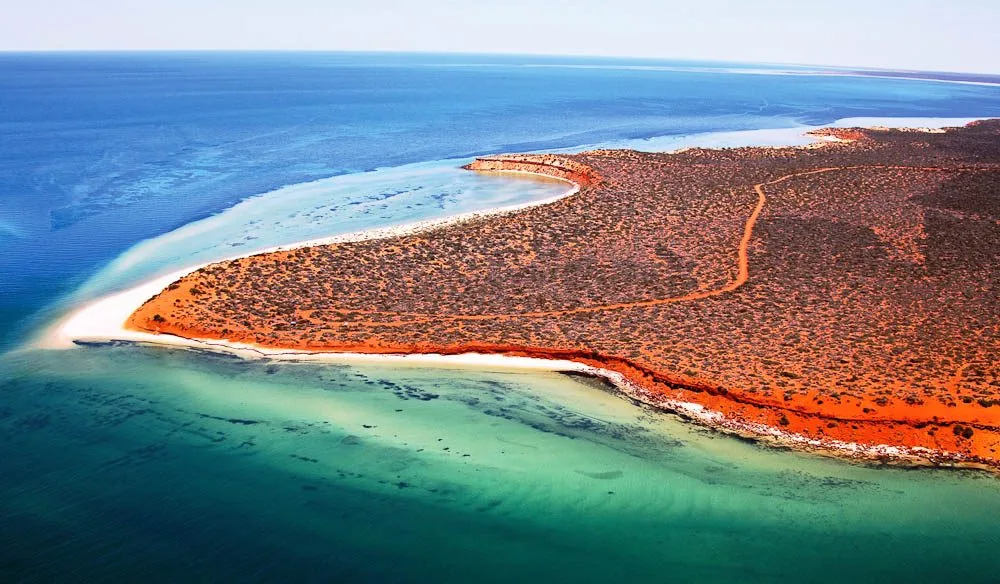
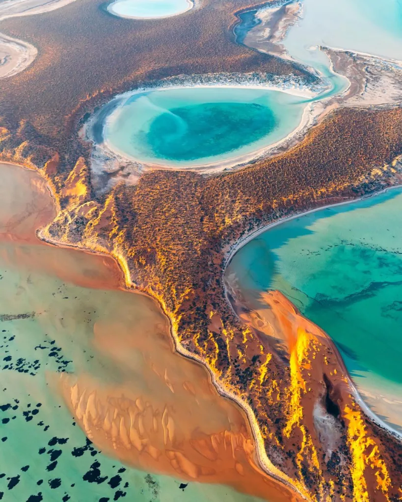
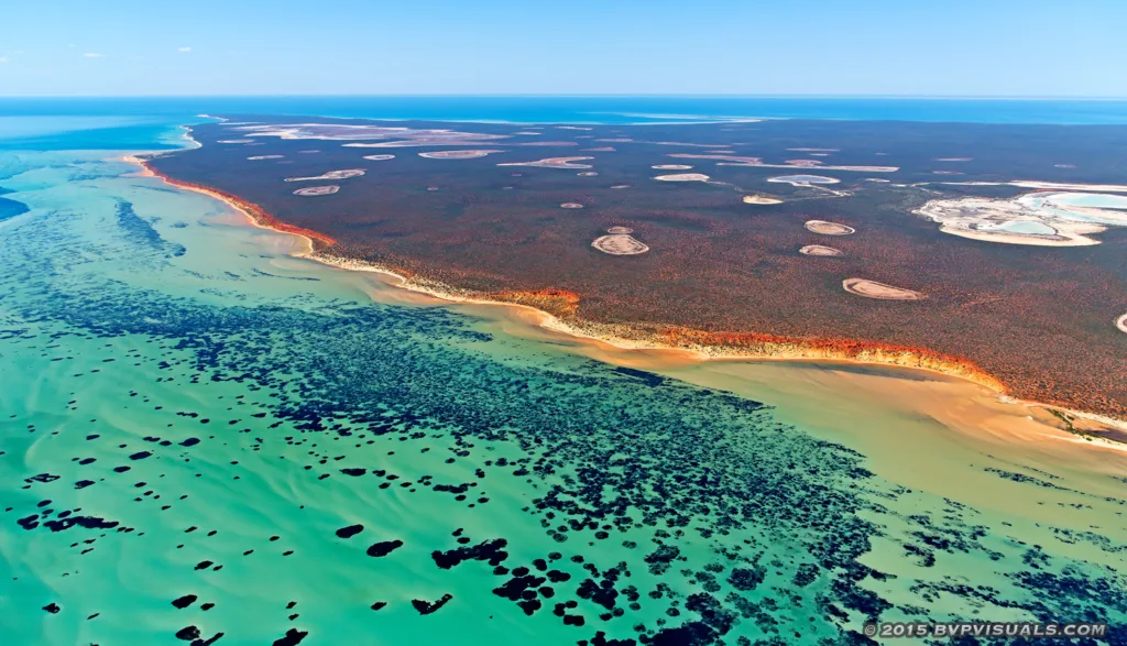
Las Coloradas is a unique and visually stunning site located in the state of Yucatan, Mexico. It is renowned for its vibrant pink-hued lakes that captivate visitors from around the world. The geology of Las Coloradas plays a significant role in creating this breathtaking natural phenomenon.
Las Coloradas is situated along the northern coast of the Yucatan Peninsula, near the town of Río Lagartos. The region is characterized by its flat topography and limestone bedrock, which is common throughout the Yucatan Peninsula. The Yucatan Peninsula is primarily composed of a massive limestone platform known as the Yucatan Platform or the Yucatan Shelf.
The Yucatan Platform was formed during the Late Cretaceous period, approximately 65 to 100 million years ago, when the area was covered by a shallow sea. Over millions of years, the accumulation of marine sediments, including coral reefs, shells, and other organic materials, led to the formation of the limestone rock that comprises the Yucatan Peninsula today.
One of the key factors that contributes to the distinctive pink color of the lakes in Las Coloradas is the presence of high concentrations of salt and minerals, particularly sodium sulfate and calcium carbonate. These minerals are brought to the surface through a combination of underground water sources and the effects of evaporation.
Las Coloradas is situated within the Ría Lagartos Biosphere Reserve, which is a protected area known for its rich biodiversity, including numerous species of birds, fish, and other wildlife. The reserve encompasses a network of estuaries, mangroves, and wetlands, creating a unique ecosystem that supports a wide range of flora and fauna.
The pink lakes of Las Coloradas owe their vibrant color to the interaction between the mineral-rich waters and the microscopic algae and bacteria present in the lakes. These microorganisms thrive in the high-salinity environment and produce pigments that give the water its distinctive pink color.
The pink lakes of Las Coloradas have become a popular tourist attraction, drawing visitors who are mesmerized by the surreal beauty of the landscape. Visitors can observe the vibrant pink hues up close and even take guided tours to learn more about the geology, ecology, and cultural significance of the area.
It is important to note that while Las Coloradas is a natural wonder, it is crucial to respect the delicate ecosystem and follow responsible tourism practices to preserve the site for future generations to enjoy.
Pink Salt Lakes
The unique pink color of the salt lakes in Las Coloradas is primarily caused by the presence of certain microorganisms, particularly algae and bacteria. These microorganisms produce pigments that give the water its vibrant pink hue.
The formation of the salt lakes begins with the geological composition of the area. The region sits atop a limestone platform, which is rich in minerals such as sodium sulfate and calcium carbonate. Underground water sources carry these minerals to the surface, where they accumulate in shallow, salty pools.
The high salinity of the water creates an extreme environment that is inhospitable for many forms of life. However, certain microorganisms, known as halophiles, have adapted to thrive in such conditions. These microorganisms include various species of algae and bacteria that have specialized pigments, such as carotenoids, which give them the ability to survive and multiply in the high-salinity environment.
As the microorganisms multiply, they form dense populations in the lakes, resulting in a phenomenon called “blooms.” These blooms can vary in color, ranging from pink to red or even orange, depending on the specific types and concentrations of microorganisms present.
The pigments produced by the microorganisms serve a variety of purposes. Some pigments act as protection against the intense sunlight and UV radiation in the region, while others help the microorganisms absorb light for photosynthesis. These pigments, particularly the carotenoids, are responsible for the pink coloration of the water.
The ecological importance of these microorganisms in the salt lakes of Las Coloradas is significant. They form the base of the food chain, providing a source of nutrients for other organisms, such as certain species of shrimp and birds that feed on them. The lakes also support a diverse array of bird species, including flamingos, which are attracted to the rich food source provided by the microorganisms.
Furthermore, the salt lakes in Las Coloradas are part of the larger ecosystem of the Ría Lagartos Biosphere Reserve. The presence of these unique lakes contributes to the overall biodiversity of the reserve, providing habitats for a variety of species of birds, fish, and other wildlife.
It is important to note that the delicate balance of the ecosystem in Las Coloradas relies on maintaining the appropriate conditions for the microorganisms to thrive. Any disruption to the natural processes or excessive human intervention could have negative consequences for the ecosystem and the vibrant pink lakes. Therefore, it is crucial to practice responsible tourism and conservation efforts to preserve the ecological integrity of Las Coloradas.
Tourism and recreational activities around the salt
Tourism and recreational activities around the salt lakes of Las Coloradas have become increasingly popular due to the unique and mesmerizing pink landscapes. Visitors have the opportunity to engage in various activities that allow them to explore and appreciate the natural beauty of the area. Here are some of the tourism and recreational activities available:
Guided Tours: Local tour operators offer guided tours of the salt lakes, providing visitors with insights into the geology, ecology, and cultural significance of Las Coloradas. These tours often include visits to different parts of the lakes, allowing visitors to witness the striking pink hues up close.
Photography: The surreal and vibrant pink lakes offer photographers an extraordinary opportunity to capture stunning and memorable images. The contrast between the pink water and the surrounding white salt formations creates a visually striking setting for photography enthusiasts.
Birdwatching: The salt lakes of Las Coloradas attract a diverse range of bird species, including flamingos, herons, egrets, and many others. Birdwatching enthusiasts can observe these beautiful creatures in their natural habitat, capturing unique bird sightings and behaviors.
Boat Tours: Boat tours are available in the nearby Río Lagartos area, allowing visitors to explore the estuaries, mangroves, and wetlands surrounding Las Coloradas. These tours offer opportunities to spot wildlife such as crocodiles, dolphins, and various bird species.
Salt Lake Swimming: While swimming is not permitted in all areas of the salt lakes, there are specific designated spots where visitors can safely enjoy a swim. These areas typically have less salt concentration, allowing for a refreshing dip in the pink waters.
Relaxation and Beach Time: Along the coast of Las Coloradas, there are pristine sandy beaches where visitors can relax, sunbathe, and enjoy the tranquility of the area. The scenic beauty and peaceful atmosphere make it an ideal spot for a day of leisure.
Local Culture and Cuisine: Exploring the nearby town of Río Lagartos provides an opportunity to experience the local culture and sample traditional Yucatecan cuisine. Visitors can try delicious seafood dishes and interact with the friendly locals.
It’s important to note that while enjoying these recreational activities, it is crucial to follow responsible tourism practices and respect the natural environment. This includes avoiding littering, keeping a safe distance from wildlife, and adhering to any guidelines or regulations set by local authorities to preserve the ecological integrity of the salt lakes and surrounding areas.
FAQs
How do the salt lakes of Las Coloradas get their pink color?
The pink color of the salt lakes in Las Coloradas is primarily due to the presence of microorganisms, such as algae and bacteria, that produce pigments, particularly carotenoids. These pigments give the water its vibrant pink hue.
Can you swim in the salt lakes?
Swimming is generally not permitted in all areas of the salt lakes. However, there are specific designated spots where visitors can safely enjoy a swim. These areas typically have lower salt concentrations, allowing for a more pleasant swimming experience.
Are the salt lakes natural or man-made?
The salt lakes of Las Coloradas are natural formations. They are a result of geological processes, including the accumulation of minerals and evaporation, combined with the presence of microorganisms that give them their unique pink color.
Can I take a guided tour of the salt lakes?
Yes, guided tours are available in Las Coloradas. Local tour operators offer guided tours that provide insights into the geology, ecology, and cultural significance of the area. These tours often include visits to different parts of the salt lakes, allowing visitors to witness the pink hues up close.
What other attractions are there in Las Coloradas?
Apart from the salt lakes, Las Coloradas is located near the Ría Lagartos Biosphere Reserve, which is known for its diverse ecosystem and abundant wildlife. Visitors can explore the estuaries, mangroves, and wetlands, where they may encounter various bird species, crocodiles, dolphins, and more.
How can I get to Las Coloradas?
Las Coloradas is located on the northern coast of the Yucatan Peninsula in Mexico, near the town of Río Lagartos. The nearest major airport is Merida International Airport (MID), from where you can arrange transportation to Las Coloradas, either by renting a car or hiring a taxi or private transfer.
Is Las Coloradas safe for tourists?
Las Coloradas, like any other tourist destination, is generally considered safe for tourists. However, it is always advisable to take common-sense precautions, such as keeping an eye on your belongings, following local laws and regulations, and being aware of your surroundings.
Can I see flamingos in Las Coloradas?
Yes, Las Coloradas is known for attracting flamingos. The salt lakes provide an ideal habitat for these majestic birds. Visitors have the opportunity to observe flamingos and other bird species in their natural environment, making it a popular spot for birdwatching enthusiasts.
What is the best time to visit Las Coloradas?
The best time to visit Las Coloradas is during the dry season, which typically runs from November to April. During this time, the weather is generally pleasant, with lower chances of rain. However, the salt lakes maintain their pink color throughout the year, so you can visit at any time to enjoy the unique beauty of the area.
Are there accommodations available near Las Coloradas?
While Las Coloradas itself is a small town with limited accommodation options, the nearby town of Río Lagartos offers a range of hotels, guesthouses, and eco-lodges to cater to tourists. It is recommended to book your accommodations in advance, especially during peak tourist seasons, to secure your preferred choice.
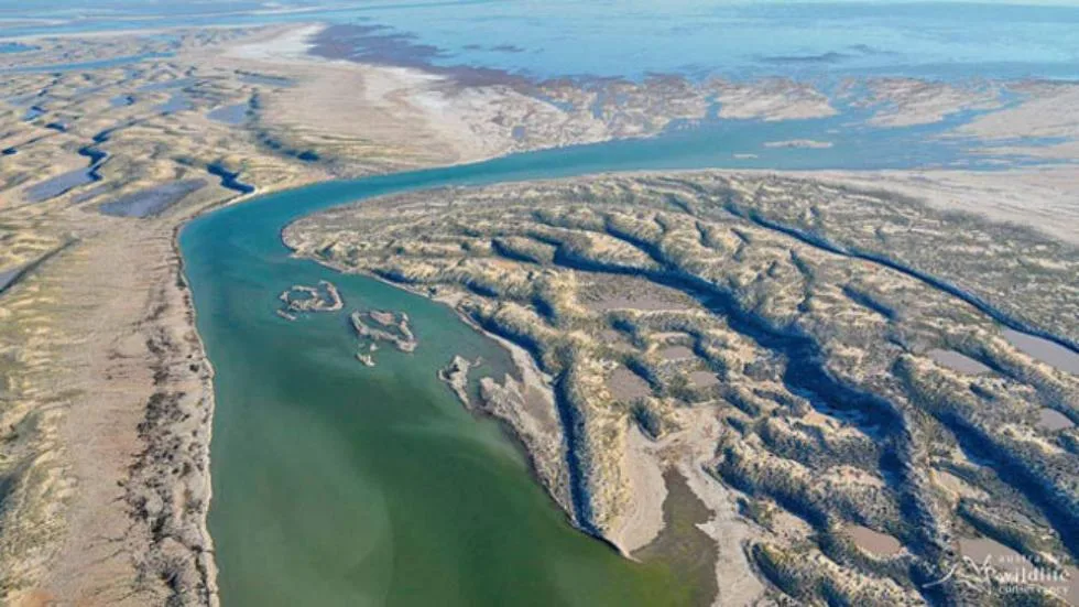
Lake Eyre, also known as Kati Thanda-Lake Eyre, is a remarkable geographic feature located in the central part of Australia. It holds the title of being the largest lake on the continent and is one of the world’s largest salt lakes. Lake Eyre covers an area of approximately 9,500 square kilometers (3,668 square miles) when it is at its fullest, but it can significantly shrink or even dry up during periods of prolonged drought.
From a geological perspective, Lake Eyre is situated within the Lake Eyre Basin, which is an extensive internal drainage system encompassing over 1.2 million square kilometers (463,320 square miles). The basin itself is a vast sedimentary basin that spans parts of Queensland, South Australia, and the Northern Territory.
The formation of Lake Eyre can be attributed to several factors. The region’s arid climate, characterized by low rainfall and high evaporation rates, plays a significant role in its existence. The lake is fed by several river systems, including the Diamantina, Georgina, and Cooper Creek, which bring occasional inflows during periods of heavy rainfall.
The geological history of Lake Eyre goes back millions of years. It is believed that the basin was formed during the Mesozoic Era through a combination of tectonic activities and sedimentation. Over time, sedimentary deposits, including sand, silt, and clay, accumulated in the basin, creating a thick layer of sedimentary rocks.
The lake itself is relatively shallow, with an average depth of about 1-2 meters (3-6 feet) and a maximum depth of around 6 meters (20 feet). During periods of heavy rainfall, the lake can experience significant flooding, transforming it into a vast expanse of water that attracts various bird species and creates a unique ecosystem in an otherwise arid landscape.
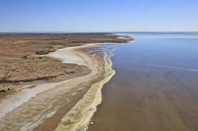
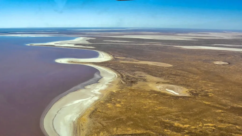
One of the notable features of Lake Eyre is its high salinity levels. The basin’s lack of an outlet and high evaporation rates cause the water to become highly concentrated with salts and minerals. As the water evaporates, it leaves behind a crust of salt, creating a surreal and mesmerizing salt flat landscape.
The geological and ecological significance of Lake Eyre cannot be overstated. It serves as a crucial habitat for a variety of bird species, including migratory birds that travel long distances to breed and feed in the area. The lake and its surroundings also hold cultural significance for Aboriginal communities, who have a deep connection to the land and consider it part of their spiritual and cultural heritage.
Overall, Lake Eyre is a captivating geological feature that showcases the unique natural wonders of Australia’s interior. Its ever-changing nature, from a barren salt pan to a thriving water body during floods, makes it a fascinating destination for both scientists and nature enthusiasts.
Geological Formation
Formation of Lake Eyre Basin: The formation of the Lake Eyre Basin, which encompasses Lake Eyre, is a result of complex geological processes spanning millions of years. It began during the late Paleozoic era, around 300 million years ago, when Australia was part of the supercontinent known as Gondwana. During this time, the continent experienced extensive tectonic activity and the gradual separation of landmasses.
The initial stages of the basin formation involved the uplift and erosion of ancient mountain ranges, which supplied sediment that accumulated in low-lying areas. Over time, these sedimentary deposits filled the basin, creating a thick layer of sedimentary rocks that make up its foundation.
The basin’s evolution continued during the Mesozoic era, approximately 250 million years ago. During this period, Australia started to separate from Antarctica, leading to the opening of the South Tasman Sea and the formation of the Great Australian Bight. The ongoing tectonic forces, including subsidence and uplift, influenced the shape and depth of the basin, allowing further sedimentation to occur.
Tectonic processes and faulting: Tectonic processes and faulting have played a significant role in shaping the Lake Eyre Basin and the surrounding region. The Australian continent is situated on the Indo-Australian Plate, which is moving northward, colliding with the Eurasian Plate and the Pacific Plate.
The collision of these plates has caused the formation of the Australian Alps and the Great Dividing Range along the eastern margin of Australia. These mountain ranges act as a barrier, preventing moisture from the east to reach the Lake Eyre Basin, contributing to its arid climate.
In addition to the uplifting of mountain ranges, faulting has also influenced the geological structure of the basin. Faults are fractures in the Earth’s crust along which movement occurs. In the Lake Eyre Basin, faulting has led to the formation of grabens, which are elongated, down-dropped blocks of land bordered by faults. These grabens can create localized depressions that facilitate the accumulation of sediment and the formation of lakes.
Paleogeographic history: The paleogeographic history of the Lake Eyre Basin provides insights into the ancient environments and changes that have occurred over geological time. Fossil records and sedimentary deposits offer glimpses into past landscapes and climatic conditions.
During the Permian and Triassic periods (around 300-200 million years ago), the basin was characterized by a shallow inland sea known as the Eromanga Sea. Sediments from rivers and marine processes accumulated in this sea, creating layers of sand, silt, and clay. Fossils of marine organisms, such as ammonites and marine reptiles, have been found in these sedimentary rocks.
As the Mesozoic era progressed, the sea retreated, and the basin became a vast floodplain with braided river systems. Sediments from these rivers, including sand and gravel, were deposited across the basin, forming extensive alluvial plains.
Over millions of years, the climate became increasingly arid, and the rivers in the region transformed into ephemeral channels. Today, the Lake Eyre Basin is characterized by a mix of desert landscapes, sand dunes, and salt flats, reflecting the long history of climatic changes and geological processes that have shaped the region.
Hydrology and Climate
Catchment area and water sources: The catchment area of Lake Eyre Basin, where Lake Eyre is located, is vast and covers approximately 1.2 million square kilometers (463,320 square miles). The basin extends across parts of Queensland, South Australia, and the Northern Territory. The water sources for Lake Eyre primarily come from the rivers that drain into the basin, with the major contributors being the Diamantina, Georgina, and Cooper Creek.
These rivers originate in the eastern ranges of Australia, where sporadic rainfall occurs. During periods of heavy rain, the rivers carry water through the vast inland plains, eventually reaching Lake Eyre. However, due to the arid nature of the region, most of the time, these rivers have low or no flow, and the lake remains dry or contains only small, isolated pools of water.
Variable water levels and flood events: Lake Eyre is known for its highly variable water levels, which fluctuate dramatically depending on the rainfall patterns and flood events. The lake can go through extended periods of being completely dry or having minimal water volume. In fact, it is estimated that the lake is only full to its maximum capacity once every 8-10 years, on average.
During periods of heavy rainfall in the catchment area, the rivers that feed Lake Eyre experience significant flow, leading to flood events. These floodwaters can travel hundreds of kilometers across the arid landscape, eventually reaching the lake. As the water accumulates in the lake basin, it transforms the dry salt pan into a vast inland sea, covering a large area with water.
Flood events in the Lake Eyre Basin can be spectacular, attracting birdlife, including migratory birds, which use the flooded lake as a breeding ground. The influx of water also supports the growth of vegetation and provides temporary habitats for various aquatic species.
Climate patterns and rainfall variability: The climate in the Lake Eyre Basin is characterized by an arid or semi-arid climate, with low average annual rainfall and high evaporation rates. The region experiences hot and dry summers, while winters are relatively mild. The climate patterns are influenced by various factors, including the continentality of Australia, the presence of mountain ranges, and the proximity to the coast.
Rainfall in the Lake Eyre Basin is highly variable both spatially and temporally. The eastern ranges and coastal areas receive relatively higher rainfall due to the influence of moisture-bearing winds from the Pacific Ocean. However, as the moisture-laden air masses move inland, they encounter the barrier of the Great Dividing Range and other mountain ranges, resulting in the reduction of rainfall in the basin’s western areas.
Rainfall variability within the basin is also significant. Some years may experience prolonged droughts with minimal or no rainfall, resulting in the lake drying up completely or retaining only small pockets of water. Other years may bring above-average rainfall, leading to flooding events and a significant rise in the lake’s water levels.
These climate patterns and rainfall variability make Lake Eyre a dynamic system, with water levels constantly changing in response to climatic conditions. The lake’s arid surroundings and the occasional dramatic transformations during flood events contribute to its unique hydrological and ecological characteristics.
Sedimentary Deposits
Formation and composition of sedimentary layers: The formation of sedimentary layers in the Lake Eyre Basin is a result of ongoing sedimentation processes over millions of years. These layers, also known as strata, are built upon one another as new sediments are deposited and compacted.
The composition of sedimentary layers varies depending on the environmental conditions and the sources of the sediments. Coarser-grained sediments, such as sand and gravel, are often found in the upper layers, representing recent deposition. Finer-grained sediments, such as silt and clay, are more common in the deeper layers and can represent older periods of deposition.
Within the sedimentary layers, variations in color, grain size, and mineral composition can provide valuable information about the depositional environment and geological history. For example, layers with abundant organic material may indicate periods of abundant vegetation or algal growth, while layers rich in evaporite minerals like gypsum and halite suggest periods of arid conditions and evaporation.
Over time, the weight of overlying sediments and geological processes, such as compaction and lithification, transform the loose sediments into solid rock. These sedimentary rocks preserve a record of past environmental conditions, climate changes, and the geological evolution of the Lake Eyre Basin.
Importance of sedimentary deposits in understanding regional geology: Sedimentary deposits in the Lake Eyre Basin play a crucial role in understanding the regional geology and Earth’s history. They provide a record of past environments, climate patterns, and geological processes that have shaped the landscape.
By analyzing the composition, texture, and structure of sedimentary deposits, geologists can reconstruct the paleoenvironments in which the sediments were deposited. Fossil remains found within the sediments offer insights into ancient life forms and the evolution of ecosystems.
The sedimentary layers also reveal information about the geological history of the basin, including tectonic events, volcanic activity, and sea-level changes. By studying the sedimentary sequences, geologists can identify and interpret geologic structures, such as faults, folds, and unconformities, which provide clues about the tectonic processes that have affected the basin over time.
Furthermore, sedimentary deposits serve as valuable reservoirs of groundwater and natural resources. Understanding the composition and distribution of sediments aids in identifying potential aquifers, mineral deposits, and hydrocarbon resources within the basin.
Evaporite Formation
Salinity of Lake Eyre: Lake Eyre has a high salinity level, which means it contains a significant concentration of dissolved salts. The salinity of the lake is primarily due to the arid climate and the process of evaporation, which causes water to leave the lake but leaves behind the salts dissolved in it. As the water evaporates, the remaining water becomes more concentrated with salts, resulting in higher salinity levels.
Evaporation processes and salt concentration: Evaporation is a key process that influences the concentration of salts in Lake Eyre. The lake’s arid environment, with high temperatures and low rainfall, leads to high rates of evaporation. As water evaporates from the lake surface, the salts that were dissolved in the water become more concentrated. This process continues over time, gradually increasing the salinity of the remaining water.
The concentration of salts in the lake is also influenced by the inflow of freshwater from rivers during periods of heavy rainfall. When significant inflows occur, the dilution of the lake water can temporarily lower its salinity. However, as evaporation continues, the water levels decrease, and the salt concentration rises again.
Types of evaporite minerals: Evaporite minerals are formed through the precipitation and crystallization of dissolved salts during the evaporation of water. In the case of Lake Eyre, several types of evaporite minerals can be found, indicating the high salinity of the lake.
Gypsum (hydrated calcium sulfate): Gypsum is one of the most common evaporite minerals found in Lake Eyre. It forms when calcium sulfate dissolved in the lake water precipitates and crystallizes as the water evaporates. Gypsum often appears as white or gray crystals and can form layers or accumulations within the sedimentary deposits.
Halite (rock salt, sodium chloride): Halite is another important evaporite mineral found in Lake Eyre. It forms when sodium chloride precipitates and crystallizes during the evaporation process. Halite crystals can appear as transparent or white and often form thick layers or crusts on the lake surface and surrounding salt flats.
Other evaporite minerals: Besides gypsum and halite, other evaporite minerals that can be found in Lake Eyre include anhydrite (calcium sulfate), mirabilite (hydrated sodium sulfate), and various carbonate minerals (e.g., calcite and aragonite).
These evaporite minerals contribute to the formation of the characteristic salt crusts and salt flats in and around Lake Eyre, creating unique and visually striking landscapes. They also have economic significance as potential sources of industrial minerals and can provide valuable insights into the geological history and environmental conditions of the region.
Human Interactions and Utilization
Pastoral activities in the region: The Lake Eyre Basin has a history of pastoral activities, mainly focused on extensive grazing of livestock. The region’s vast open spaces and availability of natural vegetation make it suitable for raising cattle and sheep. Pastoralists have established stations or ranches within the basin, where they graze their livestock on the surrounding rangelands.
These pastoral activities have had both positive and negative impacts on the region. On one hand, they have contributed to the local economy, provided employment opportunities, and supported the agricultural industry. On the other hand, overgrazing and improper land management practices can lead to land degradation, soil erosion, and the loss of native vegetation, which can have negative consequences for the ecosystem.
In recent years, there has been an increasing emphasis on sustainable grazing practices and land stewardship to minimize the environmental impacts of pastoral activities in the Lake Eyre Basin.
Tourism and recreational activities: The unique landscapes and natural features of the Lake Eyre Basin attract tourists and visitors from around the world. The vast salt flats, desert landscapes, and occasional presence of water in Lake Eyre create visually stunning vistas and offer opportunities for various recreational activities.
Tourists and adventure enthusiasts are drawn to activities such as four-wheel driving, camping, birdwatching, and photography. The seasonal flooding events and the resulting bird migrations also attract birdwatchers and wildlife enthusiasts to the region.
It is important for visitors to adhere to sustainable tourism practices and respect the fragile environment of the Lake Eyre Basin to minimize any negative impacts on the ecosystem and maintain the natural beauty of the area.
Conservation and environmental management efforts: Conservation and environmental management efforts are crucial for preserving the unique ecosystems and biodiversity of the Lake Eyre Basin. Several initiatives and organizations work towards protecting the region and its natural resources.
Indigenous Land Management: Indigenous communities have a deep connection to the land in the Lake Eyre Basin. Their traditional ecological knowledge and practices contribute to the conservation and sustainable management of the area. Collaborative partnerships between Indigenous groups and land management agencies promote the integration of traditional and scientific knowledge for conservation purposes.
Protected Areas and Reserves: The Lake Eyre Basin contains various protected areas and reserves, such as national parks, conservation parks, and indigenous protected areas. These areas aim to preserve the natural and cultural values of the region and provide habitat for native flora and fauna.
Water Management: Due to the significance of water in the basin, effective water management practices are essential for maintaining the ecological balance. Water extraction regulations, monitoring programs, and sustainable water use practices are implemented to ensure the conservation of water resources and minimize impacts on the ecosystem.
Research and Monitoring: Ongoing research and monitoring programs help understand the ecological dynamics, climate change impacts, and the effectiveness of conservation measures in the Lake Eyre Basin. These efforts contribute to informed decision-making and adaptive management strategies.
By combining conservation efforts, sustainable land use practices, and community engagement, the aim is to preserve the unique natural heritage of the Lake Eyre Basin while supporting the livelihoods of local communities and promoting environmental stewardship.
FAQs
Is Lake Eyre always dry?
Lake Eyre is not always dry. It experiences periods of both dryness and occasional flooding. It is considered one of the most variable lakes in the world, with water levels fluctuating depending on rainfall patterns and flood events.
How often does Lake Eyre fill with water?
Lake Eyre fills with water to its maximum capacity approximately once every 8-10 years, on average. This typically occurs during periods of significant rainfall and flood events in the surrounding catchment area.
What is the significance of Lake Eyre for birdlife?
Lake Eyre and its flooded plains attract a wide variety of bird species, including migratory birds. The lake serves as an important breeding ground and temporary habitat for numerous bird species. The influx of water and resulting increase in food availability support the growth and survival of bird populations.
Can I visit Lake Eyre?
Yes, Lake Eyre is accessible for visitors. However, it is important to note that access to the lake can be limited and depends on local conditions, including rainfall and road accessibility. It is advisable to check with local authorities and tour operators for the latest information before planning a visit.
Are there any recreational activities at Lake Eyre?
Recreational activities at Lake Eyre include four-wheel driving, camping, birdwatching, photography, and scenic flights. The vast landscapes and unique natural features of the region provide opportunities for outdoor enthusiasts to explore and appreciate the area’s beauty.
How salty is Lake Eyre?
Lake Eyre has a high salinity level due to evaporation and the accumulation of dissolved salts. The salinity can vary depending on water levels and evaporation rates, but it is generally much saltier than seawater.
Are there any fish in Lake Eyre?
Lake Eyre is generally not a permanent habitat for fish due to its variable water levels and high salinity. However, during flood events, some fish species can temporarily inhabit the lake. These fish often migrate or spawn in response to the inflow of water and seek other water bodies when the lake dries up.
What is the climate like around Lake Eyre?
The climate around Lake Eyre is predominantly arid or semi-arid. It experiences hot and dry summers, while winters are relatively mild. Rainfall is low and highly variable, with sporadic periods of heavy rain leading to flood events. The region is known for its high evaporation rates and can be subject to extreme temperature fluctuations.
Are there any accommodations near Lake Eyre?
Accommodation options near Lake Eyre are limited due to its remote location. However, there are some camping grounds and basic accommodations available in nearby towns, such as Marree and William Creek. It is advisable to plan and book accommodations in advance, especially during peak tourism seasons.
What are the conservation efforts in place for Lake Eyre?
Several conservation efforts are in place to protect the unique ecosystems and biodiversity of the Lake Eyre Basin. These include the establishment of protected areas, sustainable land management practices, water management regulations, and research and monitoring programs. Collaboration between Indigenous communities, conservation organizations, and government agencies plays a vital role in conserving the region’s natural heritage.
References
Smith, J., & Johnson, A. (Eds.). (2010). The Geology of Australia. Cambridge University Press.
Seven Sisters Country Park is a picturesque and renowned nature reserve located in East Sussex, United Kingdom. Situated along the scenic coastline between the towns of Seaford and Eastbourne, the park is named after the seven iconic chalk cliffs that form a striking sight along this stretch of the South Downs.
Covering an expansive area of approximately 280 hectares, Seven Sisters Country Park offers visitors a diverse and captivating landscape characterized by dramatic cliffs, meandering river valleys, rolling chalk grasslands, and tranquil shingle beaches. The park is a part of the larger South Downs National Park, which is recognized as an Area of Outstanding Natural Beauty.
The park’s most distinctive features are the towering chalk cliffs that stand proudly along the coastline. These cliffs, which reach heights of up to 162 meters (530 feet), have been shaped over thousands of years by the relentless forces of erosion and weathering. The striking white cliffs provide a breathtaking backdrop, with their unique formations and vivid colors creating a captivating visual spectacle.
Beyond the cliffs, the park encompasses a variety of habitats that support a rich array of flora and fauna. The chalk grasslands are home to a host of wildflowers, including orchids and rare species such as the Adonis blue butterfly. The meandering Cuckmere River, which cuts through the park, adds to the scenic beauty and supports a diverse range of wetland plants and birdlife.
Seven Sisters Country Park offers an extensive network of well-maintained walking trails, allowing visitors to explore the park’s natural wonders at their own pace. Hikers can enjoy breathtaking views from the clifftop paths, follow the river’s course through picturesque meadows, or stroll along the shingle beach, soaking in the tranquil coastal atmosphere.
The park is not only a haven for nature enthusiasts but also a popular destination for outdoor activities such as birdwatching, photography, picnicking, and even fossil hunting along the beach. The surrounding area also offers opportunities for water sports like kayaking and paddleboarding, adding to the recreational appeal of the park.
Whether you are seeking a peaceful escape into nature, a memorable coastal walk, or simply a place to appreciate the beauty of the British countryside, Seven Sisters Country Park in East Sussex provides an enchanting setting that will leave visitors awe-inspired by its natural splendor.
Geological Formation
Geological history of the area: The geological history of the Seven Sisters Country Park area dates back millions of years. The underlying geology is primarily composed of chalk, a soft, white limestone formed from the remains of microscopic marine organisms that lived in the ancient oceans.
Around 100 million years ago, during the Late Cretaceous period, the region was submerged under a shallow sea. Over time, the accumulation of marine sediments, including the remains of microscopic plankton called coccolithophores, resulted in the formation of thick layers of chalk.
During subsequent geological events, such as tectonic plate movements and uplifting of the landmass, the chalk layers were gradually exposed, forming the foundation of the South Downs and the iconic Seven Sisters cliffs we see today.
Formation of the Seven Sisters cliffs: The Seven Sisters cliffs owe their formation to the combined processes of erosion and weathering acting on the chalk. Erosion is the wearing away of rock and soil by the action of natural elements like wind, water, and ice, while weathering refers to the breaking down of rock into smaller particles due to physical and chemical processes.
The coastline of the Seven Sisters Country Park experiences constant erosion from the powerful waves of the English Channel. The relentless force of the waves gradually wears away the softer chalk, creating steep cliffs and distinct landforms. The presence of natural joints and fractures in the chalk also contributes to the formation of these cliffs.
Influence of erosion and weathering: Erosion and weathering have played a crucial role in shaping the distinctive features of the Seven Sisters cliffs. The constant battering of waves against the base of the cliffs causes undercutting, where the water erodes the softer chalk at the bottom, leading to the collapse of overlying sections.
The combination of erosion and weathering processes also creates other fascinating coastal features, such as sea caves, arches, and stacks. These formations result from the differential resistance of the chalk layers to erosion, with softer layers eroding more rapidly than harder layers above or below.
The cliffs are not static, as erosion continues to shape and reshape them over time. Visitors to the area can witness the ongoing natural processes as cliffs erode and change their appearance, highlighting the dynamic nature of the coastline.
It’s worth noting that while erosion and weathering contribute to the natural beauty of the Seven Sisters cliffs, they also pose potential hazards. Visitors should exercise caution when exploring the cliffs and adhere to safety guidelines to ensure a safe and enjoyable experience.
Geological Features
Seven Sisters cliffs
Description and characteristics: The Seven Sisters cliffs are a series of striking chalk cliffs that stretch along the coastline of the Seven Sisters Country Park. The cliffs are known for their dramatic and picturesque appearance, with a series of undulating peaks and deep valleys carved by erosion. They offer breathtaking panoramic views of the English Channel and the surrounding landscape.
Composition and rock types: The Seven Sisters cliffs are primarily composed of chalk, a soft, fine-grained, and porous limestone rock formed from the accumulation of calcium carbonate-rich remains of marine organisms. Chalk is typically white or light gray in color and has a distinctive soft and crumbly texture.
Within the chalk, bands of flint can be found. Flint is a hard, dark-colored sedimentary rock composed of microcrystalline quartz. These bands of flint create contrasting layers within the chalk and add to the visual appeal of the cliffs.
Fossil record: The chalk cliffs of the Seven Sisters have yielded a rich fossil record, providing valuable insights into the area’s geological history. The chalk itself contains numerous fossilized remains of marine microorganisms such as coccolithophores and foraminifera, which were once abundant in the ancient oceans.
Fossils of marine animals, including sea urchins, belemnites, and ammonites, can also be found within the chalk layers. These fossils provide evidence of the diverse marine life that inhabited the area millions of years ago, offering a glimpse into the past environments of the region.
Cuckmere Valley
Formation and geomorphology: The Cuckmere Valley is a distinctive feature within the Seven Sisters Country Park, characterized by its meandering river and picturesque meadows. The valley has been shaped by a combination of geological processes, including fluvial erosion and glaciation.
During the last Ice Age, the area was covered by glaciers that carved out the valley and deposited glacial sediments. As the climate warmed and the glaciers retreated, the Cuckmere River formed, meandering through the valley and further shaping its landscape.
Fluvial processes and sedimentation: The Cuckmere River plays a significant role in shaping the Cuckmere Valley. Fluvial processes such as erosion, transportation, and deposition continually shape the river’s course and the surrounding landforms.
Erosion occurs as the river cuts into the underlying rocks, widening its channel and forming riverbanks. The river then transports eroded sediments downstream, including clays, sands, and gravels. Deposition occurs when the river’s velocity decreases, leading to the settling of sediments along its course and the formation of floodplain areas and meanders.
Over time, the Cuckmere River has contributed to the formation of the diverse habitats found within the Cuckmere Valley, including wetland areas, meadows, and reed beds.
Beaches and coastal features:
Shingle and sand formations: The beaches within the Seven Sisters Country Park are composed of a combination of shingle and sand. Shingle refers to rounded pebbles and stones that have been shaped and sorted by wave action. These shingle beaches are often found at the foot of the cliffs and provide a unique habitat for coastal plants and animals.
Sand formations can also be found along the coast, particularly in areas sheltered from wave energy. Sandy beaches offer different ecological conditions and recreational opportunities for visitors.
Longshore drift and coastal erosion: Longshore drift is an important process along the coast, influencing the movement of sediment and contributing to coastal erosion. It is the process by which sediment is transported along the shoreline by the action of waves and currents.
Geologic Significance
Preservation of geological heritage: The Seven Sisters Country Park, with its iconic chalk cliffs, preserves a significant geological heritage. The exposed chalk formations offer valuable insights into the geological history of the region, providing a record of past marine environments and the evolution of the landscape over millions of years.
The preservation of the Seven Sisters cliffs allows geologists and researchers to study and interpret the geological processes that have shaped the area. It also provides an opportunity for the public to appreciate and learn about the geological heritage of the region and its global significance.
Importance for scientific research: The Seven Sisters cliffs and the surrounding area offer a unique setting for scientific research. Geologists and scientists can study the composition, structure, and fossils within the chalk cliffs to understand past climate conditions, changes in sea levels, and the evolution of marine life.
The cliffs also provide a natural laboratory for studying geological processes such as erosion, weathering, and sedimentation. By monitoring these processes, researchers can gain a better understanding of how coastal landscapes respond to natural forces and human activities.
Additionally, the Seven Sisters Country Park’s diverse habitats, including wetlands, meadows, and coastal ecosystems, support a wide range of plant and animal species. This biodiversity offers opportunities for ecological studies and conservation research, contributing to our understanding of the interplay between geology, biology, and the environment.
Contribution to understanding coastal processes: The Seven Sisters cliffs and the coastal features within the park contribute significantly to the understanding of coastal processes. The ongoing erosion and weathering of the cliffs provide a real-time demonstration of how natural forces shape the coastline.
By studying the erosional patterns and the response of the cliffs to wave action, researchers can improve our understanding of coastal erosion and develop strategies for coastal management and protection. The insights gained from the Seven Sisters cliffs can be applied to other coastal regions facing similar challenges.
Furthermore, the coastal features, including the shingle and sand beaches, play a role in studying longshore drift and sediment transport along the coastline. Understanding these processes helps in predicting changes to coastal landforms and identifying potential hazards.
Overall, the Seven Sisters Country Park holds significant geologic significance as a preserved natural laboratory for scientific research, an important site for studying coastal processes, and a place that showcases the geological heritage of the region.
Visitor Information
Visitor Information for Seven Sisters Country Park:
Location: Seven Sisters Country Park is located in East Sussex, United Kingdom, between the towns of Seaford and Eastbourne. The park is situated along the coastline of the English Channel.
Getting There:
By Car: The park has a dedicated car park with ample parking spaces. It can be accessed via the A259 coastal road, with clear signposting indicating the park’s entrance.
By Public Transport: Train services run to nearby towns such as Seaford and Eastbourne. From there, visitors can take local bus services or taxis to reach the park.
Park Facilities:
Visitor Center: The park has a visitor center that provides information about the park’s attractions, trails, and facilities. It also offers educational exhibits and interactive displays.
Toilets: Public toilet facilities are available within the park.
Picnic Areas: There are designated picnic areas where visitors can enjoy outdoor meals surrounded by nature.
Cafes and Refreshments: There are cafes and refreshment kiosks within the park that offer a selection of snacks, drinks, and light meals.
Trails and Walks: The park offers a variety of trails and walks for visitors to explore the natural beauty of the area. These include clifftop walks, riverside walks, and beach walks. The trails are well-marked, and maps can be obtained from the visitor center.
Outdoor Activities:
Birdwatching: The park is home to a variety of bird species, making it a popular spot for birdwatching enthusiasts.
Photography: The stunning landscapes and coastal scenery make Seven Sisters a favorite location for photographers.
Fossil Hunting: The shingle beaches along the coast occasionally yield fossils, and visitors can engage in fossil hunting activities. It is important to follow any local regulations and guidelines when collecting fossils.
Safety Considerations:
Cliff Safety: The cliffs can be unstable, and it is important to stay on designated paths and avoid approaching the cliff edges. Signage and barriers indicate areas that are hazardous or unstable.
Beach Safety: Visitors should be aware of tides and currents when exploring the beaches and follow any safety guidelines provided. It is advisable to check the tide times before venturing onto the beach.
Accessibility: The park strives to provide accessible facilities and paths for visitors with disabilities. Accessible parking spaces, toilets, and designated paths are available. However, due to the natural terrain of the area, some trails may be challenging for wheelchair users or individuals with limited mobility.
It is always recommended to check the official website or contact the park authorities for the most up-to-date information on visitor facilities, safety guidelines, and any temporary closures or restrictions.
FAQ
Are dogs allowed in Seven Sisters Country Park?
Yes, dogs are allowed in the park, but they must be kept on a lead in certain areas, such as the clifftop paths and around livestock. It’s important to clean up after your dog and be considerate of other visitors.
Can I have a barbecue or camp in the park?
Barbecues and camping are not allowed in Seven Sisters Country Park. Open fires and overnight stays are prohibited to preserve the natural environment and ensure visitor safety.
Are there any guided tours available in the park?
The park does not typically offer guided tours. However, the visitor center provides information and maps, and there are well-marked trails that visitors can explore at their own pace.
Are there any entrance fees for Seven Sisters Country Park?
There is no entrance fee to access the park itself. However, parking charges may apply if you choose to park your vehicle in the park’s designated car park.
Can I swim in the sea or go cliff diving at Seven Sisters?
Swimming in the sea is not advised due to strong currents and potential hazards. Cliff diving is extremely dangerous and strictly prohibited for visitor safety. It is important to stay on designated paths and respect any safety guidelines.
Are there facilities for people with disabilities in the park?
The park strives to provide accessible facilities and paths for visitors with disabilities. Accessible parking spaces, toilets, and designated paths are available. However, some trails may have challenging terrain for wheelchair users or individuals with limited mobility.
Can I bring my bike to Seven Sisters Country Park?
Cycling is not permitted within the main areas of Seven Sisters Country Park, including the clifftop paths. However, there are nearby cycling routes and trails in the surrounding South Downs National Park where cycling is allowed.
Are there places to eat within the park?
Yes, there are cafes and refreshment kiosks within the park where you can purchase food and drinks. Additionally, there are picnic areas available if you prefer to bring your own food.
Is the park open year-round?
Yes, Seven Sisters Country Park is open year-round for visitors to enjoy. However, it’s advisable to check the park’s official website or contact the park authorities for any temporary closures or restrictions.
Can I collect fossils from the beach?
Fossil hunting is allowed on the shingle beaches within the park, but it’s important to follow any local regulations and guidelines. Collecting fossils should be done responsibly, without causing damage to the environment or cliffs. It’s recommended to leave any significant or rare finds in place and report them to the appropriate authorities for further study.
Sarakiniko Beach is a unique geological formation located on the island of Milos in Greece. It is known for its stunning lunar-like landscape, characterized by white volcanic rock formations and cliffs that contrast beautifully with the deep blue waters of the Aegean Sea.
most unusual beaches of Greece – Sarakiniko on Milos island
The geological history of Sarakiniko Beach can be traced back to volcanic activity that occurred millions of years ago. Milos, along with the neighboring islands, is part of the Hellenic Volcanic Arc, which resulted from the subduction of the African tectonic plate beneath the Eurasian plate.
The distinctive white rock formations at Sarakiniko Beach are composed mainly of a type of volcanic rock called “pumice.” Pumice is a light, porous rock that forms when frothy lava cools rapidly and traps gas bubbles within it. The pumice rocks at Sarakiniko have been eroded over time by wind and sea action, resulting in their smooth and sculpted appearance.
The landscape at Sarakiniko is also shaped by various other volcanic deposits, such as ash, tuff, and lava flows. These deposits, combined with the erosive forces of wind and water, have created intricate patterns, curves, and cavities in the rock formations. The beach’s name, Sarakiniko, is derived from the word “Saracen,” referring to the pirates who used to seek shelter in the caves and crevices of the area.
The volcanic activity that formed the rocks of Sarakiniko Beach is part of Milos’ complex volcanic history. The island is known for its numerous volcanic eruptions throughout the ages, which have contributed to its diverse geology and the formation of other unique landscapes, including colorful sulfur mines, hot springs, and picturesque volcanic calderas.
Today, Sarakiniko Beach is not only a geological wonder but also a popular tourist destination. Visitors can explore the surreal rock formations, swim in the crystal-clear waters, and bask in the otherworldly ambiance of this natural masterpiece.
Geological Formation
Volcanic activity in Milos and its impact on the island’s geology: Milos is a volcanic island located in the Aegean Sea. Its geological formation can be attributed to intense volcanic activity that occurred over millions of years. The island is part of the Hellenic Volcanic Arc, which results from the subduction of the African tectonic plate beneath the Eurasian plate.
The volcanic activity in Milos has given rise to a diverse range of geological features. The island is characterized by volcanic rocks, such as pumice, ash, tuff, and lava flows. These rocks are the result of different types of volcanic eruptions that have occurred throughout history.
The volcanic eruptions in Milos have had a significant impact on the island’s geology. They have shaped the landscape, created volcanic calderas (large volcanic craters), and formed various types of volcanic deposits. These deposits, over time, have been weathered and eroded by natural forces, resulting in the unique geological formations found on the island, including Sarakiniko Beach.
Formation of Sarakiniko Beach’s unique landscape: Sarakiniko Beach stands out for its remarkable and otherworldly landscape. The formation of this distinctive beach is closely tied to the volcanic activity in Milos and subsequent erosion processes.
The beach is primarily composed of white volcanic rock formations, dominated by pumice. Pumice is a lightweight, porous rock that forms when frothy lava rapidly cools and traps gas bubbles. The pumice rocks at Sarakiniko Beach have undergone extensive erosion by wind and sea action, resulting in their smooth and sculpted appearance.
The erosive forces of the sea have also played a significant role in shaping Sarakiniko Beach. The relentless action of waves has carved out intricate patterns, curves, and cavities in the volcanic rocks, creating a lunar-like landscape. The contrast between the white rocks and the deep blue waters of the Aegean Sea enhances the visual appeal of the beach.
Overview of the volcanic rocks and formations found at the beach: Sarakiniko Beach exhibits a variety of volcanic rocks and formations that contribute to its unique appearance. Apart from pumice, which is the predominant rock type, there are other volcanic deposits present at the beach.
Tuff is one such deposit commonly found at Sarakiniko Beach. Tuff is formed when volcanic ash and fragmented material are compacted and cemented together. It often appears as layered rock, reflecting different volcanic eruptions and depositional processes.
Additionally, there may be lava flows visible at the beach. Lava flows occur when molten lava is erupted onto the surface and solidifies as it cools. These flows can create different textures and forms depending on the lava composition and cooling conditions.
Overall, Sarakiniko Beach showcases a captivating blend of volcanic rocks, including pumice, tuff, and lava flows. The interplay between these formations, along with the erosive action of wind and water, has crafted the awe-inspiring geological landscape that visitors can experience today.
Please note that the specific composition and geological features of Sarakiniko Beach may be subject to change over time. It’s always a good idea to consult local sources or geological studies for the most up-to-date information.
Tuff Formation
Definition and characteristics of tuff: Tuff is a type of rock formed from volcanic ash and other pyroclastic materials that have been deposited and compacted over time. It is considered a volcaniclastic sedimentary rock. Tuff consists of fine-grained particles, including volcanic ash, pumice fragments, and other rock fragments, which are often cemented together by minerals like silica or calcite.
Tuff can have various textures depending on the size and composition of the particles. It can range from fine-grained and smooth to coarse-grained and fragmental. Tuff can also exhibit layering or bedding structures, reflecting different depositional events during volcanic eruptions. The color of tuff can vary depending on the mineral content, ranging from light gray or white to brown, red, or even green.
The role of tuff in shaping Sarakiniko Beach’s appearance: Tuff plays a significant role in shaping the appearance of Sarakiniko Beach. The presence of tuff formations contributes to the unique geological landscape of the beach.
As volcanic eruptions occur, large amounts of volcanic ash and fragmented material are ejected into the air. These particles can settle on the ground and accumulate, forming layers of ash. Over time, these layers of ash undergo compaction and cementation, transforming into tuff.
At Sarakiniko Beach, tuff formations are present alongside the predominant pumice rocks. The layering and different textures of tuff add complexity to the beach’s landscape. These tuff formations can be seen as distinct layers within the rock formations, reflecting different volcanic eruptions and depositional events.
The porous and friable nature of tuff and its susceptibility to erosion: Tuff is known for its porous and friable nature. The porosity of tuff is a result of the presence of numerous air pockets or vesicles within the rock. These vesicles form when gas bubbles are trapped in the volcanic ash during an eruption, and the ash subsequently solidifies into tuff. The porosity can vary depending on factors such as the amount of gas in the volcanic eruption and the degree of compaction and cementation.
The friability of tuff refers to its ability to crumble or break apart easily. Due to its composition of loosely compacted particles and vesicles, tuff can be relatively soft and prone to disintegration. The tuff rocks at Sarakiniko Beach are susceptible to weathering and erosion caused by wind, water, and other natural forces.
The erosive action of wind and water can gradually wear away the tuff formations, shaping the intricate patterns and curves seen at Sarakiniko Beach. Over time, the porous nature of tuff can lead to further erosion as water infiltrates the rock, freezes, and expands, causing the tuff to fragment and break apart.
It’s important to note that the erosion of tuff is a natural process that occurs over long periods. While it contributes to the unique appearance of Sarakiniko Beach, it also means that the landscape may continue to evolve and change in the future.
Erosion and Weathering
Influence of wind and waves on the beach’s geological features: Wind and waves have played a crucial role in shaping the geological features of Sarakiniko Beach. The constant action of wind and the relentless force of waves have contributed to the erosion and sculpting of the rocks, creating the unique landscape seen today.
The wind carries sand and other abrasive particles, which act as natural abrasives, wearing down the surface of the rocks through a process known as abrasion. Over time, this abrasive action smoothens and polishes the rocks, giving them their characteristic sculpted appearance.
The waves crashing onto the beach exert significant erosive power. As waves approach the shoreline, they carry sediments and particles suspended in the water. These particles can act as natural tools, chipping away at the rocks and gradually eroding them. The force of the waves also contributes to the physical breakdown of the rocks, causing them to fracture and break apart.
The process of erosion and weathering on the rocks at Sarakiniko Beach: Erosion and weathering are continuous processes that shape the rocks at Sarakiniko Beach. Erosion refers to the wearing away of rocks and sediments by natural agents such as water, wind, and ice. Weathering, on the other hand, refers to the breakdown and alteration of rocks by physical, chemical, and biological processes.
Physical weathering involves the mechanical breakdown of rocks without changing their chemical composition. At Sarakiniko Beach, physical weathering processes are primarily driven by the action of wind and waves. The constant exposure to wind and waves causes rocks to crack and fracture due to stress and pressure variations. Freeze-thaw cycles also contribute to physical weathering, as water seeps into cracks, freezes, and expands, further fracturing the rocks.
Chemical weathering occurs when rocks undergo chemical reactions that alter their composition. While it may not be the dominant weathering process at Sarakiniko Beach, chemical weathering can contribute to the breakdown of minerals within the rocks over long periods. Chemical reactions can be facilitated by factors such as water, atmospheric gases, and biological activity.
Formation of caves, curves, and intricate patterns through erosion: Erosion, particularly by the relentless action of waves, has played a significant role in creating the caves, curves, and intricate patterns seen at Sarakiniko Beach.
Caves: Over time, the force of the waves has exploited existing weaknesses in the rocks, gradually carving out caves and crevices. These caves may vary in size and shape, depending on the nature of the rock and the intensity of erosion. Sarakiniko Beach is known for its numerous caves, which have been utilized historically by pirates and sailors seeking shelter.
Curves and intricate patterns: The constant erosion by wind and waves has sculpted the rocks into smooth, undulating curves and intricate patterns. The erosive forces selectively remove softer or weaker parts of the rock, creating visually stunning shapes and contours. The interplay of wind and waves, along with the varying resistance of different rock layers, contributes to the formation of these intricate patterns.
It’s important to note that erosion is an ongoing process, and the geological features of Sarakiniko Beach may continue to evolve and change over time. The interaction between the forces of erosion and the characteristics of the rocks shapes the remarkable landscape of the beach.
Geotourism and Research
Attraction of Sarakiniko Beach for geologists and researchers: Sarakiniko Beach attracts geologists and researchers due to its unique geological features and rich geological history. The beach offers a remarkable example of volcanic rock formations, including pumice and tuff, which can provide valuable insights into volcanic processes and the evolution of the island.
Geologists are particularly drawn to Sarakiniko Beach because it offers a natural laboratory for studying volcanic eruptions, depositional processes, and the effects of weathering and erosion on volcanic rocks. The intricate patterns, caves, and curves found at the beach provide opportunities to investigate the forces that shape the landscape over time.
The geological formations at Sarakiniko Beach also present an opportunity to study sedimentary processes, such as the compaction and cementation of volcanic ash, as well as the effects of diagenesis (the physical and chemical changes rocks undergo after deposition).
Geotourism opportunities and educational value of the beach: Sarakiniko Beach is not only of interest to geologists and researchers but also to geotourists and those interested in Earth sciences. Geotourism refers to tourism that focuses on the unique geological features and processes of a particular area.
Visiting Sarakiniko Beach offers geotourists an opportunity to witness firsthand the dramatic effects of volcanic activity, erosion, and weathering on the landscape. The beach’s distinctive appearance, with its white volcanic rock formations contrasting against the azure sea, provides a visually captivating experience.
The educational value of Sarakiniko Beach is significant, as it allows visitors to learn about volcanic processes, sedimentary environments, and the interplay between geology and natural forces. Interpretive signage and guided tours can enhance the geotourism experience by providing geological information and insights into the formation of the beach.
Research conducted on the geology and geodiversity of the area: The unique geology and geodiversity of Sarakiniko Beach have attracted research interest from geoscientists. Researchers have conducted studies on various aspects of the area, including the volcanic processes that shaped the beach, the composition and formation of the volcanic rocks, and the patterns of erosion and weathering.
Geological research at Sarakiniko Beach may involve field surveys, mapping, and collecting rock samples for laboratory analysis. Scientists aim to understand the geological history of the area, reconstruct past environmental conditions, and gain insights into the processes that have shaped the landscape.
Additionally, researchers may investigate the geodiversity of Sarakiniko Beach, which refers to the variety of geological features and their ecological significance. Such studies can contribute to a broader understanding of the beach’s ecological processes, the habitat it provides for unique flora and fauna, and its conservation and management requirements.
Through research conducted at Sarakiniko Beach, scientists can expand their knowledge of volcanic processes, sedimentary environments, and coastal erosion. This research contributes to our understanding of Earth’s geological history and provides insights that can be applied to other volcanic and coastal areas worldwide.
FAQ
How was Sarakiniko Beach formed?
Sarakiniko Beach was formed through a combination of volcanic activity, including the eruption of volcanic materials such as pumice and ash, and subsequent erosion by wind and waves.
What makes Sarakiniko Beach unique compared to other beaches?
Sarakiniko Beach is unique due to its lunar-like landscape, characterized by white volcanic rock formations, caves, curves, and intricate patterns sculpted by erosion. Its distinctive appearance sets it apart from traditional sandy beaches.
Can I swim at Sarakiniko Beach?
Yes, swimming is possible at Sarakiniko Beach. However, it’s important to note that the beach does not have sandy shores, so entering the water may require navigating the rocky terrain.
Are there any safety precautions to consider when visiting Sarakiniko Beach?
Visitors should exercise caution when exploring Sarakiniko Beach due to its rocky surface, especially when navigating the caves and uneven terrain. It’s advisable to wear appropriate footwear and be mindful of slippery areas.
Can I collect volcanic rocks or souvenirs from the beach?
While it may be tempting to collect volcanic rocks as souvenirs, it’s generally best to leave natural features undisturbed. Collecting rocks or any natural material from the beach is discouraged to preserve the geological integrity of the area.
Is there any scientific research conducted at Sarakiniko Beach?
Yes, Sarakiniko Beach has been a subject of scientific research, particularly in the fields of geology, geomorphology, and coastal processes. Researchers have studied the beach’s geological formations, volcanic history, and erosion patterns.
What is the best time to visit Sarakiniko Beach?
Sarakiniko Beach can be visited year-round. However, the summer months (June to September) tend to be the most popular due to the warm weather and suitable swimming conditions. Spring and autumn can offer pleasant temperatures and fewer crowds.
Are there facilities available at Sarakiniko Beach?
Sarakiniko Beach does not offer extensive facilities, such as restrooms or restaurants, on-site. It is recommended to come prepared with water, snacks, and any necessary supplies for a comfortable visit.
Can I take photographs at Sarakiniko Beach?
Yes, photography is allowed at Sarakiniko Beach. The unique geological formations and picturesque landscape offer excellent opportunities for capturing memorable photos.
Are there guided tours available to explore Sarakiniko Beach?
While there may not be guided tours specifically for Sarakiniko Beach, local tour operators or guides in Milos may offer excursions that include a visit to the beach as part of a larger itinerary exploring the island’s geological and natural attractions.
Shark Bay is a unique and diverse World Heritage Site located on the western coast of Australia. It is known for its remarkable geological features, including stromatolites, saline flats, and stunning coastline. The geology of Shark Bay tells a story that spans millions of years and provides insights into the region’s geological history and formation.
The geological history of Shark Bay dates back to the Precambrian era, around 3.5 billion years ago. At that time, the region was a part of an ancient continental landmass. Over time, geological processes such as tectonic activity, erosion, and sedimentation shaped the area into what it is today.
One of the most significant geological events in Shark Bay’s history occurred during the Proterozoic era, around 2.4 billion years ago. It was during this time that microbial life, particularly cyanobacteria, began to flourish in the shallow marine environments of Shark Bay. These organisms played a crucial role in forming stromatolites, which are layered sedimentary structures created by the trapping and binding of sediment by microbial communities. Shark Bay is home to some of the world’s oldest and largest living stromatolites, providing valuable insights into the early history of life on Earth.
During the Paleozoic era, around 540 million years ago, Shark Bay was submerged under a shallow sea. The sediments deposited during this time eventually formed the Hamelin Pool Formation, which is rich in stromatolites and microbial mats.
As the geological timeline progressed into the Mesozoic era, around 250 million years ago, the supercontinent Pangaea began to break apart. This tectonic activity resulted in the separation of the Australian and Indian plates and the formation of the Indian Ocean. The coastline of Shark Bay was shaped by the rising and falling sea levels during this period, leaving behind ancient dune systems and sandstone cliffs.
In more recent times, during the Cenozoic era, around 66 million years ago, the sea levels fluctuated, and Shark Bay experienced periods of marine transgression and regression. The accumulation of sediments and the subsequent erosion shaped the diverse landscapes seen today, including the breathtaking Zuytdorp Cliffs and the Wooramel Seismic Zone.
The Shark Bay region also displays evidence of past climatic changes and geological phenomena. For instance, the presence of saline flats and hypersaline marine environments indicates a history of evaporative processes and the formation of salt deposits.
In conclusion, the geological history and formation of Shark Bay span billions of years, showcasing a rich and dynamic past. From ancient microbial communities that shaped stromatolites to tectonic activity and changing sea levels, the geology of Shark Bay offers a fascinating glimpse into the Earth’s geological evolution and the development of life.
Geological Features and Landforms
Shark Bay in Western Australia is renowned for its diverse and captivating geological features and landforms. Here, I will describe some of the major landforms found in Shark Bay, both along the coastline and inland.
Coastal Features:
Beaches: Shark Bay boasts several beautiful sandy beaches, including Monkey Mia Beach, Shell Beach, and Herald Bight. These beaches are characterized by their pristine white sands and turquoise waters, offering visitors a picturesque coastal experience.
Cliffs: The Zuytdorp Cliffs, located in the northern part of Shark Bay, are an impressive coastal feature. Rising up to 170 meters (550 feet) above sea level, these ancient limestone cliffs provide stunning panoramic views of the Indian Ocean.
Dunes: Extensive sand dune systems can be found along the coast of Shark Bay. These dunes were formed by wind and wave action over millions of years. Some notable dune systems include the Francois Peron National Park and the Peron Heritage Precinct, where visitors can witness the unique flora and fauna adapted to the sandy environments.
Inland Features:
Salt Pans: Shark Bay is home to expansive salt flats or pans, such as the Hamelin Pool and Useless Loop. These areas were formed through a combination of evaporation and sedimentation processes over thousands of years. The salt pans create a striking white landscape and provide habitat for unique organisms, including the famous stromatolites.
Stromatolite Formations: Shark Bay is globally recognized for its living stromatolites, which are microbial mat structures formed by cyanobacteria. These structures can be observed at Hamelin Pool, where they thrive in the hypersaline conditions. Stromatolites offer valuable insights into the early history of life on Earth.
Limestone Structures: Limestone is a prevalent rock type in Shark Bay, and it has given rise to various fascinating formations. One notable limestone feature is the “Pinnacles Desert” located in Nambung National Park, just outside the Shark Bay area. The Pinnacles are tall, limestone pillars rising from the sandy desert floor, creating a surreal and otherworldly landscape.
Fossil Shell Banks: Shell Beach, located near the town of Denham, is an exceptional landform made up entirely of shells. It stretches for approximately 110 kilometers (68 miles) and consists of billions of tiny shells of the cockle species. The shells accumulated over thousands of years and created a unique and remarkable coastline.
These are just a few examples of the diverse geological features and landforms that can be found in Shark Bay. From stunning beaches and cliffs to salt pans, stromatolite formations, and limestone structures, the region offers a captivating blend of natural wonders and geological history.
Coastal Processes and Land Evolution
Coastal processes play a significant role in shaping the landforms and land evolution in Shark Bay. Here’s an overview of coastal erosion and deposition processes, the impact of tides, waves, and currents, as well as the influence of longshore drift on shoreline changes.
Coastal Erosion and Deposition: Coastal erosion is the wearing away of land along the shoreline, while deposition refers to the accumulation of sediments. In Shark Bay, erosion and deposition occur due to various factors, including wave action, wind, and tidal forces.
Wave erosion: Powerful ocean waves, especially during storms, can erode the shoreline by removing sediments and wearing down cliffs or coastal bluffs. This erosion contributes to the formation of sea caves, notches, and platforms along the coast.
Wind erosion: Wind can transport loose sand and sediment from beaches and dunes, leading to the formation of sandbars and dune migration.
Deposition: Sediments carried by rivers and currents can be deposited along the coast, contributing to the formation of beaches, sandbars, and barrier islands.
Impact of Tides, Waves, and Currents: Tides: Shark Bay experiences semi-diurnal tides, with two high tides and two low tides occurring each day. Tidal forces influence the movement of water, leading to erosion and deposition processes. During high tides, coastal erosion may occur as waves reach farther inland, while during low tides, deposition may take place as sediments settle.
Waves: Waves generated by wind are a primary force shaping Shark Bay’s coastline. Their energy can erode the shoreline, particularly where cliffs or bluffs are present. The intensity and direction of wave action influence the rate of erosion and deposition along the coast.
Currents: Longshore currents, driven by waves approaching the shoreline at an angle, play a crucial role in coastal processes. These currents transport sediments along the coast, resulting in the phenomenon known as longshore drift.
Longshore Drift and Shoreline Changes: Longshore drift is the process by which sediments are transported along the coastline due to the oblique approach of waves. As waves strike the shoreline at an angle, they carry sediments in a zigzag pattern along the coast. This movement of sediments contributes to both erosion and deposition processes.
Longshore drift can lead to the formation of spits, sandbars, and barrier islands as sediments accumulate. However, it can also cause changes to the shoreline over time. For example, if there is a dominant longshore drift in one direction, sediments may be carried away from an area, leading to erosion. Conversely, deposition can occur in areas where sediments accumulate due to changes in wave direction or the presence of barriers.
Overall, the combined effects of tides, waves, currents, and longshore drift play a significant role in shaping the landforms and influencing the evolution of Shark Bay’s coastal areas. It is an ongoing process that results in both erosion and deposition, contributing to the dynamic nature of the region’s shoreline.
Sedimentary Deposits and Geological Formations
Shark Bay in Western Australia is characterized by a diverse range of sedimentary deposits and geological formations. Here’s an overview of the sedimentary deposits in Shark Bay, as well as the formation of sand dunes, sandbars, beach ridges, and key geological formations like the Tamala Limestone and Zuytdorp Cliffs.
Sedimentary Deposits: Shark Bay has a rich accumulation of sedimentary deposits resulting from various geological processes. These deposits include:
Sand: The region is known for its extensive sand dune systems, which are primarily composed of quartz sand. Wind-driven processes transport and deposit sand particles, shaping the dune formations.
Mud and Clay: Sediments rich in mud and clay can be found in the sheltered areas of Shark Bay, such as shallow embayments and estuaries. These sediments are often associated with calm water conditions and the deposition of fine particles.
Shell Deposits: Shell fragments and accumulations can be observed in areas like Shell Beach, where billions of tiny cockle shells have formed a distinct landform. Shell deposits also contribute to the overall sedimentary composition of Shark Bay.
Sand Dunes, Sandbars, and Beach Ridges: Shark Bay’s coastal areas exhibit dynamic formations influenced by wind and wave action:
Sand Dunes: The dune systems in Shark Bay are formed through the accumulation of wind-blown sand. Prevailing winds carry sand particles from the beach and deposit them inland, resulting in the development of dunes with characteristic shapes and sizes. These dunes play a crucial role in stabilizing the coastline and protecting the land from erosion.
Sandbars: Sandbars are submerged or partially exposed ridges of sand that form parallel to the coastline. They are typically created by longshore drift, with waves carrying and depositing sediments in offshore areas. Sandbars can influence wave action and contribute to the formation of barrier islands and lagoons.
Beach Ridges: Beach ridges are formed by the continuous deposition of sediments along the shoreline. Over time, multiple ridges can develop, reflecting changes in sea level and wave patterns. These ridges are often composed of sand and shell fragments and can be observed in Shark Bay’s coastal areas.
Geological Formations: Two notable geological formations in Shark Bay are the Tamala Limestone and Zuytdorp Cliffs:
Tamala Limestone: The Tamala Limestone is a prominent geological formation found along the coastline of Shark Bay. It consists of ancient limestone deposits that were formed in shallow marine environments. The Tamala Limestone is characterized by its porous nature and distinctive white color, contributing to the stunning coastal landscapes in the region.
Zuytdorp Cliffs: The Zuytdorp Cliffs are towering limestone cliffs located in the northern part of Shark Bay. These cliffs rise up to 170 meters (550 feet) above sea level and extend for several kilometers. The Zuytdorp Cliffs were formed through the accumulation of marine sediments and subsequent geological processes over millions of years. They offer breathtaking views of the Indian Ocean and provide valuable insights into the geological history of the area.
These sedimentary deposits and geological formations in Shark Bay contribute to the unique landscapes and diverse geological history of the region, making it a fascinating area for geological exploration and study.
Geological Processes and Geological Time Scale
Geological processes are the fundamental mechanisms that shape the Earth’s surface and are responsible for the formation of various landforms and geological features. Here are some key geological processes and an overview of the geological time scale:
Tectonic Processes: Tectonic processes involve the movement and interaction of Earth’s lithospheric plates. These processes include:
Plate Tectonics: The theory of plate tectonics explains the movement of Earth’s rigid outer shell, or lithosphere, which is divided into several large plates. Interactions at plate boundaries, such as divergent, convergent, and transform boundaries, result in volcanic activity, earthquakes, mountain building, and the formation of oceanic trenches.
Weathering and Erosion: Weathering is the breakdown of rocks at or near the Earth’s surface, while erosion is the transport and removal of weathered materials by wind, water, ice, or gravity. These processes contribute to the wearing down of mountains, the formation of river valleys, and the creation of sedimentary deposits.
Sedimentation and Deposition: Sedimentation refers to the settling and accumulation of sediments, including rocks, minerals, and organic matter. Deposition occurs when sediments are laid down in new locations, often in bodies of water, leading to the formation of sedimentary rock layers.
Diagenesis and Lithification: Diagenesis refers to the physical and chemical changes that occur to sedimentary rocks after deposition but before they become metamorphic rocks. Lithification involves the compaction and cementation of sedimentary particles, resulting in the hardening of sediments into solid rock.
Metamorphism: Metamorphism is the process by which rocks undergo physical and chemical changes due to high temperature, pressure, or fluid activity. This process occurs within the Earth’s crust and can result in the formation of metamorphic rocks with new mineral assemblages and textures.
Igneous Processes: Igneous processes involve the formation and solidification of molten rock, or magma. These processes include volcanic activity, where magma erupts onto the Earth’s surface as lava, and intrusive activity, where magma solidifies underground, forming intrusive igneous rocks.
Geological Time Scale: The geological time scale is a chronological representation of Earth’s history, divided into different periods, epochs, and ages. It provides a framework for understanding the sequence of geological events and the development of life on Earth. The time scale is divided into four major eons:
Hadean Eon: This is the earliest eon, dating from the formation of the Earth about 4.6 billion years ago to around 4 billion years ago. It is characterized by intense volcanic activity, the formation of the oceans, and the early stages of Earth’s development.
Archean Eon: The Archean eon spans from around 4 billion to 2.5 billion years ago. During this time, the Earth’s crust formed, and the first signs of life appeared, including single-celled organisms and stromatolites.
Proterozoic Eon: The Proterozoic eon lasted from about 2.5 billion to 541 million years ago. It witnessed the diversification of life, the formation of oxygen-rich atmospheres, the emergence of complex organisms, and significant geological events, including the assembly and breakup of supercontinents.
Phanerozoic Eon: The Phanerozoic eon began around 541 million years ago and continues to the present day. It is divided into three eras: the Paleozoic, Mesozoic, and Cenozoic. This eon is characterized by the proliferation of complex life forms, including plants, animals, and humans
Geomorphology and Landscape Evolution Geological Hazards and Natural Disasters
Geomorphology and Landscape Evolution: Geomorphology is the study of the Earth’s landforms, their origins, development, and change over time. It involves understanding the processes that shape the Earth’s surface and the evolution of landscapes. Here are some key concepts related to geomorphology and landscape evolution:
Landform Development: Geomorphologists study the formation of landforms such as mountains, valleys, plateaus, plains, and coastal features. They examine the processes, such as weathering, erosion, deposition, and tectonic activity, that shape and modify these landforms over time.
Fluvial Systems: Fluvial systems refer to the study of rivers and their interaction with the surrounding landscape. Geomorphologists analyze river processes, such as erosion, transport, and deposition of sediment, as well as the formation of river valleys, meanders, and deltas.
Glacial and Periglacial Landforms: Geomorphologists study the effects of glaciers and cold climates on landscapes. Glacial landforms include moraines, cirques, U-shaped valleys, and fjords. Periglacial landforms, found in cold regions near glaciers, are characterized by freeze-thaw processes and include features like patterned ground and pingos.
Karst Landscapes: Karst landscapes are formed in areas with soluble rock, such as limestone, where chemical weathering processes dissolve the rock and create distinctive landforms. Geomorphologists study features like sinkholes, caves, disappearing streams, and underground drainage systems in karst environments.
Coastal Geomorphology: Coastal geomorphology focuses on the study of coastal landforms, including beaches, cliffs, dunes, estuaries, and coral reefs. Geomorphologists investigate the processes of coastal erosion, sediment transport, and sea-level changes, as well as the response of coastal environments to these processes.
Geological Hazards and Natural Disasters: Geological hazards and natural disasters are events or processes that pose a threat to human life, property, and the environment. They are often related to geological processes and can have significant impacts. Here are some examples of geological hazards and natural disasters:
Earthquakes: Earthquakes occur when there is sudden release of energy along fault lines in the Earth’s crust. They can cause ground shaking, ground rupture, landslides, tsunamis, and secondary hazards like liquefaction and aftershocks.
Volcanic Eruptions: Volcanic eruptions involve the release of molten rock, ash, gases, and pyroclastic materials from a volcano. They can cause ashfall, lava flows, pyroclastic flows, volcanic gases, lahars (mudflows), and volcanic landslides.
Landslides: Landslides occur when a mass of rock, soil, or debris moves down a slope. They can be triggered by factors such as heavy rainfall, earthquakes, volcanic activity, or human activities. Landslides can damage infrastructure, block rivers, and cause loss of life and property.
Tsunamis: Tsunamis are large ocean waves caused by underwater earthquakes, volcanic eruptions, or landslides. They can travel across oceans and cause extensive coastal flooding and destruction.
Sinkholes: Sinkholes are depressions or collapses in the ground surface that occur due to the dissolution of soluble rock layers or the collapse of underground caverns. Sinkholes can cause damage to infrastructure and pose risks to human safety.
Coastal Hazards: Coastal hazards include coastal erosion, storm surges, and flooding caused by severe weather events such as hurricanes, cyclones, and typhoons. They can result in property damage, coastal erosion, and displacement of
Tourism and Recreation
Tourism and recreation play a significant role in Shark Bay, attracting visitors from around the world who are drawn to the area’s unique natural and cultural attractions. Here’s an overview of tourism and recreational activities in Shark Bay:
Marine and Coastal Activities: Shark Bay offers a diverse range of marine and coastal activities. Visitors can explore the World Heritage-listed Shark Bay Marine Park, which is home to stunning seascapes, vibrant coral reefs, and an abundance of marine life. Snorkeling, scuba diving, and swimming are popular activities, allowing visitors to observe colorful fish, dolphins, dugongs, and even the famous bottlenose dolphins of Monkey Mia.
Wildlife Encounters: Shark Bay is renowned for its wildlife encounters. The Monkey Mia Reserve is particularly famous for its daily dolphin feeding experiences, where visitors have the opportunity to get up close to wild dolphins. Other wildlife encounters include interactions with turtles, rays, and a variety of bird species, including migratory shorebirds.
Exploring the Coastal Landscapes: The diverse coastal landscapes of Shark Bay offer opportunities for exploration and adventure. Visitors can hike along scenic coastal trails, admire the towering cliffs, and enjoy panoramic views of the Indian Ocean. The Francois Peron National Park, located on the Peron Peninsula, is a popular destination for 4WD enthusiasts, offering rugged coastal tracks and stunning vistas.
Cultural Experiences: Shark Bay is also rich in cultural heritage. Visitors can learn about the region’s Aboriginal history and traditions through guided tours and cultural experiences. The Malgana Aboriginal people, who have inhabited the area for thousands of years, share their knowledge and stories, providing visitors with a deeper understanding of the land and its significance.
Camping and Outdoor Recreation: Shark Bay offers numerous camping and outdoor recreational opportunities. There are several campgrounds and caravan parks in the region, allowing visitors to immerse themselves in the natural beauty of the area. Fishing, boating, kayaking, and paddleboarding are popular activities, with various locations providing access to sheltered bays, estuaries, and fishing hotspots.
Eco-Tourism and Conservation: Shark Bay is committed to sustainable tourism practices and environmental conservation. There are eco-tourism operators who offer guided tours focusing on the region’s unique ecosystems, including stromatolites, seagrass meadows, and marine sanctuaries. These tours emphasize the importance of environmental protection and conservation efforts.
It’s important for visitors to follow responsible tourism practices, including respecting the fragile ecosystems, adhering to wildlife viewing guidelines, and minimizing their environmental impact. By engaging in sustainable tourism, visitors can help preserve the natural beauty and cultural heritage of Shark Bay for future generations.
FAQs
What is the best time to visit Shark Bay?
The best time to visit Shark Bay is during the Australian summer months from December to February when the weather is warm and ideal for outdoor activities.
How do I get to Shark Bay?
Shark Bay can be reached by air through the Shark Bay Airport located near Monkey Mia. Alternatively, you can drive from Perth, which takes approximately 8-9 hours.
Can I swim with dolphins in Shark Bay?
Yes, visitors can have the opportunity to swim with wild dolphins in Monkey Mia. However, it is important to follow the guidelines set by the Department of Parks and Wildlife to ensure the well-being of the dolphins.
Are there camping facilities in Shark Bay?
Yes, there are several camping facilities and caravan parks available in Shark Bay, offering a range of amenities for visitors who wish to camp or stay in their own vehicles.
What is unique about the stromatolites in Shark Bay?
The stromatolites in Shark Bay are considered living fossils and are one of the oldest life forms on Earth. They provide valuable insights into the early evolution of life on our planet.
Are there any hiking trails in Shark Bay?
Yes, there are several hiking trails in Shark Bay, including the Francois Peron National Park and the Peron Heritage Precinct, offering opportunities to explore the coastal landscapes and observe wildlife.
Can I go fishing in Shark Bay?
Yes, fishing is a popular activity in Shark Bay. There are designated fishing areas, and visitors must adhere to fishing regulations and license requirements.
What is the significance of Shell Beach?
Shell Beach is a unique landform consisting of billions of tiny cockle shells instead of sand. It is one of only a few shell beaches in the world and offers visitors a remarkable sight.
Are there any accommodation options in Shark Bay?
Yes, Shark Bay provides various accommodation options, including hotels, resorts, motels, and self-contained apartments, catering to different budgets and preferences.
Is Shark Bay a World Heritage Site?
Yes, Shark Bay is a UNESCO World Heritage Site, recognized for its outstanding natural values, including its diverse marine ecosystems, stromatolites, and exceptional biological diversity.
The Torcal de Antequera is a stunning natural park located in the province of Malaga, Andalusia, in southern Spain. It is renowned for its unique karst landscape, characterized by impressive limestone formations that have been shaped by millions of years of erosion.
Covering an area of approximately 17 square kilometers, the Torcal de Antequera is a designated UNESCO World Heritage site and one of the most important karst landscapes in Europe. The park is situated about 13 kilometers south of the town of Antequera and is easily accessible by road.
The landscape of the Torcal de Antequera is a result of the slow dissolution of limestone over millions of years, creating a labyrinth of narrow alleys, towering cliffs, and bizarre rock formations. These formations, often referred to as “tors,” come in various shapes and sizes, resembling animals, human profiles, and other whimsical figures. The park’s unique geology and the extraordinary shapes of the rocks have made it a popular destination for geologists, nature lovers, hikers, and photographers.
The Torcal de Antequera is also home to a diverse range of flora and fauna. The harsh and rocky terrain provides a habitat for many specialized plant species, including several endemic varieties. Wildlife such as wild boars, ibex, foxes, and numerous bird species can be spotted in the park, making it a haven for nature enthusiasts.
Visitors to the Torcal de Antequera can explore its natural wonders through a network of well-marked trails and hiking routes. The park offers a range of paths catering to different difficulty levels, allowing visitors to admire the breathtaking views and get closer to the unique rock formations. Guided tours and interpretive signs are available to help visitors understand the geological and ecological significance of the area.
In addition to its natural beauty, the Torcal de Antequera holds historical and archaeological importance. Prehistoric remains, including dolmens and rock paintings, have been discovered in the area, providing insights into the early human presence in the region.
Whether you are interested in geology, hiking, nature photography, or simply immersing yourself in a captivating natural setting, the Torcal de Antequera offers a truly remarkable experience. Its otherworldly landscapes and rich biodiversity make it a must-visit destination for anyone exploring the beauty of southern Spain.
The Torcal de AntequeraGeological Formation
The Torcal de Antequera’s unique karst landscape and rock formations are the result of a combination of geological processes that have taken place over millions of years. Tectonic activity and erosion have played crucial roles in shaping this remarkable natural wonder.
The formation of the Torcal de Antequera began around 150 million years ago during the Late Jurassic period. At that time, the area was covered by a shallow sea. Over time, the remains of marine organisms, such as shells and corals, accumulated on the seabed and formed layers of sediment.
About 100 million years ago, tectonic forces began to uplift the region, raising the limestone layers above sea level. This tectonic activity, primarily caused by the collision of tectonic plates, led to the formation of mountain ranges and the uplifting of the limestone deposits.
As the limestone emerged from the sea, a long process of chemical and physical weathering started to shape the landscape. Rainwater, containing carbon dioxide from the atmosphere, seeped into the limestone, forming a weak carbonic acid. This acid gradually dissolved the calcium carbonate in the limestone, creating cracks and cavities.
Over millions of years, this dissolution process, known as karstification, intensified, resulting in the formation of an intricate system of underground caves, tunnels, and fissures. As the caves developed, the water table dropped, leaving the upper parts of the caves exposed to the elements.
The exposed limestone underwent further weathering through erosion caused by rain, wind, and temperature changes. These natural forces sculpted the limestone into the unique shapes and formations seen in the Torcal de Antequera today. The erosive action of water gradually widened the cracks and fissures, creating the distinctive narrow alleys and vertical cliffs.
The combination of the karstification process and erosion gave rise to the Torcal de Antequera’s impressive rock formations, known as “tors.” These tors exhibit various shapes and sizes, ranging from mushroom-like formations to pillars and ridges. The erosion has also resulted in the creation of vast limestone pavements, with smooth surfaces adorned with unique patterns.
It’s important to note that the Torcal de Antequera’s geological formation is an ongoing process. The limestone continues to be shaped and transformed by weathering and erosion, ensuring that this stunning karst landscape remains a dynamic and ever-changing natural wonder.
The Torcal de Antequera’s Natural Features
The Torcal de Antequera is not only known for its geological formations but also for its rich biodiversity. The unique karst landscape provides a habitat for a diverse range of plant and animal species, some of which are endangered or rare.
Flora: The Torcal de Antequera hosts a variety of plant species adapted to the harsh limestone terrain. The rocky outcrops and crevices support the growth of specialized flora, including endemic species that are unique to the area. Among the plant species found in the Torcal are thyme, rosemary, lavender, rock roses, orchids, and various grasses and mosses.
Fauna: The park is home to a diverse array of animal species, making it an important habitat for wildlife. Mammals that can be found in the Torcal de Antequera include wild boars, genets, badgers, foxes, and rabbits. One of the iconic species of the area is the Spanish ibex (Capra pyrenaica), a mountain goat well adapted to rocky terrain. Bird enthusiasts can spot species such as Bonelli’s eagles, kestrels, owls, vultures, and a variety of migratory birds.
Endangered and Rare Species: The Torcal de Antequera serves as a refuge for several endangered and rare species. One notable example is the Spanish ibex, which has faced threats due to hunting and habitat loss in other regions. The park provides a protected environment for these graceful animals to thrive. Another notable species is the Bonelli’s eagle, a bird of prey that is considered endangered in Spain. The Torcal’s rugged cliffs and open spaces offer suitable nesting grounds for this majestic bird.
Importance as a Nature Reserve: The Torcal de Antequera holds significant importance as a nature reserve and protected area. Its unique karst landscape and diverse ecosystems make it a valuable site for scientific research, education, and conservation efforts. The park’s designation as a UNESCO World Heritage site underscores its global significance and highlights the need for its preservation.
As a nature reserve, the Torcal de Antequera plays a vital role in the conservation of biodiversity. It serves as a sanctuary for numerous plant and animal species, including those that are rare, endangered, or endemic to the area. The park’s protected status ensures that these species are safeguarded and their habitats remain intact.
Additionally, the Torcal de Antequera offers opportunities for eco-tourism, allowing visitors to appreciate and learn about the unique natural features and wildlife of the region. Guided tours, interpretive centers, and educational programs promote awareness and understanding of the park’s ecological value, fostering a sense of conservation and environmental stewardship.
Overall, the Torcal de Antequera’s role as a nature reserve is crucial for preserving its exceptional biodiversity, contributing to scientific knowledge, and providing a captivating experience for visitors who wish to explore and appreciate the wonders of nature.
The Torcal de AntequeraTourism and Recreation
The Torcal de Antequera offers various visitor facilities, amenities, and recreational opportunities to enhance the experience of tourists and nature enthusiasts.
Visitor Facilities and Amenities:
Visitor Center: The park has a dedicated visitor center where visitors can obtain information about the park’s geology, flora, fauna, and hiking trails. The center may also provide maps, brochures, and exhibits showcasing the natural and cultural heritage of the Torcal de Antequera.
Interpretive Signs: Throughout the park, you will find informative signs providing details about the geological features, plant and animal species, and historical significance of different areas. These signs offer educational insights as you explore the park.
Parking: The Torcal de Antequera has designated parking areas for visitors, ensuring convenient access to the park’s entrance.
Hiking and Nature Trails: The park features a network of well-maintained hiking trails and nature paths, allowing visitors to explore its unique landscape and appreciate its natural beauty. The trails cater to different difficulty levels, providing options for both casual walkers and experienced hikers. Some popular trails include:
Ruta Verde (Green Route): This is the easiest and most accessible trail, suitable for all ages and fitness levels. It provides a circular route that allows visitors to admire the park’s limestone formations and enjoy panoramic views of the surrounding countryside.
Ruta Amarilla (Yellow Route): This intermediate-level trail takes visitors deeper into the park, passing through various karst formations and offering more challenging terrain.
Ruta Roja (Red Route): This is the most demanding trail, recommended for experienced hikers. It takes visitors to remote areas of the park, providing an opportunity to explore the rugged landscapes and discover hidden gems.
Guided Tours and Educational Programs: The Torcal de Antequera offers guided tours and educational programs to enhance visitors’ understanding of the park’s geology, flora, and fauna. These programs may be conducted by knowledgeable guides or park rangers who provide insights into the natural and cultural heritage of the area.
Guided tours can be arranged through the visitor center or specialized tour operators, offering a more in-depth exploration of the park’s features. These tours may focus on specific themes, such as geology, wildlife, or cultural history, providing a comprehensive and educational experience.
Educational programs, especially designed for schools or organized groups, offer interactive learning opportunities. They may include activities like nature walks, workshops, and hands-on experiences related to the park’s ecosystem.
It is advisable to check the availability and schedule of guided tours and educational programs in advance, as they may vary depending on the season and demand.
By providing visitor facilities, hiking trails, guided tours, and educational programs, the Torcal de Antequera ensures that visitors have a fulfilling and enriching experience while promoting conservation and sustainable tourism practices in this remarkable natural reserve.
Recap of the key points about the Torcal de Antequera
Location: The Torcal de Antequera is located in the province of Malaga, Andalusia, in southern Spain, approximately 13 kilometers south of the town of Antequera.
Geological Formation: The park’s unique karst landscape and rock formations are the result of millions of years of tectonic activity, erosion, and karstification. The dissolution of limestone created a labyrinth of narrow alleys, towering cliffs, and whimsical rock formations known as “tors.”
Flora and Fauna: The Torcal de Antequera is home to a diverse range of plant and animal species. The rocky terrain supports specialized flora, including endemic varieties. Wildlife such as Spanish ibex, wild boars, foxes, and various bird species can be found in the park.
Endangered and Rare Species: The Torcal de Antequera serves as a refuge for endangered and rare species, including the Spanish ibex and Bonelli’s eagle. The park plays a crucial role in their conservation.
Importance as a Nature Reserve: The Torcal de Antequera is a designated UNESCO World Heritage site and holds significant importance as a nature reserve. Its conservation efforts, scientific research, and educational programs contribute to preserving its biodiversity and promoting environmental awareness.
Visitor Facilities and Amenities: The park offers visitor facilities such as a visitor center, interpretive signs, and designated parking areas, ensuring a convenient and informative experience for visitors.
Hiking and Nature Trails: The Torcal de Antequera provides a network of hiking trails and nature paths suitable for different difficulty levels. Trails like the Green, Yellow, and Red routes allow visitors to explore the park’s landscapes and enjoy panoramic views.
Guided Tours and Educational Programs: The park offers guided tours and educational programs conducted by knowledgeable guides and rangers, allowing visitors to gain a deeper understanding of the park’s geology, flora, fauna, and cultural history.
Overall, the Torcal de Antequera is a captivating natural wonder, combining stunning geological formations, rich biodiversity, and opportunities for exploration and education. It offers a unique and immersive experience for visitors, emphasizing the importance of conservation and appreciation for the natural world.
FAQ
How do I get to the Torcal de Antequera?
The Torcal de Antequera is located approximately 13 kilometers south of the town of Antequera in Andalusia, Spain. It is easily accessible by road, and there are signposts directing you to the park from Antequera. You can use private transportation or take a bus or taxi from Antequera to reach the park.
Is there an entrance fee to visit the Torcal de Antequera?
Yes, there is an entrance fee to visit the Torcal de Antequera. The fees may vary depending on factors such as age, residency status, and the type of visit (individual or group). It’s advisable to check the official website or contact the park’s visitor center for the most up-to-date information regarding entrance fees.
Are there guided tours available in the Torcal de Antequera?
Yes, guided tours are available in the Torcal de Antequera. You can arrange guided tours through the park’s visitor center or with specialized tour operators. Guided tours offer informative insights into the park’s geology, flora, fauna, and cultural history, enhancing your experience and understanding of the area.
Can I hike in the Torcal de Antequera?
Yes, hiking is a popular activity in the Torcal de Antequera. The park offers a network of well-marked hiking trails catering to different difficulty levels. You can explore the park’s unique landscapes, rock formations, and enjoy panoramic views by following the designated hiking routes. It’s important to follow the trail markings and take necessary precautions while hiking.
Are there facilities for picnics in the Torcal de Antequera?
Yes, the Torcal de Antequera provides picnic areas where visitors can enjoy meals surrounded by the natural beauty of the park. These areas usually have tables, benches, and waste disposal facilities. It’s recommended to bring your own food and drinks, as there might not be any food vendors within the park.
Can I camp overnight in the Torcal de Antequera?
No, camping overnight is not permitted within the Torcal de Antequera. The park is a nature reserve, and overnight stays are not allowed to preserve the natural environment and ensure visitor safety. However, there are accommodation options available in nearby towns like Antequera if you wish to stay in the area.
Is the Torcal de Antequera suitable for families with children?
Yes, the Torcal de Antequera is suitable for families with children. The park offers various hiking trails of different difficulty levels, including easier routes that are suitable for all ages. It’s advisable to choose trails that are appropriate for the physical abilities of your children and ensure that they follow safety guidelines while exploring the park.
Can I bring my dog to the Torcal de Antequera?
Pets, including dogs, are generally not allowed in the Torcal de Antequera to protect the park’s flora, fauna, and other visitors. However, it’s recommended to check the specific regulations and guidelines of the park or contact the visitor center for any exceptions or designated areas where pets may be allowed on a leash.
Are there restrictions on photography in the Torcal de Antequera?
No, there are no specific restrictions on photography in the Torcal de Antequera. Visitors are generally allowed to take photographs for personal use and non-commercial purposes. However, it’s important to respect the park’s regulations and guidelines, which may include restrictions on using tripods or drones. Commercial or professional photography may require prior permission.
Zion National Park is a breathtaking natural wonder located in the southwestern United States. Situated in the state of Utah, Zion National Park is known for its stunning red rock canyons, towering sandstone cliffs, and diverse ecosystems. It is one of the most popular and beloved national parks in the country, attracting millions of visitors each year.
The park covers an area of approximately 229 square miles (590 square kilometers) and encompasses a variety of landscapes, ranging from lush forests to arid desert. It is renowned for its dramatic and awe-inspiring geology, which has been shaped over millions of years by the forces of wind, water, and erosion.
One of the park’s most iconic features is Zion Canyon, a deep and narrow gorge carved by the Virgin River. The canyon walls rise as high as 2,000 feet (610 meters) and display striking layers of red, pink, and white sandstone. Visitors can explore the canyon by hiking along its many trails, which offer stunning viewpoints and opportunities to observe the park’s unique flora and fauna.
Zion National Park is home to a remarkable array of plant and animal species. The park’s diverse habitats support a variety of vegetation, including desert plants such as cacti and Joshua trees, as well as riparian vegetation along the riverbanks. Wildlife enthusiasts can spot a range of creatures, including mule deer, bighorn sheep, mountain lions, and numerous bird species.
Hiking is one of the most popular activities in Zion National Park, with trails catering to different skill levels and interests. The park offers trails that range from easy strolls along paved paths to challenging hikes that involve steep ascents and narrow cliffs. The famous Angels Landing trail is particularly renowned for its thrilling and exposed final section, which rewards hikers with breathtaking views of the surrounding landscape.
Other notable attractions within Zion National Park include the Narrows, where visitors can hike through the Virgin River in a towering slot canyon, and the Emerald Pools, a series of picturesque waterfalls and pools nestled amid lush greenery.
To preserve and protect the park’s natural beauty and fragile ecosystems, Zion National Park has implemented measures to manage visitor numbers and minimize environmental impact. It is advisable to plan your visit in advance, especially during peak seasons, and be mindful of the park’s guidelines to ensure a safe and enjoyable experience.
Whether you are an outdoor enthusiast, nature lover, or simply seeking tranquility in a stunning natural setting, Zion National Park offers a truly awe-inspiring experience with its breathtaking landscapes, diverse wildlife, and memorable adventures.
Natural Features of Zion National Park
Zion National Park boasts a variety of awe-inspiring natural features that contribute to its stunning beauty and unique ecosystem. Here are some of the prominent natural features found within the park:
Zion Canyon: The centerpiece of the park, Zion Canyon is a deep and narrow gorge carved by the Virgin River. The towering sandstone cliffs that line the canyon walls create a dramatic and breathtaking landscape.
Virgin River: The Virgin River is a lifeline for the park’s ecosystem. It flows through Zion Canyon, sculpting the iconic rock formations and supporting diverse riparian vegetation along its banks.
Sandstone Formations: Zion National Park is renowned for its magnificent sandstone formations. The park features towering cliffs, monoliths, and buttes, characterized by their vivid red, pink, and white hues. Notable formations include the Great White Throne, the Court of the Patriarchs, and Checkerboard Mesa.
Slot Canyons: The park is home to several mesmerizing slot canyons, which are narrow, winding passages carved by water over time. The Narrows is a famous slot canyon where hikers can wade through the Virgin River and marvel at its towering walls.
Kolob Canyons: Located in the northwest section of the park, Kolob Canyons offers a different perspective with its vibrant sandstone cliffs, natural arches, and panoramic vistas. It provides a quieter and less crowded experience for visitors.
Hanging Gardens: Throughout the park, lush hanging gardens can be found clinging to the cliffs. These unique microenvironments are formed when water seeps out of the rocks, creating small oases with vibrant vegetation.
Waterfalls: Zion National Park features several beautiful waterfalls. The Emerald Pools have a series of cascades and pools, while Weeping Rock showcases a stunning wall of water dripping from the cliff face.
Virgin Narrows: This section of the Virgin River showcases a narrow, winding canyon with towering walls. Hiking through the Virgin Narrows is a popular adventure for visitors, immersing them in the beauty of the slot canyon.
Wildlife: The park is home to a diverse array of wildlife, including mule deer, bighorn sheep, mountain lions, bobcats, coyotes, and various bird species. Spotting these animals in their natural habitat adds to the park’s allure.
These natural features, among others, make Zion National Park a captivating destination for nature enthusiasts, photographers, and outdoor adventurers alike. The harmonious blend of towering cliffs, lush vegetation, flowing rivers, and unique geological formations creates a truly unforgettable experience.
The Zion National ParkFormation and Geological History
Zion National Park’s formation and geological history span millions of years, resulting in the striking landscapes seen today. The park’s story begins around 250 million years ago during the Mesozoic Era, specifically in the Triassic period.
During this time, the area that is now Zion National Park was a vast desert basin covered by a shallow sea. Sediments such as sand, silt, and clay were deposited in the basin over millions of years. These sediments eventually hardened and compacted to form thick layers of sedimentary rock.
Around 200 million years ago, during the Jurassic period, the region experienced a dramatic change. The supercontinent Pangaea began to break apart, leading to the creation of a massive rift valley called the Sevier Rift. This stretching and pulling of the Earth’s crust caused the formation of numerous faults and fractures in the area.
Over time, these faults and fractures played a crucial role in shaping the landscape of Zion National Park. The rocks that had accumulated in the basin during the Triassic period were uplifted, tilted, and exposed to the forces of erosion. Rivers and streams started to carve through the layers of sedimentary rock, gradually forming canyons and revealing the stunning geological formations seen today.
Around 13 million years ago, during the Miocene period, volcanic activity in the area deposited layers of ash and lava over the existing rock layers. These volcanic deposits can be seen in some parts of the park, adding further geological interest.
The most prominent feature of Zion National Park, Zion Canyon, was created by the relentless erosion of the Virgin River. As the river cut through the layers of sedimentary rock, it gradually deepened and widened the canyon, revealing the towering cliffs and narrow slot canyons that make the park so iconic.
The distinctive red, pink, and white hues of the sandstone found throughout the park are due to the presence of iron oxide minerals, such as hematite and goethite, which give the rocks their vibrant colors.
Today, the ongoing processes of weathering and erosion continue to shape Zion National Park’s geological features. Flash floods, freezing and thawing cycles, and the gradual wearing away of rock by wind and water all contribute to the ever-changing landscape.
Zion National Park stands as a testament to the immense geological forces that have shaped the Earth over millions of years. Its breathtaking cliffs, canyons, and rock formations offer visitors a glimpse into the park’s fascinating geological history.
The Zion National ParkRock Types and Stratigraphy
Zion National Park exhibits a diverse array of rock types and a complex stratigraphy, showcasing the geological history of the region. The park’s rock formations primarily consist of sedimentary rocks, which were deposited over millions of years. Here are some of the prominent rock types and their stratigraphy within Zion National Park:
Navajo Sandstone: The Navajo Sandstone is the most prominent rock formation in the park and is responsible for the towering cliffs and mesas. It is a thick layer of cross-bedded, fine to medium-grained sandstone that displays stunning shades of red, pink, and white. The Navajo Sandstone represents the Jurassic-age geological period and is particularly well-exposed in Zion Canyon.
Kayenta Formation: Found above the Navajo Sandstone, the Kayenta Formation consists of reddish-brown to purplish-brown sandstone and shale. This layer often weathers into slopes and forms the slopes and benches in the park. The Kayenta Formation also belongs to the Jurassic period and is known for its distinctive cliff-forming units.
Moenave Formation: The Moenave Formation is a thin layer of interbedded sandstone, siltstone, and shale that overlies the Kayenta Formation. It exhibits a variety of colors, including red, yellow, purple, and gray. The Moenave Formation is of Early Jurassic age and can be seen in parts of the park, particularly in the Kolob Canyons section.
Chinle Formation: The Chinle Formation, located above the Moenave Formation, is primarily composed of mudstone, shale, and siltstone. It is a multicolored formation, displaying hues of red, purple, brown, and green. Fossilized remains of plants and animals, including early dinosaurs, have been found within the Chinle Formation. This formation is of Late Triassic age.
Temple Cap Formation: The Temple Cap Formation is an uppermost layer of the park’s stratigraphy, dating back to the Early Jurassic period. It consists of sandstone, siltstone, and limestone. Although not as widespread as the Navajo Sandstone, the Temple Cap Formation can be observed in certain areas, such as the Kolob Terrace.
Apart from these major formations, volcanic rocks, including basalt and andesite, can be found in some areas of the park, resulting from ancient volcanic activity during the Miocene period.
The diverse rock types and stratigraphy of Zion National Park provide a glimpse into the geological processes and ancient environments that shaped the region over millions of years. The layering, colors, and textures of the rocks contribute to the park’s stunning beauty and make it a captivating destination for geologists and visitors alike.
The Zion National ParkMain Attractions and Points of Interest
Zion National Park offers a plethora of attractions and points of interest that showcase its natural beauty and provide memorable experiences for visitors. Here are some of the main attractions and points of interest within the park:
Zion Canyon: Zion Canyon is the park’s most iconic attraction. Visitors can explore the canyon by hiking along its scenic trails, including the famous Riverside Walk. The canyon’s towering sandstone cliffs, stunning rock formations, and the tranquil Virgin River running through it create a breathtaking landscape.
Angels Landing: Angels Landing is a challenging but rewarding hiking trail that offers unparalleled panoramic views of Zion Canyon. The trail features steep switchbacks and a final exposed section with chains to assist hikers as they make their way to the summit.
Angels Landing
The Narrows: The Narrows is a world-famous hike where visitors can venture into the narrowest section of Zion Canyon. Hiking through the Virgin River within the towering walls of the slot canyon is a unique and unforgettable experience.
The Narrows
Emerald Pools: The Emerald Pools are a series of pools and waterfalls located at the base of towering cliffs. Visitors can explore the lower, middle, and upper pools, each offering its own distinct beauty and tranquility.
Emerald Pools
Weeping Rock: Weeping Rock is a short trail that leads to a natural alcove where water seeps out of the sandstone, creating a gentle waterfall and a hanging garden of ferns and mosses.
Weeping Rock
Kolob Canyons: Located in the northwest section of the park, Kolob Canyons offer stunning vistas, picturesque drives, and hiking trails. The red rock canyons and expansive views provide a quieter and less crowded experience for visitors.
Kolob Canyons
Observation Point: The hike to Observation Point is challenging but provides one of the most breathtaking views in the park. From the top, visitors can enjoy a panoramic view of Zion Canyon and the surrounding landscapes.
Observation Point
Zion-Mt. Carmel Highway and Tunnel: This scenic road leads visitors through the park and features the Zion-Mt. Carmel Tunnel, an engineering marvel carved through the sandstone cliffs. The highway offers stunning views of the canyon and various pullouts for photo opportunities.
Zion-Mt. Carmel Highway and Tunnel
Wildlife Spotting: Zion National Park is home to a diverse range of wildlife. Visitors may have the opportunity to spot mule deer, bighorn sheep, squirrels, various bird species, and sometimes even elusive animals like mountain lions and bobcats.
Stargazing: The park’s dark skies make it an excellent location for stargazing. On clear nights, visitors can witness a mesmerizing display of stars, planets, and the Milky Way stretching across the sky.
Stargazing of The Zion National Park
These attractions and points of interest in Zion National Park provide visitors with a chance to immerse themselves in the park’s awe-inspiring natural wonders, engage in outdoor activities, and create unforgettable memories.
FAQs
How do I get to Zion National Park?
To reach Zion National Park, you can fly into nearby airports such as Las Vegas McCarran International Airport or Salt Lake City International Airport. From there, you can rent a car and drive to the park. The park is also accessible by shuttle service from nearby towns.
When is the best time to visit Zion National Park?
The best time to visit Zion National Park is during the spring (March to May) and fall (September to November) when the weather is pleasant and temperatures are mild. Summer months can be hot, crowded, and prone to afternoon thunderstorms. Winter brings colder temperatures and occasional snowfall.
Are there entrance fees to visit Zion National Park?
Yes, there is an entrance fee to visit Zion National Park. The fee varies depending on the type of vehicle and is valid for multiple days. You can check the current fee structure on the park’s official website.
Are pets allowed in Zion National Park?
Pets are allowed in certain areas of Zion National Park but must be leashed at all times. They are not permitted on most of the trails, on shuttle buses, or in the backcountry. It is important to review the park’s pet regulations before visiting.
Can I camp in Zion National Park?
Yes, there are camping options within Zion National Park. The park offers several campgrounds, including South Campground and Watchman Campground, which provide tent and RV camping. Reservations are recommended, especially during peak seasons.
Are there hiking trails suitable for all skill levels?
Yes, Zion National Park offers hiking trails suitable for various skill levels. There are easy, paved trails like the Riverside Walk, moderate trails like the Emerald Pools, and more challenging hikes like Angels Landing and The Narrows. It’s important to choose a trail that matches your fitness level and experience.
Is it necessary to use the park shuttle system?
Yes, the park operates a mandatory shuttle system to manage traffic congestion within Zion Canyon during peak seasons. Private vehicles are restricted from driving in certain areas, and visitors are required to use the shuttle buses. Exceptions apply during the off-peak season.
Can I go horseback riding in Zion National Park?
Horseback riding is allowed in certain areas of Zion National Park. The park has designated horse trails, and guided horseback riding tours are available. It is advisable to check with the park or authorized concessionaires for specific information and permits.
Are there accommodations and dining options within the park?
Yes, Zion National Park offers lodging options such as the Zion Lodge, which provides hotel rooms and cabins. There are also dining options available within the park, including a restaurant at Zion Lodge and a cafeteria-style eatery near the visitor center. Nearby towns outside the park offer additional accommodation and dining choices.
What safety precautions should I take when visiting Zion National Park?
When visiting Zion National Park, it is important to stay hydrated, wear appropriate footwear and clothing, and carry essential supplies such as sunscreen, water, and snacks. Always stay on designated trails, follow park regulations, and be mindful of wildlife. It’s also essential to be aware of weather conditions and potential flash floods in slot canyons.
Ha Long Bay, located in northern Vietnam, is a stunning natural wonder and a UNESCO World Heritage Site. It is renowned for its breathtaking landscape of limestone islands and emerald waters, making it one of the country’s most popular tourist destinations.
The name “Ha Long” translates to “descending dragon,” and the bay’s mythological origins are deeply rooted in Vietnamese folklore. Legend has it that the islands were created by dragons that came down from the heavens, spitting out jewels and jade into the sea to form a defensive barrier against invaders.
Stretching over an area of approximately 1,553 square kilometers (600 square miles), Ha Long Bay features around 1,600 limestone karsts and islets, which vary in size and shape. These towering limestone formations emerge dramatically from the tranquil waters, creating a mesmerizing and otherworldly seascape.
The bay’s beauty lies not only in its karst landscape but also in its hidden caves, grottoes, and pristine sandy beaches. Visitors can explore these natural wonders by taking boat tours, kayaking, or even cruising on traditional junk boats, which are modeled after ancient sailing vessels. Cruising through the bay provides a unique perspective and allows travelers to fully immerse themselves in the awe-inspiring surroundings.
In addition to its natural splendor, Ha Long Bay is also home to a diverse ecosystem with rich biodiversity. The bay supports a wide range of plant and animal species, including some that are rare and endemic to the area. It is particularly known for its floating villages, where local communities live on houseboats, relying on fishing and aquaculture as their main livelihoods.
Tourism infrastructure in Ha Long Bay has developed significantly over the years, with a range of accommodations available, from luxurious resorts to budget-friendly guesthouses. Visitors can enjoy various activities, such as swimming, sunbathing, exploring caves like the famous Thien Cung Cave or Sung Sot Cave, and indulging in fresh seafood that the region is famous for.
Ha Long Bay’s outstanding natural beauty and cultural significance have made it an iconic symbol of Vietnam and a must-visit destination for travelers from around the world.
Geology and formation of Ha Long Bay
The geology and formation of Ha Long Bay are fascinating and contribute to its unique and spectacular landscape. The bay’s formation can be attributed to a combination of geological processes that took place over millions of years.
Located in the Gulf of Tonkin, which is part of the larger South China Sea. The foundation of the bay is composed mainly of limestone, a sedimentary rock formed from the accumulation of marine organisms such as coral, shellfish, and microorganisms.
Around 500 million years ago, during the Paleozoic era, the area that is now Ha Long Bay was submerged under a shallow sea. Over time, the remains of marine life settled and compacted, gradually forming thick layers of limestone.
Subsequent tectonic movements and geological changes caused the land to rise, exposing the limestone to weathering and erosion. The action of water, wind, and chemical processes worked together to shape the limestone into the unique karst formations seen in Ha Long Bay today.
The most distinctive features of the bay are the karsts, which are towering limestone pillars that rise dramatically from the water’s surface. These karsts vary in size, shape, and height, ranging from small islets to massive islands. Some of the karsts have been given imaginative names based on their appearances, such as Fighting Cock Island and Stone Dog Island.
The formation of the karsts in Ha Long Bay can be attributed to a combination of factors. First, the chemical composition of the limestone played a crucial role. Limestone is composed primarily of calcium carbonate, which is vulnerable to the dissolution action of weakly acidic water.
The bay’s environment, with its warm and humid climate, experiences a high degree of rainfall, contributing to the chemical weathering process. Rainwater absorbs carbon dioxide from the atmosphere, creating a weak carbonic acid solution. This slightly acidic water reacts with the limestone, dissolving and gradually wearing it away over time.
Another important factor in the formation of the karsts is the mechanical action of waves and tidal currents. The bay’s coastal erosion and the relentless pounding of the waves against the limestone cliffs resulted in the sculpting and carving of the karsts into their distinctive shapes. The softer layers of limestone erode faster, leaving behind the more resistant and prominent karst formations.
The combination of chemical dissolution, mechanical erosion, and the passage of millions of years has created the magnificent landscape of Ha Long Bay, with its maze of limestone islands, caves, and grottoes surrounded by emerald waters.
It’s worth noting that the geological processes shaping Ha Long Bay are ongoing. Erosion and weathering continue to shape and change the karsts, ensuring that this natural marvel remains dynamic and evolving.
Cultural and historical significance
Ha Long Bay holds significant cultural and historical importance to the people of Vietnam. Here are some key aspects of its cultural and historical significance:
Folklore and Mythology: Steeped in Vietnamese folklore and mythology. As mentioned earlier, the name “Ha Long” translates to “descending dragon,” and according to legend, the bay was created by dragons that descended from the heavens to protect Vietnam. The dragons spit out jewels and jade, which formed the limestone karsts and islands, creating a natural barrier against invaders.
Indigenous Communities: is home to several indigenous communities, including the Tày, Cao Lan, and Sán Dìu ethnic groups. These communities have a deep cultural connection to the bay, as they have lived in the region for generations. They have developed unique traditions, customs, and ways of life that are intertwined with the natural environment of the bay.
Historical Significance: Served as an important strategic location throughout Vietnam’s history. The bay’s natural features, with its maze-like formations and hidden caves, provided shelter and a secure base for Vietnamese soldiers during times of conflict. During the Vietnam War, Ha Long Bay served as a strategic hiding spot for Vietnamese naval forces and played a role in military operations.
Cultural Heritage: The region surrounding Ha Long Bay has a rich cultural heritage. The local communities have a strong fishing and maritime tradition, and their way of life is closely tied to the sea. Traditional fishing villages, floating markets, and wooden boats are common sights in the bay, showcasing the cultural practices and heritage of the local population.
UNESCO World Heritage Site: In recognition of its outstanding universal value, Ha Long Bay was designated as a UNESCO World Heritage Site in 1994. It was recognized for its exceptional natural beauty, its unique geomorphological features, and its significant cultural and historical importance. This UNESCO status has helped preserve and protect the bay and has increased awareness and appreciation of its cultural significance on a global scale.
Tourism and Economic Impact: Ha Long Bay’s cultural and historical significance has made it a major tourist destination in Vietnam. The influx of tourists has brought economic opportunities to the region, providing income and livelihoods for local communities. Tourism has also encouraged the preservation and promotion of local culture, arts, and traditions, ensuring their continuity for future generations.
In summary, Ha Long Bay is not only a natural wonder but also a place of great cultural and historical significance in Vietnam. It is deeply rooted in Vietnamese mythology, has served as a strategic location in history, and is home to indigenous communities with unique cultural practices. Its UNESCO World Heritage status and the economic impact of tourism further highlight its cultural significance and the efforts to preserve its heritage.
Tourism in Ha Long Bay
Tourism in Ha Long Bay has flourished over the years, and the bay has become one of Vietnam’s most popular tourist destinations. Here are some key aspects of tourism in Ha Long Bay:
Scenic Cruises and Boat Tours: One of the most popular ways to experience Ha Long Bay is through scenic cruises and boat tours. Visitors can embark on traditional junk boats, modern luxury cruises, or even smaller boats and explore the bay’s stunning landscape of limestone karsts and emerald waters. These tours often include visits to caves, grottoes, and floating villages, providing a comprehensive experience of the bay’s natural beauty.
Kayaking and Water Activities: Ha Long Bay offers opportunities for kayaking and engaging in various water activities. Travelers can rent kayaks or join guided kayaking tours to paddle through the bay’s tranquil waters, exploring hidden corners and getting up close to the karsts. Additionally, swimming, snorkeling, and scuba diving are popular activities, allowing visitors to enjoy the bay’s clear waters and marine life.
Cave Exploration: Ha Long Bay is known for its captivating caves and grottoes. Thien Cung Cave and Sung Sot Cave (Surprise Cave) are among the most famous ones. These caves showcase impressive stalactite and stalagmite formations, unique rock formations, and chambers with colorful lighting, creating a mystical atmosphere for visitors to explore and admire.
Floating Villages and Local Culture: Ha Long Bay is home to several floating villages, where local communities live on houseboats. These villages provide a glimpse into the daily lives of the fishing communities and offer cultural insights into their traditional ways of life. Visitors can witness traditional fishing techniques, visit floating markets, and even participate in activities like squid fishing or rowing bamboo boats.
Beaches and Island Hopping: Ha Long Bay is dotted with beautiful sandy beaches, offering opportunities for sunbathing, swimming, and relaxation. Soi Sim Beach, Titov Island, and Cat Ba Island are popular spots for beach activities. Island hopping tours allow visitors to explore different islands, each with its unique features, viewpoints, and attractions.
Accommodations and Infrastructure: Tourism development in Ha Long Bay has led to the establishment of a wide range of accommodations, from luxury resorts to budget-friendly guesthouses and homestays. The bay’s surrounding areas, including Halong City and Cat Ba Island, offer various options to suit different preferences and budgets. Infrastructure such as restaurants, cafes, souvenir shops, and entertainment venues cater to the needs of tourists.
Environmental Conservation: Recognizing the importance of preserving the bay’s natural beauty, efforts have been made to promote sustainable tourism practices and environmental conservation. Measures have been taken to manage the number of visitors, control pollution, and raise awareness about protecting the delicate ecosystem of Ha Long Bay.
It’s important for visitors to follow responsible tourism practices, such as proper waste disposal, respecting local communities, and adhering to guidelines to help preserve the pristine environment of Ha Long Bay for future generations to enjoy.
FAQ
When is the best time to visit Ha Long Bay?
The best time to visit Ha Long Bay is during the spring (March to May) and autumn (September to November) seasons when the weather is pleasant with mild temperatures and lower chances of rainfall. However, Ha Long Bay can be visited year-round, and each season has its unique charm.
How do I get to Ha Long Bay?
The most common way to reach Ha Long Bay is by taking a bus or private car from Hanoi, which is approximately a 3 to 4-hour drive away. There are also options to take a seaplane or a helicopter for a more scenic and quicker journey.
How long should I plan to stay in Ha Long Bay?
A typical visit to Ha Long Bay can range from a day trip to several days, depending on your preferences and available time. Most tourists opt for overnight cruises to fully explore the bay and enjoy its scenic beauty. A 2 to 3-day itinerary is common and allows for a comprehensive experience of the area.
Can I swim in Ha Long Bay?
Yes, swimming is allowed in certain areas of Ha Long Bay. Many cruises and tours include swimming stops at designated spots, and some beaches are suitable for swimming. However, it’s important to follow safety guidelines and swim only in permitted areas.
Are there vegetarian or vegan food options in Ha Long Bay?
Yes, vegetarian and vegan food options are available in Ha Long Bay. Most cruises and restaurants offer a variety of dishes catering to different dietary preferences. It’s advisable to inform your tour operator or accommodation in advance to ensure suitable meal arrangements.
Are there any safety precautions I should take in Ha Long Bay?
While Ha Long Bay is generally safe for tourists, it’s essential to follow safety precautions. Pay attention to safety briefings provided by tour operators, wear life jackets during boat trips, and be cautious when swimming or engaging in water activities. It’s also advisable to have travel insurance that covers any unforeseen circumstances.
Can I visit Ha Long Bay independently or do I need to book a tour?
Visiting Ha Long Bay independently is possible, but most travelers opt for organized tours or cruises to fully experience the bay’s beauty and attractions. Joining a tour or cruise provides convenience, transportation, and access to knowledgeable guides who can enhance your experience.
What should I pack for a trip to Ha Long Bay?
Some essential items to pack for a trip to Ha Long Bay include comfortable clothing, swimwear, sunscreen, a hat, insect repellent, a camera, and any necessary medications. If you plan to stay overnight on a cruise, pack an overnight bag with toiletries and a change of clothes.
Are there any restrictions on photography in Ha Long Bay?
Photography is generally unrestricted in Ha Long Bay, and you can capture the beautiful scenery to your heart’s content. However, some caves or specific areas may have restrictions on flash photography or the use of tripods, so it’s advisable to follow any guidelines provided by your tour guide or signage.
What are some popular activities to do in Ha Long Bay besides cruising?
Apart from cruising, popular activities in Ha Long Bay include kayaking, exploring caves like Thien Cung Cave and Sung Sot Cave, visiting floating villages, hiking on Cat Ba Island, and enjoying the local seafood cuisine. Additionally, you can indulge in water sports, such as snorkeling or scuba diving, and take part in cooking classes to learn about Vietnamese cuisine.
The Pulpit Rock, also known as Preikestolen, is a breathtaking natural landmark located in Norway. It is one of the most iconic and popular tourist destinations in the country, attracting thousands of visitors from around the world each year. The Pulpit Rock is renowned for its dramatic cliffs, which rise approximately 604 meters (1,982 feet) above the Lysefjord, offering an awe-inspiring view of the surrounding landscape.
Situated in southwestern Norway, near the city of Stavanger, the Pulpit Rock is a part of the larger Ryfylke region. The formation itself is a flat, almost rectangular plateau, measuring approximately 25 by 25 meters (82 by 82 feet). This massive rock platform appears to be precariously balanced on the edge of the towering cliff face, creating a mesmerizing sight that captivates all who visit.
To reach the Preikestolen, visitors must embark on a challenging yet rewarding hike. The trail leading to the summit starts at the Preikestolhytta mountain lodge, which serves as the starting point for most hikers. The hike itself is approximately 3.8 kilometers (2.4 miles) long and takes around 2 to 4 hours to complete, depending on one’s fitness level and pace. Along the way, hikers encounter diverse terrain, including steep ascents, rocky paths, and scenic landscapes.
Upon reaching the top, adventurers are rewarded with a jaw-dropping panoramic view of the Lysefjord and the surrounding mountains. The sheer cliff drop and the vastness of the fjord below create a sense of awe and wonder. Many visitors choose to sit or lie down on the flat rock surface, enjoying the peacefulness and admiring the natural beauty of the Norwegian wilderness.
It’s important to note that safety precautions should be taken when visiting the Preikestolen. The trail can be challenging, especially during inclement weather or in winter when icy conditions prevail. Visitors are advised to wear appropriate footwear, carry essential supplies, and be cautious while exploring the area.
The Pulpit Rock has gained global recognition through various forms of media, including movies, documentaries, and photographs. Its distinctive appearance and breathtaking vistas make it a favorite subject for photographers, outdoor enthusiasts, and nature lovers alike.
Whether you are seeking a thrilling adventure, a memorable hike, or simply a chance to immerse yourself in Norway’s natural wonders, the Pulpit Rock is a destination that should not be missed. It offers an unforgettable experience and a profound connection with nature that will leave a lasting impression on all who venture to its precipitous edge.
Geological Formation of The Pulpit Rock
The geological formation is a result of millions of years of natural processes and geological forces shaping the landscape of Norway.
Located in the Ryfylke region of southwestern Norway, situated near the Lysefjord. It is primarily composed of a massive cliff face that rises approximately 604 meters (1,982 feet) above the fjord. The cliff itself is made up of layers of horizontally stratified rocks, predominantly consisting of granite, gneiss, and migmatite.
The formation began around 10,000 years ago during the last Ice Age, known as the Weichselian glaciation. The massive ice sheets that covered Norway during this time period exerted tremendous pressure on the land, causing erosion and reshaping the terrain. Glacial activity played a significant role in sculpting the fjords, including the Lysefjord, which is a prominent feature of the area surrounding the Pulpit Rock.
As the glaciers receded, the exposed rock formations underwent further weathering and erosion due to natural elements such as wind, water, and frost action. Over time, the forces of nature shaped the cliffs, wearing away softer layers of rock and leaving behind the more resistant granite and gneiss layers that form the Pulpit Rock.
The distinctive flat plateau, itself is the result of selective erosion. The layers of rock on the plateau were relatively harder and more resistant to erosion compared to the surrounding layers. This differential erosion, combined with the underlying structural features of the rocks, created the unique and almost rectangular shape of the Pulpit Rock.
It’s important to note that the Preikestolen continues to undergo geological processes, albeit at a slow pace. Weathering, erosion, and occasional rockfalls contribute to the ongoing evolution of the cliff face. However, the rock formation is believed to be stable and has been a prominent landmark for thousands of years.
Today, the Pulpit Rock stands as a testament to the geological history of Norway, showcasing the remarkable forces of nature that have shaped the region over millennia. Its towering cliffs and stunning views are a testament to the awe-inspiring beauty and natural wonders that can be found in the Norwegian landscape.
The Pulpit RockPhysical Characteristics
The Pulpit Rock, or Preikestolen, possesses distinct physical characteristics that contribute to its unique allure and visual impact. Here’s a detailed description of its size, shape, elevation, composition, and coloration:
Size and Shape: The Pulpit Rock is a large and imposing natural formation with a flat, rectangular plateau at its summit. The plateau measures approximately 25 by 25 meters (82 by 82 feet), providing ample space for visitors to walk around and admire the surrounding scenery. Its relatively expansive size allows for unobstructed views of the Lysefjord and the encompassing landscape.
Elevation: Sitting atop a towering cliff face, the Pulpit Rock rises to an impressive height of approximately 604 meters (1,982 feet) above the waters of the Lysefjord. This substantial elevation gives visitors a breathtaking vantage point, overlooking the fjord and the picturesque Norwegian wilderness.
Composition: The Pulpit Rock is primarily composed of various types of rock, predominantly granite, gneiss, and migmatite. Granite, a coarse-grained igneous rock, is known for its durability and resistance to weathering. Gneiss is a metamorphic rock characterized by its banded appearance, formed from the recrystallization of pre-existing rocks under intense heat and pressure. Migmatite is a complex rock that exhibits both metamorphic and igneous characteristics.
The layers of granite, gneiss, and migmatite give the Pulpit Rock its distinct appearance, with different rock types visible in the exposed cliff face. The interplay of these rocks contributes to the rock formation’s strength and stability, allowing it to withstand the forces of erosion and maintain its iconic shape.
Coloration: The colors of the Pulpit Rock vary depending on the rock types present. Granite typically exhibits a light gray to pinkish hue, while gneiss can range from gray to shades of white, black, or pink. Migmatite often displays a combination of light and dark bands, showcasing contrasting shades of gray, white, or black.
When viewed from a distance or up close, the Pulpit Rock’s coloration creates a visually captivating mosaic of earthy tones, adding to the overall aesthetic appeal of the site.
In summary, the Pulpit Rock’s physical characteristics encompass its size, shape, elevation, composition, and coloration. Its imposing size and height, combined with the distinct flat plateau, allow for panoramic views of the Lysefjord. Composed primarily of granite, gneiss, and migmatite, the rock formation displays a range of colors, creating a striking visual spectacle amidst the rugged Norwegian landscape.
The Pulpit RockFormation Mechanisms
The formation of the Pulpit Rock, or Preikestolen, is attributed to a combination of geological processes that have shaped the landscape of the region over millions of years. Key factors in its formation include erosion, weathering, and glacial activity. Let’s explore each of these mechanisms:
Erosion: Erosion played a significant role in the formation of the Pulpit Rock. As the glaciers retreated during the last Ice Age, the Lysefjord and its surrounding mountains were exposed to the forces of wind, water, and ice. Over time, these elements worked together to erode the softer rock layers, gradually sculpting the steep cliffs that make up the Pulpit Rock.
Weathering: Weathering, both mechanical and chemical, has contributed to the formation of the Pulpit Rock. Mechanical weathering occurs when physical forces, such as frost action and pressure changes, break down rocks into smaller pieces. The freeze-thaw cycles, common in colder climates, can cause cracks in the rock, further aiding in the weathering process. Chemical weathering involves the chemical alteration of rock surfaces due to processes like dissolution, oxidation, or hydrolysis. The combination of mechanical and chemical weathering processes has helped shape the distinct features of the Pulpit Rock over time.
Glacial Activity: During the last Ice Age, massive glaciers covered the region, including the Lysefjord area. These glaciers exerted tremendous pressure on the landscape, carving out deep valleys and fjords. As the glaciers moved across the land, they eroded and scoured the bedrock, contributing to the formation of the Lysefjord. Glacial activity also played a role in creating the steep cliffs and valleys surrounding the Pulpit Rock, as well as shaping the overall topography of the area.
Selective Erosion: The unique flat plateau that characterizes the Pulpit Rock is a result of selective erosion. The layers of rock on the plateau are composed of harder and more resistant materials, such as granite and gneiss. These rocks were able to withstand erosion better than the surrounding softer rocks, resulting in the formation of the flat surface.
Over millions of years, these geological processes of erosion, weathering, and glacial activity have worked in concert to shape the Pulpit Rock into the awe-inspiring natural formation that it is today. The forces of nature have sculpted the cliffs, exposed the underlying rock layers, and contributed to the remarkable beauty and grandeur of the Norwegian landscape.
Cultural and Historical Significance
The Pulpit Rock holds cultural and historical significance, deeply rooted in Norwegian heritage. It has captured the imagination of locals and visitors alike, inspiring stories, folklore, and a sense of awe throughout history. Here’s an exploration of its cultural and historical importance, as well as some associated folklore:
Cultural Significance: The Pulpit Rock has become an iconic symbol of Norwegian nature and is often regarded as one of the country’s most treasured landmarks. It has been celebrated in literature, art, and photography, embodying the beauty and grandeur of Norway’s wilderness. The rock formation’s popularity has grown over time, attracting tourists from around the world and contributing to the local economy through tourism.
Historical Significance: While the Pulpit Rock does not have significant historical events directly associated with it, the region it is located in, including the Lysefjord, has a rich history dating back thousands of years. The fjord has been an important transportation route and has served as a home for settlements and trade activities since ancient times.
Folklore and Myths: The Pulpit Rock has inspired various folklore, myths, and legends that have been passed down through generations. One popular legend tells the story of a troll who slept on the Pulpit Rock and, upon awakening, left a giant footprint on the flat surface. This folklore is often shared to explain the unique shape of the rock formation.
Additionally, the rock has been associated with ancient Norse mythology. It has been likened to the mythical Bifröst, a rainbow bridge connecting the realms of gods and humans. The towering cliffs and ethereal beauty of the site contribute to its mythical allure.
Cultural and Outdoor Activities: The Pulpit Rock has also become a site for cultural and outdoor activities. Every year, on the last Thursday of July, a race called “Preikestolen Fjellstue Opp” takes place, where participants race up the trail to the Pulpit Rock. The event attracts both locals and international participants, showcasing the cultural importance of the site as a place for physical challenges and community engagement.
Additionally, the Pulpit Rock serves as a popular destination for hiking, climbing, and outdoor exploration. Many visitors seek the thrill of reaching the summit and experiencing the remarkable views it offers.
In summary, the Pulpit Rock holds cultural and historical significance in Norway. It has inspired admiration, captured the imagination of people throughout history, and contributed to local folklore and legends. Its natural beauty, cultural symbolism, and association with mythology have cemented its place as an important and cherished landmark in Norwegian culture.
The Pulpit RockTourist Attraction
Preikestolen, has gained immense popularity as a tourist destination, attracting visitors from around the world. Here’s an overview of its status as a tourist attraction, along with information on visitor facilities, hiking trails, and safety measures:
Popularity as a Tourist Destination: The Pulpit Rock is widely recognized as one of Norway’s most iconic and breathtaking natural landmarks. Its striking cliffs, panoramic views of the Lysefjord, and unique rock formation draw tourists who seek awe-inspiring landscapes and outdoor adventures. The site’s popularity has grown significantly over the years, with a substantial increase in visitor numbers.
Visitor Facilities: To accommodate the growing number of tourists, visitor facilities have been developed around the Pulpit Rock. The Preikestolhytta mountain lodge serves as a starting point for hikers and offers amenities such as accommodation, a café, and restroom facilities. The lodge provides valuable information about the hiking trail, weather conditions, and safety guidelines.
Hiking Trails: The main way to reach the Preikestolen is via a hiking trail that starts at the Preikestolhytta mountain lodge. The trail is approximately 3.8 kilometers (2.4 miles) long and takes an average of 2 to 4 hours to complete, depending on one’s fitness level and pace. The route encompasses diverse terrain, including steep ascents, rocky sections, and scenic viewpoints.
Safety Measures: Safety is of utmost importance for visitors to the Pulpit Rock. Several safety measures and guidelines are in place to ensure a secure experience. These include:
Weather Awareness: It is crucial to be aware of weather conditions before embarking on the hike. The trail can become slippery and dangerous during rain, snow, or icy conditions. Checking weather forecasts and consulting with staff at the mountain lodge is advisable.
Proper Equipment: Wearing appropriate footwear, such as sturdy hiking boots, is essential for a safe and comfortable hike. It is also advisable to dress in layers, carry extra clothing, and bring essential supplies like water and snacks.
Trail Markings and Information: The hiking trail is well-marked with red Ts and signage, guiding visitors along the correct path. Information boards along the trail provide guidance and safety reminders.
Caution at the Cliff Edge: The Pulpit Rock’s cliffs have sheer drops, and caution should be exercised near the edge. Visitors are advised to stay within safe distances and avoid any risky behavior.
Additionally, during periods of extreme weather or hazardous conditions, access to the Pulpit Rock may be restricted for safety reasons.
It’s important for visitors to familiarize themselves with safety guidelines and respect the natural environment while exploring the Pulpit Rock. By following these measures, visitors can have an enjoyable and secure experience at this remarkable tourist attraction.
Please note that specific safety measures and regulations may evolve over time, so it is recommended to consult updated information and local authorities before planning a visit.
FAQs
How do I get to the Pulpit Rock?
The Pulpit Rock can be reached by taking a ferry from Stavanger to the Lysefjord, followed by a bus or car ride to the Preikestolhytta mountain lodge. From there, a hiking trail leads to the Pulpit Rock.
How long is the hike to the Pulpit Rock?
The hike to the Pulpit Rock is approximately 3.8 kilometers (2.4 miles) long and usually takes 2 to 4 hours to complete, depending on your pace and fitness level.
Is the hike to the Pulpit Rock difficult?
The hike to the Pulpit Rock is considered moderately challenging. It involves some steep ascents, uneven terrain, and rocky sections. However, it is achievable for most people with average fitness levels and appropriate preparation.
Can I visit the Pulpit Rock in winter?
Yes, it is possible to visit the Pulpit Rock in winter. However, the trail can be more challenging due to snow, ice, and limited daylight hours. It is essential to check weather conditions, use appropriate equipment, and exercise caution.
Are there any age restrictions for visiting the Pulpit Rock?
There are no specific age restrictions for visiting the Pulpit Rock. However, it is important to assess the physical capabilities and endurance of young children or elderly individuals before attempting the hike.
Is camping allowed near the Pulpit Rock?
Camping is not allowed on the plateau of the Pulpit Rock itself. However, there are designated camping areas nearby, such as the Preikestolen Camping site, where visitors can stay overnight.
Can I bring my dog to the Pulpit Rock?
Dogs are allowed on the hiking trail to the Pulpit Rock but must be kept on a leash at all times. It is essential to clean up after your pet and ensure they are well-behaved and comfortable with the hike.
Are there guided tours available to the Pulpit Rock?
Yes, guided tours are available for those who prefer a guided experience. These tours often include transportation, a guide, and additional information about the area.
Is there an entrance fee to visit the Pulpit Rock?
There is no specific entrance fee to visit the Pulpit Rock itself. However, there may be fees for transportation, parking, or guided tours, depending on the options you choose.
Can I swim or boat in the Lysefjord near the Pulpit Rock?
Yes, swimming and boating in the Lysefjord are popular activities. However, it is important to be aware of the water conditions, currents, and safety guidelines. Swimming near the Pulpit Rock itself is not recommended due to the steep cliffs and deep waters.


")