")


Maelifell Volcano, Iceland

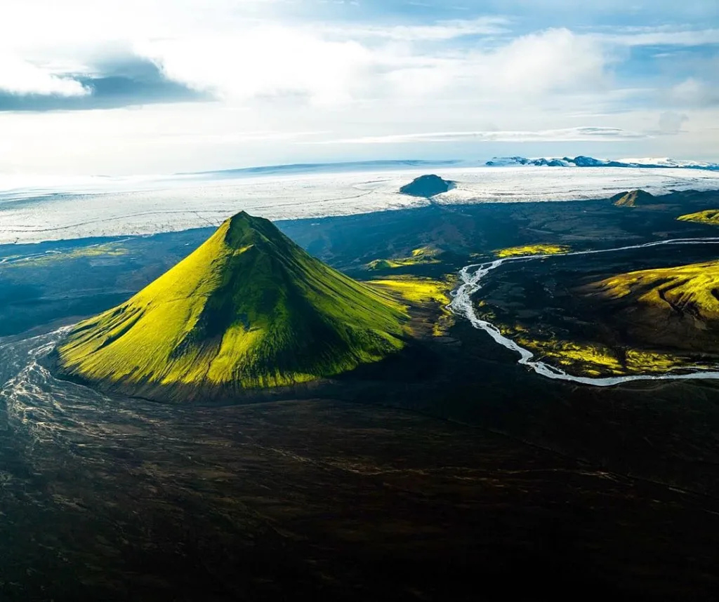
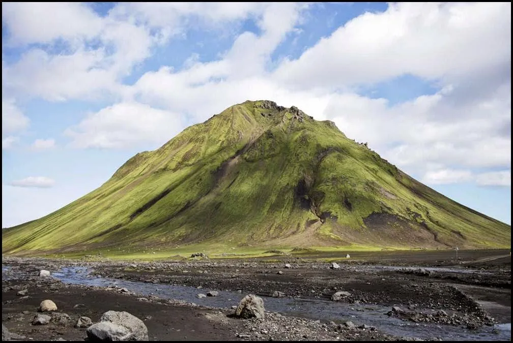
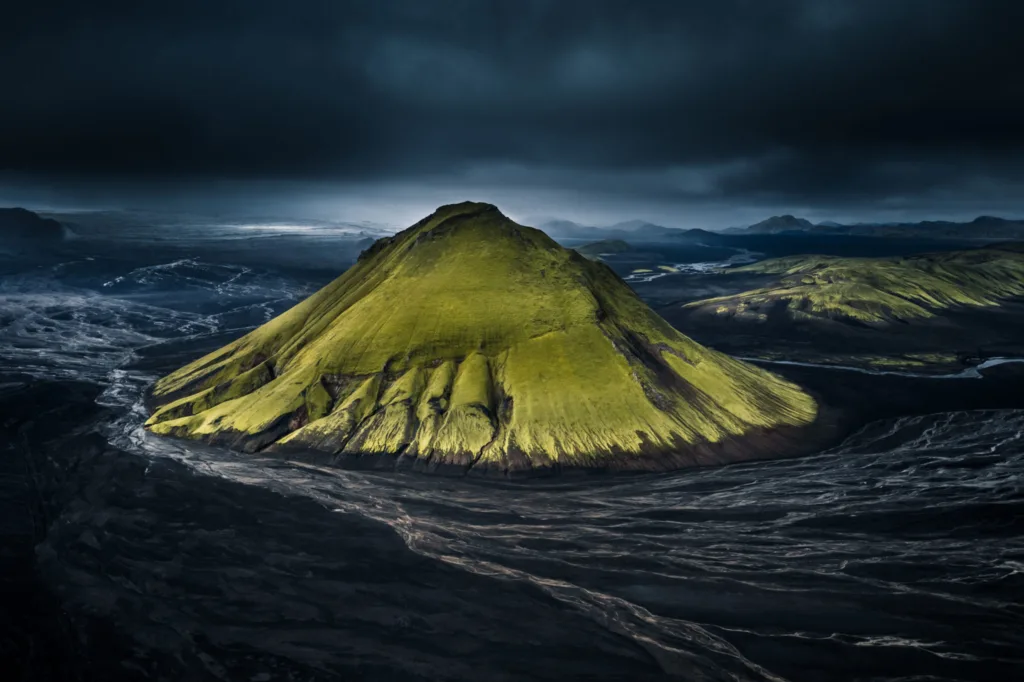
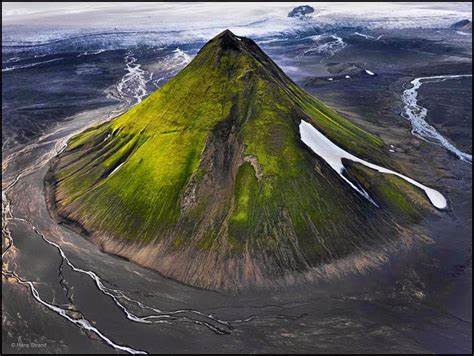
Maelifell Volcano is a prominent volcanic feature located in southern Iceland. It is situated in the Mýrdalsjökull glacier, which covers the central part of the Katla volcano caldera. Maelifell Volcano is approximately 10 kilometers east of the main caldera and rises to an elevation of 764 meters (2,507 feet) above sea level.
Geologically, Maelifell is classified as a stratovolcano, also known as a composite volcano. Stratovolcanoes are characterized by their steep-sided cones built up by layers of volcanic ash, lava flows, and other volcanic materials. These volcanoes are typically associated with explosive eruptions and can reach considerable heights.
Maelifell Volcano formed as a result of volcanic activity along the Mid-Atlantic Ridge, which runs through Iceland. The Mid-Atlantic Ridge is a divergent plate boundary where the North American and Eurasian tectonic plates are moving apart. This tectonic activity creates a zone of volcanic activity, including the formation of volcanoes like Maelifell.
The specific formation of Maelifell is linked to the Katla volcano system. Katla is one of Iceland’s most active and potentially hazardous volcanoes, with numerous eruptions throughout history. Maelifell Volcano is considered a satellite cone of Katla, meaning it formed as a secondary vent on the flanks of the main volcano. The eruption products from Katla, such as volcanic ash and lava flows, contributed to the construction of Maelifell.
Maelifell’s distinctive appearance is due to its unique geological makeup. The volcano is composed of alternating layers of volcanic ash and basaltic lava flows. The ash layers give the mountain a dark appearance, while the lava flows add rugged texture to its slopes. Additionally, the summit of Maelifell is characterized by a flat-topped cone, which is relatively rare among Icelandic volcanoes and adds to its distinctiveness.
Overall, Maelifell Volcano is an intriguing geological feature in Iceland, formed through the dynamic processes of volcanic activity along the Mid-Atlantic Ridge and the interactions with the Katla volcano system.
Physical Characteristics of Maelifell Volcano
Maelifell Volcano exhibits several distinctive physical characteristics that make it visually striking and unique. Here are some of its notable physical features:
- Cone Shape: Maelifell has a well-defined cone shape, with steep and symmetrical sides. The cone is composed of layers of volcanic ash and basaltic lava flows, giving it a textured appearance.
- Flat Summit: One of the most distinctive features of Maelifell is its flat-topped summit. Unlike many other Icelandic volcanoes, which typically have conical or cratered summits, Maelifell’s summit is relatively flat, resembling a tabletop. This feature is quite rare among Icelandic volcanoes.
- Dark Basaltic Rocks: The slopes of Maelifell are composed of dark basaltic rocks. These rocks are rich in iron and magnesium minerals, giving them a black or dark gray color. The contrast between the dark rocks and the surrounding landscape adds to Maelifell’s visual appeal.
- Vegetation: Maelifell is known for its vibrant green moss covering its slopes. The moss thrives in the moist climate of southern Iceland and adds a striking contrast to the dark volcanic rocks. This combination of black volcanic rocks and lush green moss creates a visually captivating scene.
- Location within Mýrdalsjökull Glacier: Maelifell is situated within the Mýrdalsjökull glacier, which covers the central part of the Katla volcano caldera. The glacier provides a dramatic backdrop for the volcano, with its ice cap and glacial tongues flowing down the surrounding valleys.
- Size and Elevation: Maelifell Volcano stands at an elevation of 764 meters (2,507 feet) above sea level. While it is not exceptionally tall compared to other volcanoes, its prominent cone shape and unique appearance make it visually striking and easily recognizable.
These physical characteristics contribute to the allure and beauty of Maelifell Volcano, making it a popular destination for photographers, hikers, and nature enthusiasts visiting Iceland.
Volcanic Activity
The volcanic activity of Maelifell Volcano is closely linked to the larger Katla volcano system. Katla is known for its frequent eruptions, and Maelifell is considered a satellite cone of Katla, indicating its connection to the main volcano. While Maelifell itself has not had any recent documented eruptions, it is important to note that volcanic activity can be unpredictable, and future eruptions cannot be ruled out.
Katla volcano, which Maelifell is associated with, has a history of powerful and explosive eruptions. These eruptions often involve the release of large amounts of volcanic ash, gas, and potentially dangerous pyroclastic flows. The last eruption of Katla occurred in 1918, and since then, there have been periods of increased seismic activity and volcanic unrest, indicating that the volcano remains active.
Monitoring systems are in place to detect any signs of volcanic activity in the region. This includes seismic monitoring, gas measurements, ground deformation measurements, and satellite monitoring. These tools help scientists and authorities monitor the volcano’s behavior and provide early warnings if volcanic unrest or an eruption is imminent.
It is worth noting that volcanic activity in the region can have significant impacts on the surrounding environment and communities. Eruptions can lead to the melting of glacial ice, resulting in floods known as jökulhlaups. These floods can cause damage to infrastructure and pose risks to nearby settlements.
In summary, while Maelifell Volcano has not erupted in recent history, its association with the active Katla volcano system suggests that future volcanic activity is possible. Continuous monitoring and research are essential for understanding the behavior of these volcanoes and mitigating potential risks associated with volcanic activity in the region.
Maelifell as a Tourist Destination
Maelifell Volcano is a popular tourist destination in Iceland due to its unique and captivating beauty. Here are some reasons why Maelifell attracts visitors:
- Scenic Beauty: Maelifell is renowned for its stunning natural scenery. The contrast between the dark basaltic rocks and the vibrant green moss creates a visually striking landscape. The cone-shaped volcano, with its flat-topped summit, stands out amidst the surrounding Mýrdalsjökull glacier. The picturesque setting provides ample opportunities for photography and immersing oneself in Iceland’s natural beauty.
- Hiking and Exploration: Maelifell offers hiking opportunities for outdoor enthusiasts. There are trails leading to the volcano that allow visitors to get closer to the site and experience the volcanic terrain firsthand. Exploring the slopes of Maelifell and the surrounding area offers a chance to witness the unique geological features and enjoy the tranquility of the Icelandic wilderness.
- Remote and Off-the-Beaten-Path Experience: Maelifell is located in a remote part of southern Iceland, which adds to its allure for travelers seeking an off-the-beaten-path experience. The journey to reach Maelifell involves traversing rugged landscapes and gravel roads, enhancing the sense of adventure and discovery.
- Photography Opportunities: The visually striking features of Maelifell make it a favorite spot for photographers. The contrast of colors, the play of light and shadow, and the dramatic backdrop of the glacier provide endless opportunities for capturing breathtaking shots.
- Natural Environment: Maelifell is situated within the Mýrdalsjökull glacier, which is not only visually impressive but also offers a glimpse into Iceland’s glacial environment. The surrounding area is characterized by vast ice caps, glacial tongues, and glacial rivers, creating a unique and pristine natural setting.
- Cultural and Historical Significance: Maelifell Volcano is part of Iceland’s volcanic and geological heritage. Exploring the volcano allows visitors to learn about the country’s geology, volcanic activity, and the ongoing research and monitoring efforts in the region. Additionally, the folklore and legends associated with Icelandic volcanoes add to the cultural significance of Maelifell.
It is important to note that when visiting Maelifell or any other natural attraction in Iceland, respecting the environment, following designated trails, and adhering to safety guidelines are crucial to preserving the natural beauty and ensuring a safe and enjoyable experience.
Maelifell Volcano FAQs
Can I climb to the summit of Maelifell Volcano?
Access to the summit of Maelifell is restricted to protect the fragile ecosystem and preserve the volcanic formation. Climbing to the summit is generally not permitted. However, there are hiking trails in the area that allow you to get closer to the volcano and explore its surroundings.
Is it possible to visit Maelifell all year round?
Maelifell Volcano is located in a remote and challenging environment, and accessibility can be affected by weather and road conditions. In winter, the area is often covered in snow and ice, making it more difficult to access. The summer months (June to September) generally offer the best conditions for visiting, but it’s always advisable to check local conditions and road closures before planning your trip.
How do I get to Maelifell Volcano?
To reach Maelifell, you will need to drive or join a guided tour. The volcano is located in southern Iceland, within the Mýrdalsjökull glacier. Access is via the F249 gravel road, which can be rough and challenging to drive, especially for smaller vehicles. It’s recommended to have a 4×4 vehicle with good ground clearance. Additionally, joining a guided tour can provide you with a knowledgeable guide and ensure a smoother journey.
Are there any facilities or services near Maelifell?
The area around Maelifell is remote and lacks services and facilities. There are no accommodations, restaurants, or restrooms in the immediate vicinity. It’s important to be prepared and bring necessary supplies such as food, water, and appropriate clothing for the weather conditions. It’s also advisable to have a full tank of fuel before embarking on your journey.
Is it safe to visit Maelifell considering the volcanic activity in the region?
Maelifell is associated with the active Katla volcano system, which can potentially erupt. While volcanic activity cannot be predicted with certainty, monitoring systems are in place to detect any signs of unrest. It’s important to stay informed about the current volcanic and safety conditions in the area. Follow any instructions or warnings from local authorities and respect any closures or restrictions in place.
Can I camp near Maelifell?
Camping is generally not allowed near Maelifell or within the immediate vicinity. However, there are designated campsites in the region where you can stay overnight. It’s important to follow camping regulations, practice Leave No Trace principles, and respect the natural environment.


:max_bytes(150000):strip_icc()/GettyImages-846770942-5b473114c9e77c0037e29e0e.jpg)