


")


Gravity surveys are geophysical techniques used to measure the variations in the Earth’s gravitational field at different locations. These surveys involve the measurement of the gravitational acceleration at the Earth’s surface, typically expressed in terms of milligals (mGal) or microgals (μGal). The purpose of gravity surveys is to map and understand the distribution of subsurface density variations, which can provide valuable information about the geological structure and composition of the Earth’s interior.

Gravity surveys are based on the fundamental principle that variations in subsurface density cause corresponding variations in the local gravitational field. High-density materials, such as rocks and minerals, exert a stronger gravitational pull than low-density materials like water or air. By measuring these gravitational variations, scientists can infer the distribution of different rock types and geological structures beneath the Earth’s surface.
Historical Overview: Gravity surveys have a long history in geophysics, dating back to the 17th century when Sir Isaac Newton first formulated the law of universal gravitation. However, it wasn’t until the 20th century that precise gravity measurements became practical with the development of accurate instruments.
In the early 20th century, gravity surveys started to play a crucial role in oil and mineral exploration. Gravity measurements became a standard tool for identifying subsurface structures and locating potential resources. The advent of more sophisticated instrumentation, including gravimeters and satellite-based gravity measurements, has further enhanced the precision and scope of gravity surveys in modern geophysics.
Importance in Geophysics: Gravity surveys are fundamental to the field of geophysics, providing critical information about the Earth’s subsurface. Some key aspects of their importance include:
- Resource Exploration: Gravity surveys are widely used in the exploration for natural resources such as oil, gas, and minerals. Variations in subsurface density can indicate the presence of geological structures associated with these valuable resources.
- Understanding Geological Structures: Gravity data helps geophysicists map and understand the distribution of subsurface geological structures such as faults, folds, and basins. This information is vital for geological studies and natural hazard assessments.
- Crustal Studies: Gravity surveys contribute to our understanding of the Earth’s crustal structure. They help identify variations in crustal thickness, composition, and tectonic processes, providing insights into the Earth’s dynamic evolution.
- Environmental and Engineering Applications: Gravity surveys are used in environmental studies to assess groundwater resources and monitor changes in subsurface water storage. In engineering, they aid in the evaluation of subsurface conditions for construction projects.
- Satellite-Based Gravity Measurements: Advances in satellite technology have enabled the collection of gravity data on a global scale. Satellite gravity measurements contribute to studies of Earth’s overall mass distribution, sea level changes, and large-scale geological processes.
In summary, gravity surveys are a versatile and essential tool in geophysics, providing valuable information for a wide range of applications, from resource exploration to understanding the Earth’s structure and dynamics.
Basic Principles of Gravity
Newton’s Law of Gravitation: Newton’s law of gravitation, formulated by Sir Isaac Newton in 1687, is a fundamental principle that describes the gravitational attraction between two objects with mass. The law is expressed mathematically as:
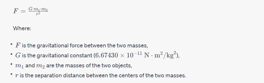
This law states that every point mass attracts every other point mass in the universe with a force that is directly proportional to the product of their masses and inversely proportional to the square of the distance between their centers.
Gravity as a Force: Gravity is considered a force of attraction between objects with mass. According to Newton’s law of gravitation, every object in the universe attracts every other object with a force. The force of gravity is responsible for phenomena such as the falling of objects, the orbits of planets around the sun, and the tides on Earth.
Gravity is a universal force, acting on all objects with mass, and it is always attractive. The strength of the gravitational force depends on the masses of the objects involved and the distance between them. Larger masses and shorter distances result in stronger gravitational forces.
Gravitational Acceleration: Gravitational acceleration, often denoted as g, is the acceleration experienced by an object due to the gravitational pull of a massive body, such as the Earth. Near the Earth’s surface, the gravitational acceleration is approximately 9.8 m/s29.8 m/s2 and is directed towards the center of the Earth.

This formula implies that all objects, regardless of their mass, experience the same gravitational acceleration near the Earth’s surface. It is important to note that gravitational acceleration decreases with altitude above the Earth’s surface and increases with depth below the surface, as it depends on the distance from the center of the Earth.
In summary, Newton’s law of gravitation describes the force of attraction between masses, gravity is considered a force, and gravitational acceleration represents the acceleration experienced by an object due to gravity. These principles form the basis for understanding and calculating gravitational interactions in various contexts.
Instrumentation

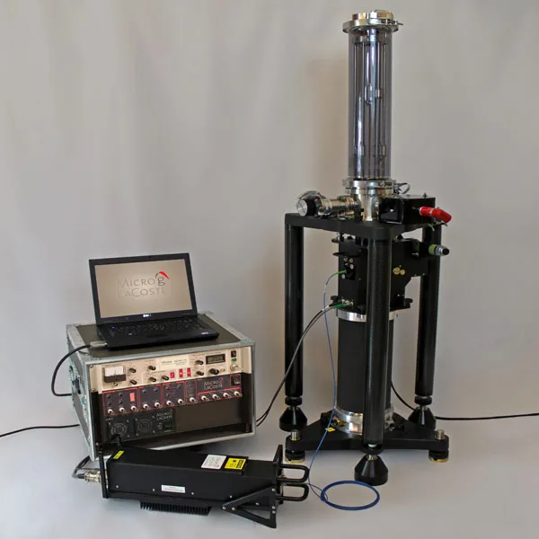
Gravimeters: Gravimeters are instruments designed to measure the local gravitational acceleration at a specific location. These instruments are crucial in gravity surveys and various geophysical applications. Gravimeters operate on the principle that the force of gravity acting on a test mass can be measured to determine the local gravitational field strength. There are several types of gravimeters, each with its own design and sensitivity.
Types of Gravimeters:
- Spring Gravimeters:
- Principle: Spring gravimeters operate based on Hooke’s law, where the displacement of a spring is proportional to the force applied to it. The test mass is attached to a spring, and the gravitational force causes the spring to stretch or compress.
- Operation: As the test mass moves, the displacement of the spring is measured and used to calculate the gravitational acceleration.
- Accuracy: Spring gravimeters are generally less accurate than more modern types but are still suitable for many gravity survey applications.
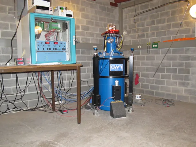
- Superconducting Gravimeters:
- Principle: Superconducting gravimeters use the principle of electromagnetic levitation. A superconducting sphere is levitated using magnetic fields, and any change in its position is a measure of the gravitational force.
- Operation: Changes in the position of the superconducting sphere are detected and converted into a measure of gravitational acceleration.
- Accuracy: Superconducting gravimeters are among the most accurate and sensitive gravimeters, making them suitable for high-precision gravity measurements.
- Atomic Gravimeters:
- Principle: Atomic gravimeters use the interference of matter waves to measure gravitational acceleration. Atoms are manipulated using lasers and other techniques to create an interferometer, and the interference pattern is used to determine gravitational acceleration.
- Operation: The interference pattern is affected by the local gravitational field, allowing for highly precise measurements.
- Accuracy: Atomic gravimeters are also capable of high precision and are used in specialized applications.
Measurement Units:
The measurement of gravity is typically expressed in units of acceleration. Commonly used units include:
- Gal (Galileo):
- Named after Galileo Galilei, this is the basic unit of acceleration due to gravity. 1 Gal is equal to 1 centimeter per second squared (cm/s²). In practice, gravity values are often expressed in milligals (mGal), where 1 mGal is equal to 0.001 Gal.
- Microgal (μGal):
- Often used for very precise measurements, especially in gravity surveys or when studying subtle gravitational variations. 1 μGal is equal to 0.000001 Gal.
These units are used to quantify the strength of the gravitational field at a particular location and are essential for interpreting gravity survey data. In gravity surveys, variations in gravitational acceleration are measured in milligals or microgals to detect subtle changes in subsurface density and geological structures.
Gravity Anomalies

Definition and Types:
Gravity anomalies refer to deviations from the expected or normal gravitational field at a particular location on the Earth’s surface. These anomalies can be caused by variations in subsurface density, topography, and geological structures. Gravity anomalies are crucial in geophysics and are often measured during gravity surveys to provide insights into the underlying geological features.
Types of Gravity Anomalies:
- Free-air Anomaly:
- Definition: The free-air anomaly represents the difference between the observed gravitational acceleration at a specific location and the theoretical gravitational acceleration at that location due to the Earth’s shape and rotation. It is the simplest form of gravity anomaly and is calculated without correcting for the influence of topography and local mass variations.
- Causes: Free-air anomalies are influenced by variations in subsurface density and topography.
- Bouguer Anomaly:
- Definition: The Bouguer anomaly is a gravity anomaly that takes into account the effects of topography on gravity. It is calculated by removing the gravitational effect of surface topography and considering only the gravitational attraction of subsurface masses. This correction helps to isolate the contribution of subsurface density variations.
- Correction: The Bouguer correction involves subtracting the gravitational attraction of the elevated terrain from the observed gravity value. This correction is typically applied using the Bouguer formula: Bouguer Anomaly=Observed Gravity−Bouguer CorrectionBouguer Anomaly=Observed Gravity−Bouguer Correction
- Applications: Bouguer anomalies are valuable for geological studies as they provide information about subsurface density variations, helping to identify features such as basins, faults, and ore bodies.
- Isostatic Anomaly:
- Definition: The isostatic anomaly accounts for variations in the Earth’s crustal thickness and isostatic equilibrium. Isostatic equilibrium refers to the balance between the uplift and subsidence of the Earth’s crust to achieve gravitational and buoyant equilibrium. Isostatic anomalies help in understanding the compensation mechanisms of the Earth’s lithosphere.
- Causes: Isostatic anomalies arise due to variations in crustal thickness and density. For example, regions with thicker crust may exhibit positive isostatic anomalies, while regions with thinner crust may show negative isostatic anomalies.
- Applications: Isostatic anomalies are essential in tectonic studies and understanding the geological history of a region. They provide insights into crustal processes and the effects of past tectonic events.
In summary, gravity anomalies are variations in the Earth’s gravitational field, and three common types include free-air anomalies, Bouguer anomalies, and isostatic anomalies. Each type provides distinct information about subsurface density, topography, and lithospheric processes, making them valuable tools in geological and geophysical investigations.
Gravity Data Acquisition
Acquiring gravity data involves conducting gravity surveys in the field. The accuracy and reliability of the acquired data depend on careful planning, proper instrumentation, and adherence to established survey design principles. Here are the key aspects of gravity data acquisition:
Field Procedures:
- Instrument Calibration:
- Before starting the survey, gravimeters must be calibrated to ensure accurate measurements. Calibration involves checking and adjusting the instrument’s response to gravity.
- Benchmark Establishment:
- Establishing benchmarks at known elevations is crucial for accurate gravity measurements. These benchmarks serve as reference points for both gravity and elevation data.
- Station Setup:
- Gravity measurements are typically taken at designated survey stations. Careful attention must be paid to the station setup to ensure stability and minimize external disturbances. Stations should be chosen to cover the survey area adequately.
- Data Collection:
- Gravimeters are positioned at each survey station, and measurements are taken. Readings are recorded at each station, and the process is repeated across the survey area.
- Elevation Data:
- Along with gravity data, elevation data is often collected at each station. This elevation information is essential for correcting gravity anomalies, especially when calculating Bouguer anomalies.
- Navigation and GPS:
- Accurate navigation and GPS systems are used to precisely locate each survey station. This information is crucial for georeferencing the acquired gravity data.
- Quality Control:
- Regular quality control checks are conducted during the survey to identify and correct any issues promptly. This includes checking instrument drift, ensuring proper leveling, and validating GPS positions.
Data Collection Techniques:
- Point Gravity Surveys:
- In point gravity surveys, measurements are taken at individual stations spaced across the survey area. This method is suitable for smaller, more detailed surveys.
- Profile Gravity Surveys:
- Profile gravity surveys involve taking measurements along predetermined lines or profiles. This method provides a cross-sectional view of gravity variations and is suitable for linear features or geological transects.
- Grid Gravity Surveys:
- In grid gravity surveys, measurements are taken at regularly spaced intervals to cover the entire survey area systematically. This method is suitable for regional mapping and identifying large-scale geological features.
- Airborne Gravity Surveys:
- Airborne gravity surveys involve mounting gravimeters on aircraft. This technique allows for rapid data acquisition over large and inaccessible areas. It is often used in mineral exploration and regional mapping.
Survey Design:
- Density Contrasts:
- Survey design should consider the expected density variations in the subsurface. Areas with significant density contrasts are of particular interest.
- Spacing of Stations:
- The spacing between survey stations depends on the objectives of the survey. Closer spacing is needed for detailed investigations, while larger spacing may be sufficient for regional mapping.
- Topography:
- Survey design should account for the influence of topography on gravity measurements. Bouguer corrections are applied to account for the gravitational effects of surface topography.
- Survey Area Extent:
- The extent of the survey area should be carefully determined based on the geological and geophysical objectives. It may involve considering regional geological structures, potential resource locations, or specific research questions.
- Flight Paths (for airborne surveys):
- In airborne gravity surveys, the design includes planning optimal flight paths to cover the entire survey area efficiently. Flight altitude and speed are critical parameters.
Careful consideration of these factors during survey design and execution is essential for obtaining reliable gravity data that can provide meaningful insights into subsurface geological structures and density variations.
Data Processing and Corrections in Gravity Surveys

After collecting raw gravity data in the field, several corrections are applied to account for various factors that can influence the measurements. The goal is to obtain gravity anomalies that reflect subsurface variations rather than external influences. Here are some common corrections:
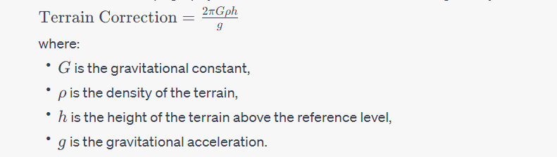
- Terrain Corrections:
- Purpose: Corrects for the gravitational effect of topography, as the elevation of the measurement point influences the observed gravity.
- Method: Calculated using digital terrain models (DTMs) to estimate the gravitational attraction of the topography. The formula for terrain correction is given by:
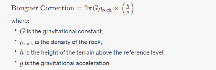
- Bouguer Corrections:
- Purpose: Corrects for the gravitational effects of masses between the measurement point and infinity, primarily the mass of the Earth’s crust.
- Method: The Bouguer correction is applied to the observed gravity to remove the effect of surface topography and calculate the Bouguer anomaly. The formula is given by:
- Latitude Corrections:
- Purpose: Corrects for the centrifugal force caused by the Earth’s rotation, which varies with latitude.
- Method: The correction is based on the formula:

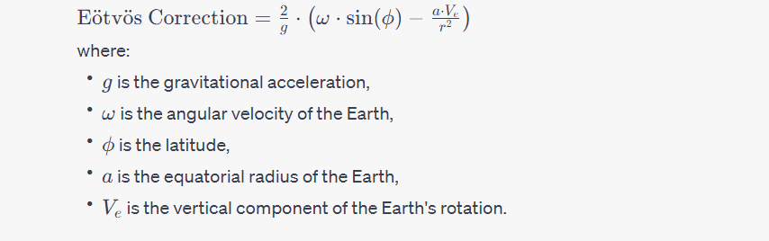
- Eötvös Corrections:
- Purpose: Corrects for the gravitational effect due to the Earth’s rotation and the non-spherical shape of the Earth.
- Method: The Eötvös correction is given by:
These corrections are essential to isolate the subsurface density variations and obtain accurate gravity anomalies, which are then used for geological and geophysical interpretations. The choice of corrections depends on the specific characteristics of the survey area and the objectives of the study.
Interpretation of Gravity Data
Interpretation of gravity data involves analyzing gravity anomalies to extract information about the subsurface geological features and density variations. This process is crucial for understanding the Earth’s structure, identifying potential mineral or hydrocarbon resources, and mapping tectonic and structural elements. Here’s a general guide on interpreting gravity data:
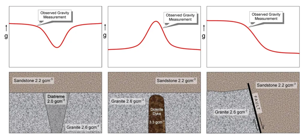
- Identifying Anomalies:
- Gravity anomalies are deviations from the expected gravitational field at a specific location. Positive anomalies often indicate higher than average subsurface density, while negative anomalies suggest lower density.
- Correlation with Geological Features:
- Correlate gravity anomalies with known geological features in the region. Certain geological structures, such as faults, basins, and mountain ranges, can be associated with distinct gravity anomalies.
- Regional vs. Local Anomalies:
- Distinguish between regional and local anomalies. Regional anomalies cover large areas and may be associated with deep-seated geological structures, while local anomalies are often linked to shallower features.
- Bouguer Anomalies:
- Analyze Bouguer anomalies, which have been corrected for the effects of topography. Bouguer anomalies provide a clearer picture of subsurface density variations by removing the gravitational effects of surface features.
- Isostatic Anomalies:
- Consider isostatic anomalies, especially in areas with significant variations in crustal thickness. Positive isostatic anomalies may indicate regions of uplift or thickened crust, while negative anomalies can suggest subsidence or thinner crust.
- Gradient Analysis:
- Examine gradients in gravity data to identify boundaries between geological units. Steep gradients may indicate fault zones or other abrupt changes in subsurface composition.
- Integration with Other Data:
- Integrate gravity data with other geophysical data, such as seismic surveys or magnetic data, for a more comprehensive understanding of subsurface structures.
- Depth Estimation:
- Attempt to estimate the depth to the source of gravity anomalies. Different mathematical and modeling techniques can be applied to infer the depth of density contrasts contributing to the anomalies.
- Hydrocarbon Exploration:
- In the context of hydrocarbon exploration, gravity data can be used to identify potential sedimentary basins, salt domes, or other structural traps that may contain oil and gas deposits.
- Mineral Exploration:
- Gravity surveys are valuable in mineral exploration. Certain minerals, like dense metallic ores, can create distinctive gravity anomalies. Anomalies may indicate the presence of mineral deposits.
- Modeling and Inversion:
- Advanced interpretation may involve numerical modeling and inversion techniques to create subsurface models that best fit the observed gravity data. These methods help refine the understanding of geological structures.
- Scientific Research:
- Gravity data interpretation is also essential for scientific research, contributing to our understanding of Earth’s dynamics, tectonic processes, and the composition of the crust and mantle.
Interpreting gravity data requires a combination of geological knowledge, expertise in geophysics, and an understanding of the regional tectonic and geological context. Collaborative efforts between geophysicists, geologists, and other experts enhance the accuracy and reliability of the interpretations.
Applications of Gravity Surveys

Gravity surveys have a wide range of applications across various scientific, industrial, and environmental fields. Here are some key applications:
- Mineral Exploration:
- Gravity surveys are crucial in mineral exploration for identifying subsurface structures associated with mineral deposits. Density variations related to ore bodies, faults, and geological structures can be detected through gravity anomalies.
- Oil and Gas Exploration:
- In the exploration for oil and gas, gravity surveys help identify sedimentary basins, salt domes, and other geological structures that may contain hydrocarbon reservoirs. Gravity data, when integrated with other geophysical methods, assists in mapping potential exploration targets.
- Groundwater Exploration:
- Gravity surveys can be used to locate and assess groundwater resources. Variations in subsurface density related to aquifers and groundwater distribution can be detected, aiding in groundwater resource management.
- Geological Mapping:
- Gravity surveys contribute to geological mapping by revealing subsurface structures, fault lines, and variations in crustal thickness. This information is valuable for understanding the geological history and evolution of a region.
- Environmental Studies:
- Gravity surveys are used in environmental studies to investigate subsurface structures related to natural hazards such as landslides, earthquakes, and volcanic activity. Understanding subsurface geology is essential for assessing potential risks.
- Civil Engineering:
- In civil engineering projects, gravity surveys help assess the stability of the ground and identify potential challenges related to subsurface conditions. This information is critical for infrastructure projects such as dams, bridges, and tunnels.
- Archaeological Investigations:
- Gravity surveys can be applied in archaeological studies to detect buried structures or anomalies indicative of archaeological features. This non-invasive method aids in site assessments and cultural heritage preservation.
- Tectonic Studies:
- Gravity surveys contribute to tectonic studies by providing information about the Earth’s crustal structure, subsurface composition, and tectonic processes. They help researchers understand the dynamics of tectonic plates and the forces shaping the Earth’s crust.
- Isostatic Studies:
- Gravity surveys are employed in isostatic studies to analyze variations in crustal thickness and isostatic equilibrium. This information contributes to understanding the compensating adjustments in the Earth’s lithosphere.
- Space Exploration:
- Gravity data is crucial for space missions and planetary exploration. Understanding gravitational anomalies on other celestial bodies provides insights into their internal structure and geological features.
- Climate and Environmental Change:
- Gravity data can be used to monitor changes in water storage, such as variations in ice mass or groundwater levels. This information contributes to studies on climate change and its impacts on Earth’s systems.
- Global Geoid Modeling:
- Gravity data is used to model the geoid, which represents the Earth’s equipotential surface of gravitational potential energy. Accurate geoid models are essential for precise measurements and mapping on the Earth’s surface.
In summary, gravity surveys play a versatile and essential role in various scientific and applied fields, contributing to our understanding of the Earth’s structure, resources, and environmental conditions. The information obtained from gravity surveys is valuable for making informed decisions in resource exploration, environmental management, and scientific research.
Case Studies
While I can’t provide real-time or the latest case studies, I can offer examples of historical or generic case studies to illustrate how gravity surveys have been applied in different scenarios.
- Mineral Exploration in Canada:
- Objective: Identify potential mineral deposits in a remote region of Canada.
- Method: Airborne gravity surveys were conducted over the target area. Gravity anomalies were analyzed to identify subsurface structures associated with mineralization.
- Results: The survey successfully located anomalies indicative of dense rock formations. Follow-up ground-based exploration confirmed the presence of valuable mineral deposits, leading to a significant mining operation.
- Oil and Gas Exploration in the Gulf of Mexico:
- Objective: Locate potential hydrocarbon reservoirs beneath the seafloor in the Gulf of Mexico.
- Method: Marine gravity surveys were conducted using ships equipped with gravimeters. Gravity data, along with seismic data, helped map subsurface structures related to potential oil and gas reserves.
- Results: The surveys identified promising areas with significant gravity anomalies, leading to successful drilling operations and the discovery of new oil and gas fields.
- Geothermal Resource Assessment in Iceland:
- Objective: Assess the geothermal potential in a volcanic region in Iceland for sustainable energy development.
- Method: Gravity surveys were combined with other geophysical methods to map subsurface structures, including magma chambers and heat reservoirs. The aim was to identify areas with high geothermal potential.
- Results: The gravity surveys played a crucial role in identifying subsurface features associated with geothermal activity. This information guided the development of geothermal power plants, contributing to Iceland’s use of renewable energy.
- Environmental Hazard Assessment in California:
- Objective: Assess the risk of landslides in a hilly region prone to geological hazards in California.
- Method: Gravity surveys were conducted to map subsurface structures and identify potential landslide-prone areas. The goal was to provide early warning and inform land-use planning.
- Results: The gravity surveys revealed areas with anomalous subsurface density, indicating potential instability. This information was used for risk assessment and implementing preventive measures, reducing the risk of landslides.
- Archaeological Site Investigation in Egypt:
- Objective: Explore the subsurface near an archaeological site in Egypt for buried structures.
- Method: Ground-based gravity surveys were conducted to detect density anomalies associated with potential archaeological features.
- Results: The gravity surveys identified anomalies indicative of buried structures, leading to targeted excavations. Archaeological discoveries were made, shedding light on the historical significance of the site.
These case studies demonstrate the versatility of gravity surveys in diverse applications, from resource exploration and environmental assessment to archaeological investigations. The integration of gravity data with other geophysical methods enhances the understanding of subsurface structures and contributes to informed decision-making in various fields.
Advancements in Gravity Survey Technology
Advancements in gravity survey technology have occurred over the years, leading to improvements in data accuracy, acquisition efficiency, and the ability to conduct surveys in challenging environments. Here are some key advancements:
- Improved Gravimeter Technology:
- Superconducting Gravimeters: These gravimeters use superconducting materials to achieve extremely high sensitivity, allowing for the detection of even subtle changes in gravity. Superconducting gravimeters are highly accurate and are used in applications requiring precision, such as crustal deformation studies.
- Quantum Gravimeters: Emerging quantum technologies, including atom interferometry and atom cloud expansion, are being applied to gravimetry. Quantum gravimeters have the potential to provide unprecedented sensitivity and precision, surpassing traditional instruments.
- Airborne Gravity Gradiometry:
- Airborne Gravity Gradiometers (AGG): Gravity gradiometry involves measuring the spatial gradient of gravity. AGGs, mounted on aircraft, can collect data over large areas rapidly. This technology is especially valuable in regional surveys and mineral exploration, where quick and high-density data acquisition is essential.
- Satellite-Based Gravity Measurements:
- Gravity Recovery and Climate Experiment (GRACE): GRACE was a satellite mission designed to measure variations in Earth’s gravity field over time. It provided valuable insights into mass redistribution, including changes in ice mass, water storage, and tectonic processes.
- GRACE Follow-On (GRACE-FO): A successor to the GRACE mission, GRACE-FO continues the monitoring of Earth’s gravity field using twin satellites. It contributes to climate studies, hydrology, and understanding large-scale mass movements.
- Innovations in Data Processing and Inversion:
- Advanced Inversion Techniques: Improved inversion algorithms and computational methods allow for more accurate interpretation of gravity data. Inversion techniques help create detailed subsurface models by considering multiple geophysical datasets simultaneously.
- Machine Learning and Artificial Intelligence: These technologies are increasingly being applied to process and interpret gravity data. Machine learning algorithms can assist in pattern recognition, noise reduction, and the identification of geological features.
- Integrated Geophysical Surveys:
- Multisensor Integration: Combining gravity surveys with other geophysical methods, such as magnetic surveys, seismic studies, and electromagnetic surveys, provides a more comprehensive understanding of subsurface structures. Integrated surveys enhance the accuracy of geological interpretations.
- Miniaturization and Portability:
- Miniaturized Gravimeters: Advances in sensor technology have led to the development of smaller and more portable gravimeters. These instruments are suitable for a wide range of applications, including field surveys in challenging terrains.
- Real-Time Data Transmission:
- Wireless and Satellite Communication: Gravimeters equipped with real-time data transmission capabilities allow for immediate data access and analysis. This is particularly useful for survey planning, quality control, and decision-making in the field.
- High-Resolution Global Gravity Models:
- GOCE (Gravity field and steady-state Ocean Circulation Explorer): GOCE was a European Space Agency (ESA) satellite mission dedicated to measuring Earth’s gravity field with unprecedented accuracy. It contributed to the creation of high-resolution global gravity models.
These advancements collectively contribute to more efficient, accurate, and versatile gravity surveys, expanding their applications in scientific research, resource exploration, environmental studies, and various other fields. Ongoing research and technological developments continue to push the boundaries of gravity survey capabilities.
Conclusion: Summary of Key Points
Summary of Key Points:
- Gravity Surveys Definition:
- Gravity surveys involve measuring variations in the Earth’s gravitational field to understand subsurface density variations and geological structures.
- Basic Principles:
- Newton’s Law of Gravitation governs the gravitational force between masses, with gravity expressed as a force and gravitational acceleration representing the acceleration due to gravity.
- Instrumentation:
- Gravimeters, such as spring gravimeters, superconducting gravimeters, and atomic gravimeters, are used to measure gravity. Measurement units include the Gal, milligal, and microgal.
- Gravity Anomalies:
- Anomalies result from deviations in the expected gravitational field. Types include free-air, Bouguer, and isostatic anomalies.
- Data Acquisition:
- Field procedures involve calibration, benchmark establishment, station setup, data collection, elevation data, navigation, and quality control. Data collection techniques include point, profile, and grid surveys, as well as airborne surveys.
- Corrections:
- Terrain, Bouguer, latitude, and Eötvös corrections are applied to account for topography, subsurface density, latitude, and the Earth’s rotation.
- Interpretation:
- Gravity data interpretation involves identifying anomalies, correlating with geological features, distinguishing regional and local anomalies, and integrating with other geophysical data. It aids in depth estimation, mineral and oil exploration, environmental studies, and archaeological investigations.
- Applications:
- Gravity surveys find applications in mineral and oil exploration, groundwater assessment, geological mapping, environmental studies, civil engineering, archaeology, tectonic studies, and space exploration.
- Advancements in Technology:
- Advancements include improved gravimeter technology, airborne gravity gradiometry, satellite-based gravity measurements, innovations in data processing, machine learning, and miniaturization. These enhance data accuracy, acquisition efficiency, and survey capabilities.
Importance of Gravity Surveys in Geophysics:
Gravity surveys are crucial in geophysics for several reasons:
- Mapping Subsurface Structures:
- Gravity surveys help map subsurface structures, providing insights into geological features, fault lines, and variations in crustal thickness.
- Resource Exploration:
- In mineral, oil, and gas exploration, gravity surveys identify anomalies indicative of potential resource deposits, aiding in efficient exploration.
- Environmental Studies:
- Gravity data contribute to environmental studies by assessing subsurface conditions related to landslides, earthquakes, and groundwater resources.
- Geological Understanding:
- Gravity surveys enhance our understanding of the Earth’s geological history, tectonic processes, and crustal composition.
- Engineering Applications:
- In civil engineering, gravity surveys assist in assessing ground stability, influencing infrastructure projects such as dams, bridges, and tunnels.
- Scientific Research:
- Gravity data contribute to scientific research, climate studies, and space exploration, providing valuable information about Earth’s dynamics and gravitational field.
In conclusion, gravity surveys are versatile and essential tools in geophysics, playing a critical role in diverse applications that contribute to our understanding of the Earth and its resources. Ongoing technological advancements continue to expand the capabilities and impact of gravity surveys in various scientific and applied fields.
 Methods")
")


