Home Blog Page 42

Migmatite

Migmatite is a type of rock that exhibits both solid-state and partial melting characteristics. It is commonly found in high-temperature metamorphic environments and is often associated with regions that have experienced intense geological processes such as mountain building or tectonic activity. The name “migmatite” is derived from the Greek words “migma,” meaning mixture, and “tecton,” meaning to melt.

Migmatite

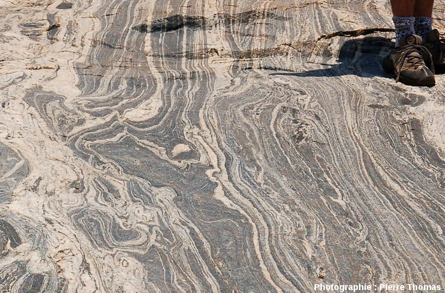
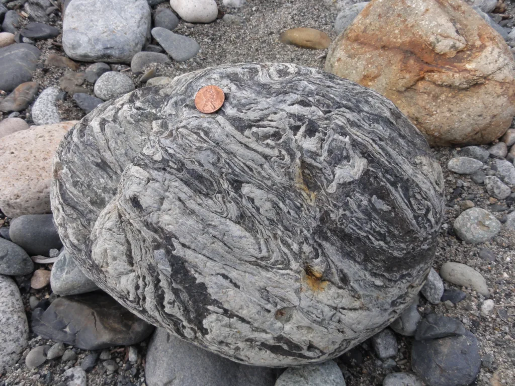
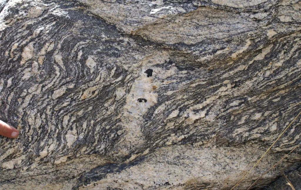
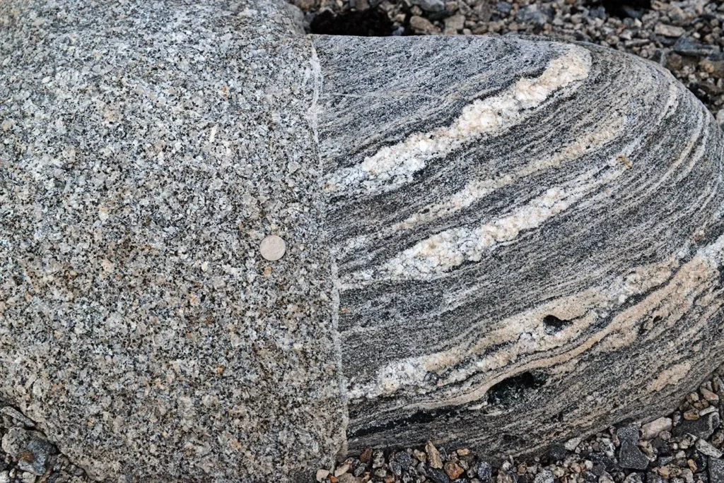
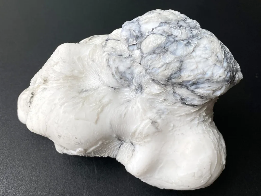
Definition of Migmatite: Migmatite is essentially a composite rock composed of two distinct components: a light-colored, granitic or felsic part known as the “leucosome” and a darker, more mafic or schistose part known as the “melanosome.” The leucosome is formed through partial melting of the original rock, often reaching temperatures close to those required for the generation of granite. The melanosome, on the other hand, remains largely unmodified and represents the solid-state, non-melted portion of the rock.

Significance in Geology:

  1. Metamorphic History Indicator: Migmatites are valuable indicators of the metamorphic history of a region. The presence of partial melting suggests that the rocks have undergone high-grade metamorphism with elevated temperatures. Studying migmatites can help geologists understand the conditions and processes that shaped the Earth’s crust over geological time.
  2. Crustal Differentiation: Migmatites provide insights into the differentiation processes occurring within the Earth’s crust. The separation of the leucosome and melanosome components reflects the separation of melt from solid residue, contributing to the formation of different rock types.
  3. Tectonic Processes: Migmatites are often associated with tectonic activity, such as convergent plate boundaries and mountain-building events. The intense pressure and heat generated during these processes can lead to partial melting and the formation of migmatites. The study of migmatites helps geologists reconstruct the tectonic history of a region.
  4. Mineral Resource Potential: Migmatites, especially those with significant granitic components, may have economic importance due to the potential presence of valuable minerals. The leucosome, being granitic, may contain economically significant elements such as quartz, feldspar, and sometimes minerals like mica.

In summary, migmatites are geologically significant rocks that provide a window into the complex processes that have shaped the Earth’s crust. Their study contributes to our understanding of metamorphism, tectonics, and the geological history of a particular region.

Formation of Migmatite

Migmatite

The formation of migmatite involves a complex interplay of high temperatures, pressure, and geological processes. The following steps outline the general process of migmatite formation:

  1. Metamorphism: Migmatites typically form in regions undergoing high-grade metamorphism. This can occur in the Earth’s crust during events such as continental collision or mountain-building processes. The intense pressure and temperature associated with these events cause the original rocks to undergo metamorphism.
  2. Increased Temperature: As rocks experience increasing temperature during metamorphism, some minerals within them begin to reach their melting points. However, not all minerals melt simultaneously due to variations in their melting temperatures.
  3. Partial Melting: The rocks undergo partial melting, resulting in the formation of a melt or magma. The minerals with lower melting points, such as quartz and feldspar, are more likely to melt, while others with higher melting points may remain in a solid state.
  4. Separation of Leucosome and Melanosome: The partial melt generated during metamorphism starts to migrate through the rock. This mobilized melt collects in certain regions, forming the light-colored, granitic leucosome. Meanwhile, the rest of the rock, which has not undergone significant melting, forms the darker, more mafic melanosome.
  5. Vein Formation: The partially molten material may migrate through fractures or veins within the rock, creating networks of leucosomes. These veins are often cross-cutting and can be observed as lighter-colored bands within the overall rock matrix.
  6. Solidification: The leucosome, having a granitic composition, may eventually solidify as the temperature decreases. This process can involve the crystallization of minerals such as quartz, feldspar, and mica within the melt.
  7. Formation of Migmatite: The end result is the formation of migmatite, a composite rock consisting of the partially melted leucosome and the solid-state melanosome. The distinctive banding or veining seen in migmatites is a result of this dual nature, with the lighter-colored leucosome contrasting against the darker melanosome.

The formation of migmatite is closely linked to the geological history and tectonic processes of a region. The study of migmatites provides important insights into the conditions and events that have shaped the Earth’s crust over time.

Characteristics of Migmatite

Migmatite

Migmatites exhibit several distinctive characteristics that set them apart from other types of rocks. These characteristics are a result of the partial melting and subsequent solidification processes that occur during high-grade metamorphism. Here are some key characteristics of migmatites:

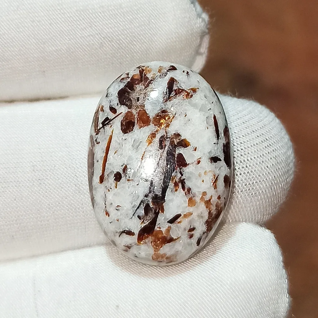
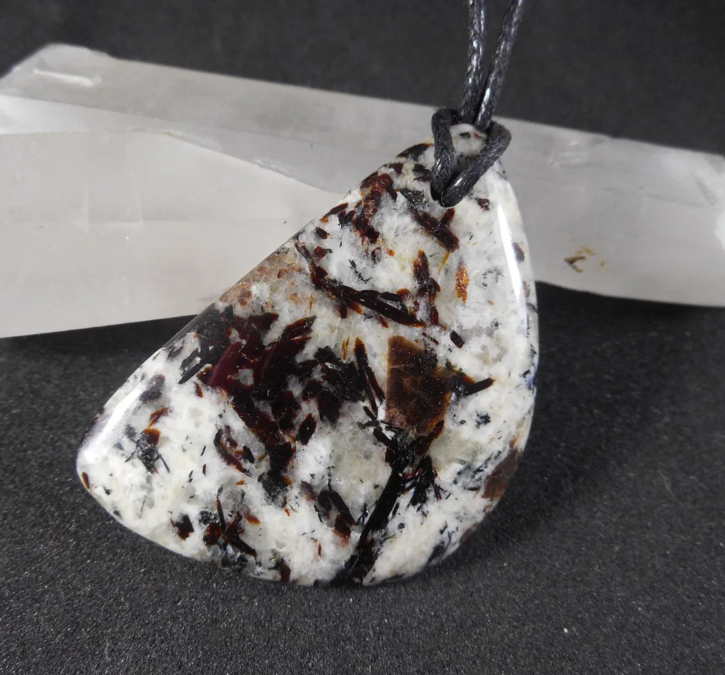
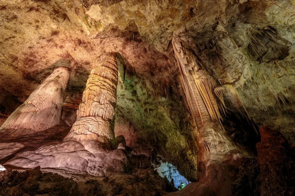
  1. Banding or Veining: Migmatites typically display a banded or veined appearance due to the segregation of the rock into two distinct components: the leucosome and melanosome. The leucosome, composed of light-colored minerals, forms veins or bands within the darker melanosome.
  2. Dual Composition: Migmatites have a dual composition, consisting of a partially melted, granitic leucosome and a solid-state, more mafic or schistose melanosome. The leucosome is enriched in felsic minerals like quartz, feldspar, and mica, while the melanosome retains a more mafic mineralogy.
  3. Leucosome Composition: The leucosome in migmatites often has a granitic or granodioritic composition. It may contain minerals such as quartz, feldspar (orthoclase and plagioclase), and mica. The specific mineral assemblage can vary depending on the original composition of the rocks undergoing metamorphism.
  4. Mafic Minerals in Melanosome: The melanosome, which represents the solid-state, non-melted portion of the rock, may contain mafic minerals such as biotite, amphibole, and sometimes garnet. The mineralogy of the melanosome reflects the composition of the original rocks prior to partial melting.
  5. High-Temperature Metamorphism: Migmatites are associated with high-temperature metamorphic environments. The partial melting that occurs during metamorphism indicates that the rocks experienced elevated temperatures, often approaching those required for the generation of granite.
  6. Formation of Veins and Network Patterns: The leucosome, formed through partial melting, may migrate through fractures or veins within the rock, creating a network of interconnected veins. This vein formation contributes to the distinctive appearance of migmatites.
  7. Pegmatitic Texture: In some migmatites, especially those with a significant leucosome component, a pegmatitic texture may be observed. This texture is characterized by the presence of large crystals in a finer-grained matrix and is a result of the slow cooling of the partially melted material.
  8. Tectonic Association: Migmatites are often associated with tectonic processes such as continental collision, subduction, orogenic events, and mountain-building. Their occurrence is closely linked to the geological history of a region.
  9. Economic Significance: Migmatites, especially those with granitic leucosomes, may have economic importance due to the potential presence of valuable minerals. The leucosome may contain economically significant elements such as quartz, feldspar, and mica.

Understanding these characteristics is crucial for geologists studying migmatites as they provide valuable insights into the geological processes and conditions that shaped the Earth’s crust over time.

Types of Migmatite

Migmatite and granite
Granite and migmatic

Migmatites can be classified into different types based on their mineralogical composition, the extent of partial melting, and other specific characteristics. Here are some common types of migmatite:

  1. Granite Migmatite: This type of migmatite has a significant leucosome composed of granitic minerals such as quartz, feldspar (orthoclase and/or plagioclase), and mica. The granitic leucosome forms distinctive veins or layers within the darker melanosome, which may contain mafic minerals.
  2. Migmatitic Gneiss: Migmatitic gneiss is characterized by the presence of both metamorphic gneiss and migmatite components. The gneissic part retains a well-developed foliation, while the migmatite component includes bands or veins of leucosome within the gneissic matrix.
  3. Migmatitic Schist: Similar to migmatitic gneiss, migmatitic schist comprises both metamorphic schist and migmatite portions. The schistose part exhibits a foliated texture, while the leucosome forms veins or layers within the schist.
  4. Mafic Migmatite: In some migmatites, the melanosome may be dominated by mafic minerals, such as biotite and amphibole. These migmatites have a darker overall appearance, with the leucosome consisting of a partial melt enriched in felsic minerals.
  5. Pegmatitic Migmatite: Pegmatitic migmatites exhibit a pegmatitic texture in the leucosome, characterized by the presence of large crystals in a finer-grained matrix. This texture is a result of slow cooling of the partially melted material.
  6. Amphibolite Migmatite: Amphibolite migmatites are characterized by the presence of amphibole in the melanosome. The leucosome, enriched in felsic minerals, forms veins or layers within the amphibolite matrix.
  7. Garnet-bearing Migmatite: Some migmatites contain garnet in either the melanosome or leucosome. The presence of garnet can provide additional information about the metamorphic conditions and the composition of the original rocks.
  8. Mixed Mineral Migmatite: Migmatites can vary widely in mineral composition depending on the original rock and the extent of partial melting. Some migmatites may exhibit a mix of both felsic and mafic minerals in both the leucosome and melanosome.
  9. Calc-silicate Migmatite: In certain geological settings, migmatites may contain calc-silicate minerals, such as wollastonite and diopside, in addition to felsic and mafic components. These migmatites often form in carbonate-rich rocks undergoing metamorphism.

The classification of migmatites is complex and may vary based on regional geological characteristics. Additionally, migmatites can show transitional features between different types, making their classification challenging in some cases. Understanding the specific type of migmatite is crucial for interpreting the geological history and conditions of the area where they are found.

Chemical Composition

Migmatite

The chemical composition of migmatites varies depending on the original composition of the protolith (the pre-existing rock) and the extent of partial melting that occurred during metamorphism. Generally, migmatites exhibit a dual composition due to the presence of both a leucosome and a melanosome. Here’s a broad overview of the chemical composition of migmatites:

  1. Leucosome (Partial Melt):
    • Quartz (SiO2): Commonly present in the leucosome, especially in granitic migmatites.
    • Feldspar (Orthoclase, Plagioclase): Both types of feldspar may be present, contributing to the felsic nature of the leucosome.
    • Mica (Muscovite, Biotite): Micas are common in the leucosome, adding to its foliated or schistose texture.
    • Aluminum Silicates: Minerals such as sillimanite or andalusite may be present, depending on the metamorphic conditions.
    • Accessories: Other minerals like garnet, staurolite, or other high-temperature metamorphic minerals may occur.
  2. Melanosome (Solid Residue):
    • Mafic Minerals: Biotite, amphibole (hornblende), and pyroxene are common in the melanosome, contributing to its darker color.
    • Feldspar: Plagioclase feldspar may be present in the melanosome, but its abundance is typically lower than in the leucosome.
    • Quartz: The melanosome may contain some quartz, but in lesser amounts compared to the leucosome.
    • Accessories: Depending on the original rock composition, minerals such as garnet or other metamorphic minerals may be present.
  3. Overall Composition:
    • Migmatites can have a range of overall compositions, from granitic (enriched in silica and aluminum) to more mafic or intermediate compositions.
    • The ratio of felsic to mafic minerals can vary, and migmatites may show transitional features between different rock types.
  4. Pegmatitic Textures:
    • In some migmatites, especially those with granitic leucosomes, pegmatitic textures may be observed. This results from the slow cooling of the partially melted material, leading to the development of large crystals.
  5. Mineral Zoning:
    • Migmatites may exhibit mineral zoning, with variations in mineral composition within both the leucosome and melanosome. This zoning can provide clues about the conditions of partial melting and solidification.

It’s important to note that the chemical composition of migmatites is highly variable, and specific details depend on the geological context, the protolith, and the metamorphic conditions. Migmatites are fascinating rocks to study because they capture a snapshot of the dynamic processes that occur during high-grade metamorphism and partial melting in the Earth’s crust.

Applications and Economic Significance

Migmatite

Migmatites, with their unique composition and geological history, have several applications and economic significance:

  1. Mineral Resources:
    • Quarrying and Mining: Migmatites, especially those with significant leucosome portions, may contain valuable minerals like quartz, feldspar, and mica. These minerals have various industrial applications, including construction materials, ceramics, and electronics. Mining operations may target migmatite deposits for these resources.
  2. Geothermal Resources:
    • Geothermal Energy Exploration: Regions with migmatites can be associated with high-temperature conditions. Studying migmatites may provide insights into geothermal energy potential, as the elevated temperatures associated with their formation could indicate areas with enhanced heat flow.
  3. Building Materials:
    • Dimension Stone: Migmatites with attractive textures and patterns, especially those with pegmatitic or foliated structures, can be quarried for dimension stone. These stones are used in architecture, countertops, and other decorative applications.
  4. Understanding Tectonic Processes:
    • Geological Research: Migmatites are often associated with tectonic processes such as continental collision or orogenesis. Studying migmatites helps geologists understand the complex interactions between tectonics, metamorphism, and partial melting, contributing to broader geological research.
  5. Oil and Gas Exploration:
    • Indicator of High-Temperature Conditions: Migmatites can serve as indicators of high-temperature metamorphism. Understanding the geological history of an area, including migmatite formation, aids in assessing the thermal history of the crust, which can have implications for oil and gas exploration.
  6. Water Resources:
    • Groundwater Studies: The presence of certain minerals in migmatites may influence groundwater quality. Studying migmatites can contribute to understanding the hydrogeology of an area, potentially impacting water resource management.
  7. Environmental Studies:
    • Site Characterization: Migmatites may be studied in environmental geology for site characterization, especially in areas prone to geological hazards. Understanding the geological characteristics of migmatite-rich regions can aid in assessing potential risks.
  8. Archaeological Studies:
    • Stone Tools: In regions where migmatites are prevalent, these rocks may have been historically used for making stone tools by ancient civilizations. Archaeological studies may involve the identification and sourcing of migmatitic rocks for understanding human activities.
  9. Education and Research:
    • Geoscience Education: Migmatites serve as excellent examples for teaching geology and petrology. They provide students with insights into complex geological processes, metamorphism, and the formation of different rock types.

While migmatites may not be directly exploited for economic gain in all cases, their study contributes significantly to scientific research, resource exploration, and the understanding of Earth’s dynamic processes. The economic significance often lies in the broader applications related to the minerals they contain, their geological context, and their role in shaping the landscape.

Matterhorn, Switzerland-Italy

The Matterhorn is one of the most iconic and recognizable mountains in the world, situated on the border between Switzerland and Italy in the Pennine Alps.

The Matterhorn

Location: The Matterhorn straddles the border between Switzerland and Italy, with its summit at 4,478 meters (14,692 feet) above sea level.

Distinctive Shape: The Matterhorn is renowned for its distinctive pyramid-like shape with four steep faces meeting at a sharp point. This unique and imposing silhouette has made it a symbol not only of the Alps but also of mountaineering itself.

Geological Formation: The mountain is composed mainly of gneiss and is part of the Pennine Alps. Its formation is the result of the collision of the African and Eurasian tectonic plates.

Mountaineering History: The Matterhorn holds a special place in the history of mountaineering. Its first ascent, on July 14, 1865, by a team led by Edward Whymper, marked a significant achievement in alpine exploration. However, the expedition turned tragic on the descent, with four climbers falling to their deaths.

Symbol of the Alps: The Matterhorn is often considered a symbol of the Swiss Alps and the Alps in general. Its image is widely used in tourism promotion for both Switzerland and the broader Alpine region.

Tourist Attraction: The Matterhorn attracts thousands of tourists and mountaineers each year. The nearby town of Zermatt in Switzerland serves as a popular base for those wishing to view or climb the mountain.

The Matterhorn

Iconic Status:

  • Visual Symbol: The Matterhorn’s instantly recognizable shape has made it an iconic symbol in various forms of media, including logos, advertisements, and films. It is featured prominently in the logo of the Toblerone chocolate brand.
  • Cultural References: The Matterhorn has found its way into popular culture, appearing in literature, art, and music. Its formidable and majestic presence has inspired countless artists and writers.
  • Mountaineering Challenge: Climbing the Matterhorn is considered a challenging feat, contributing to its status as an iconic mountain in the mountaineering community. The Hörnli Route, the most popular ascent, involves technical climbing and requires skill and experience.

In summary, the Matterhorn is not just a physical landmark but a symbol deeply embedded in the cultural and historical fabric of the Alps. Its iconic status extends beyond the realms of mountaineering, making it a powerful and enduring symbol of nature’s grandeur and human endeavor.

Geographic and Geological Features

The Matterhorn

Geographic Features:

  1. Location: The Matterhorn is situated on the border between Switzerland and Italy, specifically in the Pennine Alps. It is part of the Monte Rosa Massif and stands near the town of Zermatt in Switzerland and the resort town of Breuil-Cervinia in Italy.
  2. Topography: The Matterhorn is characterized by its distinctive pyramid-like shape with four faces, each facing a cardinal direction (north, south, east, and west). The mountain’s summit is marked by a sharp and pointed rock formation.
  3. Glaciers: Surrounding the Matterhorn, there are several glaciers, including the Gorner Glacier to the east and the Zmutt Glacier to the southwest. Glacial activity has played a role in shaping the landscape around the mountain.

Geological History:

  1. Formation: The geological history of the Matterhorn is closely tied to the tectonic processes that shaped the Alps. The Alps themselves were formed as a result of the collision between the African and Eurasian tectonic plates.
  2. Rock Composition: The Matterhorn is primarily composed of rocks such as gneiss and granodiorite. Gneiss is a metamorphic rock formed under high pressure and temperature conditions, and granodiorite is an intrusive igneous rock.
  3. Uplift and Folding: The collision of tectonic plates led to the uplift of the Alpine region, including the Pennine Alps where the Matterhorn is located. Intense pressure and folding of rocks occurred during this process, contributing to the rugged and complex geology of the region.
  4. Glacial Erosion: The Matterhorn’s distinctive pyramidal shape and sharp ridges were further sculpted by glacial erosion. During periods of glaciation, ice flows and glaciers carved out valleys and shaped the mountain’s features, including its iconic faces.
  5. First Ascent and Geological Significance: The first ascent of the Matterhorn in 1865 by Edward Whymper and his team also had geological significance. The climbers collected rock samples and made observations that contributed to the understanding of the mountain’s geological composition.
  6. Ongoing Geological Processes: The Alps, including the Matterhorn, continue to experience geological processes. Earthquakes, rockfalls, and erosion are ongoing factors that contribute to the dynamic nature of the region.

In summary, the Matterhorn’s geological history is intricately linked to the broader tectonic processes that shaped the Alps. The combination of tectonic forces, rock composition, and glacial activity has resulted in the unique and iconic features that define this renowned mountain.

Physical Characteristics of the Matterhorn

The Matterhorn
  1. Elevation:
    • The Matterhorn stands at an elevation of 4,478 meters (14,692 feet) above sea level, making it one of the highest peaks in the Alps.
  2. Pyramidal Shape:
    • The Matterhorn is renowned for its distinct pyramidal shape with four steep faces converging to a pointed summit. Each face aligns with a cardinal direction (north, south, east, and west).
  3. Summit:
    • The summit of the Matterhorn is a small, pointed rock formation that requires technical climbing skills to reach. It is often covered in snow and ice, adding to the challenging ascent.
  4. Faces:
    • The four faces of the Matterhorn are known as the North Face (Nordwand), East Face (Ostwand), West Face (Liongrat), and South Face (Italian Face or Furggen Face). Each face presents its own set of challenges for climbers.
  5. Ridges and Arêtes:
    • Prominent ridges and arêtes extend from the summit, including the Hörnli Ridge on the northeast side. The Hörnli Route is the most common and historic route for climbers attempting to reach the summit.
  6. Glaciers:
    • Glaciers surround the Matterhorn, contributing to its glacial landscape. Notable glaciers include the Gorner Glacier to the east and the Zmutt Glacier to the southwest.
  7. Rock Composition:
    • The Matterhorn is primarily composed of rocks such as gneiss and granodiorite. Gneiss is a metamorphic rock, and granodiorite is an intrusive igneous rock.
  8. Vegetation and Wildlife:
    • The lower slopes of the Matterhorn are characterized by alpine meadows and vegetation. The region supports a variety of alpine flora and fauna, including mountain flowers and species adapted to the harsh mountain environment.
  9. Climatic Conditions:
    • The Matterhorn experiences alpine climatic conditions, with cold temperatures, significant snowfall, and challenging weather conditions. Climbers must contend with rapidly changing weather patterns during ascent.
  10. Glacial Features:
    • Glacial features such as crevasses, seracs, and icefalls are present on the glaciers surrounding the Matterhorn. These glacial formations add to the complexity and hazards of climbing in the region.
  11. Crevasses and Bergschrunds:
    • Crevasses, deep cracks in the glacier ice, and bergschrunds, the gaps between a glacier and the mountain, are common features that climbers encounter on the approach to the summit.
  12. Avalanche Risk:
    • Due to its steep faces and changing weather conditions, the Matterhorn is susceptible to avalanches. Climbers must carefully assess and manage the risk of avalanches during ascents.

The physical characteristics of the Matterhorn, from its towering summit to its challenging faces and glacial surroundings, contribute to its status as an iconic and formidable mountain in the Alps.

Cultural and Historical Significance of the Matterhorn

The Matterhorn
  1. Mountaineering History:
    • The Matterhorn is deeply intertwined with the history of mountaineering. Its first ascent, led by Edward Whymper in 1865, marked a historic achievement. However, the expedition turned tragic on the descent, with four climbers losing their lives. This event had a profound impact on the climbing community and the perception of mountaineering.
  2. Symbol of the Alps:
    • The Matterhorn is widely regarded as a symbol of the Swiss Alps and, by extension, the entire Alpine region. Its iconic silhouette is frequently used in marketing, tourism promotion, and as a symbol of Switzerland.
  3. Cultural References in Art and Literature:
    • The Matterhorn has inspired numerous artists, writers, and photographers. Its majestic presence has been captured in paintings, literature, and other forms of artistic expression. The mountain’s symbolism often extends beyond its physical attributes to represent challenges, triumphs, and the sublime in nature.
  4. Tourism and Economy:
    • The Matterhorn attracts thousands of tourists and climbers annually, contributing significantly to the local economies of nearby towns such as Zermatt in Switzerland and Breuil-Cervinia in Italy. The mountain’s allure as a tourist destination has led to the development of infrastructure and services in these regions.
  5. Climbing Challenges and Achievements:
    • Climbing the Matterhorn remains a prestigious and challenging goal for mountaineers. The various routes to the summit present technical challenges, and successful ascents are considered noteworthy achievements in the climbing community.
  6. Cultural Symbols and Logos:
    • The Matterhorn has been incorporated into various logos and symbols, including the iconic logo of the Toblerone chocolate brand. Its shape and prominence contribute to its recognition worldwide.
  7. Historical Exploration and Mapping:
    • The exploration and mapping of the Alps, including the Matterhorn, played a crucial role in the development of geographical knowledge. The mountain’s prominence led to its inclusion in early maps of the region.
  8. Memorials and Commemorations:
    • The tragic events of the first ascent in 1865, which resulted in the deaths of climbers, led to the establishment of memorials on the Matterhorn. These memorials serve as reminders of the challenges and risks associated with high-altitude mountaineering.
  9. Cultural Identity:
    • The Matterhorn is often associated with the cultural identity of the Swiss and Italians living in the Alpine region. It serves as a symbol of national pride and a representation of the rugged beauty of the mountains.
  10. Film and Media:
    • The Matterhorn has been featured in various films and documentaries, further cementing its place in popular culture. Its dramatic appearance and challenging climbs make it a compelling subject for storytelling.

In conclusion, the Matterhorn’s cultural and historical significance extends far beyond its physical attributes. It is a symbol of human endeavor, a testament to the challenges of mountaineering, and a cultural icon that has left a lasting imprint on art, literature, and the identity of the Alpine region.

Cacholong

Cacholong

Cacholong is a type of gemstone that is known for its milky white appearance and is often used in jewelry and ornamental items. The term “cacholong” is derived from the Turkish word “akçalı,” which means “white.” This gemstone is a variety of the mineral chalcedony, which is a form of microcrystalline quartz.

Key characteristics of cacholong include its opaque, whitish or milky color, and it is sometimes translucent. The stone is valued for its unique and understated beauty. Cacholong is commonly found in regions such as Kazakhstan, Uzbekistan, and other parts of Central Asia. It has been used for centuries in traditional jewelry and decorative arts in these regions.

In terms of metaphysical properties, cacholong is believed by some to have calming and balancing effects. It is associated with promoting emotional harmony and clarity of thought. As with many gemstones, cacholong may have cultural and historical significance in various regions where it is mined and used.

It’s worth noting that the popularity and recognition of gemstones can vary, and cacholong might be more commonly known in certain geographical areas or among specific communities.

Properties of Cacholong

Cacholong, a variety of chalcedony, possesses several distinctive properties that make it unique and attractive for various purposes, including jewelry and ornamental uses. Here are some key properties of cacholong:

  1. Color:
    • Cacholong is known for its milky white to creamy coloration. The stone is typically opaque but can sometimes exhibit translucency.
  2. Hardness:
    • Cacholong has a hardness of 6.5-7 on the Mohs scale. This makes it relatively durable and suitable for use in jewelry.
  3. Luster:
    • The luster of cacholong is usually waxy or vitreous, contributing to its aesthetic appeal when polished.
  4. Formation:
    • Cacholong is a type of chalcedony, a cryptocrystalline form of quartz. It forms in a variety of environments, including sedimentary, metamorphic, and igneous rocks.
  5. Transparency:
    • While cacholong is generally opaque, certain pieces may exhibit translucency when held up to light.
  6. Cutting and Carving:
    • Cacholong is often cut and carved into various shapes for jewelry, beads, and ornamental items. Its milky appearance can create unique and elegant designs.
  7. Origin:
    • The primary sources of cacholong include regions in Central Asia, such as Kazakhstan and Uzbekistan.
  8. Metaphysical Properties:
    • In metaphysical beliefs, cacholong is associated with calming and balancing effects. It is thought to promote emotional well-being and clarity of thought.
  9. Cultural Significance:
    • Cacholong has historical and cultural significance in regions where it is found. It has been used in traditional jewelry and decorative arts for centuries.
  10. Jewelry Use:
    • Cacholong is often set into rings, earrings, pendants, and other jewelry items. Its subtle, white color makes it versatile and suitable for various styles.

It’s important to note that the perceived metaphysical properties of gemstones are based on beliefs and traditions rather than scientific evidence. While cacholong is appreciated for its aesthetic qualities, individual experiences with the stone’s metaphysical aspects may vary.

Geological Occurrence

Cacholong

Cacholong is primarily found in regions with specific geological conditions conducive to the formation of chalcedony. The gemstone has been historically associated with Central Asian countries. Here are some notable locations where cacholong is found:

  1. Kazakhstan:
    • Cacholong is known to occur in Kazakhstan, and some deposits in this country have been a source of the gemstone.
  2. Uzbekistan:
    • Uzbekistan is another Central Asian country where cacholong is found. The gemstone has been mined in certain regions of Uzbekistan.
  3. Russia:
    • Some cacholong deposits are reported in parts of Russia, particularly in areas with geological conditions suitable for the formation of chalcedony.
  4. Central Asia:
    • In addition to Kazakhstan and Uzbekistan, other countries in Central Asia may also have occurrences of cacholong, as the geological conditions in the region are conducive to the formation of chalcedony.

It’s important to note that gemstone deposits can be localized and may not be widespread across an entire country. Gemstone mining can also be influenced by factors such as geological processes, mining practices, and local trade patterns.

Gemstone deposits are typically found in specific types of rock formations, such as sedimentary, metamorphic, or igneous rocks. The presence of cacholong is often associated with these geological settings, and prospectors and miners explore these areas to extract the gemstone.

As with any gemstone, the availability and quality of cacholong can vary, and new deposits may be discovered over time. Additionally, the commercial trade of cacholong may involve various countries as the gemstone is processed and used in jewelry and other decorative items.

Modern Uses and Applications

Cacholong

Cacholong, with its milky white appearance and unique properties, is used in various modern applications, particularly in the field of jewelry and ornamentation. Here are some modern uses and applications of cacholong:

  1. Jewelry Design:
    • Cacholong is a popular choice for jewelry designers, and it is often used in crafting rings, earrings, pendants, and other pieces. Its white color and versatility make it suitable for both contemporary and traditional designs.
  2. Beads and Cabochons:
    • The stone is commonly shaped into beads and cabochons, providing jewelry makers with a range of options for creating intricate and distinctive designs.
  3. Carvings and Sculptures:
    • Due to its relative hardness and workability, cacholong is used for carvings and sculptures. Artisans create detailed carvings and figurines, showcasing the stone’s aesthetic appeal.
  4. Collector’s Items:
    • Some cacholong specimens are collected by gemstone enthusiasts and collectors who appreciate the stone for its unique appearance and potential rarity.
  5. Metaphysical and Healing Jewelry:
    • Like many gemstones, cacholong is believed by some to have metaphysical properties, including promoting emotional balance and clarity of thought. As a result, it may be used in jewelry designed for holistic and metaphysical purposes.
  6. Fashion Accessories:
    • Cacholong is integrated into various fashion accessories, including brooches, cufflinks, and tiepins, providing a touch of elegance to accessories.
  7. Home Decor:
    • Polished cacholong pieces or carvings may be used in home decor, such as inlays, tabletops, or decorative items, adding a touch of sophistication to interior spaces.
  8. Lapidary Art:
    • Lapidaries and gemstone artists use cacholong to create intricate lapidary art pieces, showcasing the natural beauty of the stone through cutting and polishing.
  9. Custom and Artisanal Jewelry:
    • Cacholong is often favored by artisan jewelers and those who appreciate custom-designed jewelry. Its unique appearance allows for the creation of one-of-a-kind pieces.

While cacholong may not be as widely known as some other gemstones, its distinctive aesthetic qualities make it a sought-after material in certain jewelry and artistic circles. The stone’s historical and cultural significance, coupled with its modern applications, contribute to its enduring popularity in the world of gemstones and jewelry.

Electromagnetic (EM) Methods

Electromagnetic methods in geophysics involve the use of electromagnetic fields to study the subsurface properties of the Earth. These methods exploit the interaction between electromagnetic waves and the electrical conductivity, permittivity, and magnetic susceptibility of subsurface materials. The basic principles include:

(a) Measurement principle of the transient electromagnetic method (TEM) for water-borne applications using a single-loop configuration, as employed in this study. (b) Impulse responses for two layered subsurface models with different conductivity values within the sediment layer at the lake bottom.
A Flexible Single Loop Setup for Water-Borne Transient Electromagnetic Sounding Applications - Scientific Figure on ResearchGate. Available from: https://www.researchgate.net/figure/a-Measurement-principle-of-the-transient-electromagnetic-method-TEM-for-water-borne_fig1_355197329 [accessed 4 Dec, 2023]
(a) Measurement principle of the transient electromagnetic method (TEM) for water-borne applications using a single-loop configuration, as employed in this study. (b) Impulse responses for two layered subsurface models with different conductivity values within the sediment layer at the lake bottom.
A Flexible Single Loop Setup for Water-Borne Transient Electromagnetic Sounding Applications – Scientific Figure on ResearchGate. Available from: https://www.researchgate.net/figure/a-Measurement-principle-of-the-transient-electromagnetic-method-TEM-for-water-borne_fig1_355197329 [accessed 4 Dec, 2023]
  1. Electromagnetic Induction: When an electromagnetic field is applied to the Earth, it induces electrical currents in conductive materials. The strength and distribution of these induced currents provide information about the subsurface properties.
  2. Electromagnetic Wave Propagation: Electromagnetic waves, typically in the form of alternating currents, are transmitted into the Earth. The response of the subsurface, in terms of induced currents and secondary electromagnetic fields, is then measured to infer properties of the subsurface.
  3. Dielectric Permittivity and Magnetic Susceptibility: The electrical properties of materials, characterized by dielectric permittivity and magnetic susceptibility, influence how electromagnetic waves interact with the subsurface. Materials with higher conductivity or permeability exhibit different responses.

Overview of Applications in Geophysics:

Electromagnetic methods find diverse applications in geophysics, providing valuable information about the Earth’s subsurface structure. Some common applications include:

  1. Mineral Exploration: Electromagnetic methods are widely used in mineral exploration to detect and map conductive ore bodies. Different minerals exhibit distinct electromagnetic signatures, aiding in the identification of subsurface deposits.
  2. Groundwater Exploration: The mapping of subsurface water content and freshwater aquifers is crucial for managing water resources. Electromagnetic methods help in identifying variations in subsurface conductivity associated with different water types.
  3. Environmental Studies: Electromagnetic surveys are employed for environmental investigations, including mapping contaminated sites and monitoring groundwater pollution. The method can identify the extent and nature of subsurface contaminants.
  4. Oil and Gas Exploration: In the search for hydrocarbons, electromagnetic methods are used to detect variations in subsurface conductivity associated with different rock formations. This helps in delineating potential oil and gas reservoirs.
  5. Engineering and Infrastructure Assessment: Electromagnetic methods are utilized for assessing the subsurface conditions before construction projects. This includes identifying potential hazards, mapping bedrock, and evaluating soil properties.
  6. Archaeological Investigations: Archaeologists use electromagnetic methods to locate buried structures and artifacts. The method can help delineate archaeological features without the need for extensive excavation.
  7. Volcano Monitoring: Electromagnetic methods are employed to monitor volcanic activity by detecting changes in subsurface conductivity. This aids in understanding magma movement and eruption dynamics.

In summary, electromagnetic methods in geophysics play a crucial role in non-invasively investigating the Earth’s subsurface. The ability to map variations in electrical and magnetic properties provides valuable information across various fields, contributing to resource exploration, environmental monitoring, and infrastructure development.

Electromagnetic Fields and Wave Propagation

1. Fundamental Concepts of Electromagnetic Fields:

  • Maxwell’s Equations: James Clerk Maxwell formulated a set of four fundamental equations that describe the behavior of electric and magnetic fields. These equations are Gauss’s Law, Gauss’s Law for Magnetism, Faraday’s Law of Induction, and Ampère’s Law with Maxwell’s Addition.
  • Electric Field (E) and Magnetic Field (B): These are vector fields that represent the forces experienced by charged particles in an electromagnetic field. The electric field arises from charged particles, while the magnetic field results from moving charges.
  • Electromagnetic Waves: Changes in electric and magnetic fields propagate through space as electromagnetic waves. These waves can travel through a vacuum and have a speed equal to the speed of light, denoted by ‘c’ (approximately 3 × 10^8 meters per second).

2. Wave Equations and Their Solutions:

3. Dispersion and Attenuation of Electromagnetic Waves:

  • Dispersion: Dispersion refers to the dependence of the speed of electromagnetic waves on their frequency. Different materials exhibit different dispersive behaviors. In dispersive media, the refractive index is frequency-dependent, causing different frequencies to propagate at different speeds.
  • Attenuation: Attenuation refers to the decrease in the amplitude of electromagnetic waves as they propagate through a medium. It is often due to absorption and scattering processes within the material. The rate of attenuation is frequency-dependent and is characterized by the material’s attenuation coefficient.
  • Skin Effect: The skin effect describes the tendency of electromagnetic waves to be concentrated near the surface of a conductor at higher frequencies. This effect results in increased attenuation as the frequency of the wave increases.

Understanding the fundamental concepts of electromagnetic fields, wave equations, and the dispersion and attenuation of electromagnetic waves is crucial for various applications, including telecommunications, radar systems, and the interpretation of geophysical survey data.

Types of Electromagnetic Methods

There are several types of electromagnetic methods used in geophysics for subsurface exploration. These methods rely on the interaction between electromagnetic fields and the Earth’s subsurface materials. Here are some common types:

  1. Time Domain Electromagnetic Method (TDEM):
    • Principle: In TDEM, a transient electromagnetic field is generated, and the decay of the induced electromagnetic response is measured.
    • Applications: TDEM is widely used in mineral exploration, groundwater studies, and environmental investigations.
  2. Frequency Domain Electromagnetic Method (FDEM):
    • Principle: FDEM involves the measurement of the Earth’s response to a continuous electromagnetic signal at various frequencies.
    • Applications: It is used in similar applications as TDEM, such as mineral exploration, groundwater studies, and environmental surveys.
  3. Magnetotellurics (MT):
    • Principle: MT measures naturally occurring variations in the Earth’s electromagnetic field caused by solar-induced currents in the ionosphere and magnetosphere.
    • Applications: MT is used for deep crustal and upper mantle studies, including mapping structures associated with mineral resources and tectonic features.
  4. Ground Penetrating Radar (GPR):
    • Principle: GPR uses high-frequency radar pulses to image the subsurface based on the reflection of electromagnetic waves at material boundaries.
    • Applications: GPR is commonly used for archaeological investigations, infrastructure assessments, and shallow subsurface mapping.
  5. Electromagnetic Induction (EMI):
    • Principle: EMI involves the measurement of the electromagnetic response to induced currents in the subsurface materials.
    • Applications: EMI is used in various applications, including metal detection, environmental studies, and mapping soil properties.
  6. Transient Electromagnetic (TEM):
    • Principle: TEM involves the transmission of a transient electromagnetic pulse, and the response is measured to infer subsurface properties.
    • Applications: TEM is commonly used in mineral exploration and environmental studies, particularly for mapping conductive structures.
  7. Airborne Electromagnetic (AEM):
    • Principle: AEM involves the deployment of electromagnetic sensors on aircraft to measure the Earth’s response to electromagnetic fields.
    • Applications: AEM is used for large-scale geological mapping, mineral exploration, and environmental surveys over extensive areas.
  8. Borehole Electromagnetic Methods:
    • Principle: Electromagnetic sensors are lowered into boreholes to measure the subsurface electromagnetic properties at depth.
    • Applications: Borehole electromagnetic methods are employed in mineral exploration, groundwater studies, and oil and gas reservoir characterization.

Each type of electromagnetic method has its advantages and limitations, and the choice of method depends on the specific goals of the geophysical investigation and the characteristics of the subsurface materials being studied. Integrating multiple electromagnetic methods or combining them with other geophysical techniques often provides a more comprehensive understanding of subsurface structures and properties.

Instrumentation and Measurement Techniques

The instrumentation and measurement techniques used in electromagnetic geophysics play a crucial role in acquiring accurate and meaningful data about the Earth’s subsurface. Here’s an overview of common instruments and techniques employed in electromagnetic surveys:

  1. Electromagnetic Induction Instruments:
    • Inductive Coil Systems: These instruments typically consist of transmitter and receiver coils. The transmitter coil induces currents in the subsurface, and the receiver coil measures the secondary electromagnetic response.
    • Slingram Systems: Slingram instruments use a moving transmitter-receiver coil configuration to detect variations in subsurface conductivity. The coil orientation and separation influence the sensitivity to different depths.
  2. Time Domain Electromagnetic (TDEM) Instruments:
    • Transmitter Units: TDEM instruments employ powerful pulse transmitters that generate transient electromagnetic fields. The time decay of the induced electromagnetic response is measured.
    • Receivers: Sensitive receivers capture the electromagnetic response over time. Data is recorded for various time intervals to analyze the subsurface at different depths.
  3. Frequency Domain Electromagnetic (FDEM) Instruments:
    • Transmitters and Receivers: FDEM instruments use alternating current at different frequencies to study the frequency-dependent response of the subsurface. Transmitters generate the signal, and receivers measure the amplitude and phase of the response.
    • Multi-frequency Systems: Modern FDEM instruments often use multiple frequencies simultaneously to obtain a broader range of subsurface information.
  4. Ground Penetrating Radar (GPR):
    • Antennas: GPR instruments use antennas to transmit and receive radar pulses. The choice of antenna frequency influences the depth and resolution of the survey.
    • Control Unit: GPR systems include a control unit that manages data acquisition, signal processing, and display of subsurface images.
  5. Magnetotelluric (MT) Instruments:
    • Magnetic Field Sensors: MT instruments include magnetometers to measure the variations in the Earth’s magnetic field caused by induced currents.
    • Electric Field Sensors: Electric field sensors are used to measure the electric potential differences arising from subsurface conductivity variations.
  6. Airborne Electromagnetic (AEM) Systems:
    • Coils or Antennas: AEM instruments installed on aircraft often use transmitter coils or antennas to generate electromagnetic fields, and receiver coils or antennas to measure the Earth’s response.
    • GPS and Navigation Systems: Accurate positioning systems, such as GPS, are integrated to ensure precise spatial information during airborne surveys.
  7. Borehole Electromagnetic Instruments:
    • Probe or Sonde: Instruments for borehole electromagnetic surveys consist of a probe or sonde lowered into a borehole. The probe typically contains transmitter and receiver coils to measure subsurface electromagnetic properties at depth.
  8. Data Processing and Inversion Techniques:
    • Computational Software: Powerful computational software is used for processing raw data, modeling subsurface properties, and inverting the data to generate subsurface models.
    • Inverse Modeling: Inverse modeling techniques are employed to interpret the measured data and infer subsurface properties, such as conductivity and permittivity.

The integration of advanced sensors, GPS technology, and computational methods has significantly improved the efficiency and accuracy of electromagnetic geophysical surveys. Researchers and geophysicists often customize instrumentation based on the specific goals and challenges of the survey area. Additionally, advancements in data processing techniques contribute to better interpretation and modeling of subsurface structures.

Basic Principles of Electromagnetic Induction

Electromagnetic induction is a fundamental principle in physics, discovered by Michael Faraday in the early 19th century. It describes the process by which a changing magnetic field induces an electromotive force (EMF) or voltage in a conductor. The basic principles of electromagnetic induction are encapsulated in Faraday’s law and Lenz’s law:

  • Faraday’s Law of Electromagnetic Induction:
  • Lenz’s Law:
    • Statement: The direction of the induced current is such that it opposes the change in magnetic flux that produced it.
    • Explanation: Lenz’s law ensures that the induced current creates a magnetic field opposing the original change in magnetic flux. This conservation principle prevents perpetual motion machines and ensures energy conservation.
  • Magnetic Flux (ΦΦ):
  • Induced EMF and Current:
    • Direction of Induced EMF: The direction of the induced EMF is determined by the direction of the change in magnetic flux.
    • Direction of Induced Current: According to Lenz’s law, the induced current flows in a direction that opposes the change in magnetic flux.
  • Mutual Induction:
    • Definition: Mutual induction occurs when the change in current in one coil induces an EMF in an adjacent coil.
    • Application: Mutual induction is the principle behind the operation of transformers, where changing current in one coil induces a voltage in a nearby coil.
  • Self-Induction:
    • Definition: Self-induction is the phenomenon where a changing current in a coil induces an EMF in the same coil.
    • Application: Self-induction is important in the operation of inductors in electrical circuits.

In summary, electromagnetic induction is a fundamental process that explains how a changing magnetic field can induce an electromotive force and subsequently an electric current in a conductor. These principles are central to the functioning of many electrical devices, including generators, transformers, and inductors.

Applications in Mineral Exploration

Electromagnetic methods have proven to be valuable tools in mineral exploration, providing essential information about the subsurface composition and geological structures. Here are several applications of electromagnetic methods in mineral exploration:

  1. Identification of Conductive Ore Bodies:
    • Electromagnetic surveys are particularly effective in identifying conductive minerals or ore bodies. Conductive materials, such as sulfides, exhibit distinct electromagnetic responses that can be detected and mapped.
  2. Mapping Geological Structures:
    • Electromagnetic methods help in mapping subsurface geological structures, faults, and fractures. Variations in conductivity and resistivity provide insights into the distribution of different rock types and structures.
  3. Depth Profiling of Ore Deposits:
    • Time-domain electromagnetic (TDEM) and frequency-domain electromagnetic (FDEM) surveys can be used for depth profiling of ore deposits. By analyzing the response at different depths, geophysicists can estimate the depth and geometry of the mineralization.
  4. Exploration for Base Metals and Precious Metals:
    • Electromagnetic methods are commonly employed in the search for base metals (e.g., copper, zinc) and precious metals (e.g., gold, silver). Conductive sulfide minerals associated with these deposits exhibit detectable electromagnetic signatures.
  5. Delineation of Massive Sulfide Deposits:
    • Massive sulfide deposits often contain high concentrations of conductive minerals. Electromagnetic surveys, especially those using airborne or ground-based systems, help delineate the extent and geometry of these deposits.
  6. Detection of Buried Mineralization:
    • Electromagnetic methods are useful for detecting buried mineralization that may not be apparent at the surface. The ability to penetrate cover materials makes these methods valuable in areas with significant overburden.
  7. Mapping Alteration Zones:
    • Alteration zones associated with mineral deposits often exhibit changes in electrical properties. Electromagnetic surveys can help map these alteration zones, providing additional information for mineral exploration.
  8. Integrated Geophysical Surveys:
    • Electromagnetic methods are often integrated with other geophysical techniques, such as gravity, magnetic, and seismic surveys, to obtain a more comprehensive understanding of the subsurface geology and potential mineral deposits.
  9. Mineral Resource Assessment:
    • By combining electromagnetic data with geological and geochemical information, mineral resource assessments can be more accurate. This aids in estimating the size, grade, and economic viability of potential mineral deposits.
  10. Monitoring Changes in Ore Bodies:
    • Electromagnetic surveys can be used for monitoring changes in ore bodies over time. This is particularly valuable in operational mining scenarios where ongoing exploration and characterization of mineral deposits are essential.

The versatility of electromagnetic methods in mineral exploration lies in their ability to detect subtle variations in subsurface conductivity associated with different minerals. The non-invasive nature of these surveys allows for efficient and cost-effective exploration over large areas, contributing to the successful identification and evaluation of mineral resources.

Environmental and Engineering Applications

Electromagnetic methods find diverse applications in environmental and engineering studies, contributing valuable information about subsurface properties and conditions. Here are some key applications in these domains:

Environmental Applications:

  1. Contaminant Plume Mapping:
    • Electromagnetic surveys help in mapping the extent and distribution of subsurface contaminant plumes. Variations in soil conductivity can indicate the presence of pollutants, facilitating environmental remediation efforts.
  2. Groundwater Exploration and Monitoring:
    • Electromagnetic methods are widely used to explore and monitor groundwater resources. Changes in subsurface conductivity can indicate variations in water content, helping to identify aquifers and track changes in water quality.
  3. Landfill Characterization:
    • Electromagnetic surveys are employed to characterize landfill sites, identifying the distribution of waste materials and potential leachate pathways. This information is crucial for assessing environmental risks and planning remediation strategies.
  4. Infrastructure Leak Detection:
    • Electromagnetic methods can be used to detect leaks in buried infrastructure such as pipelines. Variations in soil conductivity caused by moisture changes resulting from leaks can be identified, aiding in preventive maintenance.
  5. Soil Moisture Monitoring:
    • Electromagnetic surveys provide a non-invasive means of monitoring soil moisture content. This information is valuable for agriculture, land management, and understanding hydrological processes.
  6. Identification of Underground Storage Tanks (USTs):
    • Electromagnetic methods are employed to locate and assess underground storage tanks, including their size, shape, and potential leakage. This is important for environmental risk assessment and regulatory compliance.
  7. Mapping Karst Features:
    • Electromagnetic surveys can help in mapping subsurface features, such as caves and voids in karst landscapes. Understanding the geometry of these features is essential for managing water resources and infrastructure.
  8. Assessment of Coastal and Marine Environments:
    • Airborne and marine electromagnetic surveys are used to study the subsurface in coastal and marine environments. These surveys can provide information about sediment thickness, salinity variations, and potential pollution.

Engineering Applications:

  1. Site Characterization for Construction:
    • Electromagnetic methods are employed for site characterization before construction projects. This includes mapping subsurface soil properties, identifying potential hazards, and assessing foundation conditions.
  2. Tunnel and Underground Cavity Detection:
    • Electromagnetic surveys can be used to detect and map underground tunnels and cavities. This information is crucial for infrastructure projects and can prevent potential hazards during construction.
  3. Monitoring Structural Health:
    • Electromagnetic techniques are used to monitor the structural health of infrastructure such as bridges and dams. Changes in material properties, including conductivity, can indicate potential issues or deterioration.
  4. Mapping Bedrock and Subsurface Geology:
    • Electromagnetic surveys contribute to mapping the subsurface geology and identifying bedrock structures. This information is essential for infrastructure projects, including tunneling and foundation design.
  5. Utility Mapping and Detection:
    • Electromagnetic surveys help in mapping and detecting buried utilities such as pipes and cables. This is crucial for preventing damage during excavation and construction activities.
  6. Geotechnical Investigations:
    • Electromagnetic methods are used for geotechnical investigations to assess soil properties, moisture content, and variations in subsurface conditions. This information is vital for engineering design and construction planning.

The non-invasive and cost-effective nature of electromagnetic methods makes them valuable tools in environmental and engineering applications, providing critical insights into subsurface conditions and facilitating informed decision-making.

Field Data Collection and Processing

Field data collection and processing are critical components of any geophysical survey, including electromagnetic surveys. Properly conducted fieldwork ensures the acquisition of accurate and reliable data, while effective processing techniques allow geophysicists to interpret and analyze the collected information. Here is an overview of the field data collection and processing steps in electromagnetic surveys:

Field Data Collection:

  1. Survey Design:
    • Objective Definition: Clearly define the objectives of the survey, such as mineral exploration, environmental assessment, or engineering investigations.
    • Survey Area Selection: Choose the survey area based on geological considerations, project goals, and logistical constraints.
  2. Instrument Deployment:
    • Select Appropriate Instruments: Choose electromagnetic instruments based on the survey objectives, depth of investigation, and the conductivity contrast expected in the subsurface.
    • Calibration: Calibrate instruments to ensure accurate measurements. This includes adjusting for variations in sensor response and environmental conditions.
  3. Survey Configuration:
    • Grid Design: Lay out a grid or line configuration for systematic coverage of the survey area.
    • Station Spacing: Determine the spacing between survey stations based on the desired resolution and the expected subsurface features.
  4. Data Acquisition:
    • Transmitter and Receiver Configuration: Configure transmitter and receiver systems based on the chosen electromagnetic method (TDEM, FDEM, etc.).
    • Data Recording: Record measurements systematically at each station, capturing relevant information such as transmitter-receiver separation, timing, and amplitude of the electromagnetic response.
  5. Quality Control:
    • Real-time Monitoring: Implement real-time quality control checks during data acquisition to identify and rectify issues promptly.
    • Field Checks: Perform periodic field checks to ensure proper functioning of instruments and data consistency.
  6. Environmental Corrections:
    • Temperature and Pressure Corrections: Account for variations in temperature and atmospheric pressure that can influence electromagnetic measurements.
    • Instrument Drift: Correct for any instrument drift that may occur during the survey.

Field Data Processing:

  1. Data Pre-processing:
    • Noise Removal: Apply filters or algorithms to remove noise from the acquired data.
    • Baseline Correction: Correct for baseline shifts or trends in the data.
  2. Data Quality Assessment:
    • Quality Control Checks: Review data for anomalies or irregularities. Address any issues related to outliers or instrument malfunctions.
    • Data Normalization: Normalize data to ensure consistent comparisons across the survey area.
  3. Inversion and Modeling:
    • Inversion Algorithms: Apply inversion algorithms to convert field data into subsurface models. This involves solving mathematical equations to estimate the distribution of subsurface properties.
    • Model Validation: Validate the obtained models against known geological information or other independent data sources.
  4. Integration with Other Data:
    • Multi-Method Integration: Integrate electromagnetic data with data from other geophysical methods or geological information to enhance the overall interpretation.
    • Geospatial Integration: Combine electromagnetic results with geographic information systems (GIS) for spatial analysis.
  5. Visualization and Interpretation:
    • Data Visualization: Create visual representations of the processed data, such as contour maps, cross-sections, and 3D models.
    • Interpretation: Interpret the processed data to derive insights into subsurface properties, geological structures, or environmental conditions.
  6. Reporting:
    • Document Findings: Prepare a comprehensive report detailing the survey design, data acquisition, processing steps, and interpretation results.
    • Recommendations: Provide recommendations based on the interpreted data, addressing the objectives of the survey.

Both field data collection and processing require a combination of technical expertise, careful planning, and attention to detail. The integration of advanced software tools and computational techniques has significantly enhanced the efficiency and accuracy of data processing in electromagnetic geophysics. Additionally, iterative approaches, including sensitivity analysis and model refinement, are often employed to improve the reliability of the final interpretations.

Interpretation and Reporting

Interpretation and reporting are crucial stages in the electromagnetic geophysics workflow, where the processed data are analyzed to derive meaningful insights about the subsurface. Here are key steps and considerations in the interpretation and reporting process:

Interpretation:

  1. Review Processed Data:
    • Visual Inspection: Carefully examine visual representations of the processed data, such as contour maps, cross-sections, and 3D models.
    • Identify Anomalies: Look for anomalies or variations in the data that may indicate changes in subsurface properties.
  2. Cross-Validation with Other Data:
    • Integration with Geology: Compare the electromagnetic results with existing geological information to cross-validate interpretations.
    • Cross-Method Comparison: If available, integrate electromagnetic data with results from other geophysical methods to enhance the understanding of subsurface features.
  3. Inversion Model Interpretation:
    • Identify Conductive/Resistive Zones: Interpret regions of high or low conductivity or resistivity and relate them to geological or hydrogeological features.
    • Depth Estimation: Utilize inversion models to estimate the depth and lateral extent of subsurface structures.
  4. Geological and Hydrogeological Correlation:
    • Correlate with Known Geology: Compare electromagnetic results with known geological features to identify correlations and potential mineralization zones.
    • Hydrogeological Implications: Assess the implications of electromagnetic data on groundwater flow, aquifer boundaries, and potential contaminant pathways.
  5. Structural Interpretation:
    • Faults and Fractures: Identify potential faults, fractures, or other structural features indicated by electromagnetic anomalies.
    • Delineate Boundaries: Use electromagnetic data to delineate boundaries between different geological units.
  6. Quantitative Analysis:
    • Quantitative Parameters: Extract quantitative parameters, such as conductivity or resistivity values, from the interpretation for further analysis.
    • Statistical Analysis: Perform statistical analyses to identify trends or patterns in the data.

Reporting:

  1. Document Interpretation Results:
    • Summary of Findings: Provide a concise summary of the key interpretation results and significant findings.
    • Visual Representations: Include visual representations, such as maps and cross-sections, to illustrate the interpreted data.
  2. Methodology and Data Processing:
    • Detailed Methodology: Describe the survey design, data acquisition, and processing steps in detail.
    • Quality Control Measures: Highlight any quality control measures implemented during data collection and processing.
  3. Limitations and Uncertainties:
    • Uncertainty Assessment: Discuss uncertainties associated with the interpretation, including factors such as data resolution, inversion model assumptions, and noise levels.
    • Limitations of the Method: Clearly state the limitations of electromagnetic methods in the specific context of the study.
  4. Recommendations:
    • Further Investigations: Suggest areas where additional investigations, such as follow-up surveys or drilling, may be warranted.
    • Data Integration: Recommend integrating electromagnetic results with other available data for a more comprehensive understanding.
  5. Conclusions:
    • Key Takeaways: Summarize the main conclusions drawn from the interpretation.
    • Implications: Discuss the implications of the findings on the project goals or objectives.
  6. Appendices:
    • Data Tables and Figures: Include detailed data tables, inversion models, and additional figures in the appendices for reference.
    • Supporting Documentation: Attach any supporting documentation, such as raw data logs or instrument calibration reports.
  7. Presentation and Communication:
    • Client or Stakeholder Meetings: Schedule meetings to present the interpretation results and discuss findings with clients or stakeholders.
    • Clear Communication: Communicate the results in a clear and understandable manner, avoiding unnecessary technical jargon.

The interpretation and reporting phase is a critical component of the overall geophysical survey process. Clear and transparent communication of results, along with thorough documentation of methodologies and uncertainties, is essential for facilitating informed decision-making by stakeholders and project teams.

Dravite (Brown Tourmaline)

Dravite (Brown Tourmaline)

Dravite is a mineral that belongs to the tourmaline group, which is a group of complex borosilicate minerals. Tourmalines are well-known for their diverse colors, and Dravite specifically ranges in color from brown to black. The name “Dravite” is derived from the Drave district in Carinthia, Austria, where the mineral was first discovered.

Chemical Composition: The chemical composition of Dravite is relatively complex, as it is a borosilicate mineral. Its chemical formula is typically written as Na(Mg3)Al6(BO3)3Si6O18(OH)4. This formula indicates the presence of sodium (Na), magnesium (Mg), aluminum (Al), boron (B), silicon (Si), oxygen (O), and hydroxyl (OH) ions in its structure. The combination of these elements gives Dravite its distinct properties.

Mineral Structure: Dravite has a complex crystal structure, and it crystallizes in the trigonal system. The crystal structure is characterized by prismatic or columnar crystals, often with vertical striations. The tourmaline group, to which Dravite belongs, exhibits a unique feature called dichroism, meaning the mineral can display different colors when viewed from different angles.

Tourmalines, including Dravite, are formed in metamorphic rocks, particularly in schists and marble. They are also found in some granites and pegmatites. The diverse colors of tourmalines are attributed to variations in the mineral’s chemical composition and trace element impurities.

In addition to its occurrence in Austria, Dravite has been found in various locations around the world, including Australia, Brazil, Italy, Madagascar, Sri Lanka, and the United States. Due to its attractive brown to black colors and interesting crystal structures, Dravite is sometimes used as a gemstone, especially in jewelry. Collectors and enthusiasts also appreciate it for its unique properties and geological significance within the broader tourmaline group.

Physical Properties

Dravite (Brown Tourmaline)

The physical properties of Dravite, like those of other minerals, provide valuable information about its characteristics. Here are some key physical properties of Dravite:

  1. Color: Dravite typically exhibits colors ranging from brown to black. The specific coloration can vary within this range and may be influenced by impurities and trace elements present in the crystal lattice.
  2. Luster: Dravite has a vitreous (glassy) luster when freshly cleaved or fractured surfaces are exposed. The quality of the luster may vary depending on the specific conditions of the mineral.
  3. Transparency: Dravite is commonly transparent to translucent, allowing light to pass through, but not always with complete clarity. Inclusions, fractures, or other features may affect transparency.
  4. Crystal System: Dravite crystallizes in the trigonal crystal system. Its crystals are often prismatic or columnar, with a three-sided cross-section. The crystals may also display striations along their length.
  5. Hardness: Dravite has a hardness ranging from 7 to 7.5 on the Mohs scale, making it relatively hard. This makes it suitable for use as a gemstone in jewelry, as it can withstand wear and abrasion.
  6. Cleavage: Dravite exhibits poor to indistinct cleavage. Cleavage refers to the way a mineral breaks along certain planes, and in the case of Dravite, it does not break easily along specific directions.
  7. Density: The density of Dravite ranges between approximately 3.02 and 3.35 grams per cubic centimeter. This value can vary depending on the specific composition of the mineral.
  8. Specific Gravity: The specific gravity of Dravite typically falls between 3.06 and 3.21. Specific gravity is a measure of the density of a mineral relative to the density of water.
  9. Optical Properties: Dravite exhibits pleochroism, meaning it can show different colors when viewed from different angles. This optical property is often pronounced in tourmaline minerals, including Dravite.

These physical properties collectively contribute to the identification and classification of Dravite, whether in a geological context or as a gemstone. Gem cutters and jewelry enthusiasts consider these properties when working with Dravite for ornamental purposes.

Formation, Occurrence and Distributions

Dravite (Brown Tourmaline)

Formation: Dravite, like other tourmaline minerals, is typically formed in metamorphic environments. The metamorphic process involves high temperatures and pressures, where pre-existing rocks are subjected to changes in their mineralogical composition. Dravite specifically forms in rocks such as schists and marbles, and occasionally in granites and pegmatites.

The mineral’s formation involves the introduction of boron into the geological system. Boron is an essential component of tourmalines, and its presence, along with other elements such as aluminum, silicon, and sodium, contributes to the unique crystal structure of Dravite.

Occurrence: Dravite has been found in various locations around the world. Some notable occurrences include:

  1. Austria: Dravite was first discovered in the Drave district in Carinthia, Austria, which is the namesake for the mineral. The Austrian deposits are still considered significant.
  2. Australia: Notable occurrences of Dravite have been reported in various locations in Australia, including New South Wales and Western Australia.
  3. Brazil: Dravite has been found in pegmatites in Brazil, contributing to the global distribution of the mineral.
  4. Italy: Italian localities, particularly in the Alps, have yielded specimens of Dravite.
  5. Madagascar: Dravite has been reported from Madagascar, adding to the mineral diversity of the region.
  6. Sri Lanka: The gemstone-rich region of Sri Lanka has also produced Dravite specimens.
  7. United States: Dravite has been found in some locations in the United States, including California and Maine.

Distribution: The distribution of Dravite is widespread, and it is part of the larger tourmaline group, which includes several distinct mineral species. Tourmalines, in general, are found in diverse geological settings. They are often associated with rocks subjected to regional metamorphism, and their occurrence in pegmatites and granites is not uncommon.

Gem-quality Dravite, with its attractive brown to black colors, may be used in jewelry. However, it is not as widely used in the gemstone market as some other varieties of tourmaline, such as elbaite, which can display a broader range of colors.

Researchers and collectors value Dravite for its unique crystal structure, geological significance, and the insights it provides into the conditions under which it formed. Geological surveys and mineralogical studies continue to contribute to our understanding of Dravite’s occurrence and distribution around the globe.

Uses and Applications

Dravite (Brown Tourmaline)

Dravite, like other tourmaline minerals, has a range of uses and applications, primarily driven by its unique properties and characteristics. Here are some notable uses and applications of Dravite:

  1. Gemstone and Jewelry:
    • Dravite, with its brown to black colors, is used as a gemstone in jewelry. While it may not be as popular as some other gemstone varieties like ruby or sapphire, Dravite’s unique coloration can be appreciated in ornamental pieces.
  2. Collectibles and Mineral Specimens:
    • Mineral collectors and enthusiasts value Dravite specimens for their unique crystal structures and geological significance. Well-formed crystals are sought after for private collections and museum displays.
  3. Metaphysical and Healing Properties:
    • In the realm of metaphysics and crystal healing, some people believe that tourmaline, including Dravite, has various metaphysical properties. It is often associated with protection, grounding, and balance. However, it’s essential to note that these beliefs are not scientifically proven.
  4. Scientific Research:
    • Dravite, as a mineral, contributes to scientific research in geology and mineralogy. Studying the mineral’s occurrence, crystal structure, and formation conditions helps scientists understand the geological processes that have shaped the Earth’s crust.
  5. Lapidary Arts:
    • Artists and lapidaries may use Dravite in lapidary work, such as carving, engraving, or creating cabochons. Its hardness on the Mohs scale makes it suitable for such artistic endeavors.
  6. Technology:
    • While not as common as some other minerals, certain tourmalines, including Dravite, contain trace elements that make them interesting for technological applications. For example, some tourmalines exhibit piezoelectric and pyroelectric properties, which could have applications in electronic devices.
  7. Groundwater Exploration:
    • Tourmalines, including Dravite, are sometimes used as indicators of potential sources of groundwater. The presence of certain minerals in the tourmaline group can be associated with specific geological conditions conducive to groundwater.

It’s important to note that while Dravite has these applications, its use is not as widespread or commercially significant as some other gemstones and minerals. Gemstone preferences can vary greatly among consumers, and Dravite’s distinctive brown to black colors may appeal to those seeking unique and less traditional gemstone options.

Gemological Characteristics of Dravite

Dravite (Brown Tourmaline)
  1. Optical Properties:
    • Refractive Index (RI): The refractive index measures how much light is bent or refracted as it enters the gemstone. For Dravite, the refractive index typically ranges from approximately 1.624 to 1.644.
    • Birefringence: Dravite, like other tourmalines, is strongly birefringent. Birefringence is the difference between the two refractive indices in a mineral. In Dravite, this property is often noticeable due to its trigonal crystal structure.
  2. Color and Pleochroism:
    • Dravite commonly exhibits pleochroism, where the gemstone shows different colors when viewed from different angles. This optical phenomenon can influence the choice of orientation when cutting and faceting the gem.
  3. Inclusions:
    • Needle-like Inclusions: Dravite may contain needle-like inclusions that are often dark in color. These inclusions are known as tourmaline needles or tourmaline silk.
    • Fluid Inclusions: Some Dravite crystals may contain fluid inclusions, which are tiny pockets of liquid trapped during the crystal’s formation. These inclusions can affect the gem’s transparency.
  4. Impact of Inclusions on Gem Quality:
    • Inclusions, especially those that affect transparency, can impact the overall quality and value of a Dravite gem. Gemstones with fewer and less visible inclusions are generally considered more valuable.
    • Pleochroism can also impact the appearance of the gem, and cutters may take this into consideration when orienting the gem for cutting to maximize its visual appeal.
  5. Cutting and Polishing Considerations:
    • Dravite’s hardness of 7 to 7.5 on the Mohs scale makes it suitable for use in jewelry, but care should still be taken during cutting and polishing to avoid damage.
    • The trigonal crystal structure of Dravite may affect how it is oriented during cutting to minimize pleochroism and enhance the gem’s color. Experienced gem cutters may take this into consideration to achieve the best visual effects.
  6. Shape and Faceting:
    • Dravite is often cut into standard gemstone shapes such as rounds, ovals, and cushions. The choice of shape can be influenced by the natural crystal shape and the desired characteristics of the finished gem.
  7. Treatment:
    • Dravite is usually not subjected to extensive treatments. However, like many gemstones, it’s essential to disclose any treatments that may have been applied, such as heat treatments for color enhancement.
  8. Setting:
    • When setting Dravite in jewelry, jewelers may consider the gem’s hardness to ensure it is secure and protected. The choice of metal and design elements should complement the gemstone’s color and cut.

Gemologists and lapidaries carefully evaluate these gemological characteristics to assess the quality, value, and suitability of Dravite for various uses in jewelry and ornamental pieces. Transparency, color, and the absence of prominent inclusions are often key factors in determining the overall desirability of a Dravite gem.

Top 10 Most Famous Meteorites in History

Meteorites, celestial visitors from outer space, have captivated human curiosity for centuries. These extraterrestrial rocks have left a profound impact, both literally and figuratively, on Earth and its inhabitants. In this exploration, we delve into the top 10 most famous meteorites in history, each with its unique tale that has left an indelible mark on scientific understanding and popular imagination.


The Hoba Meteorite

Our journey begins with the Hoba meteorite, the largest known meteorite on Earth. Discovered in Namibia, this colossal mass of iron and nickel, weighing over 60 tons, stands as a testament to the sheer power and mystery of space objects.


The Allende Meteorite

The Allende Meteorite

Venturing into the realm of carbonaceous chondrites, the Allende meteorite takes center stage. This Mexican meteorite is renowned for its rich organic compounds and pristine stardust, offering scientists a glimpse into the building blocks of our solar system.


The Sikhote-Alin Meteorite

The Sikhote-Alin Meteorite

Witness to a spectacular meteor shower in 1947, the Sikhote-Alin meteorite crashed in Siberia, leaving a field of impact craters. Its dramatic descent and explosive arrival make it one of the most visually striking meteorites in recorded history.


The Canyon Diablo Meteorite

The Canyon Diablo Meteorite

Found in Arizona, the Canyon Diablo meteorite is synonymous with the iconic Meteor Crater. This iron meteorite’s impact created a crater over 50,000 years ago, offering scientists valuable insights into impact cratering processes.


The Chelyabinsk Meteorite

The Chelyabinsk Meteorite

In 2013, a dazzling fireball streaked across the Russian sky, heralding the arrival of the Chelyabinsk meteorite. Its explosive entry, which caused widespread damage and injuries, serves as a stark reminder of the potential hazards posed by space rocks.


The Murchison Meteorite

The Murchison Meteorite

Australia’s Murchison meteorite brought a cosmic gift to Earth in the form of organic compounds, including amino acids. This meteorite has significantly contributed to the understanding of the potential role of extraterrestrial material in the origin of life on our planet.


The Tunguska Event

The Tunguska Event
The Tunguska Event

While not a traditional meteorite, the Tunguska event deserves mention for its impact on Earth. The mysterious explosion in Siberia in 1908, believed to be caused by a comet or asteroid, flattened over 80 million trees and left a lasting enigma.


The Willamette Meteorite

An iconic meteorite revered by Native American tribes, the Willamette meteorite found in Oregon is composed mostly of iron and nickel. Its cultural significance adds a unique dimension to its scientific allure.


The Cape York Meteorites

The Cape York Meteorites

Also known as the Ahnighito, the Cape York meteorites were discovered in Greenland and include three massive iron meteorites. These specimens have become prized exhibits in museums worldwide, showcasing the raw power and extraterrestrial beauty of space rocks.

The Nantan Meteorites

The Nantan Meteorites

Closing our celestial tour, the Nantan meteorites from China offer a glimpse into the historical fascination with meteorites. These iron meteorites, discovered centuries ago, were crafted into artifacts, serving as a testament to the enduring allure of space rocks in human culture.


The stories of these top 10 most famous meteorites in history unveil the cosmic drama that unfolds when celestial bodies collide with our planet. From colossal masses of iron to organic-rich carbonaceous chondrites, each meteorite has left an indelible mark on scientific understanding, cultural narratives, and the collective imagination of humanity. As we continue to explore the cosmos, these celestial relics serve as tangible connections to the vast mysteries of space, reminding us of the dynamic relationship between Earth and the cosmos beyond.

Ground-Penetrating Radar (GPR)

Ground-Penetrating Radar (GPR) is a geophysical method that uses radar pulses to image the subsurface. It is a non-destructive technique that allows the visualization of structures and features beneath the ground surface without the need for excavation. GPR systems typically consist of a transmitter and a receiver antenna, with the transmitter emitting short pulses of electromagnetic waves into the ground, and the receiver detecting the reflected signals.

Purpose: The primary purpose of GPR is to investigate and map subsurface features and structures. It is widely used in various fields, including archaeology, geology, environmental science, civil engineering, and utility mapping. Some common applications of GPR include:

  1. Archaeology: GPR helps archaeologists discover buried artifacts, structures, and archaeological features without disturbing the soil.
  2. Geology: GPR is used to study the composition of the subsurface, locate bedrock, and identify geological formations.
  3. Environmental Science: GPR is employed in environmental studies to detect and monitor groundwater levels, map soil conditions, and identify contaminant plumes.
  4. Civil Engineering: GPR is utilized for assessing the condition of roads and pavements, locating underground utilities, and determining soil compaction.
  5. Utility Mapping: GPR is an essential tool for mapping the location of buried pipes, cables, and other utilities to prevent damage during construction projects.
  6. Search and Rescue: GPR is used in search and rescue operations to locate buried victims in disasters such as earthquakes, landslides, or avalanches.

Historical Background: The development of ground-penetrating radar can be traced back to the early 20th century. The concept of using radar for subsurface exploration emerged during World War II when military researchers sought ways to detect buried objects, including mines. After the war, the technology found applications in civilian domains.

In the 1950s and 1960s, significant advancements in radar technology, particularly the development of high-frequency antennas and improved signal processing techniques, paved the way for more effective GPR systems. The 1970s and 1980s saw increased adoption of GPR in fields like archaeology and geophysics. Over time, the technology has continued to evolve with advancements in antenna design, signal processing algorithms, and the integration of GPR with other geophysical methods.

Today, GPR is a versatile and widely used tool, offering valuable insights into the subsurface for a range of scientific, engineering, and environmental applications.

Basic Principles of GPR

  1. Electromagnetic Waves:
    • GPR relies on the principles of electromagnetic wave propagation. The system generates high-frequency electromagnetic pulses (usually in the microwave range) and directs them into the subsurface.
    • These pulses travel through the materials beneath the surface, and when they encounter boundaries between different materials or objects, some of the energy is reflected back to the surface.
  2. Dielectric Properties of Materials:
    • Dielectric properties of materials play a crucial role in GPR. The dielectric constant (or permittivity) of a material indicates its ability to support the transmission of electromagnetic waves.
    • Different materials have different dielectric constants. For example, air and water have low and high dielectric constants, respectively. This contrast in dielectric properties between subsurface materials contributes to the reflection of GPR signals.
    • GPR is sensitive to changes in the dielectric properties of the subsurface, allowing it to detect variations in material composition, moisture content, and other factors.
  3. Reflection and Refraction:
    • When an electromagnetic pulse encounters a boundary between materials with different dielectric constants, a portion of the energy is reflected back towards the surface. The time delay and amplitude of the reflected signal provide information about the depth and nature of subsurface features.
    • Refraction occurs when electromagnetic waves pass through materials with varying dielectric constants at an angle, causing a change in the direction of propagation. GPR systems can utilize refraction to study subsurface layering and identify geological interfaces.
  4. Antenna Design and Frequency:
    • GPR systems use antennas to transmit and receive electromagnetic signals. The choice of antenna design and frequency is crucial and depends on the specific application and the depth of investigation.
    • Higher frequencies provide better resolution for shallow depths, making them suitable for applications like archaeological surveys. Lower frequencies, on the other hand, penetrate deeper but with reduced resolution, making them suitable for tasks such as geological mapping or utility detection.
  5. Data Interpretation:
    • The collected GPR data is processed and interpreted to create subsurface images. Signal processing techniques, such as time-slice analysis and depth-slice imaging, are employed to visualize subsurface features and anomalies.
    • The interpretation of GPR data requires an understanding of the geological context, the dielectric properties of the materials being investigated, and the potential presence of subsurface structures.

Understanding these basic principles helps researchers and practitioners effectively use GPR for various applications, enabling them to analyze the subsurface and make informed decisions in fields such as archaeology, geophysics, engineering, and environmental science.

Components of a GPR System

A Ground-Penetrating Radar (GPR) system consists of several essential components that work together to generate, transmit, receive, and process electromagnetic signals for subsurface investigation. The key components of a typical GPR system include:

  1. Control Unit:
    • The control unit serves as the central processing hub of the GPR system. It typically includes the user interface, display, and controls for setting up the survey parameters, initiating data collection, and adjusting system settings.
  2. Antenna:
    • The antenna is a crucial component responsible for transmitting and receiving electromagnetic waves. GPR systems can have one or more antennas depending on the application and the desired characteristics of the signals.
    • Antennas are designed to operate at specific frequencies, and their design influences the system’s depth of penetration and resolution.
  3. Transmitter:
    • The transmitter is responsible for generating short bursts of electromagnetic pulses. These pulses are sent into the subsurface through the antenna. The transmitter’s characteristics, such as power and pulse duration, affect the system’s performance.
  4. Receiver:
    • The receiver is designed to detect the signals that are reflected back from the subsurface. It captures the returning electromagnetic waves and converts them into electrical signals.
    • The receiver’s sensitivity and bandwidth are critical factors in capturing and processing weak signals for accurate subsurface imaging.
  5. Data Acquisition System:
    • The data acquisition system digitizes and records the signals received by the antenna. It typically includes analog-to-digital converters (ADCs) to convert the analog signals into digital data that can be processed and analyzed.
  6. GPR Software:
    • Specialized software is used for processing and interpreting the collected GPR data. This software helps visualize the subsurface features, conduct data analysis, and generate images or depth profiles.
    • Some GPR software also includes tools for filtering, stacking, and migrating data to enhance the quality of subsurface images.
  7. Power Supply:
    • GPR systems require a power source to operate. Depending on the application, GPR systems may be powered by batteries for field use or connected to external power sources for extended surveys.
  8. Positioning System:
    • To accurately map and locate subsurface features, GPR systems often integrate a positioning system, such as a GPS (Global Positioning System). This allows for the precise recording of the location of data points during the survey.
  9. Data Storage:
    • GPR systems incorporate data storage devices to save the collected information. This can include internal memory or external storage devices like hard drives or memory cards.
  10. Display and Output:
    • The GPR system provides a display for real-time monitoring of data collection and may include outputs for visualizing processed data. Some systems also allow for the export of data in various formats for further analysis or reporting.

These components work in tandem to enable effective subsurface investigation across a range of applications, from archaeology and geophysics to civil engineering and environmental studies. The specific design and features of a GPR system may vary based on the intended use and the manufacturer.

GPR Data Interpretation

Ground-Penetrating Radar (GPR) data interpretation involves analyzing the collected electromagnetic signals to create meaningful subsurface images. The process requires a combination of expertise in the field of study, an understanding of the geological context, and familiarity with the characteristics of GPR signals. Here is a general guide to GPR data interpretation:

  1. Data Preprocessing:
    • Before interpretation, raw GPR data often undergoes preprocessing. This may include corrections for system-specific artifacts, filtering to remove noise, and adjustments for survey geometry. Preprocessing enhances the quality of the data and improves the accuracy of subsequent interpretations.
  2. Velocity Analysis:
    • GPR signals travel at a certain velocity depending on the dielectric properties of the subsurface materials. Velocity analysis involves estimating the propagation velocity of the electromagnetic waves in the surveyed area. This information is crucial for accurately converting travel times into depth.
  3. Depth Calibration:
    • GPR data is collected in terms of travel times, and converting these times to depth requires knowledge of the electromagnetic wave velocity in the subsurface. Depth calibration involves establishing a relationship between travel times and depths based on the estimated velocity.
  4. Identification of Hyperbolic Reflections:
    • The most common feature in GPR data is hyperbolic reflections, which represent echoes from subsurface interfaces. Hyperbolas are formed due to the travel time differences between direct waves and reflected waves.
    • Analysts identify and interpret these hyperbolic reflections to determine the depth and nature of subsurface features.
  5. Layer Identification:
    • GPR data often reveals distinct layers in the subsurface. Analysts interpret these layers based on their characteristics, such as amplitude, continuity, and reflection patterns. Layers may correspond to soil horizons, geological strata, or man-made structures.
  6. Anomaly Detection:
    • Anomalies in GPR data may indicate the presence of buried objects, voids, or other irregularities. Analysts look for deviations from expected patterns and investigate anomalies to understand their nature and significance.
  7. Mapping Subsurface Features:
    • Interpretation involves creating subsurface maps or profiles that represent the distribution of materials and features. This may include mapping the boundaries of archaeological structures, identifying utility lines, or characterizing geological formations.
  8. Integration with Other Data:
    • GPR data interpretation is often more robust when integrated with other geophysical data or information from other sources. Combining GPR results with geological maps, borehole data, or satellite imagery can provide a more comprehensive understanding of the subsurface.
  9. Visualization and Reporting:
    • Interpretation results are typically visualized through depth slices, time slices, or 3D reconstructions. Analysts may generate reports that include interpretations, annotated images, and explanations of subsurface features.
  10. Continuous Iteration:
    • Data interpretation is an iterative process. Analysts may need to revisit and refine their interpretations based on additional data, ground truth information, or insights gained during the analysis.

Interpreting GPR data requires a combination of technical expertise, field knowledge, and a deep understanding of the specific application. Collaboration between GPR experts, geologists, archaeologists, and other relevant professionals is often essential for accurate and meaningful interpretations.

GPR Applications

Ground-Penetrating Radar (GPR) finds diverse applications across various fields due to its ability to non-invasively image and investigate subsurface structures. Here are some key applications of GPR:

  1. Archaeology:
    • GPR is extensively used in archaeology to discover and map buried structures, artifacts, and archaeological features. It helps archaeologists plan excavations without disturbing the sites.
  2. Geology:
    • GPR aids in geological investigations by mapping subsurface stratigraphy, identifying bedrock, and studying geological formations. It is valuable for understanding the composition and structure of the Earth’s subsurface.
  3. Civil Engineering:
    • GPR is used in civil engineering for assessing the condition of roads, bridges, and pavements. It helps identify subsurface anomalies, locate rebar and other reinforcements, and assess the integrity of structures.
  4. Utility Mapping:
    • GPR is a crucial tool for mapping underground utilities such as pipes, cables, and conduits. It helps prevent damage to utilities during construction projects and assists in urban planning.
  5. Environmental Studies:
    • GPR is employed in environmental science for mapping soil conditions, detecting groundwater levels, and identifying contaminant plumes. It assists in environmental site assessments and monitoring.
  6. Forensics:
    • GPR is used in forensic investigations to locate buried objects or remains. It aids in crime scene analysis by identifying disturbed soil and hidden objects.
  7. Search and Rescue:
    • GPR is valuable in search and rescue operations for locating buried victims in natural disasters, such as earthquakes, landslides, or avalanches. It helps responders identify areas with trapped individuals.
  8. Geotechnical Investigations:
    • GPR is applied in geotechnical engineering to study soil composition, detect subsurface voids, and assess the stability of the ground. It aids in site characterization for construction projects.
  9. Infrastructure Assessment:
    • GPR is used to evaluate the condition of infrastructure, including assessing the thickness of pavements, identifying voids beneath structures, and detecting potential issues in foundations.
  10. Mining Exploration:
    • In mining, GPR is employed for exploring subsurface mineral deposits and mapping geological structures. It assists in determining the composition and characteristics of the subsurface in mining operations.
  11. Pipeline and Tank Inspection:
    • GPR is utilized for inspecting underground pipelines and storage tanks. It helps detect corrosion, locate leaks, and assess the structural integrity of buried infrastructure.
  12. Tunnel and Cavity Detection:
    • GPR is effective in detecting subsurface tunnels, caves, or other cavities. It aids in understanding the stability of the ground and potential risks associated with underground voids.
  13. Concrete Inspection:
    • GPR is used to assess the condition of concrete structures, including bridges and buildings. It helps identify rebar placement, detect voids, and assess the overall integrity of concrete.

These applications highlight the versatility of GPR in providing valuable subsurface information for a wide range of disciplines and industries. The non-destructive nature of GPR makes it a preferred method for investigating the subsurface without causing disturbance to the environment or structures.

Astrophyllite

Astrophyllite is a rare and unique mineral that belongs to the group of complex silicate minerals. Its name is derived from the Greek words “astron,” meaning star, and “phyllon,” meaning leaf, due to the starburst-like patterns that can be observed in its crystal formations. This mineral is known for its striking appearance, characterized by bronze or golden-brown blades or radiating star-like crystals embedded in a dark matrix.

Astrophyllite
  • Chemical Composition: Astrophyllite is composed mainly of potassium, sodium, iron, titanium, and manganese. Its chemical formula is (K,Na)3(Fe,Mn)7Ti2Si8O24(O,OH)7.
  • Crystal System: It crystallizes in the triclinic system and often forms prismatic crystals with a distinctive bladed habit.
  • Color: The mineral is typically brown to golden-brown, and its metallic luster adds to its visual appeal.
  • Occurrence: Astrophyllite is found in a variety of geological environments, commonly associated with alkaline pegmatites, nepheline syenites, and other igneous rocks. Notable deposits include those in Russia, Greenland, Canada, and the United States.

Historical Significance: While astrophyllite doesn’t have a deep historical significance compared to some other minerals, it has gained popularity among collectors and crystal enthusiasts for its aesthetic appeal. Its discovery is relatively recent compared to more well-known minerals. The mineral was officially described in 1854 by the Norwegian mineralogist Paul Christian Weibye.

In contemporary times, astrophyllite has become sought after in the world of crystal healing and alternative medicine. Some people believe that it possesses metaphysical properties, including promoting self-reflection, enhancing spiritual growth, and providing a sense of balance. As with many minerals, these beliefs are not scientifically supported, but they contribute to the mineral’s popularity in the realm of holistic practices.

Due to its scarcity and distinctive appearance, astrophyllite is also used in the creation of jewelry and ornamental pieces, where its unique starburst patterns can be showcased in various settings.

Physical Characteristics

Astrophyllite

The physical characteristics of astrophyllite contribute to its unique appearance and make it easily distinguishable from other minerals. Here are some key physical characteristics of astrophyllite:

  1. Crystal System: Astrophyllite crystallizes in the triclinic crystal system. Its crystals often form prismatic shapes with a bladed habit.
  2. Color: The mineral is typically brown to golden-brown. The coloration is due to the presence of iron, titanium, and manganese within its composition.
  3. Luster: Astrophyllite exhibits a distinctive metallic to vitreous (glass-like) luster, giving it a shiny appearance when light reflects off its surface.
  4. Streak: The streak of astrophyllite is brown, which is the color of its powdered form when scraped on a streak plate.
  5. Transparency: Astrophyllite is typically translucent to opaque. The thin, blade-like crystals can allow some light to pass through, especially when they are cut thin.
  6. Cleavage: Astrophyllite has perfect cleavage in one direction, meaning it can be split into thin sheets along one plane. This cleavage contributes to the bladed habit of its crystals.
  7. Hardness: Astrophyllite has a hardness of around 3 to 3.5 on the Mohs scale. This means it is relatively soft compared to many other minerals and can be easily scratched by harder materials.
  8. Density: The density of astrophyllite varies, but it generally falls within the range of 3.2 to 3.4 grams per cubic centimeter.
  9. Fracture: The mineral exhibits a subconchoidal to uneven fracture, meaning it breaks with curved or irregular surfaces.
  10. Special Features: One of the most distinctive physical features of astrophyllite is the presence of radiating star-like crystal formations within its matrix. These starbursts are composed of thin, golden-brown blades that extend outward from a central point.

These physical characteristics collectively contribute to the unique appearance of astrophyllite, making it a visually captivating mineral that is often prized by collectors and used in jewelry and lapidary arts.

Formation, Occurrence and Distribution

Astrophyllite

Formation: Astrophyllite forms in complex geological settings, often associated with alkaline igneous rocks, pegmatites, and metamorphic environments. It is commonly found in association with minerals like nepheline, microcline, titanite, and aegirine. The mineral’s formation involves the interplay of various elements, including potassium, sodium, iron, titanium, and manganese, which crystallize to create its unique structure.

The exact conditions for the formation of astrophyllite involve the cooling and solidification of molten rock, or magma, where the necessary chemical elements are present in sufficient quantities. This process is often associated with the later stages of igneous activity or the metamorphism of existing rocks.

Occurrence: Astrophyllite is a relatively rare mineral, and significant deposits have been found in various parts of the world. Some notable occurrences include:

  1. Russia: Russia, particularly the Kola Peninsula, is known for producing high-quality astrophyllite specimens. The mineral is found in alkaline pegmatites in this region.
  2. Greenland: Astrophyllite has been discovered in Greenland, where it is associated with alkaline igneous rocks.
  3. Canada: Certain regions of Canada, including Ontario, have reported occurrences of astrophyllite in association with alkaline rocks.
  4. United States: There are occurrences of astrophyllite in the United States, with notable finds in Colorado and Maine. In these locations, astrophyllite is associated with pegmatites and metamorphic rocks.
  5. Other Locations: Smaller occurrences have been reported in various countries, adding to the global distribution of this mineral.

Distribution: While astrophyllite is found in several countries around the world, its distribution is not widespread. Its rarity contributes to its value in the mineral collecting community. Collectors and enthusiasts often seek out specimens from specific localities known for producing high-quality astrophyllite crystals. The mineral’s unique appearance, with its star-like formations and metallic luster, makes it a sought-after addition to mineral collections and jewelry.

Due to its limited distribution and the specific geological conditions required for its formation, astrophyllite remains a relatively uncommon mineral on the global scale. The combination of its rarity and aesthetic appeal enhances its desirability among collectors and those interested in unique and visually striking minerals.

Unique Features

Astrophyllite
  1. Radiating Star Patterns:
    • One of the most distinctive features of astrophyllite is its characteristic radiating star patterns. Thin, golden-brown blades or crystals extend outward from a central point, creating a starburst-like formation. This unique feature sets astrophyllite apart from many other minerals and contributes to its visual appeal.
  2. Metallic Luster:
    • Astrophyllite exhibits a metallic luster, adding to its overall shine and attractiveness. The metallic sheen enhances the contrast between the golden-brown blades and the darker matrix in which they are embedded.
  3. Bladed Habit:
    • The crystals of astrophyllite often have a bladed habit, meaning they form flat, elongated structures with a thin, platy appearance. This habit contributes to the star-like arrangements and the overall aesthetic of the mineral.
  4. Transparency and Color:
    • Astrophyllite is typically translucent to opaque, allowing some light to pass through its thin blades. The mineral’s color ranges from brown to golden-brown, with variations in intensity and hue.

Optical Properties:

  1. Biaxial Birefringence:
    • Astrophyllite is biaxial, meaning it has two optic axes. This property leads to birefringence, where light passing through the mineral is split into two rays, each traveling at a different speed, resulting in a visible separation of colors.
  2. Dispersion:
    • Dispersion refers to the ability of a mineral to separate light into its component colors. Astrophyllite exhibits moderate dispersion, contributing to the play of colors within its crystals.
  3. Pleochroism:
    • Pleochroism is the phenomenon where a mineral exhibits different colors when viewed from different angles. Astrophyllite may display pleochroism, with variations in color intensity or hue depending on the orientation of the crystals.

Varieties and Classifications:

  • Astrophyllite is a mineral species with a specific chemical composition, and variations within this composition can result in different varieties or classifications. However, as of my last knowledge update in January 2022, there aren’t widely recognized varieties of astrophyllite.
  • In mineralogy, classification is often based on variations in chemical composition or crystal structure. Different specimens of astrophyllite may vary in terms of trace elements, but these variations may not lead to distinct varieties with separate names.
  • Collectors and mineral enthusiasts may, however, use terms like “gem-grade astrophyllite” to describe specimens with particularly attractive qualities suitable for use in jewelry or lapidary work.

Please note that any developments or new classifications in the field of mineralogy beyond my last update in January 2022 would not be included in this response.

Uses and Applications

Astrophyllite

Astrophyllite, with its unique appearance and properties, has several uses and applications:

  1. Collector’s Specimens:
    • Astrophyllite is highly valued by mineral collectors and enthusiasts due to its rarity and striking starburst patterns. Specimens of astrophyllite are often sought after to add to mineral collections.
  2. Jewelry:
    • High-quality astrophyllite specimens with attractive star patterns may be used in the creation of unique and eye-catching jewelry. Cabochons or faceted stones can be set into pendants, earrings, or rings, showcasing the mineral’s distinctive features.
  3. Metaphysical and Holistic Practices:
    • In metaphysical and holistic beliefs, some individuals attribute certain properties to astrophyllite, such as promoting self-reflection, spiritual growth, and balance. As with many other crystals and minerals, these beliefs are not scientifically substantiated but contribute to the use of astrophyllite in spiritual practices.
  4. Lapidary Arts:
    • Astrophyllite may be utilized in lapidary arts, where artisans cut, shape, and polish the mineral to create decorative items such as cabochons, beads, or carvings.
  5. Home Decor:
    • Due to its aesthetic appeal, astrophyllite specimens are sometimes used in home decor. Small pieces may be displayed on shelves or in mineral cabinets, adding a touch of natural beauty to interior spaces.
  6. Artistic and Craft Applications:
    • Artists and crafters may incorporate astrophyllite into their projects, using small specimens or cut pieces to create visually interesting and unique artworks.
  7. Research and Education:
    • Astrophyllite, like many minerals, plays a role in geological research and education. It contributes to the understanding of geological processes and the formation of specific mineral assemblages.

It’s important to note that while astrophyllite has these various applications, its primary significance lies in its beauty and rarity, making it particularly prized among collectors and those who appreciate unique and visually appealing minerals. Additionally, the metaphysical uses are subjective and fall outside the realm of scientific validation. As with any mineral, the uses and applications of astrophyllite can vary based on individual preferences and beliefs.

10 Famous Caves Around the World

Beneath the surface of our planet lies a secret world carved by time, water, and stone. Caves are among Earth’s most mysterious natural wonders — silent witnesses of geological history and shelters for life, art, and myth.

The word “cave” comes from the Latin caverna, meaning “hollow place.” But these are far more than empty spaces: they are dynamic systems shaped by the movement of water through rock, chemical reactions, and tectonic forces.

From Europe’s icy caverns to Southeast Asia’s limestone cathedrals, caves reveal how Earth’s landscapes evolve. Below is a journey through 10 of the most famous caves around the world, each with its own geological story, beauty, and mystery.


Mammoth Cave (USA)

Located in Kentucky, Mammoth Cave holds the record as the world’s longest cave system, with over 680 kilometers (420 miles) of surveyed passages.

Formed in Mississippian-age limestone, it is a classic example of karst topography created by groundwater dissolution. The cave features massive chambers, narrow corridors, and ancient river channels.

Archaeological evidence suggests that Native Americans explored these passages over 5,000 years ago. Today, it is protected as a UNESCO World Heritage Site and part of the U.S. National Park System.

Geological type: Karst limestone cave
Highlight: The “Frozen Niagara” formation — a spectacular flowstone resembling a waterfall.


Caves of Aggtelek Karst and Slovak Karst (Hungary/Slovakia)

Straddling the border between northeastern Hungary and southern Slovakia, the Caves of the Aggtelek and Slovak Karst form one of the most spectacular underground landscapes in Europe.
This vast karst system includes more than 1,000 known caves carved into Triassic and Jurassic limestone, extending for over 55,000 hectares across both countries.

The caves display every imaginable karst feature — from giant domed chambers and dripstone columns to underground rivers and fragile soda straw stalactites. Among them, the Baradla Cave (in Hungary) and Domica Cave (in Slovakia) are the most famous, connected by a 25-kilometer-long passage system that crosses the national border underground.

Baradla–Domica Cave System features enormous halls like the “Concert Hall,” known for its exceptional acoustics, and richly decorated formations in shades of red and orange caused by iron oxide minerals.

This transboundary cave complex also contains prehistoric archaeological remains, evidence that humans explored and used the caves as early as 5000 BCE.

Recognized as a UNESCO World Heritage Site (since 1995), the Aggtelek–Slovak Karst region stands as a living laboratory for karst geomorphology, hydrology, and biodiversity.

Geological type: Karst limestone system (solutional caves and underground rivers)
Highlight: Baradla–Domica interconnected caves — one of Europe’s largest cross-border cave networks.
UNESCO status: World Heritage Site for its outstanding karst features and speleological importance.


Waitomo Glowworm Caves (New Zealand)

In the rolling green hills of New Zealand’s North Island lies the magical Waitomo Caves, famous for their glowing blue ceilings.

The light comes from the larvae of Arachnocampa luminosa, a bioluminescent fungus gnat native to New Zealand. Thousands of these tiny creatures illuminate the cave walls like a starlit sky.

The cave itself formed over millions of years as underground rivers dissolved Oligocene-era limestone. Stalactites, stalagmites, and flowing draperies decorate the chambers, while silent boats glide through the Glowworm Grotto — an experience unlike any other.

Geological type: Karst limestone
Unique feature: Bioluminescent glowworms creating natural light shows.


Son Doong Cave (Vietnam)

Hidden deep in Phong Nha–Ke Bang National Park, Son Doong Cave is the largest known cave on Earth. Measuring over 5 kilometers long and 200 meters high, it’s vast enough to fit a 40-story building inside.

Formed more than 2–3 million years ago, Son Doong was carved by the Rao Thuong River as it eroded through limestone beneath the Annamite Mountains. Inside, entire rainforests, underground rivers, and mist-filled skylights create a surreal ecosystem.

The cave’s enormous dolines (collapsed ceilings) let sunlight pour in, allowing trees to grow and clouds to form inside — a phenomenon unique in the world.

Geological type: Karst cave (limestone dissolution)
Interesting fact: Discovered accidentally in 1991 by local farmer Ho Khanh, explored fully only in 2009.


Caves of Agia Sofia (Greece)

On the western side of Crete, near the village of Topolia, lies one of Greece’s most fascinating natural sanctuaries — the Caves of Agia Sofia.
Perched 285 meters above sea level, this enormous limestone chamber measures over 70 meters wide and 20 meters high, with stalactites and stalagmites shaped by thousands of years of dripping mineral-rich water.

Archaeological findings suggest that Agia Sofia Cave was used as a place of worship since ancient Minoan times. Pottery fragments and small shrines discovered inside reveal that early inhabitants of Crete viewed it as a sacred site, long before a small chapel was built at the entrance in the Byzantine period.

Today, sunlight streaming through the entrance illuminates its stone formations and the small church dedicated to Saint Sophia — blending geology, mythology, and spirituality in one setting.

Geological type: Limestone karst cave
Cultural note: Ancient Minoan religious site, now home to a chapel dedicated to Saint Sophia.


Carlsbad Caverns (USA)

Carlsbad Caverns National Park, Carlsbad, NM, USA

Deep in New Mexico’s Guadalupe Mountains, Carlsbad Caverns are a subterranean realm of colossal chambers and surreal formations.

Unlike most caves formed by carbonic acid dissolution, these were created by sulfuric acid — produced when hydrogen sulfide from petroleum deposits reacted with oxygen-rich groundwater. This rare process carved out vast halls like the Big Room, the largest chamber in North America.

Today, the cave houses unique ecosystems, including a famous colony of Mexican free-tailed bats that emerge in massive swarms each evening.

Geological type: Sulfuric acid dissolution cave
UNESCO status: World Heritage Site since 1995.


Jenolan Caves (Australia)

Among the oldest cave systems in the world, the Jenolan Caves of New South Wales date back more than 340 million years. Formed in Silurian limestone, these caves boast dazzling stalactites, stalagmites, and pure calcite crystals.

The Lucas Cave chamber, known as the Cathedral, reaches 54 meters high and offers incredible natural acoustics — sometimes used for concerts.

Jenolan Caves are also ecologically significant, home to rare troglobitic creatures that adapted to life in darkness.

Geological type: Karst limestone
Fun fact: Aboriginal people have known and revered these caves for thousands of years.


Postojna Cave (Slovenia)

No list of the world’s famous caves is complete without Postojna Cave, one of Europe’s largest and most visited cave systems.
Stretching for 24 kilometers, this karst masterpiece formed from Pivka River’s steady erosion of limestone over millions of years.

What makes Postojna unique is its underground railway — built in 1872, making it the first of its kind. Visitors today ride electric trains through vast halls, galleries, and tunnels adorned with intricate stalactites and stalagmites.

The cave is also home to the olm (Proteus anguinus), a rare blind amphibian often called the “baby dragon” by locals. These pale, cave-dwelling creatures can live over 100 years and survive without food for years, perfectly adapted to total darkness.

Geological type: Karst cave system
Highlight: Underground railway and habitat of the rare olm amphibian.
UNESCO status: Tentative on the World Heritage list as part of the Classical Karst region.


Ellison’s Cave (USA)

Deep within the Appalachian Plateau of Georgia, Ellison’s Cave stands as one of the most extreme vertical caves on the planet. It plunges to a depth of over 335 meters (1,063 feet), making it the deepest cave in the continental United States.

The cave is famous for two record-breaking vertical shafts — Fantastic Pit (179 meters) and Incredible Pit (136 meters) — both attracting experienced cavers from around the world.

Ellison’s Cave formed in Mississippian limestone through dissolution and collapse processes, typical of karst systems. Because of its extreme depth, the cave is dangerous and requires advanced rope techniques, making it a favorite challenge among professional speleologists.

Geological type: Karst limestone cave with deep vertical pits
Highlight: Fantastic Pit — one of the world’s deepest single-drop vertical shafts.


Cave of the Crystals (Mexico)

Located 300 meters below the surface in Naica, Chihuahua, the Cave of the Crystals (Cueva de los Cristales) is one of the most astonishing natural formations ever discovered.

This chamber contains enormous selenite (gypsum) crystals, some over 12 meters long and weighing 55 tons. Formed under extreme heat (≈58°C) and high humidity, the crystals grew slowly in mineral-rich water for hundreds of thousands of years.

Because of the lethal conditions, scientists can only enter wearing protective suits and breathing apparatus. The cave was discovered accidentally in 2000 during mining operations.

Geological type: Hydrothermal gypsum cave
Special note: The crystals’ transparency and size are unmatched anywhere on Earth.


The Science Behind Cave Formation

Caves are primarily shaped through chemical weathering and erosion, most often in soluble rocks such as limestone, dolomite, or gypsum.

The process begins when rainwater absorbs carbon dioxide from the atmosphere and soil, forming weak carbonic acid. This acid dissolves calcium carbonate in the rock, enlarging fractures over time.

Three main cave types exist:

  • Solutional caves – Formed by acidic water dissolving limestone or dolomite.
  • Lava tubes – Created by flowing molten lava leaving behind hollow tunnels (e.g., in Hawaii or Iceland).
  • Sea caves – Carved by wave action in coastal cliffs, often in basalt or sandstone.

Over thousands or millions of years, these processes generate stunning underground landscapes filled with stalactites, stalagmites, flowstones, and columns — natural sculptures built one drop at a time.


Preservation and Threats

Caves are fragile ecosystems. They host specialized species — from blind fish to rare bats — that depend on constant humidity and temperature.
Unfortunately, many famous caves face threats from:

  • Tourism and vandalism
  • Pollution and groundwater contamination
  • Climate change, which alters air circulation and humidity levels

Responsible tourism, scientific monitoring, and restricted access zones are essential for preserving these irreplaceable natural wonders.


Conclusion

From Son Doong’s rainforest chamber in Vietnam to the vertical depths of Ellison’s Cave in the United States, these 13 caves represent the full spectrum of Earth’s geological artistry.
Some are icy cathedrals or crystal palaces; others are sacred sanctuaries or the result of volcanic fury. Together, they reveal how water, pressure, time, and chemistry collaborate to sculpt the hidden wonders beneath our feet.

Every cave is a living record — a slow diary written in stone — chronicling the constant evolution of our planet.

Whether you stand before the glowing walls of Waitomo, ride the underground train of Postojna, or feel the humid air of Son Doong, you are witnessing millions of years of Earth’s silent creation.

Protecting these fragile environments is not just about preserving beauty — it’s about honoring the story of our planet itself.

Electrical Resistivity Surveys

Electrical resistivity surveys are geophysical techniques used to measure the subsurface electrical resistivity of soils and rocks. The method involves injecting an electrical current into the ground and measuring the resulting voltage. By understanding how materials resist the flow of electrical current, geophysicists can infer the subsurface composition and identify features such as bedrock, water tables, and geological structures. This information is crucial in various fields, including environmental studies, civil engineering, archaeology, and hydrogeology.

Farzamian, M., Vieira, G., Monteiro Santos, F. A., Yaghoobi Tabar, B., Hauck, C., Paz, M. C., Bernardo, I., Ramos, M., and de Pablo, M. A.: Detailed detection of active layer freeze–thaw dynamics using quasi-continuous electrical resistivity tomography (Deception Island, Antarctica), The Cryosphere, 14, 1105–1120, https://doi.org/10.5194/tc-14-1105-2020, 2020.
(a) Overview of the CALM-S site and (b) A-ERT monitoring system installation at CALM-S site. Electrodes are buried in the ground and are connected to the resistivity meter box by buried cables. (c) Resistivity meter box; the 4POINTLIGHT_10W instrument is connected to a solar-panel-driven battery and multi-electrode connectors . (d) A schematic display of the measured resistivity (pseudo-section) at the CALM-S site using a Wenner electrode configuration.Farzamian, M., Vieira, G., Monteiro Santos, F. A., Yaghoobi Tabar, B., Hauck, C., Paz, M. C., Bernardo, I., Ramos, M., and de Pablo, M. A.: Detailed detection of active layer freeze–thaw dynamics using quasi-continuous electrical resistivity tomography (Deception Island, Antarctica), The Cryosphere, 14, 1105–1120, https://doi.org/10.5194/tc-14-1105-2020, 2020.

The basic principle is that different materials have different electrical resistivities. For example, materials like clay and water typically have low resistivity, while rocks and dry soils have higher resistivity. By mapping these variations in resistivity, geophysicists can create subsurface models, aiding in the characterization of geological structures and helping in the identification of potential hazards or resources.

Brief History and Development:

The roots of electrical resistivity surveys can be traced back to the late 19th century when scientists began experimenting with the electrical properties of materials. However, it wasn’t until the mid-20th century that the method gained prominence in geophysics.

  1. Early Years (Late 19th to Early 20th Century): The groundwork for electrical resistivity surveys was laid by the pioneering work of scientists such as Conrad Schlumberger and his brother Marcel Schlumberger. In the 1920s, they developed the Schlumberger array, a configuration still widely used in resistivity surveys today. The Schlumberger brothers’ contributions marked the beginning of systematic electrical resistivity measurements for subsurface exploration.
  2. Mid-20th Century Advancements: The mid-20th century saw significant advancements in instrumentation and methodologies. The development of more sophisticated equipment allowed for more accurate and efficient data collection. This period also witnessed the adaptation of resistivity surveys for various applications, ranging from mineral exploration to environmental studies.
  3. Modern Era: In recent decades, technological advancements, including computer modeling and data inversion techniques, have enhanced the accuracy and efficiency of electrical resistivity surveys. Advanced instrumentation and software tools have made it possible to conduct surveys in diverse terrains and to interpret complex subsurface structures.

Today, electrical resistivity surveys continue to be a valuable tool in geophysics, offering insights into subsurface conditions that are essential for a wide range of applications, from environmental site assessments to groundwater exploration and geotechnical investigations. The method’s non-invasive nature and ability to provide detailed subsurface information make it a crucial component of modern geophysical exploration and engineering practices.

Basic Principles of Electrical Resistivity

  1. Ohm’s Law and its Application to Electrical Resistivity:
  1. Relationship Between Resistivity, Conductivity, and Temperature:
  1. Factors Influencing Resistivity in Geological Materials:
    • Porosity: The presence of pores or void spaces within geological materials affects their resistivity. Typically, materials with high porosity, such as sediments and soils, tend to have lower resistivity due to the presence of fluids.
    • Water Content: The resistivity of materials is highly influenced by the amount and type of fluids present. Water, being a good conductor, significantly reduces the resistivity of the subsurface. Conversely, dry soils or rocks tend to have higher resistivity.
    • Mineral Composition: The type and arrangement of minerals in geological materials impact resistivity. For example, minerals with metallic or conductive properties contribute to lower resistivity, while insulating minerals increase resistivity.
    • Temperature: As mentioned earlier, temperature can influence resistivity. However, the effect may vary depending on the specific properties of the material.
    • Pressure: In some cases, high pressures can affect resistivity, particularly in materials with high porosity.

Understanding these factors is crucial for accurately interpreting resistivity data obtained from surveys and for making informed assessments about subsurface conditions and geological structures.

Instrumentation in Electrical Resistivity Surveys

Electrical resistivity surveys use specialized equipment to inject electrical current into the ground and measure the resulting potential difference. The key components of the instrumentation include:

  1. Power Source:
    • Provides the electrical current used in the survey.
    • Common power sources include batteries or generators, depending on the scale and duration of the survey.
  2. Current Injectors:
    • Electrodes or electrode arrays used to introduce electrical current into the ground.
    • These electrodes are strategically placed on the Earth’s surface or inserted into the ground.
  3. Potential Measurement System:
    • Consists of electrodes or electrode arrays used to measure the voltage potential created by the injected current.
    • The potential difference is measured at various points, allowing the calculation of subsurface resistivity.
  4. Data Acquisition System:
    • Collects and records the measurements obtained from potential electrodes.
    • Modern systems often include digital recorders and computer interfaces for efficient data processing.

Electrode Configurations and Their Applications:

Different electrode configurations are employed in electrical resistivity surveys, each offering unique advantages for specific geological conditions. Some common configurations include:

  1. Wenner Array:
    • Configuration: Four electrodes arranged in a straight line, with equal spacing between adjacent electrodes.
    • Application: Suitable for general resistivity surveys and commonly used for initial subsurface investigations.
  2. Schlumberger Array:
    • Configuration: Two outer current electrodes and two inner potential electrodes, with variable spacing between them.
    • Application: Ideal for detailed surveys, as the variable spacing allows for focused investigation of specific depths.
  3. Dipole-Dipole Array:
    • Configuration: One pair of current electrodes and another pair of potential electrodes, with fixed separation distances.
    • Application: Well-suited for deep subsurface investigations, providing good depth penetration.
  4. Pole-Dipole Array:
    • Configuration: One current electrode and one potential electrode, with variable separation distances.
    • Application: Used for deep profiling and can provide information on lateral changes in resistivity.
  5. Gradient Array:
    • Configuration: A series of potential electrodes along a straight line, with a fixed separation distance.
    • Application: Useful for detecting lateral changes in resistivity, emphasizing sensitivity to near-surface variations.

Current and Potential Electrode Placement:

  1. Current Electrodes:
    • Placed in a line or along a profile, injecting electrical current into the ground.
    • Typically positioned at the extremities of the survey line.
  2. Potential Electrodes:
    • Used to measure the voltage potential created by the injected current.
    • Positioned at various points along the survey line, with spacing determined by the chosen electrode configuration.
  3. Spacing and Depth:
    • Electrode spacing and depth depend on the specific goals of the survey.
    • Larger electrode separations provide information about deeper subsurface layers, while smaller separations offer higher resolution for shallow features.
  4. Multiple Configurations:
    • In a comprehensive survey, multiple electrode configurations may be used to gather complementary information and enhance the overall understanding of subsurface conditions.

Understanding the principles of electrode configurations and their applications is essential for designing effective electrical resistivity surveys tailored to the geological context and survey objectives.

Field Procedures in Electrical Resistivity Surveys

Planning and Preparation:

  1. Define Objectives:
    • Clearly outline the goals and objectives of the resistivity survey. This could include mapping subsurface geological structures, locating groundwater, or assessing environmental conditions.
  2. Site Selection:
    • Choose the survey area based on the objectives and geological context. Consider factors such as accessibility, topography, and potential interference from nearby structures.
  3. Geological and Site Information:
    • Gather existing geological and site information to aid in survey planning. Geological maps, borehole logs, and previous survey data can provide valuable insights.
  4. Instrument Calibration:
    • Calibrate survey instruments to ensure accurate measurements. This involves checking and adjusting the instrument settings, as well as verifying the integrity of electrodes.
  5. Safety Considerations:
    • Identify potential safety hazards at the survey site and implement safety protocols. This may include awareness of power lines, unstable terrain, or adverse weather conditions.

Survey Design and Layout:

  1. Electrode Configuration Selection:
    • Choose the appropriate electrode configuration(s) based on survey objectives and geological conditions. Consider the depth of investigation, resolution requirements, and potential challenges.
  2. Grid or Line Layout:
    • Determine whether a grid or line layout is more suitable for the survey. Grid layouts are effective for mapping large areas, while line layouts are often used for detailed profiling.
  3. Electrode Spacing and Array Geometry:
    • Determine electrode spacing and array geometry based on the chosen configuration and the desired depth of investigation. Adjustments may be made to optimize the survey for specific geological features.
  4. Survey Line Orientation:
    • Select the orientation of survey lines based on the geological strike, expected structures, or project requirements. The orientation can influence the detection of certain geological features.
  5. Measurement Stations:
    • Identify the locations of measurement stations, ensuring that they cover the entire survey area systematically. Stations should be marked using stakes, flags, or GPS coordinates for accurate data collection.

Data Acquisition Techniques:

  1. Current and Potential Electrode Placement:
    • Install current electrodes at the ends of survey lines and potential electrodes along the survey lines according to the chosen electrode configuration.
  2. Current Injection:
    • Inject a known electrical current into the ground through the current electrodes. Ensure that the current injection is stable and controlled.
  3. Potential Measurement:
    • Measure the voltage potential between potential electrodes. Record data systematically, following the chosen electrode configuration and spacing.
  4. Data Recording:
    • Record data at each measurement station using a data logger or digital recording system. Document relevant information, such as electrode spacing, instrument settings, and environmental conditions.
  5. Survey Progression:
    • Systematically progress through the survey lines or grid, maintaining consistent electrode spacing and following the predetermined layout.
  6. Quality Control:
    • Implement quality control measures to identify and address any issues during data acquisition. This may include checking for consistent electrode contact, monitoring instrument performance, and addressing potential interference.
  7. Repeat Measurements:
    • In some cases, repeating measurements or using multiple configurations can enhance data reliability and accuracy.
  8. Post-Processing:
    • After field data collection, perform necessary post-processing steps, including data inversion and interpretation, to generate subsurface resistivity models.

Effective planning, careful survey design, and meticulous data acquisition techniques are crucial for obtaining accurate and meaningful results in electrical resistivity surveys. Regular checks and adherence to best practices contribute to the success of the fieldwork.

Data Processing and Analysis in Electrical Resistivity Surveys

Raw Data Processing and Quality Control:

  1. Data Verification:
    • Check the collected raw data for errors, inconsistencies, or anomalies. Verify the correctness of electrode configurations, spacing, and instrument settings.
  2. Noise Removal:
    • Identify and filter out noise from the raw data. This may include eliminating outliers, correcting for instrument drift, or addressing any interference during data acquisition.
  3. Calibration Corrections:
    • Apply any necessary calibration corrections to account for variations in instrument performance. This ensures that the recorded data accurately represents subsurface resistivity variations.
  4. Quality Control Checks:
    • Perform quality control checks on the processed data to ensure its reliability. This includes reviewing electrode contact quality, assessing data repeatability, and addressing any issues that may affect the accuracy of the results.
  5. Data Presentation:
    • Present the processed data in a clear and organized format, often as pseudosections or profiles, which visually represent the distribution of resistivity values along survey lines or within a survey area.

Inversion Methods for Subsurface Resistivity Models:

  1. Introduction to Inversion:
    • Inversion is the process of transforming field data into a subsurface resistivity model. It is an iterative mathematical technique that aims to find the best-fitting model that explains the observed data.
  2. Forward Modeling:
    • Create a forward model that simulates the expected resistivity distribution based on initial assumptions about the subsurface. This model is then compared to the field data.
  3. Inverse Modeling:
    • Adjust the parameters of the forward model iteratively until the calculated data match the observed data as closely as possible. This involves minimizing the misfit between the observed and calculated data.
  4. Regularization:
    • Apply regularization techniques to stabilize the inversion process and prevent unrealistic or erratic variations in the resulting resistivity model. Common regularization methods include Tikhonov regularization.
  5. Choice of Inversion Method:
    • Select an appropriate inversion method based on the nature of the survey, the complexity of the subsurface, and the available computational resources. Common methods include smooth or blocky inversion techniques.
  6. Resolution and Uncertainty Assessment:
    • Evaluate the resolution of the inversion results to understand the level of detail that can be reliably resolved in the subsurface model. Additionally, assess the uncertainty associated with the inverted resistivity values.

Interpretation of Resistivity Models:

  1. Visual Analysis:
    • Visualize the resistivity model using contour plots, cross-sections, or 3D renderings. This aids in the identification of geological features such as bedrock, water tables, and subsurface structures.
  2. Comparison with Geological Information:
    • Compare the resistivity model with existing geological information to validate and refine interpretations. Geological knowledge can help correlate resistivity variations with specific geological units.
  3. Cross-Validation:
    • Cross-validate the resistivity model by comparing it with independent data or complementary geophysical methods, if available. This helps validate the reliability of the results.
  4. Integration with Other Data:
    • Integrate resistivity models with data from other geophysical methods, borehole information, or geological surveys to gain a more comprehensive understanding of the subsurface.
  5. Uncertainty Analysis:
    • Evaluate uncertainties associated with the resistivity model, considering factors such as data errors, inversion parameters, and limitations of the method. This helps communicate the reliability of the results.
  6. Report Generation:
    • Present the final interpretation in a comprehensive report, including details about the survey design, data processing, inversion parameters, and key findings. Clearly communicate the limitations and uncertainties associated with the resistivity model.

By following these steps in data processing, inversion, and interpretation, geophysicists can extract meaningful information from electrical resistivity surveys, leading to valuable insights into subsurface conditions and geological structures.

Applications of Electrical Resistivity Surveys

  1. Environmental Site Assessments:
    • Identify and characterize subsurface contamination, such as leachate plumes from landfills or underground storage tanks. Resistivity surveys help delineate the extent and depth of contaminated zones.
  2. Groundwater Exploration:
    • Locate and map groundwater resources by assessing subsurface geology and identifying aquifers. Resistivity surveys are useful for determining the depth, thickness, and lateral extent of water-bearing formations.
  3. Engineering and Geotechnical Investigations:
    • Evaluate subsurface conditions for construction projects, infrastructure development, and slope stability assessments. Resistivity surveys assist in mapping variations in soil and rock properties.
  4. Mineral Exploration:
    • Map and delineate ore bodies and mineral deposits by identifying variations in resistivity associated with different rock types. This is valuable for the mining industry in targeting exploration efforts.
  5. Archeological Investigations:
    • Aid in the detection of buried structures, artifacts, or archaeological features by identifying variations in resistivity. Resistivity surveys can be instrumental in non-invasive archaeological site assessments.
  6. Hydrogeological Studies:
    • Assess the distribution and movement of groundwater in aquifers, helping to understand hydrological processes. Resistivity surveys contribute to modeling subsurface flow patterns and understanding water table dynamics.
  7. Civil and Environmental Engineering:
    • Investigate and characterize subsurface conditions for civil engineering projects, such as dam construction, tunneling, and foundation design. Resistivity surveys provide insights into soil and rock properties.
  8. Monitoring and Remediation of Contaminated Sites:
    • Monitor changes in subsurface resistivity over time to assess the effectiveness of remediation efforts at contaminated sites. This is crucial for ongoing environmental management.
  9. Geothermal Resource Exploration:
    • Identify and characterize subsurface thermal anomalies and geothermal reservoirs. Resistivity surveys contribute to understanding the distribution of subsurface temperatures and potential geothermal energy sources.
  10. Landslide and Earthquake Hazard Assessment:
    • Evaluate the stability of slopes and assess the risk of landslides. Resistivity surveys can detect subsurface structures that may influence slope stability, contributing to hazard assessment.
  11. Mapping Geological Structures:
    • Image and map geological structures, faults, and folds beneath the Earth’s surface. Resistivity surveys are instrumental in understanding the subsurface architecture of geological formations.
  12. Monitoring and Managing Water Resources:
    • Monitor changes in groundwater levels and flow patterns over time. Resistivity surveys contribute to the ongoing management of water resources and aid in developing sustainable water supply strategies.
  13. Infrastructure Planning and Management:
    • Assess subsurface conditions for urban planning, transportation infrastructure projects, and the maintenance of existing infrastructure. Resistivity surveys help identify potential challenges and inform engineering decisions.
  14. Oil and Gas Exploration:
    • In some cases, resistivity surveys are used in combination with other geophysical methods for hydrocarbon exploration, helping to identify subsurface structures associated with potential oil and gas reservoirs.

The versatility of electrical resistivity surveys makes them a valuable tool across various disciplines, providing critical subsurface information for informed decision-making in environmental, geological, engineering, and archaeological applications.

Valley of Fire State Park, USA

Valley of Fire State Park

Valley of Fire State Park, located in the state of Nevada, is a stunning and unique natural area known for its vibrant red sandstone formations, ancient petroglyphs, and diverse desert landscapes. Established in 1935, it holds the distinction of being Nevada’s oldest state park, covering an area of approximately 46,000 acres.

The park’s name is derived from the red sandstone formations that appear to be on fire when illuminated by the sun’s rays, creating a breathtaking and surreal landscape. These formations were shaped by the forces of nature over millions of years, resulting in towering cliffs, arches, and other intriguing geological features.

Valley of Fire is situated about 50 miles northeast of Las Vegas, making it a popular day trip destination for visitors to the bustling city. Its proximity to Las Vegas, combined with its striking beauty and rich cultural history, makes it a significant and easily accessible natural attraction in the region.

Beyond its geological wonders, Valley of Fire State Park is home to ancient petroglyphs created by Native American inhabitants thousands of years ago. These petroglyphs offer a glimpse into the cultural and historical significance of the area, adding an extra layer of intrigue to the park.

Overall, Valley of Fire State Park stands as a testament to the remarkable beauty of the Nevada desert, drawing nature enthusiasts, photographers, and history buffs alike to explore its captivating landscapes and discover the rich history embedded in its rocks and canyons.

Geology and Landscape

Valley of Fire State Park is renowned for its unique and mesmerizing rock formations, primarily composed of Aztec sandstone that dates back to the Jurassic period, around 150 million years ago. The park’s distinct landscape showcases a variety of geological features, each contributing to its captivating and otherworldly appearance.

Colorful Red Sandstone Rock Formation In Mojave Desert Nevada

Red Sandstone Formations: The park is particularly famous for its vibrant red sandstone formations, which dominate the landscape and give the valley its fiery appearance. The iron oxide within the sandstone imparts the rocks with their characteristic red hue, especially striking during sunrise and sunset.

Beehives
Beehives

Beehives: One of the notable rock formations in the park is the Beehives, a collection of eroded and sculpted sandstone structures that resemble beehives. These rounded formations are a result of wind and water erosion over millions of years.

Elephant Rock in Valley of Fire State Park

Elephant Rock: Shaped like an elephant with a raised trunk, Elephant Rock is a popular and easily recognizable formation within the park. It showcases the effects of erosion, with the natural elements carving out the rock into the shape of this majestic animal.

White Domes in Valley of Fire State Park

White Domes: In the eastern part of the park, you’ll find the White Domes, a collection of light-colored sandstone formations that provide a striking contrast to the surrounding red rocks. The White Domes trail takes visitors through these unique formations and offers stunning views of the area.

Arch Rock in Valley of Fire State Park

Arch Rock: As the name suggests, Arch Rock is a natural sandstone arch that has been sculpted by the forces of erosion. It’s a popular stop for visitors, providing a picturesque frame for the surrounding landscape.

Atlatl Rock in Valley of Fire State Park

Atlatl Rock: In addition to its geological wonders, Valley of Fire is home to ancient petroglyphs, and Atlatl Rock is a prominent site displaying these rock carvings. The petroglyphs depict various symbols and scenes, offering insights into the cultural history of the indigenous people who once inhabited the region.

These distinctive rock formations, along with the diverse desert landscapes, contribute to the allure of Valley of Fire State Park, making it a must-visit destination for those seeking to marvel at the wonders of nature and geology.

Visitor Information

  1. Location:
    • Valley of Fire State Park is located in the Mojave Desert, approximately 50 miles northeast of Las Vegas, Nevada, USA.
  2. Entrance Fees:
    • There is an entrance fee to access the park. Fees may vary, and it’s essential to check the official website for the latest information on fees and any passes that may be available.
  3. Operating Hours:
    • The park is generally open year-round. However, specific operating hours may vary. It’s recommended to check the official website or contact the park for current opening and closing times.
  4. Visitor Center:
    • The park has a visitor center that provides information about the park’s geology, history, and recreational activities. Visitors can obtain maps, brochures, and other helpful resources at the center.
  5. Activities:
    • Valley of Fire offers a range of recreational activities, including hiking, picnicking, camping, photography, and wildlife observation. There are several trails of varying difficulty levels, allowing visitors to explore the park’s unique landscapes.
  6. Camping:
    • The park has a campground with both first-come, first-served and reservable campsites. Campground amenities and regulations can be obtained from the park’s official website.
  7. Guided Tours:
    • Guided tours may be available, providing visitors with in-depth insights into the geological features, history, and cultural significance of the park. Check with the visitor center for tour availability and schedules.
  8. Weather Considerations:
    • Being in the desert, temperatures can vary significantly between day and night. Visitors should be prepared for hot daytime temperatures and cooler evenings. It’s advisable to bring plenty of water, sunscreen, and suitable clothing.
  9. Pets:
    • If you plan to bring pets, be aware of the park’s pet regulations. Pets may be allowed in certain areas but may be restricted on trails or in specific sites.
  10. Accessibility:
    • Check for information on the accessibility of trails and facilities for visitors with mobility challenges.

For the most accurate and up-to-date information, including any changes in fees, operating hours, or park policies, it’s recommended to visit the official website of Valley of Fire State Park or contact the park directly before planning your visit.

Mystic Topaz

Mystic Topaz is a unique and captivating gemstone known for its stunning rainbow-like iridescence. It belongs to the family of topaz gemstones, but what sets it apart is the treatment it undergoes to achieve its distinct color play. The gemstone is cherished for its vibrant and shifting hues, making it a popular choice for jewelry enthusiasts seeking something extraordinary.

Mystic Topaz is a color-enhanced variety of the natural topaz gemstone. The process involves coating the gem with a thin layer of titanium through a specialized treatment called thin-film deposition. This coating refracts light, creating a spectacular range of colors across the surface of the gemstone. The result is a mesmerizing play of iridescence, often displaying shades of green, blue, purple, and pink.

It’s important to note that the enhancement process gives Mystic Topaz its unique appearance, and without this treatment, the stone would typically exhibit a single color or be colorless.

Brief History and Discovery:

The exact origins of Mystic Topaz are not well-documented, but the treatment process to create this gemstone became popular in the late 1990s. The development of the thin-film deposition technique allowed gemologists to experiment with creating a variety of colors on the surface of gemstones, leading to the creation.

The popularity of Mystic Topaz quickly soared due to its eye-catching and vibrant appearance. Jewelry designers and manufacturers began incorporating it into various pieces, from rings and earrings to necklaces and pendants.

While it is widely appreciated for its beauty, it’s essential for consumers to be aware of the treatment involved in its creation. Proper care is necessary to avoid scratching or damaging the delicate surface coating, and it’s advisable to keep the gem away from harsh chemicals and extreme temperatures.

Overall, Mystic Topaz continues to be a popular and enchanting choice for those looking to add a touch of magic and color to their jewelry collections.

Physical Characteristics

  1. Color:
    • Mystic Topaz is renowned for its vibrant, rainbow-like colors. The gemstone exhibits a range of hues, including green, blue, purple, and pink. The iridescence is a result of the thin layer of titanium that is applied to the surface through the thin-film deposition process.
  2. Luster:
    • Mystic Topaz has a vitreous (glass-like) luster when polished. The thin film enhances the reflective properties, contributing to the gem’s overall brilliance.
  3. Clarity:
    • Like natural topaz, Mystic Topaz can vary in clarity. It may have inclusions or imperfections, but these are often less visible due to the mesmerizing play of colors on the surface.
  4. Cut:
    • Gem cutters often shape Mystic Topaz to maximize its color play. The stone can be found in various faceted cuts, including oval, round, pear, and cushion cuts, among others.
  5. Hardness:
    • Mystic Topaz has a hardness of 8 on the Mohs scale. This level of hardness makes it a durable gemstone suitable for everyday wear in jewelry.
  6. Transparency:
    • Mystic Topaz is typically transparent, allowing light to penetrate and create the colorful reflections on the surface. Its transparency adds to the gem’s overall visual appeal.
  7. Weight:
    • Mystic Topaz, like natural topaz, has a density that can vary. Gemstone weight is measured in carats, and the value of Mystic Topaz increases with size and quality.
  8. Shape:
    • Gem cutters shape Mystic Topaz into various shapes based on the natural crystal structure and the desired final appearance. Common shapes include emerald, oval, round, and pear cuts.
  9. Cleavage:
    • Mystic Topaz, like natural topaz, has perfect cleavage. This means it can be split along specific planes. Care should be taken during cutting and setting to avoid any stress that could cause cleavage.

Understanding these physical characteristics is important for both gem enthusiasts and jewelers, as they influence the stone’s overall appearance, durability, and value. When purchasing Mystic Topaz jewelry, it’s advisable to inquire about the gem’s treatment, care instructions, and any specific precautions to ensure its long-term beauty and integrity.

Unique Features of Mystic Topaz

  1. Iridescence:
    • The most distinctive feature of Mystic Topaz is its mesmerizing iridescence. The thin layer of titanium coating interacts with light to create a stunning play of colors, including shades of green, blue, purple, and pink. This rainbow-like effect is what sets Mystic Topaz apart from other gemstones.
  2. Color Change:
    • Mystic Topaz is known for its ability to display different colors depending on the viewing angle and lighting conditions. This color change is a result of the thin film interference phenomenon, where light is refracted and reflected in various ways, creating an ever-changing and dynamic appearance.
  3. Enhanced Brilliance:
    • The thin-film deposition process not only adds color but also enhances the gem’s overall brilliance. The coating acts as a prism, breaking down light into its component colors and creating a dazzling visual effect.
  4. Versatility in Jewelry:
    • Mystic Topaz’s vibrant and versatile colors make it a popular choice for jewelry designers. It is often used in a variety of jewelry pieces, including rings, earrings, necklaces, and pendants. Its unique appearance allows for creative and distinctive jewelry designs.
  5. Affordability:
    • Compared to some other colored gemstones, Mystic Topaz is relatively affordable. Its affordability, combined with its striking appearance, makes it an attractive option for those looking for a colorful and budget-friendly gemstone.
  6. Durability:
    • Mystic Topaz has a hardness of 8 on the Mohs scale, making it a durable gemstone suitable for everyday wear in jewelry. Its durability, combined with its unique appearance, adds to its overall appeal.
  7. Man-Made Enhancement:
    • Unlike many gemstones that derive their colors from natural processes, Mystic Topaz undergoes a man-made enhancement process. The application of the thin layer of titanium is a deliberate treatment that transforms the gem, contributing to its unique characteristics.
  8. Widespread Availability:
    • Mystic Topaz is relatively easy to find in the market, and its availability in various shapes and sizes makes it accessible to a wide range of consumers. This widespread availability allows for greater choices when selecting jewelry.

It’s essential to appreciate Mystic Topaz for its distinctive features while being aware of its treatment and care requirements. As with any gemstone, proper care ensures the longevity of its beauty and appeal.

Uses and Applications of Mystic Topaz

  1. Jewelry:
    • The primary and most common use of Mystic Topaz is in jewelry. It is frequently used in various pieces such as rings, earrings, necklaces, pendants, and bracelets. The vibrant colors and unique iridescence make Mystic Topaz an attractive choice for those looking to add a splash of color to their jewelry collection.
  2. Fashion Accessories:
    • Mystic Topaz is sometimes incorporated into fashion accessories, including brooches, hairpins, and cufflinks. Its colorful and eye-catching appearance can enhance the overall design of accessories, adding a touch of elegance and style.
  3. Gift Items:
    • Due to its affordability and striking appearance, Mystic Topaz is often used in gift items. Jewelry featuring Mystic Topaz makes for thoughtful and visually appealing gifts for various occasions, such as birthdays, anniversaries, or holidays.
  4. Custom and Artistic Pieces:
    • Jewelry designers and artisans often use Mystic Topaz in custom and artistic jewelry pieces. Its unique color play allows for creative and one-of-a-kind designs, making it a popular choice for those seeking a distinctive and personalized look.
  5. Birthstone Jewelry:
    • While topaz is the traditional birthstone for November, Mystic Topaz with its vibrant colors offers an alternative and contemporary choice for individuals born in this month. Jewelry incorporating Mystic Topaz can be a unique and personalized birthstone option.
  6. Collector’s Items:
    • Some collectors appreciate Mystic Topaz for its unique treatment and visual appeal. Collectors may seek out rare or particularly well-cut specimens to add to their gemstone collections.
  7. Home Decor:
    • In some cases, smaller Mystic Topaz stones may be used in decorative items for the home, such as inlays for boxes or ornamental pieces. While less common, the gemstone’s colorful presence can add a touch of luxury to interior decor.
  8. Costume Jewelry:
    • Mystic Topaz’s affordability makes it a suitable choice for costume jewelry. It allows designers to create colorful and stylish pieces without the high cost associated with some other gemstones.

When purchasing Mystic Topaz jewelry or gemstone items, it’s important to consider the gemstone’s treatment and care instructions. Additionally, consulting with a reputable jeweler can provide guidance on the best ways to maintain and preserve the beauty of Mystic Topaz over time.