


")


The Danakil Depression is a unique and extreme geological wonder located in northeastern Ethiopia, near the border with Eritrea and Djibouti. It is part of the larger Afar Triangle, where three tectonic plates are pulling apart, creating a rift valley system. The Danakil Depression is known for its otherworldly landscapes, including active volcanoes, salt flats, geothermal features, and hot springs. It is also one of the hottest and lowest places on Earth, with temperatures that can exceed 50°C (122°F) and an elevation that goes below sea level. The region is of great scientific interest, providing insights into the geologic processes that shape our planet, and is also a popular destination for adventure tourism and scientific research. However, the extreme environmental conditions and harsh terrain of the Danakil Depression make it a challenging and inhospitable place to explore, adding to its allure and mystique. In this article, we will delve deeper into the geology, features, and significance of the Danakil Depression, providing a comprehensive overview of this unique natural wonder.
Overview of the Danakil Depression, including its location, size, and significance
- Location: The Danakil Depression is located in the northeastern part of Ethiopia, near the border with Eritrea and Djibouti. It is part of the larger Afar Triangle, which is a region where three tectonic plates – the African, Arabian, and Somali plates – are pulling apart, creating a rift valley system.
- Size: The Danakil Depression is a large area, spanning approximately 200 kilometers (124 miles) from north to south and 50 kilometers (31 miles) from east to west, with a total area of about 10,000 square kilometers (3,861 square miles).
- Significance: The Danakil Depression is known for its unique geological features and extreme environmental conditions, making it one of the most inhospitable places on Earth. It is home to a diverse array of geologic formations, including active volcanoes, salt flats, hot springs, and geothermal features. The region is also rich in minerals, including salt, sulfur, and other valuable resources, which have been exploited by local communities for centuries. The Danakil Depression is of great scientific interest, as it provides insights into the geologic processes and tectonic forces that shape our planet, and it is also a popular destination for adventure tourism and scientific research.
- Geologic significance: The Danakil Depression is located at the intersection of three tectonic plates – the African, Arabian, and Somali plates – which are moving apart, creating a rift valley system. The region is characterized by active volcanism, with several active volcanoes, including Erta Ale, one of the most active lava lakes in the world. The geology of the Danakil Depression also includes extensive salt flats, such as the Dallol Salt Flat, which is one of the lowest and hottest places on Earth, and colorful hot springs and geothermal features, resulting from hydrothermal activity. The unique geologic features and extreme environmental conditions of the Danakil Depression make it a fascinating area for geological research and study.
This overview provides a brief introduction to the location, size, and significance of the Danakil Depression in Ethiopia. It sets the stage for a more detailed exploration of the geology of the region, as outlined in the previous response.
Geological Formation and Tectonic Setting
The geological formation of the Danakil Depression is closely tied to its tectonic setting. The region is located at the intersection of three tectonic plates – the African, Arabian, and Somali plates – which are moving apart, creating a rift valley system. This process is known as rifting, and it results in the stretching and thinning of the Earth’s crust, leading to the formation of a depression or basin.
The Danakil Depression is part of the larger Afar Triangle, which is a region of active rifting and extension. The rifting in the Afar Triangle is caused by the movement of the African and Arabian plates away from each other, with the Somali plate being pulled apart in the process. The African and Arabian plates are part of the larger African plate, while the Somali plate is a smaller plate that is being slowly pulled away from the African plate. The rifting in the Afar Triangle has been ongoing for millions of years, and it continues to this day, making it one of the most active rift systems on Earth.
As the tectonic plates move apart, the crust in the Danakil Depression is stretched and thinned, leading to the formation of a depression or basin. The depression is further influenced by the presence of several active volcanic centers, such as Erta Ale, Dallol, and the Alayta Volcanic Complex, which are located within or near the Danakil Depression. These volcanoes are a result of the molten rock or magma from the mantle rising to the surface and erupting, adding to the unique geology of the region.
The tectonic setting of the Danakil Depression has also resulted in the formation of salt flats or salt pans, such as the Dallol Salt Flat, which is one of the most prominent features of the region. The movement of the tectonic plates has led to the uplifting of salt-rich sediments from the Red Sea and the surrounding areas, which has resulted in the deposition of large salt deposits in the Danakil Depression. Over time, these salt deposits have been exposed to weathering and erosion, leading to the formation of extensive salt flats and unique landforms.
In summary, the Danakil Depression’s geological formation is closely tied to its tectonic setting, with the region being located at the intersection of three tectonic plates undergoing active rifting. The stretching and thinning of the Earth’s crust, combined with the presence of active volcanoes and extensive salt deposits, have resulted in the unique geological features and landscapes that characterize the Danakil Depression.
Rock Types and Stratigraphy
The Danakil Depression is characterized by a diverse range of rock types and stratigraphy, reflecting its complex geological history. Here are some of the main rock types and stratigraphic units found in the region:
- Sedimentary Rocks: The Danakil Depression contains a variety of sedimentary rocks, including sandstones, mudstones, and evaporites. These rocks are typically deposited in basins and depressions, and they can provide important clues about the past environmental conditions and the history of the region. The sedimentary rocks in the Danakil Depression are often rich in minerals such as gypsum, halite, and potash, which are important economic resources.
- Volcanic Rocks: The region is also characterized by extensive volcanic activity, with several active volcanoes present in the area, such as Erta Ale, Dallol, and the Alayta Volcanic Complex. These volcanoes erupt basaltic lava flows and pyroclastic materials, which contribute to the overall geology of the Danakil Depression. Volcanic rocks are typically dark-colored and composed of minerals such as basalt, andesite, and rhyolite, depending on the type of eruption and the composition of the magma.
- Salt Deposits: The Danakil Depression is famous for its extensive salt flats or salt pans, such as the Dallol Salt Flat. These salt deposits are primarily composed of halite, which is a mineral form of rock salt. The salt deposits are believed to have originated from the uplift of salt-rich sediments from the Red Sea and the surrounding areas, which were subsequently exposed to weathering and erosion.
- Alluvial Deposits: The region also contains alluvial deposits, which are sediments that are transported and deposited by rivers or other water bodies. These deposits can include sand, gravel, and mud, and they can provide insights into the past hydrological conditions and the evolution of the landscape in the Danakil Depression.
- Stratigraphy: The stratigraphy of the Danakil Depression is complex and includes a succession of sedimentary, volcanic, and salt-bearing units that have been deposited and/or erupted over millions of years. The stratigraphy of the region is still being actively studied and researched, and it provides important information about the geological history and evolution of the area.
In summary, the rock types and stratigraphy of the Danakil Depression are diverse and complex, reflecting the region’s complex geological history, including sedimentary rocks, volcanic rocks, salt deposits, alluvial deposits, and a complex stratigraphic succession. These rock types and stratigraphic units provide valuable insights into the geological processes that have shaped the Danakil Depression over millions of years.

Mineralogy and Hydrothermal Activity
Mineralogy and hydrothermal activity are important aspects of the geology of the Danakil Depression. Here are some key topics related to mineralogy and hydrothermal activity in the region:
- Mineralogy: The Danakil Depression is known for its rich mineral deposits, including economically valuable minerals such as potash, sulfur, and magnesium. The region’s unique geology and hydrothermal activity have contributed to the formation of these mineral deposits. The mineralogy of the Danakil Depression is complex and includes a wide range of minerals, including halite, gypsum, anhydrite, kainite, carnallite, and polyhalite, among others.
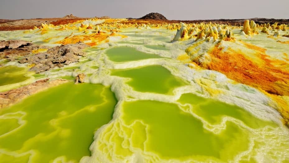
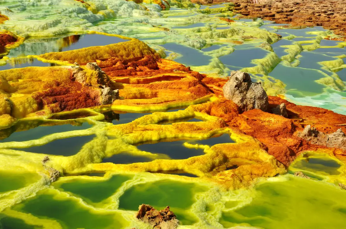
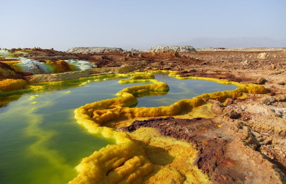
- Hydrothermal Activity: The Danakil Depression is a geologically active area with ongoing hydrothermal activity. Hydrothermal activity refers to the circulation of hot water or other fluids in the subsurface, which can result in the alteration and precipitation of minerals. In the Danakil Depression, hydrothermal activity is responsible for the formation of various mineral deposits, as well as the unique and colorful landscapes seen in areas such as Dallol, which is known for its hydrothermal springs and colorful mineral formations.
- Hot Springs and Fumaroles: The Danakil Depression is home to numerous hot springs and fumaroles, which are openings on the Earth’s surface that emit hot gases and steam. These hot springs and fumaroles are a result of the geothermal activity in the region, which is associated with the underlying tectonic processes and volcanic activity. The hot springs and fumaroles in the Danakil Depression often contain unique mineral formations, such as colorful salt formations, sulfur deposits, and other hydrothermal minerals.
- Mineral Extraction: The Danakil Depression is an important area for mineral extraction, with significant mining operations for potash and other minerals. Potash, in particular, is a key mineral extracted from the region, with Ethiopia being one of the world’s largest producers of potash. The mineral extraction activities in the Danakil Depression are driven by the unique geological characteristics of the area, including the presence of extensive salt deposits and hydrothermal activity.
- Mineralogical Research: The unique mineralogy of the Danakil Depression has also attracted considerable scientific research and study. Mineralogists and geologists from around the world visit the region to study the unique mineral formations, hydrothermal processes, and the geological history of the area. Research on the mineralogy of the Danakil Depression helps to advance our understanding of mineral formation processes, hydrothermal systems, and the geological evolution of the region.
In summary, the Danakil Depression is known for its rich mineralogy and hydrothermal activity, including the presence of economically valuable minerals, hot springs, fumaroles, and mineral extraction operations. The unique geology and hydrothermal processes in the region provide opportunities for mineralogical research and contribute to the geological significance of the Danakil Depression.

Volcanic Features
Volcanic features are important geological aspects of the Danakil Depression. The region has a history of volcanic activity, which has resulted in the formation of various volcanic features. Here are some key topics related to volcanic features in the Danakil Depression:
- Shield Volcanoes: The Danakil Depression is characterized by the presence of shield volcanoes, which are large, broad, and gently sloping volcanoes typically formed by the eruption of low-viscosity lava flows. These shield volcanoes in the Danakil Depression are associated with the underlying tectonic processes and the presence of extensive volcanic rocks, such as basalt. Shield volcanoes in the region include the Erta Ale volcano, which is known for its persistent lava lake, and the Dabbahu volcano, which erupted in 2005.
- Calderas: Calderas are large, circular depressions that form when a volcano collapses after a massive eruption. The Danakil Depression has several calderas, including the Asale Caldera, which is a large depression filled with salt and water, and the Dallol Caldera, which is known for its colorful hydrothermal springs and mineral formations.
- Tephra Deposits: Volcanic eruptions in the Danakil Depression have resulted in the deposition of tephra, which is the collective term for all the solid materials ejected during a volcanic eruption, including ash, lapilli, and volcanic bombs. Tephra deposits in the region provide important information about the past volcanic activity, eruption styles, and volcanic history of the area.
- Lava Flows: The eruption of lava from shield volcanoes in the Danakil Depression has resulted in the formation of extensive lava flows. These lava flows are composed of basaltic lava, which is low in viscosity and can travel long distances before solidifying. The lava flows in the region can create unique and rugged landscapes, with features such as lava tubes, lava channels, and lava deltas.
- Volcanic Cones: The Danakil Depression also contains several volcanic cones, which are small, steep-sided volcanoes formed by the eruption of viscous lava. These volcanic cones are typically characterized by their conical shape and often have craters at their summit. Volcanic cones in the region can provide insights into the types of eruptions that have occurred in the past and the nature of the volcanic activity in the area.
In summary, the Danakil Depression exhibits various volcanic features, including shield volcanoes, calderas, tephra deposits, lava flows, and volcanic cones. These volcanic features provide valuable information about the past and present volcanic activity in the region and contribute to the overall geologic significance of the Danakil Depression.

Human Interactions and Utilization of Resources
Human interactions and utilization of resources in the Danakil Depression are important topics related to the geology of the region. The unique geological features of the Danakil Depression have shaped human interactions and resource utilization in the area. Here are some potential outline topics related to this aspect:
- Salt Mining: The Danakil Depression is known for its vast salt deposits, which are believed to be among the largest in the world. Salt mining has been a significant human activity in the region for centuries, with local communities relying on salt extraction as a major source of income and livelihood. Topics related to salt mining in the Danakil Depression could include the methods and techniques used for salt extraction, the socio-economic impact of salt mining on local communities, and the environmental challenges associated with large-scale salt extraction.
- Geothermal Energy: The Danakil Depression is also characterized by extensive hydrothermal activity, including hot springs, fumaroles, and geysers. These geothermal resources have the potential for utilization as a source of renewable energy. Topics related to geothermal energy in the region could include the exploration and development of geothermal resources, the challenges and opportunities associated with geothermal energy production, and the potential environmental impacts of geothermal energy utilization in the Danakil Depression.
- Tourism and Cultural Interactions: The unique geological features of the Danakil Depression, such as the colorful hydrothermal springs, the salt flats, and the active volcanoes, have made the region a popular tourist destination. Topics related to tourism in the Danakil Depression could include the economic and social impact of tourism on local communities, the challenges and opportunities associated with tourism development, and the cultural interactions between tourists and local communities in the region.
- Environmental Challenges and Conservation Efforts: The Danakil Depression is known for its extreme environmental conditions, including high temperatures, aridity, and hypersaline environments. These environmental challenges pose unique conservation concerns for the region’s geological features, as well as its flora and fauna. Topics related to environmental challenges and conservation efforts in the Danakil Depression could include the impacts of human activities on the natural environment, conservation measures to protect the unique geological features and ecosystems of the region, and the role of local communities, governments, and NGOs in conservation efforts.
- Geological Research and Studies: The Danakil Depression offers a unique geological laboratory for scientific research and studies. Topics related to geological research and studies in the region could include the investigation of the region’s geologic history, tectonic processes, volcanic activity, mineralogy, and hydrothermal systems. Such research could contribute to our understanding of the geological processes and evolution of the Danakil Depression, as well as its significance in the broader context of geology and Earth sciences.
In summary, human interactions and utilization of resources in the Danakil Depression are important topics related to the geology of the region. Salt mining, geothermal energy, tourism, environmental challenges and conservation efforts, and geological research and studies are some potential outline topics that could be explored in more detail.
Summary of the key geological features and processes in the Danakil Depression
The Danakil Depression, located in Ethiopia, is a unique and extreme geological region that is characterized by a variety of key features and processes. Here is a summary of some of the main geological features and processes in the Danakil Depression:
- Rift Valley: The Danakil Depression is part of the larger East African Rift System, which is a divergent tectonic boundary where the African continent is splitting apart. This process has resulted in the formation of a rift valley, including the Danakil Depression, where the Earth’s crust is stretching and thinning, leading to the formation of faults, fractures, and grabens.
- Volcanic Activity: The Danakil Depression is known for its active volcanic features, including the Erta Ale volcano, which is one of the few continuously active lava lakes in the world. The region also has numerous other volcanic structures such as cinder cones, lava flows, and volcanic ash deposits, which are indicative of past and ongoing volcanic activity in the area.
- Hydrothermal Activity: The Danakil Depression is characterized by extensive hydrothermal activity, including hot springs, fumaroles, and geysers. These features are a result of the region’s geothermal energy and volcanic activity, with hot water and steam rising to the surface, creating unique and colorful hydrothermal features.
- Salt Deposits: The Danakil Depression is known for its vast salt deposits, which are believed to be among the largest in the world. The region has extensive salt flats, salt pans, and salt domes, resulting from the evaporation of ancient seas and the accumulation of salt over millions of years. Salt mining has been a significant human activity in the region for centuries, with local communities relying on salt extraction as a major source of income and livelihood.
- Extreme Environmental Conditions: The Danakil Depression is known for its extreme environmental conditions, including high temperatures, aridity, and hypersaline environments. The region experiences some of the highest average temperatures on Earth, with temperatures reaching over 50 degrees Celsius (122 degrees Fahrenheit) in some areas. The hypersaline environments, such as the salt pans and salt domes, also create unique ecological conditions, with specialized flora and fauna adapted to the extreme salinity.
- Geological Research and Studies: The Danakil Depression offers a unique geological laboratory for scientific research and studies. Researchers from various disciplines, including geology, volcanology, geochemistry, and geophysics, conduct studies in the region to better understand its geological history, tectonic processes, volcanic activity, mineralogy, and hydrothermal systems. Such research contributes to our understanding of the geological processes and evolution of the Danakil Depression, as well as its significance in the broader context of geology and Earth sciences.
In summary, the Danakil Depression is a unique geological region with key features and processes such as the rift valley, volcanic activity, hydrothermal activity, salt deposits, extreme environmental conditions, and opportunities for geological research and studies. These geological features and processes make the Danakil Depression a fascinating area for scientific inquiry and exploration.

Final thoughts on the geological significance and unique characteristics of this region
The Danakil Depression in Ethiopia is a remarkable geological region that holds great significance due to its unique characteristics and geological processes. From its location within the East African Rift System to its active volcanic features, extensive salt deposits, hydrothermal activity, extreme environmental conditions, and opportunities for scientific research, the Danakil Depression offers a wealth of geological significance.
One of the key aspects of the Danakil Depression’s geological significance is its role as a natural laboratory for studying tectonic processes and rift valley formation. The region provides an exceptional opportunity for researchers to study the processes of continental rifting and the associated geophysical, geochemical, and geological phenomena that occur as a result of the Earth’s crust pulling apart.
The active volcanic features of the Danakil Depression, including the continuously active lava lake at Erta Ale, offer a unique opportunity for studying ongoing volcanic processes and their impacts on the local geology, geomorphology, and environment. The region’s hydrothermal activity, characterized by hot springs, fumaroles, and geysers, provides insights into geothermal energy potential and the interactions between volcanic activity and hydrothermal systems.
The extensive salt deposits in the Danakil Depression are among the largest in the world and hold significance in terms of economic resources, as salt extraction has been a major human activity in the region for centuries. The hypersaline environments of the salt flats and salt domes also offer opportunities for studying unique ecological adaptations to extreme salinity and understanding the evolution of such environments.
The extreme environmental conditions of the Danakil Depression, including high temperatures, aridity, and hypersaline environments, make it a challenging yet fascinating area for studying extremophile organisms and their adaptations to extreme environments, as well as understanding the broader implications of such conditions for the Earth’s climate and ecosystems.
In conclusion, the Danakil Depression is a region of significant geological importance and unique characteristics. Its geological features, including the rift valley, volcanic activity, hydrothermal systems, salt deposits, extreme environmental conditions, and opportunities for scientific research, make it a remarkable area for studying various geological processes, understanding Earth’s history, and exploring the interactions between geology, environment, and human activities.


