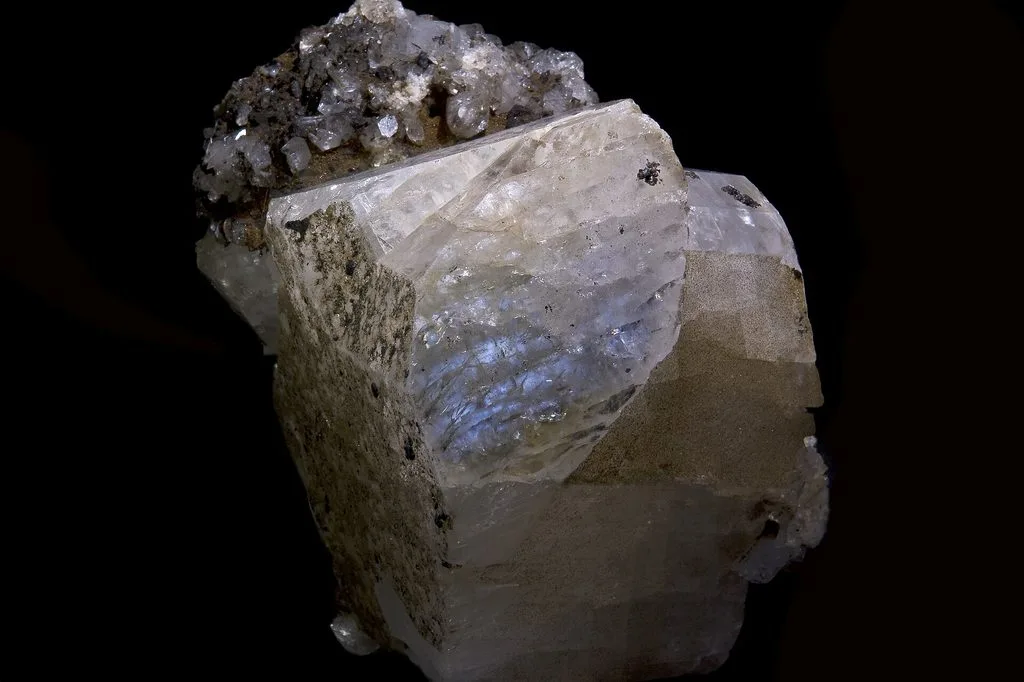
Home Blog Page 2

Epicenter vs Hypocenter: What’s the Difference?
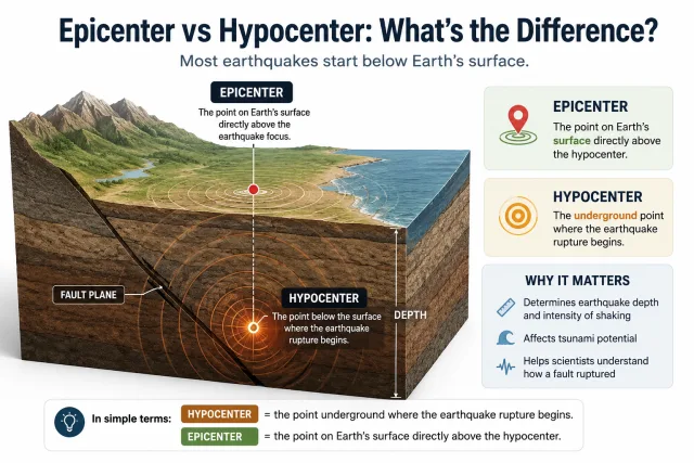
Epicenter vs hypocenter diagram showing the earthquake hypocenter below ground, the epicenter directly above it at the surface, fault plane, seismic waves, and focal depth

When an earthquake is reported, one of the first locations mentioned is usually the epicenter. It appears as a point on a map and is often described as the place where the earthquake occurred.

But an earthquake does not actually begin at the epicenter.

The rupture starts underground at a point called the hypocenter, also known as the earthquake focus. The epicenter is simply the point on Earth’s surface directly above that underground starting point.

In the simplest terms:

Hypocenter = where the earthquake rupture begins below the surface.

Epicenter = the point on the surface directly above the hypocenter.

The distinction is important because the depth and location of the hypocenter help scientists understand how an earthquake occurred, while the epicenter provides a convenient geographic reference on maps.

What Is the Hypocenter of an Earthquake?

The hypocenter is the point beneath Earth’s surface where fault rupture begins.

Stress can build along a fault for years, decades, or much longer. When the stress exceeds the strength of the rocks, part of the fault suddenly slips.

The first point where that rupture begins is the hypocenter.

Stored elastic energy is then released and travels outward as seismic waves, including P-waves, S-waves, and surface waves.

The term focus is also commonly used for the same location.

So:

hypocenter = earthquake focus

However, the hypocenter should not be confused with the entire earthquake rupture.

A major earthquake may begin at one point and then rupture tens or even hundreds of kilometers of a fault. The hypocenter marks only the starting point of that larger rupture.

What Is the Epicenter of an Earthquake?

The epicenter is the point on Earth’s surface directly above the hypocenter.

Imagine drawing a vertical line upward from the underground point where the earthquake begins. Where that line reaches the surface is the epicenter.

For example, if an earthquake starts 18 kilometers underground, its hypocenter is at a depth of 18 kilometers. The geographic point directly above it is the epicenter.

This is why earthquake reports often say things such as:

The epicenter was 25 kilometers east of a city.

The epicenter is easier to represent on a map than the three-dimensional position of the hypocenter.

But it is important to remember that the epicenter is a surface reference point, not the underground location where the fault rupture actually starts.

Epicenter vs Hypocenter: Key Differences

FeatureEpicenterHypocenter
LocationEarth’s surfaceBelow Earth’s surface
MeaningPoint directly above the hypocenterPoint where rupture begins
Other nameSurface reference pointEarthquake focus
Includes depth?NoYes
Commonly shown on maps?YesUsually shown in cross-sections or 3D models
RelationshipDirectly above hypocenterDirectly beneath epicenter
Represents entire rupture?NoNo, only the rupture starting point

The difference is therefore mainly one of depth and position.

The hypocenter exists inside Earth.

The epicenter is its surface projection.

How Deep Can an Earthquake Hypocenter Be?
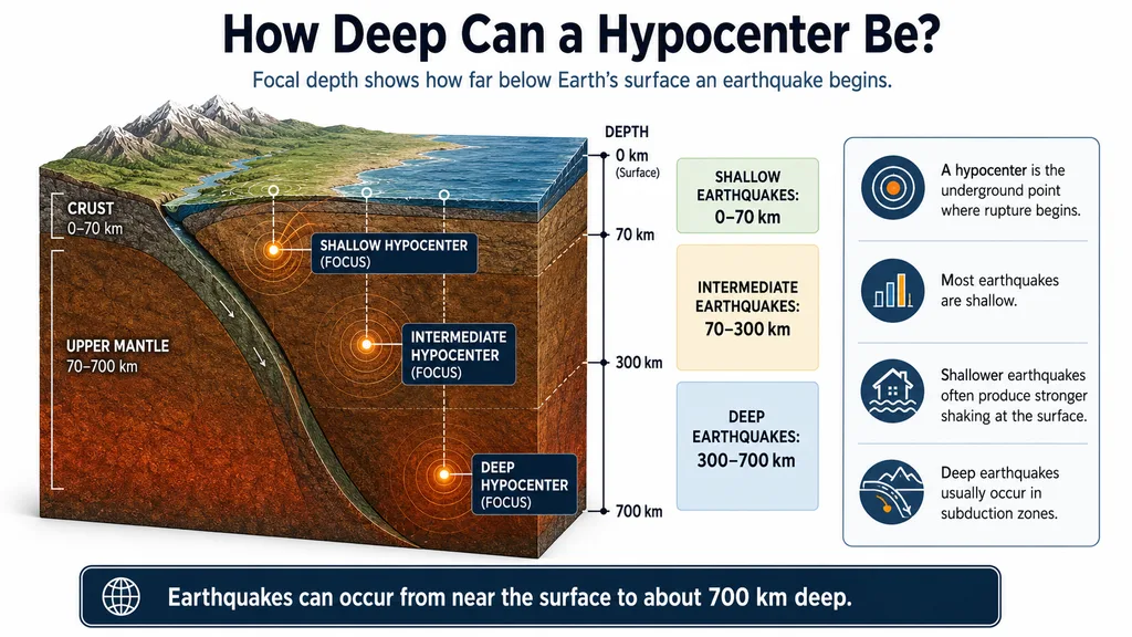
Focal depth diagram showing shallow, intermediate, and deep earthquake hypocenters from the surface to about 700 km depth

The distance between the hypocenter and Earth’s surface is called focal depth.

Earthquakes occur at very different depths, but they are commonly divided into three broad groups.

Shallow Earthquakes

Shallow-focus earthquakes occur at depths of about 0–70 kilometers.

Most earthquakes worldwide are shallow.

Many destructive earthquakes along continental faults also fall into this category because the rupture occurs relatively close to the surface.

Intermediate-Depth Earthquakes

Intermediate earthquakes occur at depths of roughly 70–300 kilometers.

They are especially associated with subduction zones, where one tectonic plate sinks beneath another.

Earthquakes can continue to occur within the descending plate as it moves deeper into the mantle.

Deep Earthquakes

Deep-focus earthquakes occur at approximately 300–700 kilometers depth.

They are mainly found inside deeply subducting slabs.

Earthquakes become extremely rare below about 700 kilometers because the high temperatures and pressures at greater depths make ordinary brittle failure increasingly difficult.

Why Does Earthquake Depth Matter?
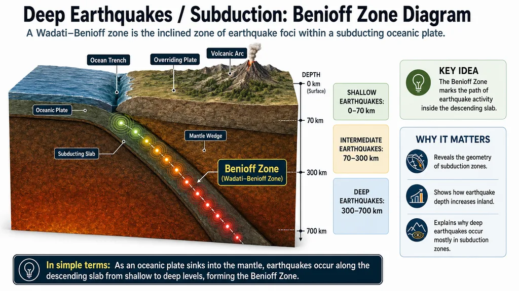
Benioff Zone diagram showing shallow, intermediate, and deep earthquakes along a subducting oceanic plate beneath an overriding plate

Focal depth can strongly influence how an earthquake is experienced at the surface.

A shallow earthquake releases energy relatively close to towns, roads, and buildings. Seismic waves therefore travel a shorter distance before reaching the surface.

This can contribute to intense shaking near the rupture.

A deeper earthquake may be felt across a much larger region, but the shaking near the surface can sometimes be weaker than that from a similar-magnitude shallow earthquake.

However, depth is only one part of the story.

Earthquake damage also depends on:

  • magnitude,
  • distance from the ruptured fault,
  • fault mechanism,
  • rupture direction,
  • local geology,
  • soil conditions,
  • building design and construction quality.

This is why two earthquakes with similar magnitudes can produce very different levels of damage.

Is the Epicenter Always Where the Strongest Shaking Occurs?

No.

This is one of the most common misconceptions about earthquakes.

The epicenter is simply the surface point directly above the hypocenter. It does not automatically mark the location of the strongest ground motion or greatest damage.

Large earthquakes can rupture very long sections of faults.

Suppose an earthquake begins at one end of a fault and then rupture travels 120 kilometers along it. A city 60 kilometers from the epicenter may actually lie much closer to another part of the ruptured fault.

That city could experience stronger shaking than a location directly at the epicenter.

Other factors can also change the pattern of shaking.

Rupture Directivity

A fault rupture can propagate preferentially in one direction, concentrating seismic energy toward certain areas.

Local Geology

Soft sedimentary basins can amplify seismic waves, while nearby areas built on competent bedrock may experience less amplification.

Distance to the Fault

For large earthquakes, distance to the actual rupture surface can sometimes matter more than distance to the epicenter.

So:

Epicenter does not mean “the most dangerous point.”

It is primarily a geographic reference.

How Do Scientists Find an Earthquake’s Epicenter and Hypocenter?

Scientists locate earthquakes using networks of seismic stations.

When an earthquake begins, several types of seismic waves travel outward.

P-waves move faster and normally reach a seismic station first.

S-waves travel more slowly and arrive later.

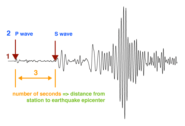
The difference between their arrival times is known as the S–P interval.

The greater the separation between the P- and S-wave arrivals, the farther the station generally is from the earthquake source.

A single station can estimate distance, but it cannot determine the complete location by itself.

Data from multiple seismic stations are therefore combined.

Modern earthquake-location systems use:

  • P-wave arrival times,
  • S-wave arrival times,
  • many seismic stations,
  • seismic velocity models,
  • computer-based inversion methods.

From these data, scientists estimate:

  • latitude,
  • longitude,
  • focal depth,
  • origin time.

The latitude and longitude define the epicenter.

Adding depth gives the full three-dimensional position of the hypocenter.

Why Does the Reported Epicenter or Depth Sometimes Change?

It is common for earthquake locations to be revised after the first report.

For example, an initial automatic solution may list:

Depth: 10 km

and later change to:

Depth: 16 km

The epicenter may also move by several kilometers.

This does not mean the earthquake itself moved.

The earliest earthquake solutions are often generated automatically using the seismic data available during the first minutes after the event.

As additional stations record the earthquake, scientists gain more information.

The solution can then be refined.

Another factor is the seismic velocity model.

Seismic waves do not travel at the same speed through every type of rock. Earth’s crust contains layers and structures with different physical properties.

Using a better model of those underground velocities can improve the estimated earthquake location.

Small revisions to an epicenter or hypocenter are therefore normal.

Does the Epicenter Identify the Fault That Ruptured?

Not necessarily.

If an epicenter lies close to a known active fault, that fault may be an obvious candidate.

But the epicenter alone is usually not enough to prove which fault moved, especially in regions where several faults are close together.

Scientists use additional evidence such as:

  • aftershock distribution,
  • focal mechanisms,
  • surface rupture,
  • GPS measurements,
  • satellite deformation,
  • seismic waveform analysis.

Aftershocks can be particularly useful.

If hundreds of aftershock hypocenters are plotted in three dimensions, their pattern can reveal the geometry of the fault that ruptured.

This can even expose faults that have little or no visible expression at the surface.

What Can Aftershock Hypocenters Tell Us?

After a large earthquake, smaller earthquakes often occur around the rupture zone.

These aftershocks do not appear randomly.

Their hypocenters can outline the underground fault structure.

When scientists plot them in three dimensions, they may reveal:

  • the angle of the fault,
  • the depth range of rupture,
  • the length of the activated fault zone,
  • nearby faults that were also stressed.

This is one reason hypocenter information is so valuable.

An epicenter provides a location on a map.

A collection of hypocenters can reveal the hidden geometry of an entire fault system beneath the surface.

Can an Epicenter Be in the Ocean?

Yes.

Many of Earth’s major plate boundaries lie beneath the oceans, so offshore earthquakes are extremely common.

Some of the world’s largest earthquakes occur along underwater subduction zones.

An offshore epicenter, however, does not automatically mean a tsunami will occur.

Tsunami generation depends on several factors, including:

  • earthquake magnitude,
  • focal depth,
  • fault type,
  • amount and direction of seafloor displacement.

Large, shallow earthquakes that produce significant vertical movement of the seafloor are the most important tsunami-generating events.

A deep earthquake or one involving mainly horizontal fault movement may produce little or no tsunami even if its epicenter is offshore.

Epicenter, Hypocenter and Fault: What’s the Difference?
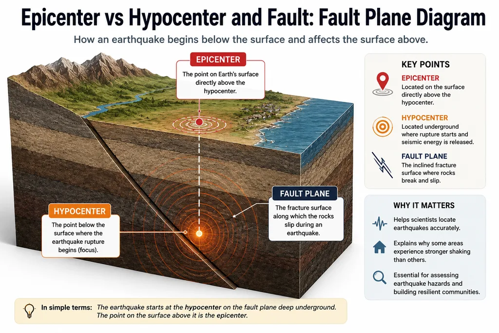
Fault plane diagram showing the hypocenter where earthquake rupture begins, the epicenter directly above it, and the inclined fault surface where rocks slip

These three terms describe different parts of the earthquake process.

Hypocenter:
The underground point where rupture begins.

Epicenter:
The surface point directly above the hypocenter.

Fault:
The fracture or fracture zone along which rock masses move.

A fault may extend for hundreds of kilometers.

The hypocenter is just one point on that fault where a particular earthquake begins.

After rupture starts, it can spread across a much larger section of the fault.

This is why a large earthquake cannot be understood simply by looking at its epicenter.

A Simple Example

Imagine an earthquake begins 12 kilometers below Earth’s surface.

The underground starting point is the:

Hypocenter

The point directly above it is the:

Epicenter

Now suppose the rupture spreads eastward along 80 kilometers of fault.

A city 40 kilometers from the epicenter happens to sit directly beside the ruptured fault and on thick, soft sediments.

Another town lies almost directly at the epicenter but is built on solid bedrock.

The city farther from the epicenter could experience stronger shaking and greater damage.

The example shows why earthquake effects depend on much more than the position of a single dot on a map.

Why Are Epicenter and Hypocenter Important?

The epicenter is useful because it gives the public and scientists an immediate geographic reference for an earthquake.

The hypocenter provides additional information that is essential for understanding the earthquake itself.

Its depth can help reveal the tectonic environment.

A cluster of hypocenters can show the shape of a hidden fault.

Changes in hypocenter distribution can reveal where aftershocks are occurring.

Together, epicenter and hypocenter information help scientists understand earthquakes in three dimensions rather than treating them as isolated points on a map.

Frequently Asked Questions

Is the hypocenter the same as the focus?

Yes. Hypocenter and earthquake focus generally mean the same thing: the point below Earth’s surface where the rupture begins.

Does an earthquake start at the epicenter?

No. It begins at the hypocenter underground. The epicenter is the point on the surface directly above it.

Is the epicenter always where earthquake damage is greatest?

No. Damage depends on the full fault rupture, distance, local geology, soil conditions, rupture direction, and the vulnerability of buildings.

How deep can an earthquake hypocenter be?

Most earthquakes are shallow, but earthquakes in subduction zones can occur hundreds of kilometers below the surface. The deepest earthquakes reach depths close to 700 kilometers.

Why can shallow earthquakes be more damaging?

Their rupture occurs closer to the surface, so strong seismic energy can reach nearby communities over a shorter distance. Magnitude, geology, distance to the fault, and building quality are also important.

Can an earthquake have more than one epicenter?

A standard earthquake location has one hypocenter and one corresponding epicenter. However, a large earthquake can rupture a very large fault area, so the epicenter does not represent the entire rupture.

Why does an earthquake’s epicenter sometimes change after the first report?

Early locations are often automatic estimates based on limited data. As more seismic records become available, the epicenter and focal depth can be refined.

Can an earthquake epicenter be underwater?

Yes. Many earthquakes occur beneath oceans, especially along mid-ocean ridges and subduction zones.

Final Thoughts

The difference between an epicenter and a hypocenter is simple but important.

The hypocenter is the underground point where an earthquake rupture begins.

The epicenter is the location on Earth’s surface directly above it.

But neither point represents the entire earthquake.

Large ruptures can spread across tens or hundreds of kilometers of fault, and the strongest shaking does not necessarily occur at the epicenter.

The hypocenter adds another crucial dimension: depth.

Knowing where a rupture begins beneath the surface helps scientists understand earthquake behavior, map hidden faults, interpret aftershock patterns, and identify the tectonic processes responsible.

So when an earthquake map shows a single dot labeled epicenter, that dot is only the surface reference.

The earthquake itself began somewhere below it.
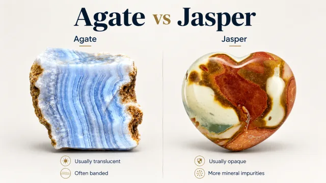
Agate vs Jasper: What’s the Difference?

Agate vs jasper comparison showing the translucent banding of agate and the opaque, impurity-rich appearance of jasper.

Agate and jasper can look like completely different stones at first glance. Agate is often recognized by its translucent appearance, colorful bands, and ability to transmit light, while jasper is usually opaque, strongly colored, and sometimes filled with patterns that resemble landscapes.

Mineralogically, however, they are much more closely related than they appear.

Both are composed mainly of extremely fine-grained silica and are commonly grouped with chalcedony and other microcrystalline quartz materials. One of the most useful differences between them is usually how much light they transmit.

In the simplest terms:

Agate is usually translucent and commonly displays distinct banding.

Jasper is usually opaque and often contains more iron oxides, clay minerals, and other impurities that produce stronger colors.

But nature does not always create a perfect boundary between the two.

Some specimens may contain translucent areas that look like agate alongside opaque areas that resemble jasper. This is why rock collectors sometimes have difficulty deciding whether a specimen should be called agate, jasper, or something between the two.

So how can you tell them apart? Does holding the stone up to a light really work? Is every banded stone an agate? Why is jasper opaque? And can one stone contain both agate and jasper?

What Is Agate?

Natural agate showing distinctive translucent bands and layered silica

Agate is a variety of chalcedony composed mainly of extremely fine-grained silica.

Its most characteristic feature is banding.

When an agate is cut or polished, it may reveal:

  • parallel bands,
  • wavy lines,
  • concentric rings,
  • thin layers of different colors.

Agates commonly form when silica-rich fluids enter cavities in rocks and silica gradually precipitates along the walls.

Gas cavities in volcanic rocks are especially favorable places for agate formation.

When lava cools, gas bubbles can leave open spaces within the rock. Later, groundwater or hydrothermal fluids carrying dissolved silica can move through these cavities.

Silica begins to deposit on the cavity walls.

As additional fluids arrive, new layers can form.

Over time, repeated episodes of silica deposition may produce the characteristic bands seen inside many agate nodules.

This also explains why an agate nodule can look like an ordinary rock on the outside but reveal complex patterns when cut open.

Agate is commonly described as a banded form of chalcedony, and research shows that it consists mainly of fibrous microcrystalline quartz, often with moganite and other silica phases.

What Is Jasper?

Natural unpolished jasper showing its dense opaque appearance

Jasper is also composed mainly of very fine-grained silica, but it is generally distinguished from agate by being opaque.

Its opacity is largely caused by abundant microscopic impurities and mineral inclusions.

These may include:

  • iron oxides,
  • iron hydroxides,
  • clay minerals,
  • hematite,
  • goethite,
  • manganese-bearing compounds.

These additional materials prevent light from passing easily through the stone and also give jasper its wide range of colors.

For example:

Red jasper commonly owes its color to iron oxides such as hematite.

Yellow and brown varieties can contain different iron-bearing minerals or oxidation products.

Green colors can be produced by other mineral inclusions.

Jasper may occur as a nearly uniform color, but it can also display highly complex patterns.

This has led to many trade and lapidary names such as picture jasper, brecciated jasper, ocean jasper, and numerous locality-specific varieties.

Mineralogical references generally describe jasper as opaque to slightly translucent, impure microcrystalline silica containing abundant fine mineral inclusions.

Agate vs Jasper: Key Differences

FeatureAgateJasper
Main materialMicrocrystalline silica / chalcedonyMicrocrystalline silica with more impurities
TransparencyUsually translucentUsually opaque
BandingVery commonMay occur but is less diagnostic
Typical appearanceLayered, banded, translucentDense, opaque, patterned or solid-colored
Common colorsWhite, gray, blue, red, brown, orangeRed, yellow, brown, green, black
Main cause of colorTrace elements and microscopic inclusionsOften abundant iron oxides and other impurities
Mohs hardnessAbout 6.5–7About 6.5–7
Common identification clueLight often passes through thin edgesUsually blocks transmitted light

This table shows the general difference, but natural specimens do not always fit perfectly into these categories.

How Can You Tell Agate from Jasper?

One of the easiest home tests is simply to hold the stone against a strong light.

Even the flashlight on a phone can be useful for an initial inspection.

Hold the Stone Up to a Light

Agate will often transmit at least some light, especially around thin edges.

A thick piece of agate may not look obviously translucent, but its thinner areas can become illuminated when a strong light is placed behind it.
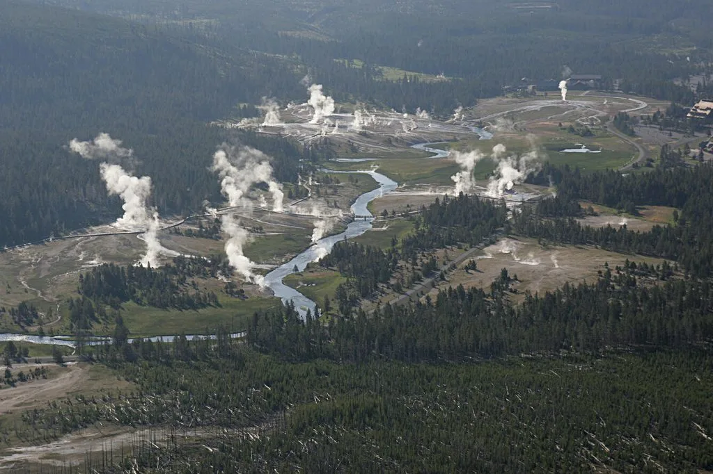
Jasper usually blocks the light.

Even with a bright flashlight directly behind the stone, most jasper remains opaque.

As a simple first clue:

Translucent → more likely agate

Opaque → more likely jasper

This is also consistent with common gemological distinctions between translucent, banded agate and opaque jasper.

However, this is not an absolute test.

A very thick agate can also appear opaque, so thin edges are usually the best areas to examine.

Is Banding Always a Sign of Agate?

No.

Banding is one of the most recognizable features of agate, but:

Not every banded stone is agate.

Jasper and other rocks can also develop layered or banded patterns.

Sedimentary layering, fractures, mineral alteration, and changing oxidation conditions can all create lines or bands in opaque rocks.

The important difference is not simply whether bands exist, but what those bands represent.

Agate commonly develops fine layers produced by successive stages of chalcedony and silica deposition.

In many nodules, the bands follow the shape of the cavity and form concentric or irregular rings.

Jasper patterns are often more irregular, massive, mottled, or strongly colored.

Agate itself can show several different types of banding, including concentric wall-lining bands and parallel layers.

Why Is Agate Translucent but Jasper Opaque?

This question gets to the heart of the difference between agate and jasper.

Although both consist mainly of silica, jasper commonly contains much more microscopic foreign material.

When light enters a stone, it interacts with crystals, inclusions, pores, and mineral particles.

In relatively clean areas of agate, the microcrystalline structure may allow part of the light to pass through.

The stone therefore appears translucent.

Jasper commonly contains more:

  • iron oxides,
  • clay-sized particles,
  • mineral inclusions,
  • microscopic impurities.

These materials scatter or absorb light strongly.

The result is an opaque stone.

That is why transparency is often much more useful than color when trying to distinguish agate from jasper.

Are Agate and Jasper Both Quartz?

The answer is often simplified to “yes,” but it deserves some explanation.

Both agate and jasper consist largely of silica, SiO₂.

However, they are not normally made of large, visible quartz crystals like those found in a typical crystal cluster.

Instead, the silica occurs as microscopic or submicroscopic crystalline material.

Agate is commonly classified as a variety of chalcedony, which is itself a microcrystalline form of silica.

Jasper is also generally treated as an opaque microcrystalline silica material, although geological and lapidary terminology is not always perfectly consistent.

This close relationship also explains why their hardness is very similar.

Both usually have a Mohs hardness of approximately:

6.5–7

So a hardness test is not especially useful for distinguishing agate from jasper.

Can a Stone Be Both Agate and Jasper?

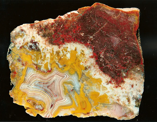
Agate jasper specimen showing translucent chalcedony and opaque jasper in the same stone

Yes.

Nature does not have to follow the categories humans create.

A single specimen can contain a translucent, banded region resembling agate and another opaque region resembling jasper.

Materials showing this transition are sometimes called:

jasp-agate

or

jaspagate.

These mixed textures can form when silica-rich fluids fill the same rock cavity or fracture under changing chemical conditions.

For example, one stage may deposit relatively clean chalcedony.

A later stage may introduce more iron oxides or other impurities.

The result can be a single specimen containing both translucent and opaque silica-rich zones.

This is why some specimens cannot be classified neatly as only agate or only jasper.

What Is Jaspagate?

Jaspagate is a practical term used for siliceous material that displays characteristics of both jasper and agate.

A specimen may contain:

  • translucent zones,
  • opaque zones,
  • agate-like bands,
  • jasper-like strongly colored areas.

Jaspagate is not a separate mineral species.

The name is used to describe material that falls between the two traditional appearance-based categories.

For collectors, these specimens can be particularly attractive because a single polished surface may display very different textures.

Is Jasper a Type of Agate?

Usually, no.

Agate and jasper are closely related silica-rich materials, but they are normally treated as separate varieties in gemological and lapidary terminology.

Agate is characteristically translucent and commonly banded.

Jasper is characteristically opaque and commonly contains more mineral impurities.

However, there is no perfectly sharp boundary in nature.

So it would also be misleading to imagine agate and jasper as two completely unrelated minerals.

They are closely related microcrystalline silica materials that differ mainly in texture, transparency, and impurity content.

Why Does Jasper Have So Many Colors?

One of the most attractive characteristics of jasper is its enormous variety of colors.

Pure silica alone does not normally produce the strong reds, yellows, browns, and greens seen in many jasper specimens.

Much of the color comes from other minerals and microscopic inclusions.

Red Jasper

Red coloration is commonly associated with hematite and other iron oxides.

Yellow Jasper

Yellow to yellow-brown colors can be associated with iron hydroxides and other weathering or oxidation products.

Brown Jasper

Brown colors can result from combinations of iron oxides and other impurities.

Green Jasper

Green varieties may contain different iron-bearing or other coloring minerals.

These inclusions do more than create color.

They can also help make the material opaque.

Mindat notes that jasper commonly contains abundant fine inclusions of hematite, iron hydroxides, and other minerals.

Why Does Agate Have Bands?

Agate banding is closely related to the way the material grows.

When silica-rich fluids enter a cavity, chalcedony can begin to precipitate on the cavity walls.

The process does not necessarily happen all at once.

Different episodes of fluid movement may bring:

  • different silica concentrations,
  • trace elements,
  • different chemical conditions,
  • different mineral impurities.

Each period of growth can produce another layer.

This can result in extremely fine white, gray, red, brown, orange, or other colored bands when the agate is cut.

Some nodules contain hundreds of visible layers.

Changes in crystal size, porosity, transparency, and mineral inclusions can all contribute to the appearance of agate banding.

The exact mechanism responsible for all forms of agate banding remains complex, and multiple formation models have been proposed.

Where Do Agate and Jasper Form?

Agate and jasper can occur in several geological environments.

Agate Formation

Agate is especially well known from volcanic rocks.

As basaltic and other lavas cool, gas bubbles can leave cavities in the rock.

Silica-rich groundwater or hydrothermal fluids can later enter those cavities.

Silica gradually precipitates along the walls, sometimes forming concentric layers.

Over time, the cavity may become partly or completely filled with chalcedony, agate, and sometimes crystalline quartz.

Agates are particularly common in cavities within volcanic rocks, although they also occur in sedimentary and hydrothermal environments.

Jasper Formation

Jasper can form in several geological settings.

Silica-rich sediments, hydrothermal activity, replacement processes, and silicification can all contribute to its formation.

Some jasper is associated with ancient marine sediments and iron-rich geological environments.

Jasper is particularly well known in association with some banded iron formations, where silica and iron-rich materials accumulated in ancient sedimentary systems.

This variety of geological settings helps explain why jasper occurs in so many different colors and patterns.

Agate vs Jasper: Which Is More Valuable?

There is no single answer.

Neither agate nor jasper is generally rare as a broad material category.

Value depends much more on the quality and appearance of the individual specimen.

For agate, desirable features may include:

  • sharp and attractive banding,
  • unusual colors,
  • strong contrast,
  • large intact nodules,
  • rare patterns,
  • famous localities.

For jasper, value may increase with:

  • unusual patterns,
  • attractive color combinations,
  • rare localities,
  • large high-quality pieces,
  • strong lapidary potential.

Some named varieties of both agate and jasper can sell for much higher prices than ordinary material.

So there is no general rule that:

agate is always more valuable than jasper

or the opposite.

Can You Tell Agate from Jasper by Hardness?

Usually not.

Because both consist largely of silica, their Mohs hardness values are very similar.

Agate:

about 6.5–7

Jasper:

about 6.5–7

Both can be harder than many common steel objects and may scratch glass.

So a hardness test can help answer:

“Is this likely a quartz-rich material?”

But it usually cannot answer:

“Is this agate or jasper?”

Transparency, internal texture, and banding are more useful characteristics.

Agate itself is commonly listed with a hardness of about 6.5–7.

What About Carnelian? Is It Agate or Jasper?

Carnelian is another member of the chalcedony family and typically has red, orange, or brownish coloration.

Its translucency helps separate it from most jasper.

A red chalcedony specimen that allows light to pass through may be described as carnelian.

A similar red microcrystalline silica material that is completely opaque is more likely to be called jasper.

However, trade names and mineralogical classifications do not always match perfectly.

Color alone is therefore not enough for identification.

How to Identify Agate and Jasper in the Field

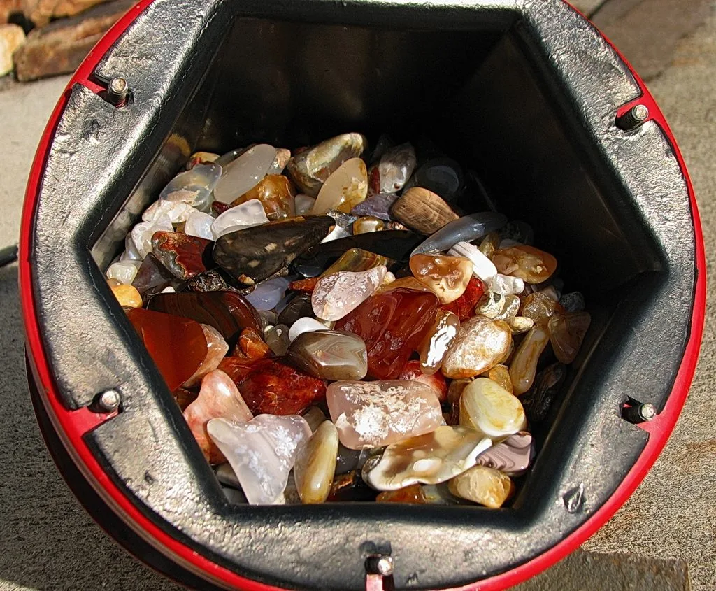
Tumbled agate and jasper stones showing differences in translucency color and pattern

When you find a silica-rich rock, examine broken surfaces and thin edges before relying on color alone.

For Agate, Look For:

  • translucency,
  • fine banding,
  • concentric layers,
  • waxy luster,
  • cavity-filling shapes.

For Jasper, Look For:

  • opaque appearance,
  • dense red, yellow, brown, or green coloration,
  • irregular patterns,
  • conchoidal fracture,
  • fine-grained texture.

The exterior can be misleading.

Agate nodules may look like ordinary gray or brown rocks before they are cut.

The most interesting structure can remain completely hidden inside.

Frequently Asked Questions

What is the easiest way to tell agate from jasper?

Holding the stone against a strong light is a useful first test. Agate is commonly translucent, especially along thin edges, while jasper is usually opaque.

Is every banded stone an agate?

No. Banding is characteristic of many agates, but jasper and other rocks can also display layered or banded patterns.

Is jasper a type of quartz?

Jasper is composed mainly of microcrystalline silica and is closely related to the quartz-chalcedony family.

Is agate harder than jasper?

Usually not by any useful amount. Both are generally around 6.5–7 on the Mohs hardness scale.

Can agate and jasper occur in the same stone?

Yes. A specimen can contain both translucent agate-like and opaque jasper-like areas. Such material is sometimes called jaspagate.

Why is jasper opaque?

Jasper commonly contains abundant microscopic mineral impurities, including iron oxides and other inclusions that scatter or absorb light.

Why is agate translucent?

Some agate contains sufficiently clean and fine-grained silica structures to allow part of the light to pass through.

Which is more valuable, agate or jasper?

Value depends on pattern, color, size, quality, rarity, and locality. Neither material is automatically more valuable than the other.

Can I identify agate or jasper from a photo?

Sometimes patterns provide useful clues, but photographs cannot reliably show all important features, especially how much light passes through the stone.

Final Thoughts

The difference between agate and jasper may seem to be mainly about color and pattern.

In practice, one of the most useful distinctions is transparency.

Agate is generally translucent and often displays fine, regular, or concentric banding.

Jasper is usually opaque because it contains more mineral impurities and can develop intense red, yellow, brown, green, or multicolored patterns.

Mineralogically, however, they are not completely different materials.

Both are dominated by microcrystalline silica and are closely associated with the chalcedony–quartz family.

That close relationship explains why the boundary between them can sometimes become blurred.

One part of a specimen may transmit light like agate while another part is completely opaque like jasper.

So when trying to identify an unknown specimen, do not begin with color alone.

Start by asking a simpler question:

What happens when you hold the stone up to the light?

In many cases, that is where the most useful difference between agate and jasper becomes visible.

References

  • Gemological Institute of America (GIA), Structures Behind the Spectacle: A Review of Optical Effects in Phenomenal Gemstones and Their Underlying Nanotextures — discussion of agate as banded chalcedony, its microcrystalline silica structure, and formation in volcanic cavities.
  • Gemological Institute of America (GIA), Agates from Sidi Rahal, in the Atlas Mountains of Morocco: Gemological Characteristics and Proposed Origin — agate composition, silica-rich fluids, band development, and mineral inclusions.
  • Mindat.org, Agate: Mineral Information, Data and Localities — agate composition, hardness, translucency, banding, and geological occurrence.
  • Mindat.org, Jasper: Mineral Information, Data and Localities — definition of jasper as opaque to slightly translucent impure microcrystalline silica and information on common mineral inclusions.
  • Geology.com, Agate Gemstones — agate as translucent microcrystalline quartz and its formation by silica deposition in cavities within igneous rocks.
  • Geology.com, Flint, Chert, and Jasper: Names for Microcrystalline Quartz — practical distinction between translucent banded agate and opaque jasper and discussion of microcrystalline quartz terminology.

P-Waves vs S-Waves: What’s the Difference?

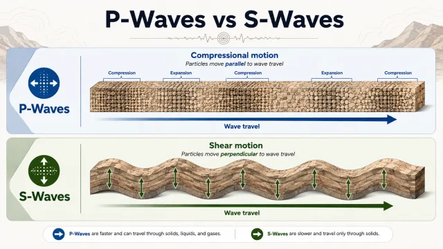
P-waves vs S-waves diagram showing compressional and shear wave motion

When an earthquake occurs, the ground does not shake in just one way. The energy released at the earthquake source travels through and along the Earth as different types of waves. Two of the most important are P-waves and S-waves.

When a seismometer begins recording an earthquake, the first signal to arrive is usually the P-wave. A little later, the slower-moving S-wave arrives. If you are far enough from the earthquake source, this difference can sometimes even be felt by people: first a light, short vibration, followed by stronger shaking.

But the difference between P- and S-waves is not only about which one arrives first.

P-waves can travel through solids as well as liquids, while S-waves cannot travel through liquids. This apparently simple property provided one of the most important pieces of evidence that helped scientists understand that Earth’s outer core, thousands of kilometers beneath our feet, is liquid.

The same waves are still used today to locate earthquakes, study the internal structure of Earth, and operate earthquake early warning systems.

So what exactly are P- and S-waves? Which one is faster? Which one causes more damage? And why can’t S-waves travel through liquids?

What Are P-Waves and S-Waves?

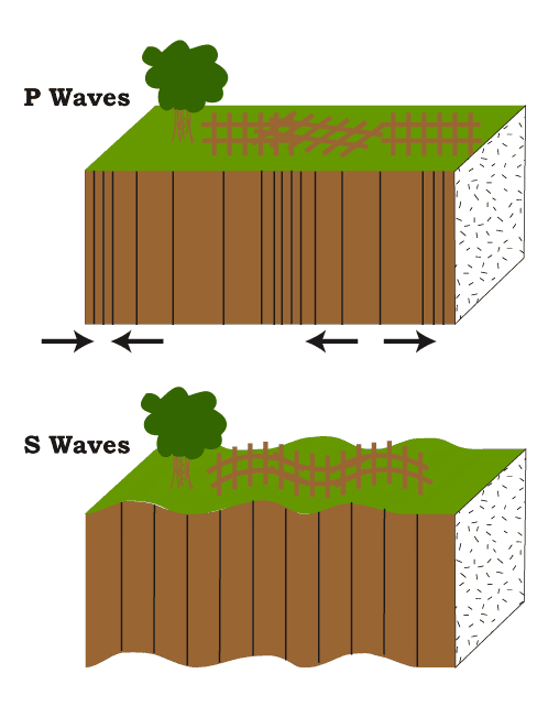
P Waves alternately compress and stretch the crustal material parallel to the direction they are propagating. S Waves cause the crustal material to move back and forth perpendicular to the direction they are travelling.

P- and S-waves are classified as body waves, meaning seismic waves that travel through the interior of the Earth.

This means they do not move only along Earth’s surface. They can pass through rock and travel deep into the planet.

When a fault suddenly ruptures during an earthquake, a large amount of stored elastic energy is released. This energy is transferred into the surrounding rocks and produces different types of seismic waves.

The P in P-wave stands for Primary.

The S in S-wave stands for Secondary.

The reason for these names is simple:

P-waves reach a seismic station first.
S-waves arrive later.

However, the way they move through material is completely different.

P-Waves vs S-Waves: Key Differences

FeatureP-WavesS-Waves
Full namePrimary WavesSecondary Waves
Arrival at seismic stationFirstAfter P-waves
SpeedFasterSlower
Particle motionCompression and expansionShearing motion
Travel through solidsYesYes
Travel through liquidsYesNo
Travel through gasesYesNo
Wave typeLongitudinal / compressionalTransverse / shear
Typical shakingUsually weakerOften stronger
Importance for studying Earth’s interiorVery highVery high

The table shows the basic differences between the two waves, but the most interesting part is understanding why these differences exist.

What Are P-Waves?

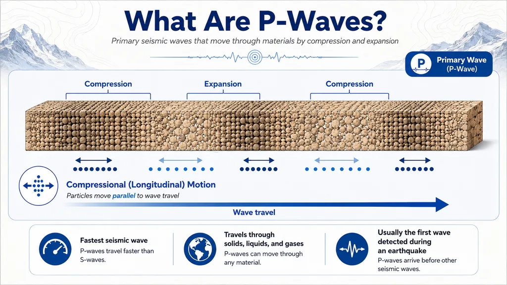
P-wave diagram showing compression and expansion as particles move parallel to the direction of wave travel

P-waves are the fastest seismic waves produced during an earthquake.

For this reason, they are usually the first seismic waves detected by a seismometer.

As P-waves travel, they move rock particles backward and forward in the same direction that the wave itself is traveling.

You can imagine this by thinking about a spring.

If you compress one end of a spring and release it, the compressed section travels through the spring. The entire spring does not move from one end to the other; instead, energy moves through repeated compression and expansion.

P-waves behave in a similar way.

The rock is briefly:

compressed → expanded → compressed again.

For this reason, P-waves are also called compressional waves.

The way sound waves travel through air is based on a similar principle.

How Fast Do P-Waves Travel?

P-waves do not have one fixed speed.

Their velocity depends on the material they are traveling through, including its:

  • density,
  • elastic properties,
  • pressure,
  • temperature,
  • mineral composition.

Within Earth’s crust, P-waves commonly travel through rock at approximately 5–8 kilometers per second.

Their speed can increase in the deeper and denser parts of the mantle.

That is extremely fast.

A P-wave traveling at 6 kilometers per second can cover about 60 kilometers in only 10 seconds.

However, P-wave velocity does not remain constant throughout Earth. As the waves pass between layers with different densities and compositions, they can refract, reflect, and change speed.

This is one of the reasons scientists can use seismic waves to investigate Earth’s internal structure.

What Does a P-Wave Feel Like During an Earthquake?

Depending on the distance from the earthquake source and the local geology, a P-wave may feel like a short jolt or a light vibration.

Some people describe large earthquakes by saying:

“First there was a small shake, then a few seconds later the strong shaking started.”

This does not always mean that the person distinctly felt the P- and S-waves. Local geology, building response, and other seismic waves can change how an earthquake feels.

However, when a person is far enough from the earthquake source, the difference between P- and S-wave arrival times can become noticeable.

This time difference is also one of the principles behind earthquake early warning systems.

What Are S-Waves?

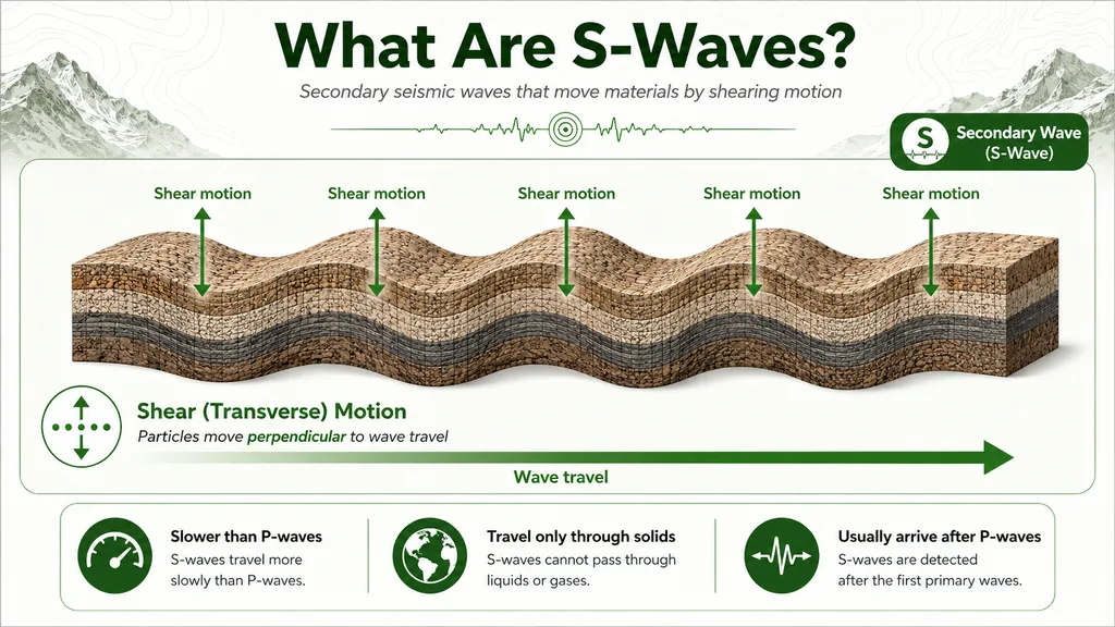
S-wave diagram showing shear motion as particles move perpendicular to the direction of wave travel

S-waves are the second major type of body wave and travel more slowly than P-waves.

Their movement, however, is completely different.

While P-waves compress and expand the material in the direction they travel, S-waves move particles perpendicular to the direction of wave travel.

For example, if the wave is moving eastward, the rock particles may move upward and downward or from side to side.

For this reason, S-waves are also called shear waves.

S-waves can often produce stronger ground motion than P-waves. However, it would be incorrect to say that S-waves always cause the greatest earthquake damage. Surface waves, especially Love and Rayleigh waves, can create stronger and longer-lasting motion during large earthquakes.

Why Can’t S-Waves Travel Through Liquids?

This is probably the most important difference between P- and S-waves.

P-waves can travel through:

solids + liquids + gases

S-waves, however, can only travel through materials capable of supporting shear stress.

The reason is that an S-wave requires the material to resist sideways deformation.

If you push part of a solid rock sideways, the rock resists the deformation and can transfer the force to neighboring material.

A liquid does not behave in the same way.

When one part of a liquid is pushed sideways, the liquid flows and changes shape. It cannot maintain shear stress in the way a solid can.

For this reason, liquids have essentially no shear rigidity for seismic-wave propagation, and S-waves cannot travel through them.

This property became extremely important for understanding the structure of Earth.

Which Is Faster: P-Waves or S-Waves?

P-waves are faster.

That is why they are called “Primary Waves.”

Within the same rock, a P-wave always travels faster than an S-wave.

For example, in a material where a P-wave travels at around 6 kilometers per second, an S-wave might travel at roughly 3–4 kilometers per second.

As the distance from the earthquake source increases, the difference between their arrival times becomes larger.

Close to the earthquake source, the P- and S-waves may arrive only a few seconds apart.

Hundreds of kilometers away, the difference can become much larger.

Seismologists use this difference to estimate how far an earthquake source is from a seismic station.

What Is the S–P Time Interval?

Seismogram showing the arrival of P-waves and S-waves during an earthquake

On a seismogram, the P-wave arrives first.

The S-wave follows later.

The difference between these arrival times is known as the S–P interval.

For example:

If the P-wave arrives at 10:00:00,

and the S-wave arrives at 10:00:20,

the S–P interval is about 20 seconds.

In general, the larger this interval is, the farther the earthquake source is from the station.

A single station cannot precisely determine the direction of the earthquake source. But when data from seismic stations in different locations are combined, the earthquake location can be calculated with high accuracy.

This is often explained using simple examples with three stations and geometric triangulation.

Modern seismology, however, uses data from many more stations and combines P- and S-wave arrival times with computer models and inverse methods.

Which Causes More Damage: P-Waves or S-Waves?

In general, S-waves can produce stronger shaking than P-waves.

This is partly because their shearing movement can force structures through stronger horizontal or vertical motions.

However, the statement:

“S-waves cause the most earthquake damage”

is not always correct.

Surface waves can become much more important during large earthquakes.

In particular:

Love waves
and
Rayleigh waves

travel near Earth’s surface and can create large-amplitude ground motion.

Rayleigh waves can move the ground in an elliptical rolling motion, somewhat similar to ocean waves.

Love waves create strong horizontal side-to-side motion.

For this reason, surface waves may be responsible for a significant part of the structural damage during major earthquakes.

P-Waves vs S-Waves vs Surface Waves

It is useful to divide the main seismic waves into three basic groups.

P-Waves

They are the fastest.

They travel through Earth’s interior.

They can pass through solids, liquids, and gases.

S-Waves

They are slower than P-waves.

They also travel through Earth’s interior.

They can only travel through solids.

Surface Waves

They travel close to Earth’s surface.

They are generally slower than P- and S-waves.

However, they can have large amplitudes and may cause severe damage in populated areas.

A simplified arrival order during an earthquake can therefore be written as:

P → S → surface waves

Real seismograms are more complicated. As seismic waves interact with boundaries inside Earth, they can reflect, refract, and produce many different seismic phases.

How Did P- and S-Waves Reveal Earth’s Internal Structure?

One of the most impressive uses of seismic waves is that they allow us to investigate parts of Earth that humans have never physically reached.

The deepest boreholes ever drilled are tiny compared with Earth’s radius.

The distance from Earth’s surface to its center is about 6,371 kilometers.

Yet scientists know a great deal about:

  • the crust,
  • the mantle,
  • the outer core,
  • the inner core.

One of the main reasons is seismic waves.

In a sense, large earthquakes create a natural ultrasound of the planet.

Scientists study which seismic waves reach different stations, where they disappear, where their speeds change, and how they bend as they travel through Earth.

From these observations, they can infer what exists deep beneath the surface.

How Did S-Waves Show That Earth’s Outer Core Is Liquid?

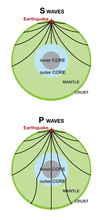
P-wave and S-wave paths through Earth showing the liquid outer core

When a large earthquake occurs, S-waves can travel through Earth’s mantle.

But when they reach the boundary of the outer core, something changes.

The outer core is liquid.

Because S-waves cannot travel through liquids, they do not pass through the outer core.

As a result, there are regions on the opposite side of Earth where direct S-waves are not recorded.

This region is known as the S-wave shadow zone.

This observation led scientists to an important conclusion.

If the entire Earth were solid, S-waves should have been able to continue through the core.

But they did not.

This became one of the strongest seismic pieces of evidence that Earth’s outer core is liquid.

What Is the P-Wave Shadow Zone?

The situation with P-waves is different.

P-waves can travel through liquids.

So when they reach the outer core, they do not disappear completely.

However, when P-waves pass from the solid mantle into the liquid outer core, their speed and direction change significantly.

They are strongly refracted.

Because of this refraction, there is a region of Earth’s surface where direct P-waves are absent or greatly reduced.

This region is called the P-wave shadow zone.

By studying P- and S-wave shadow zones together, scientists learned a great deal about the structure of Earth’s core.

Later analysis of different P-wave phases also helped scientists determine that a solid inner core exists at the center of the planet.

How Do Earthquake Early Warning Systems Use P-Waves?

Earthquake early warning system detecting fast P-waves before stronger shaking arrives

The high speed of P-waves is not just an academic fact.

It can provide a life-saving advantage.

When an earthquake begins, P-waves quickly travel away from the source.

S-waves and much of the stronger shaking travel more slowly.

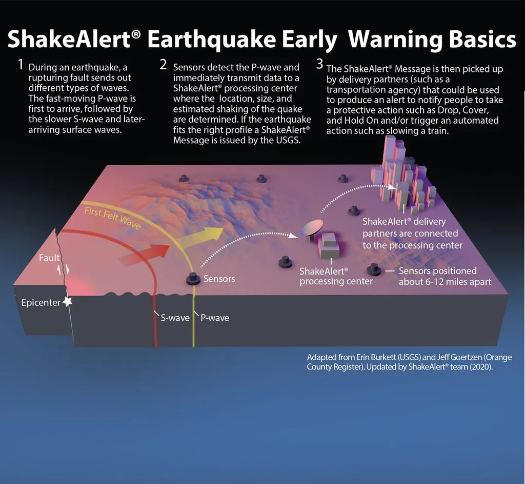
Earthquake early warning systems use fast sensors to detect the first P-waves.

The system can then:

  1. Detect the first P-wave.
  2. Begin estimating the earthquake’s location and magnitude.
  3. Send alerts to areas where stronger shaking is expected to arrive.

These systems do not predict earthquakes.

The earthquake has already started.

But communication signals travel far faster than seismic waves, so people some distance from the earthquake source may receive several seconds—and in some situations tens of seconds—of warning.

Very close to the epicentral area, however, the warning time may be extremely short or nonexistent.

Can We See P- and S-Waves?

Not directly.

A seismic wave traveling through a mass of rock cannot normally be seen with the human eye.

But its effects can be measured.

Highly sensitive instruments called seismometers record ground motion.

The resulting record is called a seismogram.

On a seismogram, the first smaller movement often marks the arrival of the P-wave, followed by stronger S-wave motion and later surface-wave energy.

These recordings allow large earthquakes to be detected even by stations thousands of kilometers away.

Why Can P-Waves Travel Through Liquids but S-Waves Cannot?

This question provides one of the easiest ways to understand the difference between the two waves.

A P-wave travels by compressing and expanding material.

Liquids can be compressed and can transmit pressure changes.

Therefore, P-waves can move through liquids.

An S-wave attempts to shear the material sideways.

Liquids cannot sustain this type of shear stress.

Therefore, the S-wave cannot propagate through them.

This single physical difference helped scientists determine that Earth’s outer core is liquid.

Frequently Asked Questions

Which seismic wave arrives first?

The P-wave.

P-waves travel faster than S-waves.

Are P-waves longitudinal or transverse?

P-waves are primarily longitudinal compressional waves. Particle motion is parallel to the direction in which the wave travels.

Are S-waves transverse?

Yes. In S-waves, particle motion is perpendicular to the direction of wave travel.

Can P-waves travel through water?

Yes.

P-waves can travel through liquids.

Can S-waves travel through water?

No.

S-waves cannot propagate through liquids.

Which seismic wave is the fastest?

The P-wave.

Which seismic wave causes more damage?

S-waves can produce stronger ground motion than P-waves, but during large earthquakes, surface waves may be responsible for some of the most damaging shaking.

Are P- and S-waves produced only by earthquakes?

No.

Explosions, volcanic activity, and some large human-made energy releases can also generate seismic waves.

Final Thoughts

At first, P- and S-waves may seem like nothing more than two different types of vibrations created by an earthquake.

In reality, they form part of the foundation of modern seismology.

P-waves are faster and can travel through solids, liquids, and gases. They move material through alternating compression and expansion in the same general direction as wave propagation.

S-waves are slower and can travel only through solids. They move material perpendicular to the direction in which the wave travels.

The difference in their speeds allows scientists to help determine earthquake locations.

The early arrival of P-waves gives earthquake early warning systems precious seconds.

And the inability of S-waves to cross the liquid outer core helped scientists understand what exists deep inside our planet.

Humans have never reached Earth’s core.

We have never brought back a rock sample from it.
Yet we know that the outer core is liquid and the inner core is solid.

One of the biggest reasons is that we can listen to the P- and S-waves sent through the planet by powerful earthquakes.

Moonstone vs Opalite: How to Tell the Difference

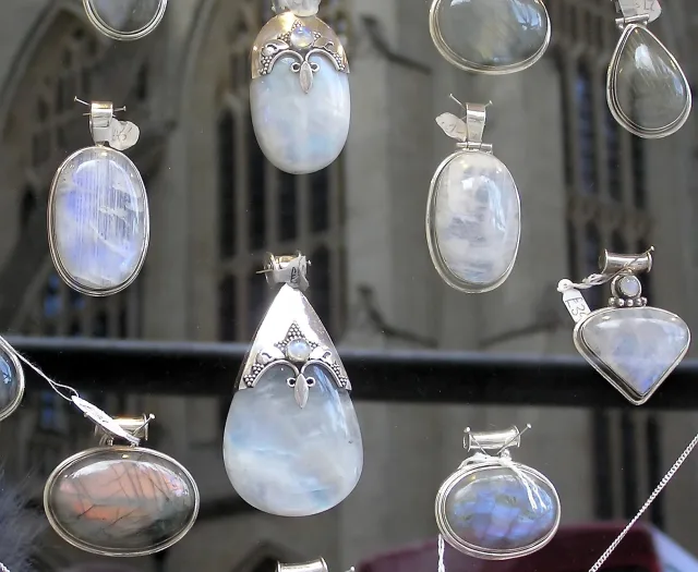
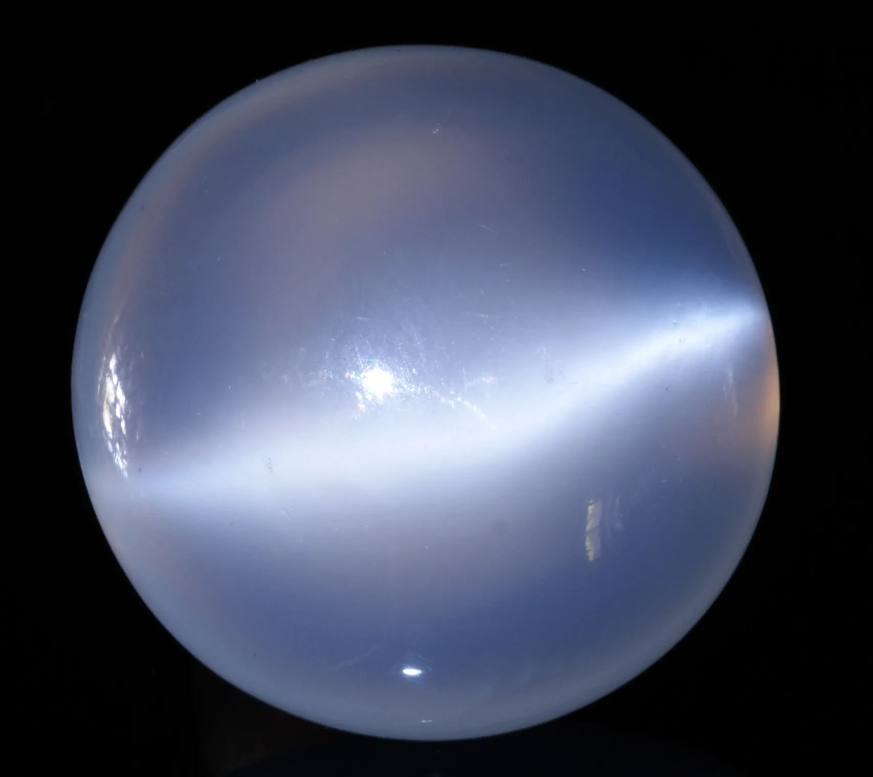
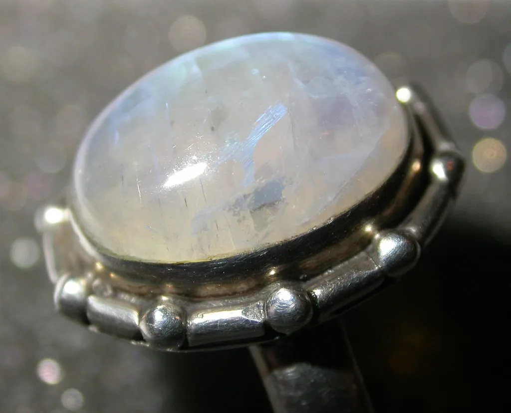
Moonstone cabochons displaying a soft blue adularescent sheen

Moonstone and opalite are easy to confuse at first glance. Both can appear milky white or translucent, both may show a blue glow under certain lighting, and both are widely sold as polished stones, beads, pendants, and cabochons.

Yet geologically, they could hardly be more different.
Moonstone is a natural gemstone belonging to the feldspar family. The material commonly sold today as opalite, on the other hand, is usually manufactured opalescent glass rather than a naturally formed mineral. The resemblance between them comes mainly from the way they interact with light—not from a shared mineral composition or geological origin.
That distinction matters because many people encounter these materials while buying jewelry or loose stones online. A pale blue stone may be advertised as moonstone, opalite, “opal moonstone,” or even simply “natural crystal,” leaving buyers wondering what they actually have.

So how can you tell moonstone from opalite? Why do both seem to glow? Why is one generally more valuable than the other? And can you identify them just by looking at a photograph?

The answers become much easier once you understand what creates their unusual optical effects.

What Is Moonstone?

SONY DSC

Moonstone is a gem-quality feldspar best known for a soft glow that appears to float beneath its surface. This effect is called adularescence, and it is the feature that gives moonstone its name and its characteristic appearance.

Traditional gemological descriptions explain moonstone as an intergrowth of alkali feldspars, particularly orthoclase and albite. As the feldspar cools, extremely fine internal structures develop. Light entering the stone interacts with these microscopic layers and is scattered, producing the floating sheen associated with moonstone. GIA describes this apparent movement of light across the gem as one of the defining characteristics of adularescence.

This is important because moonstone does not simply have a blue-colored surface.

The glow comes from inside the gemstone.

Turn a good moonstone beneath a light source and the bright area may appear to travel across the cabochon. In high-quality material, that sheen can look like a small cloud of blue or silvery light moving beneath a transparent or translucent surface.

That moving effect is one of the first clues that you may be looking at genuine moonstone rather than opalite.

Moonstone normally has a Mohs hardness of about 6 to 6.5. Its body color may be colorless, white, gray, peach, brown, greenish, or other pale shades. Particularly desirable stones can be nearly transparent with a strong blue sheen. GIA considers the strength and color of the sheen, body color, and clarity among the main factors affecting moonstone quality.

Important sources include Sri Lanka and India, with deposits also known from Madagascar, Tanzania, Myanmar, Brazil, and several locations in the United States. Sri Lanka is especially famous for moonstone-bearing gem deposits.

Why Does Moonstone Glow?

The glow is probably the main reason people become interested in moonstone in the first place.

At first it can look almost impossible: the stone itself may be nearly colorless, yet when it is moved under light, a blue or white flash suddenly appears from inside it.

The explanation is optical rather than mystical.

Moonstone contains extremely fine feldspar intergrowth structures. When incoming light reaches these microscopic boundaries, it is scattered and interferes within the material. The dimensions of these structures are small enough to interact with visible wavelengths of light.

The result is adularescence.

What makes the phenomenon particularly noticeable is that it changes as the relationship between the stone, observer, and light source changes. That is why the sheen may appear in one position and nearly disappear when the stone is rotated.

This movement is also why a single photograph can sometimes fail to show how impressive a moonstone really is.

A photograph freezes one viewing angle. Moonstone is at its best when it moves.

What Is Opalite?

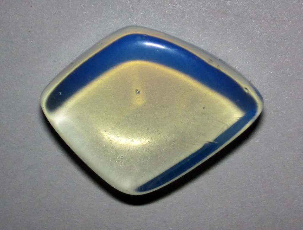
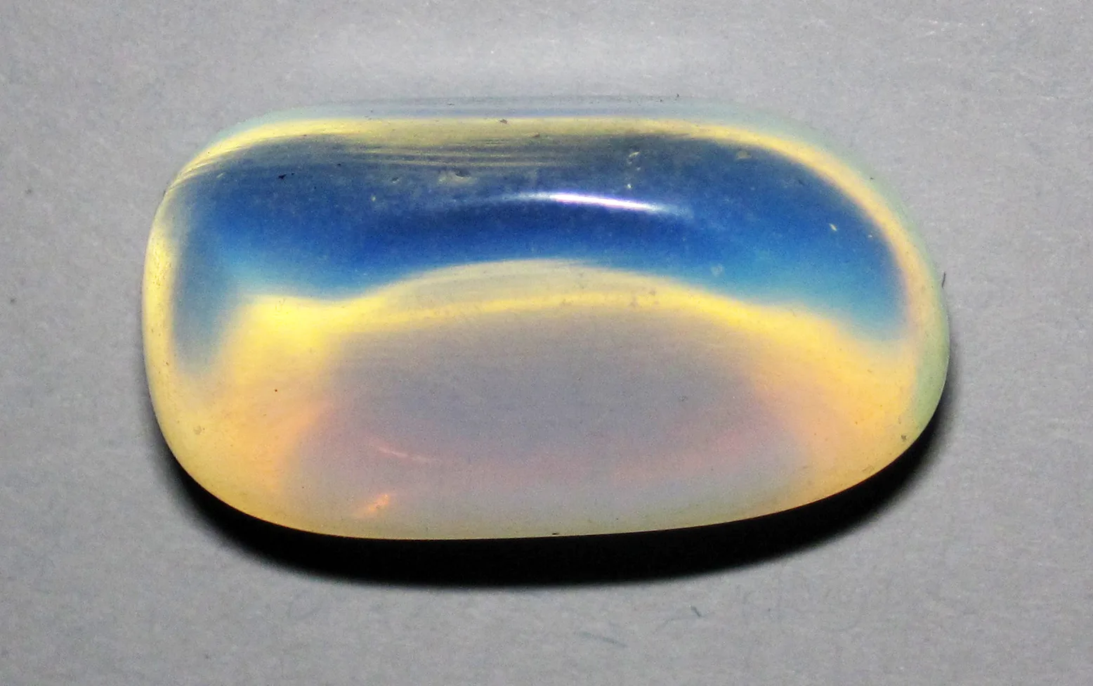
Man-made opalite glass showing its characteristic milky blue appearance

The word opalite is more complicated because it has not always been used for one single material.

Historically, the name has sometimes been applied to natural common opal. Even today, the term can occasionally appear in descriptions of natural opal-like materials.

However, when you see smooth blue-white “opalite” beads, tumbles, spheres, or pendants in the modern jewelry and crystal market, the material is usually man-made opalescent glass.

Gemological references describe commercial opalite as manufactured glass that has been designed to produce an opal-like or moonstone-like appearance. Air bubbles or swirl lines may sometimes occur inside the material as a result of manufacturing.

This distinction is worth remembering:

Moonstone forms naturally inside the Earth. Commercial opalite is generally made in a factory.

That does not make opalite worthless or unattractive.

Glass can produce beautiful optical effects, and opalite is popular precisely because it is affordable, easy to shape, and visually striking.

The problem begins only when manufactured opalite is represented as natural moonstone, natural opal, or another naturally occurring gemstone.

Why Does Opalite Look Blue and Orange?

This is one of the most interesting characteristics of opalite and probably one of the main reasons people mistake it for a natural gemstone.

Place a typical piece of opalite against a dark background and it may appear luminous blue.

Hold the same piece toward a strong light and warm yellow, peach, pink, or orange tones can become much more noticeable.

The material has been manufactured so that light is scattered as it travels through the glass. Reflected and transmitted light therefore produce noticeably different appearances.

That is why photographs of exactly the same opalite bead can look dramatically different depending on the lighting and background.

It can appear icy blue in one photograph and almost orange in another.

Moonstone behaves differently. Its most characteristic light effect is not simply a general blue coloration but a localized, moving adularescent sheen associated with its internal feldspar structure.

That difference becomes extremely useful when comparing the two.

Is Opalite a Real Gemstone?

The answer depends on what exactly is being called opalite.

In the modern commercial market, the familiar translucent blue-white opalite is usually manufactured glass. In that sense, it is not a naturally occurring mineral or natural gemstone.

But saying that “opalite can never be natural” would also be inaccurate.

The word has historically been used for natural common opal, and some sellers still use the term in other ways. Geology.com notes both meanings: natural common opal has been called opalite, while the same word is now widely used as a marketing term for manufactured glass, plastic, and other opal-like materials.

This is why context matters.

If you see a smooth, inexpensive, almost perfectly uniform blue-white stone sold in large quantities as “opalite crystal,” it is very likely the familiar manufactured material.

If someone is discussing natural opal in a mineralogical context, the terminology may mean something else.

For buyers, the safest question is therefore not simply:

“Is this opalite?”

It is:

“What material is this actually made from?”

Moonstone vs Opalite: Key Differences

FeatureMoonstoneCommercial Opalite
OriginNaturalUsually manufactured
MaterialFeldsparUsually opalescent glass
StructureCrystalline mineral materialAmorphous glass
Main optical effectAdularescenceDiffuse opalescent glow
Typical appearanceWhite, colorless, peach, gray; sometimes strong blue sheenMilky white to bluish translucent glass
Effect when movedSheen can appear to travel across the stoneGlow usually remains broader and more uniform
Mohs hardnessAbout 6–6.5Common glass opalite around 5
Internal featuresFeldspar structures and natural inclusionsMay contain bubbles or swirl lines
RarityHigh-quality material can be uncommonCan be manufactured in quantity
Typical valueHighly variable; fine specimens can be valuableUsually inexpensive

The table makes the materials look easy to separate, but real identification can be more difficult.

Low-quality moonstone may display only weak adularescence. Some glass can be very convincing. Lighting can dramatically change both materials, and polished cabochons hide many of the features visible in rough specimens.

So rather than relying on one clue, it is better to examine several.

How Can You Tell Moonstone from Opalite at Home?

The most useful first test does not require scratching, heating, or damaging the stone.

Simply move it slowly beneath a single light source.

With moonstone, look for a concentrated sheen that seems to move through or across the stone as you change its angle. The effect may suddenly become strong at one orientation and weaken at another.

With opalite, the illumination often appears more broadly distributed throughout the glass. The stone may glow blue-white in reflected light and become warmer when light passes through it, but the appearance is generally different from the floating sheen of good moonstone.

Next, examine the interior with a magnifying glass.

Perfectly round bubbles can be an important clue that you are looking at glass. Commercial opalite may contain air bubbles or flowing structures related to its manufacturing process.

Natural moonstone can certainly contain inclusions too, but those inclusions are not the same as ordinary gas bubbles trapped in manufactured glass. GIA notes characteristic moonstone inclusions that can include small tension cracks sometimes described as “centipede” inclusions.

Uniformity is another clue.

If dozens of inexpensive beads all have nearly identical transparency, color, and internal appearance, that consistency may point toward manufactured material. Natural gemstones normally show considerably more variation.

None of these visual tests alone provides absolute proof.

For an inexpensive bead, visual examination may be sufficient for practical purposes. For a valuable gemstone, professional gemological testing is the appropriate way to obtain a reliable identification.

Can You Identify Moonstone and Opalite From a Photo?

Sometimes.

But not always.

A good photograph can reveal several useful clues. Very uniform milky glass, obvious bubbles, strongly colored edges, or the typical blue-white and orange appearance of opalite may make identification relatively straightforward.

Likewise, a sharply localized blue sheen floating across an otherwise transparent feldspar can strongly suggest moonstone.

The problem is that gemstone photographs are highly dependent on illumination.

A seller can use a dark background to intensify the blue appearance of opalite. Backlighting can produce warm orange tones. Moonstone can appear almost completely ordinary if photographed from the wrong angle, while carefully positioned lighting can make its adularescence look dramatically stronger.

Exposure, white balance, saturation, HDR processing, and image editing make the situation even harder.

So a photograph can provide clues, but it should not be treated as laboratory evidence.

This becomes especially important when purchasing expensive moonstone online.

A single spectacular photograph tells you what the gem looked like at one carefully selected angle.

A short video showing the stone turning under neutral lighting is usually far more informative.

Why Does Opalite Look So Much Like Moonstone?

The similarity is largely a result of what humans find visually attractive.

Moonstone became famous for its soft, floating, moonlike glow. Manufactured opalescent glass can reproduce some of the same general visual qualities: translucency, milky body color, blue light scattering, and an internal-looking glow.

From several feet away—or in a small online photograph—the two can therefore look surprisingly similar.

But the physics behind the appearance is not the same.

In moonstone, the optical effect is tied to microscopic feldspar intergrowth textures produced during the mineral’s geological history.

In opalite glass, the appearance is created during manufacture.

One is the result of mineral formation and cooling within geological environments.

The other is engineered optical glass.

That is why understanding how the light is produced is much more useful than simply comparing their colors.

Why Is Moonstone Usually More Valuable Than Opalite?

Moonstone has something manufactured opalite cannot reproduce: natural geological rarity.

Natural moonstone cabochon set in a ring

Feldspar itself is extremely common. In fact, feldspar minerals make up a very large portion of Earth’s crust. But not every feldspar crystal develops attractive adularescence, suitable clarity, useful size, and enough structural quality to become a fine gemstone.

The best moonstones combine several desirable characteristics.

A nearly colorless or transparent body can allow the optical effect to stand out clearly. Strong blue sheen is particularly prized. The sheen should ideally be visible over a large portion of the stone and move attractively as the gem is rotated.

Clarity also matters, although complete absence of inclusions is not expected in every natural gem.

Cutting is equally important.

Moonstone is commonly shaped into a cabochon because the curved surface can display adularescence particularly effectively. An incorrectly oriented stone may contain excellent material but show only a weak flash.

This is why two moonstones of similar size can have very different values.

Opalite has a different economic structure.

Because commercial opalite glass can be manufactured in large quantities, its supply is not limited by the discovery of rare gem-quality geological material. A producer can make more glass.

That does not mean all opalite jewelry must be cheap—the craftsmanship, metal, designer, and setting can have value—but the raw material itself normally does not have the same rarity component as fine natural moonstone.

Does a Blue Flash Automatically Mean the Moonstone Is Valuable?

No.

This is another common misunderstanding.

A blue sheen is desirable, but value cannot be determined by seeing one blue flash in one photograph.

Gemologists consider the overall quality of the phenomenon as well as body color, clarity, cut, and size. According to GIA, the finest moonstone combines a relatively clean, nearly transparent appearance with a strong mobile blue shimmer.

Coverage matters too.

A small patch of blue visible only at one difficult angle is not equivalent to a vivid sheen that travels broadly across the face of the stone.

The same principle explains why videos are useful when evaluating moonstone online: adularescence is a dynamic effect.

Is Opalite Fake Moonstone?

Not automatically.

A material is not fraudulent simply because it is manufactured.

If a seller offers a necklace clearly labeled opalite glass, the buyer knows what the product is. There is nothing inherently deceptive about using attractive manufactured glass in jewelry.

Calling the same product natural moonstone, however, is a different matter.

That description would imply a geological origin and mineral identity the glass does not possess.

This distinction also applies to price.

A person may happily choose opalite because they like its appearance and do not care whether it came from a mine or a furnace.

Another buyer may specifically want a natural gemstone.

Both choices are reasonable.

What matters is accurate disclosure.

Moonstone vs Opal vs Opalite

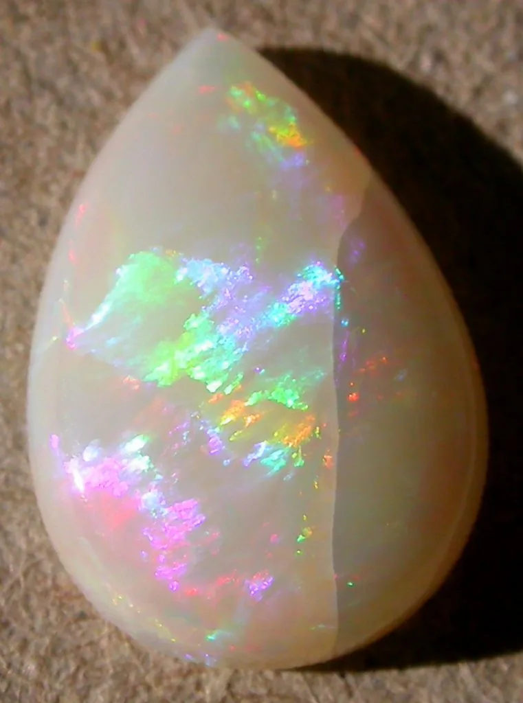
Natural white opal cabochon shown for comparison with moonstone and opalite

The similar names create unnecessary confusion because these are three very different materials.

Moonstone belongs to the feldspar family and is famous for adularescence.

Natural opal is fundamentally a hydrated silica material. Precious opal may display spectral play-of-color, while common opal does not necessarily show that phenomenon.

Commercial opalite is usually manufactured opalescent glass or another imitation material.

So opalite should not be thought of as simply “another type of moonstone.”

Nor should modern commercial opalite automatically be assumed to be natural opal.

The similarity is primarily visual and commercial, not mineralogical.

Which One Should You Choose?

If the goal is to own a natural geological material, moonstone is the obvious choice between the two.

It offers something especially interesting for anyone interested in geology or mineralogy: its beauty is directly linked to microscopic structures produced during feldspar formation and cooling.

If the goal is simply an attractive blue-white material for inexpensive jewelry, opalite has its own appeal. Its low price makes it widely accessible, and its changing appearance under different lighting can be striking.

Neither material needs to pretend to be the other.

In fact, understanding what they really are makes both more interesting.

Moonstone shows what geological processes can do with feldspar and light.

Opalite shows what humans can reproduce with glass and optical engineering.

Final Identification Checklist

If you are holding an unknown polished stone and trying to decide whether it is moonstone or opalite, check several characteristics together:

  • Rotate it beneath a single light source and look for a localized sheen that appears to move across the stone.
  • Compare its appearance in reflected light and transmitted light.
  • Examine the interior with magnification for perfectly round gas bubbles or glass-like swirl structures.
  • Look at whether the material is unusually uniform compared with typical natural gemstones.
  • Check whether dozens of identical pieces are being sold at extremely low prices.
  • Ask the seller whether the material is natural feldspar or manufactured glass.
  • Do not rely only on the word “crystal,” “opal,” “moonstone,” or “opalite” in a product title.
  • For an expensive specimen, use a qualified gemologist or gem-testing laboratory rather than destructive home tests.

Final Thoughts

Moonstone and opalite demonstrate why identifying gemstones by color alone can be misleading.

Both can appear pale, translucent, and almost luminous. Under the right lighting, both may display an attractive blue glow. Yet beneath that superficial similarity are two completely different stories.

Moonstone is a natural feldspar gemstone whose characteristic adularescence is produced by microscopic internal structures that interact with light. Commercial opalite is usually manufactured opalescent glass whose appearance is deliberately engineered to scatter light.

The easiest visual distinction is therefore not simply what color the stone is, but how the light behaves when the stone moves.

A genuine moonstone can produce a concentrated sheen that seems to travel beneath its surface. Opalite generally produces a broader, more uniform glow and can show strong blue-to-warm color changes depending on the background and direction of illumination.

For someone holding an unknown stone, that difference is often the best place to start.

And for anyone buying one, perhaps the most important question is even simpler:

Was this material formed by geology—or manufactured to look as though it was?

Rock Identification Guide: How to Identify Rocks Like a Geologist

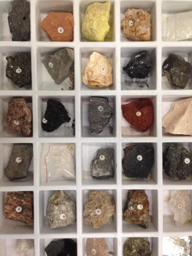
Rock Collection

You are walking along a beach, through the mountains, in your backyard, or beside a road when you notice an unusual rock. Maybe it has a strange color, sparkling crystals, or unusual lines across its surface. The first question is usually the same: What kind of rock is this?

Identifying a rock may seem difficult at first. The same type of rock can occur in different colors, while completely different rocks may sometimes look surprisingly similar. This is why geologists do not identify rocks by color alone. They look at texture, grain size, mineral composition, hardness, layering, fracture, magnetic properties, and sometimes simple chemical reactions.

The good news is that you do not need a laboratory to make a basic rock identification. A hand lens, magnet, steel nail, ceramic tile, and sometimes even a little vinegar can help you distinguish many common rocks.

In this guide, we will go step by step through how to examine a rock, how to distinguish igneous, sedimentary, and metamorphic rocks, and how to recognize common rocks such as granite, basalt, sandstone, limestone, obsidian, schist, and gneiss.

Quick Rock Identification Chart

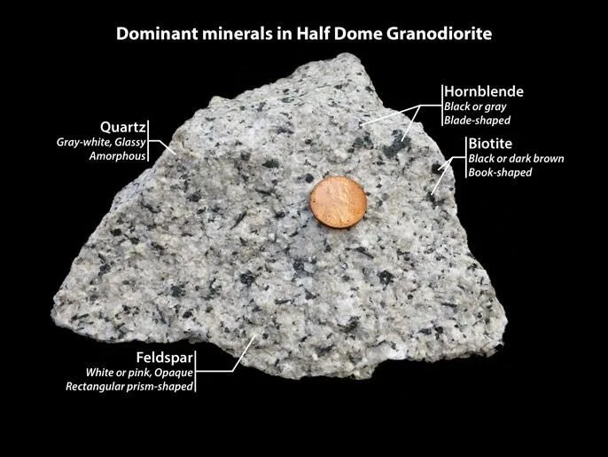
Granite rock from Yosemite

The following chart is a good starting point when you are trying to identify a rock.

RockTypeCommon ColorTextureGrain SizeKey Identification Feature
GraniteIgneousGray, pink, whiteCrystallineCoarseVisible quartz and feldspar crystals
BasaltIgneousBlack, dark grayFine-grainedVery fineDark and dense
ObsidianIgneousUsually blackGlassyNo visible crystalsLooks like volcanic glass
PumiceIgneousWhite, light grayVesicularFineExtremely light and full of holes
SandstoneSedimentaryBrown, red, tanGrittySand-sizedFeels like sandpaper
LimestoneSedimentaryWhite, cream, grayVariableUsually fineReacts with acid
ShaleSedimentaryGray, black, brownLayeredVery fineSplits into thin layers
ConglomerateSedimentaryVariableClasticCoarseContains rounded pebbles
MarbleMetamorphicWhite or coloredCrystallineMedium to coarseRecrystallized calcite
SlateMetamorphicGray, blackFoliatedVery fineSplits into flat sheets
SchistMetamorphicGray, silveryFoliatedMedium to coarseShiny mica minerals
GneissMetamorphicBlack and whiteBandedCoarseDistinct light and dark mineral bands
QuartziteMetamorphicWhite, gray, pinkMassiveMediumVery hard and quartz-rich

This chart cannot provide a definite identification on its own, but it is a strong starting point for narrowing down the possibilities.

First: Is It a Rock or a Mineral?

Basalt rock photograph

One of the most common mistakes in rock identification is treating rocks and minerals as the same thing.

A mineral is a naturally occurring solid material with a specific chemical composition and crystal structure.

Quartz, calcite, feldspar, pyrite, and mica are minerals.

A rock, on the other hand, is made from one or more minerals.

Granite, for example, commonly contains quartz, feldspar, and mica. When you look closely at granite, you usually see several different colored crystals rather than one uniform material.

Some rocks can be made almost entirely from one mineral. Quartzite is mostly quartz, while marble is mainly composed of calcite.

If your specimen appears to be one single crystal or one uniform crystalline material, it may be worth considering whether it is a mineral rather than a rock.

How to Identify a Rock

The best way to identify a rock is to examine several characteristics together instead of relying on only one.

A systematic examination will usually give you the best result.

1. Look at the Color

Color is usually the first feature people notice, and it can provide a quick clue.

For example:

  • Granite is commonly white, gray, or pink.
  • Basalt is usually dark gray or black.
  • Sandstone may be red, brown, tan, or light-colored.
  • Limestone is often white, cream, or gray.
  • Obsidian is commonly black.

However, color alone cannot reliably identify a rock.

The same type of rock can have different colors depending on its mineral content, oxidation, weathering, and environmental conditions.

Granite, for example, may be pink or almost white. Sandstone may become strongly red when iron oxides are present.

Use color as your first clue, but always combine it with other features.

2. Examine the Rock Texture

Texture is one of the most useful clues because it can tell you a great deal about how a rock formed.

Clean the specimen if possible and examine it in good natural light. A small hand lens can be very useful.

Can You See Individual Crystals?

If you can clearly see large crystals that appear to interlock with one another, the rock may have formed from magma that cooled slowly underground.

Granite, diorite, and gabbro are classic examples.

Is the Rock Very Fine-Grained?

If the individual crystals are difficult or impossible to see with the naked eye, lava may have cooled quickly at or near Earth’s surface.

Basalt, andesite, and rhyolite are commonly fine-grained volcanic rocks.

Does It Look Like Glass?

If the rock is shiny, glass-like, and breaks into very sharp edges, it may be obsidian.

Is It Full of Holes?

If the rock contains many small or large holes, gas bubbles may have been trapped in lava as it cooled.

Pumice and scoria are typical examples.

Can You See Sand Grains?

If the surface feels gritty or similar to sandpaper, sandstone is a strong possibility.

Does It Have Light and Dark Bands?

Distinct alternating bands of light and dark minerals are one of the strongest clues for identifying gneiss.

Does the Surface Sparkle?

If the rock contains many shiny, flaky minerals, especially mica, it may be schist.

3. Check the Grain Size

Grain size is particularly useful when identifying igneous and sedimentary rocks.

Coarse-Grained Rocks

If individual crystals are easily visible to the naked eye, the rock is considered coarse-grained.

Examples include:

  • Granite
  • Gabbro
  • Diorite
  • Pegmatite

Fine-Grained Rocks

If crystals are difficult or impossible to see without magnification, the rock may have cooled much more quickly.

Examples include:

  • Basalt
  • Andesite
  • Rhyolite

Very Fine-Grained Rocks

Rocks such as shale and slate have extremely small grains.

4. Test the Hardness

Mohs Hardness Scale

Different rocks and minerals have different hardness levels.

  • Fingernail: about Mohs 2.5
  • Copper coin: about Mohs 3
  • Steel nail or knife: around Mohs 5–5.5
  • Glass: around Mohs 5.5

If your specimen can easily scratch glass, it may contain a large amount of quartz.

5. Try the Streak Test

For a streak test, use an unglazed white porcelain tile.

Rub the specimen across the tile and observe the color of the powder it leaves behind.

This test is especially useful for minerals such as hematite, magnetite, and pyrite.

6. Test It With a Magnet

A small strong magnet can help detect magnetite and other iron-rich minerals.

However:

A magnetic rock is not automatically a meteorite.

Many Earth rocks and industrial materials are magnetic.

7. Try the Acid Test

Calcite-rich rocks react with acid.

Limestone commonly produces visible fizzing when dilute hydrochloric acid is applied.

Marble can also react because it contains recrystallized calcite.

Vinegar can sometimes be used as a weaker home test.

8. Look for Layers, Foliation, and Bands

Gneiss boulder along Ryan Mountain Trail

Directional structures can tell you a lot about a rock’s history.

Sedimentary Layers

Stacked layers may indicate sandstone, shale, limestone, or another sedimentary rock.

Does It Split Into Thin Sheets?

Shale and slate may both split into thin pieces, but slate usually has a more regular metamorphic cleavage.

Light and Dark Bands

Alternating light and dark mineral bands are characteristic of gneiss.

Shiny, Aligned Minerals

Aligned shiny minerals are common in schist.

How to Identify the Three Main Rock Types

Vesicular Basalt – Top View

Most rocks belong to three major groups:

  • Igneous rocks
  • Sedimentary rocks
  • Metamorphic rocks

How to Identify Igneous Rocks

Igneous rocks form when magma or lava cools and solidifies.

Common features include:

  • Interlocking crystals
  • Glassy textures
  • Vesicles
  • Mineral crystals
  • Usually no fossils

Examples include granite, basalt, obsidian, pumice, gabbro, diorite, and rhyolite.

How to Identify Sedimentary Rocks

Sandstone Sample

Sedimentary rocks commonly form from accumulated sand, mud, gravel, shells, or chemical precipitates.

Common features include:

  • Layers
  • Sand or gravel grains
  • Fossils
  • Rounded or angular rock fragments

Examples include sandstone, limestone, shale, conglomerate, and breccia.

How to Identify Metamorphic Rocks

Metamorphism of Shale and Sandstone in the Black Hills

Metamorphic rocks form when existing rocks are changed by heat and pressure without completely melting.

Common features include:

  • Mineral banding
  • Foliation
  • Aligned minerals
  • Recrystallized textures

A common metamorphic sequence is:

Shale → Slate → Phyllite → Schist → Gneiss

Common Rocks and How to Identify Them

Granite

Granite is usually coarse-grained and contains visible quartz and feldspar crystals.

Basalt

Basalt is usually dark, dense, and fine-grained.

Sandstone

Sandstone commonly has a gritty texture and visible sand-sized grains.

Limestone

Limestone commonly contains calcite and often reacts with acid.

Shale

Shale is extremely fine-grained and commonly splits along thin layers.

Obsidian

Obsidian has a glassy surface and conchoidal fracture.

Pumice

Pumice contains many gas bubbles and is extremely lightweight.

Slate

Slate is fine-grained and commonly splits into flat sheets.

Schist

Schist contains abundant visible, shiny mica minerals.

Gneiss

Gneiss is characterized by distinct light and dark mineral bands.

Marble

Marble is crystalline, commonly calcite-rich, and reacts with acid.

Quartzite

Quartzite is extremely hard and commonly scratches glass.

Rock Identification by Color

Color can narrow down the possibilities, but should never be used alone.

Black Rocks

  • Basalt
  • Obsidian
  • Anthracite
  • Magnetite-rich rocks

White Rocks

  • Marble
  • Quartzite
  • Chalk
  • Light-colored granite

Red Rocks

  • Red sandstone
  • Jasper
  • Iron-rich rocks

Green Rocks

  • Serpentinite
  • Greenstone
  • Chlorite-rich metamorphic rocks

Pink Rocks

  • Granite
  • Rhyolite
  • Some quartzites

Rock Identification by Texture

TexturePossible Rocks
GlassyObsidian
Full of holesPumice, Scoria
Large crystalsGranite, Diorite, Gabbro
Sandy or grittySandstone
Thin layersShale, Slate
Strong bandsGneiss
Shiny and flakySchist
Rounded pebblesConglomerate
Angular fragmentsBreccia

What Kind of Rock Did I Find?

Can You See Crystals?

Yes: Granite, gabbro, or diorite may be possible.

Does the Rock Have Layers?

Yes: Look at sandstone, shale, limestone, and other sedimentary rocks.

Does It Have Light-Dark Bands or Shiny Aligned Minerals?

Yes: Consider gneiss or schist.

Does It Look Glassy?

Yes: Obsidian is a strong possibility.

Is It Full of Holes?

Yes: It may be pumice, scoria, or vesicular basalt.

Does It Feel Sandy?

Yes: Sandstone may be likely.

Does It Fizz With Acid?

Yes: It may be limestone, marble, or another calcite-rich rock.

Can You Identify a Rock From a Photo?

Sometimes you can narrow down the possibilities, but a photograph alone usually cannot provide a certain identification.

A photo can show:

  • Color
  • Texture
  • Grain size
  • Layering
  • Banding
  • Crystals
  • Vesicles

But it cannot directly show:

  • Hardness
  • Density
  • Magnetism
  • Acid reaction
  • Streak

Simple Rock Identification Tools You Can Keep at Home

A basic rock identification kit can include:

  • 10× hand lens
  • Small strong magnet
  • Steel nail
  • Copper coin
  • Unglazed ceramic tile
  • Small ruler
  • Flashlight
  • Notebook
  • Water
  • Vinegar

Frequently Asked Questions

How Do I Identify a Rock I Found?

Start with color, texture, and grain size. Then check hardness, layering, magnetism, and acid reaction.

How Can I Tell if a Rock Is Igneous?

Look for interlocking crystals, glassy textures, or gas bubbles.

How Can I Tell if a Rock Is Sedimentary?

Look for layers, visible grains, fragments, or fossils.

How Can I Tell if a Rock Is Metamorphic?

Look for foliation, mineral alignment, recrystallization, or banding.

How Can I Tell if a Rock Contains Quartz?

Quartz is hard, often glassy or translucent, and can scratch glass.

Are Rock Identification Apps Accurate?

They can help narrow down possibilities, but photo-based identification should not be considered definitive.

Could the Rock I Found Be Valuable?

Possibly, but value depends on mineral content, rarity, quality, size, and collector demand.

Could a Black Magnetic Rock Be a Meteorite?

Possibly, but most black magnetic rocks are not meteorites.

Conclusion

Identifying rocks is often a little like detective work.

Color gives you the first clue, but texture, grain size, mineral composition, hardness, layering, magnetism, and other features provide the evidence needed to narrow down an identification.

Large crystals can indicate slow cooling underground. Fine crystals can indicate rapid cooling. Sedimentary layers record deposition, while mineral bands may preserve the effects of intense heat and pressure.

Rock identification is therefore more than simply giving a specimen a name. It is also a way of reading the geological history recorded inside it.

Yellowstone’s Supereruption Was Not a Single Explosion, New Evidence Suggests

James St. John de Newark, Ohio

1. Yellowstone’s Last Supereruption Wasn’t as Simple as We Thought

Aerial view of the Yellowstone Caldera rim and rhyolite lava flows

For years, textbooks and popular science accounts have painted Yellowstone’s last supereruption as one single, massive event that unfolded in a matter of hours. The story went something like this: a giant magma chamber emptied out, colossal pyroclastic flows swept across the landscape, and what remained collapsed into the Yellowstone Caldera we know today.

But detailed fieldwork by geologists with the Yellowstone Volcano Observatory (YVO) in the Sour Creek Dome area suggests that picture is far more complicated than we realized.

New findings indicate that the Lava Creek Tuff supereruption, which occurred roughly 631,000 years ago, wasn’t a single moment of catastrophe at all. Instead, it appears to have unfolded as a series of eruptive pulses, separated by real stretches of time.

And the research doesn’t just change how we think the eruption happened — it’s also raising new questions about how the caldera’s northeastern boundary should be interpreted, and even how Sour Creek Dome itself came to be.

Apparently, Yellowstone’s geological past is still an unfinished story.

2. What Was the Lava Creek Tuff Eruption?

Comparison of Yellowstone Lava Creek Tuff eruption volume with other major volcanic eruptions

Lava Creek Tuff is the name given to the volcanic rocks produced by the enormous eruption that struck Yellowstone about 631,000 years ago.

The eruption is estimated to have ejected roughly 1,000 cubic kilometers of volcanic material — compare that to the roughly 1 cubic kilometer expelled during the 1980 eruption of Mount St. Helens, and the scale starts to sink in.

Put another way, Lava Creek Tuff was, by volume, on the order of a thousand times bigger than Mount St. Helens’ 1980 eruption.

It’s also the event credited with forming the Yellowstone Caldera that today makes up much of Yellowstone National Park.

In traditional geological mapping, Lava Creek Tuff has generally been split into two major ignimbrite units, known simply as “Member A” and “Member B.”

Yellowstone’s roughly 2.1-million-year geological history includes three known caldera-forming supereruptions:

  • Huckleberry Ridge Tuff — about 2.1 million years ago
  • Mesa Falls Tuff — about 1.3 million years ago
  • Lava Creek Tuff — about 631,000 years ago

The youngest of the three, Lava Creek, is also one of the most significant events in shaping the volcanic system we see today.

3. What Geologists Found at Sour Creek Dome

Map showing the relationship between Lava Creek Tuff and Sour Creek Dome at Yellowstone Caldera

At the heart of this research is Sour Creek Dome, located in the northeastern part of the Yellowstone Caldera.

Some of the rock in this area was long believed to belong to Huckleberry Ridge Tuff — one of Yellowstone’s older, larger eruptions.

New dating work says otherwise.

Argon-isotope age analyses show that some of these rocks are actually around 631,000 years old — placing them squarely within the Lava Creek Tuff eruption, not the older Huckleberry Ridge event.

Over the past several years, geologists have painstakingly remapped the area and found that what was once treated as a single rock unit is actually made up of five distinct ignimbrite packages.

The average age of these units works out to roughly 631,500 years.

Field relationships also suggest that these ignimbrites may have erupted from more than one local vent within what is now mapped as the caldera boundary — hinting that Lava Creek Tuff wasn’t a simple, single-source event.

4. Evidence for Multiple Eruptive Pulses

Quartz and sanidine crystals in Lava Creek Tuff samples from Yellowstone Caldera. Samples of Lava Creek Tuff, which erupted during the formation of Yellowstone Caldera about 631,000 years ago, with large quartz and sanidine crystals circled in red. Photos by Faith Nolander, July 22, 2025.

Some of the most compelling evidence sits inside the newly identified ignimbrites themselves.

Certain units contain fragments of older ignimbrite — material that had already cooled, solidified, and broken apart — embedded within younger pyroclastic flows.

That detail matters.

For older material to cool completely, harden, fracture, and then get ripped up and swept into a later flow, a meaningful amount of time has to pass in between.

This is a strong signal that the eruption wasn’t a single continuous blast lasting seconds or minutes, but something that played out across multiple distinct phases.

Current dating techniques aren’t yet precise enough to pin down exactly how long the gaps between phases lasted — they could have been days, weeks, months, or in some cases longer.

So instead of thinking of Lava Creek Tuff as one “moment” of eruption, it may be more accurate to picture it as a drawn-out, multi-stage volcanic process.

5. Yellowstone May Have Had Several Magma Bodies

Geologic record showing the episodic eruption sequence of Yellowstone’s Huckleberry Ridge Tuff

The chemistry of crystals pulled from Sour Creek Dome’s ignimbrites offers another important clue.

Crystals from different ignimbrite packages don’t all share the same chemical fingerprint.

That variation suggests the eruption wasn’t drawn from one single, perfectly homogeneous magma body.

Instead, several chemically distinct pockets of magma may have existed beneath Yellowstone at the time.

Researchers now think at least four separate magma bodies may have contributed to the Sour Creek Dome eruption sequence — a striking idea for modern volcanology.

Older models tended to picture large caldera systems as one enormous, liquid-filled magma chamber sitting underground.

More recent research increasingly suggests that big volcanic systems are made up of interconnected but chemically and physically distinct magma regions.

The new Yellowstone findings fit neatly into that more complex picture.

6. How Long Could the Supereruption Have Lasted?

There’s no firm answer to this yet.

The new research shows time passed between different phases of the Lava Creek Tuff eruption, but pinning down exactly how much time is proving difficult.

A similar pattern shows up in Yellowstone’s older Huckleberry Ridge Tuff eruption.

Earlier studies found that this massive event also wasn’t one uninterrupted blast — its different eruptive phases appear to have been separated by real gaps in time.

The new field evidence from Lava Creek Tuff points toward a similar scenario.

The fact that some erupted material had time to cool, solidify, and then get mixed into later pyroclastic flows tells us that at least some of the phases were separated by a meaningful stretch of time.

Which means the old, simple story — “Yellowstone erupted all at once” — probably doesn’t hold up anymore.

A more accurate description is that this caldera-forming supereruption was a complex process that unfolded across multiple stages.

7. What Is an Ignimbrite?

Close-up view of welded ignimbrite from Yellowstone’s Huckleberry Ridge Tuff

An ignimbrite is the volcanic rock left behind by a pyroclastic density current — the fast-moving, superheated mix of ash, pumice, crystals, rock fragments, and gas that pyroclastic eruptions produce.

During large eruptions, these currents can race across the landscape at extremely high speed, hugging the ground and covering huge areas.

As the material settles and compacts, it eventually hardens into the rock we call ignimbrite.

Some ignimbrites deposit while still so hot that the ash and pumice fragments actually weld together.

By studying an ignimbrite’s thickness, mineral content, crystal chemistry, and how it relates to surrounding rock layers, geologists can reconstruct past eruptions in remarkable detail.

That’s exactly why distinguishing five separate ignimbrite packages at Sour Creek Dome is such a big deal.

Each new layer represents another chapter in the story of what happened 631,000 years ago.

8. Is Sour Creek Dome Really a “Resurgent Dome”?

One of the more intriguing results of the new research concerns the origin of Sour Creek Dome itself.

For a long time, Sour Creek Dome has been interpreted as one of two large “resurgent domes” within the Yellowstone Caldera.

A resurgent dome forms when, after a large caldera collapses, pressure from underlying magma and hydrothermal systems pushes the caldera floor back upward, creating a broad, dome-shaped bulge.

But the new mapping work suggests at least part of Sour Creek Dome may have formed differently.

Researchers now think much of the area’s topographic high may simply be a structural feature — the product of thick ignimbrite packages stacking up on top of one another over successive eruptions.

There’s also evidence that some faulting in the region occurred hundreds of thousands of years after the Lava Creek Tuff eruption itself.

That finding could prompt a broader rethink of Yellowstone’s post-caldera deformation history.

9. Has the Yellowstone Caldera Boundary Been Mismapped?

Confirming that the new rocks at Sour Creek Dome belong to Lava Creek Tuff raised another interesting problem.

The northeastern boundary of the Yellowstone Caldera has been mapped according to a particular geological model for decades.

But the location of these newly identified ignimbrite units suggests parts of that boundary may need to be reconsidered.

Researchers now propose that the caldera’s northeastern edge may have a somewhat different geometry than previously thought.

If that reinterpretation holds up, the Yellowstone Caldera could turn out to be slightly smaller and more rounded than some existing maps show.

That doesn’t mean the caldera has been wildly mismapped overall.

But it’s a reminder that modern dating techniques and detailed fieldwork can still redraw boundaries that have stood, largely unquestioned, for decades.

That’s really one of the most fascinating things about geology: even places we think we know exceptionally well can still surprise us once someone goes back and looks closely.

10. Why This Changes the Traditional Yellowstone Model

Seismic reflection data showing the top of the magma reservoir beneath Yellowstone Caldera along a cross section that runs from Canyon Village in the northwest (X) to near Lake Butte in the southeast (X`).  The top panel shows seismic P-wave (compressional wave) reflectivity, with evidence for the sharp reservoir top labeled. The middle panel shows seismic reflections where P-waves convert to S-waves (shear waves) as they reflect off the top of the reservoir. Combined information from the two reflection types helps constrain the total fluid fraction and relative amounts of bubbles and magma at the very top of the reservoir. The bottom panel shows a schematic cartoon interpretation in which a large reservoir that is several kilometers thick mostly contains a small amount of magma in the pore space between crystals, and a thin layer at the very top transiently accumulates bubbles that rise through the magma and temporarily reside in pore space between crystals and some melt.

Supereruptions have long been described as the product of a huge magma chamber reaching a breaking point and suddenly emptying out.

That model isn’t entirely wrong — but the real geological process was very likely far more complicated.

Work on both Huckleberry Ridge Tuff and now Lava Creek Tuff suggests that caldera-forming eruptions can involve several distinct magma bodies and multiple eruptive centers, unfolding across multiple stages rather than a single blast.

Under this framework, a “supereruption” may be less a single event than a geologically connected sequence of eruptions.

That distinction matters well beyond understanding Yellowstone’s past.

It could also reshape how scientists interpret other large caldera systems around the world.

11. Does This Mean Yellowstone Is More Dangerous Today?

No.

This new research is about events that happened 631,000 years ago — it doesn’t point to any new signal that a major eruption is coming anytime soon.

The fact that the ancient eruption turned out to be more complex than previously thought doesn’t mean Yellowstone is any closer to erupting today.

Scientists’ goal here is to reconstruct past volcanic processes as accurately as possible, in order to better understand how large caldera systems evolve over time.

That knowledge can eventually help improve future hazard assessments, but the study itself is not a warning of an imminent eruption.

It’s worth separating this kind of careful scientific research from the “supervolcano is waking up” headlines that circulate online — the two are not the same thing.

12. What Yellowstone Is Doing Right Now

Aerial view of active geysers and hydrothermal features in Yellowstone's Upper Geyser Basin
Aerial view of active geysers and hydrothermal features in Yellowstone’s Upper Geyser Basin

Yellowstone remains an active volcanic and hydrothermal system.

The area experiences numerous small earthquakes every year. Its geysers, hot springs, and fumaroles remain active. And the ground surface undergoes slow cycles of uplift and subsidence that can be measured with GPS instruments.

Most of this activity is entirely typical of Yellowstone’s normal behavior.

As of August 2026, the Yellowstone Volcano Observatory lists Yellowstone’s volcano alert level as NORMAL and its aviation color code as GREEN.

There is no unusual activity in the region pointing toward an imminent eruption.

Yellowstone is continuously monitored using seismometers, GPS stations, satellite measurements, hydrothermal observations, and various geochemical methods.

That web of monitoring means scientists have multiple independent ways of catching any significant change in the system, should one occur.

13. What This Discovery Tells Us About Supervolcanoes

Schematic diagram of the crystal-rich magma system beneath Yellowstone Caldera

Perhaps the most important takeaway from this new Yellowstone research is that large volcanic systems are more complicated than we tend to assume.

“A giant magma chamber fills up and then suddenly erupts” is an easy story to tell — but real systems in nature are rarely that simple.

Large silicic magma systems can be made up of magma bodies at different depths, with different chemical compositions, interacting with one another over time.

Some of these bodies may take part in an eruption while others stay largely untouched.

Different regions of the system can activate at different times, turning what looks like a single big event into a sequence of eruptive phases.

The Lava Creek Tuff record at Yellowstone may be exactly this kind of system, preserved in the rock.

That’s likely to shift how future research approaches other large calderas too — paying closer attention to multi-stage volcanic processes rather than assuming a single, all-at-once explosion.

14. Final Thoughts

Geologists recording field data at a rock outcrop in Yellowstone National Park

Yellowstone’s last supereruption, roughly 631,000 years ago, may have been a far more complicated event than we’ve long assumed.

New mapping and dating work at Sour Creek Dome has uncovered five previously unrecognized ignimbrite packages. The structure of these rocks, and the chemistry of the crystals within them, suggests multiple eruptive phases and several distinct magma bodies may have contributed to the sequence.

The findings are also raising new questions about how Sour Creek Dome formed and about the true position of the Yellowstone Caldera’s northeastern boundary — ideas that have gone largely unchallenged for decades.

It’s worth repeating: none of this means Yellowstone is about to erupt anytime soon.

What it really shows is something else entirely.

Even in one of the most heavily studied volcanic regions on Earth, geologists are still working out the details of events that happened hundreds of thousands of years ago.

Every new rock exposure, every crystal analysis, and every fresh age measurement brings the past a little more clearly into focus.

Yellowstone’s story may not be about one giant explosion after all.

Perhaps what the rocks are really telling us is a longer, messier story — one written across a whole series of eruptions, rather than a single moment in time.


Sources: U.S. Geological Survey (USGS) Yellowstone Volcano Observatory and Caldera Chronicles publications; recent field, geochronology, and volcanology research on Sour Creek Dome and the Lava Creek Tuff.

10 Places That Look Like Other Planets

Earth is generally referred to as the Blue Planet, but within its familiar landscapes there are places so alien that they can easily be confused with distant worlds. These locations share geological, chemical or atmospheric characteristics with other planets and moons in the solar system, making them invaluable for scientific research and breathtaking in their appearance.

Most of these places remain relatively unknown to the general public, overshadowed by more famous destinations. However, they offer something unique: a glimpse of what planetary surfaces beyond Earth might look like. Some resemble Mars with their iron-rich red soils, others reflect the sulfuric landscapes of Venus or Io, and some evoke the frozen methane lakes of Titan.

These terrestrial analogs serve critical scientific purposes. NASA, ESA and other space agencies regularly use them as testing grounds for rovers, instruments and exploration techniques. Astrobiologists study extremophile organisms in these environments to understand how life might exist elsewhere. Geologists examine their formation processes to interpret observations from planetary missions.

The following ten locations represent some of Earth’s most alien landscapes, specifically chosen for being lesser-known yet geologically fascinating. These are not typical tourist destinations but remote, harsh and extraordinarily strange places where Earth reveals its most extraterrestrial character.


1. Dallol, Ethiopia

Acidic pools and mineral terraces in Dallol, Ethiopia, where extreme heat and sulfur-rich waters create one of Earth’s most alien volcanic landscapes.

The Alien Landscape

Dallol sits in the Danakil Depression, one of the hottest and most inhospitable places on Earth. The landscape explodes with unnatural colors: acidic pools in brilliant yellow, green and orange; mineral deposits forming bizarre shapes like alien coral; and steam vents releasing sulfurous gases. Ground temperature can exceed 50°C and the air shimmers with heat. Salt formations create white crusts that crack and buckle, while iron and sulfur compounds paint the terrain in colors that seem impossible in nature.

The Geology

Dallol is a volcanic crater formed by phreatomagmatic eruptions—explosions caused when magma encounters groundwater. The area sits below sea level in an active tectonic zone where the African continent is slowly splitting apart. Magma chambers beneath the surface heat groundwater, which dissolves minerals from surrounding rocks and brings them to the surface through hydrothermal vents.

The extreme acidity (pH levels below 1 in some pools) results from sulfuric acid formed when volcanic sulfur compounds dissolve in water. The vibrant colors come from dissolved minerals: sulfur creates yellows, iron oxide produces reds and oranges, and various salts contribute whites and greens. The formations grow continuously as mineral-rich water evaporates, leaving behind deposits that build up into towers, terraces and pool rims.

Planetary Analog

Dallol resembles what we might expect on Io, Jupiter’s volcanically active moon, which has extensive sulfur deposits and active volcanism. It also provides insights into early Mars, which likely had similar hydrothermal systems when liquid water was abundant. The extreme conditions make Dallol valuable for astrobiology research—if life can survive here, it expands our understanding of life’s limits elsewhere.


2. Socotra Island, Yemen

Endemic Dragon’s Blood trees and surreal plant life on Socotra Island, shaped by millions of years of isolation and extreme environmental adaptation.

The Alien Landscape

Socotra appears pulled from science fiction. Dragon’s Blood trees, with their umbrella-shaped crowns and bulbous trunks, dominate the landscape like alien flora. Desert roses (Adenium obesum) with swollen trunks store water in shapes that seem designed rather than evolved. The Cucumber Tree (Dendrosicyos socotranus) is a tree that appears to be a giant succulent. Over one-third of Socotra’s plant species exist nowhere else on Earth.

The landscape itself is equally strange: limestone plateaus carved by erosion into bizarre formations, white sand dunes meeting turquoise waters, and caves with stalactites containing marine fossils now hundreds of meters above sea level. The combination of endemic biology and unusual geology creates an environment unlike anywhere else on the planet.

The Geology

Socotra separated from mainland Africa approximately 6 million years ago during the opening of the Gulf of Aden. This isolation allowed evolution to proceed independently, creating the unique flora. The island consists primarily of Precambrian basement rocks overlain by limestone deposited when the region was submerged beneath ancient seas.

Tectonic uplift raised these marine sediments hundreds of meters above sea level. Wind and rare but intense rainfall carved the limestone into sharp ridges and deep wadis. The caves formed through dissolution of limestone by acidic groundwater, preserving fossils from when the area was an ancient seabed.

Planetary Analog

Socotra’s isolated ecosystem and unusual life forms make it relevant for studying how life might evolve independently on other worlds. The extreme adaptation of plants to harsh, dry conditions with limited water mirrors challenges life would face on Mars or other arid planetary environments. The landscape’s strange beauty also evokes what colonized exoplanets might look like after terraforming begins but before Earth-like ecosystems fully develop.


3. Salar de Uyuni (Rainy Season), Bolivia

During the rainy season, Salar de Uyuni becomes a natural mirror, reflecting the sky so perfectly it feels like walking through space.

The Alien Landscape

Most people know Salar de Uyuni as the world’s largest salt flat, but during the brief rainy season it transforms into something more extraordinary: a mirror. A thin layer of water covers the salt, creating a perfectly reflective surface that extends to the horizon in all directions. Sky and ground become indistinguishable. Walking on this surface feels like floating in space; clouds reflect both below and above simultaneously.

At night the effect becomes even more surreal. Stars reflect perfectly on the water’s surface, creating the illusion of walking through space itself. The Milky Way appears both above and below, and the horizon vanishes completely. Few natural phenomena so completely disorient human perception of space and orientation.

The Geology

Salar de Uyuni formed through the repeated filling and evaporation of ancient lakes. The area was covered by a series of prehistoric lakes beginning approximately 40,000 years ago. As climate became drier, these lakes evaporated, leaving behind dissolved salts. The process repeated multiple times, accumulating a salt crust up to 10 meters thick covering over 10,000 square kilometers.

The flat surface results from the crystalline structure of salt, which forms horizontal layers as it precipitates from evaporating water. The salt crust sits atop brine and mud, which occasionally break through the surface, creating hexagonal patterns where the salt crust has fractured and reformed. The extreme flatness—variations are less than one meter across the entire expanse—makes it useful for calibrating satellite altimeters.

Planetary Analog

The mirror effect resembles what might be seen on worlds with shallow liquid surfaces under calm atmospheric conditions. More significantly, the salt deposits and formation process mirror what we expect to find in dried lake beds on Mars. NASA has studied Salar de Uyuni as an analog for understanding Mars’ ancient lakes and how to detect life-indicating minerals in evaporite deposits.


4. Lut Desert (Dasht-e Lut), Iran

Wind-carved kaluts in Iran’s Lut Desert form massive, city-like structures under some of the hottest surface temperatures ever recorded on Earth.

The Alien Landscape

The Lut Desert contains some of Earth’s hottest surface temperatures—NASA satellite measurements recorded 70.7°C in 2005. The landscape features vast expanses of black volcanic rock that absorb solar radiation, creating temperatures lethal to most life. But the most alien features are the kaluts—massive wind-carved rock formations that rise like ancient ruins or alien megastructures.

These kaluts stretch in parallel lines for dozens of kilometers, separated by corridors of sand. Some resemble castles, others look like carved pillars or abstract sculptures. The formations are so regular they appear artificial, yet they’re entirely natural products of wind erosion. The scale is overwhelming—some kaluts rise over 75 meters high, creating canyons and passageways that twist through the desert.

The Geology

The Lut Desert sits in a topographic depression where surrounding mountains block precipitation. This creates a hyperarid environment receiving essentially no rainfall. The black rocks are volcanic deposits and dark sedimentary rocks that absorb and retain heat, creating the extreme surface temperatures.

The kaluts form through a specific erosion process. The sedimentary rocks have varying resistance to erosion—some layers are harder than others. Wind carrying sand acts as an abrasive, selectively wearing away softer layers while harder layers remain. Over millennia, this creates the parallel ridges and valleys. The north-south orientation aligns with prevailing wind direction, which has been consistent for thousands of years.

The sand between kaluts accumulates in specific patterns determined by wind dynamics. The corridors act like wind tunnels, accelerating airflow and transporting sand through the system. This creates self-organizing patterns that maintain themselves over geological timescales.

Planetary Analog

The Lut resembles what we might expect in the hottest regions of Mars or Mercury. The extreme temperatures and total absence of water make it relevant for studying survival limits of life. The wind-carved formations are similar to yardangs observed on Mars, helping scientists understand Martian wind patterns and erosion processes. The black rocks and heat retention also mirror conditions on certain volcanic regions of Venus.


5. Lake Natron, Tanzania

Lake Natron’s blood-red waters are shaped by extreme alkalinity and salt-loving microorganisms, creating a hostile yet biologically unique environment.

The Alien Landscape

Lake Natron appears blood-red from above, its waters so caustic they can calcify animals that die in them, turning corpses into eerie statues. The lake’s surface often appears crusty with salt deposits, creating patterns that look like alien skin. Steam rises from hot springs around the lake’s edges, and in dry seasons the salt flats display spiral patterns formed by halophilic bacteria that thrive in the extreme conditions.

The surrounding landscape is equally dramatic: the active volcano Ol Doinyo Lengai rises nearby, erupting unusual natrocarbonatite lava that flows black and quickly turns white upon cooling. This is the only volcano on Earth erupting this type of lava, making the region geologically unique.

The Geology

Lake Natron forms in a closed basin within the East African Rift System. Water entering the lake has no outlet except evaporation, concentrating dissolved minerals. The lake’s extreme alkalinity (pH up to 10.5) and high sodium carbonate content result from volcanic ash washing into the lake from Ol Doinyo Lengai and other nearby volcanoes.

The red color comes from halophilic microorganisms—salt-loving bacteria and algae that produce red pigments to protect themselves from intense sunlight. These organisms can survive in water so alkaline and salty it would be instantly lethal to most life. The calcification of dead animals occurs because the high carbonate content precipitates around organic material, essentially preserving it in stone.

Planetary Analog

Lake Natron’s extreme chemistry makes it an excellent analog for studying life in harsh conditions that might exist on other worlds. The soda lakes on Titan might have similar chemistry, and early Mars may have had similar alkaline lakes. The extremophile organisms thriving here expand our understanding of where life can exist. The unique lava from Ol Doinyo Lengai also provides insights into unusual magma chemistries that might exist on other planets.


6. Qaidam Basin, China

The Qaidam Basin features vast yardang fields and salt flats, making it one of Earth’s closest geological analogs to the surface of Mars.

The Alien Landscape

The Qaidam Basin contains landscapes that appear constructed rather than natural. Yardang formations—wind-carved ridges—extend in parallel lines across the basin, creating patterns so regular they look like ancient roads or runways. The basin floor alternates between salt flats, dry lake beds and sand dunes, all under a sky that appears unnaturally pale due to dust in the atmosphere.

One area, called the “Water Yardang,” contains wind-carved formations surrounded by shallow, mineral-rich water that reflects their shapes. The water is too salty to freeze even in winter, and the mineral content creates unusual colors—greens, blues and milky whites that shift with light conditions.

The Geology

The Qaidam Basin sits on the Tibetan Plateau at elevations around 3,000 meters. It’s a closed basin surrounded by mountains, making it extremely arid. Ancient lakes once filled the basin, but as climate changed, they evaporated, leaving behind thick salt and sediment deposits.

The yardang formations are carved from these sediment layers by persistent winds. The basin’s high elevation and isolation create strong, consistent wind patterns that have sculpted the landscape over thousands of years. Different sediment layers have varying resistance to erosion, creating the banded appearance visible in many formations.

The salt deposits are being commercially extracted, but the remoteness and harsh conditions keep much of the basin undeveloped. Summer temperatures exceed 40°C, while winter temperatures drop below -20°C. The thin atmosphere at high elevation increases ultraviolet radiation and creates temperature extremes.

Planetary Analog

The Qaidam Basin is considered one of Earth’s best Mars analogs. NASA and the China National Space Administration use it for rover testing and instrument calibration. The yardang formations closely resemble Martian landforms, helping scientists understand Martian wind patterns. The salt deposits and dry lake beds mirror what orbital observations have found on Mars, making it valuable for planning sample return missions and understanding Martian geology.


7. Spotted Lake (Kliluk), British Columbia, Canada

1694470531

The Alien Landscape

During summer, Spotted Lake transforms into a polka-dotted landscape. As water evaporates, hundreds of distinct pools form, separated by white mineral deposits. Each pool contains different mineral concentrations, creating colors ranging from blue to green to yellow. The pattern changes throughout summer as evaporation continues and mineral concentrations shift.

From above, the lake appears artificial—too geometric, too colorful, too regular to be natural. The spots are so distinct they cast shadows, creating a three-dimensional landscape of mineral pools.

The Geology

Spotted Lake contains some of the highest mineral concentrations of any lake on Earth—primarily magnesium sulfate, calcium and sodium sulfates. The minerals come from surrounding rock layers that dissolve slowly and concentrate in the closed-basin lake.

As summer heat evaporates water, mineral concentration increases until salts begin to crystallize. Different minerals crystallize at different temperatures and concentrations, separating into distinct pools. The white areas are crystallized salts forming walkways between pools. The colors result from specific minerals and bacterial communities adapted to each pool’s unique chemistry.

Planetary Analog

Spotted Lake provides insights into how mineral-rich lakes might look on other worlds. The distinct pools separated by crystallized minerals could exist on Mars in areas where ancient lakes evaporated. The high mineral concentration and specific chemistry also make it relevant for studying life in extreme chemical environments—similar conditions might exist in subsurface oceans on Europa or Enceladus.


8. Rio Tinto, Spain

Rio Tinto’s iron-rich, acidic waters support extremophile life, offering scientists clues about possible life in Mars-like environments.

The Alien Landscape

Rio Tinto flows blood-red through southern Spain, its waters the color of rust. The river is intensely acidic (pH 2-3) and rich in heavy metals, yet it supports a unique ecosystem of extremophile organisms. The riverbanks display colors ranging from ochre to yellow to deep red, created by iron and sulfur compounds deposited by the acidic water.

The landscape surrounding the river resembles an alien wasteland: bare ground stained red, mineral deposits forming bizarre shapes, and pools of colored water separated by mineral crusts. Despite the extreme conditions, the area has been mined for over 5,000 years.

The Geology

Rio Tinto’s unusual chemistry results from pyrite oxidation in massive sulfide deposits. As pyrite (iron sulfide) weathers, it produces sulfuric acid and releases iron. The river water is essentially a dilute sulfuric acid solution saturated with dissolved metals.

The red color comes from ferric iron (Fe3+) in solution and precipitated as iron oxide minerals. The ecosystem is based on chemosynthesis—microorganisms that derive energy from oxidizing iron and sulfur compounds rather than photosynthesis. These organisms have adapted to the extreme acidity and metal concentrations.

Planetary Analog

Rio Tinto is extensively studied as a Mars analog. Its acidic, iron-rich water matches what we expect ancient Martian water might have been. The chemosynthetic ecosystem demonstrates that life doesn’t require neutral pH or low metal concentrations. If life exists on Mars, it might be similar to the extremophiles in Rio Tinto. NASA and ESA use Rio Tinto to test instruments designed to detect life on Mars.


9. Namib Desert Fairy Circles

Perfectly spaced fairy circles in the Namib Desert form through plant competition and water scarcity, creating patterns that appear almost artificial.

The Alien Landscape

Across portions of the Namib Desert, mysterious bare circles dot the landscape in remarkably regular patterns. These “fairy circles” range from 2 to 15 meters in diameter, each surrounded by a ring of taller grass. The circles persist for decades, then mysteriously disappear and form elsewhere.

From the air, the pattern appears almost artificial—too regular to be natural. The circles are evenly spaced, as if following some geometric rule. The surrounding grassland makes the bare circles even more conspicuous. No plants grow inside the circles, and the soil appears different from surrounding areas.

The Geology

The origin of fairy circles has been debated for decades. Recent research suggests they result from plant self-organization in response to water scarcity. Grasses compete for limited water, and the competition creates bare patches where no plants can survive. The patches maximize water availability for the surrounding grass ring.

The circles form preferentially in sandy soils with low water retention. The bare patches allow rainwater to percolate deeply rather than being immediately absorbed by plant roots. This deep water becomes available to the grass ring around each circle. The regular spacing results from competition—each circle maintains a zone where water is diverted to its surrounding vegetation.

The phenomenon appears unique to the Namib Desert and similar areas in Australia, suggesting specific soil and climate conditions are required.

Planetary Analog

While the circles are biological in origin, the self-organizing patterns resemble formations observed on Mars and other planets. Understanding how regular geometric patterns can emerge from simple local interactions helps interpret similar patterns seen in planetary imagery. The water dynamics are also relevant for understanding how limited water might be utilized by potential Martian life.


10. Blood Falls, Antarctica

Iron-rich water flowing from beneath Antarctica’s Taylor Glacier oxidizes on contact with air, producing the striking red feature known as Blood Falls.

The Alien Landscape

From a white glacier in Antarctica’s McMurdo Dry Valleys, a cascade of blood-red water flows. The stark contrast—crimson against pristine white ice—creates an image that seems impossible. The red water stains the ice below as it slowly flows toward Lake Bonney.

The source of the water was mysterious for decades. The glacier appears solid, yet the red flow continues intermittently. The surrounding area is one of Earth’s driest deserts, receiving almost no precipitation, making any liquid water surprising.

The Geology

Blood Falls emerges from a subglacial lake trapped beneath Taylor Glacier. The lake has been isolated from the atmosphere for approximately 1.5 million years. The water is extremely salty—about three times saltier than seawater—which lowers its freezing point, allowing it to remain liquid despite temperatures below 0°C.

The red color comes from iron oxides. The lake water contains dissolved iron from the bedrock. When the iron-rich water reaches the surface and contacts oxygen, the iron oxidizes rapidly, creating rust-red iron oxide that colors the water and stains the ice.

The subglacial ecosystem is unique: microbial communities survive without sunlight, using sulfur and iron compounds for energy. The sealed environment has preserved these organisms for over a million years, creating an evolutionary experiment in isolation.

Planetary Analog

Blood Falls is crucial for astrobiology. The sealed, lightless, salty subglacial lake resembles conditions we expect might exist beneath the ice shells of Europa or Enceladus. If life can survive in Taylor Glacier’s subglacial lake, similar life might exist in extraterrestrial subsurface oceans. The iron chemistry also mirrors conditions that might have existed on early Mars.


Conclusion: Earth as Laboratory

These ten locations demonstrate that Earth contains landscapes as alien as any we might find elsewhere in the solar system. They serve as natural laboratories where scientists can study extreme conditions, test instruments and techniques, and explore the limits of life.

Many remain relatively unknown precisely because they’re difficult to access, uncomfortable to visit, or dangerous to explore. Yet their scientific value is immense. Every Mars rover has been tested in terrestrial analogs. Every astrobiology hypothesis about extreme life has been investigated in Earth’s extreme environments. Every instrument designed to detect life elsewhere has been calibrated using extremophiles from places like these.

These locations also remind us that Earth itself remains incompletely explored and understood. New discoveries continue to surprise scientists, revealing geological processes, chemical reactions, or biological adaptations previously unknown. If Earth still holds such surprises after centuries of scientific study, imagine what awaits discovery on truly alien worlds.

10 Places Where Fossils Tell Ancient Stories

Fossil sites around the world revealing ancient life, evolution, and extinct ecosystems

Fossils are more than ancient remains—they are windows into vanished worlds. Each fossil preserves a moment in time, capturing organisms that lived millions of years ago in environments radically different from today. Some fossils reveal evolutionary transitions, showing how life adapted and changed. Others document catastrophic events like mass extinctions or dramatic climate shifts. Together, they form a narrative of life on Earth spanning over 3.5 billion years.

The fossilization process itself is remarkable and rare. Most organisms decompose completely after death, leaving no trace. Only under specific conditions—rapid burial, low oxygen, mineral-rich water—can remains be preserved and gradually replaced by minerals, transforming organic material into stone. The odds against any individual organism becoming a fossil are astronomical, yet Earth’s rock record contains billions of fossils, each representing a successful preservation against those odds.

Some locations preserve fossils with exceptional quality or abundance, creating fossil assemblages that have fundamentally shaped our understanding of life’s history. These are places where paleontology becomes vivid and immediate, where ancient ecosystems are preserved in such detail that scientists can reconstruct not just what organisms looked like, but how they lived, what they ate, and how they interacted.

The following ten locations represent some of the most significant fossil sites on Earth. Each tells a unique story about a specific time period, environment, or evolutionary transition. Together, they span from the earliest evidence of life to the dawn of human existence.


1. Burgess Shale, British Columbia, Canada

Burgess Shale fossils preserving soft-bodied Cambrian organisms from over 500 million years ago

High in the Canadian Rockies, the Burgess Shale preserves one of the most extraordinary snapshots of ancient life ever discovered. Dating to approximately 508 million years ago during the Middle Cambrian Period, these fossils capture life during one of the most important transitions in Earth’s history: the Cambrian Explosion, when most major animal groups appeared in the fossil record within a relatively brief geological timespan.

What Makes It Special

The Burgess Shale is famous for its exceptional preservation of soft-bodied organisms. Most fossils preserve only hard parts—shells, bones, teeth—because soft tissues decay rapidly. But the Burgess Shale preserves complete organisms, including muscles, guts, eyes, and even the last meals in digestive tracts. This level of preservation, called Lagerstätte preservation, provides insights impossible to obtain from typical fossils.

The organisms themselves are bizarre by modern standards. Anomalocaris, reaching over half a meter in length, was the apex predator of its time—a creature with grasping appendages, compound eyes, and a circular mouth surrounded by plates. Hallucigenia puzzled scientists for decades with its odd arrangement of spines and tentacles. Opabinia possessed five eyes and a flexible proboscis tipped with claws. Many Burgess organisms represent extinct body plans that have no living equivalents.

The Geological Context

These organisms lived on the edge of a carbonate platform adjacent to a deep ocean basin. The platform was essentially an ancient reef complex teeming with life. Periodically, underwater landslides swept organisms from the shallow platform into the deep basin, burying them instantly in fine-grained mud. The deep basin had low oxygen levels, preventing scavengers and bacteria from consuming the buried organisms. Over time, minerals replaced the organic tissues, preserving even the most delicate structures.

The Burgess Shale fossils fundamentally changed our understanding of early animal evolution. They revealed that the Cambrian Explosion produced far more diversity than previously imagined, including many experimental body plans that ultimately went extinct. They showed that complex ecosystems with predators, prey, and intricate ecological relationships existed over 500 million years ago.


2. Solnhofen Limestone, Bavaria, Germany

Archaeopteryx fossil from Solnhofen showing the evolutionary transition between dinosaurs and birds

The Solnhofen Limestone of southern Germany preserves a Late Jurassic ecosystem from approximately 150 million years ago. During this time, the region consisted of a series of tropical lagoons separated from the open ocean by coral reefs and islands. These lagoons became death traps for organisms that fell or drifted into their stagnant, hypersaline waters.

What Makes It Special

Solnhofen is most famous for preserving Archaeopteryx, one of the most important transitional fossils ever discovered. Archaeopteryx displays a clear mix of reptilian and avian features: teeth and a bony tail like a dinosaur, but feathers and wings like a bird. The Solnhofen specimens preserve these feathers in exquisite detail, providing crucial evidence for the dinosaur-bird evolutionary transition.

Beyond Archaeopteryx, Solnhofen preserves a diverse array of marine and terrestrial organisms: fish with preserved scales and fin rays, pterosaurs with wing membranes intact, dragonflies with delicate wing veins visible, and even soft-bodied organisms like jellyfish. The fine-grained limestone captures details down to millimeter scale, preserving structures that would normally decompose within hours of death.

The Geological Context

The Solnhofen lagoons had unusual chemistry that prevented most decomposition. The waters were hypersaline—saltier than normal seawater—and likely stratified, with a dense, oxygen-poor bottom layer. Organisms that died or were washed into these lagoons sank to the bottom, where the toxic conditions prevented scavengers and bacteria from consuming them. Fine calcareous mud gradually buried the remains, and the lack of water movement meant the mud settled without disturbing the delicate specimens.

The limestone itself is remarkably uniform and fine-grained, which has made it valuable for lithographic printing since the 18th century. Quarrying for lithographic stone led to the discovery of most Solnhofen fossils. The same properties that made the stone excellent for printing—uniform texture, fine grain, easy splitting—also make it excellent for preserving fossils in extraordinary detail.


3. La Brea Tar Pits, California, USA

Ice Age mammal fossils preserved in the La Brea Tar Pits of California

The La Brea Tar Pits in Los Angeles preserve an Ice Age ecosystem from approximately 50,000 to 10,000 years ago. During this time, crude oil seeping to the surface formed pools of sticky asphalt that trapped animals coming to drink from water that collected on the asphalt’s surface. Once trapped, struggling animals attracted predators and scavengers, which became trapped themselves, creating a predator trap that accumulated thousands of specimens.

What Makes It Special

La Brea has yielded over 3.5 million fossils from at least 600 species, making it one of the richest Ice Age fossil sites in the world. The assemblage is dominated by predators and scavengers—an unusual pattern explained by the trap mechanism. Dire wolves are the most common large mammal, with over 4,000 individuals recovered. Saber-toothed cats, American lions, short-faced bears, and giant ground sloths are also abundant.

The fossils preserve not just bones but also plant remains, pollen, insects, and even ancient DNA. This comprehensive preservation allows detailed reconstruction of the Ice Age environment in southern California. The region was cooler and wetter than today, supporting a mix of woodland and grassland inhabited by megafauna that would seem exotic in modern California.

The Geological Context

Natural asphalt seeps have occurred in this area for over 40,000 years, as crude oil from underground deposits migrates upward through fractures. The lighter components evaporate, leaving behind sticky asphalt. During colder periods, water collected in depressions on the asphalt surface, attracting thirsty animals that became mired in the sticky tar beneath.

The asphalt acts as an excellent preservative, protecting bones from weathering and bacterial decay. Some bones are so well preserved they still contain original collagen, allowing for radiocarbon dating and even DNA analysis. The continuous accumulation over tens of thousands of years provides a long-term record of environmental change, documenting how the fauna shifted in response to climate fluctuations.

La Brea is also important for understanding extinction. Many of the large mammals preserved there went extinct approximately 10,000 years ago, at the end of the Pleistocene. The detailed fossil record helps scientists investigate whether these extinctions were caused by climate change, human hunting, or a combination of factors.


4. Messel Pit, Germany

Exceptionally preserved Eocene mammal fossil from the Messel Pit in Germany

The Messel Pit near Frankfurt preserves a complete rainforest ecosystem from the Eocene Epoch, approximately 47 million years ago. During this time, global temperatures were much warmer than today, and Europe was covered by tropical and subtropical forests. The area that is now Messel was a deep volcanic crater lake surrounded by dense forest.

What Makes It Special

Messel provides exceptionally complete preservation of terrestrial vertebrates. Mammals are preserved with fur, stomach contents, and even individual hair structures visible. Birds retain feathers with color patterns. Reptiles and amphibians show skin texture and scale patterns. The lake sediments also preserve insects with wing venation, leaves with cellular structure, and even pollen grains intact.

One of the most famous Messel fossils is Darwinius masillae, informally known as “Ida”—a nearly complete primate skeleton preserved with soft tissue outlines and stomach contents. Messel horses retain evidence of their last meals, showing they browsed on leaves and fruit. Ancient bats preserve wing membranes showing they were capable of powered flight and likely echolocation.

The Geological Context

The Messel lake formed in a volcanic maar—a broad, shallow crater created by a phreatomagmatic eruption. The lake was deep (probably over 200 meters) and became stratified, with an oxygen-poor bottom layer. This stratification is crucial for preservation: organisms that sank into the deep water entered an anoxic environment where decay was extremely slow.

The lake sediments consist of oil shale—organic-rich rock that formed from algae and bacteria growing in the surface waters. Dead organisms settling through the water column were gradually buried in accumulating organic sediment. The lack of oxygen and scavengers meant even delicate structures could be preserved. Over time, minerals replaced organic tissues, creating fossils that preserve extraordinary detail.

Messel fossils document the recovery of ecosystems after the mass extinction that ended the Age of Dinosaurs. By the Eocene, mammals had diversified into many of the modern orders, and early representatives of horses, bats, primates, and other groups appear in the Messel fauna. The site provides crucial evidence about mammalian evolution and adaptation during a time of warm global climate.


5. Ediacara Hills, South Australia

Ediacaran fossil impressions representing Earth’s earliest complex multicellular life

The Ediacara Hills preserve Earth’s oldest known complex multicellular organisms, dating to approximately 570-540 million years ago, just before the Cambrian Explosion. These organisms lived on the seafloor of ancient oceans, in a world without predators, without hard shells, and without most of the complexity that would characterize later life.

What Makes It Special

Ediacaran fossils are unlike anything alive today. Most appear as impressions on sandstone bedding planes, showing organisms that were apparently soft-bodied, with no hard skeletons. Dickinsonia looks like a quilted oval mattress up to a meter long. Charnia resembles a frond anchored to the seafloor. Kimberella may represent an early mollusk-like organism. Many Ediacaran forms are so unlike modern life that their biological affinities remain debated.

These organisms represent some of the earliest experiments in complex multicellular life. They lived before the evolution of most predatory adaptations, before shells and armor became common, in an ocean chemistry different from today. Some may be stem-group representatives of modern phyla; others may represent extinct kingdoms of life.

The Geological Context

Ediacaran fossils are preserved as impressions in sandstone, which is unusual—sand is typically too coarse-grained for fine preservation. The preservation mechanism appears to involve microbial mats that covered the seafloor. When organisms died on these mats, they were quickly covered by sand during storm events. The microbial mats acted as a template, allowing even soft-bodied organisms to leave detailed impressions before decay.

The Ediacaran Period represents a crucial time in Earth history: atmospheric oxygen was rising, glaciations were ending, and complex life was beginning to diversify. The fossils document this transition, showing organisms that were more complex than bacteria but simpler than most later animals. Some Ediacaran organisms may have used photosynthesis or chemosynthesis rather than predation or active feeding.

Discovery of the Ediacaran biota fundamentally changed our understanding of early life. Before these fossils were recognized, the Cambrian Explosion appeared to show complex life arising suddenly with no precursors. The Ediacaran fossils revealed that complex multicellular life had a longer history, experimenting with body plans and ecological strategies that would mostly disappear by the beginning of the Cambrian.


6. Dinosaur Provincial Park, Alberta, Canada

Dense dinosaur bonebeds from Dinosaur Provincial Park revealing Late Cretaceous ecosystems

Dinosaur Provincial Park preserves a Late Cretaceous ecosystem from approximately 76 million years ago. During this time, North America was divided by a shallow inland sea, and the park area was a coastal floodplain with rivers, swamps, and forests supporting a diverse dinosaur fauna.

What Makes It Special

The park contains one of the richest dinosaur fossil beds in the world, with over 50 dinosaur species discovered and more than 500 specimens removed to museums. The diversity is remarkable: horned dinosaurs like Centrosaurus in vast bonebeds suggesting herds of hundreds of individuals, armored ankylosaurs, duck-billed hadrosaurs, and predatory tyrannosaurs. The ecosystem also included crocodiles, turtles, fish, and small mammals.

The bonebeds are particularly significant. Some contain thousands of individuals of a single species, preserved together suggesting mass death events—possibly from flooding, drought, or disease. These mass accumulations provide insights into dinosaur behavior and social structure that isolated skeletons cannot offer.

The Geological Context

The fossils are preserved in the Dinosaur Park Formation, a sequence of river channel sandstones and floodplain mudstones. During the Late Cretaceous, this area was a coastal lowland near the Western Interior Seaway. Rivers flowing from mountains to the west deposited sediment that buried dead animals, and the occasional flooding events buried organisms rapidly, improving preservation.

The park’s badlands topography—steep gullies and bare rock exposures—results from ongoing erosion by wind and water. This erosion continuously exposes new fossils, making the park a dynamic site where new discoveries occur regularly. The colorful layers—gray, brown, red—represent different depositional environments and can be traced across the landscape.

Dinosaur Provincial Park fossils provide crucial information about dinosaur diversity and evolution during the Late Cretaceous, just before the extinction event that ended the Age of Dinosaurs. The ecosystem preserved here was thriving and diverse, showing no signs of decline before the asteroid impact 10 million years later.


7. Green River Formation, Wyoming/Utah/Colorado, USA

Perfectly preserved Eocene fish fossils from the Green River Formation ancient lake system

The Green River Formation preserves three large Eocene lakes that existed approximately 50 million years ago in what is now the western United States. These lakes, covering areas comparable to modern Lake Superior, persisted for millions of years, accumulating thick sequences of lake sediments containing exceptionally preserved fossils.

What Makes It Special

The Green River Formation is famous for its preservation of complete fish skeletons, often showing individual scales, fin rays, and even stomach contents. Millions of fish fossils have been collected, representing numerous species from several families. The fish are often preserved in “last gasp” positions—mouths open, bodies arched—suggesting they died rapidly, possibly from anoxic conditions or volcanic gas releases.

Beyond fish, the formation preserves insects with intact wings, birds with feathers, turtles with skin impressions, crocodiles, and early mammals. Plant fossils are abundant, including leaves, seeds, and pollen, allowing detailed reconstruction of the surrounding vegetation. Even ephemeral traces like bird footprints and insect burrows are preserved.

The Geological Context

The lakes formed in a structural basin created by tectonic forces associated with the Laramide Orogeny—the mountain-building event that created the Rocky Mountains. As mountains rose around the basin, rivers drained into a closed basin with no outlet, forming large, long-lived lakes.

The lakes were stratified, with oxygen-depleted bottom waters that prevented scavenging and slowed decay. Organisms dying in surface waters sank into the anoxic depths, where they were buried in fine-grained lake sediments. The sediments themselves contain abundant organic matter, forming oil shale that has been commercially extracted.

The lake sediments show annual layers (varves) in some areas, allowing precise dating and revealing seasonal patterns. Chemical analysis of these layers provides information about ancient climate, showing that the Eocene was much warmer than today, with subtropical conditions extending far north of their current range.


8. Karoo Basin, South Africa

Therapsid fossils from the Karoo Basin documenting the transition toward early mammals. Prevec, Rosemary & Nel, Andre & Day, Michael & Muir, Robert & Matiwane, Aviwe & Kirkaldy, Abigail & Moyo, Sydney & Staniczek, Arnold & Cariglino, Barbara & Maseko, Zolile & Kom, Nokuthula & Rubidge, Bruce & GARROUSTE, Romain & Holland, Alexandra & Barber-James, Helen. (2022). South African Lagerstätte reveals middle Permian Gondwanan lakeshore ecosystem in exquisite detail. Communications Biology. 5. 10.1038/s42003-022-04132-y.

The Karoo Basin preserves a nearly continuous record of life on land from the Carboniferous through the Jurassic, spanning approximately 200 million years. Most importantly, it documents the Permian-Triassic transition, including the largest mass extinction in Earth’s history, which occurred approximately 252 million years ago.

What Makes It Special

The Karoo contains one of the world’s richest records of therapsids—the group of reptiles that eventually gave rise to mammals. The fossils show the gradual evolution of mammal-like characteristics: changes in jaw structure, development of different tooth types, modifications to limb posture, and eventually evidence of hair and lactation in the most derived forms.

The rock sequence documents the Permian-Triassic mass extinction, when approximately 90% of species went extinct. Below the extinction boundary, rocks contain diverse therapsid fauna. Above the boundary, diversity crashes, with only a few disaster taxa surviving. The recovery takes millions of years, documented in the overlying Triassic rocks.

The Geological Context

The Karoo Basin formed as a foreland basin adjacent to mountains created by continental collision. Over tens of millions of years, rivers and deltas deposited thick sequences of sediment, burying organisms and preserving them as fossils. The sediments vary from river channel sandstones to floodplain mudstones, each containing different fossil assemblages reflecting different environments.

The continuous deposition over such a long time makes the Karoo invaluable for understanding long-term evolutionary trends and responses to environmental changes. The rocks record not just individual organisms but entire ecosystems and how they changed through time. Climate shifts, glaciations, volcanic events, and tectonic changes are all recorded in the Karoo sequence.

The therapsid fossils from the Karoo trace one of evolution’s most important transitions: the origin of mammals from reptilian ancestors. By documenting intermediate forms with progressively more mammal-like characteristics, the Karoo provides direct evidence of how this major evolutionary transition occurred over tens of millions of years.


9. Liaoning Province, China

Feathered dinosaur fossil from Liaoning revealing early feather evolution before flight

Fossil sites in Liaoning Province, northeastern China, preserve Early Cretaceous ecosystems from approximately 125 million years ago. These sites have revolutionized our understanding of dinosaur biology and the origin of birds, providing evidence that would have been impossible to obtain from typical fossils.

What Makes It Special

Liaoning is famous for feathered dinosaurs. Dozens of species have been discovered with feathers preserved in extraordinary detail, showing that many non-avian dinosaurs were covered in various types of feathers. These fossils demonstrate that feathers evolved long before flight, initially for insulation or display, and were later adapted for flight in the bird lineage.

The preservation quality is exceptional. Feathers show individual barbs and barbules. Soft tissues like skin, muscle, and internal organs leave impressions or chemical traces. Some fossils preserve melanosomes—organelles that contained pigments—allowing scientists to determine the actual colors of dinosaurs’ feathers. Even stomach contents are preserved, showing what these animals ate.

Beyond dinosaurs, Liaoning preserves early birds, pterosaurs, mammals, fish, insects, and plants, all with exceptional detail. The sites document a complete ecosystem during a crucial time in vertebrate evolution.

The Geological Context

The Liaoning fossils are preserved in lake sediments associated with volcanic activity. Explosive volcanic eruptions periodically buried the landscape in ash, killing organisms and burying them rapidly. The fine-grained volcanic ash settled in lake bottoms, creating ideal conditions for preservation. The rapid burial prevented scavenging, and the lake environments had low oxygen, slowing decay.

Multiple eruption and burial events created a series of fossil-bearing layers, each preserving a snapshot of the ecosystem at a particular moment. The volcanic rocks can be precisely dated using radiometric methods, providing accurate ages for the fossils.

The Liaoning fossils have fundamentally changed paleontology. They’ve shown that the line between dinosaurs and birds is blurrier than once thought, with many features previously considered uniquely avian actually present in non-avian dinosaurs. They’ve provided direct evidence of dinosaur behavior, diet, and appearance that was previously only speculation.


10. Olduvai Gorge, Tanzania

Hominin fossils and stone tools from Olduvai Gorge tracing early human evolution

Olduvai Gorge in Tanzania preserves a nearly continuous record of human evolution and environmental change spanning the past 2 million years. The site has yielded thousands of stone tools and fossils of early human ancestors, documenting the emergence of the genus Homo and the development of stone tool technology.

What Makes It Special

Olduvai has produced fossils of several human species, including Homo habilis, Homo erectus, and early Homo sapiens, as well as earlier hominins like Paranthropus boisei. The fossils are associated with stone tools showing progressive sophistication, from simple Oldowan choppers to more refined Acheulean hand axes. The site also preserves ancient footprints, animal bones showing evidence of butchery, and even possible early structures.

The gorge provides crucial evidence about human evolution and behavior. The fossils document physical changes in human ancestors: increasing brain size, changes in tooth size and jaw structure, and modifications to limb proportions. The tools show developing technology and intelligence. The butchered animal bones demonstrate meat-eating. Together, these lines of evidence reveal how our ancestors adapted to changing environments.

The Geological Context

Olduvai Gorge cuts through volcanic and sedimentary rocks deposited over the past 2 million years. The region is part of the East African Rift System, an area of active volcanism and tectonics. Periodic volcanic eruptions deposited ash layers that can be precisely dated, providing a chronological framework for the fossils found between them.

The gorge itself formed through erosion, as seasonal streams cut downward through the accumulated sediments, exposing the fossil-bearing layers. This erosion continues today, gradually revealing new fossils. The exposed rock layers are like pages in a book, each recording a specific time period with its associated environment and inhabitants.

The environmental record shows dramatic changes over time: shifts between wetter and drier conditions, expansion and contraction of lakes, and changes in vegetation from forest to grassland. These environmental changes likely drove human evolution, favoring adaptations like bipedalism, larger brains, and tool use.


Conclusion: Reading Earth’s Story

These ten locations represent some of paleontology’s most significant discoveries, but they are just highlights from a much larger fossil record. Every continent contains fossil sites preserving unique aspects of life’s history. Together, these sites document evolution, extinction, adaptation, and environmental change across billions of years.

Fossils do more than show us extinct organisms—they reveal entire ecosystems, document evolutionary transitions, and record Earth’s environmental history. They demonstrate that life is not static but constantly changing, adapting to new conditions and evolving new forms. They show that extinction is a natural part of life’s history but also that life is remarkably resilient, recovering even from the most catastrophic events.

Understanding fossils requires patience and careful observation. A single bone fragment can reveal information about diet, locomotion, growth rates, and evolutionary relationships. A complete skeleton tells even more: body proportions, posture, and potential behavior. And exceptionally preserved fossils, like those from the sites described here, can reveal details that bring extinct organisms to life: their colors, their fur or feathers, even their last meals.

The fossil record is incomplete—most organisms never fossilize, and many fossils remain undiscovered. Yet even this incomplete record tells a coherent story of life’s long history on Earth. New fossil discoveries continue to fill gaps, answer questions, and sometimes overturn previous ideas. Each new find adds another piece to the puzzle, helping us understand where we came from and how life has changed through deep time.

10 Rock Landscapes That Look Like Art

Colorful sedimentary rock layers shaped by tectonic uplift and differential erosion in the Zhangye Danxia landform

Nature has been shaping the Earth’s surface for billions of years. However, this shaping is not random, chaotic or unplanned. On the contrary; factors such as rock type, tectonic structure, climate, water, wind and time each work according to specific physical and chemical laws. Some results of these long and slow processes appear to the human eye as if they were “consciously designed.”

There are some rock landscapes that, at first glance, give the impression of a work of art rather than a geological formation. Fluid lines, perfect geometries, balanced proportions and strong color transitions distinguish these forms from ordinary rocks. However, this aesthetic effect arises not from nature’s intention to make art, but from the inevitable consequences of geological processes.

The following ten rock landscapes are the most striking examples showing how impressive geology can be not only scientifically but also visually. Each is the result of the patient work of millions of years of geological processes and represents the surface reflections of the dynamic forces on our planet.


1. The Wave – Arizona, USA

Wave-shaped Navajo sandstone layers formed by cross-bedding and differential erosion in an ancient desert environment

The Wave is one of the world’s most iconic rock formations with its red, orange and yellow bands that curve in wave form. The lines on the surface are as fluid as if they came from a painter’s brush, and the rock gives a feeling of frozen movement. Located in the Pariah Canyon-Vermilion Cliffs Wilderness area on the border between Arizona and Utah, this formation presents an almost surreal landscape with its smooth and undulating surfaces.

Geological Formation

The origin of this formation dates back approximately 190 million years to the Jurassic period. At that time, the region was covered with a vast desert system similar to the modern Sahara Desert. The dunes formed by the winds were buried over time, compressed and transformed into Navajo Sandstone. The sloping surfaces of the dunes have been preserved as cross-bedding within the rock.

The most important factor in The Wave achieving its current form is differential erosion. While wind and surface flow eroded the weaker layers, harder layers rich in iron oxide showed resistance. This selective erosion created wave-like grooves and ridges on the rock surface.

The colors result from different oxidation levels of iron carried by groundwater. Different forms of iron oxide create a color spectrum ranging from deep reds to pale yellows. Each color band represents a different geochemical environment and time. In this respect, The Wave is not only a visual masterpiece, but also a geological document describing the behavior of ancient desert systems.


2. Giant’s Causeway – Northern Ireland

Hexagonal basalt columns formed by thermal contraction during cooling of Paleogene lava flows

Giant’s Causeway presents an almost perfect geometric order formed by the coming together of approximately 40,000 polygonal basalt columns. These columns rise from the sea and form a natural pavement, extending from the coast to the cliffs. Although most columns are hexagonal, there are also those with four, five, seven or eight sides. The columns fit together so precisely that they appear almost artificial.

Geological Formation

Approximately 50-60 million years ago, during the Paleogene period, the region witnessed intense volcanic activity. Basaltic lavas erupting from cracks in the Earth’s crust spread to cover the region. Due to its low viscosity, basaltic lava can spread over large areas and turn into relatively thin, extensive layers.

When the lavas that reached the surface encountered the cool atmosphere and ocean water, they began to cool rapidly and experienced volume loss during cooling. This thermal contraction caused the lava to form regular cracks.

Since hexagons are physically the most efficient form of stress relief, cracks mostly developed in hexagonal patterns. This situation is similar to drying mud forming hexagonal cracks. Hexagons are the most stable geometric configuration that allows maximum stress relief with minimum crack length.

The diameters of the columns are a direct indicator of cooling rate. Thin columns formed in faster cooling areas, while thick columns formed in slower cooling areas. Over millions of years, erosion removed the overlying rock layers and exposed the columnar basalt. The wave action of the Atlantic Ocean further shaped and revealed the formation.

In this respect, Giant’s Causeway is a natural laboratory that clearly shows the cooling dynamics of lava flows and demonstrates how thermal stress is relieved in the most efficient way.


3. Zhangye Danxia – China

Colorful sedimentary rock layers shaped by tectonic uplift and differential erosion in the Zhangye Danxia landform

Zhangye Danxia Geological Park is known for its mountain ranges consisting of colorful layers. Red, orange, yellow and occasionally greenish tones spread across the landscape as if painted with broad brush strokes. The vibrant colors ripple in smooth, flowing patterns creating a striking visual effect. The colors become even more saturated especially at sunrise and sunset, taking on an almost surreal appearance.

Geological Formation

This colorful structure is the result of sedimentary deposition, tectonic uplift and erosion working together. The region was in the position of a large inland basin between 100 and 25 million years ago. Rivers carried and deposited different sediments containing various minerals. Red sandstone layers rich in iron oxide were deposited alternately with layers containing other minerals, forming the foundation of colorful stratigraphy.

The collision of the Indian and Eurasian tectonic plates not only created the Himalayan Mountains but also caused uplift throughout Central Asia. This uplift tilted and folded the originally horizontal sedimentary layers, creating dramatic angles and curves.

Different rock layers show different resistance to erosion. Harder layers form ridges and peaks, while softer layers erode more quickly to form valleys. This selective erosion emphasizes the colorful layering and reveals the dramatic topography.

Continued exposure to atmospheric conditions causes oxidation of iron-bearing minerals, maintaining and intensifying the red and orange colors. Different oxidation states and mineral compositions produce the range of hues visible today.

The result is a landscape where geological structure becomes visible art. Each color band represents a specific depositional environment and time period. In this respect, Zhangye Danxia is not only a visual feast but also a stone book for reading the geological history of the region.


4. Antelope Canyon – Arizona, USA

Glowing walls of the Antelope Slot Canyon, Page, Arizona

Antelope Canyon is a slot canyon known for its smooth, fluid walls. The walls curve and twist like frozen water. Light beams entering from the narrow opening above create dramatic light effects that change throughout the day. The sandstone walls display delicate color gradations from deep orange to pale pinkening, and the surface textures appear almost fluid.

Geological Formation

Antelope Canyon was carved through Navajo Sandstone over millions of years through a process dominated by flash flooding. The Colorado Plateau region receives intense but infrequent rainfall. When storms occur, water collects in drainage basins and funnels into narrow channels, creating powerful flash floods. These floods carry tremendous erosive energy concentrated in narrow spaces.

Fast-moving water creates pressure differentials that can literally pluck chunks from the rock walls. This process is most effective along natural weaknesses in the rock such as bedding planes and joints, and is known as hydraulic plucking.

Floods carry sand, gravel and boulders that act as cutting tools, abrading against the canyon walls. This abrasive effect polishes the rock surfaces and creates the characteristic smooth, flowing lines of slot canyons.

Water flowing through the sandstone dissolves the calcium carbonate cement between sand grains, weakening the rock and making it more susceptible to erosion. This chemical weathering works in concert with physical erosion.

The narrow width of the canyon concentrates erosive forces, allowing water to cut deep channels in a relatively short geological time frame. The smooth curves and flowing shapes are the result of water following the path of least resistance through the rock, creating naturally streamlined forms.


5. Marble Caves – Chile

Wave-eroded marble caves formed by chemical dissolution and physical erosion along a glacial lake shoreline

The Marble Caves form a series of natural caverns carved into pure marble along the shores of General Carrera Lake in Chilean Patagonia. The cave walls display swirling patterns of blue, gray and white marble, and the reflection of the turquoise lake water creates an ethereal blue glow throughout the caverns. The smooth, undulating surfaces create cathedral-like spaces with an almost perfect degree of naturalness.

Geological Formation

The Marble Caves formed through a specific sequence of geological processes. The parent rock began as limestone deposited in an ancient ocean. Approximately 300-400 million years ago, tectonic activity buried these limestone layers deep within the Earth’s crust. Here, heat and pressure transformed them into marble through the recrystallization of calcium carbonate.

Later tectonic activity uplifted the marble, bringing it back toward the surface and exposing it along the shores of General Carrera Lake. Since the last ice age, for approximately 6,000 years, lake waves have carved the marble. The pure calcium carbonate composition makes the marble relatively soft and susceptible to chemical and physical weathering.

Lake water, slightly acidic from dissolved carbon dioxide, slowly dissolves the calcium carbonate, creating smooth, flowing surfaces and enlarging natural cavities in the rock. The swirling blue colors result from the reflection of the turquoise lake water containing glacially-derived rock flour. This rock flour gives the water its characteristic color. The gray and white banding in the marble represents impurities and different crystallization episodes in the original metamorphic rock.

The caves continue to evolve; ongoing wave action and chemical weathering gradually change their form. The water level of the lake fluctuates seasonally, creating different erosion patterns at different elevations.


6. Fly Geyser – Nevada, USA

Mineral terraces formed by continuous geothermal water discharge and travertine precipitation

Fly Geyser is an otherworldly formation consisting of multiple mineral-encrusted spires from which water continuously flows. The mounds are covered in bright colors: reds, oranges, yellows and greens. The structure is like an alien landscape or a psychedelic sculpture. Steam continuously rises from the geyser, contributing to its surreal appearance.

Geological Formation

Unlike most formations on this list, Fly Geyser is partially anthropogenic, but the processes shaping it are entirely natural. In 1964, a geothermal energy company drilled an exploration well in the area. The well encountered a geothermal water source but was not properly sealed when abandoned.

Geothermally heated water under pressure began escaping through the improperly sealed well. The water comes from deep underground where it is heated due to proximity to magma chambers. The geothermal water is saturated with dissolved minerals; primarily calcium carbonate and silica. As the hot water reaches the surface and cools, these minerals precipitate out of solution, gradually building up the travertine mounds visible today.

Thermophilic (heat-loving) algae and cyanobacteria colonize the wet, mineral-rich surfaces. Different species thrive at different temperatures, creating vivid color gradations. Red and orange colors come from carotenoid pigments in algae, while greens come from chlorophyll.

The geyser remains active; water continuously flows and deposits new mineral layers. The formation grows taller over time and changes shape, making it a dynamic, evolving landscape. While the initial drilling was artificial, the spectacular mineral formations and colors are the result of natural geological and biological processes that would occur at any geothermal spring.


7. Moeraki Boulders – New Zealand

Spherical rock concretions formed by concentric mineral precipitation within Paleocene mudstone

The Moeraki Boulders are large spherical stones scattered along Koekohe Beach on New Zealand’s South Island. These almost perfectly round rocks, some reaching up to 3 meters in diameter, lie on the beach like giant marbles. Many are cracked open, revealing crystalline structures inside. The geometric perfection of their spherical shape is striking against the organic forms of the surrounding landscape.

Geological Formation

The Moeraki Boulders are concretions that formed within the mudstone of the Moeraki Formation during the Paleocene epoch approximately 60 million years ago. The process began when small particles or organic matter on the ancient ocean floor became nucleation sites for mineral precipitation. These could have been shells, bones, or simply mineral grains.

Calcium carbonate dissolved in seawater precipitated in concentric layers around the nucleation points; this process is similar to how a pearl forms around an irritant in an oyster. This process occurred within the soft mudstone sediment.

The spherical geometry results from uniform precipitation rates in all directions from the center. This creates the most efficient geometric form for volume-to-surface-area ratio. The calcium carbonate cemented the sediment into extremely hard concretions while the surrounding mudstone remained relatively soft.

Over millions of years, coastal erosion gradually removed the soft mudstone, exposing the much harder concretions. The rocks that once formed within the cliff face now rest on the beach. Some rocks show internal chambers and radiating crystalline patterns. These formed when additional minerals precipitated in cavities or along cracks within the original concretion.

The precision of their spherical form demonstrates how geological processes can create remarkably regular geometric shapes through purely physical and chemical means.


8. Cappadocia – Turkey

Fairy chimney rock formations created by differential erosion of volcanic tuff protected by basalt caps

The Cappadocia region is known for its extraordinary cone-shaped rock formations called “fairy chimneys” or hoodoos. These towers, some reaching heights of 40 meters, have harder rock caps on top, giving them a mushroom-like appearance. The soft, pale stone is riddled with carved dwellings and churches, creating a unique blend of natural and human-modified landscape.

Geological Formation

Cappadocia’s distinctive landscape is the result of volcanic activity followed by selective erosion. Between 9 and 3 million years ago, nearby volcanoes erupted repeatedly, covering the region with thick layers of ash and tuff (consolidated volcanic ash). Lava flows were occasionally interspersed between the ash layers.

The volcanic deposits created a distinctive layered structure with softer tuff layers beneath harder basalt caps. The tuff layers consist of fine volcanic ash that consolidated into relatively soft rock.

Wind, rain and temperature fluctuations gradually erode the soft tuff, but at different rates depending on rock resistance. The harder basalt caps protect the tuff directly beneath them, while surrounding unprotected tuff erodes more quickly.

As erosion continues, protected columns of tuff remain standing with their protective basalt caps intact, creating the distinctive mushroom-like profiles. Eventually, the caps fall off and the remaining tuff erodes more rapidly. The landscape continues to change. New fairy chimneys form as erosion exposes previously protected tuff, while older chimneys gradually disappear as they lose their protective caps.

The region’s pale colors result from the volcanic ash composition, while iron oxide staining creates subtle color variations. The soft rock has also allowed humans to carve extensive networks of dwellings, monasteries and underground cities into the formations.


9. Chocolate Hills – Philippines

Conical limestone hills formed by karst weathering and differential erosion of uplifted marine deposits

The Chocolate Hills consist of at least 1,260 cone-shaped hills spread across an area of more than 50 square kilometers on Bohol Island. During the dry season, the grass covering the hills turns chocolate brown, giving them their name and creating a landscape of geometric mounds that appears almost artificial in regularity. Each hill rises between 30 and 120 meters high, with symmetrical, conical shapes whose regularity appears almost artificial.

Geological Formation

The origin of the Chocolate Hills is still somewhat debated, but the most accepted explanation involves marine limestone and subsequent erosion. The parent rock formed from coral reef deposits when the region was beneath the ocean during the Pliocene epoch, approximately 2-5 million years ago. These limestone layers accumulated to significant depth.

Tectonic activity raised the limestone above sea level, exposing it to weathering and erosion. The uplift may have fractured the rock along numerous joints and faults. Rainfall, naturally acidified by dissolved carbon dioxide, chemically weathered the limestone through dissolution. This process preferentially attacked the rock along joints and fractures.

Areas of more resistant limestone or those less affected by fracturing eroded more slowly, while weaker areas eroded faster. This created the conical hills separated by valleys. The relatively uniform size and spacing of the hills suggest they probably formed along a regular network of fractures related to the tectonic forces that uplifted the region.

Seasonal grass growth covers the hills. During the dry season, the grass dies and turns brown, creating the “chocolate” appearance that gives the hills their name. The remarkable uniformity of their size and shape makes them one of geology’s most visually striking landscapes.


10. White Desert – Egypt

Chalk rock formations sculpted into mushroom shapes by wind-driven sand erosion near ground level

Egypt’s White Desert features surreal white chalk formations sculpted into mushroom-like shapes, animal forms and abstract structures. The pure white rock creates a dramatic contrast with the golden sand and deep blue sky, creating an environment that appears more like an alien landscape than a sculpture park. Some formations resemble chickens, sphinxes or abstract modern art pieces.

Geological Formation

The White Desert formed through a distinctive combination of marine deposition and wind erosion. During the Cretaceous Period, approximately 75 million years ago, the region was covered by a shallow tropical sea. Microscopic marine organisms with calcium carbonate shells died and accumulated on the sea floor over millions of years, forming thick layers of pure white chalk.

Later tectonic activity raised the ancient sea floor, transforming it into dry land. The chalk layers, originally horizontal, were exposed to atmospheric weathering. The primary sculptor of the White Desert is wind-driven sand. Fine sand particles carried by wind act as an abrasive, gradually wearing away the softer chalk. This process, called aeolian erosion, is most effective at ground level where wind-blown sand is most concentrated.

The distinctive mushroom shapes form because wind erosion is strongest near the ground, where sand concentration is highest. This creates the narrow “stems” of the mushrooms, while the “caps” remain protected above the zone of maximum erosion.

Small variations in chalk composition create differences in erosion resistance. Harder layers protect the softer chalk beneath them, leading to the formation of caps and overhangs. The formations continue to evolve. Wind patterns, sand supply and climate variations all affect erosion rates.

The brilliant white color results from the pure calcium carbonate composition of the chalk, which reflects nearly all visible light. The absence of iron oxides and other minerals that would add color keeps the rock pristine white.


Conclusion: Geology as Art

These ten landscapes demonstrate that geology is not just science but also art on a planetary scale. Each formation reveals fundamental geological principles: erosion, deposition, chemical weathering and tectonic forces working together to create forms of extraordinary beauty.

What makes these landscapes so compelling is the intersection of pattern and randomness. Geological processes follow physical and chemical laws that create recognizable patterns: the hexagonal columns of basalt, the spherical form of concretions, the wave-like curves of differential erosion. Yet each formation is unique, shaped by the specific combination of rock type, climate, time and geological history at that location.

These landscapes also remind us that Earth’s surface is not static but constantly evolving. For geologists, these formations are more than beautiful curiosities. They are textbooks written in stone, recording millions or billions of years of Earth history.

Understanding these rock landscapes does not diminish wonder; it enhances it. Knowing that The Wave’s perfect curves formed from ancient sand dunes or that Giant’s Causeway’s columns resulted from cooling lava deepens our appreciation for both the beauty and the time scales involved in their creation.

Top 10 Most Important Fossil Discoveries of All Time

Top 10 most important fossil discoveries that changed our understanding of evolution, human origins, and life on Earth

A fossil sometimes looks just like bone turned into stone. But there are some fossils that, on day they’re found, change direction of science.

Acceptance of evolution theory, understanding of human’s place in animal kingdom, emergence of life onto land, origin of birds, reality of mass extinctions… None of these are assumptions. All became clear thanks to certain fossils.

This article focuses on discoveries that changed most things, rather than “most famous” fossils.

1. Archaeopteryx – Quietest Evidence of Evolution

Archaeopteryx. Fossil of Archaeopteryx, a crow-sized flying reptile with feathers. The bones (orange) are surrounded by feathers (rippled areas). The head is at centre left, with the wings at upper left and centre right. The legs are at lower centre, and the tail is at lower left. Less than ten specimens of Archaeopteryx have been found, all from the Solenhofen limestones of the late Jurassic period (195-135 million years ago), in Bavaria, Germany. Archaeopteryx shows that birds evolved from dinosaurs. The claws seen on its wings are a combined reptilian and avian characteristic. This is the Berlin Specimen, discovered in 1876/7.

Before Archaeopteryx was discovered, birds were seen as completely separate group in scientific world. Dinosaurs were reptiles, birds were something completely different. Idea that there was connection between them was baseless guess.

Archaeopteryx fossil found in Solnhofen limestones of Germany in 1861 shattered this picture.

This creature:

  • Carried feathers but had teeth
  • Had wings but had bony tail
  • Could fly but not like modern birds

This became one of first examples where concept of “intermediate form” came out of books and found correspondence in real world. Especially in post-Darwin period, this fossil was big problem for evolution opponents because carried features of two separate groups in same body.

If today we can comfortably say birds are descendants of dinosaurs, one of foundation stones of this is Archaeopteryx.


2. Lucy – Correcting Wrong Question in Human Evolution

Lucy fossil skeleton demonstrating early bipedal walking in human evolution

Before Lucy was found, common thought about human evolution was this: First big brain developed, then human started walking.

Lucy completely reversed this idea.

This 3.2 million year old fossil showed that creature with small brain but walking upright was possible. Hip bone, knee joint and foot structure were clearly adapted to bipedal walking.

This meant this: First step of being human was not thinking, it was walking.

Also environment where Lucy lived was forest–savanna transition. This also helped us understand how environmental changes triggered human evolution.


3. Tiktaalik – Going onto Land Was Not Jump

Tiktaalik fossil illustrating the evolutionary transition from fish to land vertebrates

For long time “first land vertebrates” remained mystery. There were fish, there were amphibians but transition between two was not clear.

Tiktaalik filled this gap.

This fossil:

  • Had gills but also had lung-like structures
  • Its fins had bones that could carry weight
  • Had neck (normally doesn’t exist in fish)

So Tiktaalik was creature that could lift its head in shallow waters and look around, could push itself from bottom.

This discovery clearly revealed that going onto land was not “one day a fish walked”; it was gradual adaptation lasting millions of years.


4. Burgess Shale – Place Showing How Many Different Paths Evolution Tried

Sidneyia fossil with sidneyia model

Until Burgess Shale fossils were found, there was big deficiency in fossil records: Soft-bodied creatures were almost never preserved.

Here however even brains, digestive systems, even muscle structures were fossilized.

What did this show?

During Cambrian Explosion:

  • Animal body plans were much more than today’s
  • Evolution made countless attempts before reaching today’s forms
  • Most lineages went completely extinct

This discovery made us think of evolution not as “progressing ladder” but as branching and pruning tree.


5. Tyrannosaurus rex – Anatomy of Monster

Tyrannosaurus rex fossil skeleton showing anatomy of one of history’s top predators

T. rex for long time was exaggerated creature of cartoons, movies. But well-preserved fossils revealed real biology of this animal.

Bone density, muscle attachments and tooth structure showed that:

  • Was active predator
  • Had very powerful bite force
  • Had fast-growing metabolism

Also healed fractures seen in some fossils revealed that these animals gave serious struggles throughout their lives.

6. Laetoli Footprints – Petrification of Moment

Laetoli fossil footprints preserving early human bipedal walking behavior

Laetoli footprints are something beyond being fossil. This is moment.

Three individuals pressed on volcanic ash were walking together. Step intervals and foot arch were surprisingly close to modern human walking.

This discovery proved that:

  • Upright walking developed very early
  • Social behaviors were very ancient
  • Creatures like Lucy not “theoretical” but really walked

7. Feathered Dinosaurs – Birds Are Not Exception

Feathered dinosaur fossil evidence linking dinosaurs to modern birds

Feathered dinosaurs found in China ended bird–dinosaur debate.

Feathers were used:

  • First for heat insulation
  • Then for display
  • Last for flight

Some species were four-winged, some glided. Flight didn’t emerge in single moment; developed gradually.


8. Trilobites – Watching Evolution Frame by Frame

Trilobite fossil showing early arthropod evolution and complex compound eyes

Trilobites are one of richest groups in fossil records. We can follow change of same species within hundreds of thousands of years step by step.

This shows that evolution is:

  • Real
  • Measurable
  • Irreversible

This shows that it is a process.


9. Dinosaur Eggs – End of Cold-Blooded Monster Legend

Dinosaur fossil eggs and nests revealing parental care and social behavior

Idea of dinosaurs building nests, feeding their young emerged with fossils.

These discoveries showed that dinosaurs were creatures that were:

  • Social
  • Caring
  • Had complex behaviors

It showed that there were living things.


10. Precambrian Microfossils – Invisible But Most Important Ones

Precambrian microfossils and stromatolites representing the earliest life on Earth

These fossils are so small that cannot be seen with naked eye. But their importance is enormous.

Precambrian microfossils showed us that life on Earth started much earlier than we thought. While complex animals emerged only 500-600 million years ago, these microscopic organisms were living billions of years before that.

What makes these fossils critical:

They revealed origin of oxygen atmosphere. Cyanobacteria fossils showed that oxygen didn’t exist naturally on Earth; was produced by living things over billions of years.

They explained why complex life emerged so late. For billions of years Earth was dominated only by single-celled organisms. Multicellular life had to wait for right conditions.

They showed Earth’s transformation from lifeless planet to living world was slow process, not sudden event.

Without these tiny fossils we could never understand why our planet is habitable today. Because story of oxygen, story of complex life, story of everything we see around us starts with these invisible beings.


Closing

Fossils don’t belong to past. They are only concrete evidence enabling us to understand today.

Each new fossil clarifies human’s place in universe bit more.

Datolite

Datolite crystal showing natural formation, crystal structure, and subtle glassy luster

Datolite at first glance is not stone that calls person by shouting. Doesn’t scatter light like brilliant diamond, doesn’t make color explosion like opal. But when looked with bit of attention, it has side that attracts person’s interest silently. As if stone says “don’t hurry”. It wants time to understand what it is.

That’s why Datolite is one of stones that most people notice late on their path. Those who see for first time generally ask this: “Is this valuable stone or ordinary mineral?”

Answer is somewhere between two. Datolite is both geologically interesting and with right examples has special place in collection and gemology world.

What Is Datolite?

Datolite mineral specimen displaying natural crystal form and pale coloration

Datolite is one of silicate minerals containing boron. Although chemical structure seems complex at first glance, way it forms in nature is quite clear. Generally related to hydrothermal processes and most of time is found together with other minerals.

In terms of color doesn’t fit into single mold. Can be transparent, semi-transparent or opaque. White, light green, gray, yellowish or brownish tones are common. While some examples look plain, some can be unexpectedly impressive thanks to patterns and light plays in internal structure.

What defines Datolite is not only its color. Silky shine on stone’s surface, sometimes glass-like appearance and crystal forms separate it from ordinary silicates.

How Does Datolite Form?

Datolite crystals formed in hydrothermal environments associated with volcanic rocks

Formation of Datolite is not directly from high-temperature magma but rather related to processes developing after magmatic activities. This point is important.

When volcanic or magmatic system starts cooling, cracks and cavities form inside rock. Hot solutions rich in boron passing through these areas enable growth of Datolite crystals under suitable conditions. So Datolite is most of time like “final product”; comes to stage after main event finishes.

This process progresses slowly. Crystals develop not as result of sudden explosion or rapid precipitation but in balanced and calm environment. That’s why well-formed Datolite crystals generally have clear surfaces and defined forms.

Geological Environment and Minerals Found Together

Datolite is generally seen in skarn environments, sometimes also in basaltic cavities or hydrothermal vein systems. In these type of environments frequently found together with other familiar minerals.

Minerals like calcite, prehnite, quartz and apophyllite are among most frequent companions of Datolite. This togetherness creates visually quite attractive combinations especially in collection examples. Datolite alone can look plain; but inside right mineral community gains character like.

For geologists Datolite is mineral that gives clues about past hydrothermal conditions. Boron content carries important information about chemical composition of environment.

Why Is Datolite Used as Jewelry Stone?

Datolite is not always thought as jewelry stone. But when good quality, less cracked, semi-transparent or transparent examples are cut they give unexpectedly elegant results.

People wearing this stone generally don’t look for “flashy” effect. Datolite is more stone of detail lovers. Internal structure noticed when looked closely, slight color transitions and soft shine make it special.

Many people describe Datolite as:

Plain but different

Attracts attention without pushing to eye

Natural and refined

This also makes it attractive for those bored with classic precious stones.

Why Do Collectors Love Datolite?

In collection world, value of Datolite is measured by its character rather than rarity. Examples with very different appearances can be found under same name. This diversity is big plus for collectors.

Some Datolite crystals have perfect geometry. Some look almost like abstract painting thanks to inclusions inside. Details changing when looked under light make this stone worth examining for long time.

Also Datolite is not stone “found everywhere”. This puts it in special place in collections.

Where Does Attractiveness of Datolite Come From?

Charm of Datolite comes not from its shouting but from its whispering. This stone doesn’t explain itself immediately. Opens for those who know how to look.

Neither too ambitious nor boring. Neither completely ordinary nor exaggerated.

Perhaps what makes Datolite interesting is exactly this.

Physical Properties of Datolite

Although Datolite looks calm when looked from outside, its physical properties put it in quite interesting point geologically. In terms of hardness doesn’t have very extreme value; is located at middle levels on Mohs scale. This makes Datolite neither extremely fragile nor extremely durable. Meaning can be processed comfortably in correct cutting and use, but can be damaged when treated roughly.

Crystal system is generally well defined. While Datolite crystals sometimes show clear, angular forms, sometimes they show more rounded, soft transition surfaces. This difference is directly related to calmness of environment where crystal formed. Crystals growing in more balanced conditions look more “clean” and regular.

Shine subject is one of elements making Datolite interesting. Has surface going between glass shine and silky shine. That’s why doesn’t show single character when looked under light. When moved slightly, reflections on surface change, stone like dresses in different mood.

Transparency level is also quite variable. While some Datolite examples are almost opaque, some can be semi-transparent even close to transparent. Jewelry and collection value generally rises as this transparency increases, but opaque examples can also be interesting because of patterns in their internal structures.

Where Is Datolite Used in Daily Life?

Datolite has never been “mass stone”. Meaning you don’t see it often in big showcases, in serial production jewelry. Reason for this is both its availability being limited and aesthetically appealing to more selective taste.

In jewelry world Datolite is generally preferred for:

Cabochon ring stones

Pendant tips

Minimalist designs

Rather than large and flashy cuts, forms that don’t disturb natural character of stone are more common. People wearing Datolite wear it most of time not to “show what they’re wearing” but “for themselves”.

On collection side Datolite is much stronger. Especially examples found in crystal form are among eye-catching pieces of mineral collections. Since Datolite doesn’t have single type appearance, collectors generally don’t settle with one. When examples with different color, different crystal form and different togetherness are brought together, Datolite becomes theme on its own.

Some Datolite examples are displayed without being cut, in completely natural states. Because this stone sometimes is more impressive when left as it is, not when processed.

Which Minerals Is Datolite Confused With?

Datolite in terms of appearance can easily be confused with some minerals. This situation is quite common especially for those new to mineral world.

One of minerals most frequently confused with is prehnite. Color tones and semi-transparent structures can resemble each other. However prehnite generally has softer, more homogeneous appearance. Datolite shows more distinct internal structures and crystal boundaries when looked closely.

Hemimorphite is also another mineral confused with Datolite. Especially when found in crystal clusters can offer similar aesthetic. However when crystal morphology is examined carefully differences emerge. Datolite crystals show more compact and balanced structure.

Some calcite types can also be confused with Datolite. But calcite’s distinct cleavage surfaces enable its separation from Datolite. Datolite doesn’t form planes as clear as calcite when broken.

These similarities explain why Datolite is often stone that “gains value after being identified”. People often learn afterwards that stone in their hand is Datolite.

How Is Value of Datolite Determined?

Value of Datolite doesn’t depend on single criterion. For this stone there are no clear rules like “this much carat, this much value”. Value emerges more with combination of several factors.

Transparency and crack condition is one of most important elements. Cleaner, clearer examples naturally get more attention. However some included Datolites can also be very strong visually.

Crystal form makes big difference especially in collection market. Well-developed, aesthetic crystals are much more valuable than ordinary mass examples.

Location where it’s found can sometimes be effective on price too. Datolites coming from some regions are more known for their qualities and appearances.

But most important is this: Value of Datolite is often measured by feeling it gives at first glance. This stone is evaluated not technically but perceptually.

What Makes Datolite Interesting?

Attractiveness of Datolite comes not from showiness but from balance. Neither too plain nor too ambitious. Neither completely ordinary nor extremely rare. This situation that seems stuck in between makes it viewable for long time.

This stone:

Loves being looked with patience

Cannot be understood with hurry

Opens as details are entered

Perhaps what makes Datolite valuable is exactly this. Doesn’t shout, but isn’t forgotten.

Polka Dot Agate

Polka Dot Agate stone showing natural circular dot patterns that look artificially painted

Question that comes to person’s mind when they see it for first time is generally same: “Is this stone painted?”

Most people looking at Polka Dot Agate, when they see individual circles, round spots and repeating patterns on it, think this cannot be natural. Patterns are too regular, colors are too clear, image is too “conscious” like. As if someone sat down, put dots with brush on stone.

But strange part of matter is this: None of patterns on this stone were made by human hand. There’s no paint, no cutting, no addition. Everything you see is result of natural processes lasting millions of years.

And what makes Polka Dot Agate interesting is exactly this: Nature sometimes produces works that resemble human design too much.

What Is Polka Dot Agate?

Polka Dot Agate with distinctive circular dot patterns resembling painted designs

Polka Dot Agate takes its name from distinct round patterns on it. “Polka dot” expression evokes dot patterns we see in fabrics or designs. This comparison is not coincidence; because stone really has similar appearance.

This stone is member of agate family. So basically it’s silica origin and has microcrystalline quartz structure. However what separates it from ordinary agate is round, concentric or semi-concentric patterns developing in its internal structure.

These patterns sometimes are separated with clear boundaries, sometimes mix into each other with soft transitions. None are exactly same but at first glance gives feeling of “repeating”. Human eye immediately notices this order and starts looking for natural explanation.

How Do These Round Patterns Form?

Polka Dot Agate with distinctive circular dot patterns resembling painted designs

This is most wondered part of Polka Dot Agate. Because patterns are not random but not as regular as mathematical either.

During formation of this stone, liquids rich in silica seep into cavities and cracks inside rock. However this seeping doesn’t happen same way at every point. Some small areas have different chemical or physical conditions compared to their surroundings. These micro differences create round structures over time.

These structures sometimes grow around small nuclei. Silica accumulates layer by layer around these nuclei. Each layer reflects conditions of different period. Temperature, pressure, content of solution… All affect tone and boundaries of these patterns.

What emerges in end looks like dots placed consciously. But actually these dots are traces of nature’s patient repetitions.

Why Does Human Eye Think This Stone Is “Artificial”?

Natural stone patterns in Polka Dot Agate that appear artificially designed to the human eye

Reason for this is more related to psychology than geology.

Human brain:

Circles

Repeating shapes

Similar-sized patterns

generally associates with conscious design. Because in daily life these kind of orders are mostly man-made. Fabrics, wall patterns, graphic designs… All contain controlled repetitions.

Polka Dot Agate breaks this expectation. Because it gives feeling of control but there’s no control. At no point of stone is there “perfect symmetry”. When you get closer, you notice how irregular patterns actually are. These small irregularities are biggest proof that it’s natural.

Is Every Polka Dot Agate Same?

Polka Dot Agate cabochon highlighting surface patterns used in jewelry design

No. In fact this is one of most beautiful aspects of this stone.

In some examples dots are:

Large and sparse

Appear dark on light-colored background

In some others:

Small but numerous

Approach each other, even merge

Color palette is also variable. Cream, beige, brown, gray, yellow tones are frequently seen. Sometimes contrast is high, sometimes there are softer transitions. This diversity shows that stone doesn’t have single “correct appearance”.

Where Is Polka Dot Agate Found?

This stone is identified with certain regions and generally emerges in areas with volcanic or semi-volcanic past. In such environments, fluids rich in silica find more opportunity to circulate inside rock.

This also explains why Polka Dot Agate is not found everywhere. Necessary conditions are rare and coming together takes time. That’s why examples in market are limited and generally evaluated for collection purposes.

Jewelry or Collection?

Polka Dot Agate finds place both in jewelry and in collections. However most people when they see this stone for first time perceive it as “visual object” rather than jewelry. Patterns are so eye-catching that they can attract more attention than even person wearing it.

That’s why most examples are:

Cabochon cut

Surface as wide as possible

Form that doesn’t disturb pattern

prepared. But some stones are so characteristic that they’re displayed without even being cut.

Why Does Polka Dot Agate Arouse So Much Curiosity?

Because this stone is one of points where nature walks on border. Neither completely chaotic nor completely ordered. Neither completely random nor completely controlled.

Human eye loves this in-betweenness. Brain cannot help asking question “how did this happen?”

And Polka Dot Agate does exactly this: Makes you ask questions.

Why Do People Wear Polka Dot Agate?

Most people wearing Polka Dot Agate actually don’t even know stone’s name when wearing it. Saying “agate” is often in background. Real matter is this: This stone draws gazes on itself.

When people wear this stone they generally get these reactions: “Is this real?” “Looks like it’s painted.” “How are patterns so regular?”

So Polka Dot Agate is more of conversation starter than jewelry. Person wearing it often displays something without realizing: Strange play of nature.

Reason for wearing this stone is perceptual effect rather than value. Doesn’t look “expensive” like diamond, doesn’t seem “classic” like ruby. But strangely doesn’t go unnoticed from eye either. Brain tries to solve these patterns and without realizing looks at stone repeatedly.

Why Does This Stone Look So “Satisfying”?

Reason for this is related to human brain’s relationship with patterns.

Human eye:

Finds perfect symmetry boring

Finds complete chaos also disturbing

But Polka Dot Agate is right in middle. Dots exist but not exactly same. There’s feeling of order but not perfect.

These kind of patterns are what brain perceives as “incomplete order”. Meaning while looking mind fills small gaps itself. That’s why this stone doesn’t become boring even when looked at for long time.

Some people find this stone “relaxing”, some find it “energetic”. Actually stone doesn’t change; what changes is perception of person looking.

Meaning of Polka Dot Agate for Collectors

In collection world Polka Dot Agate has separate place. Because this stone looks beautiful in photograph but is much more impressive in reality.

Under light:

Boundaries of dots change

Some patterns disappear in background

Some come forward

This gives feeling of different stone from every angle. For collectors these type of stones are valuable because there’s no single “correct face”. As you turn stone you catch new detail.

Also Polka Dot Agate is not stone that ends with “one good example”. Collectors generally don’t settle with one. Because each new piece offers different pattern language.

Why Is This Stone So Claimed Spiritually?

Although scientific explanations are clear, Polka Dot Agate often is among stones that are loaded with spiritual meanings. Reason for this, again, is patterns.

Dots are interpreted as:

Eye in some cultures

Focus in some

Balance in some

People can say they “feel more balanced” when wearing this stone. But here rather than stone’s physical effect, visual connection established with stone comes into play. When human brain sees pattern it likes, it relaxes. This relaxation over time is interpreted as “effect”.

Is Polka Dot Agate Really Rare?

This stone is not found everywhere but is not “unreachable” either. Its rarity depends on conditions rather than quantity. It’s not easy for necessary geological processes to occur simultaneously. That’s why examples coming to market are limited and often quickly distributed to collections.

However important thing is this: Value of Polka Dot Agate is in its character rather than its number. Good example gets much more attention than ordinary stone. Because in this stone quality is measured not by clarity but by power of pattern.

Conclusion: Where Is Real Power of This Stone?

Power of Polka Dot Agate is not in its rarity. Not in its hardness. Not in its shine either.

Real power of this stone is in making person stop.

You look for moment. Then you look again. And without realizing you ask this question: “Is this really natural?”

This is exactly what Polka Dot Agate does.

How to Identify a Meteorite: 7 Tests You Can Do at...

You find an unusually heavy, dark-colored rock in your backyard, in a field, or while hiking. The moment you pick it up, one question...

Trapiche Sapphire

When people see a six-rayed pattern inside a sapphire, the first thing that usually comes to mind is a star sapphire. But the pattern...

Trapiche Emerald

Emerald is already one of the most recognizable gemstones in the world, but some emeralds look unlike anything most people expect to see. Inside...