In the grand tapestry of human history, the threads of geological events are woven seamlessly, influencing the course of civilizations, shaping landscapes, and molding the very fabric of our existence. From ancient cataclysms to more recent environmental shifts, these 10 geologic events have left an indelible mark on the human story. Each seismic tremor, volcanic eruption, and climatic transformation has not only transformed the Earth’s surface but has also played a pivotal role in the cultural, social, and political evolution of our species. As we embark on this exploration, we unveil the geological chapters that have sculpted the narrative of human history, demonstrating the interconnected dance between the Earth’s forces and the human experience.
Toba Supervolcano (74,000 years ago)
Toba Supervolcano (74,000 years ago)
The eruption of Indonesia’s Toba supervolcano is considered one of the most massive volcanic events in the last 2 million years. It may have led to a volcanic winter, affecting global climate and potentially reducing the human population to a small number of individuals. Some scientists propose that this event could be linked to a genetic bottleneck in human evolution.
Ice Ages and Glacial Periods
Ice Ages and Glacial Periods
The cyclical nature of ice ages and interglacial periods influenced human migration patterns and the development of civilizations. The last major ice age, which peaked about 20,000 years ago, resulted in lower sea levels and the exposure of land bridges, facilitating the movement of early humans.
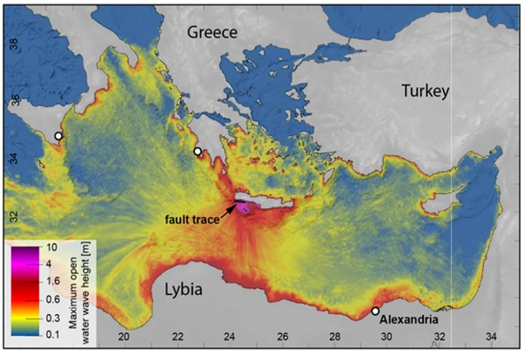
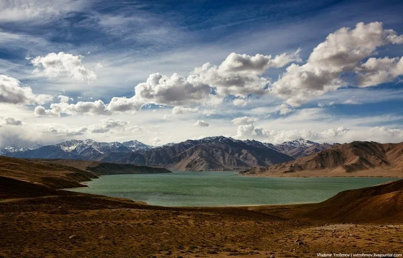
Mega-Tsunami in the Mediterranean (around 5,000 years ago)
This map shows the modeled wave heights of the tsunamis on the coasts in the eastern Mediterranean Sea, which were triggered by the earthquake on July 21, 365. Credit: Richard Ott (www.miragenews.com)
The collapse of the volcanic island of Santorini in the Aegean Sea likely triggered a massive tsunami that affected coastal civilizations in the Eastern Mediterranean. This event could have influenced the decline of the Minoan civilization and impacted societies in the region.
The Great Lisbon Earthquake (1755)
The Great Lisbon Earthquake (1755):
The earthquake that struck Lisbon, Portugal in 1755 not only caused widespread destruction but also influenced Enlightenment thinking. The event prompted discussions on natural disasters, religion, and the role of government in disaster response.
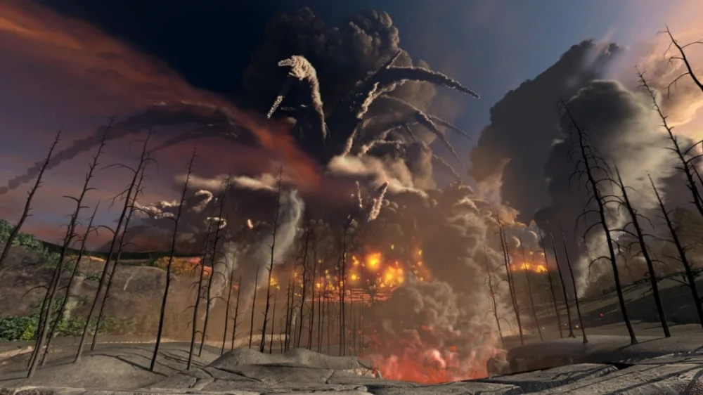
Mount Tambora Eruption (1815)
Mount Tambora Eruption (1815)
The eruption of Mount Tambora in Indonesia is considered the most powerful volcanic eruption in recorded history. The resulting “Year Without a Summer” in 1816 led to widespread crop failures, food shortages, and social unrest in various parts of the world.
San Francisco Earthquake (1906)
San Francisco Earthquake (1906)
The 1906 earthquake in San Francisco not only caused significant destruction but also led to changes in building codes and urban planning. The disaster influenced seismic design principles that are still applied today.
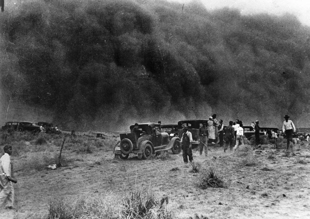
Dust Bowl (1930s)
Dust Bowl (1930s)
A combination of severe drought and poor land management practices led to the Dust Bowl in the central United States during the 1930s. This environmental catastrophe caused widespread crop failures, economic hardship, and forced migrations, impacting the lives of millions.
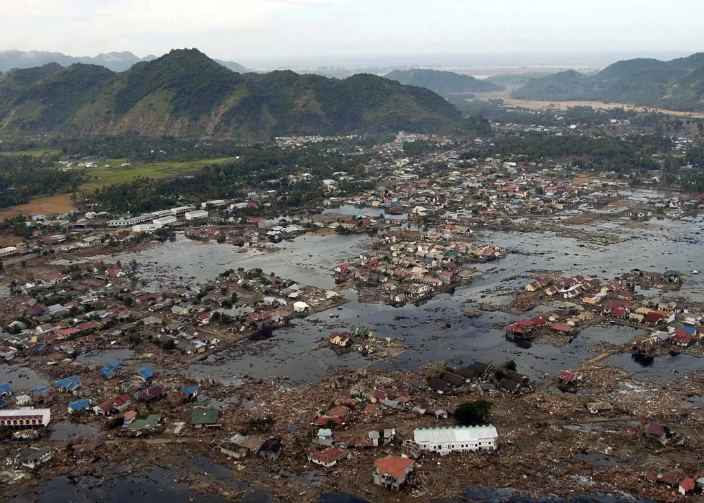
Indian Ocean Earthquake and Tsunami (2004)
050102-N-9593M-040.Indian Ocean (Jan. 2, 2005) – A village near the coast of Sumatra lays in ruin after the Tsunami that struck South East Asia. Helicopters assigned to Carrier Air Wing Two (CVW-2) and Sailors from USS Abraham Lincoln (CVN 72) are conducting humanitarian operations in the wake of the Tsunami that struck South East Asia. The Abraham Lincoln Carrier Strike Group is currently operating in the Indian Ocean off the waters of Indonesia and Thailand. U.S. Navy photo by Photographer’s Mate 2nd Class Philip A. McDaniel (RELEASED).
The massive undersea earthquake off the coast of Sumatra in 2004 triggered a devastating tsunami that affected multiple countries bordering the Indian Ocean. The event highlighted the need for improved early warning systems and international cooperation in disaster response.
Haiti Earthquake (2010)
A poor neighbourhood shows the damage after an earthquake measuring 7 plus on the Richter scale rocked Port au Prince Haiti just before 5 pm yesterday, January 12, 2009.
The earthquake in Haiti resulted in widespread devastation and highlighted the vulnerability of certain regions to seismic activity. The disaster drew attention to issues of poverty, infrastructure, and the challenges of disaster recovery in developing nations.
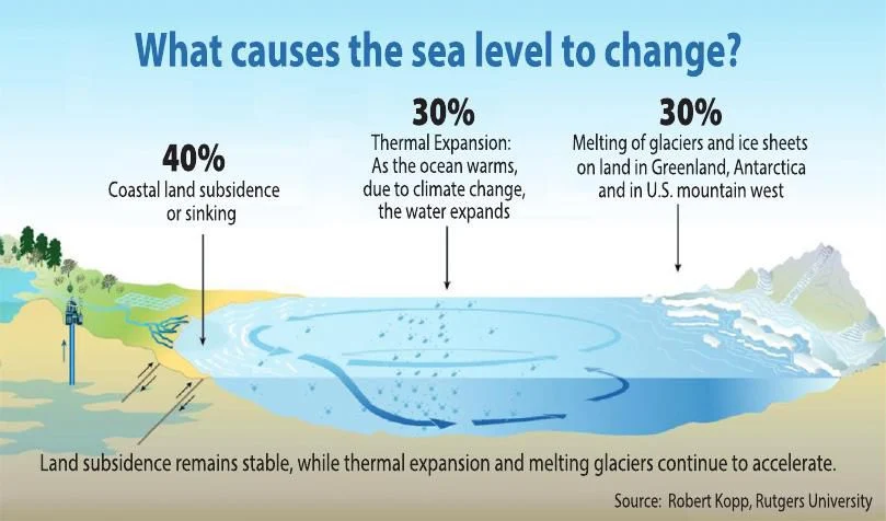
Climate Change and Sea Level Rise
Long-term geologic processes, such as climate change and sea level rise, are impacting coastlines and low-lying areas. This has implications for human settlements, agriculture, and global geopolitics as nations adapt to changing environmental conditions.
In retrospect, the intricate interplay between geological forces and the human journey is evident in the ten pivotal events explored. These geological phenomena, spanning epochs and continents, have etched their influence on the collective history of our species. From the ancient echoes of Toba’s eruption to the contemporary ripples of climate change, the Earth’s dynamic nature has been an enduring protagonist in our story.
As we reflect on these geologic events, it becomes clear that they are not mere footnotes in history but rather keystones that have shaped the very foundations of human civilization. The Toba Supervolcano, the tremors of Lisbon, the Dust Bowl’s winds, and the silent rise of sea levels—all have contributed to the intricate mosaic of our shared past.
Moreover, these events have not only left physical imprints on the landscape but have also influenced the collective psyche of humanity. They have prompted philosophical reflections, inspired advancements in science and technology, and catalyzed societal shifts in the wake of disaster.
Looking forward, these geological chapters offer valuable lessons. They underscore the importance of understanding and adapting to the dynamic nature of our planet. As we grapple with contemporary challenges like climate change, these historical events serve as cautionary tales and sources of inspiration for resilience, innovation, and global cooperation.
In closing, the story of human history is inseparable from the geological forces that have shaped it. The Earth, with its seismic whispers and climatic orchestrations, continues to be an active participant in our unfolding narrative. Through an appreciation of these geologic events, we gain not only a deeper understanding of our past but also a clearer perspective on the challenges and opportunities that lie ahead. As stewards of this planet, it is our responsibility to heed the lessons of history and navigate the ever-changing terrain with wisdom and foresight.
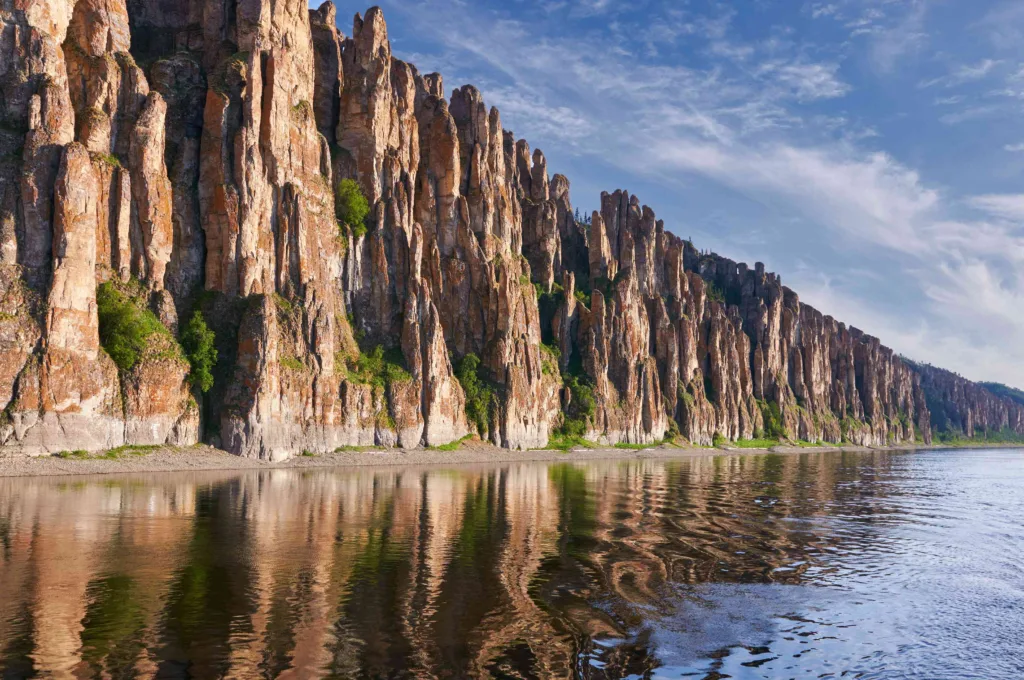
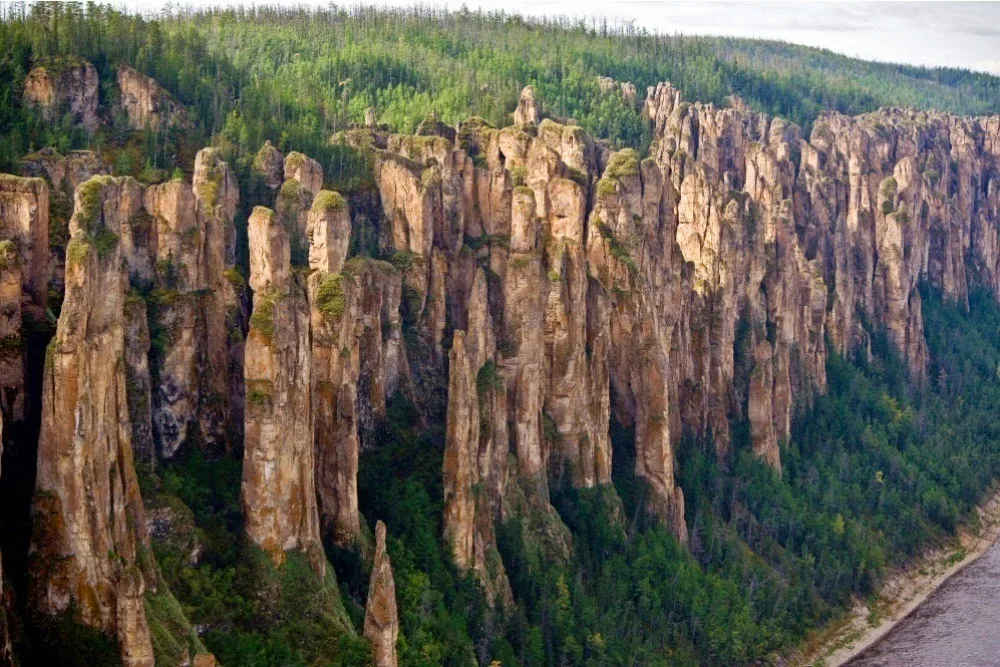
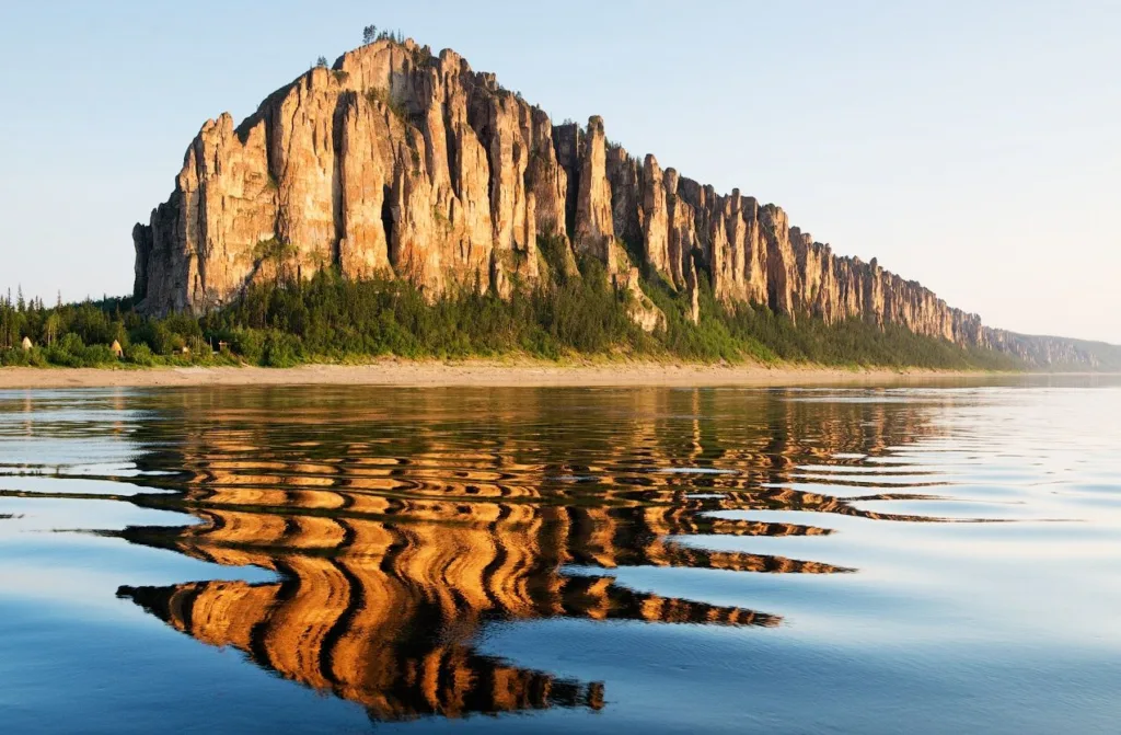
The Lena Pillars are a natural rock formation along the banks of the Lena River in the Sakha Republic (Yakutia), Russia. This geological formation is known for its stunning vertical cliffs that rise as high as 100 meters (328 feet) from the riverbank. The pillars are composed of limestone and shale and have been shaped by the erosive forces of the Lena River over millions of years.
The Lena Pillars, Russia
Location: The Lena Pillars are located in the central part of the Sakha Republic in eastern Siberia, Russia. The closest settlement is the city of Pokrovsk, and the regional center is Yakutsk.
UNESCO World Heritage Site: In 2012, the Lena Pillars Nature Park was inscribed on the UNESCO World Heritage List. The site was recognized for its outstanding natural beauty and the presence of unique and diverse ecosystems, including the permafrost-affected environment.
Flora and Fauna: The Lena Pillars Nature Park is home to a variety of plant and animal species adapted to the harsh climatic conditions of the region. The park provides habitat for species like reindeer, moose, brown bears, and various bird species.
Cultural Significance: The Lena Pillars are not only a natural wonder but also hold cultural significance for the indigenous people of the region, including the Sakha (Yakut) people. The area is rich in folklore and legends associated with the pillars.
Accessibility: While the Lena Pillars are a remote and challenging destination to reach due to the harsh climate and limited infrastructure, they attract scientists, nature enthusiasts, and tourists who are willing to explore this unique and pristine environment.
Visitors to the Lena Pillars can experience the breathtaking scenery, take boat trips along the Lena River, and explore the surrounding wilderness. The site is a testament to the Earth’s geological history and the forces that have shaped its landscapes over millions of years.
Geological Formation of Lena Pillars
The Lena Pillars, Russia
The geological formation of the Lena Pillars is a result of a complex process that spans millions of years. The pillars are primarily composed of alternating layers of limestone and shale, and their formation can be explained through the following steps:
Deposition of Sediments:
Around 540 million years ago, during the Middle Cambrian period, the area that is now the Lena Pillars was covered by a shallow sea.
Over time, sediments such as clay, silt, sand, and organic matter accumulated at the bottom of this sea.
Compaction and Lithification:
The accumulated sediments experienced compaction under the weight of the overlying layers. This compaction expelled water and air from the sediments, causing them to become more compact and solid.
The process of lithification, where loose sediments turn into solid rock, occurred. This resulted in the formation of layers of sedimentary rock.
Formation of Limestone and Shale:
The sediments that make up the Lena Pillars include limestone and shale.
Limestone is formed mainly from the accumulation of marine skeletal debris, such as shells and coral fragments. It consists primarily of the mineral calcite.
Shale, on the other hand, is formed from the compaction of fine-grained sediments like clay and silt. It is characterized by its layered structure.
Subsequent tectonic activity led to the uplift of the region, exposing the sedimentary layers to the surface.
The Lena River, flowing through the region, played a crucial role in the erosional processes that shaped the pillars. The river gradually eroded the softer layers of shale, leaving behind the more resistant layers of limestone as tall, vertical columns.
Permafrost Influence:
The Lena Pillars are located in a region with a harsh climate, characterized by permafrost (permanently frozen ground).
Permafrost affects the stability of the rocks and contributes to the preservation of the pillars by minimizing erosion from factors like soil movement.
The result of these geological processes is the striking landscape of the Lena Pillars, featuring tall, slender columns of limestone standing along the Lena River. The alternating layers of resistant limestone and softer shale create a visually stunning and unique natural formation, making the Lena Pillars a remarkable geological and scenic wonder.
Location and Geography
The Lena Pillars, Russia
Geographical Location: The Lena Pillars are situated along the banks of the Lena River in the Sakha Republic (also known as Yakutia), which is in the central part of eastern Siberia, Russia. The exact coordinates are approximately between 60.7124° N latitude and 127.3285° E longitude. The closest settlement to the Lena Pillars is the city of Pokrovsk, and the regional center is Yakutsk.
Lena River: The Lena River, one of the longest rivers in the world, plays a crucial role in the geographical setting of the Lena Pillars. The pillars are aligned along the riverbanks, rising vertically from the water’s edge. The Lena River itself is significant, flowing for over 4,000 kilometers (2,500 miles) from its source in the Baikal Mountains to the Laptev Sea in the Arctic Ocean.
Surrounding Landscape: The landscape around the Lena Pillars is characterized by a diverse and pristine environment. Here are some key features:
Taiga Forests: The region is part of the vast Siberian taiga, characterized by dense coniferous forests dominated by species like spruce, pine, and larch. The taiga is an essential part of the Siberian ecosystem, providing habitat for a variety of wildlife.
Permafrost: The Lena Pillars are located in an area with a harsh continental climate and permafrost, which is permanently frozen ground. Permafrost influences the vegetation, hydrology, and stability of the landscape.
Wildlife: The area is home to diverse wildlife adapted to the cold climate, including reindeer, moose, wolves, brown bears, and various bird species. The Lena Pillars Nature Park provides a protected habitat for these species.
Unique Ecosystems: The Lena Pillars Nature Park, where the rock formation is located, encompasses not only the pillars themselves but also a range of ecosystems. These ecosystems include riverbanks, floodplains, and diverse plant communities.
UNESCO World Heritage Site: In 2012, the Lena Pillars Nature Park was inscribed as a UNESCO World Heritage Site. The designation recognizes not only the unique geological features of the pillars but also the outstanding natural beauty and ecological significance of the surrounding area.
Visitors to the Lena Pillars can experience the beauty of this remote and pristine landscape by taking boat trips along the Lena River, exploring the surrounding forests, and witnessing the striking geological formations set against the backdrop of the Siberian wilderness. The combination of the river, forests, and unique geological features makes the Lena Pillars a captivating destination for nature enthusiasts and researchers alike.
UNESCO World Heritage Site of Lena Pillars
The Lena Pillars, Russia
The Lena Pillars were designated as a UNESCO World Heritage Site in 2012, and this recognition was based on several criteria that highlight the outstanding universal value of the site. UNESCO considers cultural and natural properties for inclusion on the World Heritage List, and the Lena Pillars met specific criteria that make it worthy of this prestigious designation.
The Lena Pillars received UNESCO recognition under the natural criteria, specifically:
Criterion (vii): Natural Beauty:
The Lena Pillars are acknowledged for their exceptional natural beauty. The towering limestone columns along the banks of the Lena River create a breathtaking and visually striking landscape. The combination of the vertical rock formations, the meandering river, and the surrounding pristine wilderness contributes to the aesthetic appeal of the site.
Criterion (viii): Geological and Geomorphological Features:
The geological formation of the Lena Pillars is a unique and outstanding example of the Earth’s history and processes. The site represents an extraordinary display of geological and geomorphological features, showcasing the effects of erosion by the Lena River on alternating layers of limestone and shale. The pillars themselves stand as a testament to the intricate forces that have shaped the Earth’s surface over millions of years.
Criterion (ix): Ecological Significance:
The Lena Pillars and the surrounding area, known as the Lena Pillars Nature Park, are ecologically significant. The site provides habitat for diverse plant and animal species adapted to the challenging climatic conditions of the region. The ecosystems within the park, including riverine and forest ecosystems, contribute to the overall ecological richness of the area.
Criterion (x): Biodiversity and Conservation:
The Lena Pillars Nature Park is recognized for its biodiversity and conservation value. The site supports a variety of wildlife, including species like reindeer, moose, brown bears, and various bird species. The conservation efforts in place contribute to the protection of these species and their habitats.
The combination of these criteria showcases the exceptional natural values of the Lena Pillars. The site not only serves as a stunning example of natural beauty but also provides insights into geological processes and supports diverse ecosystems. The UNESCO World Heritage designation helps raise awareness of the global significance of the Lena Pillars and emphasizes the need for its protection and conservation for future generations.
Tourism and Recreation
The Lena Pillars, Russia
As a UNESCO World Heritage Site and a breathtaking natural wonder, the Lena Pillars attract tourists, researchers, and nature enthusiasts from around the world. The site offers a range of activities and opportunities for exploration, making it a unique destination for those interested in the intersection of natural beauty, geology, and cultural history.
Here are some aspects of tourism and recreation associated with the Lena Pillars:
Boat Trips along the Lena River:
One of the most popular ways to experience the Lena Pillars is by taking boat trips along the Lena River. These excursions provide visitors with a close-up view of the towering limestone columns rising from the riverbanks.
Nature Walks and Hiking:
The Lena Pillars Nature Park offers opportunities for nature walks and hiking. Exploring the surrounding forests and landscapes allows visitors to appreciate the unique flora and fauna of the region.
Photography:
The stunning and dramatic scenery of the Lena Pillars makes it a paradise for photographers. The interplay of light and shadow on the vertical rock formations, especially during sunrise and sunset, creates mesmerizing photo opportunities.
Cultural Experiences:
The region around the Lena Pillars is inhabited by the Sakha (Yakut) people, and visitors may have the chance to engage in cultural experiences, learn about local traditions, and explore the folklore associated with the pillars.
Scientific Research:
The Lena Pillars also attract scientists and researchers interested in geology, geomorphology, and ecology. The site provides a unique opportunity to study the geological processes that shaped the pillars and the surrounding landscape.
Winter Activities:
In the winter, when the region is covered in snow and ice, the Lena Pillars take on a different, yet equally enchanting, appearance. Winter activities, such as snowmobiling and dog sledding, provide a different perspective on the site.
Camping and Outdoor Adventure:
For those seeking more adventurous experiences, camping is an option in the Lena Pillars Nature Park. The surrounding wilderness offers opportunities for outdoor activities such as birdwatching, fishing, and wildlife observation.
Visitor Centers and Interpretive Facilities:
Visitor centers and interpretive facilities provide information about the geological history of the Lena Pillars, the surrounding ecosystems, and the cultural significance of the site. Educational programs and guided tours are often available.
While tourism at the Lena Pillars is growing, the remote location and challenging climate ensure that the site retains a sense of pristine wilderness. Efforts are made to balance the interest of visitors with the need for conservation to preserve the ecological and geological integrity of this unique natural treasure.
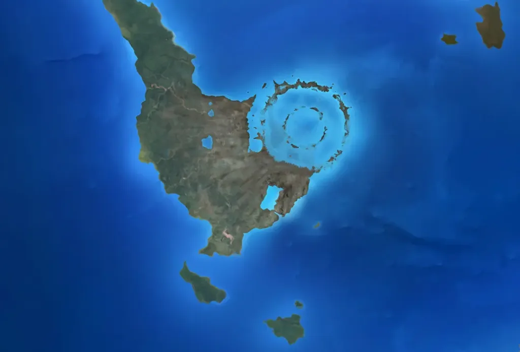
Earth has been shaped by numerous extraterrestrial collisions over its geological history, leaving behind scars in the form of impact craters. These craters serve as tangible evidence of powerful forces from space shaping the planet’s landscape. Each impact event carries a unique story, contributing to our understanding of Earth’s evolution. Here, we explore 10 famous impact craters that have left an indelible mark on the planet, ranging from the catastrophic event linked to the demise of the dinosaurs to ancient collisions that date back billions of years. From the iconic Chicxulub Crater associated with a mass extinction event to the Barringer Crater in Arizona, a stunning testament to the violent nature of celestial encounters, these craters offer a window into Earth’s dynamic history and the relentless cosmic forces that have influenced its course. Join us on a journey to uncover the mysteries behind these geological formations and the profound impact they have had on our planet’s story.
Chicxulub Crater (Mexico)
“mark garlick/science photo library/getty images: illustration depicting the chicxulub crater, emerging shortly off the coast of modern-day mexico. the asteroid thought to have caused this impact is widely believed to be the catalyst for the extinction of dinosaurs and various species during that era.”
The Chicxulub Crater is the most famous impact crater and is associated with the mass extinction event that occurred around 66 million years ago, leading to the extinction of the dinosaurs. It is located on the Yucatán Peninsula in Mexico.
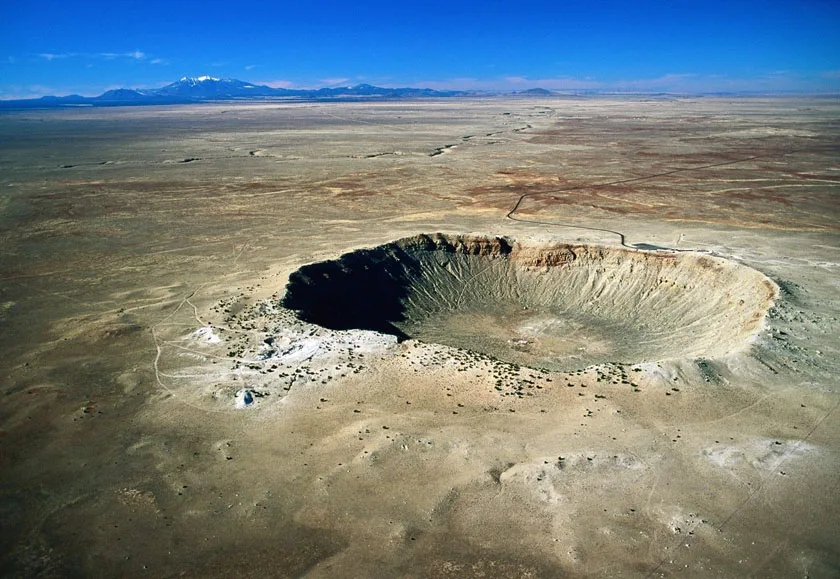
Also known as Meteor Crater, this is one of the best-preserved impact craters on Earth. It was formed around 50,000 years ago by the impact of an iron meteorite and is located near Winslow, Arizona.
Vredefort Crater (South Africa)
Vredefort Crater (South Africa)
This is the largest verified impact crater on Earth, with an estimated diameter of about 300 kilometers. It was formed over 2 billion years ago and is one of the oldest known impact structures.
Sudbury Basin (Canada)
Sudbury Basin (Canada)
The Sudbury Basin is one of the largest impact structures on Earth, located in Ontario, Canada. It was formed about 1.8 billion years ago and is associated with the impact that created the Sudbury Igneous Complex.
Manicouagan Crater (Canada)
Manicouagan Crater (Canada)
Located in Quebec, Canada, this crater was formed over 200 million years ago. It is now a prominent feature, with a ring-shaped lake occupying a significant portion of the crater.
Popigai Crater (Russia)
Popigai Crater (Russia)
The Popigai Crater is one of the largest impact structures on Earth, with a diameter of about 100 kilometers. It was formed approximately 35 million years ago in Siberia, Russia.
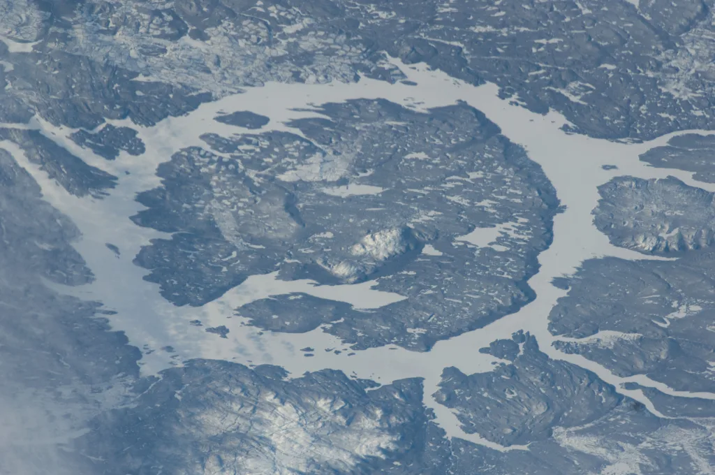
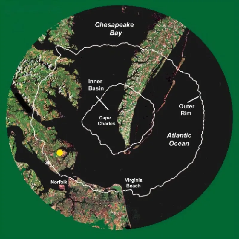
Chesapeake Bay Impact Crater (USA)
Chesapeake Bay Impact Crater (USA)
This crater is buried beneath the Chesapeake Bay and the surrounding region on the east coast of the United States. It was formed around 35 million years ago and was discovered in the 1980s.
Acraman Crater (Australia)
Acraman Crater (Australia)
This crater is located in South Australia and was formed around 580 million years ago. It is one of the oldest known impact structures on Earth.
Haughton Crater (Canada)
Haughton Crater (Canada)
Situated on Devon Island in the Arctic Circle, the Haughton Crater was formed about 23 million years ago. It is one of the most well-preserved impact craters on Earth.
Karakul Crater (Tajikistan)
Karakul Crater (Tajikistan)
This impact crater is located in the Pamir Mountains in Tajikistan. It was formed about 25 million years ago and is relatively well-preserved.
In conclusion, the Earth bears witness to the enduring impact of celestial collisions through the presence of numerous craters scattered across its surface. These scars tell stories of cataclysmic events, ancient encounters, and the ever-changing nature of our planet. From the infamous Chicxulub Crater, a harbinger of the dinosaurs’ demise, to the well-preserved Barringer Crater in Arizona, each crater is a testament to the powerful forces that have shaped Earth over millions and even billions of years.
These impact craters not only offer insights into the geological history of our planet but also serve as crucial windows into the broader cosmic narrative. They provide valuable clues about the nature of extraterrestrial bodies that have interacted with Earth and the profound consequences of such collisions. As we continue to explore and study these craters, we gain a deeper understanding of the interconnectedness between Earth and the cosmos, highlighting the dynamic and sometimes violent dance between our planet and celestial bodies. The study of impact craters remains a fascinating avenue for scientific inquiry, unraveling mysteries that extend far beyond our terrestrial boundaries.
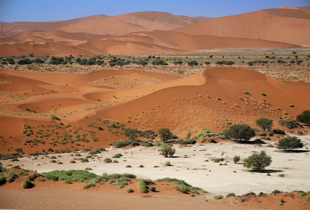
Namib-Naukluft National Park is a vast and diverse protected area located in the southwestern part of Namibia, Africa. It is renowned for its stunning and varied landscapes, including the iconic red sand dunes of Sossusvlei, rugged mountains, and vast desert plains. The park is a key component of the Namib Desert, one of the oldest deserts on the planet.
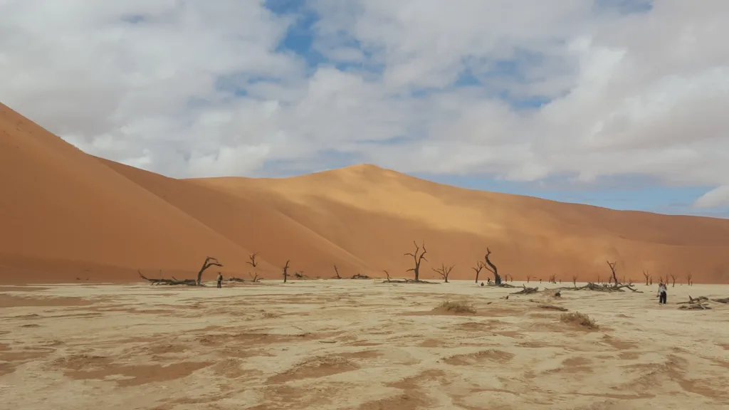
The dead camelthorn trees against red dunes and blue sky in Deadvlei, Sossusvlei, NamibiaNamib-Naukluft National Park
Location and Size: The Namib-Naukluft National Park is situated in the Namib Desert, covering an extensive area of approximately 49,768 square kilometers (19,216 square miles). It is one of the largest national parks in Africa and encompasses various distinct ecological zones.
Importance for Biodiversity and Conservation:
Diverse Ecosystems: The park is home to a wide range of ecosystems, from the towering sand dunes to rocky mountain outcrops, gravel plains, and ephemeral rivers. This diversity supports a variety of plant and animal species adapted to harsh desert conditions.
Endemism: Namib-Naukluft National Park is crucial for the conservation of numerous endemic species that have adapted specifically to the unique desert environment. These include specialized plant species and desert-adapted wildlife, such as oryx, springbok, and the Namib Desert beetle.
Conservation of Desert Adaptations: The park plays a vital role in studying and preserving the adaptations of flora and fauna to extreme arid conditions. Understanding these adaptations can provide valuable insights for conservation efforts in other arid regions globally.
Cultural Significance: The park is not only a biodiversity hotspot but also holds cultural significance. It is home to the indigenous Himba people, who have adapted their lifestyles to the challenges posed by the desert environment.
Tourism and Education: Namib-Naukluft National Park attracts tourists from around the world who come to witness its spectacular landscapes and unique desert life. Responsible tourism contributes to the park’s conservation efforts and raises awareness about the importance of preserving fragile ecosystems.
International Recognition: The Namib Desert, including the Namib-Naukluft National Park, has been designated a UNESCO World Heritage Site, recognizing its outstanding universal value in terms of biodiversity, geology, and desert ecology.
Preserving the Namib-Naukluft National Park is crucial not only for the survival of unique desert species but also for maintaining the ecological balance of the entire Namib Desert ecosystem. It serves as a living laboratory for scientific research, education, and a testament to the resilience of life in some of the world’s most challenging environments.
Geography and Landforms
Namib-Naukluft National Park
Namib-Naukluft National Park is characterized by a diverse range of geographical features and landforms, contributing to its unique and picturesque landscape. Here are some key aspects of the geography and landforms within the park:
Sand Dunes:
The park is most famous for its towering red sand dunes, particularly in the Sossusvlei and Deadvlei areas. These dunes, some of which are among the tallest in the world, create a mesmerizing and ever-changing desert landscape.
Sossusvlei and Deadvlei:
Sossusvlei is a salt and clay pan surrounded by high red dunes, while Deadvlei is a white clay pan dotted with ancient, dead camel thorn trees. Both areas are iconic and draw visitors seeking to experience the surreal beauty of the desert.
Naukluft Mountains:
The Naukluft Mountains, part of the larger Naukluft Mountain Range, dominate the eastern part of the park. These mountains feature rugged terrain, deep canyons, and spectacular rock formations, providing a stark contrast to the sandy desert expanses.
Kuiseb Canyon:
The Kuiseb Canyon, carved by the Kuiseb River, is another notable landform in the park. The canyon exhibits dramatic cliffs and is an important corridor for wildlife movement in the region.
Tsondab Valley:
Tsondab Valley is an ancient river valley characterized by gravel plains and low rocky hills. This area showcases the park’s varied topography and is home to diverse desert-adapted flora and fauna.
Moon Landscape:
The “Moon Landscape” is a unique geological formation near the Swakop River. Erosion has created a lunar-like terrain with deep gorges, sharp ridges, and a surreal, otherworldly appearance.
Gravel Plains:
Large expanses of gravel plains are spread throughout the park. These plains are often interspersed with desert-adapted vegetation and are an important habitat for various species.
Namib Desert:
The park is situated within the Namib Desert, one of the oldest deserts globally. The desert’s vast expanse is characterized by arid conditions, minimal vegetation, and unique adaptations by plants and animals to survive in this harsh environment.
The combination of these diverse landforms creates a visually stunning and ecologically significant environment. The park’s geography not only attracts tourists but also serves as a living laboratory for scientists studying desert ecosystems and adaptations. It is a testament to the incredible resilience of life in extreme environments.
Sossusvlei and Deadvlei
Namib-Naukluft National Park
Sossusvlei: Sossusvlei is a clay and salt pan surrounded by high red sand dunes, situated in the southern part of the Namib Desert within the Namib-Naukluft National Park. It is one of the most iconic and photographed landscapes in Namibia and is renowned for its towering sand dunes that reach heights of up to 300 meters (almost 1,000 feet). The name “Sossusvlei” roughly translates to “dead-end marsh,” and it refers to the fact that the Tsauchab River, which occasionally fills the vlei (pan), never reaches the Atlantic Ocean.
Key features of Sossusvlei include:
Sand Dunes: The dunes surrounding Sossusvlei are among the highest in the world. Dune 45 is particularly famous, and many visitors climb it to witness breathtaking panoramic views of the surrounding desert landscape.
Vlei (Pan): Sossusvlei itself is a clay and salt pan that only fills with water after rare, heavy rainfall. When dry, the pan’s surface transforms into a cracked, white clay, providing a striking contrast to the red sand dunes.
Wildlife: Despite its seemingly harsh conditions, Sossusvlei is home to some resilient desert-adapted wildlife, including oryx, springbok, and various bird species.
Deadvlei: Deadvlei, located near Sossusvlei, is a surreal and otherworldly landscape that is often considered one of the most photogenic places in the Namib-Naukluft National Park. The name “Deadvlei” translates to “dead marsh” or “dead pan,” reflecting the stark, dry conditions of this ancient clay pan.
Key features of Deadvlei include:
White Clay Pan: Deadvlei features a white clay pan surrounded by some of the tallest red sand dunes in the world. The pan is dotted with the skeletal remains of ancient camel thorn trees, providing a haunting and starkly beautiful scene.
Dead Camel Thorn Trees: The blackened, dead trees in Deadvlei are estimated to be around 900 years old. They stand as eerie sentinels against the backdrop of the pan and dunes, having died due to changes in the climate and the encroachment of sand dunes that blocked the Tsauchab River from reaching the area.
Photographic Appeal: The contrasting colors of the white pan, red dunes, and dark tree skeletons make Deadvlei an extraordinary subject for photographers. The play of light and shadows, especially during sunrise and sunset, creates a visually stunning and ethereal atmosphere.
Both Sossusvlei and Deadvlei are popular destinations for tourists and photographers, offering a unique and captivating experience of the Namib Desert’s natural beauty and geological wonders. The delicate balance of life and death in these landscapes contributes to the park’s ecological significance and its status as a UNESCO World Heritage Site.
Cultural and Historical Significance
Namib-Naukluft National Park
While Namib-Naukluft National Park is primarily known for its stunning natural landscapes and diverse ecosystems, it also holds cultural and historical significance, particularly in relation to the indigenous people of the region.
Cultural Significance:
Himba People: The park is home to the Himba people, an indigenous group known for their semi-nomadic pastoralist lifestyle and unique cultural practices. The Himba have adapted their way of life to the challenges of the arid environment, and visitors to the park may have the opportunity to learn about their customs, traditions, and intricate hairstyles, often adorned with a mixture of ochre and butterfat.
Living Desert Experience: Some guided tours in the park offer a “Living Desert Experience,” where knowledgeable guides provide insights into the desert-adapted flora and fauna. This educational experience often includes discussions on how these adaptations have been utilized by indigenous people for centuries.
Historical Significance:
Archaeological Sites: The Namib Desert, including areas within the national park, has revealed archaeological sites with evidence of early human habitation. These sites contribute to the understanding of the region’s prehistoric cultures and the ways in which ancient populations interacted with the desert environment.
Colonial History: The broader region has a colonial history, with European influences impacting the indigenous communities. Understanding this history is crucial for a comprehensive perspective on the cultural and social dynamics of the area.
Trade Routes: The Namib Desert has historically been traversed by trade routes, connecting inland regions with the coastal areas. These routes were used for the exchange of goods, including salt and other resources, and they played a significant role in the historical commerce of the region.
While the cultural and historical aspects of Namib-Naukluft National Park may not be as prominent as its natural wonders, they add depth to the overall experience for visitors. Learning about the traditional practices of the Himba people and the historical interactions between different communities and the desert landscape enhances the appreciation for the interconnectedness of human culture and the environment in this remarkable part of Namibia.
Tourism in Namib-Naukluft National Park
Namib-Naukluft National Park
Visitor Center: The park has a visitor center that serves as an information hub for tourists. Visitors can obtain maps, brochures, and guidance on the park’s attractions, regulations, and safety measures.
Sossusvlei and Deadvlei: These iconic locations are major attractions within the park. Tourists often visit to witness the towering red sand dunes, explore the clay pans, and photograph the unique landscapes.
Activities: Popular activities for tourists include guided nature walks, wildlife viewing, and stargazing. Guided tours by knowledgeable locals provide insights into the desert’s flora, fauna, and geological features.
Hot Air Balloon Safaris: Some tour operators offer hot air balloon safaris, providing a unique and breathtaking perspective of the vast desert landscapes, including the dunes of Sossusvlei.
Adventure Activities: The park offers opportunities for adventure enthusiasts, such as 4×4 self-drive routes and hiking trails. The Naukluft Mountains provide a rugged terrain for those seeking a more challenging outdoor experience.
Camping and Accommodations: There are camping facilities within the park, allowing visitors to immerse themselves in the desert environment. Additionally, there are nearby lodges and accommodations for those seeking more comfort.
Visitor Information:
Entrance Fees: There is an entrance fee to access the park, and fees may vary for international and Namibian visitors. It’s advisable to check the latest fee information and park regulations before planning a visit.
Park Hours: The park typically opens early in the morning and closes in the evening. It’s important to be aware of the park’s operating hours to plan activities accordingly.
Weather Considerations: The Namib Desert can experience extreme temperatures, especially during the day. Visitors should be prepared for hot conditions and bring sufficient water, sunscreen, and protective clothing. Additionally, temperatures can drop significantly at night.
Guided Tours: While some areas are accessible by self-drive, guided tours with knowledgeable local guides are recommended for a more in-depth and educational experience.
Conservation and Respect: Visitors are encouraged to adhere to conservation principles and respect the fragile desert ecosystem. This includes staying on designated paths, not disturbing wildlife, and following leave-no-trace principles.
Accommodation Reservations: It’s advisable to make accommodation reservations in advance, especially during peak tourist seasons, to ensure availability.
Permits for Certain Activities: Depending on the activities planned, such as guided tours or special experiences, visitors may need specific permits. Checking and obtaining necessary permits in advance is important.
Before visiting Namib-Naukluft National Park, it’s recommended to check with official park authorities, gather updated information, and plan the trip accordingly to make the most of the experience while respecting the environment and local regulations.
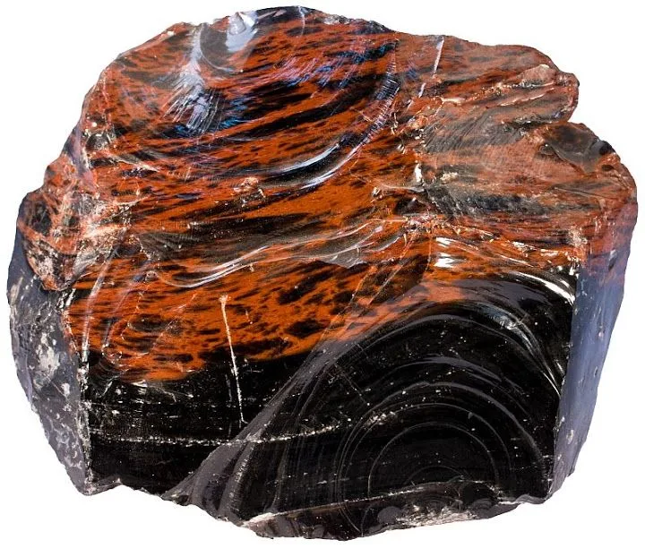
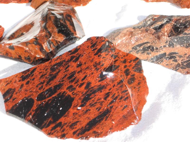
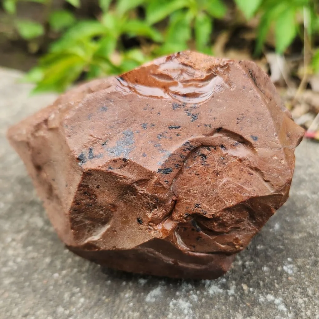
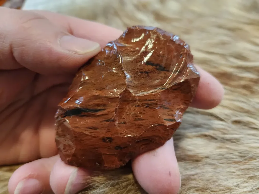
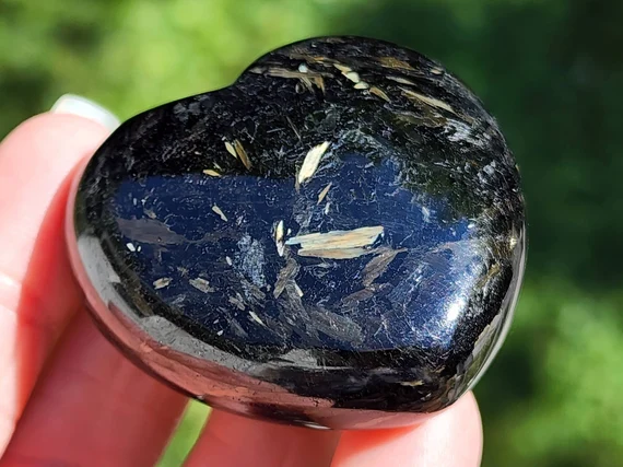
Pumpkin Obsidian is a type of natural glass that is formed when lava high in silica content cools quickly. It is a variety of obsidian, which is a volcanic glass that typically has a smooth, glossy appearance. What sets Pumpkin Obsidian apart is its distinctive coloration, which resembles the rich, warm hues of a pumpkin.
Key characteristics of Pumpkin Obsidian include its deep orange to reddish-brown color, often with darker streaks or patterns. This unique coloring is a result of the presence of iron and other mineral impurities in the volcanic glass. The name “obsidian” itself is derived from a Roman named Obsius, who is believed to have discovered a similar type of volcanic glass in Ethiopia.
Obsidian, including Pumpkin Obsidian, has been used by various cultures throughout history for making tools, weapons, and ceremonial objects due to its sharp edges when fractured and its relative hardness. In more recent times, it has gained popularity as a gemstone for jewelry and ornamental purposes.
It’s important to note that the term “Pumpkin Obsidian” is primarily used in the context of lapidary and gemstone enthusiasts to describe this specific variety of obsidian with its distinctive pumpkin-like coloration. The geological processes that lead to the formation of obsidian, including Pumpkin Obsidian, are fascinating and showcase the beauty that can arise from volcanic activity.
Geological Formation
Pumpkin Obsidian, like other types of obsidian, is formed through volcanic processes. Here’s a step-by-step explanation of the geological formation of Pumpkin Obsidian:
Volcanic Activity:
The formation of Pumpkin Obsidian begins with volcanic activity. When magma (molten rock) rises to the Earth’s surface during an eruption, it’s exposed to rapid cooling.
High Silica Content:
Pumpkin Obsidian, like all types of obsidian, is characterized by its high silica content. Silica (SiO2) is a key component of the volcanic glass, and the high concentration contributes to the glassy texture of obsidian.
Rapid Cooling:
The crucial factor in the formation of obsidian is the rapid cooling of the lava. Unlike slow-cooling igneous rocks that allow mineral crystals to form, obsidian cools so quickly that mineral crystals don’t have time to develop. This rapid cooling results in the formation of an amorphous, glassy substance.
Mineral Impurities:
The coloration of Pumpkin Obsidian, in particular, is influenced by the presence of mineral impurities. Iron and other trace elements contribute to the characteristic orange to reddish-brown hues. These impurities can create streaks or patterns in the glass.
Lack of Crystalline Structure:
Obsidian lacks a crystalline structure due to its rapid cooling process. Instead, it has a random arrangement of atoms, creating a glassy texture.
Fracture and Sharp Edges:
When obsidian, including Pumpkin Obsidian, fractures, it creates sharp edges. This property made obsidian a valuable material for toolmaking and weaponry in many ancient cultures.
Key Locations:
Obsidian deposits, including Pumpkin Obsidian, can be found in various volcanic regions around the world. Some notable locations include:
United States: Obsidian can be found in areas with a volcanic history, such as the American Southwest (e.g., Oregon, California, and Nevada).
Mexico: Several Mexican states have obsidian deposits, and Mexico has a rich history of obsidian use.
New Zealand: Obsidian is found in areas with past or present volcanic activity.
It’s important to note that while obsidian is widespread, the Pumpkin Obsidian variety with its specific coloration might be more localized. Lapidary enthusiasts often seek out specific deposits or sources for the unique Pumpkin Obsidian material.
Physical Characteristics
Pumpkin Obsidian, like other types of obsidian, exhibits distinct physical characteristics that contribute to its unique appearance. Here are some key physical traits of Pumpkin Obsidian:
Color:
The most prominent feature of Pumpkin Obsidian is its rich orange to reddish-brown color. This coloration is a result of mineral impurities, particularly iron oxides, present in the volcanic glass.
Transparency:
Obsidian, including Pumpkin Obsidian, is generally transparent or translucent. The glassy nature of obsidian allows light to pass through to some extent.
Luster:
Pumpkin Obsidian has a glassy luster, giving it a smooth and reflective surface when polished. The lack of crystalline structure contributes to its glass-like sheen.
Texture:
The texture of Pumpkin Obsidian is smooth and often described as glassy. When cut and polished, it can have a glossy appearance that enhances its aesthetic appeal.
Fracture and Conchoidal Cleavage:
Obsidian, including Pumpkin Obsidian, is known for its characteristic conchoidal fracture. When it breaks, it forms smooth, curved surfaces, creating sharp edges. This property made obsidian historically valuable for toolmaking and cutting.
Hardness:
Obsidian is relatively hard, rating around 5 to 5.5 on the Mohs scale of mineral hardness. This hardness contributes to its ability to hold a sharp edge and makes it suitable for various cutting purposes.
Density:
The density of Pumpkin Obsidian is relatively high due to its composition of volcanic glass. However, specific density values may vary based on the mineral impurities present.
Streak:
Obsidian does not have a streak because it is not a mineral with a defined crystalline structure. Streak tests are typically performed on minerals with a powdered form.
Pattern and Inclusions:
Pumpkin Obsidian may display patterns or inclusions, which can add to its visual appeal. These patterns may include darker streaks or patches within the orange to reddish-brown background.
Shape and Size:
In its natural state, Pumpkin Obsidian can occur in various shapes and sizes, depending on the geological conditions and the specific location of its formation. Lapidaries often shape and cut it into cabochons, beads, or other decorative items for use in jewelry.
These physical characteristics contribute to the beauty and uniqueness of Pumpkin Obsidian, making it a sought-after material for both collectors and artisans in the field of lapidary arts.
Cultural and Historical Significance
Obsidian, including Pumpkin Obsidian, has played a significant role in various cultures throughout history due to its unique properties and versatile uses. Here are some aspects of its cultural and historical significance:
Toolmaking and Weapons:
Obsidian has been highly valued for making tools and weapons by many ancient cultures. Its conchoidal fracture allows for the production of sharp-edged blades and arrowheads. The use of obsidian tools dates back to prehistoric times, and archaeological evidence shows its importance in the development of early human societies.
Ritual and Ceremonial Use:
In some cultures, obsidian has been used in rituals and ceremonies. Its reflective and sometimes translucent nature may have contributed to its symbolic significance. The Aztecs, for example, used obsidian mirrors in religious ceremonies.
Trade and Exchange:
Obsidian was a valuable commodity for trade in ancient times. The distribution of obsidian artifacts across different regions often indicates trade routes and networks. Specific types of obsidian, such as Pumpkin Obsidian, might have held special value and been traded over long distances.
Art and Ornamentation:
Obsidian, including its Pumpkin variety, has been used for artistic and ornamental purposes. It has been shaped into beads, cabochons, and carvings for jewelry and decorative items. The unique coloration of Pumpkin Obsidian makes it particularly attractive for these purposes.
Spiritual and Metaphysical Beliefs:
Some cultures attribute spiritual and metaphysical properties to obsidian. It is believed by some to have protective qualities and is used in spiritual practices for grounding and shielding against negative energies.
Archaeological Discoveries:
Obsidian artifacts are valuable for archaeologists studying ancient cultures. The presence of obsidian tools and objects at archaeological sites provides insights into trade networks, technological advancements, and cultural practices of past societies.
Modern Lapidary and Jewelry:
In contemporary times, obsidian, including Pumpkin Obsidian, remains popular in the lapidary and jewelry-making communities. Artisans and collectors appreciate its unique coloration and smooth texture for creating distinctive and aesthetically pleasing pieces.
Symbolism:
The use of obsidian, often associated with sharpness and precision, can carry symbolic meaning in various cultures. Its use in tools and weapons may symbolize strength, while its use in spiritual practices may symbolize protection and grounding.
Overall, Pumpkin Obsidian and obsidian in general have left a lasting impact on human history, reflecting the practical, spiritual, and artistic aspects of the cultures that utilized this volcanic glass.
Lapidary Arts and Jewelry
Lapidary arts involve the cutting, shaping, and polishing of gemstones and other hard materials. Pumpkin Obsidian, being a type of volcanic glass with unique coloration, is a favored material among lapidaries for creating jewelry and ornamental pieces. Here’s how Pumpkin Obsidian is used in lapidary arts and jewelry:
Cabochons:
Lapidaries often cut Pumpkin Obsidian into cabochons, which are polished, convex-shaped gemstones with a smooth, rounded surface. Cabochons are popular for creating jewelry like pendants, earrings, and rings.
Beads:
Pumpkin Obsidian is also fashioned into beads of various shapes and sizes. These beads can be used in necklaces, bracelets, and earrings, providing a unique and earthy aesthetic.
Carvings:
Lapidaries skilled in carving may create intricate designs or sculptures from Pumpkin Obsidian. These carvings can range from small decorative pieces to larger, more elaborate artworks.
Inlay Work:
Inlay work involves setting small pieces of gemstone into a base material to create patterns or images. Pumpkin Obsidian, with its distinctive color, can be used for inlay work in jewelry or other decorative items.
Wire Wrapping:
Wire wrapping is a technique where wire is used to secure and showcase a gemstone without the need for traditional settings. Pumpkin Obsidian cabochons or beads can be incorporated into wire-wrapped jewelry designs.
Combined with Other Gemstones:
Lapidaries often combine Pumpkin Obsidian with other gemstones or materials to create visually appealing contrasts or complementary color schemes in jewelry designs.
Tumbling and Polishing:
Tumbling is a process where rough gemstone material, including Pumpkin Obsidian, is placed in a drum with abrasive grit and tumbled to achieve a smooth and polished finish. This technique is commonly used to prepare stones for further lapidary work or for creating polished stones for various uses.
One-of-a-Kind Pieces:
Pumpkin Obsidian’s unique coloration makes it well-suited for creating one-of-a-kind jewelry pieces. Each gemstone can have its own distinct patterns and shades, adding to the individuality of the finished item.
Custom Jewelry:
Jewelers and artisans may work with clients to create custom pieces using Pumpkin Obsidian. This allows for the incorporation of personal preferences and design ideas into the finished jewelry.
Artistic Expression:
Lapidary arts provide a platform for artistic expression. Artists can explore and experiment with different cuts, shapes, and designs to showcase the natural beauty of Pumpkin Obsidian.
In summary, Pumpkin Obsidian is a versatile material in the hands of lapidaries and jewelry makers, offering a wide range of possibilities for creating unique and visually striking pieces of wearable art. The distinctive coloration and smooth texture make it a popular choice for those seeking jewelry with a natural and earthy appeal.
Nuummite is a rare and unique metamorphic rock that is prized for its distinctive iridescent play of colors. It is primarily composed of two minerals: anthophyllite and gedrite, both of which belong to the amphibole group. Nuummite is known for its deep, lustrous hues, which can include shades of blue, green, gold, and sometimes even red or violet.
Origin: Nuummite is found in only a few locations worldwide. The primary source is the Nuummite deposits in the Precambrian rocks of the Nuuk region in Greenland. Other deposits have been identified in Canada and the United States, but the Greenlandic material is the most sought after.
Appearance: What sets Nuummite apart is its chatoyancy, or the ability to display a cat’s-eye effect. This effect is caused by the presence of reflective minerals oriented in parallel layers within the rock. The play of colors is often reminiscent of the Northern Lights, adding to its allure.
Metaphysical Properties: In the realm of metaphysics and crystal healing, Nuummite is believed to possess spiritual and grounding properties. It is associated with inner power, intuition, and self-discovery. Some people use Nuummite for meditation and to enhance psychic abilities.
Uses: Nuummite is commonly used in the creation of ornamental and lapidary items, including cabochons, beads, and carvings. It is also occasionally used in jewelry, although its relative softness compared to other gemstones requires careful handling to avoid scratches.
Due to its limited availability and unique aesthetic qualities, Nuummite is often considered a collector’s item and is valued for its rarity and beauty. Keep in mind that while some people ascribe metaphysical properties to Nuummite, these beliefs are not scientifically proven, and the stone is primarily appreciated for its geological and aesthetic attributes.
Physical Properties of Nuummite
Nuummite, being a metamorphic rock composed mainly of amphibole minerals, exhibits certain physical properties that contribute to its unique characteristics. Here are some of the key physical properties of Nuummite:
Hardness: Nuummite has a variable hardness ranging between 5 and 6 on the Mohs scale. This puts it in the mid-range of hardness, making it susceptible to scratches and wear over time. It is softer than many popular gemstones, so care is needed to prevent damage.
Color: Nuummite is known for its striking iridescence and can display a wide range of colors. The most common colors include shades of brown, black, gold, green, and blue. The iridescence is often in the form of a chatoyant or cat’s-eye effect, especially when the stone is polished.
Luster: The luster of Nuummite is generally vitreous to slightly resinous. When polished, the surface can exhibit a shiny or glassy appearance.
Transparency: Nuummite is typically opaque, meaning that light does not pass through the stone. The play of colors and chatoyancy is observed on the surface of the stone rather than through it.
Density: The density of Nuummite varies, but it is generally denser than average rocks due to the presence of heavy minerals like anthophyllite and gedrite.
Cleavage: Nuummite exhibits good cleavage in two directions due to its mineral composition. Cleavage refers to the tendency of a mineral to break along specific planes.
Structure: Nuummite is a metamorphic rock with a foliated structure, meaning it has a layered or banded appearance. The layers are often a result of the alignment of mineral grains during the rock’s formation under high-pressure metamorphic conditions.
Understanding these physical properties is crucial for lapidaries, jewelers, and collectors who work with or appreciate Nuummite. It helps in the proper identification, handling, and appreciation of the stone’s unique characteristics.
Chemical Composition of Nuummite
Nuummite is a metamorphic rock composed mainly of two amphibole minerals: anthophyllite and gedrite. The chemical composition of these minerals contributes to the overall composition of Nuummite. Here are the general chemical formulas for anthophyllite and gedrite:
Anthophyllite: (Mg,Fe)7Si8O22(OH)2
Anthophyllite is a member of the amphibole group and is rich in magnesium and iron. The variable composition is indicated by “(Mg,Fe),” meaning that magnesium and iron ions can substitute for each other in the mineral structure.
Gedrite: (Mg,Fe)2Al3(Si,Al)4O11(OH)2
Gedrite is another amphibole mineral with a complex formula. Similar to anthophyllite, it contains variable amounts of magnesium and iron. It also includes aluminum in its structure, with a variable amount of silicon.
Nuummite may also contain other minerals or accessory components depending on its specific geological origin. The combination of anthophyllite and gedrite, along with any additional minerals, gives Nuummite its unique appearance and properties.
It’s important to note that Nuummite is not a single mineral but a rock composed of several minerals. As such, its chemical composition can vary somewhat depending on the specific geological conditions of its formation. Analyzing the chemical composition provides insights into the mineralogical makeup of the rock and helps in understanding its properties and classification within the broader category of metamorphic rocks.
Geological Formation
Nuummite is a metamorphic rock, and its formation is intricately linked to geological processes that involve high pressure and temperature. Here’s an overview of the geological formation of Nuummite:
Parent Rock: The precursor or parent rock of Nuummite is believed to be peridotite, a type of ultramafic rock rich in olivine and pyroxene. Peridotite is typically found in the Earth’s mantle.
Metamorphism: Nuummite forms through a metamorphic process called amphibolite facies metamorphism. This type of metamorphism occurs under high pressure and temperature conditions, usually within the Earth’s crust. The metamorphic grade is characterized by the presence of specific mineral assemblages, including amphiboles like anthophyllite and gedrite.
Tectonic Activity: The geological conditions required for the formation of Nuummite are associated with tectonic activity. This can include processes like subduction zones, where one tectonic plate is forced beneath another, leading to increased pressure and temperature in the Earth’s crust.
Regional Metamorphism: Nuummite is often associated with regional metamorphism, where large areas of rock are subjected to intense pressure and heat. This can occur during mountain-building events or other tectonic processes that cause significant changes in the Earth’s crust.
Mineral Transformation: During the metamorphic process, the minerals in the parent rock, peridotite, undergo significant changes. The amphibole minerals anthophyllite and gedrite, along with potentially other minerals, crystallize and align themselves in distinct layers or bands, contributing to the characteristic foliated appearance of Nuummite.
Iridescence Formation: The iridescence observed in Nuummite is a result of light interacting with microscopic platelets of varying compositions within the rock. This interaction produces the chatoyancy or cat’s-eye effect.
Nuummite’s unique geological history, combined with the specific mineralogical composition resulting from metamorphism, contributes to its rarity and aesthetic appeal. The geological processes involved in its formation provide valuable insights into the Earth’s dynamic processes over time. The primary source of high-quality Nuummite is the Nuuk region in Greenland, where these geological conditions have led to the development of this extraordinary metamorphic rock.
Historical and Cultural Significance
Nuummite holds historical and cultural significance, particularly in the context of the indigenous people of Greenland and their connection to the land. Here are some aspects of its historical and cultural importance:
Inuit Culture: Greenland, where Nuummite is primarily found, is home to the Inuit people. Nuummite has been used by the Inuit for centuries, both for practical purposes and spiritual beliefs. The stone is often considered sacred and is believed to possess protective and healing properties.
Spiritual and Metaphysical Beliefs: In various spiritual and metaphysical traditions, Nuummite is associated with deep grounding, inner power, and spiritual growth. Some believe that it can help in accessing ancient wisdom, connecting with one’s intuition, and providing protection during spiritual journeys. These beliefs contribute to the stone’s popularity in the world of crystals and alternative healing practices.
Art and Artifacts: Nuummite has been used by the Inuit people to create tools, weapons, and artistic carvings. The stone’s unique appearance, with its play of colors and chatoyancy, makes it a desirable material for creating aesthetically pleasing objects. Artifacts made from Nuummite may also hold cultural and symbolic meanings within the Inuit community.
Connection to the Land: The geological rarity of Nuummite and its association with specific regions, especially the Nuuk area in Greenland, underscores its connection to the land. The stone’s presence and use in cultural practices highlight the significance of geological resources in shaping local traditions and lifestyles.
Collectors and Jewelry: Beyond its cultural significance, Nuummite has gained attention among collectors and those interested in unique gemstones and minerals. The stone is sometimes used in jewelry, and its rarity makes it a sought-after material for those looking for distinctive and meaningful pieces.
Greenlandic Identity: Nuummite contributes to the cultural identity of Greenland, serving as a tangible representation of the region’s geological wealth. Its inclusion in art, crafts, and cultural practices helps reinforce a sense of connection to the land and the traditions of the Inuit people.
While Nuummite’s historical significance is deeply rooted in the traditions of the Inuit people and its geological rarity, its appeal has extended to a broader audience interested in crystals, gemstones, and unique artifacts with cultural and spiritual connections.
Uses of Nuummite
Nuummite has various uses, ranging from artistic and ornamental applications to spiritual and metaphysical purposes. Here are some common uses of Nuummite:
Lapidary and Ornamental Objects: Nuummite’s unique appearance, with its iridescence and chatoyancy, makes it a popular choice for lapidaries and artisans. The stone is often cut and polished to create cabochons, beads, carvings, and other ornamental objects. These can be used in jewelry, sculptures, and decorative items.
Jewelry: While Nuummite is not as hard as some other gemstones, it is still used in jewelry, especially in pieces that won’t be subjected to excessive wear. Nuummite cabochons, set in rings, pendants, earrings, and bracelets, can showcase the stone’s captivating colors and chatoyant effects.
Collectibles: Due to its rarity and unique geological properties, Nuummite is often sought after by collectors of minerals, gemstones, and lapidary art. High-quality specimens or well-crafted pieces can become valuable collector’s items.
Spiritual and Metaphysical Practices: Nuummite is believed by some to have spiritual and metaphysical properties. It is associated with grounding, protection, and intuition. Individuals interested in crystal healing and energy work may use Nuummite for meditation, balancing chakras, or enhancing psychic abilities.
Art and Sculpture: Artists and sculptors may use Nuummite to create unique and visually striking pieces. The stone’s play of colors and chatoyancy can add a captivating dimension to sculptures and artistic installations.
Cultural and Indigenous Artifacts: In regions where Nuummite is found, such as Greenland, the stone has historical and cultural significance. It has been used by indigenous people to create tools, weapons, and artifacts, as well as for artistic carvings that may have cultural or symbolic meanings.
Symbolic Gifts: Nuummite, with its associations with grounding and protection, is sometimes given as a symbolic gift. It may be chosen for its metaphysical properties or as a meaningful and unique present for someone with an interest in gemstones and spiritual practices.
It’s important to note that while Nuummite is appreciated for its aesthetic and metaphysical qualities, individual experiences with the stone’s energy and impact may vary. As with any gemstone or mineral, personal beliefs and preferences play a significant role in its use and interpretation.
The Earth’s geological history is a tapestry of enigmatic events and formations that have left scientists and researchers puzzled for centuries. As we delve into the ancient realms of our planet, we encounter geological mysteries that defy easy explanation. From baffling rock formations to cataclysmic events that shaped the Earth’s landscape, these mysteries offer a glimpse into the profound forces that have shaped our planet over millions and billions of years. In this exploration, we will uncover ten such ancient geological mysteries that continue to captivate the scientific community, sparking curiosity about the Earth’s past and the intricate processes that have molded it into the world we know today. These mysteries span the depths of time, from the Precambrian era to more recent geological events, challenging our understanding and inspiring ongoing research to unravel the secrets hidden within the Earth’s ancient geological archives. Join us on this journey through time as we unravel the mysteries that linger in the rocks and landscapes of
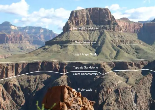
The Great Unconformity:
The Grand Canyon in the United States exhibits a significant gap in the rock record known as the Great Unconformity. It represents a period of erosion and missing rock layers spanning hundreds of millions of years, leaving geologists puzzled about the processes that led to such a gap.
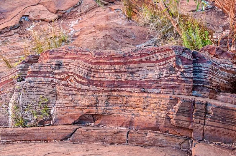
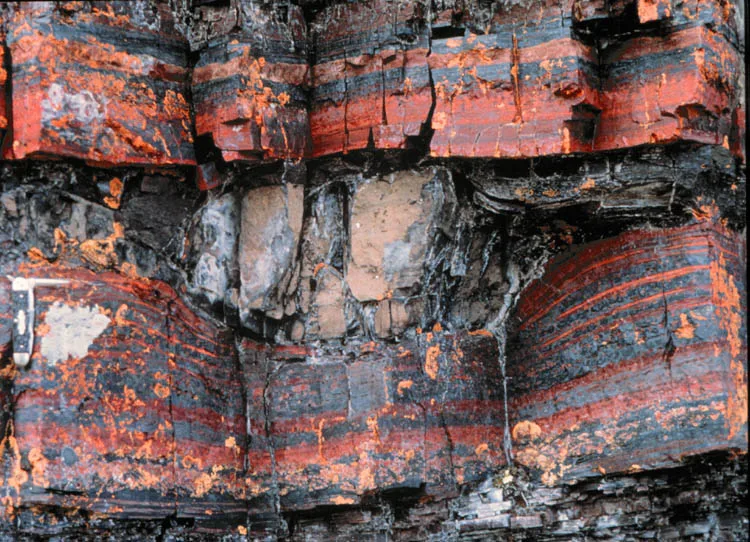
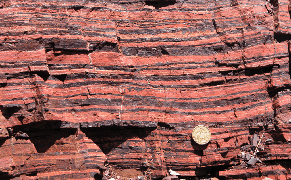
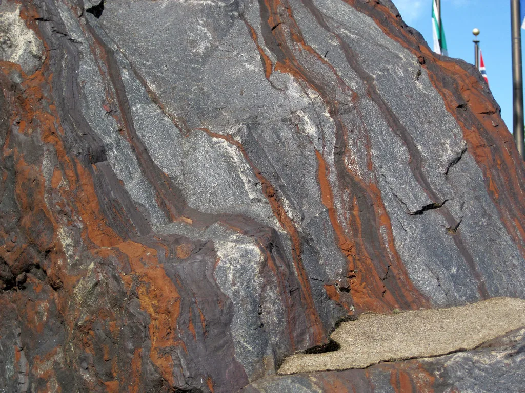
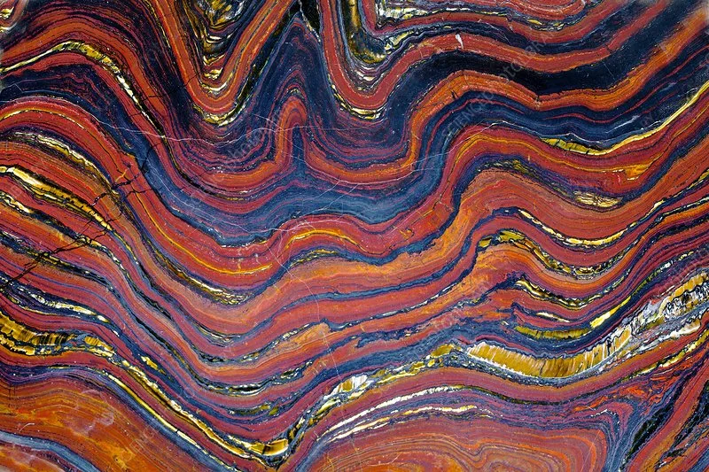
Banded Iron Formations (BIFs) are distinctive rock layers composed of alternating bands of iron-rich minerals and chert. These formations date back to the Precambrian era and are associated with the rise of atmospheric oxygen. The exact processes that led to their formation are not fully understood.
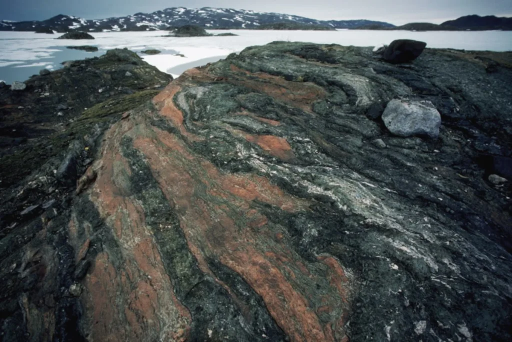
Greenland’s Ancient Mountains:
The mountains in Greenland, such as the Isua Greenstone Belt, are some of the oldest on Earth, dating back over 3 billion years. Understanding the geological processes that formed these ancient mountains and their significance in Earth’s history remains a challenge.
The Great Oxygenation Event:
Around 2.4 billion years ago, Earth experienced a significant increase in atmospheric oxygen known as the Great Oxygenation Event. The exact causes and consequences of this event, including its impact on early life forms, are still not fully understood.
The Cambrian Explosion:
The Cambrian Explosion, around 541 million years ago, marked a rapid diversification of life forms. The factors driving this sudden burst of biodiversity, including geological influences, are a subject of ongoing research and debate.
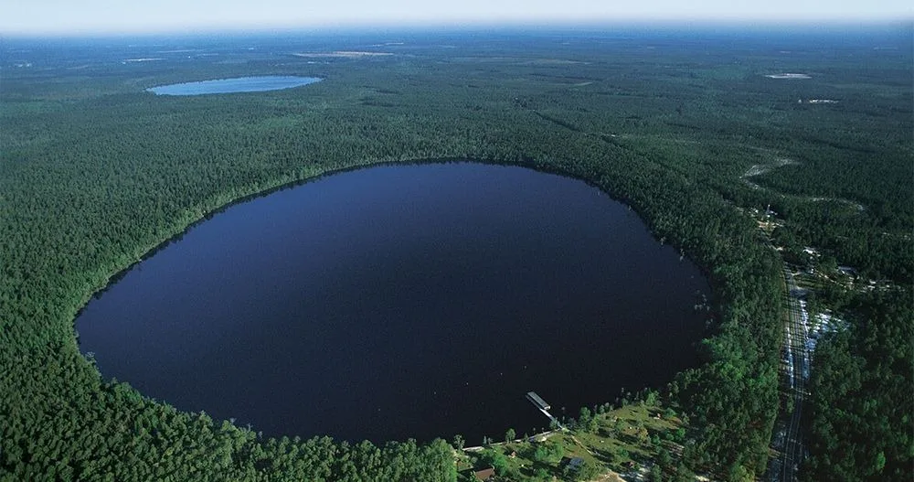
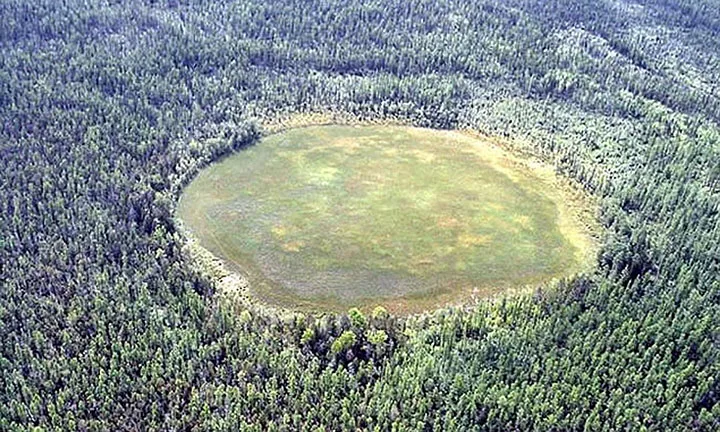
The Carolina Bays:
The Carolina Bays are elliptical depressions scattered across the Atlantic Coastal Plain of the United States. The origin of these features, whether caused by impacts, wind, or other geological processes, remains uncertain.
The Permian-Triassic Extinction:
The Permian-Triassic Extinction, also known as the Great Dying, occurred about 252 million years ago and is the most severe mass extinction event in Earth’s history. The geological processes and triggers leading to such a catastrophic event are still not fully understood.
The Tunguska Event:
The site of the Tunguska event as it’s seen now
In 1908, a massive explosion occurred over Tunguska, Siberia, flattening an estimated 80 million trees. While widely believed to be caused by the airburst of a meteoroid or comet, the exact nature of the object and the details of the event’s geological aftermath are not entirely clear.
The Piri Reis Map:
The Piri Reis Map, created by an Ottoman admiral in the early 16th century, shows a surprisingly accurate representation of the coastline of Antarctica. This has led to speculation about ancient civilizations and their geological knowledge, as the accuracy of the map seems inconsistent with the historical understanding of the time.
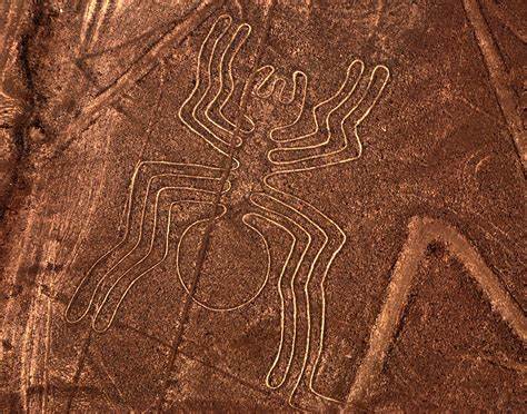
The Nazca Lines:
The Nazca Lines in Peru are ancient geoglyphs created by removing the reddish-brown iron oxide-coated pebbles to reveal the light-colored earth underneath. The purpose and methods behind the creation of these large-scale designs, visible only from the air, remain a subject of speculation and mystery.
In conclusion, the ancient geological mysteries that have shaped our planet are testament to the complexity and dynamism of Earth’s history. As we peer into the distant past, we encounter gaps in the rock record, enigmatic formations, and cataclysmic events that challenge our understanding of geological processes. These mysteries not only invite scientific inquiry but also spark the imagination, prompting us to contemplate the profound forces that have sculpted the Earth over eons.
From the Great Unconformity to the Permian-Triassic Extinction, each mystery carries its own unique story, leaving researchers with puzzles that continue to be pieced together. The pursuit of answers to these mysteries not only enhances our understanding of Earth’s geological evolution but also sheds light on the interconnectedness of geological, biological, and climatic events throughout history.
As scientific techniques and technologies advance, new discoveries may provide insights into these ancient enigmas, unlocking the secrets held within the Earth’s geological archives. The exploration of these mysteries not only deepens our scientific knowledge but also underscores the importance of preserving and understanding our planet’s past to navigate its future. The journey through these geological mysteries is an ongoing adventure, offering a glimpse into the fascinating narrative of Earth’s geological history.
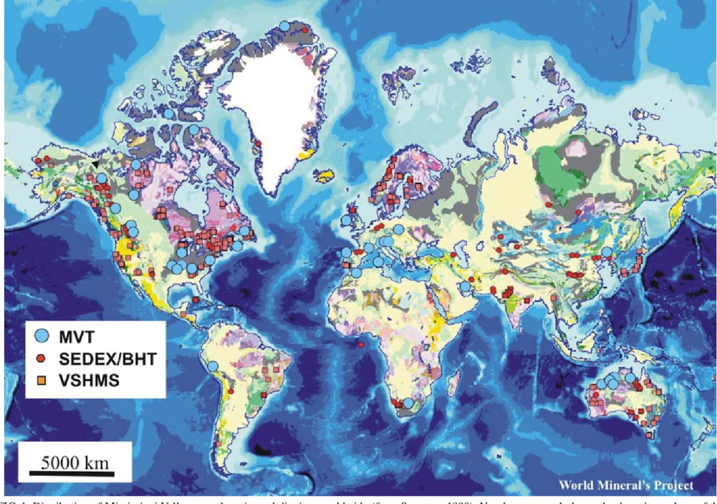
Gravity surveys are geophysical techniques used to measure the variations in the Earth’s gravitational field at different locations. These surveys involve the measurement of the gravitational acceleration at the Earth’s surface, typically expressed in terms of milligals (mGal) or microgals (μGal). The purpose of gravity surveys is to map and understand the distribution of subsurface density variations, which can provide valuable information about the geological structure and composition of the Earth’s interior.
Gravity surveys are based on the fundamental principle that variations in subsurface density cause corresponding variations in the local gravitational field. High-density materials, such as rocks and minerals, exert a stronger gravitational pull than low-density materials like water or air. By measuring these gravitational variations, scientists can infer the distribution of different rock types and geological structures beneath the Earth’s surface.
Historical Overview: Gravity surveys have a long history in geophysics, dating back to the 17th century when Sir Isaac Newton first formulated the law of universal gravitation. However, it wasn’t until the 20th century that precise gravity measurements became practical with the development of accurate instruments.
In the early 20th century, gravity surveys started to play a crucial role in oil and mineral exploration. Gravity measurements became a standard tool for identifying subsurface structures and locating potential resources. The advent of more sophisticated instrumentation, including gravimeters and satellite-based gravity measurements, has further enhanced the precision and scope of gravity surveys in modern geophysics.
Importance in Geophysics: Gravity surveys are fundamental to the field of geophysics, providing critical information about the Earth’s subsurface. Some key aspects of their importance include:
Resource Exploration: Gravity surveys are widely used in the exploration for natural resources such as oil, gas, and minerals. Variations in subsurface density can indicate the presence of geological structures associated with these valuable resources.
Understanding Geological Structures: Gravity data helps geophysicists map and understand the distribution of subsurface geological structures such as faults, folds, and basins. This information is vital for geological studies and natural hazard assessments.
Crustal Studies: Gravity surveys contribute to our understanding of the Earth’s crustal structure. They help identify variations in crustal thickness, composition, and tectonic processes, providing insights into the Earth’s dynamic evolution.
Environmental and Engineering Applications: Gravity surveys are used in environmental studies to assess groundwater resources and monitor changes in subsurface water storage. In engineering, they aid in the evaluation of subsurface conditions for construction projects.
Satellite-Based Gravity Measurements: Advances in satellite technology have enabled the collection of gravity data on a global scale. Satellite gravity measurements contribute to studies of Earth’s overall mass distribution, sea level changes, and large-scale geological processes.
In summary, gravity surveys are a versatile and essential tool in geophysics, providing valuable information for a wide range of applications, from resource exploration to understanding the Earth’s structure and dynamics.
Basic Principles of Gravity
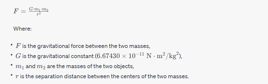
Newton’s Law of Gravitation: Newton’s law of gravitation, formulated by Sir Isaac Newton in 1687, is a fundamental principle that describes the gravitational attraction between two objects with mass. The law is expressed mathematically as:
This law states that every point mass attracts every other point mass in the universe with a force that is directly proportional to the product of their masses and inversely proportional to the square of the distance between their centers.
Gravity as a Force: Gravity is considered a force of attraction between objects with mass. According to Newton’s law of gravitation, every object in the universe attracts every other object with a force. The force of gravity is responsible for phenomena such as the falling of objects, the orbits of planets around the sun, and the tides on Earth.
Gravity is a universal force, acting on all objects with mass, and it is always attractive. The strength of the gravitational force depends on the masses of the objects involved and the distance between them. Larger masses and shorter distances result in stronger gravitational forces.
Gravitational Acceleration: Gravitational acceleration, often denoted as g, is the acceleration experienced by an object due to the gravitational pull of a massive body, such as the Earth. Near the Earth’s surface, the gravitational acceleration is approximately 9.8 m/s29.8 m/s2 and is directed towards the center of the Earth.
This formula implies that all objects, regardless of their mass, experience the same gravitational acceleration near the Earth’s surface. It is important to note that gravitational acceleration decreases with altitude above the Earth’s surface and increases with depth below the surface, as it depends on the distance from the center of the Earth.
In summary, Newton’s law of gravitation describes the force of attraction between masses, gravity is considered a force, and gravitational acceleration represents the acceleration experienced by an object due to gravity. These principles form the basis for understanding and calculating gravitational interactions in various contexts.
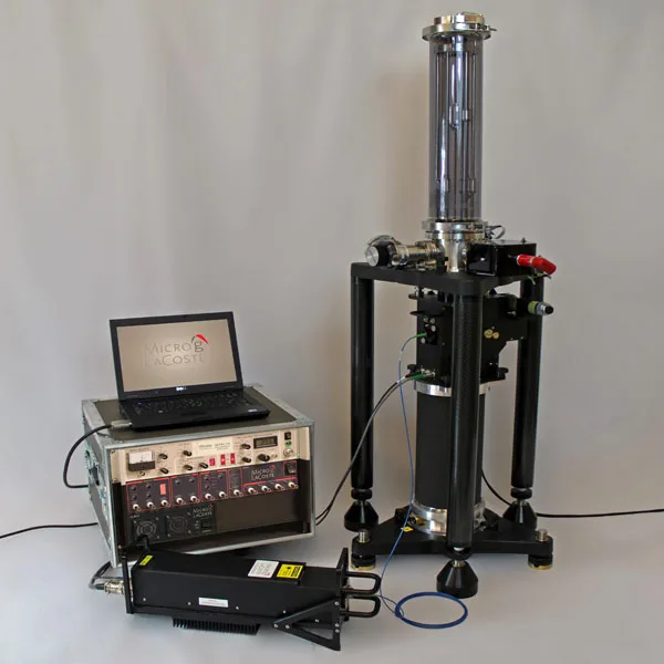
Instrumentation
Gravimeters: Gravimeters are instruments designed to measure the local gravitational acceleration at a specific location. These instruments are crucial in gravity surveys and various geophysical applications. Gravimeters operate on the principle that the force of gravity acting on a test mass can be measured to determine the local gravitational field strength. There are several types of gravimeters, each with its own design and sensitivity.
Types of Gravimeters:
Spring Gravimeters:
Principle: Spring gravimeters operate based on Hooke’s law, where the displacement of a spring is proportional to the force applied to it. The test mass is attached to a spring, and the gravitational force causes the spring to stretch or compress.
Operation: As the test mass moves, the displacement of the spring is measured and used to calculate the gravitational acceleration.
Accuracy: Spring gravimeters are generally less accurate than more modern types but are still suitable for many gravity survey applications.
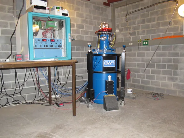
Superconducting Gravimeters:
Principle: Superconducting gravimeters use the principle of electromagnetic levitation. A superconducting sphere is levitated using magnetic fields, and any change in its position is a measure of the gravitational force.
Operation: Changes in the position of the superconducting sphere are detected and converted into a measure of gravitational acceleration.
Accuracy: Superconducting gravimeters are among the most accurate and sensitive gravimeters, making them suitable for high-precision gravity measurements.
Atomic Gravimeters:
Principle: Atomic gravimeters use the interference of matter waves to measure gravitational acceleration. Atoms are manipulated using lasers and other techniques to create an interferometer, and the interference pattern is used to determine gravitational acceleration.
Operation: The interference pattern is affected by the local gravitational field, allowing for highly precise measurements.
Accuracy: Atomic gravimeters are also capable of high precision and are used in specialized applications.
Measurement Units:
The measurement of gravity is typically expressed in units of acceleration. Commonly used units include:
Gal (Galileo):
Named after Galileo Galilei, this is the basic unit of acceleration due to gravity. 1 Gal is equal to 1 centimeter per second squared (cm/s²). In practice, gravity values are often expressed in milligals (mGal), where 1 mGal is equal to 0.001 Gal.
Microgal (μGal):
Often used for very precise measurements, especially in gravity surveys or when studying subtle gravitational variations. 1 μGal is equal to 0.000001 Gal.
These units are used to quantify the strength of the gravitational field at a particular location and are essential for interpreting gravity survey data. In gravity surveys, variations in gravitational acceleration are measured in milligals or microgals to detect subtle changes in subsurface density and geological structures.
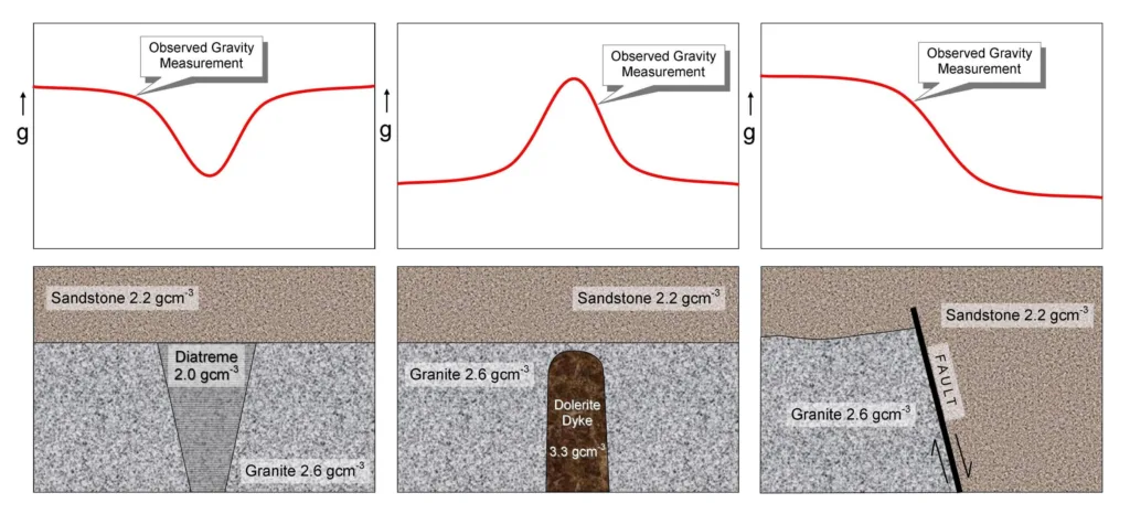
Gravity Anomalies
Definition and Types:
Gravity anomalies refer to deviations from the expected or normal gravitational field at a particular location on the Earth’s surface. These anomalies can be caused by variations in subsurface density, topography, and geological structures. Gravity anomalies are crucial in geophysics and are often measured during gravity surveys to provide insights into the underlying geological features.
Types of Gravity Anomalies:
Free-air Anomaly:
Definition: The free-air anomaly represents the difference between the observed gravitational acceleration at a specific location and the theoretical gravitational acceleration at that location due to the Earth’s shape and rotation. It is the simplest form of gravity anomaly and is calculated without correcting for the influence of topography and local mass variations.
Causes: Free-air anomalies are influenced by variations in subsurface density and topography.
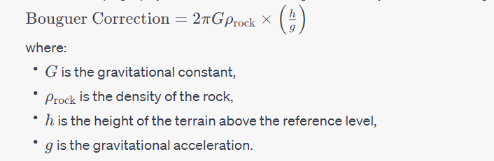
Bouguer Anomaly:
Definition: The Bouguer anomaly is a gravity anomaly that takes into account the effects of topography on gravity. It is calculated by removing the gravitational effect of surface topography and considering only the gravitational attraction of subsurface masses. This correction helps to isolate the contribution of subsurface density variations.
Correction: The Bouguer correction involves subtracting the gravitational attraction of the elevated terrain from the observed gravity value. This correction is typically applied using the Bouguer formula: Bouguer Anomaly=Observed Gravity−Bouguer CorrectionBouguer Anomaly=Observed Gravity−Bouguer Correction
Applications: Bouguer anomalies are valuable for geological studies as they provide information about subsurface density variations, helping to identify features such as basins, faults, and ore bodies.
Isostatic Anomaly:
Definition: The isostatic anomaly accounts for variations in the Earth’s crustal thickness and isostatic equilibrium. Isostatic equilibrium refers to the balance between the uplift and subsidence of the Earth’s crust to achieve gravitational and buoyant equilibrium. Isostatic anomalies help in understanding the compensation mechanisms of the Earth’s lithosphere.
Causes: Isostatic anomalies arise due to variations in crustal thickness and density. For example, regions with thicker crust may exhibit positive isostatic anomalies, while regions with thinner crust may show negative isostatic anomalies.
Applications: Isostatic anomalies are essential in tectonic studies and understanding the geological history of a region. They provide insights into crustal processes and the effects of past tectonic events.
In summary, gravity anomalies are variations in the Earth’s gravitational field, and three common types include free-air anomalies, Bouguer anomalies, and isostatic anomalies. Each type provides distinct information about subsurface density, topography, and lithospheric processes, making them valuable tools in geological and geophysical investigations.
Gravity Data Acquisition
Acquiring gravity data involves conducting gravity surveys in the field. The accuracy and reliability of the acquired data depend on careful planning, proper instrumentation, and adherence to established survey design principles. Here are the key aspects of gravity data acquisition:
Field Procedures:
Instrument Calibration:
Before starting the survey, gravimeters must be calibrated to ensure accurate measurements. Calibration involves checking and adjusting the instrument’s response to gravity.
Benchmark Establishment:
Establishing benchmarks at known elevations is crucial for accurate gravity measurements. These benchmarks serve as reference points for both gravity and elevation data.
Station Setup:
Gravity measurements are typically taken at designated survey stations. Careful attention must be paid to the station setup to ensure stability and minimize external disturbances. Stations should be chosen to cover the survey area adequately.
Data Collection:
Gravimeters are positioned at each survey station, and measurements are taken. Readings are recorded at each station, and the process is repeated across the survey area.
Elevation Data:
Along with gravity data, elevation data is often collected at each station. This elevation information is essential for correcting gravity anomalies, especially when calculating Bouguer anomalies.
Navigation and GPS:
Accurate navigation and GPS systems are used to precisely locate each survey station. This information is crucial for georeferencing the acquired gravity data.
Quality Control:
Regular quality control checks are conducted during the survey to identify and correct any issues promptly. This includes checking instrument drift, ensuring proper leveling, and validating GPS positions.
Data Collection Techniques:
Point Gravity Surveys:
In point gravity surveys, measurements are taken at individual stations spaced across the survey area. This method is suitable for smaller, more detailed surveys.
Profile Gravity Surveys:
Profile gravity surveys involve taking measurements along predetermined lines or profiles. This method provides a cross-sectional view of gravity variations and is suitable for linear features or geological transects.
Grid Gravity Surveys:
In grid gravity surveys, measurements are taken at regularly spaced intervals to cover the entire survey area systematically. This method is suitable for regional mapping and identifying large-scale geological features.
Airborne Gravity Surveys:
Airborne gravity surveys involve mounting gravimeters on aircraft. This technique allows for rapid data acquisition over large and inaccessible areas. It is often used in mineral exploration and regional mapping.
Survey Design:
Density Contrasts:
Survey design should consider the expected density variations in the subsurface. Areas with significant density contrasts are of particular interest.
Spacing of Stations:
The spacing between survey stations depends on the objectives of the survey. Closer spacing is needed for detailed investigations, while larger spacing may be sufficient for regional mapping.
Topography:
Survey design should account for the influence of topography on gravity measurements. Bouguer corrections are applied to account for the gravitational effects of surface topography.
Survey Area Extent:
The extent of the survey area should be carefully determined based on the geological and geophysical objectives. It may involve considering regional geological structures, potential resource locations, or specific research questions.
Flight Paths (for airborne surveys):
In airborne gravity surveys, the design includes planning optimal flight paths to cover the entire survey area efficiently. Flight altitude and speed are critical parameters.
Careful consideration of these factors during survey design and execution is essential for obtaining reliable gravity data that can provide meaningful insights into subsurface geological structures and density variations.
Data Processing and Corrections in Gravity Surveys
After collecting raw gravity data in the field, several corrections are applied to account for various factors that can influence the measurements. The goal is to obtain gravity anomalies that reflect subsurface variations rather than external influences. Here are some common corrections:
Terrain Corrections:
Purpose: Corrects for the gravitational effect of topography, as the elevation of the measurement point influences the observed gravity.
Method: Calculated using digital terrain models (DTMs) to estimate the gravitational attraction of the topography. The formula for terrain correction is given by:
Bouguer Corrections:
Purpose: Corrects for the gravitational effects of masses between the measurement point and infinity, primarily the mass of the Earth’s crust.
Method: The Bouguer correction is applied to the observed gravity to remove the effect of surface topography and calculate the Bouguer anomaly. The formula is given by:
Latitude Corrections:
Purpose: Corrects for the centrifugal force caused by the Earth’s rotation, which varies with latitude.
Method: The correction is based on the formula:
Eötvös Corrections:
Purpose: Corrects for the gravitational effect due to the Earth’s rotation and the non-spherical shape of the Earth.
Method: The Eötvös correction is given by:
These corrections are essential to isolate the subsurface density variations and obtain accurate gravity anomalies, which are then used for geological and geophysical interpretations. The choice of corrections depends on the specific characteristics of the survey area and the objectives of the study.
Interpretation of Gravity Data
Interpretation of gravity data involves analyzing gravity anomalies to extract information about the subsurface geological features and density variations. This process is crucial for understanding the Earth’s structure, identifying potential mineral or hydrocarbon resources, and mapping tectonic and structural elements. Here’s a general guide on interpreting gravity data:
Identifying Anomalies:
Gravity anomalies are deviations from the expected gravitational field at a specific location. Positive anomalies often indicate higher than average subsurface density, while negative anomalies suggest lower density.
Correlation with Geological Features:
Correlate gravity anomalies with known geological features in the region. Certain geological structures, such as faults, basins, and mountain ranges, can be associated with distinct gravity anomalies.
Regional vs. Local Anomalies:
Distinguish between regional and local anomalies. Regional anomalies cover large areas and may be associated with deep-seated geological structures, while local anomalies are often linked to shallower features.
Bouguer Anomalies:
Analyze Bouguer anomalies, which have been corrected for the effects of topography. Bouguer anomalies provide a clearer picture of subsurface density variations by removing the gravitational effects of surface features.
Isostatic Anomalies:
Consider isostatic anomalies, especially in areas with significant variations in crustal thickness. Positive isostatic anomalies may indicate regions of uplift or thickened crust, while negative anomalies can suggest subsidence or thinner crust.
Gradient Analysis:
Examine gradients in gravity data to identify boundaries between geological units. Steep gradients may indicate fault zones or other abrupt changes in subsurface composition.
Integration with Other Data:
Integrate gravity data with other geophysical data, such as seismic surveys or magnetic data, for a more comprehensive understanding of subsurface structures.
Depth Estimation:
Attempt to estimate the depth to the source of gravity anomalies. Different mathematical and modeling techniques can be applied to infer the depth of density contrasts contributing to the anomalies.
Hydrocarbon Exploration:
In the context of hydrocarbon exploration, gravity data can be used to identify potential sedimentary basins, salt domes, or other structural traps that may contain oil and gas deposits.
Mineral Exploration:
Gravity surveys are valuable in mineral exploration. Certain minerals, like dense metallic ores, can create distinctive gravity anomalies. Anomalies may indicate the presence of mineral deposits.
Modeling and Inversion:
Advanced interpretation may involve numerical modeling and inversion techniques to create subsurface models that best fit the observed gravity data. These methods help refine the understanding of geological structures.
Scientific Research:
Gravity data interpretation is also essential for scientific research, contributing to our understanding of Earth’s dynamics, tectonic processes, and the composition of the crust and mantle.
Interpreting gravity data requires a combination of geological knowledge, expertise in geophysics, and an understanding of the regional tectonic and geological context. Collaborative efforts between geophysicists, geologists, and other experts enhance the accuracy and reliability of the interpretations.
Applications of Gravity Surveys
Gravity surveys have a wide range of applications across various scientific, industrial, and environmental fields. Here are some key applications:
Mineral Exploration:
Gravity surveys are crucial in mineral exploration for identifying subsurface structures associated with mineral deposits. Density variations related to ore bodies, faults, and geological structures can be detected through gravity anomalies.
Oil and Gas Exploration:
In the exploration for oil and gas, gravity surveys help identify sedimentary basins, salt domes, and other geological structures that may contain hydrocarbon reservoirs. Gravity data, when integrated with other geophysical methods, assists in mapping potential exploration targets.
Groundwater Exploration:
Gravity surveys can be used to locate and assess groundwater resources. Variations in subsurface density related to aquifers and groundwater distribution can be detected, aiding in groundwater resource management.
Geological Mapping:
Gravity surveys contribute to geological mapping by revealing subsurface structures, fault lines, and variations in crustal thickness. This information is valuable for understanding the geological history and evolution of a region.
Environmental Studies:
Gravity surveys are used in environmental studies to investigate subsurface structures related to natural hazards such as landslides, earthquakes, and volcanic activity. Understanding subsurface geology is essential for assessing potential risks.
Civil Engineering:
In civil engineering projects, gravity surveys help assess the stability of the ground and identify potential challenges related to subsurface conditions. This information is critical for infrastructure projects such as dams, bridges, and tunnels.
Archaeological Investigations:
Gravity surveys can be applied in archaeological studies to detect buried structures or anomalies indicative of archaeological features. This non-invasive method aids in site assessments and cultural heritage preservation.
Tectonic Studies:
Gravity surveys contribute to tectonic studies by providing information about the Earth’s crustal structure, subsurface composition, and tectonic processes. They help researchers understand the dynamics of tectonic plates and the forces shaping the Earth’s crust.
Isostatic Studies:
Gravity surveys are employed in isostatic studies to analyze variations in crustal thickness and isostatic equilibrium. This information contributes to understanding the compensating adjustments in the Earth’s lithosphere.
Space Exploration:
Gravity data is crucial for space missions and planetary exploration. Understanding gravitational anomalies on other celestial bodies provides insights into their internal structure and geological features.
Climate and Environmental Change:
Gravity data can be used to monitor changes in water storage, such as variations in ice mass or groundwater levels. This information contributes to studies on climate change and its impacts on Earth’s systems.
Global Geoid Modeling:
Gravity data is used to model the geoid, which represents the Earth’s equipotential surface of gravitational potential energy. Accurate geoid models are essential for precise measurements and mapping on the Earth’s surface.
In summary, gravity surveys play a versatile and essential role in various scientific and applied fields, contributing to our understanding of the Earth’s structure, resources, and environmental conditions. The information obtained from gravity surveys is valuable for making informed decisions in resource exploration, environmental management, and scientific research.
Case Studies
While I can’t provide real-time or the latest case studies, I can offer examples of historical or generic case studies to illustrate how gravity surveys have been applied in different scenarios.
Mineral Exploration in Canada:
Objective: Identify potential mineral deposits in a remote region of Canada.
Method: Airborne gravity surveys were conducted over the target area. Gravity anomalies were analyzed to identify subsurface structures associated with mineralization.
Results: The survey successfully located anomalies indicative of dense rock formations. Follow-up ground-based exploration confirmed the presence of valuable mineral deposits, leading to a significant mining operation.
Oil and Gas Exploration in the Gulf of Mexico:
Objective: Locate potential hydrocarbon reservoirs beneath the seafloor in the Gulf of Mexico.
Method: Marine gravity surveys were conducted using ships equipped with gravimeters. Gravity data, along with seismic data, helped map subsurface structures related to potential oil and gas reserves.
Results: The surveys identified promising areas with significant gravity anomalies, leading to successful drilling operations and the discovery of new oil and gas fields.
Geothermal Resource Assessment in Iceland:
Objective: Assess the geothermal potential in a volcanic region in Iceland for sustainable energy development.
Method: Gravity surveys were combined with other geophysical methods to map subsurface structures, including magma chambers and heat reservoirs. The aim was to identify areas with high geothermal potential.
Results: The gravity surveys played a crucial role in identifying subsurface features associated with geothermal activity. This information guided the development of geothermal power plants, contributing to Iceland’s use of renewable energy.
Environmental Hazard Assessment in California:
Objective: Assess the risk of landslides in a hilly region prone to geological hazards in California.
Method: Gravity surveys were conducted to map subsurface structures and identify potential landslide-prone areas. The goal was to provide early warning and inform land-use planning.
Results: The gravity surveys revealed areas with anomalous subsurface density, indicating potential instability. This information was used for risk assessment and implementing preventive measures, reducing the risk of landslides.
Archaeological Site Investigation in Egypt:
Objective: Explore the subsurface near an archaeological site in Egypt for buried structures.
Method: Ground-based gravity surveys were conducted to detect density anomalies associated with potential archaeological features.
Results: The gravity surveys identified anomalies indicative of buried structures, leading to targeted excavations. Archaeological discoveries were made, shedding light on the historical significance of the site.
These case studies demonstrate the versatility of gravity surveys in diverse applications, from resource exploration and environmental assessment to archaeological investigations. The integration of gravity data with other geophysical methods enhances the understanding of subsurface structures and contributes to informed decision-making in various fields.
Advancements in Gravity Survey Technology
Advancements in gravity survey technology have occurred over the years, leading to improvements in data accuracy, acquisition efficiency, and the ability to conduct surveys in challenging environments. Here are some key advancements:
Improved Gravimeter Technology:
Superconducting Gravimeters: These gravimeters use superconducting materials to achieve extremely high sensitivity, allowing for the detection of even subtle changes in gravity. Superconducting gravimeters are highly accurate and are used in applications requiring precision, such as crustal deformation studies.
Quantum Gravimeters: Emerging quantum technologies, including atom interferometry and atom cloud expansion, are being applied to gravimetry. Quantum gravimeters have the potential to provide unprecedented sensitivity and precision, surpassing traditional instruments.
Airborne Gravity Gradiometry:
Airborne Gravity Gradiometers (AGG): Gravity gradiometry involves measuring the spatial gradient of gravity. AGGs, mounted on aircraft, can collect data over large areas rapidly. This technology is especially valuable in regional surveys and mineral exploration, where quick and high-density data acquisition is essential.
Satellite-Based Gravity Measurements:
Gravity Recovery and Climate Experiment (GRACE): GRACE was a satellite mission designed to measure variations in Earth’s gravity field over time. It provided valuable insights into mass redistribution, including changes in ice mass, water storage, and tectonic processes.
GRACE Follow-On (GRACE-FO): A successor to the GRACE mission, GRACE-FO continues the monitoring of Earth’s gravity field using twin satellites. It contributes to climate studies, hydrology, and understanding large-scale mass movements.
Innovations in Data Processing and Inversion:
Advanced Inversion Techniques: Improved inversion algorithms and computational methods allow for more accurate interpretation of gravity data. Inversion techniques help create detailed subsurface models by considering multiple geophysical datasets simultaneously.
Machine Learning and Artificial Intelligence: These technologies are increasingly being applied to process and interpret gravity data. Machine learning algorithms can assist in pattern recognition, noise reduction, and the identification of geological features.
Integrated Geophysical Surveys:
Multisensor Integration: Combining gravity surveys with other geophysical methods, such as magnetic surveys, seismic studies, and electromagnetic surveys, provides a more comprehensive understanding of subsurface structures. Integrated surveys enhance the accuracy of geological interpretations.
Miniaturization and Portability:
Miniaturized Gravimeters: Advances in sensor technology have led to the development of smaller and more portable gravimeters. These instruments are suitable for a wide range of applications, including field surveys in challenging terrains.
Real-Time Data Transmission:
Wireless and Satellite Communication: Gravimeters equipped with real-time data transmission capabilities allow for immediate data access and analysis. This is particularly useful for survey planning, quality control, and decision-making in the field.
High-Resolution Global Gravity Models:
GOCE (Gravity field and steady-state Ocean Circulation Explorer): GOCE was a European Space Agency (ESA) satellite mission dedicated to measuring Earth’s gravity field with unprecedented accuracy. It contributed to the creation of high-resolution global gravity models.
These advancements collectively contribute to more efficient, accurate, and versatile gravity surveys, expanding their applications in scientific research, resource exploration, environmental studies, and various other fields. Ongoing research and technological developments continue to push the boundaries of gravity survey capabilities.
Conclusion: Summary of Key Points
Summary of Key Points:
Gravity Surveys Definition:
Gravity surveys involve measuring variations in the Earth’s gravitational field to understand subsurface density variations and geological structures.
Basic Principles:
Newton’s Law of Gravitation governs the gravitational force between masses, with gravity expressed as a force and gravitational acceleration representing the acceleration due to gravity.
Instrumentation:
Gravimeters, such as spring gravimeters, superconducting gravimeters, and atomic gravimeters, are used to measure gravity. Measurement units include the Gal, milligal, and microgal.
Gravity Anomalies:
Anomalies result from deviations in the expected gravitational field. Types include free-air, Bouguer, and isostatic anomalies.
Data Acquisition:
Field procedures involve calibration, benchmark establishment, station setup, data collection, elevation data, navigation, and quality control. Data collection techniques include point, profile, and grid surveys, as well as airborne surveys.
Corrections:
Terrain, Bouguer, latitude, and Eötvös corrections are applied to account for topography, subsurface density, latitude, and the Earth’s rotation.
Interpretation:
Gravity data interpretation involves identifying anomalies, correlating with geological features, distinguishing regional and local anomalies, and integrating with other geophysical data. It aids in depth estimation, mineral and oil exploration, environmental studies, and archaeological investigations.
Applications:
Gravity surveys find applications in mineral and oil exploration, groundwater assessment, geological mapping, environmental studies, civil engineering, archaeology, tectonic studies, and space exploration.
Advancements in Technology:
Advancements include improved gravimeter technology, airborne gravity gradiometry, satellite-based gravity measurements, innovations in data processing, machine learning, and miniaturization. These enhance data accuracy, acquisition efficiency, and survey capabilities.
Importance of Gravity Surveys in Geophysics:
Gravity surveys are crucial in geophysics for several reasons:
Mapping Subsurface Structures:
Gravity surveys help map subsurface structures, providing insights into geological features, fault lines, and variations in crustal thickness.
Resource Exploration:
In mineral, oil, and gas exploration, gravity surveys identify anomalies indicative of potential resource deposits, aiding in efficient exploration.
Environmental Studies:
Gravity data contribute to environmental studies by assessing subsurface conditions related to landslides, earthquakes, and groundwater resources.
Geological Understanding:
Gravity surveys enhance our understanding of the Earth’s geological history, tectonic processes, and crustal composition.
Engineering Applications:
In civil engineering, gravity surveys assist in assessing ground stability, influencing infrastructure projects such as dams, bridges, and tunnels.
Scientific Research:
Gravity data contribute to scientific research, climate studies, and space exploration, providing valuable information about Earth’s dynamics and gravitational field.
In conclusion, gravity surveys are versatile and essential tools in geophysics, playing a critical role in diverse applications that contribute to our understanding of the Earth and its resources. Ongoing technological advancements continue to expand the capabilities and impact of gravity surveys in various scientific and applied fields.
Mississippi Valley-Type (MVT) deposits are a specific type of mineral deposit characterized by the occurrence of lead and zinc ores. These deposits are named after the Mississippi Valley region in the United States, where they were first recognized and extensively studied. MVT deposits are part of the broader category of sedimentary exhalative (SEDEX) deposits, which form through the deposition of minerals from hydrothermal fluids that originate in the Earth’s crust.
Definition of Mississippi Valley-Type (MVT) Deposits:
MVT deposits are typically composed of galena (lead sulfide) and sphalerite (zinc sulfide), along with varying amounts of other minerals such as fluorite, barite, and calcite. These deposits are sediment-hosted and are found in carbonate rocks, such as limestone and dolomite, where the ore minerals precipitate from metal-bearing fluids. MVT deposits often occur in faulted and fractured zones, and their formation is closely related to tectonic activity.
Historical Context and Discovery:
The discovery of MVT deposits dates back to the 19th century. The first MVT deposit recognized as such was the Old Mines deposit in Missouri, USA, which was discovered in the 1720s. However, it wasn’t until the late 19th and early 20th centuries that the geological community began to understand the distinctive characteristics of MVT deposits.
The term “Mississippi Valley-Type” was coined by the American geologist Erasmus Haworth in the early 20th century. The deposits gained significant attention in the 1920s and 1930s when economic exploitation of these ores became more widespread. Mining operations in the Mississippi Valley region, particularly in states like Missouri and Illinois, contributed significantly to the global production of lead and zinc during this period.
The understanding of MVT deposits has evolved over time, with ongoing research focusing on the geological processes that lead to their formation. The recognition of MVT deposits in other parts of the world, such as Ireland, Australia, and the Middle East, has expanded the significance of these deposits beyond the Mississippi Valley region. They are now recognized as an important source of lead and zinc on a global scale.
In summary, Mississippi Valley-Type deposits represent a specific class of sediment-hosted lead-zinc deposits that were first identified in the Mississippi Valley region in the United States. Their historical context is closely tied to the development of mining operations in this region, and ongoing research continues to enhance our understanding of their geological characteristics and formation processes.
Geological Setting
Mississippi Valley-Type (MVT) deposits are generally found in sedimentary environments and are associated with specific geological conditions. The key factors contributing to the formation of MVT deposits include the presence of suitable host rocks, specific fluid compositions, and favorable structural settings.
Types of Rocks and Formations Associated with MVT Deposits:
Carbonate Rocks: MVT deposits are commonly hosted in carbonate rocks, particularly limestone and dolomite. These rocks provide the necessary chemical environment for the precipitation of lead and zinc minerals from hydrothermal fluids.
Evaporites: The presence of evaporite deposits, such as gypsum and anhydrite, is often associated with MVT mineralization. Evaporites can act as seals, trapping the mineralizing fluids and creating localized environments conducive to ore deposition.
Clastic Sedimentary Rocks: MVT deposits may also occur in clastic sedimentary rocks, especially in areas where these rocks are in proximity to carbonate sequences. The clastic rocks can act as hosts or controls for the mineralizing fluids.
Tectonic Settings and Structural Controls:
Extensional Tectonic Settings: MVT deposits are often associated with extensional tectonic settings. In these environments, faulting and fracturing create conduits for hydrothermal fluids to migrate from the Earth’s crust to the sedimentary basins, facilitating the deposition of ore minerals.
Faults and Fractures: Structural controls play a crucial role in the formation of MVT deposits. Faults and fractures provide pathways for hydrothermal fluids to move through the Earth’s crust and interact with the host rocks. The movement along these structures can create voids and open spaces where mineralization occurs.
Dolomitization: Dolomitization, the replacement of limestone by dolomite, is a common process associated with MVT deposits. This alteration can enhance the permeability of the rock, allowing for the movement of mineralizing fluids.
Karst Topography: MVT deposits may occur in karst terrain, where dissolution of carbonate rocks creates underground conduits and voids. These karst features can serve as pathways for hydrothermal fluids and contribute to the concentration of ore minerals.
Understanding the geological setting of MVT deposits involves considering the interplay of various factors such as rock types, fluid compositions, and tectonic and structural controls. Ongoing research continues to refine our understanding of the geological conditions that contribute to the formation of these economically significant lead and zinc deposits.
Hydrothermal Processes Contributing to MVT Deposit Formation
MVT deposits form through hydrothermal processes, where mineral-rich fluids migrate through the Earth’s crust and interact with specific geological environments. The key steps in the formation of MVT deposits include:
Source of Metals: Metals such as lead and zinc are derived from deep-seated sources within the Earth’s crust. These metals are mobilized into hydrothermal fluids through various geological processes.
Fluid Migration: Hydrothermal fluids, enriched with metals, migrate through fractures and faults in the Earth’s crust. These fluids are typically brines, which are water solutions containing a high concentration of dissolved salts.
Interaction with Host Rocks: As the hydrothermal fluids move through the host rocks, they react with minerals in the surrounding environment. In the case of MVT deposits, the host rocks are often carbonate rocks like limestone and dolomite. The interaction leads to the precipitation of ore minerals, including galena (lead sulfide) and sphalerite (zinc sulfide).
Temperature and Pressure Changes: Changes in temperature and pressure along the fluid migration pathway can trigger the deposition of minerals. As the fluids move towards the Earth’s surface, they encounter conditions where the solubility of certain minerals decreases, leading to their precipitation.
Role of Brines and Fluid Migration:
Brine Composition: The hydrothermal fluids associated with MVT deposits are typically brines, which are saline solutions. These brines play a crucial role in transporting metal ions from the source rocks to the deposition sites within the sedimentary basin.
Fluid Migration Pathways: Faults and fractures in the Earth’s crust provide conduits for the migration of hydrothermal fluids. The movement of these fluids is often influenced by tectonic activity, and they follow paths of least resistance, guided by geological structures.
Fluid-Rock Interaction: As brines migrate through the host rocks, they interact with minerals in the surrounding environment. The dissolution and reprecipitation of minerals along the fluid pathway contribute to the formation of ore deposits.
Evaporation and Mixing: Changes in the chemical composition of the hydrothermal fluids, such as through evaporation or mixing with other fluids, can trigger the precipitation of minerals. This is often observed in the association of MVT deposits with evaporite minerals.
Mineralization Mechanisms:
Replacement: The most common mineralization mechanism in MVT deposits is replacement. Hydrothermal fluids replace the original minerals in the host rocks with ore minerals like galena and sphalerite. This replacement process can occur through selective dissolution and reprecipitation.
Open Space Filling: In areas of increased permeability, such as along faults and fractures, open spaces are created. Hydrothermal fluids can fill these open spaces, forming vein-like deposits of ore minerals.
Karst-Related Processes: In some MVT deposits, especially those in carbonate rocks, karst-related processes may contribute to mineralization. Dissolution of carbonate minerals creates voids and conduits where ore minerals can accumulate.
Understanding the interplay of these hydrothermal processes, the role of brines, and the specific geological conditions is crucial for deciphering the formation mechanisms of MVT deposits. Ongoing research in economic geology continues to refine our understanding of these processes and enhance exploration strategies for these valuable mineral resources.
Mineralogy and Ore Minerals
Common Minerals Found in MVT Deposits:
Galena (Lead Sulfide – PbS): Galena is a primary ore mineral for lead and is commonly found in MVT deposits. It forms cubic or octahedral crystals and has a metallic luster.
Sphalerite (Zinc Sulfide – ZnS): Sphalerite is the primary ore mineral for zinc in MVT deposits. It often occurs alongside galena and can exhibit a range of colors, including yellow, brown, black, or red.
Fluorite (Calcium Fluoride – CaF2): Fluorite is a common gangue mineral in MVT deposits, and its presence is often associated with mineralization. It forms cubic crystals and can vary in color, including purple, green, blue, and yellow.
Barite (Barium Sulfate – BaSO4): Barite is another common gangue mineral in MVT deposits. It typically forms tabular crystals and is often found associated with lead and zinc ores.
Calcite (Calcium Carbonate – CaCO3): Calcite is a carbonate mineral that may be present in MVT deposits. It can occur as transparent to opaque crystals and is commonly associated with the host carbonate rocks.
Dolomite (Calcium Magnesium Carbonate – CaMg(CO3)2): Dolomite is often associated with MVT deposits, and its presence may indicate a favorable geological environment for mineralization.
Characteristics and Composition of Ore Minerals:
Galena (Lead Sulfide – PbS): Galena is a heavy, metallic mineral with a high lead content. It has a distinctive silvery-gray color and is relatively soft.
Sphalerite (Zinc Sulfide – ZnS): Sphalerite can exhibit various colors and may range from transparent to opaque. It is relatively hard and has a resinous to adamantine luster.
Fluorite (Calcium Fluoride – CaF2): Fluorite is known for its fluorescence under ultraviolet light. It has a vitreous luster and is relatively soft.
Barite (Barium Sulfate – BaSO4): Barite is a dense mineral with a high specific gravity. It is typically colorless or white but can also be found in shades of blue, green, or yellow.
Calcite (Calcium Carbonate – CaCO3): Calcite is transparent to translucent and often exhibits a rhombohedral crystal habit. It effervesces in dilute acid due to its carbonate composition.
Dolomite (Calcium Magnesium Carbonate – CaMg(CO3)2): Dolomite is similar in appearance to calcite but is distinguished by its characteristic rhombohedral cleavage and its effervescence only in hot or concentrated acid.
Variations in Mineralogy Based on Geological Conditions:
The mineralogy of MVT deposits can vary based on geological conditions such as the composition of the host rocks, fluid chemistry, and temperature. Some variations include:
Variations in Gangue Minerals: The presence and abundance of gangue minerals, such as fluorite and barite, can vary. These minerals are influenced by the composition of hydrothermal fluids and the local geological environment.
Evaporite Minerals: In some MVT deposits, the association with evaporite minerals like gypsum and anhydrite can vary, depending on the local hydrothermal conditions and the presence of evaporite sequences.
Trace Elements: MVT deposits may contain trace elements in addition to lead and zinc. The presence of elements like silver, copper, and cadmium can vary, impacting the economic value of the deposit.
Metamorphism and Alteration: The degree of metamorphism and alteration in the host rocks can influence the mineralogy of MVT deposits. For example, dolomitization may occur as a result of alteration processes.
Understanding these variations is essential for mineral exploration and exploitation, as they can provide insights into the geological history and conditions that led to the formation of specific MVT deposits. Detailed mineralogical studies contribute to refining models of ore genesis and improving exploration strategies.
Exploration Techniques for MVT Deposits
Exploring for Mississippi Valley-Type (MVT) deposits involves a combination of geophysical, geochemical, and remote sensing techniques. These methods help identify potential areas for further exploration and provide valuable information about the subsurface geology. Here are some commonly used exploration techniques:
Gravity Surveys: Gravity anomalies may indicate variations in rock density, helping identify structures and potential ore bodies associated with MVT deposits.
Magnetic Surveys: Magnetic surveys can detect magnetic anomalies associated with certain minerals, providing insights into the geological structures that may host MVT mineralization.
Electromagnetic (EM) Surveys: EM surveys can be useful in detecting conductive bodies, including sulfide minerals associated with MVT deposits. Time-domain and frequency-domain EM methods are commonly employed.
Seismic Surveys: Seismic methods can help image subsurface structures and identify fault zones and other geological features that may be conducive to MVT mineralization.
Geochemical Approaches:
Soil Sampling: Geochemical analysis of soil samples can help identify anomalies in metal concentrations, providing clues to the presence of underlying ore bodies.
Stream Sediment Sampling: Collecting sediment samples from streams can help identify anomalous metal concentrations and guide exploration efforts.
Rock Sampling: Sampling rocks in the exploration area and analyzing their geochemistry can help identify alterations associated with MVT mineralization.
Drilling and Core Analysis:Diamond drilling provides direct samples of the subsurface geology, allowing for detailed analysis of ore minerals, alteration zones, and the overall geological context.
Remote Sensing and Modern Technologies:
Satellite Imagery: Remote sensing using satellite imagery can be valuable in mapping surface geology, identifying alteration patterns, and delineating geological structures associated with MVT deposits.
LiDAR (Light Detection and Ranging): LiDAR technology provides high-resolution topographic data, aiding in the identification of subtle geological features and structural patterns.
GIS (Geographic Information System): GIS integrates various data layers, such as geological maps, geophysical surveys, and geochemical data, facilitating the analysis of spatial relationships and the identification of prospective areas.
Machine Learning and Data Analytics: Advanced analytical techniques, including machine learning algorithms, can be applied to large datasets to identify patterns and anomalies, helping prioritize exploration targets.
Drone Technology: Unmanned aerial vehicles (UAVs) equipped with various sensors can provide high-resolution imagery and data for detailed mapping and exploration in areas with limited accessibility.
3D Geological Modeling: Creating three-dimensional models of the subsurface geology using modern modeling software helps visualize the distribution of ore bodies and geological structures.
Successful exploration for MVT deposits often involves an integrated approach, combining the strengths of various techniques to generate a comprehensive understanding of the geological setting. Advances in technology and data analysis continue to enhance the efficiency and accuracy of mineral exploration processes.
Case Studies
Notable Examples of MVT Deposits Worldwide:
Tri-State Mining District, USA:
Tri-State Mining District, USA:
Location: Missouri, Kansas, and Oklahoma, USA.
Details: The Tri-State Mining District is one of the most famous MVT districts, historically significant for lead and zinc production. The region, especially Missouri, has numerous MVT deposits, including the Old Lead Belt and the Viburnum Trend.
Irish Midlands, Ireland:
Location: Midlands region of Ireland.
Details: The Irish Midlands host several MVT deposits, including the famous Navan deposit. The Navan deposit is one of the largest zinc-lead deposits in Europe and has been a significant source of base metals for several decades.
Pine Point, Canada:
Location: Northwest Territories, Canada.
Details: The Pine Point Mining Camp in Canada is known for its MVT deposits, primarily zinc-lead ores. The area has been the site of extensive exploration and mining activities, contributing to Canada’s base metal production.
Dolomitization-Related MVT Deposits, Australia:
Location: Various regions in Australia.
Details: Australia has several MVT deposits associated with dolomitization processes. Notable examples include deposits in the McArthur Basin in the Northern Territory and the Admiral Bay and Teena deposits in Western Australia.
Middle East:
Location: Various countries in the Middle East.
Details: MVT deposits are found in several Middle Eastern countries, including Saudi Arabia and Iran. These deposits contribute to the regional production of lead and zinc.
Geographical Distribution and Regional Variations:
The distribution of MVT deposits is not limited to specific continents or regions, but they tend to occur in sedimentary basins with suitable geological conditions. Some general observations include:
North America: The USA, particularly the Mississippi Valley region, has a well-documented history of MVT deposits. Canada also hosts MVT deposits, including those in the Prairie Provinces and Northwest Territories.
Europe: Ireland is notable for its MVT deposits, with the Navan deposit being a significant example. Other European countries, such as Poland and Spain, also have MVT occurrences.
Australia: MVT deposits are found in various regions across Australia, with a particular emphasis on dolomitization-related deposits.
Asia: Some MVT deposits have been identified in parts of Asia, including the Middle East. Iran and Saudi Arabia are among the countries with known MVT occurrences.
Africa: While MVT deposits are not as extensively documented in Africa, there are reports of occurrences in different countries, reflecting the potential for these deposits in diverse geological settings.
The distribution of MVT deposits is influenced by geological factors such as the presence of suitable host rocks, tectonic settings, and hydrothermal fluid sources. Exploration efforts in different regions continue to uncover new occurrences and contribute to our understanding of the global distribution of MVT deposits.
Economic Significance
Mississippi Valley-Type (MVT) deposits are economically significant for several reasons, and their exploitation has played a crucial role in the global production of lead and zinc. Here are key aspects of the economic significance of MVT deposits:
Lead and Zinc Production:
Primary Sources: MVT deposits are major sources of lead (from galena – lead sulfide) and zinc (from sphalerite – zinc sulfide). These metals are essential for various industrial applications, including batteries, construction materials, and galvanization.
Contribution to Global Metal Supply:
Historical Significance: Many MVT deposits have a long history of mining and have been integral to the global metal supply. Regions like the Mississippi Valley in the United States and the Irish Midlands have historically been significant contributors to lead and zinc production.
Economic Impact on Local and Regional Economies:
Job Creation: The mining and processing of MVT deposits contribute to job creation in local communities. This includes employment in mining operations, processing plants, and associated support industries.
Infrastructure Development:
Infrastructure Investments: The development and operation of MVT mining projects often necessitate significant infrastructure investments. This includes transportation networks, power supply, and other facilities, contributing to regional development.
Export and Revenue Generation:
Export of Metals: Lead and zinc extracted from MVT deposits are typically exported to meet global demand. This contributes to the generation of foreign exchange and government revenue.
Diversification of Economies:
Diversification in Resource-Dependent Regions: Regions with MVT deposits often experience economic diversification as mining activities contribute to a mix of economic sectors beyond traditional agriculture or other resource-dependent industries.
Technological Advancements and Innovation:
Technological Innovation: The exploration and extraction of metals from MVT deposits drive technological innovation in mining and processing techniques. This can lead to advancements that have broader applications in the mining industry.
Global Market Dynamics:
Supply and Demand Influences: MVT deposits, as significant sources of lead and zinc, contribute to global market dynamics for these metals. Fluctuations in supply from MVT deposits can impact market prices.
Environmental and Social Considerations:
Environmental Practices: Responsible mining practices in MVT deposit operations are increasingly important, with companies adopting environmentally sustainable practices to minimize the impact on ecosystems and communities.
Long-Term Resource Sustainability:
Exploration and Resource Planning: Continued exploration for MVT deposits and responsible resource management contribute to the long-term sustainability of lead and zinc resources, ensuring a stable supply for future generations.
In summary, MVT deposits are economically significant due to their role as major sources of lead and zinc, their historical contributions to metal production, and the broader economic impacts on local and regional economies. As with any mineral extraction activity, balancing economic benefits with environmental and social considerations is essential for sustainable development.
SEDEX, which stands for Sedimentary Exhalative, refers to a type of mineral deposit that is formed by the precipitation of ore minerals from hydrothermal fluids that are expelled into a water environment, typically in a marine sedimentary basin. These deposits are significant sources of lead, zinc, and silver, and they are found in geological settings where certain conditions favor their formation.
Definition and Characteristics:
Formation: SEDEX deposits are formed through the interaction of hydrothermal fluids with sediments on the ocean floor. These fluids, rich in metals, are expelled from the Earth’s crust and rise through the sedimentary layers, depositing minerals as they cool.
Minerals: The primary ore minerals found in SEDEX deposits include galena (lead sulfide), sphalerite (zinc sulfide), and various sulfosalts. Silver often occurs as a byproduct.
Host Rocks: SEDEX deposits are commonly hosted in shale and other fine-grained sedimentary rocks. The ore minerals are often disseminated throughout the host rock.
Stratigraphy: The formation of SEDEX deposits is often associated with specific stratigraphic horizons within sedimentary basins. These horizons may contain organic-rich material that facilitates the precipitation of metal sulfides.
Association with Black Smokers: SEDEX deposits are sometimes associated with hydrothermal vent systems known as black smokers, where hot, mineral-rich fluids are discharged into the ocean.
Historical Background and Discovery:
The concept of SEDEX deposits gained prominence in the latter half of the 20th century as geologists sought to understand the genesis of certain sediment-hosted ore deposits. The recognition of SEDEX as a distinct deposit type evolved through the study of ore deposits around the world.
One of the earliest significant SEDEX deposits identified is the Sullivan Deposit in British Columbia, Canada, discovered in 1892. However, it wasn’t until the mid-20th century that the geological community began to recognize the broader significance of SEDEX deposits as a class of mineralization.
Ongoing exploration and research continue to expand our understanding of SEDEX deposits, and they remain important targets for mining companies seeking to extract lead, zinc, and silver resources. The unique geological processes involved in their formation make SEDEX deposits intriguing subjects for both economic geology and earth science research.
Formation Process of SEDEX Deposits
The formation of SEDEX deposits involves a complex interplay of geological and hydrothermal processes. Here is an overview of the key steps in the formation process:
Source of Metals: The process begins with the existence of a source of metals within the Earth’s crust. This source could be magmatic intrusions or deep-seated mineralized zones.
Hydrothermal Fluids: As these metal-rich sources are heated by the Earth’s internal heat, hydrothermal fluids are generated. These fluids are enriched with metals like lead, zinc, and silver.
Migration of Hydrothermal Fluids: The hydrothermal fluids migrate through fractures and faults in the Earth’s crust. These pathways guide the fluids toward the Earth’s surface.
Interaction with Sediments: The hydrothermal fluids, now carrying a significant load of dissolved metals, interact with sedimentary rocks on the ocean floor. This interaction triggers chemical reactions, leading to the precipitation of ore minerals such as galena and sphalerite.
Formation of Ore Bodies: The ore minerals settle and accumulate in specific sedimentary horizons, forming ore bodies within the sedimentary basin.
Influence of Stratigraphy: The stratigraphy of the sedimentary basin plays a crucial role. Certain horizons within the basin, often organic-rich layers, may provide favorable conditions for the precipitation of metal sulfides.
Black Smoker Activity: In some cases, SEDEX deposits are associated with hydrothermal vent systems, known as black smokers. These are areas where hot, metal-rich fluids are expelled into the ocean. The interaction of these fluids with cold seawater leads to the precipitation of ore minerals.
Accumulation Over Time: SEDEX deposits grow over time as the hydrothermal fluids continue to interact with sediments. The process is dynamic and can take place over millions of years.
Overview of Sedimentary Exhalative Processes:
Sedimentary Exhalative (SEDEX) processes refer to the release and deposition of minerals from hydrothermal fluids in a sedimentary environment. The key elements of SEDEX processes include:
Hydrothermal Fluids: These are hot, mineral-rich fluids originating from within the Earth’s crust.
Sedimentary Environment: SEDEX deposits are typically associated with sedimentary basins, where the hydrothermal fluids interact with sedimentary rocks.
Chemical Reactions: The interaction between hydrothermal fluids and sediments triggers chemical reactions, leading to the precipitation of ore minerals.
Stratigraphic Control: The distribution of SEDEX deposits is often controlled by specific horizons within the sedimentary basin, influenced by factors like organic content.
Conditions Favorable for SEDEX Formation:
Several conditions favor the formation of SEDEX deposits:
Sedimentary Basins: SEDEX deposits are commonly found in sedimentary basins, especially those with favorable geological conditions.
Presence of Source Rocks: The existence of source rocks containing metals is a prerequisite for SEDEX formation.
Fracture and Fault Networks: The presence of fractures and faults provides pathways for hydrothermal fluids to migrate toward the surface.
Stratigraphic Controls: Certain stratigraphic horizons, often organic-rich, can enhance the likelihood of ore mineral precipitation.
Hydrothermal Venting: The proximity of hydrothermal venting systems, such as black smokers, can contribute to SEDEX formation.
Hydrothermal Vent Mechanism:
Hydrothermal venting is a key mechanism in the formation of SEDEX deposits. It involves the discharge of hot, metal-rich fluids from the Earth’s crust into the ocean. The process can be summarized as follows:
Heat and Pressure: As the Earth’s crust is subjected to heat and pressure, fluids are generated from magmatic or metamorphic processes.
Fluid Migration: These fluids, enriched with metals, migrate through fractures and faults in the crust.
Hydrothermal Venting: When these fluids reach the ocean floor, they are expelled into the water through hydrothermal vents, often referred to as black smokers due to the dark coloration caused by mineral precipitation.
Interaction with Seawater: The hot hydrothermal fluids interact with cold seawater, causing rapid cooling. This leads to the precipitation of metal sulfides, forming chimney-like structures and contributing to the growth of SEDEX deposits.
In summary, SEDEX deposits are intricately linked to the movement of hydrothermal fluids through the Earth’s crust, their interaction with sediments on the ocean floor, and the unique conditions found in sedimentary basins, especially those associated with hydrothermal venting.
Geological Features of SEDEX Deposits
Tectonic settings for the formation of SEDEX zinc-lead deposits. (a) Intracontinental or failed rift where extensional basins are developed due to back-arc extension in overriding plate above a subduction zone (e.g., northern Australia); (b) continental rift floored by oceanic crust and filled with a thick sequence of clastic sediments (e.g., Selwyn Basin); (c) rifted passive margin (e.g., northern Alaska). Modified from Leach DL, Sangster DF, Kelley KD, et al. (2005) Sediment-hosted lead-zinc deposits: A global perspective. In: Hedenquist JW, Thompson JFH, Goldfarb RJ, Richards JP (eds.) Economic Geology 100th Anniversary Volume, 1905-2005, pp. 561-607. Littleton, CO: Society of Economic Geologists, Inc. With permission from the Society of Economic Geologists. Wilkinson, Jamie. (2013). Sediment-Hosted Zinc-Lead Mineralization: Processes and Perspectives. Treatise on Geochemistry: Second Edition. Chapter 13. 219-249. 10.1016/B978-0-08-095975-7.01109-8.
Sedimentary Host Rocks: SEDEX deposits are primarily associated with sedimentary rocks, especially those formed in marine environments. Shales and other fine-grained sedimentary rocks often serve as host rocks for these deposits.
Stratigraphic Horizons: SEDEX deposits are commonly found in specific stratigraphic horizons within sedimentary basins. The distribution of ore minerals is often controlled by the geological and geochemical characteristics of these horizons.
Bedded Formations: The ore bodies in SEDEX deposits are often bedded, reflecting the layering of sedimentary rocks. The mineralization may occur in distinct layers or lenses within the host rock.
Organic-Rich Layers: SEDEX deposits may exhibit a preference for organic-rich layers within the sedimentary sequence. The organic material can play a role in facilitating the precipitation of metal sulfides.
Concordant and Discordant Bodies: SEDEX deposits can occur in both concordant (parallel to bedding) and discordant (cutting across bedding) forms. The orientation and geometry of the ore bodies depend on the geological setting.
Associated Structures: Fractures, faults, and other structural features in the host rocks may influence the localization and shape of SEDEX deposits. These structures often provide pathways for hydrothermal fluids.
Mineral Composition:
The mineral composition of SEDEX deposits is characterized by the presence of sulfide minerals, with lead, zinc, and silver being the most common economic metals. Key minerals include:
Galena (PbS): Galena is the primary ore mineral for lead and is commonly found in SEDEX deposits.
Sphalerite (ZnS): Sphalerite is the primary ore mineral for zinc and is another major component of SEDEX deposits.
Pyrite (FeS2): Pyrite, a sulfide of iron, is often present in SEDEX deposits, although it may not be a dominant economic mineral.
Chalcopyrite (CuFeS2): While not as common as galena and sphalerite, chalcopyrite, a copper iron sulfide, may also be found in some SEDEX deposits.
Silver (Ag): Silver is often associated with galena and may be recovered as a byproduct in the processing of SEDEX ores.
Dominant Minerals:
The dominant minerals in SEDEX deposits are typically galena and sphalerite, which account for the majority of the economic value. The relative abundance of these minerals can vary, influencing the overall economic significance of the deposit. The presence of other sulfides, such as pyrite and chalcopyrite, may also contribute to the mineralogical composition.
Common Associates:
Barite (BaSO4): Barite is often associated with SEDEX deposits and may occur as gangue minerals within the ore bodies.
Anhydrite (CaSO4): Anhydrite, a calcium sulfate mineral, is sometimes found as an associate mineral in SEDEX deposits.
Dolomite (CaMg(CO3)2): Dolomite, a carbonate mineral, may occur as a gangue mineral associated with SEDEX deposits.
Calcite (CaCO3): Calcite is another carbonate mineral that can be present in SEDEX deposits, often as part of the gangue.
Understanding the mineral composition and common associates is crucial for assessing the economic potential of SEDEX deposits and planning the extraction and processing of the ores. Additionally, the study of associated minerals can provide insights into the geological conditions during the formation of these deposits.
Stratigraphic Setting
SEDEX deposits are commonly associated with specific stratigraphic settings within sedimentary basins. The formation of these deposits is influenced by the geological conditions present in these horizons. Key aspects of the stratigraphic setting include:
Marine Sedimentary Basins: SEDEX deposits are typically found in marine sedimentary basins where fine-grained sediments accumulate over time. The depositional environment is often characterized by the gradual accumulation of mud, silt, and other sediments on the ocean floor.
Specific Stratigraphic Horizons: SEDEX deposits tend to occur in particular stratigraphic horizons within sedimentary sequences. These horizons may be enriched in organic material, providing favorable conditions for the precipitation of metal sulfides.
Interbedded Layers: SEDEX deposits can be associated with interbedded layers within sedimentary sequences. These layers may exhibit variations in composition and may include organic-rich layers that play a role in ore formation.
Shale and Mudstone Host Rocks: The host rocks for SEDEX deposits are often shale and mudstone, which are fine-grained sedimentary rocks. These rocks provide a suitable matrix for the deposition and preservation of ore minerals.
Stratigraphic Controls on Mineralization: The distribution and concentration of ore minerals in SEDEX deposits are controlled by the stratigraphy of the sedimentary basin. Specific layers or horizons may act as traps for metal-rich hydrothermal fluids.
Association with Sedimentary Strata:
Black Shales: SEDEX deposits are frequently associated with black shales, which are organic-rich sedimentary rocks. The organic material in black shales may contribute to the complex chemical interactions that lead to ore mineral precipitation.
Carbonate Beds: While SEDEX deposits are commonly associated with fine-grained sediments like shales, carbonate beds within sedimentary sequences can also host these deposits. The presence of carbonate minerals may influence the geochemical conditions for ore formation.
Sulfide-Rich Layers: SEDEX deposits are characterized by layers enriched in sulfide minerals. These layers may alternate with other sedimentary strata and are often distinctive in their mineralogical composition.
Bedded Formations: SEDEX deposits often exhibit a bedded or layered structure within the sedimentary strata. The ore bodies may follow the bedding planes of the host rocks.
Geological Environments Where SEDEX Deposits are Found:
Continental Margins: SEDEX deposits are commonly found on continental margins where marine sedimentary basins accumulate. The tectonic activity and subsidence in these regions create suitable conditions for the formation of SEDEX deposits.
Rift Basins: Sedimentary basins associated with rift zones may host SEDEX deposits. The extensional tectonics in rift environments can create subsiding basins favorable for sediment accumulation.
Back-Arc Basins: SEDEX deposits are also associated with back-arc basins, which form behind volcanic arcs. The tectonic setting in these areas can provide the necessary conditions for the accumulation of sediment and the formation of SEDEX deposits.
Subduction Zones: Some SEDEX deposits may be found in regions associated with subduction zones. The interaction of subducting plates and the release of fluids in these settings can contribute to the formation of hydrothermal systems.
Oceanic Basins: SEDEX deposits may occur in deep oceanic basins where sedimentation takes place over extended periods. Hydrothermal fluids may migrate through the oceanic crust, interacting with sediments to form deposits.
Understanding the geological environments and stratigraphic settings where SEDEX deposits are found is essential for exploration and resource assessment. These deposits are valuable sources of lead, zinc, and silver, and their occurrence is closely tied to specific geological conditions within sedimentary basins.
Global Distribution of SEDEX Deposits
SEDEX (Sedimentary Exhalative) deposits are found worldwide, but certain regions are known for hosting major SEDEX mining operations. The distribution of SEDEX deposits is associated with specific geological settings, including sedimentary basins and tectonic environments conducive to their formation. Here are some notable regions with significant SEDEX deposits:
Sullivan Deposit, Canada: Located in British Columbia, the Sullivan Deposit is one of the most famous SEDEX deposits. Discovered in 1892, it was a prolific producer of lead, zinc, and silver. The deposit is hosted in the Purcell Supergroup sedimentary rocks.
Broken Hill, Australia: The Broken Hill Deposit in New South Wales is one of the largest SEDEX deposits globally. It has been a major source of lead, zinc, and silver since its discovery in the 19th century. The deposit is hosted in the Willyama Supergroup sedimentary rocks.
Isaac Plains, Australia: Situated in the Bowen Basin of Queensland, the Isaac Plains Deposit is another SEDEX deposit contributing to Australia’s substantial production of lead and zinc.
Red Dog, Alaska, USA: The Red Dog Mine in Alaska is one of the world’s largest zinc producers. The deposit is located in the De Long Mountains within the western Brooks Range and is associated with SEDEX-style mineralization.
Navan, Ireland: The Navan Deposit, located in County Meath, Ireland, is a significant SEDEX deposit known for its lead and zinc production. It is hosted in Carboniferous sedimentary rocks.
Rasp Mine, Australia: Located in New South Wales, the Rasp Mine is associated with the Broken Hill orebody and has been a historically important SEDEX mining operation.
Bou Azzer, Morocco: The Bou Azzer mining district in Morocco is known for its SEDEX-type deposits, including the famous Imiter Mine, which has been a producer of lead and zinc.
Thalanga, Australia: The Thalanga Mine in Queensland, Australia, is another SEDEX deposit contributing to the country’s lead and zinc production.
Poland and Germany: The Upper Silesian mining district, spanning parts of Poland and Germany, has SEDEX deposits that have been historically significant for lead and zinc production.
Yukon, Canada: The Selwyn Basin in the Yukon Territory of Canada is known for SEDEX-style mineralization, and exploration activities have been conducted in the region.
These examples highlight the global distribution of SEDEX deposits and their economic importance in various mining regions. It’s important to note that exploration efforts continue, and new SEDEX deposits may be discovered in different parts of the world as geological understanding and technology advance. The distribution of SEDEX deposits is often associated with the presence of specific sedimentary basins and favorable geological conditions.
Economic Significance of SEDEX Deposits
SEDEX (Sedimentary Exhalative) deposits are economically significant for several reasons, primarily due to their role as sources of lead, zinc, and silver. These metals are crucial for various industrial applications, and as a result, SEDEX deposits play a key role in the global economy. Here are some of the economic significances of SEDEX deposits:
Lead Production:
Battery Industry: Lead is a vital component in the production of batteries, particularly in the automotive industry. Lead-acid batteries are widely used in vehicles, providing a reliable and cost-effective energy storage solution.
Zinc Production:
Galvanization: Zinc is a critical element in the galvanization process, where it is applied to iron or steel to protect against corrosion. This is crucial in construction, infrastructure, and various industrial applications.
Alloys: Zinc is used in the production of alloys, such as brass, which is important in the manufacturing of various products, including plumbing fixtures and musical instruments.
Silver Production:
Electronics: Silver is a highly conductive metal, making it essential in the electronics industry. It is used in the production of electronic components like conductors and contacts in various devices.
Photovoltaic Cells: The solar energy industry relies on silver for the production of photovoltaic cells, contributing to the growing renewable energy sector.
Job Creation and Economic Growth:
Mining Operations: SEDEX deposits necessitate mining operations, leading to job creation and economic growth in the regions where these deposits are exploited. This includes jobs in exploration, extraction, processing, and transportation.
Revenue Generation for Governments:
Royalties and Taxes: Governments receive revenue through royalties and taxes from SEDEX mining operations. This income can contribute to public infrastructure, services, and other development projects.
Diversification of Economies:
Resource-Dependent Economies: Countries with significant SEDEX deposits often benefit from the diversification of their economies. Revenue from mining activities can help reduce dependence on a single economic sector.
Technology and Innovation:
Mining Technology: The exploration and extraction of SEDEX deposits drive advancements in mining technology and techniques. This contributes to technological innovation in the broader mining industry.
Global Supply Chains:
Supply of Metals: SEDEX deposits contribute to the global supply of lead, zinc, and silver, which are essential commodities in various industries. This, in turn, supports global manufacturing and production.
Investment Opportunities:
Mining Industry Investments: SEDEX deposits attract investment in the mining sector. Investors may see potential returns in the extraction and processing of lead, zinc, and silver from these deposits.
Balancing Mineral Supply:
Market Stability: The presence of SEDEX deposits helps balance the global supply of lead, zinc, and silver, contributing to market stability and ensuring a steady supply of these essential metals.
In summary, the economic significance of SEDEX deposits lies in their role as valuable sources of lead, zinc, and silver, which are crucial components in various industries. The extraction and processing of these metals from SEDEX deposits contribute to economic development, job creation, revenue generation for governments, and technological advancements in the mining sector.
Research and Technological Advances in SEDEX Mining
Research and technological advances in SEDEX (Sedimentary Exhalative) mining have focused on improving exploration techniques, ore processing efficiency, environmental sustainability, and overall operational effectiveness. Here are some key areas of research and technological progress in SEDEX mining:
Exploration Techniques:
Geophysical Surveys: Advances in geophysical survey methods, such as electromagnetic surveys and gravity surveys, help identify subsurface structures associated with SEDEX deposits more accurately.
Remote Sensing: Satellite imagery and other remote sensing technologies are increasingly used for regional-scale mapping and identification of potential SEDEX targets.
Geological Modeling:
3D Geological Modeling: The use of advanced modeling software allows for more accurate representation of the subsurface geology, improving the understanding of ore body geometry and distribution within sedimentary basins.
Drilling Technologies:
Core Logging Techniques: High-resolution core logging technologies provide detailed information about the mineralogy and stratigraphy of drilled cores, aiding in the interpretation of geological conditions.
Automated Drilling Systems: Automation and robotics in drilling operations improve efficiency, reduce costs, and enhance safety in exploration and extraction activities.
Ore Processing Innovations:
Sensor-Based Ore Sorting: Sensor-based sorting technologies help separate ore from waste materials in real-time during processing, improving overall efficiency and reducing energy consumption.
Hydrometallurgical Advances: Developments in hydrometallurgical processes enhance the extraction of metals from ore, optimizing recovery rates and minimizing environmental impact.
Environmental Management:
Tailings Management: Research focuses on safer and more sustainable tailings disposal methods to minimize the environmental impact of waste materials from SEDEX mining operations.
Water Recycling and Treatment: Technologies for water recycling and treatment are continually advancing to reduce the environmental footprint of mining activities.
Sensor Technologies:
Advanced Analytical Instruments: Integration of advanced analytical instruments, such as X-ray fluorescence (XRF) and mass spectrometry, allows for rapid and accurate analysis of ore samples, aiding in real-time decision-making.
Drone Technology: Drones equipped with various sensors are used for detailed mapping, monitoring, and surveying of mining sites, providing valuable data for exploration and environmental management.
Data Analytics and Machine Learning:
Big Data Analytics: The application of big data analytics helps process large datasets generated during exploration and mining activities, leading to improved ore body modeling and predictive analysis.
Machine Learning Algorithms: Machine learning algorithms are employed for predictive modeling, optimizing exploration target selection, and enhancing resource estimation accuracy.
Energy Efficiency:
Renewable Energy Integration: Exploration and mining companies are exploring the integration of renewable energy sources, such as solar and wind power, to reduce the environmental impact and energy costs of SEDEX mining operations.
Automation and Robotics:
Autonomous Vehicles: The use of autonomous vehicles, including trucks and drills, increases safety and operational efficiency in mining activities.
Robotics in Ore Sorting: Robotic systems are being developed for automated ore sorting, improving the precision of mineral separation processes.
Collaborative Research Initiatives:
Industry-Academia Collaborations: Collaboration between mining companies, research institutions, and academia facilitates knowledge exchange and accelerates the development and adoption of new technologies in SEDEX mining.
These advancements collectively contribute to the sustainable and efficient extraction of lead, zinc, and silver from SEDEX deposits while minimizing the environmental impact of mining operations. Ongoing research and technological innovation are essential for addressing challenges and improving the overall sustainability of SEDEX mining practices.
Conclusion
In summary, SEDEX (Sedimentary Exhalative) deposits represent a significant class of mineral deposits formed by the interaction of hydrothermal fluids with marine sedimentary environments. These deposits are economically important due to their role as major sources of lead, zinc, and silver. The geological features of SEDEX deposits include their association with specific stratigraphic horizons, sedimentary basins, and hydrothermal venting systems.
Summary of SEDEX Deposits:
Formation: SEDEX deposits form through the precipitation of ore minerals from hydrothermal fluids in marine sedimentary basins.
Geological Features: They are associated with sedimentary host rocks, specific stratigraphic horizons, and often exhibit bedded formations.
Mineral Composition: Dominated by minerals like galena (lead sulfide), sphalerite (zinc sulfide), and associated sulfides.
Economic Significance: Crucial for the global supply of lead, zinc, and silver, supporting various industries, including batteries, construction, electronics, and renewable energy.
Importance in the Mining Industry:
Economic Contribution: SEDEX deposits contribute significantly to the mining industry by providing essential metals for various applications.
Job Creation: Mining operations associated with SEDEX deposits create employment opportunities in exploration, extraction, and processing.
Revenue Generation: Governments benefit from royalties and taxes, contributing to public infrastructure and services.
Global Supply: SEDEX deposits play a role in balancing the global supply of lead, zinc, and silver, supporting diverse industrial sectors.
Outlook for Future Discoveries and Sustainable Exploitation:
Technological Advances: Ongoing research and technological innovations in exploration techniques, ore processing, and environmental management enhance the efficiency and sustainability of SEDEX mining.
Environmental Considerations: Continued efforts are being made to develop environmentally friendly mining practices, including tailings management and water recycling.
Global Exploration: Exploration activities in known SEDEX regions and new frontiers continue, driven by advancements in geophysical surveys, remote sensing, and data analytics.
Collaborative Initiatives: Industry-academia collaborations and international partnerships contribute to knowledge exchange and the responsible exploitation of SEDEX deposits.
The outlook for SEDEX deposits involves a balance between meeting the growing demand for essential metals and adopting sustainable practices to minimize environmental impact. Continued exploration, research, and technological innovation will play a crucial role in the future of SEDEX mining, ensuring responsible resource exploitation for the benefit of both industry and the environment.
Banded Iron Formations (BIFs) are distinctive units of sedimentary rocks composed of alternating layers of iron-rich minerals, mainly hematite and magnetite, and silica-rich minerals like chert or quartz. The name “banded” comes from the alternating bands of different compositions, creating a layered appearance. BIFs often also contain other minerals such as carbonates and sulfides.
Banded Iron Formations (BIFs)
The distinctive banding in BIFs is thought to result from cyclic variations in the availability of oxygen and iron in ancient seawater. These formations typically date back to the Precambrian era, with some of the oldest BIFs being over 3 billion years old.
Geological Significance:
BIFs hold immense geological significance as they provide valuable clues about the conditions of the Earth’s early atmosphere and the processes that led to the accumulation of significant iron deposits. The formation of BIFs is closely linked to the rise of oxygen in the Earth’s atmosphere, a key event known as the Great Oxidation Event.
The oxygen produced by early photosynthetic organisms reacted with dissolved iron in the oceans, forming insoluble iron oxides that precipitated and settled on the ocean floor, leading to the formation of BIFs. The study of BIFs helps geologists and paleontologists understand the evolution of Earth’s atmosphere, the development of life, and the processes that shaped the planet.
Historical Background of Discovery:
BIFs have been known and exploited by humans for thousands of years due to their iron-rich nature. However, the scientific understanding of BIFs and their geological significance developed more recently.
In the late 19th and early 20th centuries, geologists began to study and recognize the distinctive features of BIFs. Notably, the discovery of BIFs in the Superior Iron Range of the Lake Superior region in North America played a crucial role in understanding the geological history associated with these formations. Over time, researchers have identified BIFs on every continent, contributing to our understanding of the global nature of these formations and their role in Earth’s history.
Today, BIFs continue to be a subject of intense scientific research, with implications for both understanding Earth’s past and exploring potential iron ore deposits for industrial use.
Formation and Depositional Environment of Banded Iron Formations (BIFs):
Banded Iron Formations (BIFs)
1. Theories and Models Explaining BIF Formation:
Several theories and models have been proposed to explain the formation of Banded Iron Formations (BIFs). One prominent model is the “Snowball Earth” hypothesis, which suggests that the Earth experienced episodes of complete or near-complete glaciation. During these glaciations, the buildup of organic matter in the oceans, coupled with limited oxygen availability, led to the precipitation of iron in the form of BIFs.
Another widely accepted model is the “Rise of Oxygen” hypothesis. According to this model, the accumulation of oxygen in the Earth’s atmosphere, produced by cyanobacteria during the Great Oxidation Event, led to the oxidation of dissolved iron in seawater. The oxidized iron formed insoluble iron oxides, which precipitated and settled on the ocean floor, resulting in the layered structure of BIFs.
2. Depositional Environments and Conditions:
BIFs are believed to have formed in deep-sea environments, primarily in what are known as “anoxic basins” or “ferruginous oceans.” These environments were characterized by low levels of free oxygen in the water column, promoting the precipitation of iron. The alternating layers in BIFs suggest cyclic variations in the availability of oxygen and iron, possibly related to changes in ocean circulation, sea level, or biological activity.
The deposition of BIFs likely occurred in relatively quiet, deep-water settings, allowing the fine particles of iron and silica to settle and accumulate in distinct layers. The absence of significant turbulence and disturbance in these environments is crucial for the preservation of the banded structure.
3. Factors Influencing Iron and Silica Precipitation:
Several factors influence the precipitation of iron and silica in BIFs:
Oxygen Levels: The availability of oxygen is a key factor. The initial precipitation of iron in BIFs is associated with low levels of oxygen, allowing ferrous iron (Fe2+) to be readily soluble. With the rise of oxygen during the Great Oxidation Event, ferrous iron oxidizes to ferric iron (Fe3+), forming insoluble iron oxides that precipitate and contribute to the formation of BIFs.
Biological Activity: Cyanobacteria played a significant role in the rise of oxygen, and their activity influenced the chemical composition of the oceans. The presence of organic matter, particularly in the form of cyanobacterial mats, could have provided nucleation sites for iron and silica precipitation.
Ocean Circulation and Chemistry: Changes in ocean circulation, chemistry, and temperature likely influenced the deposition of BIFs. Variations in these factors could have led to cycles of iron and silica precipitation, resulting in the distinctive banding observed in BIFs.
Understanding the interplay of these factors is essential for unraveling the complex processes that led to the formation of Banded Iron Formations.
Mineralogy and Composition of Banded Iron Formations (BIFs):
Banded Iron Formations (BIFs)
1. Primary Minerals:
Banded Iron Formations (BIFs) are characterized by the presence of specific minerals, often occurring in alternating layers, which gives rise to the banded appearance. The primary minerals in BIFs include:
Hematite (Fe2O3): This iron oxide is a common constituent of BIFs and often forms the red bands. Hematite is one of the major ore minerals for iron.
Magnetite (Fe3O4): Another iron oxide found in BIFs, magnetite contributes to the black bands. Like hematite, magnetite is a significant iron ore mineral.
Chert (Silica, SiO2): Chert, or microcrystalline quartz, is often interbedded with the iron-rich bands. It forms the lighter-colored layers in BIFs and contributes to the silica-rich component.
Carbonates: Some BIFs also contain carbonate minerals, such as siderite (FeCO3) or ankerite (CaFe(CO3)2), which may occur in the interbedded layers.
2. Textures and Structures within BIFs:
BIFs exhibit distinctive textures and structures that provide insights into their formation and depositional history:
Banding: The most prominent feature of BIFs is their banded appearance, resulting from the alternation of iron-rich and silica-rich layers. These bands can vary in thickness, and the transition from one type of band to another may be abrupt or gradational.
Laminations: Within individual bands, there can be laminations, indicating variations in mineralogy or grain size. Fine laminations may suggest cyclical variations in the depositional environment.
Microlaminations: Fine-scale laminations, often at the millimeter to sub-millimeter scale, are observed in some BIFs and may reflect seasonal or short-term variations in deposition.
Ooidal and Oncoidal Structures: Some BIFs contain ooidal or oncoidal structures, which are rounded grains formed by the precipitation of iron and silica around a nucleus. These structures can provide clues about the conditions during deposition.
3. Chemical Composition Variations Among Different BIFs:
The chemical composition of BIFs can vary depending on factors such as the source of the iron and silica, the depositional environment, and the availability of other elements. While the basic components include iron oxides (hematite, magnetite), silica (chert), and carbonates, the proportions and specific mineralogy can differ.
Variations in Iron Content: Some BIFs are dominated by hematite, while others may have a higher proportion of magnetite. The iron content can influence the economic viability of the deposit for iron ore extraction.
Silica Variations: The amount and type of silica can vary among BIFs. Chert may be present in varying amounts, and the degree of silica preservation can influence the rock’s resistance to weathering.
Trace Elements: BIFs may contain trace elements such as aluminum, manganese, and phosphorus, which can affect the properties of the iron ore and its suitability for industrial use.
Understanding the mineralogy and composition of Banded Iron Formations is crucial for assessing their economic potential, unraveling the geological history, and gaining insights into Earth’s early environmental conditions.
Global Distribution of Banded Iron Formations (BIFs):
Banded Iron Formations (BIFs) from Sandur in India (Left) and from Kuhmo in Finland (Right); both are ~2.7 Ga old. The detail view on the right shows the alternations of quartz (white) and magnetite layers (black dark blue). (Photos H. Martin). Martin, Herve & Claeys, Philippe & Gargaud, Muriel & Pinti, Daniele & Selsis, Franck. (2006). From Suns to Life: A Chronological Approach to the History of Life on Earth. Earth, Moon, and Planets. 98. 205-245. 10.1007/978-0-387-45083-4_6.
Banded Iron Formations (BIFs) are found on every continent, but the largest and most economically significant deposits are often associated with specific regions. Some of the major locations of BIF deposits worldwide include:
The Superior Iron Range, North America: The Lake Superior region in the United States and Canada is known for extensive BIF deposits, particularly in the states of Minnesota and Michigan.
Hamersley Basin, Australia: The Hamersley Basin in Western Australia is home to some of the world’s largest and richest BIF deposits. This region, including the Pilbara Craton, is a major contributor to global iron ore production.
Carajás, Brazil: The Carajás region in Brazil is renowned for its extensive BIF deposits, making Brazil one of the leading producers of iron ore globally. The Carajás Mine is one of the largest iron ore mines in the world.
Kuruman and Griqualand West Basins, South Africa: These basins, located in South Africa, contain significant BIF deposits and have played a crucial role in the country’s iron ore production.
Vindhyan Supergroup, India: BIFs are found in various parts of India, particularly in the Vindhyan Supergroup. The Chhattisgarh and Odisha regions are notable for their BIF deposits.
Labrador Trough, Canada: The Labrador Trough in Canada is another important region for BIF deposits, contributing to the country’s iron ore production.
Relationship to Tectonic and Geological Settings:
The formation of BIFs is often linked to specific tectonic and geological settings, although the exact conditions can vary. BIFs are commonly associated with ancient cratons and stable continental shields. The relationship between BIFs and tectonic settings involves:
Cratonic Stability: Many major BIF deposits are found within stable continental cratons, where the geological conditions allowed for the long-term preservation of these ancient rocks.
Superior-type Iron Formations: Superior-type BIFs, as found in the Lake Superior region, are associated with greenstone belts in Archean cratons. These greenstone belts often contain volcanic and sedimentary rocks that formed in ancient oceanic environments.
Algoma-type Iron Formations: Algoma-type BIFs, such as those in the Hamersley Basin, are associated with bimodal volcanic sequences in greenstone belts and are often linked to volcanic activity and associated hydrothermal processes.
Banded Iron Formations are economically crucial as they are a major source of high-grade iron ore. The economic importance is driven by:
Iron Ore Production: BIFs host substantial iron ore reserves, and the extracted iron is a fundamental raw material for the global steel industry.
Major Exporters: Countries with significant BIF deposits, such as Australia, Brazil, and South Africa, are major exporters of iron ore to meet global demand.
Industrial Utilization: The high iron content and low impurities in BIFs make them economically viable for industrial use. The extraction and processing of iron ore from BIFs play a vital role in the economies of many nations.
Infrastructure Development: The mining and export of iron ore from BIFs contribute to infrastructure development in the regions where these deposits are located, providing employment and economic growth.
Understanding the global distribution of BIFs is essential for the mining industry, economic planning, and ensuring a stable supply of iron ore for various industrial applications.
Age and Geological Context of Banded Iron Formations (BIFs)
Geological Time Frame of BIF Formation:
Banded Iron Formations (BIFs) are primarily associated with the Precambrian Eon, representing a significant portion of Earth’s early geological history. The majority of BIFs formed during the Archean and Proterozoic eras. The Archean Eon spans from about 4.0 to 2.5 billion years ago, and the Proterozoic Eon extends from approximately 2.5 billion to 541 million years ago. Some BIFs also extend into the early part of the Paleozoic Era but are more prevalent in Precambrian rocks.
The formation of BIFs is closely tied to the evolution of Earth’s atmosphere and the rise of oxygen during the Great Oxidation Event around 2.4 billion years ago.
Relationship with Precambrian Geology:
BIFs are integral to Precambrian geology, and their presence is often associated with stable cratonic regions. Key aspects of their relationship with Precambrian geology include:
Cratonic Shields: BIFs are commonly found in the stable interiors of continental shields or cratons, such as the Canadian Shield, the Western Australian Craton, and the Kaapvaal Craton in South Africa. These shields are remnants of ancient continental crust and are characterized by stable geological conditions.
Archean Greenstone Belts: Many BIFs are associated with Archean greenstone belts, which are sequences of volcanic and sedimentary rocks formed in ancient oceanic environments. The greenstone belts often contain a variety of rocks, including BIFs, that provide insights into the early Earth’s geological processes.
Stratigraphic Correlation and Dating Techniques:
Stratigraphic correlation and dating techniques are essential for determining the age and sequence of events in the geological history of BIFs. Techniques include:
Radiometric Dating: Radioactive isotopes are used to determine the absolute age of rocks. Uranium-lead dating, potassium-argon dating, and other radiometric methods are applied to minerals within or associated with BIFs to establish their ages.
Lithostratigraphy: The study of rock layers, or lithostratigraphy, helps establish the relative chronology of BIFs within a region. Identifying distinctive lithological units and their sequence aids in understanding the depositional history.
Chemostratigraphy: The analysis of chemical variations in rock layers can provide information about changing environmental conditions during BIF deposition. Stable isotopes, elemental ratios, and other geochemical markers are used for chemostratigraphic correlations.
Biostratigraphy (limited): While BIFs are generally devoid of fossils due to the conditions of their formation, in some cases, the associated rocks may contain microbial structures or other microfossils, providing limited biostratigraphic information.
The combination of these dating and correlation techniques allows geologists to construct a detailed chronological and environmental framework for BIF formation, contributing to our understanding of Earth’s early geological history and the processes that led to the development of these distinctive rock formations.
Paleoenvironmental Significance of Banded Iron Formations (BIFs)
Banded Iron Formations (BIFs)
Banded Iron Formations (BIFs) are valuable archives of information about the ancient Earth’s atmosphere, oceans, and the interplay between geological and biological processes. The study of BIFs provides insights into:
1. Ancient Earth’s Atmosphere:
BIFs are closely linked to the evolution of Earth’s atmosphere, particularly the rise of oxygen. The distinctive banding in BIFs reflects the interaction between iron and oxygen in ancient oceans. Key paleoenvironmental clues include:
Great Oxidation Event (GOE): BIFs formed during a critical period in Earth’s history known as the Great Oxidation Event, roughly between 2.4 and 2.0 billion years ago. The GOE marks the significant increase in atmospheric oxygen levels, leading to the oxidation and precipitation of iron in seawater.
Redox Conditions: The alternating bands of iron-rich and silica-rich layers in BIFs suggest cycles of changing redox (oxidation-reduction) conditions in ancient oceans. The initial deposition of iron likely occurred under anoxic (low oxygen) conditions, while the oxidation of iron and the formation of BIFs coincided with the increase in oxygen levels.
2. Implications for the Rise of Oxygen:
BIFs play a crucial role in understanding the processes associated with the rise of oxygen and the transition from anoxic to oxic conditions. Key implications include:
Biological Oxygen Production: The rise of oxygen in the atmosphere is linked to the activity of early photosynthetic organisms, particularly cyanobacteria. These microbes released oxygen as a byproduct of photosynthesis, leading to the oxygenation of the oceans and ultimately the atmosphere.
Oxidation of Iron: The oxygen produced by photosynthetic organisms reacted with dissolved ferrous iron (Fe2+) in seawater, leading to the oxidation of iron and the formation of insoluble ferric iron oxides (Fe3+). These iron oxides precipitated and settled on the ocean floor, forming the banded layers characteristic of BIFs.
3. Biological Contributions to BIF Formation:
While BIFs are primarily sedimentary rocks, their formation is intricately linked to biological processes, especially the activity of microbial life:
Cyanobacterial Mats: Cyanobacteria played a crucial role in the rise of oxygen. These photosynthetic microbes formed mats or stromatolites in shallow marine environments. The sticky mucilage produced by cyanobacteria could have provided nucleation sites for the precipitation of iron and silica, contributing to the banding observed in BIFs.
Microbial Iron Reduction: Some studies suggest that microbial iron reduction may have played a role in the initial deposition of iron in BIFs. Microbes could have facilitated the reduction of iron from seawater and its subsequent precipitation in anoxic conditions.
Understanding the paleoenvironmental significance of BIFs not only provides insights into the ancient Earth’s conditions but also contributes to our understanding of the coevolution of life and the environment over geological time scales. BIFs serve as a valuable record of the dynamic interplay between geological, chemical, and biological processes during critical periods in Earth’s history.
Iron Ore Deposits and Economic Importance
Worldwide distribution of iron ore deposits
1. Abundance and Distribution:
Iron ore deposits, primarily found in the form of Banded Iron Formations (BIFs), are among the most abundant mineral resources on Earth. These deposits are widespread and found on every continent, but some regions are particularly renowned for their large, high-grade iron ore reserves. Major iron ore-producing countries include Australia, Brazil, China, India, Russia, and South Africa.
2. Types of Iron Ore:
There are several types of iron ore, each with its own characteristics and economic significance. The main types include:
Magnetite: A high-grade iron ore with magnetic properties, often found in igneous and metamorphic rocks.
Hematite: Another important ore mineral, hematite is often the primary iron ore in BIFs and is known for its red to silver-gray color.
Goethite and Limonite: These are hydrated iron oxides and are often associated with weathered iron ore deposits.
3. Economic Importance:
Steel Production: Iron ore is a fundamental component in the production of steel. Steel, in turn, is a crucial material for construction, infrastructure, transportation, and various industrial applications.
Global Steel Industry: The iron and steel industry is a major contributor to the global economy. It provides employment, supports infrastructure development, and plays a pivotal role in various sectors.
Major Exporters and Importers: Countries with significant iron ore reserves, such as Australia and Brazil, are major exporters to countries like China, which is a significant importer due to its substantial steel production.
Economic Impact on Producing Nations: Iron ore mining and export contribute significantly to the economies of producing nations. The revenue generated from iron ore exports often supports government budgets and infrastructure development projects.
4. Industrial Utilization:
Direct Reduction and Smelting: Iron ore can be processed through direct reduction or smelting processes to produce iron and steel. Direct reduction methods involve the use of reducing agents to extract iron from the ore without melting it, while smelting involves melting the ore to extract iron.
Pig Iron and Steel Production: Iron ore is a primary raw material for the production of pig iron, which is further refined to make steel. The steel industry consumes the majority of the world’s iron ore.
5. Technological Advances:
Beneficiation: Technological advancements in ore beneficiation processes have increased the efficiency of extracting iron from low-grade ores. Techniques such as magnetic separation, flotation, and gravity separation enhance the quality of the extracted ore.
Transportation: Improved transportation infrastructure, including railways and shipping, facilitates the cost-effective movement of iron ore from mines to processing facilities and then to steel mills.
6. Environmental and Social Considerations:
Environmental Impact: The extraction and processing of iron ore can have environmental implications, including habitat disruption, water and air pollution, and the release of greenhouse gases. Sustainable mining practices and environmental regulations are increasingly important considerations.
Social Impacts: Iron ore mining projects can have social impacts on local communities, including changes in demographics, land use, and economic structures. Addressing these social aspects is crucial for responsible and sustainable resource development.
In summary, iron ore deposits are of immense economic importance due to their role in steel production, which, in turn, drives industrialization and infrastructure development globally. The mining and processing of iron ore contribute significantly to the economies of producing nations and play a central role in the growth of the global steel industry. Sustainable and responsible resource management is essential to balance economic benefits with environmental and social considerations.
Modern Techniques Used in Studying Banded Iron Formations (BIFs)
Banded iron formation (BIF) refers to a rock type, formed by intense metamorphosis of sediment of very ancient age. These sediments were deposited in Pre Cambrian times, around 2 billion years ago, during a phase in the evolution of the earth known as ‘the great oxygen event’. The polished chunk of this picture, actual width 30 cm, highlights the alternating bands of red jasper, black hematite and golden tiger-eye that make up this rock. The sharp folding of the layers is typical for BIF and an indication of the severe tectonic forces the rock was subjected to. This sample is from the iron mining districts of West Australia, the type area where BIF is widespread
Geochemistry:
Elemental Analysis: Geochemical studies involve analyzing the elemental composition of BIF samples. Techniques such as X-ray fluorescence (XRF) and inductively coupled plasma mass spectrometry (ICP-MS) provide detailed information about the abundance of various elements.
Major and Trace Elements: Understanding the concentrations of major elements (iron, silica) and trace elements (e.g., manganese, aluminum) helps in deciphering the environmental conditions during BIF formation.
Isotopic Analysis:
Radiometric Dating: Isotopic dating techniques, such as uranium-lead dating and samarium-neodymium dating, are employed to determine the absolute ages of BIFs and associated rocks.
Stable Isotope Ratios: Stable isotopes, including oxygen and carbon isotopes, can provide insights into the sources of iron, variations in temperature, and the involvement of microbial processes.
Mineralogy and Petrography:
Thin Section Analysis: Petrographic studies using thin sections under a microscope help in characterizing mineralogical textures, structures, and relationships within BIFs.
X-ray Diffraction (XRD): XRD is used to identify mineral phases present in BIF samples, aiding in the detailed mineralogical characterization.
Microscale Analysis:
Scanning Electron Microscopy (SEM): SEM allows for high-resolution imaging of BIF samples, providing detailed information about microstructures, mineral textures, and microbial structures.
Transmission Electron Microscopy (TEM): TEM enables the study of nanoscale features, including the crystal structure of minerals and the morphology of microbial remains.
Chemostratigraphy:
Elemental and Isotopic Chemostratigraphy: Chemostratigraphic analyses involve the study of variations in elemental and isotopic compositions to correlate and correlate sedimentary layers, providing insights into changes in depositional conditions.
Molecular Biology Techniques:
Molecular Biomarkers: Techniques such as lipid biomarker analysis can be applied to identify and study ancient microbial communities preserved in BIFs, providing information about the microbial contributions to BIF formation.
Current Research Questions and Debates:
Origin of BIFs:
Biological vs. Abiological Processes: The extent of microbial involvement in the formation of BIFs and the role of abiological processes, such as hydrothermal activity, remain topics of debate.
Paleoenvironmental Reconstructions:
Interpretation of Geochemical Signatures: Researchers aim to refine interpretations of geochemical signatures within BIFs to reconstruct paleoenvironmental conditions, such as oxygen levels and ocean chemistry.
Microbial Contributions:
Microbial Diversity and Activity: Understanding the diversity and metabolic activity of ancient microbial communities in BIFs and their role in iron precipitation is a key focus.
Global Correlations:
Global Synchronicity: Investigating whether BIF formations around the world occurred synchronously or asynchronously and understanding the global factors influencing their deposition.
Precambrian Paleoenvironments:
Implications for Precambrian Oceans: Studying BIFs contributes to our understanding of the chemistry and dynamics of Precambrian oceans, providing insights into early Earth conditions.
Contributions to Our Understanding of Earth’s History:
Great Oxidation Event:
BIFs provide a key record of the Great Oxidation Event, offering insights into the timing, mechanisms, and consequences of the rise of oxygen in Earth’s atmosphere.
Evolution of Microbial Life:
BIFs contain microbial fossils and biomarkers, contributing to our understanding of the evolution and diversity of microbial life during ancient times.
Paleoenvironmental Changes:
Detailed geochemical and isotopic studies of BIFs help reconstruct past environmental changes, including variations in ocean chemistry, redox conditions, and atmospheric composition.
Geological and Tectonic Processes:
BIFs are linked to ancient tectonic and geological processes, providing information about the stability of continental shields, the evolution of greenstone belts, and the dynamics of early Earth’s crust.
Applications in Ore Exploration:
Understanding the formation of BIFs contributes to ore exploration strategies, aiding in the discovery and exploitation of iron ore deposits.
In summary, modern research on Banded Iron Formations employs a multidisciplinary approach, combining techniques from geochemistry, isotopic analysis, mineralogy, microbiology, and more. Ongoing investigations continue to refine our understanding of Earth’s early history, atmospheric evolution, and the role of biological and abiological processes in the formation of BIFs.
References
Klein, C., & Beukes, N. J. (1992). Stratigraphy and depositional environment of the Precambrian Iron-Formation of the Transvaal Supergroup, South Africa. Economic Geology, 87(3), 641-663.
Trendall, A. F., & Blockley, J. G. (1970). Banded Iron-Formations and Associated Rocks of the Pilbara Supergroup, Western Australia. Geological Survey of Western Australia, Bulletin 119.
Cloud, P. (1973). Paleoecological Significance of Banded Iron Formation. Economic Geology, 68(7), 1135-1143.
Rasmussen, B., Krapež, B., & Muhling, J. R. (2005). The Paleoproterozoic Hartley Formation, the North Pole Dome, Western Australia: sedimentological, chemostratigraphic and isotopic constraints. Precambrian Research, 140(3-4), 234-263.
Hazen, R. M., & Papineau, D. (2010). Mineralogical coevolution of the geosphere and biosphere. American Mineralogist, 95(7), 1006-1019.
Johnson, C. M., Beard, B. L., & Beukes, N. J. (2003). Isotopic constraints on biogenicity of banded iron formation chert: Lessons from the Transvaal Supergroup. South African Journal of Geology, 106(3), 239-254.
Konhauser, K. O., & Kappler, A. (2019). Banded Iron Formations. Elements, 15(5), 309-314.
Rosière, C. A., Gaucher, C., & Frei, R. (2016). Banded iron formations, carbonaceous shales and Mn-rich rocks of the Cerro Olivo complex (3.46 Ga), Uruguay: Unraveling stratigraphy and assessing geological context. Precambrian Research, 281, 163-185.
Beukes, N. J., Klein, C., & Schröder, S. (1990). Banded iron formations of the Transvaal Supergroup. Geological Society of America Bulletin, 102(6), 621-632.
Posth, N. R., & Hegler, F. (2013). Photosynthetic Eukaryotes in Alkaline Sediments of Serpentine Springs. Geomicrobiology Journal, 30(7), 593-609.
Bekker, A., Slack, J. F., Planavsky, N., Krapež, B., Hofmann, A., Konhauser, K. O., & Rouxel, O. J. (2010). Iron formation: the sedimentary product of a complex interplay among mantle, tectonic, oceanic, and biospheric processes. Economic Geology, 105(3), 467-508.
Please note that the references provided are a mix of classic works on Banded Iron Formations and more recent research articles. It’s always a good idea to consult the original sources for more in-depth information and the latest developments in the field.
Blue Lace Agate is a variety of chalcedony, which is a type of microcrystalline quartz. It is known for its delicate blue and white banded or lacy patterns, giving it a distinct and attractive appearance. The name “Blue Lace Agate” is derived from its blue color and the intricate, lace-like patterns that often form on its surface.
Blue Lace Agate
This gemstone is prized for its soothing and calming energy, making it popular in the world of crystal healing and metaphysics. It is believed to promote communication, tranquility, and emotional healing. Blue Lace Agate is often used for meditation and stress relief.
The unique patterns and gentle colors of Blue Lace Agate make it a favorite in jewelry design. It is commonly cut into cabochons, beads, or carved into decorative shapes for use in necklaces, earrings, bracelets, and other adornments. The stone is also appreciated for its affordability compared to some other gemstones, making it accessible to a wide range of people.
It’s important to note that, like many gemstones, Blue Lace Agate is a product of nature and may vary in color and pattern from one specimen to another. Additionally, while it is a relatively hard stone, it should be handled with care to prevent scratches or damage.
Geological Formation of Blue Lace Agate
Blue Lace Agate
Composition and Mineralogy: Blue Lace Agate belongs to the chalcedony family, which is a type of microcrystalline quartz. The distinctive blue color of Blue Lace Agate is attributed to the presence of trace amounts of minerals like copper, manganese, and iron. The intricate banding or lacy patterns result from the deposition of these minerals in fine layers within the chalcedony.
Formation Process: The formation of Blue Lace Agate is closely tied to the volcanic activity and subsequent weathering processes. It typically occurs in the cavities or vesicles of volcanic rocks, such as basalt. The initial formation involves the deposition of silica-rich fluids into these cavities. Over time, the silica crystallizes and forms the intricate bands and patterns characteristic of Blue Lace Agate.
The colors and patterns can vary based on factors such as the specific mineral content, impurities, and conditions during the formation process. The banding is often a result of alternating layers of different compositions.
Geological Locations of Blue Lace Agate
Blue Lace Agate
Blue Lace Agate can be found in various locations around the world, particularly in areas with a history of volcanic activity. Some notable geological locations where Blue Lace Agate is found include:
Namibia: Namibia is known for producing some of the finest Blue Lace Agate specimens. Mines in the region yield stones with vibrant blue hues and intricate patterns.
South Africa: Blue Lace Agate is also found in parts of South Africa, contributing to the global supply of this gemstone.
United States: Certain states, such as Arizona and California, have deposits of Blue Lace Agate. The material sourced from these locations may exhibit variations in color and pattern.
Brazil: Blue Lace Agate is found in Brazil, contributing to the diversity of sources for this gemstone.
It’s important to note that while these are notable locations, Blue Lace Agate can be found in other regions with suitable geological conditions. The geological diversity contributes to the variability in appearance among different specimens of Blue Lace Agate.
Physical Characteristics of Blue Lace Agate
Blue Lace Agate
1. Color:
The primary and most defining color of Blue Lace Agate is, as the name suggests, blue. The blue hue can vary from light, almost translucent shades to deeper, more saturated tones. Often, the blue is accompanied by white or light gray bands or patterns.
2. Transparency:
Blue Lace Agate is typically translucent to opaque, allowing some light to pass through but not completely transparent. The level of translucency can influence the stone’s visual appeal.
3. Luster:
The luster of Blue Lace Agate is typically vitreous, giving it a glassy and polished appearance when cut and polished.
4. Crystal System:
Blue Lace Agate belongs to the hexagonal crystal system. However, due to its microcrystalline nature, it does not usually form visible individual crystals but rather displays a compact and granular structure.
5. Hardness:
Blue Lace Agate has a hardness of approximately 6.5 to 7 on the Mohs scale. While this makes it relatively durable, it is still advisable to handle it with care to prevent scratches or damage.
6. Cleavage and Fracture:
Blue Lace Agate exhibits no cleavage due to its microcrystalline structure. Instead, it typically displays conchoidal fracture, meaning it breaks into smooth, curved surfaces.
7. Pattern and Texture:
One of the most distinctive features of Blue Lace Agate is its banding or lacy patterns. These patterns can vary widely, ranging from fine, delicate lines to more pronounced and intricate designs. The patterns are a result of the deposition of different minerals during the stone’s formation.
8. Density:
The density of Blue Lace Agate is around 2.58 to 2.64 grams per cubic centimeter.
9. Shape and Cut:
Blue Lace Agate is often cut into cabochons, beads, or carved into decorative shapes for use in jewelry. The stone’s natural patterns make it popular for artistic and ornamental purposes.
Understanding these physical characteristics is essential for both gemstone enthusiasts and those involved in the jewelry industry to appreciate and work with Blue Lace Agate effectively.
Popular Uses and Applications
Blue Lace Agate Jewelry
Blue Lace Agate is a versatile gemstone that finds various uses and applications, primarily owing to its aesthetic appeal and believed metaphysical properties. Here are some popular uses and applications of Blue Lace Agate:
1. Jewelry:
Blue Lace Agate is widely used in jewelry design. It is cut into cabochons, beads, and sometimes carved into intricate shapes for use in earrings, necklaces, bracelets, and rings. The gentle blue hues and unique banding patterns make it a popular choice for both casual and more formal jewelry pieces.
Blue Lace Agate
2. Metaphysical and Healing Practices:
In metaphysical and spiritual practices, Blue Lace Agate is believed to have calming and soothing properties. It is often used to promote tranquility, reduce stress, and enhance communication. Some people use Blue Lace Agate in meditation or energy healing sessions.
3. Home Decor:
Blue Lace Agate, in the form of decorative objects or polished stones, is used in home decor. It can be displayed as ornamental pieces, paperweights, or incorporated into decorative items to add a touch of natural beauty to living spaces.
4. Lapidary Arts:
Artists and lapidaries may use Blue Lace Agate to create sculptures, carvings, or other art pieces. Its unique patterns and colors provide inspiration for creative expressions in various forms.
5. Gift Items:
Due to its appealing aesthetics and perceived metaphysical properties, Blue Lace Agate is often used in the creation of gift items. Small polished stones or jewelry pieces made with Blue Lace Agate can make thoughtful and meaningful gifts.
6. Collectibles:
Gem and mineral enthusiasts often collect Blue Lace Agate specimens. Unique patterns, colors, and formations contribute to the desirability of specific specimens among collectors.
7. Lapidary Education:
Blue Lace Agate, with its distinctive banding and patterns, is sometimes used in lapidary classes and educational settings to teach cutting, polishing, and shaping techniques. It provides an opportunity for students to work with a visually interesting and relatively accessible gemstone.
8. Artisanal Crafts:
Blue Lace Agate can be incorporated into various artisanal crafts, such as beading, wire wrapping, and other handcrafted items. Its versatility makes it a favorite among artisans who appreciate its aesthetic qualities.
While Blue Lace Agate is valued for its beauty and perceived metaphysical properties, it’s important to note that beliefs about the stone’s spiritual or healing qualities are often subjective and not scientifically proven.


")