


")


The Hong Kong UNESCO Global Geopark is a captivating geological and natural wonder located in the Special Administrative Region of Hong Kong, China.
Location: The Hong Kong UNESCO Global Geopark is situated in the northeastern part of Hong Kong, covering parts of the Sai Kung Peninsula and the Northeast New Territories. It is nestled along the eastern coast of the New Territories and is easily accessible from the city center.
Size: The geopark spans an area of approximately 50 square kilometers, making it relatively compact compared to some other UNESCO Global Geoparks. Within this relatively small area, visitors can explore a diverse range of geological formations and landscapes.
UNESCO Global Geopark Designation: The Hong Kong UNESCO Global Geopark received its official designation from UNESCO in April 2009. This recognition acknowledges its exceptional geological significance and the remarkable earth sciences on display within the geopark. As a UNESCO Global Geopark, it is part of a global network of geoparks committed to preserving and promoting Earth’s geological heritage while also promoting sustainable tourism and education.
This geopark is renowned for its outstanding geological features, such as hexagonal volcanic columns, sea caves, coastal landforms, and rich biodiversity. Visitors to the geopark can embark on various trails and boat tours to explore its unique geological history and natural beauty.
The Hong Kong UNESCO Global Geopark is not only a geological marvel but also a testament to the region’s geological history, providing valuable insights into the processes that have shaped the landscape over millions of years. It’s a popular destination for tourists, hikers, geology enthusiasts, and anyone interested in experiencing the captivating natural beauty and geological heritage of Hong Kong.
Geological Features
The Hong Kong UNESCO Global Geopark is renowned for its remarkable geological features and formations, which provide insights into the Earth’s geological history and processes. Here’s an overview of some of the notable geological formations within the geopark:
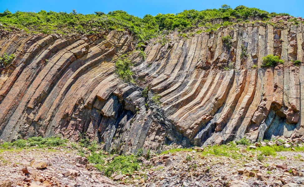
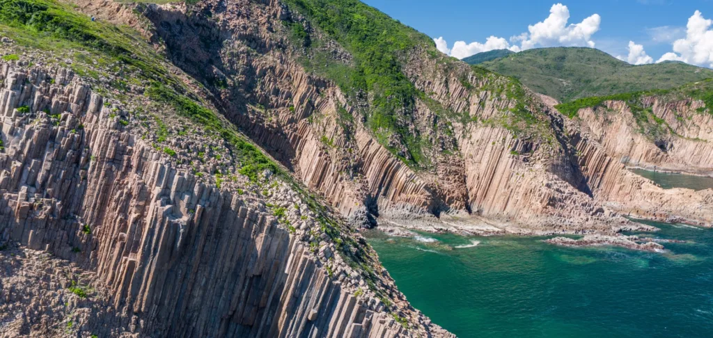
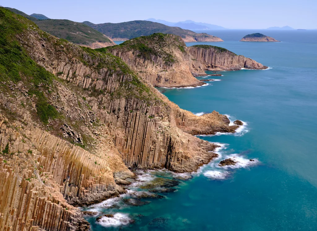
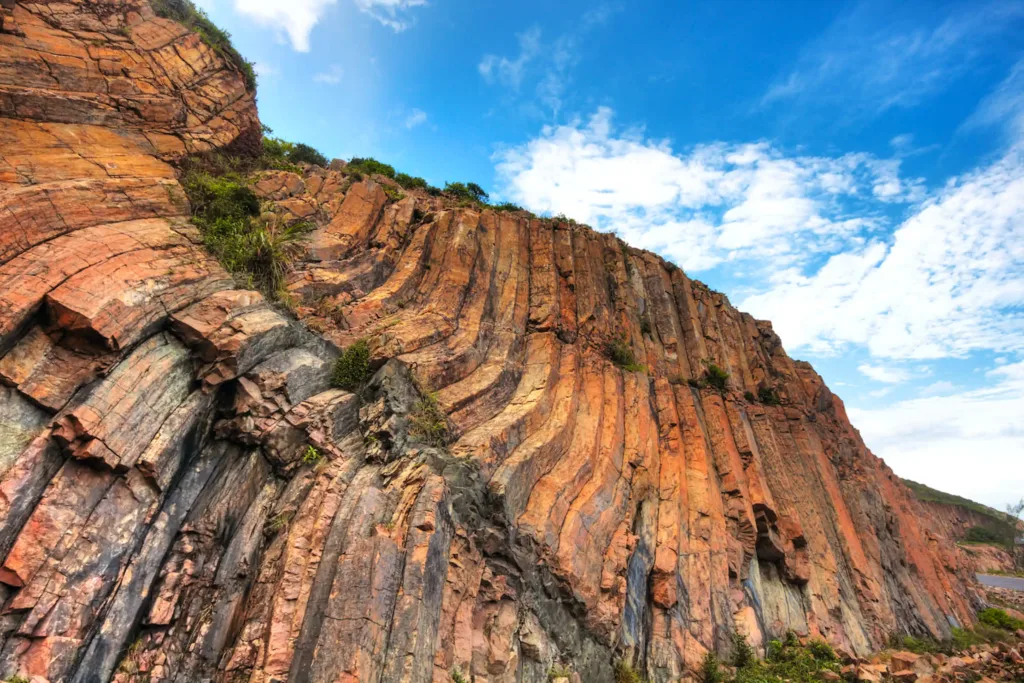
Basaltic Columns: One of the most iconic geological features in the geopark is the hexagonal columns of volcanic basalt. These columns, similar to those found at the Giant’s Causeway in Northern Ireland, were formed through the cooling and contraction of lava flows. The regular and often symmetrical shapes of these columns create a visually stunning and unique landscape.
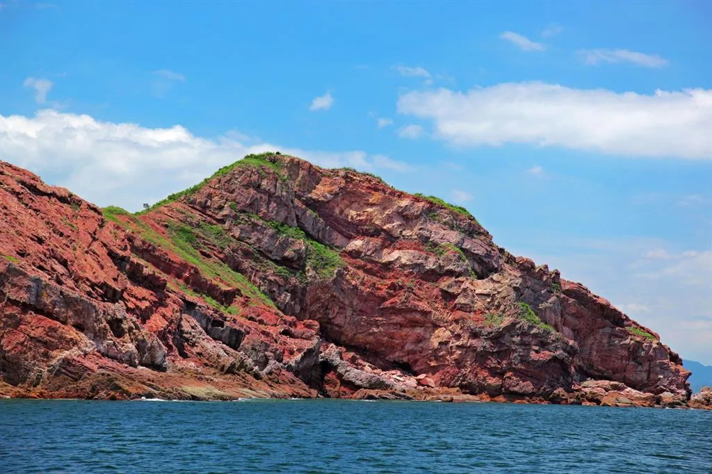
Sea Caves and Sea Stacks: The coastal areas of the geopark are adorned with sea caves and sea stacks, which are the result of coastal erosion, wave action, and weathering. These features offer not only fascinating geological insights but also serve as important habitats for various marine and bird species.
Folded Rocks: In the geopark, you can also find folded rock layers that are a testament to the tectonic forces that have shaped the region over millions of years. These folded rocks provide valuable information about the geological history of the area.
Unconformities: Unconformities, where there is a gap in the geological record due to erosion and sediment deposition, are visible in the geopark. They represent significant periods of Earth’s history and help geologists understand the sequence of events that shaped the landscape.
Volcanic Tuffs: The geopark contains layers of volcanic tuff, which are formed from volcanic ash and debris that have been compressed and solidified over time. These tuff layers hold important clues about the volcanic history of the region.
Granite Intrusions: Intrusions of granite can also be found in the geopark. These are formed when molten granite forces its way into existing rock layers. The contact between the granite and the surrounding rocks often results in distinct and visually striking patterns.
Fossil Beds: While less common, there are areas within the geopark where fossilized remains of prehistoric creatures can be found. These fossils provide insights into the ancient life that once thrived in the region.
The unique rock structures and geological formations in the Hong Kong UNESCO Global Geopark not only offer a window into the Earth’s geological history but also provide a stunning backdrop for outdoor enthusiasts, hikers, and those interested in understanding the natural processes that have shaped this captivating landscape over millions of years.
Hexagonal Rock Columns
Hexagonal rock columns, like the ones found in the Hong Kong UNESCO Global Geopark, are a fascinating geological feature known for their striking appearance and regular, hexagonal shape. These formations are typically composed of basalt and are created through a specific geological process. Here’s an explanation of hexagonal rock columns, the geological processes behind their formation, and a comparison to similar formations around the world:
Explanation of Hexagonal Rock Columns: Hexagonal rock columns are essentially columnar jointing structures, where rocks break or fracture into polygonal columns with six sides. These columns often appear as orderly, closely-packed, and often symmetrical arrays of hexagons. The most famous example of such formations is the Giant’s Causeway in Northern Ireland, but similar features can be found in various parts of the world, including the Hong Kong UNESCO Global Geopark.
Geological Processes behind Their Formation: The formation of hexagonal rock columns is primarily a result of the cooling and contraction of volcanic basalt. Here’s how the process unfolds:
- Magma Formation: It begins with the formation of molten magma deep within the Earth’s crust. This molten rock, which is rich in basalt, rises to the surface during volcanic eruptions.
- Rapid Cooling: As the magma comes into contact with the cooler air or water, it cools rapidly. This rapid cooling causes the basalt to contract and solidify quickly.
- Columnar Jointing: During the cooling process, the rock contracts and fractures into a pattern of closely-packed, often hexagonal columns. This columnar jointing is driven by the fact that hexagons are the most efficient way to partition space with the least amount of material, making it a natural outcome of the cooling process.
- Vertical Columns: The columns tend to be vertically oriented, and the geometric regularity of the hexagonal shape is a product of the efficient packing of columns as the basalt cools and contracts.
Comparison to Similar Formations Around the World: Hexagonal rock columns are relatively rare, but they can be found in various locations worldwide. Some of the most famous examples include:
- Giant’s Causeway, Northern Ireland: The Giant’s Causeway is one of the most iconic locations for hexagonal rock columns. It features an extensive area of basalt columns that have captivated visitors for centuries.
- Devils Postpile National Monument, USA: Located in California, this site showcases impressive hexagonal columns formed from cooling lava. It’s a well-known example in the United States.
- Fingal’s Cave, Scotland: This sea cave on the uninhabited island of Staffa in Scotland boasts striking hexagonal columns, creating a unique and ethereal landscape.
- Hong Kong UNESCO Global Geopark: As mentioned earlier, the geopark in Hong Kong also features basaltic columns that are not as extensive as some of the other famous sites but are nonetheless remarkable and accessible for exploration.
While the exact appearance and scale of hexagonal rock columns may vary from one location to another, the underlying geological process of rapid cooling and columnar jointing is the same, resulting in these visually captivating and enigmatic formations.
Sedimentary Rocks
The Hong Kong UNESCO Global Geopark is not only known for its volcanic and igneous rock formations like the hexagonal columns but also contains significant sedimentary rock formations. These sedimentary rocks offer valuable insights into ancient environments and the geological history of the region. Here’s a description of some of the sedimentary rock formations in the geopark and what they reveal:
1. Mudstones and Siltstones: The geopark contains layers of mudstones and siltstones, which are fine-grained sedimentary rocks. These rocks typically form in quiet water environments such as lakes, river deltas, or the deep ocean. They are often rich in fossils, providing evidence of the ancient life that inhabited these environments. Fossils in these sedimentary rocks can include marine organisms, plants, and even traces of terrestrial animals.
2. Sandstones: Sandstone layers are also present in the geopark. Sandstone forms from the consolidation of sand-sized grains, which can be transported by water, wind, or deposited in a variety of terrestrial and shallow marine environments. The nature of the sandstone, including the size and sorting of the grains, can provide information about the conditions under which they were deposited.
3. Conglomerates: Conglomerates are sedimentary rocks made up of rounded gravel-sized particles that are typically cemented together. The presence of conglomerates can suggest past alluvial or fluvial environments, where streams or rivers transported and deposited gravel.
4. Ripple Marks and Cross-Bedding: These sedimentary structures can often be found in sandstone layers. Ripple marks are small-scale features formed by the movement of water, and cross-bedding results from the migration of sand dunes or underwater ripples. They provide clues about the ancient flow conditions, including the direction and velocity of water or wind.
5. Unconformities: In some cases, sedimentary rocks may exhibit unconformities, which are gaps in the geological record. Unconformities are typically the result of erosion, tectonic activity, or non-deposition, and they indicate periods of time where sedimentation ceased and the rocks were exposed to various geological processes.
The sedimentary rock formations in the geopark allow geologists to reconstruct the geological history of the region. By studying the composition, fossils, and sedimentary structures within these rocks, researchers can gain insights into the ancient environments that existed in Hong Kong, including the types of landscapes, bodies of water, and the flora and fauna that inhabited the area.
These sedimentary rocks can also provide valuable information about the tectonic history of the region, as changes in deposition and the nature of sedimentary rocks can be linked to tectonic events and shifts in the Earth’s crust. Overall, the sedimentary rock formations in the Hong Kong UNESCO Global Geopark are like pages in a geological history book, offering a glimpse into the region’s past and the Earth’s evolving landscape.
Coastal Erosion and Landforms
Coastal erosion and the resulting landforms are prominent features in the Hong Kong UNESCO Global Geopark. The combination of dynamic coastal processes and diverse rock formations has given rise to a variety of coastal landforms. Here’s an overview of these coastal erosion features and the landforms they create:
Sea Caves: Coastal erosion, driven by the relentless action of waves, has carved numerous sea caves along the rocky coastlines of the geopark. These caves vary in size and shape and often extend into the cliffs or rocky headlands. They provide a habitat for various marine organisms and serve as a captivating feature for visitors exploring the geopark by boat.
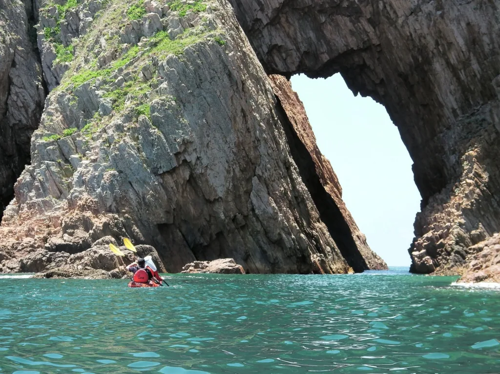
Sea Arches: In areas where coastal rocks are softer and more easily eroded, sea arches can form. These are natural archways carved through headlands by the erosive forces of waves and can create visually stunning natural bridges between land and sea.
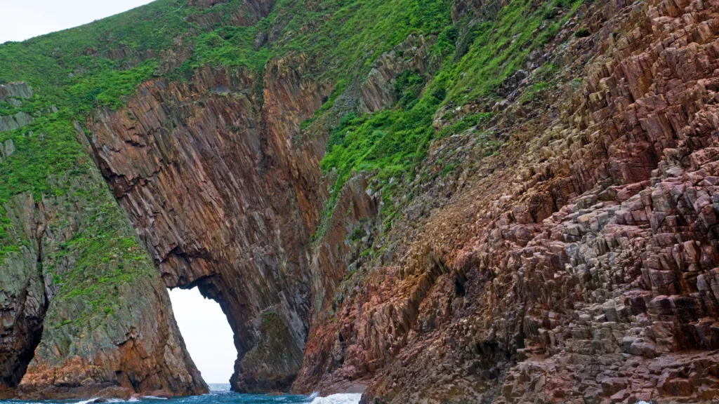
Stacks and Stumps: Over time, sea arches can evolve into sea stacks or stumps. Stacks are tall, isolated columns of rock that remain standing, while stumps are the remnants of stacks that have collapsed, leaving shorter, more rounded features.
Cliffs and Headlands: The relentless action of coastal erosion often results in the creation of cliffs and headlands. These towering rock formations line the coast and provide dramatic viewpoints for observing the sea, as well as insights into the underlying geology of the region.
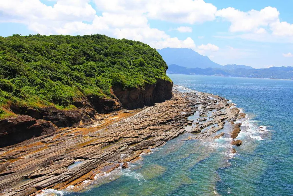
Wave-Cut Platforms: These flat or gently sloping rocky surfaces are formed by the abrasion of waves. They often extend out from the base of cliffs and are constantly shaped by wave action.
Tidal Inlets and Channels: Coastal erosion can lead to the formation of tidal inlets, channels, and estuarine systems. These provide a range of habitats for marine life, as well as opportunities for recreational activities like kayaking and boating.
Beaches: While the geopark’s beaches are not as extensive as those found in other coastal areas, there are sandy shores that have been shaped by coastal erosion. These beaches are often nestled between rocky headlands and provide unique settings for relaxation and exploration.
Coastal erosion is an ongoing process that continually shapes the landscape of the geopark. The erosion of various rock types, including basalt, has created a diverse and visually captivating coastal environment. It also provides a dynamic backdrop for understanding the impact of natural forces on the region’s geology and ecology.
Visitors to the Hong Kong UNESCO Global Geopark have the opportunity to witness these coastal landforms up close and appreciate the interplay between geological processes and the ever-changing coastline.


