Chalk is a soft, white, highly porous biochemical sedimentary rock composed almost entirely of calcite (CaCO₃) derived from the remains of coccolithophores, microscopic marine algae that once thrived in warm, shallow seas. Over millions of years, the accumulation of these tiny calcite plates produced thick layers of calcareous ooze, which later compacted and lithified into the rock we know today as chalk.
As a biochemical carbonate rock, chalk preserves an extraordinary fossil record of ancient ocean life and provides key insights into Earth’s climatic conditions during the Cretaceous Period. Famous white cliffs in England, France, and Denmark were all built by countless generations of microscopic algae settling quietly on ancient sea floors.
⭐ Quick Identification Summary
(Aynen bu biçimde yukarıya tablo yerleştirmen SEO açısından mükemmel olur.)
White Cliffs of Dover (UK), Étretat (France), Møns Klint (Denmark), Niobrara Chalk (USA)
Geological Formation of Chalk
Upper Cretaceous deposits of pure and bright white sedimentary chalk along the coast of central southern Cyprus.
Chalk formation begins with coccolithophores, small planktonic algae covered in intricate calcite plates called coccoliths. When these organisms die, their calcite plates slowly sink and accumulate as a fine white mud known as calcareous ooze.
During the Late Cretaceous—when global sea levels were high and vast continental shelves were submerged—this process occurred on an enormous scale. In some regions, over 500 meters of chalk accumulated, forming today’s massive cliffs and coastal formations.
Over time, the ooze underwent:
Compaction
Mild recrystallization
Weak cementation
Unlike harder limestones, chalk remains:
Soft
Porous
Fine-grained
Easily scratched
Yet it is geologically important due to its purity and its fossil content.
1. Coccolithophores: The Producers of Chalk
Coccolithophores are microscopic algae (5–100 microns) covered in armor-like plates of calcite called coccoliths. When these organisms die, their plates accumulate on the sea floor as a white, fine-grained ooze known as calcareous ooze.
Every gram of chalk contains billions of coccolith fragments.
2. Sedimentation in Shallow Seas
During the Late Cretaceous (100–66 million years ago), large parts of Europe and North America were covered by warm, nutrient-rich seas. These seas supported huge coccolith populations.
Dead coccolithophores accumulated continuously on the seabed:
1–2 cm of coccolith ooze could require thousands of years
Chalk beds can reach thicknesses of hundreds of meters
The slow, steady deposition created extremely fine-grained, homogeneous layers with few impurities.
3. Compaction and Lithification
Over geological time, deeper layers experienced:
Compaction from overlying sediment
Recrystallization of carbonate particles
Weak cementation between grains
Unlike limestone, which is often more crystalline, chalk remains:
Soft
Powdery
Very porous
Easily scratched or crumbled
This unique texture allows chalk to preserve fossils beautifully.
Mineral Composition of Chalk
1 Major Mineral: Calcite
Chalk is composed of:
95–99% calcite (CaCO₃)
Derived from coccolith plates
Calcite is responsible for chalk’s:
Softness
White color
Reactivity with acid
High porosity
2 Accessory Minerals
Small percentages (1–5%) may include:
Quartz
Clay minerals (kaolinite, illite)
Opal-CT
Iron oxides
Organic matter
These impurities can slightly alter:
Color
Hardness
Porosity
But high-purity chalk remains almost entirely calcitic.
Physical Properties of Chalk
chalk
Property
Description
Color
White, off-white, pale gray; impurities may add yellow or light brown tones
Texture
Earthy, soft, powdery; smooth to touch
Grain Size
Very fine-grained (microscopic coccoliths)
Porosity
High (up to 50% in some formations)
Hardness
Very soft (Mohs 1–3)
Reaction with Acid
Vigorous fizzing with dilute HCl
Cleavage/Fracture
Chalky, crumbly fracture
Density
Low compared to limestone (due to high porosity)
Types of Chalk
Chalk is generally subdivided based on impurities, texture, and depositional conditions.
4.1 Pure Chalk
95%+ calcite
Bright white
Homogeneous and soft
Forms famous cliffs (Dover, Étretat, Møns Klint)
4.2 Marl Chalk
Chalk mixed with 20–40% clay
Grayish color
More compact and harder
4.3 Hard Chalk / Chalk Limestone
Higher degree of cementation
Closer to limestone in strength
Often forms massive beds
5. Famous Chalk Formations Around the World
5.1 White Cliffs of Dover (England)
Perhaps the most iconic chalk formation on Earth—towering white cliffs composed almost entirely of coccolith remains.
5.2 Cliffs of Étretat (France)
Spectacular arches and spires formed in massive chalk deposits along Normandy’s coast.
5.3 Møns Klint (Denmark)
A dramatic 128-meter white cliff stretching 6 km along the Baltic coast.
5.4 Niobrara Chalk (USA)
Famous for marine fossils: mosasaurs, plesiosaurs, giant sea birds.
Chalk’s unique combination of characteristics, including its color, texture, composition, and historical uses, makes it a distinct and valuable rock type with significance in various fields, from geology and education to culture and industry.
Monument Rock, Large Chalk Formation
Fossils Found in Chalk
Chalk is known for its remarkable fossil preservation.
Common fossils include:
Coccoliths (dominant microfossils)
Foraminifera
Belemnites
Ammonites
Sponges
Sea urchins
Marine reptiles (Niobrara formations)
Because of chalk’s softness and porosity, fossils are often recovered intact and beautifully detailed.
7. Chalk vs. Limestone: What’s the Difference?
Feature
Chalk
Limestone
Composition
Almost pure calcite from coccoliths
Calcite from diverse sources (shells, chemical precipitation)
Texture
Very fine-grained, powdery
Can be fine to coarse
Hardness
Soft
Harder
Fossils
Mostly microfossils
Wide variety of fossils
Porosity
High
Lower
Environment
Deep or quiet marine
Many settings
Chalk IS a type of limestone, but a very special, biogenic, fine-grained variety.
8. Uses of Chalk
Chalk has dozens of applications across industry, agriculture, construction, and education.
8.1 Agriculture
Soil amendment for acidic soils (liming)
Improves crop yields
Increases pH and calcium levels
8.2 Construction
Ingredient in cement
Ingredient in plaster
Base material in some mortars
Filler for paints and coatings
8.3 Education
Traditionally used as:
School blackboard chalk
Field marking chalk
Drawing tools
Not all school “chalk sticks” today are real chalk
Most modern classroom chalk is calcium sulfate (gypsum), not true chalk.
8.4 Industry
Filler in plastics and rubber
Component in toothpaste
Whitening agent
Ingredient in ceramics
Polishing compounds
8.5 Decorative & Landscape Use
White pigments
Garden lime
Sculpting material
9. How to Identify Chalk (Field Identification)
Geologists identify chalk using several quick methods:
1. Finger Test
Soft enough to scratch easily with a fingernail.
2. Texture
Feels smooth, powdery, and dry.
3. Acid Test
Strong effervescence with dilute hydrochloric acid.
4. Color
Bright white or pale gray.
5. Powder Residue
Leaves a visible white powder on fingers.
These characteristics make chalk one of the easiest sedimentary rocks to recognize.
10. Chalk and Climate History
Chalk deposits serve as important geological records:
They indicate warm, shallow seas
High productivity of coccolithophores
Periods of global warmth (greenhouse climates)
Oceanic Anoxic Events (OAEs)
Cretaceous–Paleogene boundary effects
Studying chalk helps reconstruct ancient ocean conditions and biological evolution.influenced by the complex interplay of geological, environmental, and historical factors. Scientists and geologists study these chalk deposits to gain insights into Earth’s history and past marine environments.
Conclusion
Chalk is one of Earth’s most fascinating sedimentary rocks—formed from countless billions of microscopic marine organisms, preserved in towering oceanic cliffs, and widely used in agriculture, construction, and education. Its purity, softness, and characteristic white color make it easy to recognize, while its geological story connects us directly to the warm, shallow seas of the Late Cretaceous.
Auriferous silicified-decalcified siltstone-mudstoneLepidodendron fossil branch in ferruginous siltstoneSiltstone
Siltstone is a clastic sedimentary rock that formed from grains whose sized between that of sandstone and mudstone. It can found different environmental conditions different color and textures. Siltstone generally are red and gray color with flat bedding planes. Darker colored siltstone have plant fossils and other carbon-rich matter. It is hard and durable and do not easily split into thin particles or layer. Although often mistaken as a shale, siltstone lacks the fissility and laminations which are typical of shale. Siltstones may contain concretions. Unless the siltstone is fairly shaly, stratification is likely to be obscure and it tends to weather at oblique angles unrelated to bedding. Mudstone or shale are rocks that contain mud, which is material that has a range of silt and clay. Siltstone is differentiated by having a majority silt, not clay.
Depositional
Environment: Flood plain, Delta, or Mid-continental Shelf
Grain size: Fine-
grained
Siltstone Composition
Clastic sedimentary rocks are deposited in three ways. They
are water glaciers and wind. Identifying siltstone and shale requires
distinguishing between silt and clay particles.Silt and clay are both tiny
particles that have weathered away from rocks and minerals. Silt is
intermediate in size between the larger grains of sand and the smaller clay
particles. To be classified as silt, the particles must be smaller than .06
millimeters in diameter, (.002 inches) and larger than clay-size particles,
which are smaller than .004 millimeters in diameter (.0002 inches). Clay,
unlike silt, also refers to several types of minerals, including
montmorillonite and kaolinite
Siltstone Formation
Semi-quiet depositional environments. Coarse silt is capable of forming cross laminations in a current, while the finer-end particles generally deposit from suspension.
Thus, any depositional environment with these conditions may form silt deposits, and they range from river systems, to deltas, to shelves, to submarine fans and basins. In other words, just about anywhere.
Silt is a common component with other deposits, or is interbedded with other deposits. For example, silt beds are common in flood plain deposits above the point bar sands, and they form the TD unit in a Bouma sequence.
Where is It Found?
Siltstone is deposited in a similar environment with shale,
but is usually located near the old delta, lake or sea shore, where calm
currents cause less particle suspension. Siltstone is generally formed adjacent
to sandstone deposits – ie close to beaches and delta edges where sand is
deposited. It consists of silt, hence siltstone, sandy beaches and water
adjacent to deltas. Declining currents filter sand from smaller silt particles.
Siltstone rises to the shale level in deep water; where the suspended clay
particles are stored further as the currents continue to lose energy. In both
cases, calm water is needed to suspend and separate silt and clay. Thus,
sandstone, siltstone and shale are interrelated rocks which are distinguished
by particle size.
Siltstone Characteristics and Properties
Generally uniform, moderately consolidated to
semi-lithified, silty sediment.
Typically blue-grey to olive green and brown;
fracture surfaces are stained orangebrown to black.
Local intervals of colluvium.
No macroscopic shell, plant or fossil material.
Little or no evidence of bedding or other
sedimentary structures.
Found beneath the coarse alluvium/colluvium
sequence and above ‘basement’ lithologies such as granite, rhyolite and
metasedimentary rocks.
Siltstone Uses
It is
rarely mining for use as a construction material or manufacturing feedstock.
The pore
spaces of siltstone serve as good aquifer. It is rarely porous enough or
extensive enough to serve as an oil or gas reservoir.
Its main
use is as a low-quality fill when better materials are not locally available.
Shale, Siltstone, and Mudstone
Resistance to weathering: Shale, siltstone, and mudstone units are
valley formers, producing gentle slopes and subdued landforms, including broad
“V”-shaped gullies having long, gentle stream gradients.
Drainage: Shale, siltstone, and mudstone units have relatively low permeability,
resulting in significant surface flow. This produces a high drainage density.
The low permeability of shale and clay keeps water in the vicinity of plant
roots, so, in general, shale and clay will support dense vegetation. This often
obscures the surface of shale and further lowers the reflectance.
Color: Shale is commonly dark because of the lithic content, dark clay minerals,
and carbonaceous matter, which is frequently a constituent of shale. The dark
color of shale is usually indicative of marine origin. Marine shale dominates
in frequency, areal distribution, and thickness. Fluvial and lacustrine shale
have higher reflectances and often contain more silt. Siltstone, an abundant
sedimentary rock type that is probably more prevalent on the landscape than
shale, is often misidentified and labeled as shale by engineers. The mechanical
properties of siltstone make siltstone an important class from an
engineering/rock strength standpoint as well.
Structure: Shale can form thick, dense deposits, but shale response to tectonic forces
is quite different from sandstone. Shale responds to deformation by forming
numerous lenticular shear planes having separations measured in millimeters to
centimeters. Hence, shale tends to be weak, requiring support for bearing
loads. In addition, depending upon the type of clay minerals present, shale may
present shrink/swell problems (smectite and chlorite minerals), or
squeeze/deformation problems (kaolinite and chlorite minerals).
Siltstone Key Point
Silt does
not have a precise composition. It usually has a mix of micas, feldspar, quartz
and clay minerals. The small part of the silt is mostly clay. The rough size
fraction is mostly quartz and feldspar grains.
It is
mudstone and shale, mud-containing, clay and silt. Siltstone is different
because it is mostly clay and not clayy.
Silt stone
is much less common than shale and sandstone. Rocks are generally thinner and
less common.
Silt
accumulates in sedimentary basins all over the world. A current between the
sludge and the place where the sand is deposited represents the level of wind
or wave energy. These include aeolian, fluvial, tidal, lakrin, coastal,
glacier, paludal, deltaic and shelf environments. Sedimentary structures such
as stratification, fluctuation traces, erosion, cross bed and fossils provide
evidence of these environments.
Silt-sized
particles range from 0.00015 to 0.0025 inches in diameter or in the range of 0.0039
to 0.063 millimeters in diameter. They are of medium size between the coarse
clay on the small sides and the fine sand on the large side.
Coarse
silt grains are large enough for most people to see without using a magnifying
glass.
It can be
difficult to identify without close inspection and requires a small piece to be
broken to observe grain size. Scratch the surface with a knife blade or a nail,
instead of changing the grains of sand, small silt grains emerge.
Although
this test is not recommended, it is known that experienced geologists and soil
scientists can detect a few female silt fragments by gently inserting them
between their front teeth.
Siltstone
has little use. If used for building, it is only due to availability, not
quality. When there are no better local materials, the main use is a low
quality filler.
References
Bonewitz, R. (2012). Rocks and minerals. 2nd ed. London: DK Publishing.
Wikipedia contributors. (2019, March 20). Siltstone. In Wikipedia, The Free Encyclopedia. Retrieved 17:04, May 9, 2019, from https://en.wikipedia.org/w/index.php?title=Siltstone&oldid=888677754
The Geological Story of Energy Trapped in Sedimentary Environments
Oil shale may appear at first glance as an ordinary dark-colored sedimentary rock. It’s finely layered, often clay-rich, and for most people doesn’t go beyond being “a black thing.” But from a geological perspective, oil shale is a special record where time, biology, and chemistry work together.
This rock is neither a classic fossil fuel nor an ordinary sedimentary rock. It doesn’t contain oil; but it stores organic matter that can be converted to oil under the right conditions. In this respect, oil shale is an intermediate form that has locked Earth’s energy potential within a rock matrix.
Understanding oil shale means understanding not only energy geology, but also ancient lake systems, oxygen-poor environments, organic matter preservation, and the evolution of sedimentary basins.
What Is Oil Shale?
Oil shale rock showing dark laminated texture and kerogen-rich sedimentary layers
Oil shale is a sedimentary rock that contains significant amounts of kerogen and generally has a fine-grained and layered structure. Kerogen is not oil dissolved or in free form within the rock; rather, it’s solid organic matter that can produce liquid and gaseous hydrocarbons when heated.
At this point, it’s necessary to clarify the basic distinction:
Oil shale → is rock, contains kerogen
Oil → is fluid hydrocarbon, exists in migrated form within rock
So oil shale isn’t “rock containing oil,” but rock with the potential to produce oil.
The Sedimentary Origin of Oil Shale
The formation of oil shale is directly related to sedimentary environments. These rocks generally form:
In closed or semi-closed basins
In lake environments with poor circulation
In shallow marine, oxygen-poor areas
The common characteristic in such environments is: 👉 Organic production is high, decomposition is low.
Algae, plankton, and microscopic organisms multiply in the water column. When they die, they accumulate at the bottom. Under normal conditions, this organic matter would contact oxygen and decompose. However, in oil shale environments:
Bottom waters are oxygen-poor
Bacterial decomposition is limited
Organic matter is preserved
This preserved organic matter is eventually buried among sediments and compressed together with the rock matrix.
The Formation and Evolution of Kerogen
Kerogen is not a simple “organic residue.” It’s a structure that has transformed from biological matter to geochemical matter over long geological time.
This transformation goes through these stages:
Biological production (algae, plankton, plant remains)
Sedimentation (burial of organic matter together with clay and silt)
Diagenesis (chemical reorganization at low temperature)
Kerogenization (formation of complex, insoluble organic structure)
Kerogen is fixed within the rock. It doesn’t migrate. However, it can be broken down when sufficient temperature is provided.
Kerogen Types and Oil Shale Relationship
Kerogen is classified into different types according to its origin:
Type I Kerogen
Is algal in origin
Oil yield is very high
Found in the most valuable oil shale types
Type II Kerogen
Algae + plankton mixture
Produces both oil and gas
Common in marine oil shales
Type III Kerogen
Is plant in origin
Gas production is dominant
Closer to coalification
Type I and Type II kerogen dominate in most oil shales. This explains their liquid hydrocarbon potential.
Physical Properties
Oil shale typically shows fine lamination and dark coloration due to high organic content.
The physical properties of oil shale are determined by the combined effect of the mineral matrix and organic content:
Texture: Fine-grained, generally laminated
Color: Gray-black, dark brown
Layering: Distinct, sedimentary in origin
Strength: Medium – brittle
Porosity: Low–medium
In some oil shale specimens, a slight oily sheen can be seen on fresh fracture surfaces. This isn’t directly oil; it’s the visual effect of organic matter presence.
Chemical and Mineralogical Structure
Mineral composition is mostly:
Clay minerals
Quartz
Calcite / dolomite
Feldspars
Chemically:
High total organic carbon (TOC)
Variable silica and carbonate ratios
Complex relationship of organic-inorganic phases
are present.
The main factor that separates oil shale from ordinary claystone is the amount and preservation form of organic matter.
The Relationship Between Oil Shale and Petroleum Systems
Oil shales are often confused with the source rock of petroleum systems. The difference between them is important:
Oil shale: Contains kerogen → produces oil → oil stays in rock
Therefore, oil shales often represent immature or semi-mature systems.
Global Oil Shale Reserves
Oil shale deposits are widespread globally and some have extraordinary thickness. These rocks have generally developed:
Eocene–Miocene age
Lake origin
In closed basin systems
In many countries, oil shale has been considered as an alternative to conventional oil sources.
Economic Potential and Limitations
The appeal of oil shale is clear: 👉 Very large volumes 👉 High energy potential
But its limitations are also clear:
Processing requires energy
Water consumption is high
Environmental impacts are serious
Therefore, oil shale is viewed not as “easy energy” but as technology-dependent potential.
Misconceptions
Oil Shale ≠ Shale Oil
Shale oil is free oil within rock. Oil shale is rock with the potential to produce oil.
Not All Black Rocks Are Oil Shale
Color alone isn’t a criterion. Kerogen amount and type are determining factors.
Conclusion: The Energy Archive of Geological Time
Oil shale is not a rapidly formed rock. It’s the joint product of biological production accumulated over millions of years, chemical preservation, and sedimentary processes.
This rock shows us: Earth doesn’t just produce rock; it also writes energy potential into rock.
Oil shale is one of the quietest but most concentrated lines of this writing.
Shale is the quiet giant of the sedimentary world. It doesn’t have the visual drama of sandstone cliffs or the crystalline sparkle of limestone caverns, yet it dominates Earth’s sedimentary crust more than any other rock. With its fine grain, fissile structure, and tendency to break into thin sheets, shale carries within it the history of ancient seas, lakes, deltas, and entire ecosystems that lived and died within mud.
Shale is the rock that records whispers — the slow settling of clay-sized particles, the calm waters of ancient basins, the burial of organic matter, and the chemical evolution of Earth’s oceans and continents. Because shale forms in low-energy environments, it often becomes a natural archive of fossils, geochemical signatures, and environmental conditions.
Below is a fully detailed and globally relevant overview of shale, including its formation, composition, properties, varieties, fossil content, economic significance, and geological role.
1. What Is Shale? (Definition)
Shale is a fine-grained clastic sedimentary rock composed primarily of:
clay minerals
silt-sized quartz
feldspar
micas
organic matter
The defining property of shale is fissility — the tendency to split into thin layers due to the alignment of clay minerals. This feature distinguishes shale from other mudrocks such as mudstone and siltstone.
Key Characteristics
Very fine grain (less than 0.004 mm)
Fissile (breaks into sheets)
Typically formed in calm-water environments
Often rich in fossils
Can contain organic-rich black layers
Shale accounts for over 70% of all sedimentary rocks on Earth.
2. How Shale Forms (Sedimentary Processes)
Shale originates from the deposition and compaction of clay and silt in low-energy environments where tiny particles can settle out of suspension.
2.1. Deposition
Clay and silt grains are transported by:
rivers
waves
wind
glacial meltwater
They settle in environments where water movement is slow or stagnant:
deep marine basins
continental shelves
deltas
floodplains
lakes
lagoons
2.2. Compaction
As more sediment accumulates, pressure compacts the clay minerals. Water is expelled, and the particles align parallel to bedding, creating fissility.
2.3. Lithification
Chemical cements such as quartz, calcite, or iron oxides bind grains into solid rock over millions of years.
3. Composition of Shale (Mineralogy & Chemistry)
Shale contains a mix of clay minerals and fine silt particles. Composition varies with environment, but generally includes:
Clay Minerals
Kaolinite
Illite
Smectite (montmorillonite)
Chlorite
Silt Components
Quartz
Feldspar
Muscovite
Biotite
Chemical Composition (Generalized)
SiO₂: 55–70%
Al₂O₃: 10–20%
Fe₂O₃ + FeO: 4–8%
K₂O + Na₂O: 2–5%
Organic carbon: varies from <1% to >10%
Organic-rich shales (black shales) can be exceptionally carbon-rich.
4. Physical & Optical Properties of Shale
Shale’s unique properties control its behavior in erosion, weathering, and hydrocarbon systems.
Physical Properties Summary
Color: gray, black, green, red, yellow
Texture: very fine-grained
Structure: fissile; thin lamination
Hardness: generally 2–3 (soft)
Density: 2.3–2.6 g/cm³
Porosity: variable; up to 10–20% in organic shales
Optical and Surface Properties
Although shale is mostly opaque, it displays:
dull to earthy luster
thin lamination visible under hand lens
smooth, powdery surface when scratched
color variations indicating depositional environment
Black shales may show slight sheen due to organic matter or microscopic pyrite.
Shale is one of the best rocks for fossil preservation due to:
rapid burial
lack of oxygen
fine-grained sediment
gentle compaction
Common fossils include:
trilobites
brachiopods
bivalves
plant leaves
fish
microfossils (foraminifera, radiolarians)
Black shales may preserve entire organic-rich layers of ancient life.
8. Geological Importance of Shale
Environmental Archive
Shales preserve signatures of:
ocean chemistry
climate changes
anoxic events
mass extinctions
Hydrocarbon Source Rock
Many petroleum systems begin with organic-rich shale.
Global Carbon Cycle
Shale burial removes carbon from the atmosphere over geologic time.
9. Economic Importance
Shale plays major roles in:
1. Hydrocarbon Production
Source rock
Reservoir in shale gas systems
Host for tight oil
2. Industrial Applications
Ceramics
Bricks
Cement production
3. Rare Earth Elements
Some black shales contain uranium, molybdenum, vanadium, and REEs.
10. How to Identify Shale
Very fine grain
Softer than most sedimentary rocks
Splits into thin sheets
Smooth, layered, dull surface
Often dark-colored
Low permeability
A simple fingernail test often scratches shale easily.
Conclusion
Shale is a modest rock with extraordinary geological value. It is the planet’s most abundant sedimentary rock, recording ancient environments, preserving delicate fossils, storing carbon, and generating hydrocarbons. From deep marine basins to quiet lakebeds, shale quietly accumulates the smallest particles Earth produces — and in doing so, becomes one of the most informative materials in all of geology.
Skarn is coarse-grained metamorphic rocks that forms by a metasomatism. Also called tactites. Skarn tend to be rich in calcium-magnesium-iron-manganese-aluminium silicate minerals that also regerred to calc-silicate minerals. Skarn, in geology, metamorphic zone developed in the contact area around igneous rock intrusions when carbonate sedimentary rocks are invaded by large amounts of silicon, aluminum, iron, and magnesium. Many skarns also include ore minerals; several productive deposits of copper or other base metals have been found in and adjacent to skarns. Granitic and dioritic magmas are most commonly associated with skarns. Skarns can form by regional, or contact metamorphism and therefore form in relatively high temperature environments. The hydrothermal fluids associated with the metasomatic processes can originate from either magmatic, metamorphic, meteoric, marine, or even a mix of these.The resulting skarn may consist of a variety of different minerals which are highly dependent on the original composition of both the hydrothermal fluid and the original composition of the protolith.
Name origin: Skarn
names came from old Swedish mining term is silicate gangue, or waste rock,
associated with iron-ore bearing sulfide deposits
Colour: Black,
Brown, Colourless, Green, Grey, White
Skarns can be divided into sub-sections according to certain
criteria:
Skarn can be classified according to its Protolith. If
sakarn protolith is sedimentary origin, it can be reffered to as an exoskarn.
If the protolith is ignouse rock, it can be called an endoskarn.
Skarn also classification can be made based on the protolith
by observing the skarns dominant composition and the resulting alteration
assemblage. If the skarn has a Olivine, Serpentine, Phlogopite, magnesium
Clinopyroxene, Orthopyroxene, Spinel, Pargasite, and minerals s from the Humite
group, are characteristic of a dolomitic protolith and can be classed as a
magnesian skarn.
Calcic skarns are
replacement products of a limestone protolith with dominant mineral
assemblages containing Garnet, Clinopyroxene, and Wollastonite.
Skarn deposits have typical skarn Gangue minerals but also
contain ore minerals in abundance which are of economic importance. Skarn
deposits are therefore classified by their dominant economic element, such as
copper (Cu) skarn deposit, or molybdenum (Mo) skarn deposit to name a few.
Fe (Cu, Ag, Au) skarn
deposits
The tectonic setting for calcic Fe skarns tends to be the
oceanic island arcs. The host rocks tend to be gabbros to syenite associated
with intruding limestone. The tectonic setting for magnesium Fe skarns tends to
be the continental margin. The host rocks tend to be granodiorite to granite
associated with intruding dolomite and dolomitic sedimentary rocks. Magnetite
is the principal ore in these types of skarn deposits which its grade yields
from 40 to 60 %. Chalcopyrite, bornite and pyrite are the minor ores.
Cu (Au, Ag, Mo, W)
skarn deposits
The tectonic setting for Cu deposits tends to be the
Andean-type plutons intruding older continental-margin carbonate layers. The
host rocks tend to be quartzdiorite and granodiorite. Pyrite, chalcopyrite and
magnetite are typically found in higher abundances.
Types of Skarn Deposits
A descriptive skarn classification can be based on the
dominant economic minerals.
1. Iron Skarns
The largest skarn deposits, with many over 500 milliion
tonnes. They are mined for their magnetite. Minor amounts of Ni, Cu, Co and Au
may be present, but typically only Fe is recovered. They are dominantly
magnetite, with only minor silicate gangue.
2. Gold Skarns
Most gold skarns are associated with relatively mafic
diorite – granodiorite plutons and dyke/sill complexes. Some large Fe or Cu
skarns have Au in the distal zones. There is the potential that other skarn
types have undiscovered precious metals if the entire system has not been
explored.
3. Tungsten Skarns
These are found in association with calc-alkaline plutons in
major orogenic belts. They are associated with coarse grained, equigranular
batholiths (with pegmatite and aplite dykes), surrounded by high temperature
metamorphic aureoles. This is indicative of a deep environment.
4. Copper Skarns
These are the world’s most abundant type and are
particularly common in orogenic zones related to subduction both in continental
and oceanic settings. Most are associated with porphyritic plutons with
co-genetic volcanic rocks, stockwork veining, brittle fracturing, brecciation
and intense hydrothermal aleteration. These features are all indicative of a
relatively shallow environment. The largest copper skarns can exceed 1 billion
tonnes and are associated with porphyry copper deposits.
5. Zinc Skarns
Most occur in continental settings associated either with
subduction or rifting. They are also mined for lead and silver, and are high
grade. They form in the distal zone to associated igneous rocks.
6. Molybdenum Skarns
Most are associated with leucocratic (lacking ferromagnesian
minerals) granites and form high graade, small deposits. other metals are also
commonly associated, the most common being Mo-W-Cu skarns.
7. Tin Skarns
These are almost exclusively associated with high silica
granites generated by partial melting of continental crust. Greisen alteration
by fluorine produces a characteristic yellowish mica.
Composition of Skarn
Skarn is composed of of calcium-iron-magnesium-manganese-aluminum silicate minerals. Skarn deposits are economically important valuable sources, which metals such as tungsten, manganese, gold, copper, zinc, nickel, lead, molybdenum and iron.
A skarn is formed by consists of various metasomatic
processes during the metamorphism between two adjacent lithological units. Skarn
can form in almost any lithology type such as shale, granite and basalt but the
majority of skarns are found in lithology containing a limestone or a dolomite.
It is common to find skarns near plutons, along faults and major shear zones,
in shallow geothermal systems, and on the bottom of the sea floor. The
mineralogy of skarn rock usually highly related to the protolith.
Skarn minerals are mostly garnets and pyroxene with a wide variety of calc-silicate and associated minerals. Skarn minerals is include pyroxene, garnet, idocrase, wollastonite, actinolite, magnetite or hematite, epidote and scapolite. Because skarns are formed from incompatible-element rich, siliceous aqueous fluids a variety of uncommon mineral types are found in the skarn environment, such as: tourmaline, topaz, beryl, corundum, fluorite, apatite, barite, strontianite, tantalite, anglesite, and others.
Skarn Formation
In general, there are two main tyoes of skarns that are
exoskarns and endoskarns.
Exoskarns are more common than endoskarns. Exoskarns
form on the except intrusive body than
comes into contact with carbonate units.They are formed when fluids left over
from the crystallisation of the intrusion are ejected from the mass at the
waning stages of emplacement. When these fluids come into contact with reactice
rocks, generally carbonates rock such as limestone or dolomite, the fluids
reacting them, so producing alteration. Also other name of this production
infiltration metasomatism
Endoskarns forming within the intursive body where
fracturing, cooling joints, and stockworks have been produced, which results in
a permeable area. The permeable area can incorporate from the carbonate layer.
The magmatic hydrothermal fluids that
were transported or created by the intrusion interacts with the
carbonate material and forms the endoskarn. Endoskarns are considered to be
rare. Both the composition and the textures of protolith strongly play a role
in the formation of the resulting skarn
On the other hand reaction skarn is formed from isochemşcak
metamorphism occuring on thinly interlayered sedimentary lithology units that
involves a small scale (perhaps centimetres) metasomatic transfer of components
between adjacent units.
Skarnoid is a calc-silicate rock than is fine-grained rock
but iron poor. It founded lies between a hornfels and a coarse-grained skarns.
Generally the skarnoid tends to reflect the composition of the protolithic
rock.
Skarn deposit mostly experience a transition from early metamorphism which forms hornfels,
reaction skarns, and skarnoids to late metamorphism which forms relatively
coarser grained, ore-bearing skarns. The magma intrusion triggers contact
metamorphism in the region where sedimentary rocks are present and form as a
result.The recrystallization and phase change of a hornfel reflect the
composition of the protolith. After the formation of a hornfel, a process
called metasomatism occurs which involves hydrothermal fluids associated with
magmatic, metamorphic, marine, meteoric or even a mix of these. This process is
called isochemical metamorphism and can result in the production of a wide
range of calc-silicate minerals that form in impure lithology units and along
fluid boundaries where small-scale metasomatism occurs (argillite and
limestone, and banded iron formation).
An antiskarn is a calc-silicate rock that formed by direct
metasomatism of silicate rocks by a carbonatite magma.These rocks are
characterised by a high-temperature assemblage of diopsidic clinopyroxene,
olivine and wollastonite, and an apparent lack of igneous calcite.
Skarn Uses
A variety gemstones
have been founded skarn deposits, with garnet, ruby, and sapphire being common
occurrences in skarn.
Creating Artwork,
Gemstone, Jewelry, Metallurgical Flux, Source of Magnesia (MgO)
As a Flux in the
Production of Steel and Pig Iron, As a Sintering Agent in Steel Industry to
process Iron Ore, As Dimension Stone, Gold and Silver production, Manufacture
of Magnesium and Dolomite Refractories
As Building Stone, As
Facing Stone, Garden Decoration, Paving Stone
Other Important Information About
Skarn
Rocks that contain
garnet or pyroxene as major phases, are fine-grained, lack iron, and have
skarn-like appearances, are generally given the term skarnoid. Skarnoid
therefore is the intermediate stage of a fine-grained Hornfel and a
coarse-grained skarn.
Uncommon types of
skarns are formed in contact with sulfidic or carbonaceous rocks such as black
shales, graphite shales, banded iron formations and, occasionally, salt or
evaporites. Here, fluids react less via chemical exchange of ions, but because
of the redox-oxidation potential of the wall rocks
References
Bonewitz, R. (2012). Rocks and minerals. 2nd ed.
London: DK Publishing.
Wikipedia contributors. (2019, April 29).
Skarn. In Wikipedia, The Free Encyclopedia. Retrieved 22:48, May 7, 2019, from
https://en.wikipedia.org/w/index.php?title=Skarn&oldid=894634204
Sandstone is one of the most widespread sedimentary rocks on Earth, formed through the accumulation and cementation of mineral grains — mainly quartz and feldspar. These grains, carried by wind, rivers, or ocean waves, slowly build up layers that preserve the history of ancient environments.
From golden deserts to coastal cliffs, sandstone landscapes reveal how Earth’s surface has changed over millions of years.
What is Sandstone?
Sandstone is a clastic sedimentary rock composed mainly of sand-sized mineral grains ranging from 0.0625 to 2 mm in diameter. These grains are typically bound together by natural mineral cements such as silica, calcium carbonate, or iron oxides.
The mineral composition of sandstone is dominated by quartz and feldspar, with smaller amounts of mica, clay minerals, and lithic fragments. Quartz-rich sandstones are especially common due to quartz’s high hardness and chemical stability.
Sandstone displays a wide range of colors, including white, yellow, red, brown, and gray. These variations are largely controlled by the type of cement and the presence of mineral impurities, particularly iron oxides.
Texturally, sandstone has a clastic fabric, with sand grains that are often visible to the naked eye. The rock typically feels gritty, similar to sandpaper. Grain shape and sorting vary depending on transport distance and depositional environment.
Sandstone is commonly porous and permeable, allowing it to store and transmit fluids such as water, oil, and natural gas. This property makes it one of the most important reservoir rocks in hydrogeology and petroleum geology.
Under metamorphic conditions, quartz-rich sandstone can recrystallize to form quartzite, usually during tectonic compression in orogenic belts.
Key Physical Characteristics
Other features: Gritty feel; visible sand grains
Texture: Clastic
Grain size: 0.0625–2 mm
Hardness: Variable (depends on grains and cement)
Color: White, gray, yellow, red, brown
Main minerals: Quartz, feldspar
Sandstone Composition
Sandstone is a clastic sedimentary rock composed mainly of sand-sized framework grains that are bound together by cementing materials. Its composition reflects the nature of the source rocks, as well as the weathering, transport, deposition, and diagenetic processes involved in its formation.
The main components of sandstone are:
Framework grains
Accessory (including heavy) minerals
Matrix
Cement
Together, these components provide key information about provenance, depositional environment, and sedimentary maturity.
Framework Grains
Framework grains form the structural skeleton of sandstone and usually constitute most of the rock’s volume.
Quartz
Quartz is the most abundant and most resistant framework mineral in sandstone. Its hardness and chemical stability allow quartz grains to survive intense weathering, long transport distances, and multiple sedimentary recycling events. As a result, quartz-rich sandstones are typical of mature depositional environments. Quartz grains commonly originate from felsic igneous rocks, metamorphic rocks, or recycled older sandstones and often show rounded shapes due to abrasion during transport.
Feldspar
Feldspar is generally the second most abundant framework mineral. It is less resistant to chemical weathering than quartz and therefore more common in sandstones deposited close to their source areas. Feldspars mainly occur as alkali feldspars and plagioclase feldspars, and their abundance provides clues about climate, transport distance, and sedimentary maturity.
Lithic Fragments
Lithic fragments are pieces of pre-existing igneous, metamorphic, or sedimentary rocks that have not yet broken down into individual mineral grains. Volcanic lithic fragments are especially common in sandstones derived from tectonically active regions. Their abundance generally decreases with increasing sedimentary maturity.
Accessory and Heavy Minerals
Accessory minerals occur in small amounts but are important indicators of sandstone provenance. Common examples include muscovite, biotite, zircon, tourmaline, rutile, garnet, and magnetite. Many of these are classified as heavy minerals due to their high density and resistance to weathering. The relative abundance of zircon, tourmaline, and rutile is commonly expressed by the ZTR index, which is widely used to assess sedimentary maturity and recycling.
Matrix
Matrix consists of fine-grained material occupying the spaces between framework grains. Based on matrix content, sandstones are commonly divided into:
Arenites, which contain little or no matrix
Wackes, which are matrix-rich and texturally less mature
Matrix content strongly influences porosity, permeability, and overall rock strength.
Cement
Cement forms during diagenesis and binds framework grains together. It plays a major role in controlling the mechanical and hydraulic properties of sandstone. The most common cementing materials are silica, calcite, and iron oxides, while other secondary cements may include clay minerals, feldspar overgrowths, gypsum, anhydrite, barite, and zeolites.
Classification of Sandstone
Sandstone is classified mainly on the basis of grain composition and texture. The most common types are:
Wacke – A “dirty” sandstone containing abundant fine-grained matrix.
Quartz Arenite – Dominated by quartz grains; typical of highly mature environments such as deserts and beaches.
Arkose – Contains significant feldspar; commonly forms near granitic source areas.
Lithic Sandstone (Graywacke) – Rich in rock fragments and matrix; often associated with tectonically active or deep-marine settings.
Color Variations and What They Mean
White or light gray: High purity quartz, minimal iron.
Yellow to brown: Iron oxide cement.
Red or pink: High iron content (hematite).
Green: Presence of glauconite or chlorite minerals.
Each color reflects the environmental and chemical conditions during formation.
Sedimentary Structures in Sandstone
Sandstones preserve remarkable features that record past geological events:
Cross-bedding: Indicates wind or water current directions.
Ripple marks: Formed by waves or flowing water.
Mud cracks: Evidence of drying in ancient riverbeds or floodplains.
Fossil traces: Footprints, shells, or burrows captured in stone.
These structures make sandstone invaluable for interpreting paleoenvironments and reconstructing ancient landscapes.
Sandstone Formation
Sandstone forms through the cementation of sand-sized grains that originate either as fragments of pre-existing rocks or as individual mineral crystals. These grains are typically bound together by natural cements such as silica, calcium carbonate, or clay minerals, which precipitate during burial and diagenesis.
In geology, sand-sized particles are defined as having diameters between 0.0625 mm and 2 mm. Finer sediments, such as silt and clay, form rocks like siltstone and shale, while coarser materials produce conglomerates and breccias. Sandstone occupies this intermediate grain-size range, giving it distinctive textural and physical properties.
The most common cementing materials—silica and calcium carbonate—often originate from the dissolution or alteration of minerals after deposition. The type and amount of cement strongly influence the strength, porosity, and durability of the resulting rock.
Sandstone colors are commonly tan, yellow, red, or brown, largely reflecting the mineral composition of the sand and the nature of the cement, particularly iron-bearing compounds.
The depositional environment plays a critical role in controlling sandstone characteristics, including grain size, sorting, composition, sedimentary structures, and overall rock geometry. These environments are broadly divided into terrestrial and marine settings.
Terrestrial Depositional Environments
Rivers (channel sands, point bars, levees)
Alluvial fans
Glacial outwash plains
Lakes
Deserts (sand dunes and ergs)
Marine Depositional Environments
Deltas
Beaches and shoreface zones
Tidal flats
Offshore bars and sand waves
Storm deposits (tempestites)
Turbidites (submarine channels and fans)
Uses and Applications
Sandstone has been used in construction, architecture, and engineering for thousands of years, valued for its durability, strength, workability, and natural appearance. Its wide range of physical properties allows it to serve both structural and decorative purposes.
In architecture, sandstone is commonly used for building facades and cladding. Its resistance to weathering and its natural color variations make it a popular choice for public buildings, museums, monuments, and historic structures.
Sandstone is also widely used for paving and flooring, particularly in outdoor settings such as walkways, patios, and pool surrounds. Its strength and naturally rough surface provide good slip resistance, making it suitable for high-traffic areas.
Because it can be easily carved and shaped, sandstone has long been used in monuments, sculptures, and ornamental stonework. Many historic statues and architectural details were crafted from sandstone for this reason.
In construction materials, crushed sandstone is used as gravel and aggregate in road construction, foundations, and concrete production.
Beyond construction, sandstone plays a crucial role in oil and gas exploration. Its porosity and permeability make it one of the most important reservoir rocks, allowing hydrocarbons and groundwater to be stored and transmitted within the subsurface.
Overall, sandstone’s combination of mechanical strength, aesthetic versatility, and geological significance makes it one of the most widely used sedimentary rocks on Earth.struction, architecture, and industry, and its durability and natural beauty make it a highly sought-after building material.
Geological Formations and Locations of Sandstone
Sandstone is one of the most widespread sedimentary rocks on Earth, forming wherever sand-sized sediments accumulate and later become compacted and cemented. Because sand can be deposited in many different environments, sandstone occurs in a wide range of geological settings, from continental interiors to marine basins.
Sandstone typically forms in environments such as:
River channels and floodplains
Beaches and coastal systems
Desert dune fields
Shallow marine shelves
Deep-marine submarine fans
Over geological time, these deposits may be uplifted, eroded, and exposed at the surface, forming some of the world’s most recognizable landscapes.
Major Sandstone Formations and Regions
Some of the most notable sandstone occurrences around the world include:
Colorado Plateau (USA) – Home to extensive sandstone sequences forming iconic landscapes such as the Grand Canyon and Zion National Park.
Navajo Sandstone (USA) – A massive Jurassic-age sandstone known for its large-scale cross-bedding and desert origin.
Appalachian Mountains (USA) – Sandstone units occur within folded and faulted sedimentary successions.
Petra (Jordan) – World-famous sandstone cliffs carved into monumental architecture.
Geological Significance
The global distribution of sandstone reflects the ubiquity of sand-producing processes such as weathering, erosion, and sediment transport. Because sandstone preserves sedimentary structures and stratigraphic relationships, it is a key rock type for reconstructing past environments, climates, and tectonic settings.
In addition to its geological importance, sandstone from many of these regions has been widely used as building stone, shaping both natural landscapes and human architecture.
Conclusion: A Rock That Records Time
Sandstone is more than a building material — it is a record of Earth’s deep history. Each sand grain carries the story of erosion, transport, deposition, and cementation, shaped over immense spans of geologic time.
From desert dunes and river channels to towering cliffs and coastal outcrops, sandstone preserves the environments in which it formed. Its layers capture ancient landscapes, shifting climates, and the slow but persistent processes that continually reshape the planet.
In this way, sandstone reminds us that Earth’s most striking features are not created in moments, but built grain by grain, layer by layer, through time itself.
References
Bonewitz, R. (2012). Rocks and Minerals (2nd ed.). London: DK Publishing.
Boggs, S. (2011). Principles of Sedimentology and Stratigraphy (5th ed.). Upper Saddle River, NJ: Pearson Education.
Tucker, M. E. (2001). Sedimentary Petrology: An Introduction to the Origin of Sedimentary Rocks (3rd ed.). Oxford: Blackwell Science.
Pettijohn, F. J., Potter, P. E., & Siever, R. (1987). Sand and Sandstone (2nd ed.). New York: Springer-Verlag.
Nichols, G. (2009). Sedimentology and Stratigraphy (2nd ed.). Chichester: Wiley-Blackwell.
U.S. Geological Survey (USGS). Sandstone. U.S. Department of the Interior.
https://www.usgs.gov
Encyclopaedia Britannica. Sandstone.
https://www.britannica.com/science/sandstone
Wikipedia contributors. (2019). Sandstone. In Wikipedia, The Free Encyclopedia.
Phyllite metamorphic rock with characteristic satiny sheen
The Intermediate Stage Where Rocks Change Silently
Some rocks shout. Their crystals shine, their veins are sharp, they make themselves known at first glance.
Some are silent. When you pick them up, they seem “insignificant.” But when you play with the light a bit, you notice a strange silky sheen on their surface. Neither completely flat, nor completely crystalline. Neither sedimentary, nor magmatic.
Phyllite is exactly such a rock.
In geology, phyllite is often described as an intermediate stop: After slate, before schist.
But this definition is incomplete. Because phyllite isn’t just a rock “stuck in between.” It represents the point where low-grade metamorphism works silently. It’s the stage where pressure increases, temperature gradually rises, minerals haven’t yet grown but are already starting to shift positions.
This article will treat phyllite not as a transitional stone, but as a geological record in its own right.
What Is Phyllite?
Phyllite rock surface displaying fine foliation and satiny luster
Phyllite is a fine-grained, foliated metamorphic rock that forms under low to medium-grade metamorphic conditions.
It generally forms from the metamorphism of fine-grained sedimentary rocks such as:
Shale
Mudstone
Siltstone
In geological positioning, phyllite:
Slate → phyllite → schist
is in the middle of this sequence.
But this isn’t just a sequence. This sequence is a living indicator of how increasing pressure and temperature transform rock texture.
Why Does Phyllite Look Different?
The first thing you notice when you pick up phyllite is usually a silky or satiny sheen. This sheen is not coincidental.
In slate, minerals are so small they can’t be distinguished by eye. In schist, minerals have grown noticeably. In phyllite, we’re at the exact midpoint.
Mica minerals (especially sericite and fine muscovite)
Reoriented layers
Mineral flakes aligned parallel to the surface
reflect light at certain angles. That’s why phyllite has:
Slightly wavy surfaces
A shiny but non-crystalline appearance
Fine foliation
This appearance shows that metamorphism hasn’t yet completed, but has reached a point of no return.
How Does Phyllite Form? (Geological Process)
Phyllite forms as fine-grained sedimentary rocks undergo increasing pressure and temperature during regional metamorphism.
Phyllite’s story begins with a sedimentary rock.
Initially:
Fine-grained muds settle
Layers form
Clay minerals dominate
When this rock begins to be buried deep:
Pressure increases
Temperature gradually rises
But there’s not yet:
Complete recrystallization
Formation of large crystals
At this stage, clay minerals reorient. Atoms don’t completely form new minerals, but existing structures are reorganized. Mica-like flakes emerge.
This point is phyllite.
It’s neither completely sedimentary, nor a fully metamorphic “mature” rock.
That’s why phyllite is the transitional moment of metamorphism.
Phyllite in Terms of Metamorphic Grade
Mineralogical structure of phyllite with fine mica and quartz minerals
Metamorphic rocks are generally classified by grade:
Low-grade
Medium-grade
High-grade
Phyllite sits in the transition from low-grade to medium-grade.
It develops at approximately:
300–450 °C temperature
Increasing directed pressure
conditions.
These conditions are frequently seen:
In continental collision zones
In mountain-building processes
In deep burial areas
That’s why phyllites are quite common in orogenic belts (mountain belts).
The Difference Between Phyllite and Slate and Schist
This comparison is the key to understanding phyllite.
Phyllite vs Slate
Slate is matte, phyllite is shiny
Slate is finer and sharper
Mineral orientation is more pronounced in phyllite
Phyllite vs Schist
In schist, minerals are distinguishable to the naked eye
In phyllite, minerals are microscopic
Schist has a coarser texture
These differences aren’t just name changes; they’re records of geological conditions.
Phyllite’s Texture and Foliation
Phyllite’s Texture and Foliation
Phyllite has distinct foliation. This foliation is:
Not sedimentary layering
Pressure-dependent orientation
Meaning the rock has reshaped itself in the direction it was compressed.
This causes phyllite to:
Easily separate layer by layer
Show not flat, but slightly wavy surfaces
This waviness shows that stress within the rock wasn’t homogeneous.
Where Is Phyllite Found?
Phyllite is generally found:
In old mountain belts
Within metamorphic basement rocks
In continental collision zones
Worldwide:
Alpine–Himalayan belt
Appalachian Mountains
Scotland
Central Europe
In Turkey, especially in metamorphic massifs
it’s widespread.
In Turkey, phyllites are frequently seen in areas that have undergone regional metamorphism and are often found together with schists.
Physical Properties of Phyllite
Phyllite is a rock that appears “ordinary” at first glance but exhibits quite distinctive physical properties when examined carefully. All of these properties are a direct result of it being a product of low–medium-grade metamorphism.
Phyllite’s most characteristic physical property is its silky (satiny) sheen. This sheen doesn’t come from a polished surface, but from microscopic mica flakes reflecting light at certain angles. When the rock is rotated, a wavy light movement is noticed on the surface.
Phyllite is:
Not completely matte (like slate)
Its crystals aren’t large enough to be distinguished by the naked eye (like schist)
This intermediate state is the most reliable way to identify phyllite.
Physical Properties of Phyllite – Table
Property
Value / Range
Explanation
Color
Gray, greenish gray, blackish
Depends on mineral content
Luster
Silky – satiny
Orientation of mica minerals
Texture
Fine-grained, foliated
Metamorphic foliation
Hardness (Mohs)
3 – 4
Due to mica minerals
Density
~2.6 – 2.8 g/cm³
Typical metamorphic rock density
Foliation
Distinct, wavy
Pressure-dependent orientation
Crystal size
Microscopic
Not distinguishable by eye
Parting
Easy along layers
Foliation planes
This table clearly shows us: Phyllite has structurally separated from sedimentary rock but isn’t yet a fully crystalline metamorphic rock.
Chemical and Mineralogical Properties of Phyllite
Phyllite’s chemical composition is largely inherited from the parent rock (protolith). Since most phyllites originate from clay-rich sedimentary rocks, their chemical composition parallels this.
Principal mineral components:
Fine-grained muscovite
Sericite
Chlorite
Quartz
Small amounts of feldspar
The common characteristic of these minerals is:
Having a layered structure
Easily orienting under pressure
General Chemical Composition (approximate)
Component
Explanation
SiO₂
From quartz and silicate minerals
Al₂O₃
Mica and clay-origin minerals
K₂O / Na₂O
Muscovite and feldspar contribution
FeO / MgO
Related to chlorite presence
In phyllite, chemical change is limited compared to high-grade metamorphic rocks. Here, the main change is:
Not atoms completely forming new minerals
But reorganization of existing minerals
This explains why phyllite is defined as a “transitional rock.”
Metamorphic Conditions: In What Environment Does Phyllite Form?
Regional metamorphism diagram showing pressure and temperature conditions for phyllite formation
Phyllite is the product of a specific pressure–temperature (P–T) range.
Approximate conditions:
Temperature: 300–450 °C
Pressure: Medium-level directed pressure
Environment: Regional metamorphism
These conditions generally develop in:
Continental collision zones
Mountain-building belts
Long-term burial areas
That’s why phyllite is often found not alone but together with:
Slates
Schists
Zones showing transition toward gneisses
Phyllite is a geological phase where rocks “haven’t yet decided.”
Engineering and Use Areas of Phyllite
Although phyllite is mineralogically interesting, it has limited industrial use. The reason is that its foliated structure isn’t always advantageous from an engineering perspective.
However, it’s not completely useless either.
1. Building Stone and Cladding (Limited)
Some phyllite types, when they are:
Regularly foliated
Aesthetically surfaced
Homogeneously textured
can be used as:
Wall cladding
Landscape stone
Decorative rock
However, it’s not preferred in structures requiring strength. Because there’s a risk of easy separation along foliation planes.
2. Importance as a Geological Indicator Rock
This is where phyllite’s real value emerges.
In geology, phyllite:
Is an indicator of metamorphic grade
Determines the boundaries of regional metamorphism
Carries traces of mountain-building processes
That’s why for field geologists, phyllite is:
Not an “intermediate rock”
But a key rock
Seeing phyllite in a region allows us to understand:
How deep that area was buried in the past
What types of pressures it was exposed to
Misconceptions: Is Phyllite a Weak Rock?
There’s a common misconception: “Phyllite is an intermediate rock, so it’s insignificant.”
This is incorrect.
Phyllite:
Isn’t weak
But shows directional weakness
Meaning:
Its resistance to pressure isn’t bad
But it’s prone to breaking along layer directions
This property doesn’t make it “bad,” but problematic when not used in the right place.
Conclusion: Phyllite Is the Record of Change
Phyllite is neither the beginning, nor the end.
It’s a phase where rocks change silently, where minerals haven’t yet grown but can no longer return to their former states.
That’s why phyllite is:
Not showy
But geologically extremely valuable
When you look at a piece of phyllite, you actually see: A moment where time, pressure, and patience work together.
Metamorphism doesn’t happen by shouting. Phyllite is the best proof of this.
Pegmatite is an igneous rock that form end of the stage a magma’s crystallization. Pegmatites contain exceptionally large crystals and they contain rarely minerals than other types of rocks. They have interlocking crystals usually larger than 2.5 cm in size. Generally most Pegmatites are found in sheets of rock that are dikes and veins Also near large masses of igneous rocks called batholiths.
Pagmatites most attractive feature is their crystal size,
average crystal size over than 5 cm. Individual crystals over 10 metres (33 ft)
long have been found, and many of the world’s largest crystals were found
within pegmatites. These include spodumene, microcline, beryl, and tourmaline.
Pegmatite crystal
texture form within pegmatitic rock may be taken to extreme size and
perfection. Feldspar within a pegmatite may display exaggerated and perfect
twinning, exsolution lamellae, and when affected by hydrous crystallization,
macroscale graphic texture is known, with feldspar and quartz intergrown.
Perthite feldspar within a pegmatite often shows gigantic perthitic texture
visible to the naked eye. The product of pegmatite decomposition is euclase.
Name origin: The
term of pegmatite derives from Homeric Greek, πήγνυμι (pegnymi), which means
“to bind together”
The pegmatite mineralogy is dominated by some form of
feldspar, frequently with mica and generally with quartz. Usually seeing that
pegmatite include most minerals associated with granite and granite-associated
hydrothermal systems. However, It is impossible to quantify the mineralogy.
Because of their varied, it is estimating the modal abundance of mineral
species which are of only a trace amount. This is because of the difficulty in
counting and sampling mineral grains in a rock which may have crystals from
centimeters to meters across.
Pegmatites is intruding mafic and carbonate-bearing
sequences include garnet, commonly almandine or spessartine
Syenite pegmatites are quartz depleted and contain large
feldspathoid crystals instead.
Formation of the Pegmatite
Igneous rocks formed large crystals are usually ttributed to a slow rate of crystallization but with pegmatites’ large crystals are attributed to low-viscosity fluids that allow ions to be very mobile.During the crystallization stage, the melt usually contains a significant amount of dissolved water and other volatiles such as chlorine, fluorine, and carbon dioxide. Early crystallization process, water is not removed. So its concentration in the melt grows as crystallization progresses. Finally there is an overabundance of water, and pockets of water separate from the melt. These pockets of superheated water are extremely rich in dissolved ions. The ions in the water are much more mobile than ions in the melt. This allows them to move about freely and form crystals rapidly. This is why crystals of a pegmatite grow so large.
The extreme conditions of crystallization sometimes produce
crystals that are several meters in length and weigh over one ton. Pegmatites
form from waters that separate from a magma in the late stages of
crystallization; this activity often occurs in small pockets along the margins
of a batholith. Pegmatite can also form in fractures that develop on the
margins of the batholith. This is how pegmatite dikes are formed.
Large intrusions of feldspathoid syenites are commonly
accompanied by pegmatites, veins, lenses and pods of coarse-crystalline
material comprising the same minerals as found in the surrounding rocks
(nepheline, sodalite, alkali feldspars, aegirine and sodic amphiboles), as well
as copious quantities of rare minerals enriched in water and incompatible trace
elements: Sr (lamprophyllite, belovite), Ba (barytolamprophyllite, batisite),
REE (rinkolite, belovite), Zr (eudialyte, lovozerite, catapleiite), Nb (labuntsovite,
loparite), Li (mangan-neptunite, tainiolite), Be (leucophanite, epididymite,
chkalovite) and Th (steenstrupine). There is little doubt that some of these
minerals crystallized from super-evolved melts left over after the formation of
the surrounding alkaline rock.
However, this early magmatic stage is commonly followed by
hydrothermal processes involving aqueous (and, in some cases, F- or CO3-rich)
fluids, which leave their distinct mineralogical overprint, like the
crystallization of fine-grained (sugary) albite, fibrous or spherulitic
aegirine, exotic carbonate minerals, natrolite and various other zeolites.
In some cases, the primary mineral assemblage and texture
are completely obliterated by late-stage hydrothermal reworking (metasomatism).
These complex associations of minerals are described collectively as pegmatites
or, to distinsguish them from their granitic counterparts, alkaline pegmatites.
Where is it found?
Pegmatite is found in all over the world. They are most
abundant old rocks.Some are found in large intrusive igneous rocks, while
others are scattered over rocks surrounding intrusive magmatic rocks.
Worldwide, notable pegmatite occurrences are within the
major cratons, and within greenschist-facies metamorphic belts. Aplite and
porphyry dikes and veins may intrude pegmatites and wall rocks adjacent to
intrusions, creating a confused sequence of felsic intrusive apophyses (thin
branches or offshoots of igneous bodies) within the aureole of some granites.
Characteristics and Properties of Rock
Pegmatites can be classified according to the elements or
mineral of interest, for instance “lithian pegmatite” to describe a
Li-bearing or Li-mineral bearing pegmatite, or “boron pegmatite” for
those containing tourmaline.
There is often no meaningful way to distinguish pegmatites
according to chemistry due to the difficulty of obtaining a representative
sample, but often groups of pegmatites can be distinguished on contact
textures, orientation, accessory minerals and timing. These may be named
formally or informally as a class of intrusive rock or within a larger igneous
association.
While difficult to be certain of derivation of pegmatite in
the strictest sense, often pegmatites are referred to as
“metamorphic”, “granitic” or “metasomatic”, based
on the interpretations of the investigating geologist.
Rocks with similar texture to pegmatites are called
pegmatitic.
Pegmatite Uses
Pegmatite are used as
architectural stone. If the pegmatite is sound and attractive, it might be cut
into slabs and polished for building facing, countertops, tile or other
decorative stone products and sold commercially as a “granite.”
Pegmatite is used for
rare mineral mining. These minerals can be commercial sources of: beryllium,
bismuth, boron, cesium, lithium, molybdenum, niobium, tantalum, titanium,
tungsten, and many other elements.
Pegmatite is
frequently mined for industrial minerals. Large sheets of mica are mined from
pegmatite. These are used to make components for electronic devices,
retardation plates, circuit boards, optical filters, detector windows, and many
other products. Feldspar is another mineral frequently mined from pegmatite. It
is used as a primary ingredient for making glass and ceramics. It is also used
as a filler in many products.
Facts About The Rock
Crystals of pegmatite grow large because of the extreme conditions of crystallization. Basically, the presence of residual water has allowed the magma to cool slowly to permit coarse crystal growth.
Complex pegmatites result because of the presence exotic volatiles such as chlorine, fluorine, and carbon dioxide.
The extreme conditions may produce crystals many feet in length and may weigh more than a ton.
An example of a very large crystal of spodumene is at the Etta Mine in South Dakota. It was 42 feet long, 5 feet in diameter, and yielded about 90 tons of spodumene.
Pegmatite also forms in small pockets along the margins of a batholith leading to pegmatite dikes. It will form from waters that separate from a magma in the late stages of crystallization.
The dikes and pockets are small in size, taking place underground following a dike or a small pocket. Pegmatites usually do not support large mining operations.
Rare elements concentrated in large crystals may make pegmatite a potential source of valuable ore. Pegmatite deposits may also contain gemstones, industrial minerals, and rare minerals.
Overall pegmatite rock has very few uses.
It has limited use as an architectural stone and is sometimes encountered in a dimension stone quarry that is producing granite.
Pegmatite, if sound and appealing, might be cut into slabs, polished, and used for building facades, countertops, tile, or other decorative stone products.
It is most often sold commercially as a granite product.
The gemstones found in pegmatite include apatite, aquamarine, beryl, emerald, garnet, topaz, zircon, kunzite, and many others. Many are excellent-quality and are large crystals.
Pegmatite is the host rock for numerous mineral deposits and can be the commercial sources of beryllium, bismuth, tin, titanium, tungsten, niobium, and many other elements.
Large sheets of mica are often mined from pegmatite and used to make components electronic devices, circuit boards, optical filters, detector windows, and many other products.
Pegmatite is also used as a primary ingredient for making glass and ceramics, and as a filler for many other products.
Pegmatites occur in all parts of the world and are the most abundant in rocks of relatively great geologic age.
References
Bonewitz, R. (2012). Rocks and minerals. 2nd ed. London: DK Publishing.
Geology is the scientific study of the Earth, its composition, structure, processes, and history. It is a broad field that encompasses a wide range of topics related to the Earth’s physical and chemical properties, its formation, and the changes it has undergone over millions of years. Geologists seek to understand the Earth’s past, present, and future by examining rocks, minerals, fossils, landforms, and natural processes.
Definition and Importance of Geology:
Definition: Geology is the study of the Earth’s physical structure and the processes that shape it. It involves investigating the Earth’s materials, the forces that act upon them, and how these have evolved over time. Geologists also study the history of life on Earth through the examination of fossils, which are preserved remnants of ancient organisms.
Importance:
Understanding Earth’s Processes: Geology helps us comprehend the various natural processes that shape our planet, such as plate tectonics, volcanism, erosion, and the water cycle. This understanding is crucial for predicting and mitigating natural disasters like earthquakes, volcanic eruptions, and landslides.
Resource Exploration: Geology is instrumental in the search for and extraction of valuable Earth resources, including minerals, fossil fuels, and groundwater. This is essential for our energy needs and the development of various industries.
Environmental Management: Geology plays a key role in environmental management and protection. Geologists study the impact of human activities on the Earth and help mitigate issues like pollution, deforestation, and habitat destruction.
Infrastructure Development: Knowledge of geology is essential for planning and constructing infrastructure like buildings, bridges, and roads, ensuring they are built on stable ground and can withstand geological hazards.
Climate Change Study: Geologists contribute to the understanding of past climate change events by examining geological records, which in turn helps us predict and respond to modern climate change.
Water Resource Management: Geologists study the distribution and quality of water resources, helping ensure a sustainable supply of freshwater for human use and ecosystems.
Historical Development of Geology:
Geology has a rich history that spans centuries. Its development can be divided into several key periods:
Ancient and Classical Periods: In ancient times, people observed geological features, such as fossils and rocks, but often interpreted them through a mythological or religious lens. The Greeks, like Thales and Xenophanes, made early attempts to explain natural phenomena using more rational and naturalistic principles.
The Renaissance: During the Renaissance, thinkers like Leonardo da Vinci and Nicholas Steno began to apply more systematic and scientific methods to the study of the Earth’s processes and history.
18th and 19th Centuries: This period, often called the “Age of Enlightenment,” saw significant advancements in geology. James Hutton, known as the “Father of Modern Geology,” proposed the concept of uniformitarianism, which suggested that geological processes have operated the same way throughout Earth’s history. Charles Lyell further developed this idea.
Charles Darwin’s Contribution: Although primarily known for his theory of evolution, Charles Darwin’s work on the Beagle voyage contributed to the understanding of geological processes, especially in relation to coral reefs and volcanic islands.
20th Century and Beyond: The 20th century brought numerous advances in geology, including the development of radiometric dating techniques, the theory of plate tectonics, and the exploration of outer space, which gave insights into planetary geology. The field continues to evolve, with a focus on issues like environmental conservation and climate change.
Today, geology is a highly interdisciplinary science, incorporating knowledge from physics, chemistry, biology, and other fields to provide a comprehensive understanding of the Earth and its processes. It remains a critical discipline for addressing many of the world’s most pressing challenges.
Earth’s Structure and Composition
The Earth is composed of several distinct layers, each with its own unique characteristics. These layers include the crust, mantle, and core. Additionally, the Earth’s surface is covered by various types of minerals and rocks. Let’s explore each of these elements:
Crust:
The Earth’s crust is the outermost layer and is the one we interact with on a daily basis. It’s relatively thin compared to the other layers, with an average thickness of about 25 miles (40 kilometers).
The crust can be divided into two types: the continental crust and the oceanic crust. The continental crust is thicker and less dense, mainly composed of granite rocks, while the oceanic crust is thinner and denser, primarily made up of basalt rocks.
It is also where you find the Earth’s landforms, mountains, valleys, and the variety of minerals and rocks that make up the surface.
Mantle:
The mantle lies beneath the crust and extends to a depth of approximately 1,800 miles (2,900 kilometers). It is much thicker than the crust and comprises a significant portion of the Earth’s volume.
The mantle consists of solid rock, but it behaves in a semi-fluid manner over geological timescales. This is due to the high temperature and pressure conditions, which cause the rock to slowly flow, a phenomenon known as mantle convection.
The primary rock type in the mantle is called peridotite, which is rich in the mineral olivine. This layer is responsible for the movement of Earth’s tectonic plates and the generation of geothermal energy.
Core:
The core is the Earth’s innermost layer, located beneath the mantle. It extends to the center of the Earth, approximately 4,000 miles (6,400 kilometers) deep.
The core is primarily composed of iron and nickel. It is responsible for the generation of the Earth’s magnetic field. The core consists of two distinct parts:
Outer Core: The outer core is in a liquid state due to the high temperature and pressure conditions. The movement of the molten iron in the outer core generates electric currents, which, in turn, produce the planet’s magnetic field.
Inner Core: The inner core is solid due to even greater pressure, despite the extremely high temperature. It is composed of solid iron and nickel.
Composition of Earth’s Materials (Minerals and Rocks):
Minerals:
Minerals are naturally occurring, inorganic solid substances with a well-defined chemical composition and a crystalline structure. They are the building blocks of rocks and are found throughout the Earth’s crust.
Some common minerals include quartz, feldspar, mica, and calcite. Each mineral has distinct properties, such as hardness, color, and cleavage, which can be used for identification.
Rocks:
Rocks are aggregates of minerals and can be classified into three main types:
Igneous Rocks: Formed from the solidification of molten rock (magma). Common examples include granite (continental crust) and basalt (oceanic crust).
Sedimentary Rocks: Formed from the accumulation and compression of sediments (such as sand, mud, or organic material) over time. Examples include sandstone, limestone, and shale.
Metamorphic Rocks: Formed when existing rocks (igneous, sedimentary, or other metamorphic rocks) are subjected to high heat and pressure, causing their mineral composition and structure to change. Examples include marble (from limestone) and schist (from shale or granite).
The Earth’s crust is composed of various types of rocks, and they provide valuable insights into Earth’s history and geological processes.
Understanding the composition and structure of the Earth, as well as the properties of its materials, is essential for geologists and scientists to study its history, processes, and the resources it provides.
Plate Tectonics
Plate Tectonics is a fundamental theory in geology that explains the movement of the Earth’s lithospheric plates and the resulting geological features and phenomena. It is a unifying concept that ties together many geological processes, including the formation of mountains, earthquakes, and volcanoes. Plate tectonics theory is based on the idea that the Earth’s lithosphere (the rigid outer layer) is broken into several large and small plates that move relative to one another. These plates interact at plate boundaries, leading to various geological effects.
Plate Boundaries and Movement:
Divergent Boundaries:
At divergent boundaries, tectonic plates move away from each other. This movement often occurs along mid-ocean ridges, where new oceanic crust is created as magma rises from the mantle and solidifies. As the plates separate, they create a gap filled with fresh oceanic crust.
Examples include the Mid-Atlantic Ridge and the East African Rift.
Convergent Boundaries:
At convergent boundaries, tectonic plates move towards each other. When two plates collide, they can either form mountains (continental-continental collision) or create subduction zones where one plate is forced beneath another (oceanic-continental or oceanic-oceanic collision).
Examples include the Himalayan mountains (continental-continental collision) and the Andes Mountains (oceanic-continental collision).
Transform Boundaries:
At transform boundaries, tectonic plates slide past each other horizontally. This lateral movement can result in earthquakes as stress builds up along fault lines.
Some regions of the Earth’s lithosphere are within plates and not directly associated with plate boundaries. These regions are generally more stable, with less tectonic activity.
Plate Tectonics and Geological Features:
Mountains:
The formation of mountains is often linked to the collision of tectonic plates, particularly when two continental plates converge. The immense pressure and tectonic forces involved result in the uplift of crustal material, forming mountain ranges. The Himalayas and the Alps are examples of mountain ranges formed by plate convergence.
Earthquakes:
Earthquakes occur along plate boundaries and within plates, particularly near transform boundaries. The movement of tectonic plates generates stress that is eventually released in the form of seismic waves, causing the ground to shake. Subduction zones are also known for producing powerful megathrust earthquakes.
Volcanoes:
Volcanoes are often associated with plate boundaries, especially in subduction zones where an oceanic plate is forced beneath another. This process leads to the melting of the subducting plate, creating magma that rises to the surface, resulting in volcanic eruptions. The “Ring of Fire” around the Pacific Ocean is a notable area with many volcanoes.
Mid-Ocean Ridges:
Mid-ocean ridges are underwater mountain ranges that form at divergent plate boundaries. As tectonic plates pull apart, magma from the mantle rises and solidifies to create new oceanic crust. This process generates long chains of underwater volcanoes and mountain ranges.
In summary, plate tectonics is the unifying theory that explains the movement of Earth’s lithospheric plates and the geological features and phenomena associated with their interactions at plate boundaries. It is a cornerstone of modern geology and has greatly enhanced our understanding of the Earth’s dynamic and ever-changing surface.
Minerals and Rocks Properties
Minerals and Rocks are fundamental components of the Earth’s crust. Minerals are the building blocks of rocks, and rocks, in turn, are the Earth’s most common solid material. Here’s an overview of minerals, their properties, classification, and the three main types of rocks.
Minerals:
Properties of Minerals:
Naturally Occurring: Minerals are naturally formed in the Earth’s crust and are not synthetic or man-made.
Inorganic: Minerals are non-living and do not contain organic compounds (carbon-hydrogen bonds).
Solid: Minerals are typically solid substances at normal temperatures and pressures.
Definite Chemical Composition: Each mineral has a specific and well-defined chemical composition. For example, quartz is composed of silicon dioxide (SiO2).
Distinctive Crystal Structure: Minerals have a characteristic internal arrangement of atoms, forming a crystalline structure. The way the atoms are arranged determines the mineral’s physical properties.
Hardness: This property measures a mineral’s resistance to scratching. The Mohs scale ranks minerals from 1 (softest) to 10 (hardest), with talc (1) and diamond (10) as examples.
Cleavage and Fracture: Cleavage refers to how a mineral breaks along planes of weakness, while fracture describes irregular breaks. Some minerals cleave neatly, like mica, while others fracture irregularly.
Luster: Luster describes the way light interacts with the surface of a mineral. It can be metallic (e.g., pyrite), vitreous (e.g., quartz), or non-metallic (e.g., talc).
Color: Although color can vary, it’s not always a reliable diagnostic property because many minerals come in various colors.
Classification of Minerals: Minerals can be classified into several groups based on their chemical composition. Common mineral groups include silicates (e.g., quartz, feldspar), carbonates (e.g., calcite), sulfides (e.g., pyrite), and oxides (e.g., hematite).
Types of Rocks:
1. Igneous Rocks:
Igneous rocks form from the solidification of molten rock, known as magma or lava. These rocks can be classified into two subtypes:
Intrusive Igneous Rocks: Form beneath the Earth’s surface as magma cools slowly, allowing for larger crystal formation. Granite is an example.
Extrusive Igneous Rocks: Form on the Earth’s surface as lava cools quickly, resulting in smaller crystals. Basalt is a common extrusive igneous rock.
2. Sedimentary Rocks:
Sedimentary rocks are formed by the accumulation and compaction of sediments, which can be derived from the weathering and erosion of other rocks or from organic material.
Clastic Sedimentary Rocks: Composed of fragments (clasts) of other rocks. Sandstone and shale are examples.
Chemical Sedimentary Rocks: Formed from the precipitation of dissolved minerals. Limestone is a chemical sedimentary rock.
Organic Sedimentary Rocks: Composed of organic material, such as the remains of plants and animals. Coal is an organic sedimentary rock.
3. Metamorphic Rocks:
Metamorphic rocks form from existing rocks (igneous, sedimentary, or other metamorphic rocks) that are subjected to high heat and pressure, causing changes in their mineral composition and structure.
Examples include marble (from limestone), schist (from shale or granite), and gneiss (from granite or shale).
Understanding minerals and rocks is essential for geologists, as these materials provide valuable insights into the Earth’s history, processes, and the conditions under which they formed. Geologists use properties, such as mineral composition and rock type, to infer geological history and interpret the Earth’s evolution.
Geological Time
Geological Time refers to the vast expanse of time over which the Earth has existed, and it is divided into different time scales and dating methods to help scientists understand and study Earth’s history and the evolution of life on our planet. Two primary dating methods used in geology are radiometric dating and relative dating.
Geological Time Scales:
Geological time is divided into several hierarchical units, each with its own characteristic events and periods of Earth’s history:
Eon:
The largest division of geological time is the eon. There are four recognized eons:
Hadean (4.6 to 4 billion years ago): The Earth’s formation and early evolution.
Archean (4 to 2.5 billion years ago): The development of the first continents and the emergence of life.
Proterozoic (2.5 billion to 541 million years ago): Oxygenation of the atmosphere and the appearance of multicellular life.
Phanerozoic (541 million years ago to the present): The eon of complex life, including the Paleozoic, Mesozoic, and Cenozoic eras.
Era:
Eons are further subdivided into eras. For example, the Phanerozoic eon is divided into three eras: Paleozoic, Mesozoic, and Cenozoic. These divisions reflect significant geological and biological events.
Period:
Eras are divided into periods. The Paleozoic era, for instance, includes the Cambrian, Ordovician, Silurian, Devonian, and other periods.
Epoch:
Some periods are further subdivided into epochs. For example, the Cenozoic era includes the Paleocene, Eocene, and Miocene epochs.
Radiometric Dating:
Radiometric dating is a method of dating geological and archaeological specimens by measuring the decay of radioactive isotopes. This technique relies on the principle of radioactive decay, which occurs at a constant and known rate for each radioactive isotope. The most commonly used radiometric dating methods include:
Radiocarbon Dating:
Used for dating organic materials containing carbon, such as fossils and archaeological artifacts. It relies on the radioactive decay of carbon-14 (¹⁴C) into nitrogen-14 (¹⁴N).
Potassium-Argon Dating:
Used for dating volcanic rocks and minerals. It measures the decay of potassium-40 (⁴⁰K) into argon-40 (⁴⁰Ar) in minerals like mica and feldspar.
Uranium-Series Dating:
Used for dating calcium carbonate deposits, such as speleothems (cave formations) and coral. It involves the decay of uranium isotopes into thorium and protactinium isotopes.
Radiometric Dating of Zircons:
Zircon crystals found in rocks are often used for dating because they can preserve their original isotopic composition for billions of years.
Relative Dating Methods:
Relative dating does not provide exact ages but helps arrange geological events and materials in a sequential order. Common relative dating methods include:
This method involves studying the layers of rock (strata) and their relative positions in a sequence. The Law of Superposition states that in undisturbed sedimentary rock, the oldest rocks are at the bottom, and the youngest rocks are at the top.
Fossils:
The study of fossils, the preserved remains of ancient organisms, is crucial in determining the relative ages of rock layers. Fossils are often found in specific geological strata and can be used to correlate and date rocks.
Cross-Cutting Relationships:
This principle states that if one geological feature, such as a fault or intrusion, cuts across another feature, the one cutting across is younger.
By combining radiometric and relative dating methods, geologists can construct a comprehensive understanding of the Earth’s history and the timing of significant geological and biological events over geological time scales.
Earth’s Surface Processes
Earth’s Surface Processes are responsible for shaping the Earth’s crust, modifying landscapes, and playing a crucial role in the cycling of materials and the development of various geological features. Two fundamental processes are weathering and erosion, which lead to deposition in sedimentary environments.
Weathering and Erosion:
Weathering:
Weathering is the process by which rocks and minerals on the Earth’s surface break down into smaller particles and alter their chemical composition. There are two main types of weathering:
Mechanical (Physical) Weathering: This process involves the physical breakdown of rocks into smaller pieces without changing their chemical composition. Common mechanisms include frost action (freeze-thaw cycles), root growth, and the expansion of minerals when wet.
Chemical Weathering: Chemical weathering occurs when rocks and minerals are altered by chemical reactions. For example, the dissolution of limestone by acidic rainwater or the oxidation of iron-bearing minerals are forms of chemical weathering.
Erosion:
Erosion is the process of transporting weathered material, such as rock and sediment, from one location to another. Erosion is typically caused by natural forces like wind, water, ice, or gravity. Major agents of erosion include rivers, glaciers, wind, and ocean waves.
Deposition and Sedimentary Environments:
Deposition:
Deposition is the process by which eroded materials are laid down or “deposited” in a new location. Deposition often occurs when the transporting agents of erosion (e.g., rivers, wind, or glaciers) lose energy and can no longer carry the sediment. As a result, the sediment is dropped or settled in a new area.
Sediments vary in size, from clay and silt to sand, gravel, and even larger boulders. The size of the sediment particles deposited depends on the energy level of the transporting agent. High-energy environments, such as fast-flowing rivers, can transport and deposit coarser sediments, while low-energy environments, like lakes or ocean floors, are more likely to deposit fine sediments.
Sedimentary Environments:
Sedimentary environments are specific settings where sediments accumulate and form sedimentary rocks. These environments can be classified into several types based on the geological processes and conditions present. Some common sedimentary environments include:
Fluvial (River): Sediments accumulate in river channels, riverbanks, and floodplains.
Lacustrine (Lake): Sediments accumulate in lakes, forming features like lakebed mud and varved sediments.
Marine (Ocean): Sediments accumulate on the ocean floor, resulting in marine sedimentary rocks such as limestone and shale.
Glacial (Glacier): Glacial environments produce sediments and landforms associated with glaciers, including moraines and outwash plains.
Aeolian (Wind): Sediments are transported and deposited by wind, forming features like sand dunes.
Desert (Arid): Sediments in deserts are shaped by wind and occasional rainfall, resulting in desert sandstones and wind-blown sand deposits.
Sedimentary rocks preserve valuable information about Earth’s history, including the conditions and processes that led to their formation. The study of sedimentary environments and the processes of weathering, erosion, and deposition is essential for understanding the Earth’s past and present.
Landforms and Topography
Landforms and Topography refer to the surface features of the Earth and the study of these features, which provide insights into the geological processes that have shaped them. Different geomorphic processes give rise to various landform features. Here are some key geomorphic processes and associated landform features:
Fluvial Processes:
Fluvial processes involve the action of rivers and streams. They shape the landscape by eroding, transporting, and depositing sediments.
Landform Features:
Valleys: Valleys are formed by river erosion and can take the form of V-shaped valleys in mountainous regions or broader U-shaped valleys in glaciated areas.
River Terraces: These flat surfaces or steps along the side of a valley result from the river downcutting and then abandoning older floodplains.
Meanders: Meandering rivers develop looping, snake-like curves as they erode the outer banks and deposit sediment on the inner banks.
Oxbow Lakes: Oxbow lakes are abandoned meander loops that have been cut off from the main river channel.
Floodplains: Floodplains are flat, low-lying areas adjacent to rivers that are periodically inundated during floods.
Glacial Processes:
Glacial processes involve the movement and action of glaciers, large masses of ice, and snow. Glacial processes can erode, transport, and deposit sediments, significantly shaping the landscape.
Landform Features:
U-shaped Valleys: Glaciers carve out broad, U-shaped valleys, often with steep sides and flat floors.
Horn: A horn is a sharp, pyramid-shaped mountain peak formed by the intersection of several glacial valleys.
Cirques: Cirques are amphitheater-like depressions in mountainsides where glaciers originate.
Moraines: Moraines are ridges of glacial till (sediment) deposited by glaciers at their edges.
Drumlins: Drumlins are elongated, streamlined hills or mounds of glacial sediment.
Coastal Processes:
Coastal processes are driven by the interaction of land and sea, including the actions of waves, tides, and currents.
Landform Features:
Beaches: Sandy or pebbly shorelines created by the deposition of sediment carried by waves and currents.
Sea Cliffs: Steep, often eroded rock formations along the coast.
Coves and Bays: Inlets of the sea formed by differential erosion or tectonic activity.
Barrier Islands: Long, narrow, low-lying islands parallel to the coast, separated from the mainland by lagoons.
Estuaries: Coastal areas where rivers meet the sea, characterized by brackish water and rich ecosystems.
Tectonic Processes:
Tectonic processes are driven by the movement of Earth’s lithospheric plates and include the creation and destruction of landforms.
Landform Features:
Mountains: Formed through various tectonic processes, including continental collision, subduction, and volcanic activity.
Volcanoes: Cone-shaped mountains formed by the eruption of molten rock from beneath the Earth’s surface.
Faults: Fractures in the Earth’s crust along which movement has occurred.
Karst Processes:
Karst processes involve the dissolution of soluble rocks, such as limestone and dolomite, by water, creating distinctive landforms.
Landform Features:
Caves: Underground chambers and passages formed by the dissolution of limestone.
Sinkholes: Depressions or holes in the ground created by the collapse of cave roofs or the dissolution of underground rock.
Karst Springs: Springs that discharge water from underground karst aquifers.
These geomorphic processes and associated landform features illustrate the dynamic and ever-changing nature of the Earth’s surface. Geomorphology plays a crucial role in understanding and interpreting the history and evolution of the Earth’s topography.
Earth’s History Evolution of life on Earth
Earth’s History encompasses billions of years of geological and biological evolution. The field of paleontology studies the evolution of life on Earth, while evidence of mass extinctions and the fossil record provide valuable insights into this complex history.
Evolution of Life on Earth (Paleontology):
Precambrian Era:
During the Precambrian era, Earth’s early life forms primarily consisted of microscopic, single-celled organisms like bacteria and archaea. These early life forms evolved and diversified over vast periods.
Paleozoic Era:
The Paleozoic era saw the emergence of complex, multicellular life. Major developments included the evolution of marine invertebrates, such as trilobites and early fish.
The first land plants and terrestrial arthropods also appeared during this era.
The end of the Paleozoic saw the formation of the supercontinent Pangaea and the largest mass extinction in Earth’s history, the Permian-Triassic extinction event.
Mesozoic Era:
The Mesozoic era is often referred to as the “Age of Dinosaurs.” Dinosaurs dominated terrestrial ecosystems.
During this era, the first mammals, birds, and flowering plants appeared.
The era ended with the Cretaceous-Paleogene (K-Pg) mass extinction, which wiped out the non-avian dinosaurs.
Cenozoic Era:
The Cenozoic era is the “Age of Mammals.” Mammals diversified and became the dominant terrestrial vertebrates.
The evolution of primates, including humans, occurred in the Cenozoic.
This era also includes the Pleistocene epoch, characterized by ice ages and the evolution of Homo sapiens (modern humans).
Mass Extinctions and Fossil Records:
Mass Extinctions:
Mass extinctions are events in Earth’s history when a significant percentage of Earth’s species go extinct in a relatively short geological time frame. These events have had profound impacts on the course of life on Earth.
The five major mass extinctions in Earth’s history are:
End-Ordovician (443 million years ago): Primarily affected marine life.
Late Devonian (360 million years ago): Impacted marine organisms and some terrestrial life.
End-Permian (251 million years ago): The most devastating, wiping out nearly 96% of marine species and 70% of terrestrial vertebrates.
End-Triassic (201 million years ago): Affected some marine and terrestrial species.
Cretaceous-Paleogene (65 million years ago): Led to the extinction of the non-avian dinosaurs.
Fossil Records:
Fossils are preserved remains of ancient life forms or their traces. They provide a rich source of information about the history of life on Earth.
Fossil records reveal the progression of life from simple, single-celled organisms to complex, multicellular life forms.
Fossils found in sedimentary rock layers show the sequence of life’s development and the changes in species composition over time.
The study of fossils helps scientists reconstruct the ecological, evolutionary, and environmental history of the planet.
The history of life on Earth is a testament to the remarkable diversity, adaptation, and resilience of living organisms. Mass extinctions, as recorded in the fossil record, have played a crucial role in shaping the course of life’s evolution on our planet.
Mineral and Energy Resources
Mineral and Energy Resources are critical for modern society and are essential for various industrial, technological, and energy needs. The exploration and extraction of minerals, as well as the geological aspects of fossil fuels and renewable energy sources, play a significant role in meeting these demands.
Exploration and Extraction of Minerals:
Exploration:
Mineral exploration involves the search for new mineral deposits. Geologists use a variety of techniques, including remote sensing, geophysical surveys, geochemical analysis, and drilling, to identify potential mineral-rich areas.
Exploration efforts may focus on identifying ore bodies, which contain economically valuable minerals. Geological maps and surveys are essential tools in this process.
Extraction:
Once a mineral deposit is identified, extraction methods are employed. The choice of extraction method depends on factors like the type of mineral, its depth, and its distribution.
Surface Mining: This method is used for shallow deposits and includes open-pit mining and strip mining.
Underground Mining: For deeper deposits, shafts and tunnels are dug to access the minerals. Techniques like room and pillar and longwall mining are commonly used.
Sustainable and responsible mining practices are becoming increasingly important to minimize environmental impact and ensure the long-term availability of mineral resources.
Fossil Fuels and Renewable Energy Sources:
Fossil Fuels:
Fossil fuels, such as coal, oil, and natural gas, are hydrocarbons formed from the remains of ancient plants and animals. Their geological aspects are significant in understanding their formation and extraction.
Coal: Formed from the remains of ancient swamp plants, coal mining involves extracting coal from underground or surface mines. Geological conditions affect the safety and efficiency of mining operations.
Oil and Natural Gas: These hydrocarbons are often found in underground reservoirs. Geologists use seismic surveys and drilling to locate and extract these resources. Understanding geological structures like anticlines and faults is crucial for exploration.
Renewable Energy Sources:
Wind Energy: Wind turbines are typically placed in areas with consistent and strong winds. Understanding wind patterns and meteorology is vital in selecting suitable locations.
Solar Energy: Solar panels are deployed where sunlight is abundant. Knowledge of solar irradiance and geographic conditions, such as latitude and climate, guides placement.
Hydropower: Hydroelectric dams are built on rivers and use the gravitational potential energy of water. Geological aspects include assessing river flow, sedimentation, and the stability of dam sites.
Geothermal Energy: Geothermal power plants are located in areas with high geothermal heat flow, where hot water and steam from the Earth’s interior can be harnessed. Geological surveys help identify suitable locations.
Nuclear Energy:
While nuclear energy doesn’t directly involve geological processes, it depends on uranium and thorium, which are mined minerals. Uranium deposits are found in specific geological formations.
Balancing the exploraton and extraction of mineral resources with environmental concerns is a critical challenge. Similarly, transitioning to renewable energy sources is driven by a need to reduce environmental impact and mitigate climate change. Geologists and environmental scientists play pivotal roles in these endeavors by evaluating geological aspects and contributing to sustainable resource management.
Environmental Geolog
Environmental Geology is a field of study that focuses on the interaction between the Earth’s geological processes and the environment, including natural hazards such as earthquakes, volcanoes, and landslides. Geologists play a crucial role in assessing and mitigating the environmental impacts of these hazards.
Natural Hazards:
Earthquakes:
Earthquakes are caused by the sudden release of energy along geological fault lines. Geologists study the Earth’s crust to identify seismic hazard zones and assess the likelihood of earthquakes occurring in specific areas.
Geologists also play a role in constructing building codes and infrastructure design that can withstand seismic forces, reducing the potential for damage during earthquakes.
Volcanoes:
Volcanic eruptions result from the movement of molten rock (magma) to the surface. Geologists monitor volcanic activity to predict eruptions and assess the potential impacts on local ecosystems, communities, and air quality.
Understanding volcanic geology helps geologists develop hazard maps and evacuation plans to protect human lives and property.
Landslides:
Landslides are often triggered by heavy rainfall, earthquakes, or volcanic activity. Geologists assess the geological and topographical characteristics of areas prone to landslides.
Geologists provide information to communities and land-use planners about the risks associated with building on or near landslide-prone terrain.
Geology’s Role in Assessing and Mitigating Environmental Impacts:
Site Assessments:
Geologists conduct site assessments to evaluate the geological conditions of areas where construction or development is planned. This helps identify potential geological hazards and informs land-use decisions.
Environmental Impact Assessments (EIAs):
Geologists contribute to EIAs by examining the potential impacts of projects on the environment. They assess how activities like mining, infrastructure construction, or industrial operations may affect the geological and ecological landscape.
Resource Management:
Geologists are involved in the sustainable management of natural resources. They study the geology of areas where resources like water, minerals, and energy are extracted to ensure responsible use and minimize environmental damage.
Emergency Response and Disaster Preparedness:
Geologists work with emergency management agencies to develop response plans for natural disasters. They provide real-time monitoring and early warning systems for geological hazards, allowing communities to prepare for and respond to events like earthquakes, tsunamis, and volcanic eruptions.
Geological Conservation:
Geologists are involved in the conservation of geological heritage sites, which can offer valuable insights into Earth’s history and evolution. These efforts help protect unique geological features from degradation or destruction.
Climate Change Mitigation:
Geologists play a role in the assessment of climate change impacts and the development of carbon capture and storage (CCS) techniques. Understanding geological formations helps in identifying suitable locations for CCS and the safe storage of carbon dioxide emissions.
Environmental geologists work at the intersection of geological processes, environmental science, and public safety. Their research and assessments are essential for protecting the environment, minimizing geological hazards, and ensuring sustainable land use and resource management.
Hydrogeology
Hydrogeology is a subfield of geology that focuses on the study of groundwater, including its movement, distribution, and interactions with geological formations. Hydrogeologists play a key role in understanding groundwater systems, managing water resources, and addressing contamination issues.
Groundwater Systems:
Aquifers:
Aquifers are underground geological formations that store and transmit groundwater. They can be made of materials such as sand, gravel, or rock.
Hydrogeologists study aquifers to determine their properties, including porosity (the amount of open space for water) and permeability (the ability of water to flow through the material).
Water Table:
The water table is the boundary between the unsaturated zone (where pore spaces in the rock or soil are filled with both air and water) and the saturated zone (where pore spaces are completely filled with water).
Hydrogeologists monitor water table levels to assess changes in groundwater storage and movement.
Groundwater Flow:
Groundwater moves through aquifers in response to hydraulic gradients, which are created by differences in elevation or pressure. Hydrogeologists use mathematical models to predict groundwater flow patterns.
Springs and Wells:
Springs are natural outlets where groundwater emerges at the surface. Wells are man-made structures used to extract groundwater for various purposes, including drinking water and irrigation.
Water Resource Management and Contamination:
Water Resource Management:
Hydrogeologists are involved in the sustainable management of groundwater resources. This includes assessing water availability, estimating groundwater recharge rates, and ensuring that extraction rates do not exceed the natural replenishment of aquifers.
They work with governments, water utilities, and stakeholders to develop policies and regulations to protect groundwater resources.
Contamination Assessment:
Hydrogeologists investigate the sources and pathways of groundwater contamination, such as the infiltration of pollutants from landfills, agricultural runoff, or leaking underground storage tanks.
They conduct groundwater quality assessments through water sampling and laboratory analysis to identify contaminants and assess their impacts on public health and the environment.
Remediation:
When groundwater contamination is identified, hydrogeologists help design and implement remediation strategies to clean up polluted aquifers. Common techniques include groundwater pumping and treatment, bioremediation, and chemical oxidation.
Land Use Planning:
Hydrogeologists provide input into land use planning to help prevent potential sources of groundwater contamination, such as the location of industrial facilities or waste disposal sites near sensitive aquifer areas.
Climate Change and Groundwater:
Hydrogeologists also study the potential impacts of climate change on groundwater resources, as altered precipitation patterns and increased temperatures can affect recharge rates and water availability.
Understanding and managing groundwater is crucial for ensuring a sustainable and safe source of freshwater for drinking, agriculture, industry, and ecosystem health. Hydrogeologists contribute to the responsible use and protection of this vital resource.
Geochemistry and Petrology
Geochemistry and Petrology are two closely related fields within geology that focus on understanding the chemical composition of Earth’s materials and the processes that lead to the formation of rocks and other geological materials.
Geochemistry:
Geochemistry involves the study of the distribution and abundance of elements and compounds in Earth’s materials, as well as the processes that control their behavior. It plays a crucial role in understanding the composition and evolution of the Earth, as well as the interactions between the geosphere, hydrosphere, atmosphere, and biosphere. Key aspects of geochemistry include:
Elemental Abundance:
Geochemists study the distribution and abundance of chemical elements in Earth’s crust, mantle, and core. This information helps us understand the composition of the Earth’s layers.
Isotopes:
Isotopes are atoms of the same element with different numbers of neutrons. Geochemists use isotopic analysis to trace the sources and ages of geological materials, such as rocks and minerals.
Chemical Reactions:
Geochemistry is used to investigate chemical reactions in geological processes, including the formation of minerals, the weathering of rocks, and the behavior of elements in hydrothermal systems.
Trace Elements:
Trace elements, which occur in very small concentrations, can have a significant impact on the behavior of minerals and rocks. Geochemists study the distribution of trace elements to gain insights into geological processes.
Geochemical Cycles:
Geochemists study the movement of elements through various Earth systems, including the carbon, nitrogen, and water cycles. Understanding these cycles is essential for environmental science and climate studies.
Petrology:
Petrology is the study of rocks and their origin, classification, and mineral composition. Petrologists examine the processes involved in the formation, alteration, and classification of rocks. Key aspects of petrology include:
Igneous petrology focuses on the study of igneous rocks, which form from the solidification of molten rock (magma). This includes the classification of igneous rocks based on their mineral composition and texture.
Sedimentary petrology is concerned with the study of sedimentary rocks, which form from the accumulation and lithification of sediments. Petrologists analyze sedimentary rocks to understand their depositional environments and history.
Metamorphic petrology investigates the processes of metamorphism, where rocks change in mineral composition and texture due to high temperature and pressure. Petrologists assess the conditions under which metamorphism occurs and the resulting metamorphic rock types.
Petrographic Analysis:
Petrologists use petrographic microscopy to identify and classify minerals, interpret the history of rocks, and assess the tectonic and geological conditions under which they formed.
Geochemistry and petrology are interrelated, as the composition of Earth’s materials, including minerals and rocks, is a fundamental aspect of both fields. Geochemists may analyze the chemical composition of rocks and minerals, while petrologists use geochemical data to interpret the origins and transformations of rocks. Together, these disciplines contribute to our understanding of the Earth’s composition and geological history.
Geological Mapping and Fieldwork Techniques
Geological Mapping and Fieldwork are integral aspects of geology that involve the systematic observation, collection of data, and mapping of geological features in the field. These activities are critical for understanding the Earth’s surface, subsurface, and geological history. Here are the key techniques and practices involved in geological mapping and fieldwork:
Geological Mapping:
Topographic Maps:
Geological mapping often starts with topographic maps, which provide information about the elevation and relief of the terrain. These maps serve as a base for geological mapping.
Compass and Clinometer:
Geologists use a compass and clinometer (a device for measuring angles) to determine the orientation of rock layers, faults, and geological structures.
GPS (Global Positioning System):
GPS technology is commonly used to pinpoint the location of geological features accurately, allowing for precise mapping and recording of data.
Air Photos and Satellite Imagery:
Aerial photographs and satellite images can provide a broader perspective and aid in the identification of larger-scale geological features, such as faults and folds.
Geological Tools:
Geologists use a range of tools, including rock hammers, hand lenses, and sample bags, to collect rock and mineral samples in the field.
Field Notebooks and Sketches:
Field notes are essential for documenting observations, sketches of outcrops, and recording data on rock types, structures, and any significant geological features.
Stratigraphic Columns:
Geologists construct stratigraphic columns to depict the sequence and relative positions of rock layers, allowing for a visual representation of the geological history of an area.
Fieldwork in Geology:
Geological Surveys:
Geologists conduct systematic surveys of geological features and formations, such as rock outcrops, sedimentary sequences, and fossils.
Rock and Mineral Identification:
Field geologists use their knowledge of mineralogy and petrology to identify and classify rocks and minerals directly in the field.
Structural geologists analyze the orientation and deformation of rock layers, faults, and folds. They use compasses, clinometers, and strike and dip measurements to understand geological structures.
Paleontology:
Paleontologists study fossils in the field to identify the ancient life forms, date rock layers, and reconstruct paleoenvironments.
Hydrogeological Investigations:
Hydrogeologists assess groundwater conditions by measuring water levels, collecting water samples, and analyzing aquifer properties.
Environmental Assessments:
Fieldwork can also include environmental assessments to evaluate potential geological hazards, contamination, and land-use impacts.
Mapping and Interpretation:
Geologists create geological maps, cross-sections, and three-dimensional models to interpret the subsurface geology and construct a geological history of the area.
Sampling and Laboratory Analysis:
Collected rock, mineral, and water samples are often sent to laboratories for in-depth analysis to provide more detailed information about composition and properties.
Geological mapping and fieldwork are fundamental for various applications, from resource exploration to hazard assessment and environmental protection. These activities provide geologists with valuable data and insights to understand Earth’s history and the processes that have shaped its surface.
Planetary Geology
Planetary Geology is a branch of geology that focuses on the study of geological processes and landforms on other planets and moons within our solar system and beyond. It involves the examination of extraterrestrial bodies, their surface features, geological history, and the comparison of these features with those on Earth. Comparative planetology is an essential part of this field and provides valuable insights into the broader understanding of planetary evolution. Here are the key aspects of planetary geology:
Study of Geology on Other Planets and Moons:
Terrestrial Planets:
Planetary geologists study rocky terrestrial planets, such as Mars, Venus, and Mercury, to understand their geological evolution. They analyze surface features like impact craters, volcanoes, canyons, and tectonic structures.
Gas Giants and Ice Giants:
While gas giants like Jupiter and Saturn do not have solid surfaces, their moons, like Io and Titan, exhibit geological features that are of interest to planetary geologists. Ice giants like Uranus and Neptune also have intriguing moon systems.
Moon:
The Moon, Earth’s natural satellite, is a prime target for planetary geology studies. Lunar geology includes the examination of lunar regolith, impact craters, rilles, and volcanic plains.
Comparative Planetology:
Comparing Surface Features:
Planetary geologists compare surface features on different planets and moons to identify similarities and differences. For instance, the study of impact craters on the Moon and Mars can provide insights into the history of impacts in the solar system.
Understanding Geological Processes:
By comparing geological processes like erosion, volcanism, tectonics, and weathering on various planetary bodies, scientists can gain a better understanding of the processes at work in the solar system and their variations under different conditions.
Planetary Evolution:
Comparative planetology helps researchers reconstruct the geological history and evolution of planets and moons, from their formation to the present day.
Life Beyond Earth:
The study of geological features on other planets and moons is relevant to the search for extraterrestrial life. Certain geological features, such as subsurface water, may be indicative of environments where life could exist.
Impact on Planetary Science:
Findings from planetary geology have implications for our understanding of Earth’s geology, as they provide insights into geological processes operating under different environmental conditions.
Notable missions, such as the Mars rovers, lunar landers, and spacecraft like the Voyager and Cassini missions, have significantly advanced our knowledge of planetary geology and have made valuable contributions to comparative planetology. The study of geological processes on other celestial bodies continues to be a vibrant and dynamic field, contributing to our broader understanding of the geological processes at work throughout the solar system.
Geological Research and Technologies
Geological Research and Technologies have evolved significantly in recent years, with the integration of modern tools and methods that enhance the field of geology. These technologies aid in data collection, analysis, modeling, and interpretation, with applications ranging from resource exploration and environmental assessment to hazard mitigation and climate change studies. Here are some of the modern tools and methods in geology and their applications:
Remote Sensing:
Satellite Imagery:
Satellite imagery provides high-resolution views of Earth’s surface, allowing geologists to monitor land use changes, study geological features, and assess natural disasters.
Lidar (Light Detection and Ranging):
Lidar technology uses laser pulses to create highly detailed 3D models of terrain and vegetation. It is valuable for studying landforms, fault lines, and surface movements.
Aerial Photography and Drones:
Aerial photography and drones can capture detailed images and videos of geological features and landforms, offering a cost-effective way to gather data.
Geographic Information Systems (GIS):
Spatial Data Analysis:
GIS technology integrates spatial data, such as maps, satellite images, and geological information, to perform complex spatial analysis, helping geologists make informed decisions about resource management and land use planning.
Mapping and Visualization:
GIS allows for the creation of detailed geological maps and the visualization of spatial relationships between geological features, making it a valuable tool for geological research and exploration.
Geological Modeling:
Numerical Modeling:
Numerical models simulate geological processes, such as groundwater flow, tectonic plate movements, and sediment transport, enabling geologists to make predictions and test hypotheses.
3D and 4D Modeling:
Three-dimensional (3D) and four-dimensional (3D with time) modeling techniques help geologists visualize geological structures, subsurface features, and geological changes over time.
Laboratory Techniques:
Geochemical Analysis:
Modern instrumentation, such as mass spectrometers and X-ray fluorescence, allows for precise geochemical analysis of rock and mineral samples.
Microscopy:
Advanced microscopes enable petrologists to study thin sections of rocks and minerals in detail, revealing their mineral composition and textures.
Applications of Geological Research:
Resource Exploration:
Geological research is crucial for identifying and assessing the availability of natural resources, including minerals, fossil fuels, and groundwater.
Environmental Assessment:
Geology plays a significant role in evaluating the impact of human activities on the environment, such as mining, construction, and waste disposal.
Hazard Mitigation:
Geological research helps in identifying and assessing geological hazards, such as earthquakes, volcanic eruptions, landslides, and tsunamis, and developing strategies for mitigation and disaster preparedness.
Climate Change Studies:
Understanding geological processes, including sedimentation and sea-level changes, contributes to climate change research by providing historical data and insights into past climate variations.
Infrastructure Development:
Geological research guides the construction and maintenance of infrastructure, such as roads, bridges, and buildings, to ensure they are built on stable ground and can withstand geological hazards.
Modern geological research and technology are essential for addressing contemporary challenges, advancing scientific understanding, and making informed decisions about resource management, environmental conservation, and disaster risk reduction. These tools and methods continue to play a pivotal role in the field of geology.
Climatology and Paleoclimatology
Climatology and Paleoclimatology are branches of science that focus on the study of climate and climate change, both in the present and in the distant past. They use a variety of data sources, including instrumental records, historical documents, and geological evidence, to understand climate patterns and their evolution. Here’s an overview of these fields and their approaches:
Climatology:
Understanding Current Climate Change:
Climatology primarily deals with the study of contemporary climate patterns and variability. It involves collecting and analyzing data from various sources, including weather stations, satellites, and ocean buoys.
Climate models, based on mathematical representations of the Earth’s climate system, are used to simulate and predict climate conditions and changes. These models help scientists assess the impact of human activities on the climate, such as the release of greenhouse gases.
Instrumental Records:
Climatologists rely on instrumental records to monitor and analyze current climate conditions. These records include temperature measurements, precipitation data, and atmospheric composition measurements.
Climate Variability:
Climatology explores short-term climate phenomena like El Niño and La Niña, as well as long-term patterns like the North Atlantic Oscillation and the Pacific Decadal Oscillation.
Paleoclimatology:
Understanding Past Climate Change:
Paleoclimatology is concerned with reconstructing past climate conditions and changes, which provide important context for interpreting current climate trends. It involves studying natural archives that preserve information about past climates.
Climate Archives:
Paleoclimatologists examine a range of geological, biological, and chemical archives to reconstruct past climates. Common archives include ice cores, sediment layers, tree rings, corals, and fossils.
Proxy Data:
To infer past climate conditions from these archives, researchers use proxy data. For example, tree ring width can be used as a proxy for temperature, while the ratio of oxygen isotopes in ice cores provides information about past temperatures and atmospheric composition.
Dendroclimatology:
Dendroclimatology involves the study of tree rings to reconstruct past climate conditions. Tree rings provide a record of temperature and precipitation variations over time.
Ice Core Analysis:
Ice cores from polar ice caps and glaciers contain a wealth of information about past climates. Researchers analyze the chemical composition and isotopic ratios within ice cores to reconstruct past temperatures, atmospheric composition, and volcanic activity.
Sediment Cores:
Sediment cores from lakes and oceans contain layers of material that can be analyzed to reveal information about past climates, including temperature, precipitation, and the presence of specific organisms.
Both climatology and paleoclimatology are critical for understanding the Earth’s climate system and its history. They help researchers identify natural climate variability, as well as the influence of human activities on current climate change. Combining the findings of these two fields provides a comprehensive view of Earth’s climate and its changes over time.
Future of Geology
The future of geology is likely to be shaped by several key trends and developments, reflecting the evolving needs of our society and the ongoing advancements in science and technology. Here are some aspects that will influence the future of geology:
Environmental Concerns and Climate Change:
Geology will continue to play a pivotal role in addressing environmental challenges, especially those related to climate change. Geologists will be at the forefront of studying and mitigating the impacts of climate change, such as rising sea levels, extreme weather events, and changes in geological hazards.
Technological Advancements:
Advances in technology, such as remote sensing, GIS, machine learning, and big data analysis, will enable geologists to collect and process data more efficiently and accurately. These tools will enhance our ability to monitor geological hazards, conduct resource exploration, and model complex geological systems.
Interdisciplinary Collaborations:
Geology is increasingly integrated with other scientific disciplines, such as biology, chemistry, and environmental science. Interdisciplinary research will be crucial for understanding complex Earth systems, including interactions between geological and biological processes.
Planetary Exploration:
The exploration of other planets and celestial bodies will be a growing field within geology, with missions to Mars, the Moon, and asteroids providing opportunities to study extraterrestrial geology and planetary evolution.
Resource Management and Sustainability:
Geologists will continue to be essential in the responsible management of Earth’s resources, including minerals, water, and energy. Sustainable practices and environmental stewardship will be central to these efforts.
As populations grow and expand into geologically active regions, the assessment and mitigation of geological hazards like earthquakes, volcanic eruptions, landslides, and tsunamis will be of paramount importance. Early warning systems and preparedness will save lives and resources.
Education and Outreach:
Geologists will play a key role in educating the public and policymakers about geological issues, climate change, and environmental conservation. Effective science communication will be essential for addressing societal challenges.
Data Openness and Collaboration:
The sharing of geological data and research findings will become more open and collaborative. Global collaboration will enable a deeper understanding of Earth’s geological processes and the development of solutions to global challenges.
Geological Preservation and Heritage:
The protection and preservation of unique geological sites, including those with fossil records and geological heritage, will continue to be important for scientific and educational purposes.
Geoethics and Sustainable Practices:
Ethical considerations in geology, often referred to as geoethics, will gain prominence. Geologists will grapple with ethical questions related to resource extraction, environmental responsibility, and responsible land use.
The future of geology will be shaped by the dual goals of scientific exploration and societal benefit. Geologists will continue to play a critical role in understanding our planet, mitigating geological hazards, and addressing environmental and climate-related challenges. The field will adapt to the changing needs of society while leveraging technological innovations and interdisciplinary approaches to expand our knowledge of Earth and beyond.
Geophysics is a branch of Earth science that utilizes principles and techniques from physics to study the physical properties and processes of the Earth. It involves the application of various methods to investigate the subsurface structure, composition, and dynamics. Geophysical methods are essential tools for understanding the Earth’s interior and for exploring natural resources.
Definition of Geophysics:
Geophysics is the scientific discipline that uses principles and methods of physics to study the Earth’s structure, composition, and processes. It involves measuring and interpreting physical fields such as gravity, magnetism, seismic waves, and electromagnetic radiation to gain insights into the subsurface and interior of the Earth.
Purpose and Applications:
Subsurface Exploration: Geophysics is widely used for subsurface exploration in industries such as oil and gas, mining, and environmental studies. By analyzing the response of the Earth to different physical fields, geophysicists can infer the characteristics of the subsurface, helping in the discovery of resources like oil, gas, minerals, and groundwater.
Natural Hazard Assessment: Geophysical methods play a crucial role in assessing and monitoring natural hazards such as earthquakes, volcanic eruptions, and landslides. By studying the Earth’s crust and mantle, geophysicists can identify potential risks and contribute to the development of early warning systems.
Environmental Studies: Geophysics is used in environmental studies to investigate soil and water contamination, map underground aquifers, and monitor changes in the Earth’s surface. This information is valuable for environmental impact assessments and resource management.
Archaeological Investigations: Geophysical methods are employed in archaeology to map and analyze buried structures without excavation. Ground-penetrating radar, resistivity surveys, and magnetic methods help archaeologists locate ancient sites and understand their layout.
Planetary Exploration: Geophysical methods are not limited to Earth. Similar techniques are applied in planetary exploration to study the subsurface of other planets and celestial bodies. For example, seismometers on Mars have been used to detect marsquakes and understand the interior structure of the planet.
Importance in Earth Sciences and Exploration:
Understanding Earth’s Interior: Geophysics provides crucial information about the Earth’s interior, helping scientists understand the structure and composition of the crust, mantle, and core. This knowledge contributes to our understanding of Earth’s geological evolution.
Resource Exploration: In industries such as oil and gas exploration, mining, and geothermal energy, geophysics is indispensable for locating and characterizing subsurface resources. It reduces the need for expensive and invasive drilling by providing valuable insights beforehand.
Risk Assessment and Mitigation: Geophysical methods contribute to assessing and mitigating natural hazards by providing data on fault lines, seismic activity, and volcanic structures. This information is vital for disaster preparedness and risk reduction.
Environmental Monitoring: Geophysics helps monitor environmental changes, including groundwater movement, soil composition, and subsurface contamination. This is essential for sustainable resource management and environmental protection.
In summary, geophysics is a versatile and indispensable field that plays a crucial role in advancing our understanding of the Earth and its resources, contributing to various scientific, industrial, and environmental applications.
Types of Geophysical Methods
Geophysical methods can be broadly categorized into two main groups: non-seismic methods and seismic methods. These methods utilize different physical principles to investigate the subsurface and provide valuable information about the Earth’s interior. Here’s an overview of each category:
Non-Seismic Methods
a. Gravity Survey:
Principle:Gravity surveys measure variations in the Earth’s gravitational field caused by variations in subsurface density.Applications: Used in mineral exploration, subsurface mapping, and detecting geological structures.
b. Magnetic Survey:
Principle:Magnetic surveys measure variations in the Earth’s magnetic field caused by magnetic properties of subsurface materials.Applications: Useful in mineral exploration, mapping geological structures, and locating buried objects.
c. Electrical Resistivity Survey:
Principle: Measures the ability of the subsurface to conduct electrical current, providing information about the composition and moisture content.Applications: Used in groundwater studies, environmental investigations, and archaeological surveys.
Principle: GPR uses radar pulses to image the subsurface, detecting reflections from interfaces between different materials.Applications: Commonly used in archaeology, environmental studies, and civil engineering for subsurface imaging.
e. Electromagnetic (EM) Methods:
Principle: EM methods measure the response of the subsurface to induced electromagnetic fields.Applications: Applied in mineral exploration, groundwater studies, and mapping conductive structures.
f. Remote Sensing:
Principle: Involves collecting information about the Earth’s surface from a distance using satellite or aerial platforms.
Applications: Used in geological mapping, land cover classification, and environmental monitoring.
Seismic Methods
a. Seismic Reflection:
Principle: Involves sending seismic waves into the subsurface and analyzing the reflected waves to image subsurface structures.Applications: Widely used in oil and gas exploration, subsurface mapping, and engineering studies.
b. Seismic Refraction:
Principle: Analyzes the travel times of seismic waves refracted at subsurface interfaces to determine subsurface velocities and depth.Applications: Used in engineering, groundwater studies, and shallow subsurface investigations.
c. Surface-Wave Methods:
Principle: Measures the propagation characteristics of surface waves traveling along the Earth’s surface.Applications: Used for shallow subsurface imaging, site characterization, and geotechnical studies.
d. Downhole Seismic Methods:
Principle: Involves deploying seismic sensors in boreholes to acquire high-resolution subsurface information.Applications: Used in oil and gas reservoir characterization, geological studies, and monitoring subsurface changes.
e. Crosshole Seismic Methods:
Principle: Involves deploying seismic sources and receivers in different boreholes to study subsurface properties between boreholes.
Applications: Commonly used in geotechnical investigations and characterization of subsurface materials.
These geophysical methods are often used in combination to obtain a comprehensive understanding of the subsurface conditions and geological structures in a given area. The choice of method depends on the specific objectives of the study and the characteristics of the subsurface materials being investigated.
Instrumentation and Equipment
The instrumentation and equipment used in geophysics vary depending on the specific geophysical method being employed. Each method requires specialized tools to measure and record the physical properties of the subsurface. Here is an overview of some common geophysical instruments and equipment:
1. Gravity Survey:
Gravimeter: Measures variations in gravitational acceleration. Modern gravimeters are often based on superconducting technology for high precision.
2. Magnetic Survey:
Magnetometer: Measures the strength and direction of the Earth’s magnetic field. Fluxgate and proton precession magnetometers are commonly used.
3. Electrical Resistivity Survey:
Resistivity Meter: Measures the electrical resistivity of the subsurface materials. Various electrode configurations and arrays are used depending on the survey objectives.
4. Ground-Penetrating Radar (GPR):
GPR System: Includes a control unit and antennas that emit and receive radar pulses. Antennas may vary in frequency for different penetration depths.
5. Electromagnetic (EM) Methods:
EM Receiver and Transmitter: EM instruments consist of a transmitter that induces an electromagnetic field and a receiver that measures the response. Different coil configurations are used for various applications.
6. Seismic Reflection:
Seismic Source (Vibroseis, Explosive, etc.): Generates seismic waves that penetrate the subsurface.
Geophones: Detect ground motion and record seismic reflections. Arrays of geophones are used for data acquisition.
7. Seismic Refraction:
Seismic Source (Explosive, Hammer, etc.): Produces seismic waves that refract at subsurface interfaces.
Geophones: Measure the arrival times and amplitudes of refracted seismic waves.
8. Surface-Wave Methods:
Accelerometers or Geophones: Measure ground motion caused by surface waves.
9. Downhole Seismic Methods:
Downhole Seismic Sensors: Deployed in boreholes to record seismic waves at various depths.
10. Crosshole Seismic Methods:
Seismic Sources and Receivers: Deployed in different boreholes for subsurface imaging between boreholes.
11. Remote Sensing:
Satellite or Aircraft-Based Sensors: Include optical, infrared, radar, and other sensors for collecting data about the Earth’s surface.
12. Global Positioning System (GPS):
GPS Receivers: Provide precise location information for ground-based instruments.
13. Data Acquisition and Processing Systems:
Data Loggers and Recorders: Capture and store geophysical data during field surveys.
Computers and Software: Process and interpret geophysical data to generate subsurface models.
14. Inclinometers and Tiltmeters:
Inclinometers: Measure the angle of inclination of a borehole, providing information about subsurface stability.
Tiltmeters: Measure small changes in tilt, often used for monitoring ground deformation.
15. Borehole Logging Tools:
Various Tools: Gamma ray, resistivity, sonic, and other sensors are attached to a downhole toolstring for logging data within boreholes.
These instruments and equipment are integral to conducting geophysical surveys and experiments, allowing scientists and engineers to gather data about the Earth’s subsurface and make informed interpretations about geological structures, resource distribution, and environmental conditions. The advancement of technology has led to the development of more sophisticated and precise instrumentation in the field of geophysics.
Data Processing and Interpretation
Data processing and interpretation are crucial steps in geophysics, as they transform raw field measurements into meaningful information about the subsurface. The process involves handling, filtering, analyzing, and modeling geophysical data to extract valuable insights. Here’s an overview of the typical steps involved in data processing and interpretation in geophysics:
1. Data Pre-processing:
Data Quality Check: Assess the quality of acquired data, identify and correct errors or anomalies.
Noise Reduction: Apply filters and corrections to minimize noise and interference in the data.
Coordinate System Transformation: Convert raw data into a consistent coordinate system for analysis.
2. Data Inversion:
Mathematical Inversion: Use mathematical algorithms to invert observed data and estimate subsurface properties.
Modeling: Employ numerical models to simulate subsurface conditions and compare with observed data.
3. Velocity Analysis (for Seismic Methods):
Velocity Analysis: Determine the velocity of seismic waves in the subsurface to improve depth imaging.
Migration: Apply migration algorithms to correct for the effects of velocity variations and improve subsurface imaging.
4. Filtering and Smoothing:
Frequency Filtering: Remove unwanted frequencies or enhance specific frequency ranges in the data.
Spatial Smoothing: Reduce noise and highlight coherent patterns by applying spatial smoothing techniques.
Time-Distance Conversion: Convert travel times of seismic waves to depth information for subsurface structure interpretation.
6. Data Integration:
Integration of Multiple Data Sets: Combine data from various geophysical methods or other sources for a comprehensive subsurface characterization.
Joint Inversion: Simultaneously invert multiple datasets to obtain a more accurate and consistent subsurface model.
7. Attribute Analysis:
Attribute Extraction: Derive additional information (attributes) from the geophysical data, such as amplitude, phase, or frequency.
Attribute Mapping: Create maps or sections highlighting specific attributes for interpretation.
8. Interpretation:
Identification of Anomalies: Recognize anomalies or patterns in the data that may indicate geological features or subsurface changes.
Correlation with Geological Models: Compare geophysical results with existing geological models to validate interpretations.
9. 3D Visualization:
3D Modeling: Develop three-dimensional models of the subsurface based on the interpreted data.
Visualization Tools: Use software tools to visualize and manipulate 3D models for better understanding.
10. Uncertainty Analysis:
Uncertainty Quantification: Assess the uncertainty associated with the interpreted results.
Sensitivity Analysis: Evaluate the sensitivity of interpretations to changes in input parameters or assumptions.
11. Report Generation:
Documentation: Prepare comprehensive reports documenting the data processing steps, methodologies, and interpretations.
Presentation: Communicate findings through visual aids, graphs, and maps.
12. Iterative Approach:
Iterative Refinement: The interpretation process may involve iterative refinement, where adjustments are made based on feedback and additional data.
Data processing and interpretation in geophysics require a combination of expertise in geology, physics, and mathematics. It’s a dynamic process that involves both scientific judgment and the use of advanced software tools. The goal is to derive accurate and meaningful information about the subsurface for applications in resource exploration, environmental studies, and geological investigations.
The rocks does not differ only by their macroscopic or microscopic properties studied field geologists or petrologists. They also differ by their chemical and physical properties. Hence as the rocks differ according to their origin, structure, texture, etc. they also differ by their density, magnetisation, resistivity, etc. The bad news is that the physical properties do not always clearly correlates with geological classifications and do not necessarily easily translates into the geological terms.
The use of physics to study the interior of the Earth, from land surface to the inner core is known as solid earth Geophysics
Solid Earth Geophysics can be subdivided into Global Geophysics or pure Geophysics and Applied Geophysics.
Who hires geophysicists?
Energy Companies
Mining Companies
Government Jobs
Engineering Consultants
Environmental Consultants
How Do Geophysicists “Look at” Rocks?
Measure properties such as density, resistivity, magnetic properties, elastic moduli, radioactivity, etc…
Use these properties to infer rock type / composition
“Indirect” approach, but offers information that is not possible to visually obtain.
Global Geophysics
Global Geophysics is the study of the whole or substantial parts of the planet. Geophysical methods may be applied to a wide range of investigations from ٣ studies of the entire earth to exploration of a localized region of the upper crust, such as plate tectonics, heat flow and paleomagnetism.
Applied Geophysics
Applied Geophysics is the study of the Earth’s crust and near surface to achieve an economic aim, or making and interpreting measurements of physical properties of the earth to determine subsurface conditions usually with an economic objectives ( e.g. discovery of fuel or mineral deposities).
Comprises the following subjects:
Determination of the thickness of the crust (which is important in hydrocarbon exploration.
Study of shallow structures for engineering site investigations.
Exploration for ground water and for minerals and other economic resources.
Trying to locate narrow mine shafts or other forms of buried cavities.
The mapping of archaeological remains.
Locating buried piper and cables
Engineering Geophysics
Engineering Geophysics is application of geophysical methods to the investigation of nearsurface physico-chemical phenomena which are likely to have (significant) for the management of the local environment.
Geophysics can be used to investigate contaminated land to locate polluted areas prior to direct observations using trail pits and boreholes. Large areas can be surveyed quickly at relatively low cost.
The alternative and more usual approach is to use a statistical sampling techniques, the geophysical survey is used to locate anomalous areas and there will be a higher certainly that the constructed trail pits and boreholes will yields useful results.
Geophysics is also being used much more extensively over landfills and other waste repositories. – Geophysics can be used to locate a corroded steel drum containing toxic chemicals. To probe for it poses the real risk of puncturing it and creating a much more significant pollution incident.
By using modern geomagnetic surveying methods, the drum’s position can be isolated and a careful excavation investigated to remove the offending (hurt) object without damage. Such approach is cost effective and environmentally safer.
Geophysics investing of the interior of the earth involve taking measurements at or near the earth’s surface that are influenced by the internal distribution of physical properties.
Analysis of these measurements can reveal how the physical properties of the earth’s interior vary vertically and laterally.
Exploration geophysics developed from the methods used in global geophysics
Useful of Geophysics
Adds information about the 3rd dimension.
Can truly “look into the Earth”
Gives less detailed information about much larger areas.
Results are often “non-unique”
Usually cannot give information about the past
Can study non-tangible things…e.g. forces
Relation between Geology and Geophysics:
Geology
It involves the study of the earth by direct observations on rocks either from surface exposures or from boreholes and the deduction of its structures, composition and historical evolution by analysis of such observations.
Geophysics
It involves the study of the inaccessible earth by means of physical measurements, usually on or above the ground surface. It also includes interpretation of the measurements in terms of subsurface structures and phenomena.
Geophysical studies are quantitative and tangible, whereas geological studies are qualitative and descriptive
Physcical Properties of Rocks
The physical properties of rocks that are most commonly utilized in geophysical investigations are:
Density
Magnetic susceptibility
Elasticity
Electrical resistively or conductivity
Radioactivity
Thermal conductivity
These properties have been used to devise geophysical methods, which are:
The physical properties of rocks have been used to devise geophysical methods that are essential in the search for minerals, oil and gas and other geological and environmental problems.
Antimony (chemical symbol Sb, atomic number 51) is a fascinating element that bridges the gap between metals and nonmetals. Known since ancient times, this semi-metal (metalloid) has played a vital role in human technology—from early cosmetics and medicine to modern flame retardants and battery alloys. Though not abundant, antimony’s unique properties make it a critical material in today’s industry.
Name: It name come from the Latin antimonium; possibly of Arabic origin; the chemical symbol from the Latin stibium, mark.
Antimony belongs to the nitrogen group (Group 15) of the periodic table, along with arsenic, bismuth, and phosphorus. It usually occurs in oxidation states of +3 and +5, forming compounds such as antimony trioxide (Sb₂O₃) and antimony pentoxide (Sb₂O₅). The elemental or native form of antimony (Sb) is metallic gray and rarely found in nature. Most commercial production comes from its sulfide mineral form – stibnite (Sb₂S₃).
Element symbol: Sb (from Latin stibium)
Atomic number: 51
Atomic weight: 121.76
Group: 15 (Pnictogens)
Classification: Metalloid
Crystal system: Trigonal
Common minerals: Stibnite, Valentinite, Senarmontite, Kermesite, Native antimony
Physical Properties of Antimony
Antimony
Antimony has distinctive physical characteristics that make it easily recognizable among native elements and sulfide minerals.
Color: Tin-white to bluish-gray
Luster: Metallic and brilliant
Hardness (Mohs): 3 – 3.5
Specific gravity: ~6.68 – 6.72 (relatively heavy)
Streak: Tin-white
Cleavage: Perfect on (0001)
Fracture: Uneven
Tenacity: Brittle
Conductivity: Moderate electrical and thermal conductor
Despite its metallic appearance, antimony is brittle and easily crumbles under pressure, unlike true metals such as iron or copper. It is stable in dry air but tarnishes slightly when exposed to moisture, forming a thin oxide layer.
Optical and Crystallographic Characteristics
Antimony Mineral Specimen
In reflected light microscopy, native antimony shows a white to slightly bluish tint with strong reflectivity. It is opaque in transmitted light and exhibits high anisotropy under polarized light.
Optical type: Isotropic (opaque)
Anisotropy: Distinct under reflected polarized light
Reflectance: High (similar to native bismuth)
Crystallographically, antimony crystallizes in the trigonal system, often forming coarse granular masses or curved lamellar aggregates rather than well-defined crystals. However, occasionally it occurs as short prismatic crystals associated with stibnite and arsenopyrite.
Occurrence and Geological Environment
Native antimony and its compounds typically occur in hydrothermal vein deposits, particularly low- to medium-temperature systems associated with quartz, calcite, and sulfide minerals. It is commonly found in hydrothermal replacement veins, contact metamorphic zones, and volcanic fumaroles.
Common geological associations:
Quartz–calcite–stibnite veins
Arsenopyrite, galena, sphalerite, and pyrite assemblages
Epithermal deposits related to volcanic systems
Skarn and replacement deposits
Antimony minerals often precipitate during the late hydrothermal stages of mineralization, when temperatures are between 150–300°C. In some cases, supergene oxidation of stibnite leads to secondary minerals such as valentinite, senarmontite, or kermesite.
Major Deposits and Global Distribution
Antimony
The world’s most significant antimony resources are found in China, Russia, Bolivia, Tajikistan, and South Africa. China dominates global production, contributing over 70% of the world’s output in recent decades.
Notable deposits:
Xikuangshan Mine (Hunan Province, China): The world’s largest antimony deposit, producing stibnite-rich ores.
Costerfield Mine (Victoria, Australia): A modern underground operation extracting gold–antimony ores.
Bolivia and Peru: Contain polymetallic antimony veins in Andean volcanic belts.
Mexico: Known for native antimony specimens from San Luis Potosí and Durango.
France & Germany: Minor historic production from hydrothermal veins.
In Europe, antimony is classified as a Critical Raw Material (CRM) due to its strategic importance and supply risk.
Historical Significance
Antimony has been used since antiquity. The ancient Egyptians used stibnite (Sb₂S₃) as a black cosmetic powder (kohl) to darken eyelashes and eyebrows. In medieval alchemy, antimony symbolized purification and transformation, often associated with both medicine and magic. During the 17th century, antimony compounds were used in medicinal preparations—though often toxic and dangerous by modern standards.
By the 19th century, antimony became important in metallurgy and glassmaking. Alloying it with lead improved hardness and durability, leading to its use in printing type metal, bullets, and bearing alloys.
Industrial and Technological Uses
Today, antimony remains a strategically important industrial element used in diverse sectors. Its main uses can be grouped into several categories:
1. Flame Retardants
About 50% of global antimony production is used in the form of antimony trioxide (Sb₂O₃) as a flame-retardant synergist. It enhances the effectiveness of halogenated compounds in plastics, textiles, and electronic casings.
2. Alloys and Metallurgy
Antimony is alloyed with lead, tin, and other metals to improve hardness and reduce corrosion. Applications include:
Lead-acid batteries
Cable sheathing
Solder and pewter
Bullets and bearings
3. Semiconductors and Electronics
In the electronics industry, antimony is used in diodes, infrared detectors, and Hall-effect devices. Its compound indium antimonide (InSb) is a narrow-bandgap semiconductor used in infrared sensors and thermoelectric materials.
4. Glass and Ceramics
Antimony oxides act as decolorizing and fining agents in glass manufacturing, removing bubbles and iron tints. It is also used in ceramic enamels, giving a smooth finish and chemical resistance.
5. Pigments and Chemical Catalysts
Antimony-based pigments such as antimony yellow (Pb₂Sb₂O₇) were once used in paints and plastics. Some antimony compounds serve as catalysts in PET (polyethylene terephthalate) polymerization.
Health and Environmental Aspects
Although valuable, antimony and its compounds can be toxic in high concentrations. Prolonged exposure may cause respiratory irritation, skin disorders, and digestive issues. Industrial emissions are regulated due to potential contamination of air and water.
Environmental behavior:
Antimony can accumulate in soils and sediments near smelters or mines.
It is relatively immobile but may leach under acidic conditions.
Modern environmental standards require waste treatment and emission control during mining and smelting.
Despite these concerns, ongoing research aims to recover and recycle antimony from industrial waste and end-of-life batteries—reducing environmental impact and supply risks.
Antimony as a Critical Material
Due to its limited global production, supply concentration, and vital industrial roles, antimony has been listed by the European Union and the United States as a Critical Raw Material (CRM). Its importance is growing with the demand for renewable energy technologies, electric mobility, and defense applications.
Key strategic uses include:
Lead–antimony batteries for energy storage
Fire-resistant materials for electronics
Infrared sensors for aerospace and defense
As the world transitions to greener technologies, the demand for antimony could increase, making recycling and alternative sourcing crucial.
Summary and Key Facts
Symbol: Sb Atomic number: 51
Category: Metalloid
Main mineral: Stibnite (Sb₂S₃)
Color: Silvery gray
Hardness: 3–3.5
Specific gravity: ~6.7
Major producers: China, Russia, Bolivia, Tajikistan
Main uses: Flame retardants, alloys, batteries, semiconductors
Toxicity: Moderate – handle with care
Status: Critical Raw Material (EU, USA)
Conclusion
Antimony is more than an ancient curiosity—it is a modern critical element that supports essential industries from energy storage to electronics. Its dual nature, combining metallic shine with brittle behavior, mirrors its unique position in the periodic table: a semi-metal of both technological and geological intrigue.
References
U.S. Geological Survey (USGS). Mineral Commodity Summaries: Antimony (2024). Retrieved from https://pubs.usgs.gov/periodicals/mcs2024/mcs2024-antimony.pdf
British Geological Survey (BGS). Risk List 2023: Antimony – Critical Raw Materials Summary. Retrieved from https://www.bgs.ac.uk/mineralsuk/statistics/risklist.html
Mindat.org. Antimony: Mineral data, localities, and photos. Retrieved from https://www.mindat.org/min-285.html
WebMineral Database. Antimony – Physical and Optical Properties. Retrieved from http://webmineral.com/data/Antimony.shtml
European Commission (2023). Study on the Critical Raw Materials for the EU – Final Report. Retrieved from https://ec.europa.eu/growth/sectors/raw-materials/critical_en
Wikipedia. Antimony – Chemical Element and Industrial Applications. Retrieved from https://en.wikipedia.org/wiki/Antimony
USGS Open File Report 2018–1020. Critical Mineral Resources of the United States – Antimony Chapter. Retrieved from https://pubs.usgs.gov/of/2018/1020/ofr20181020.pdf


")


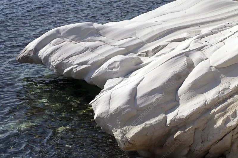

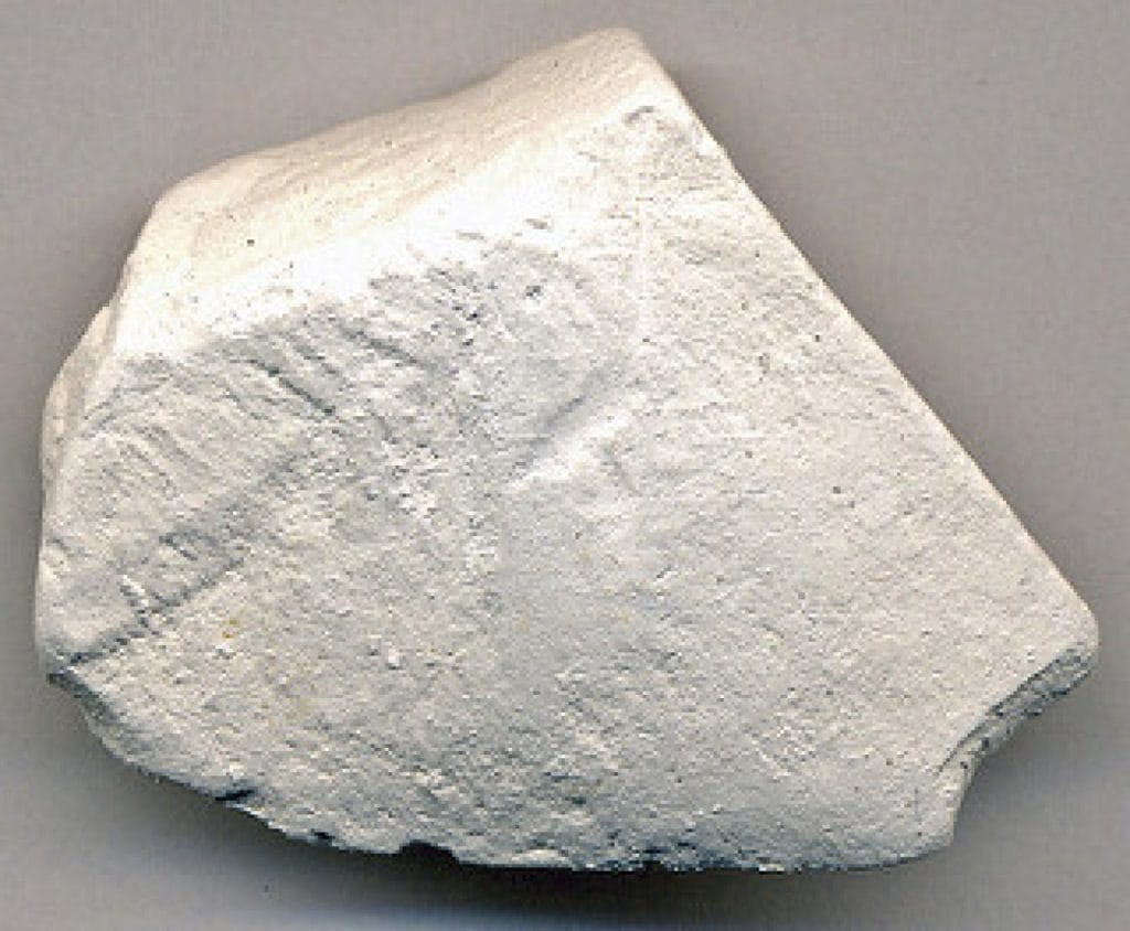


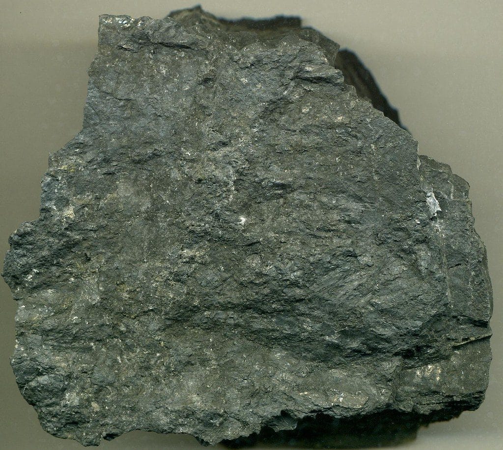


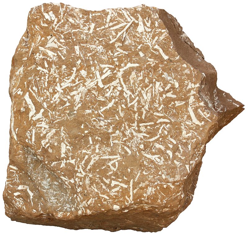
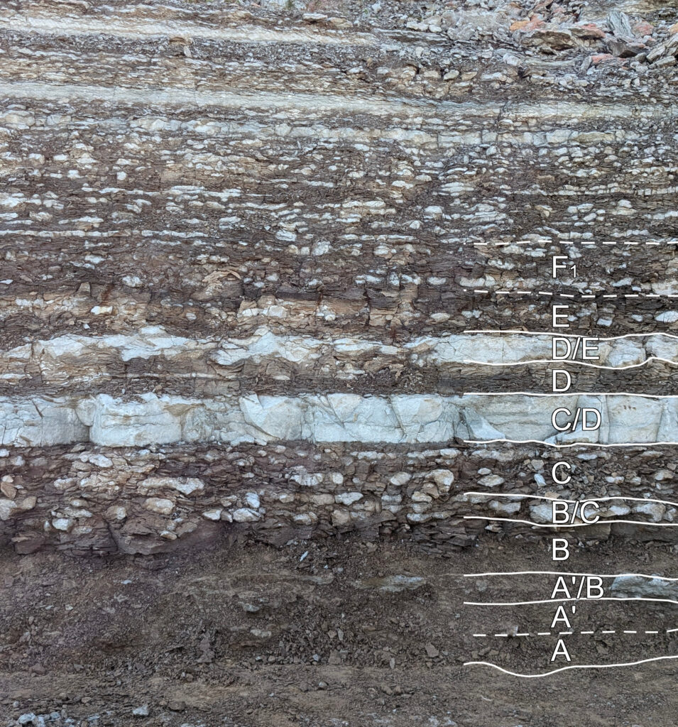

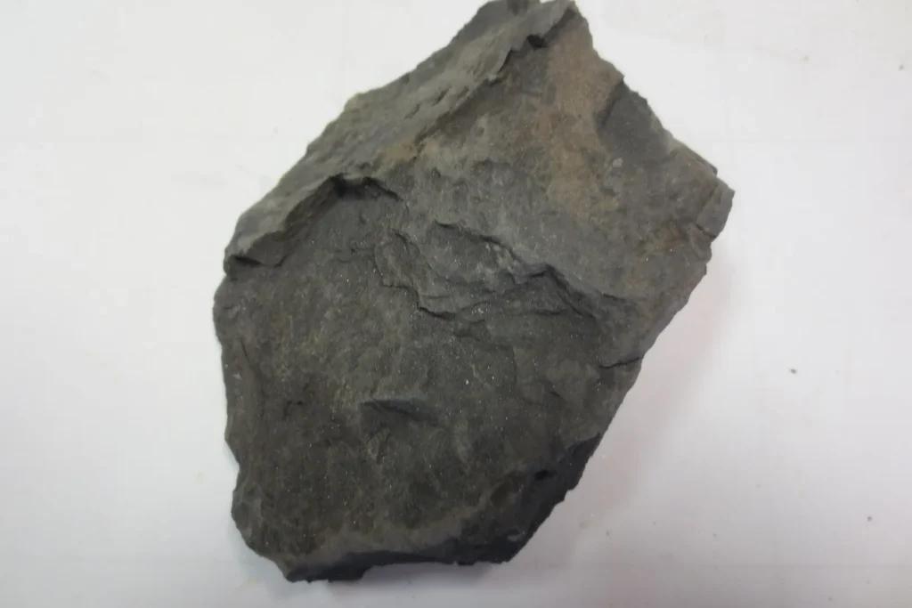
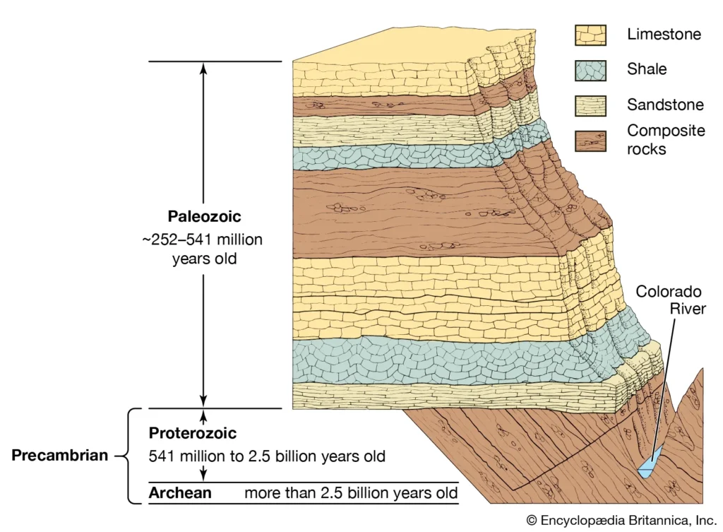
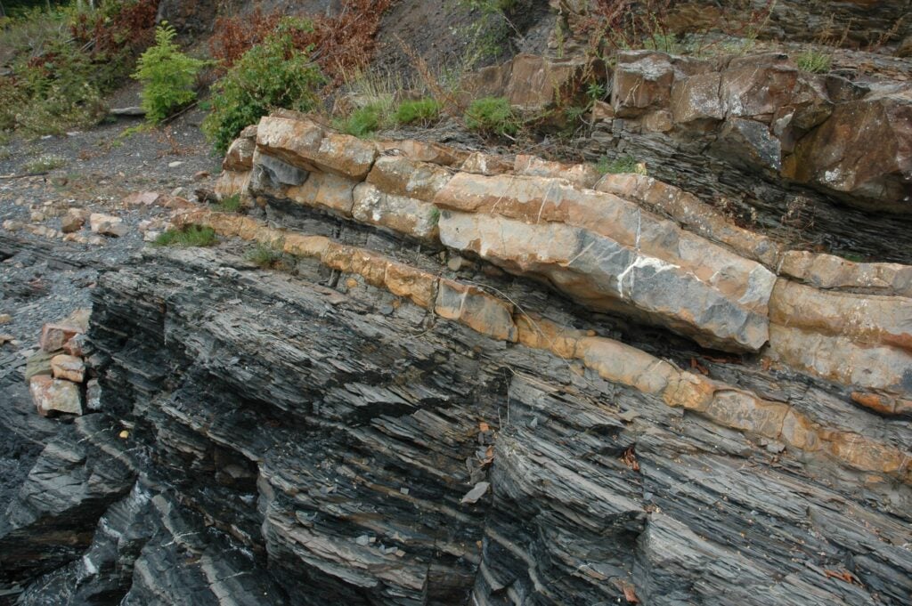
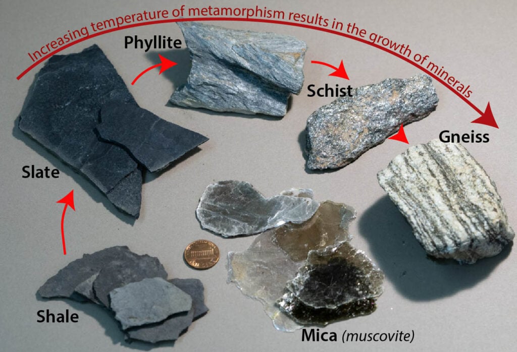
 - Kopya")


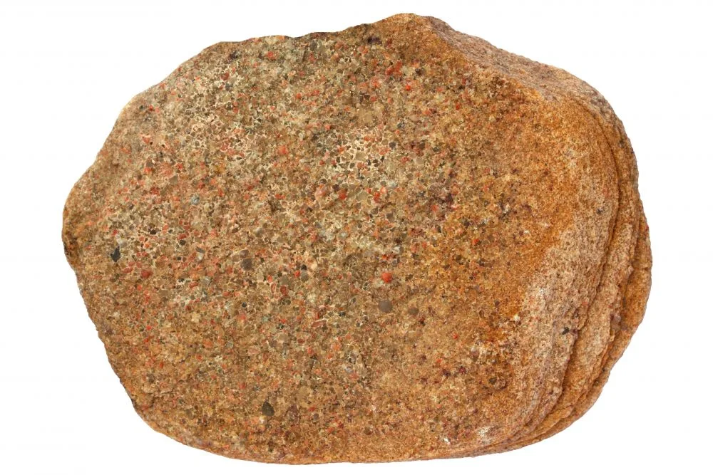
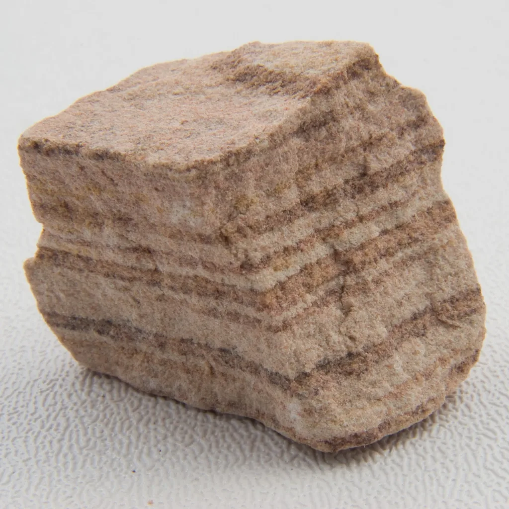
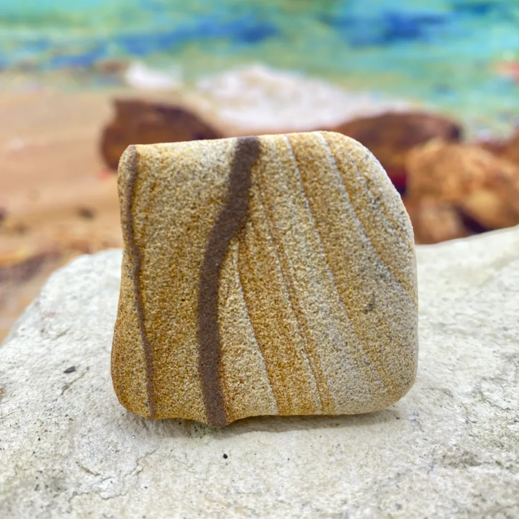
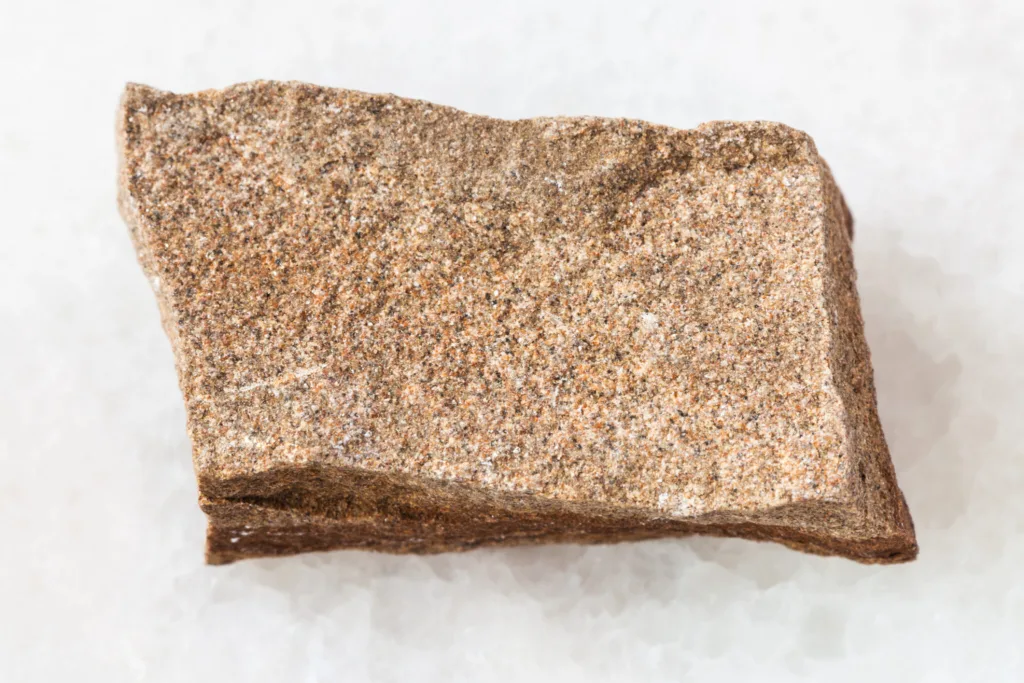
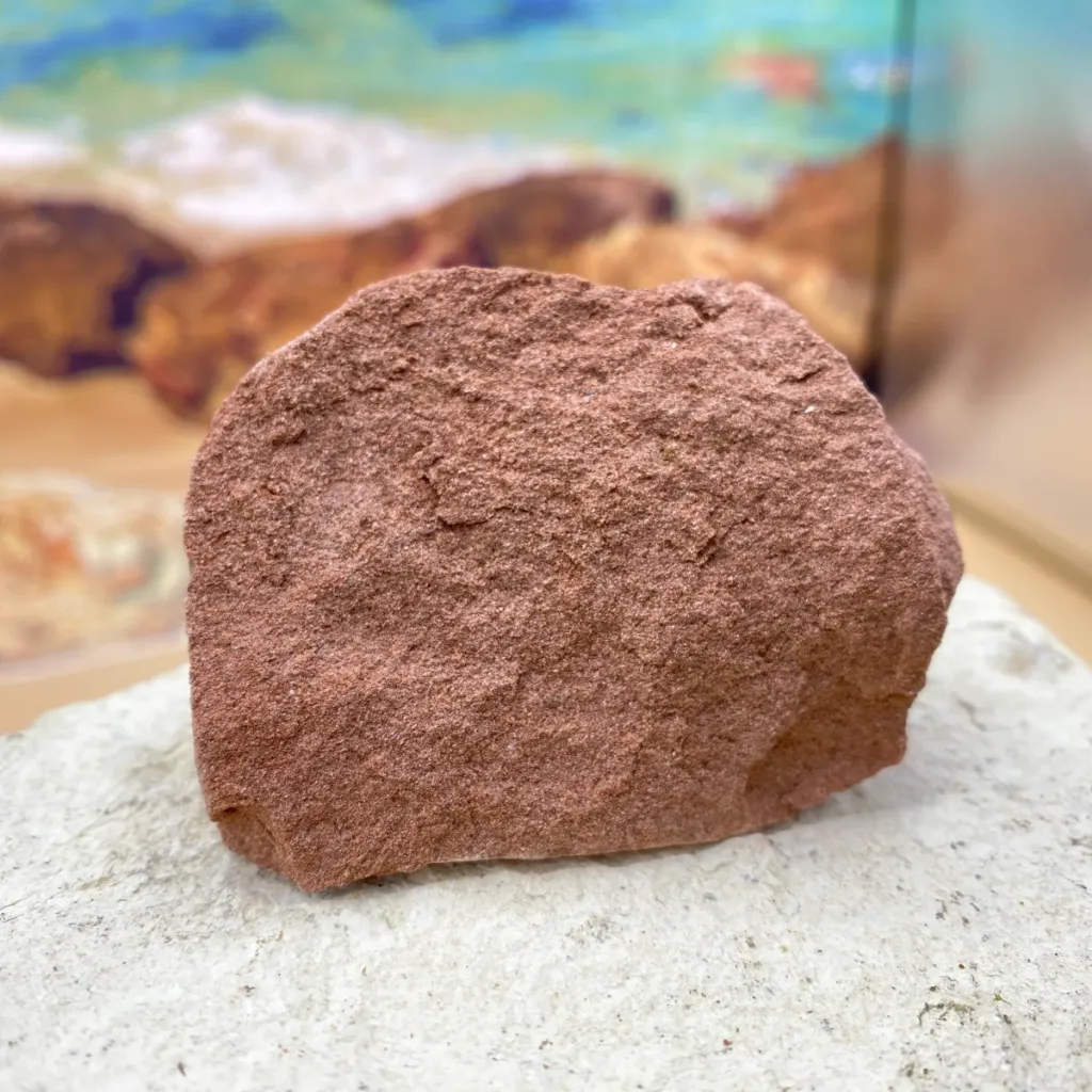

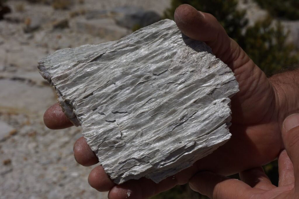
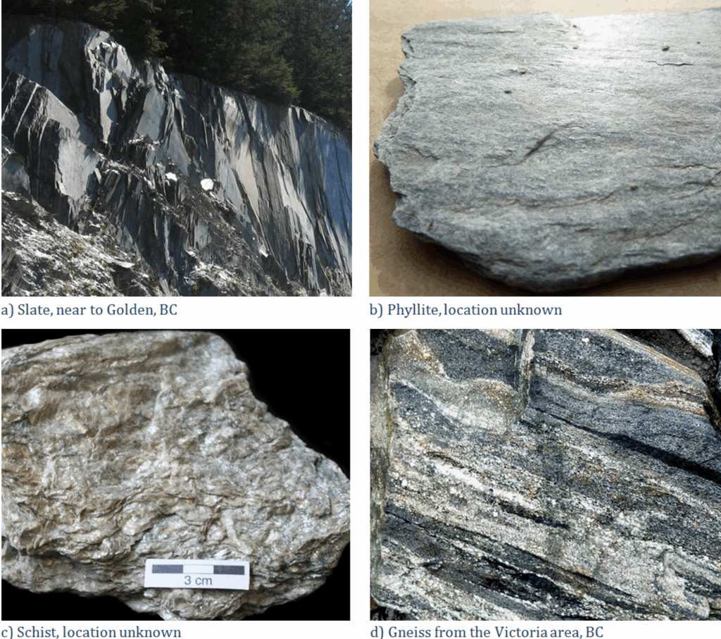

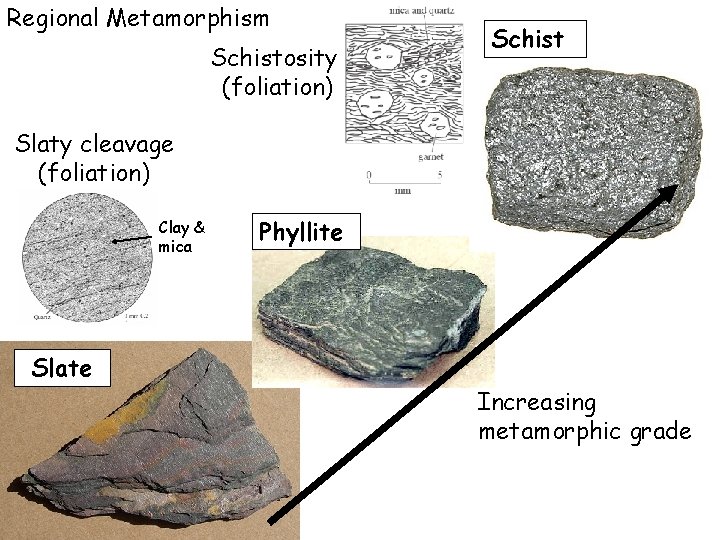
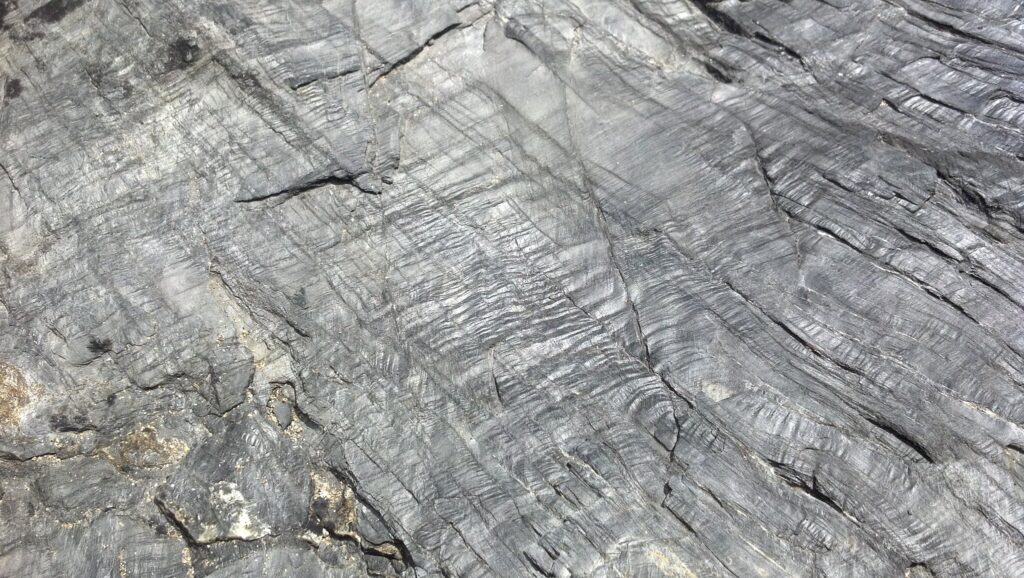


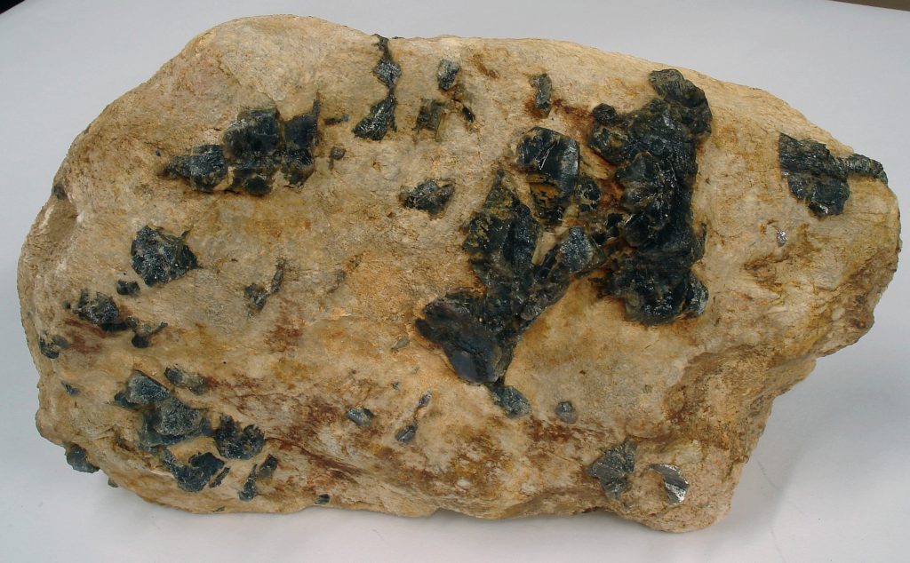
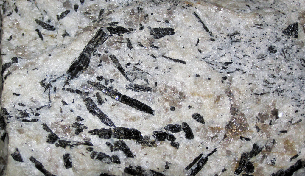

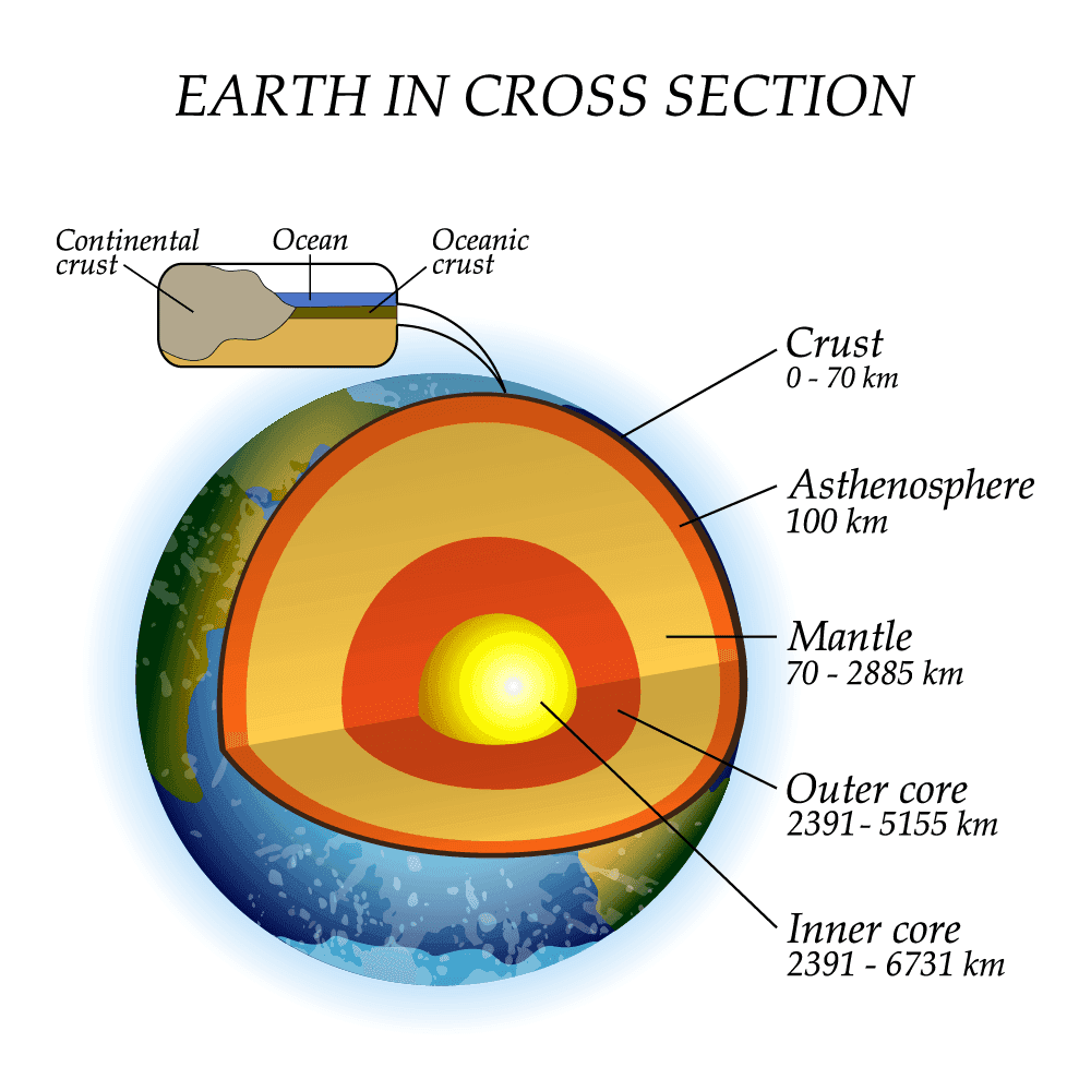
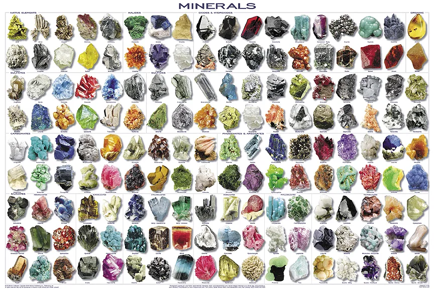
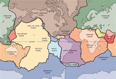
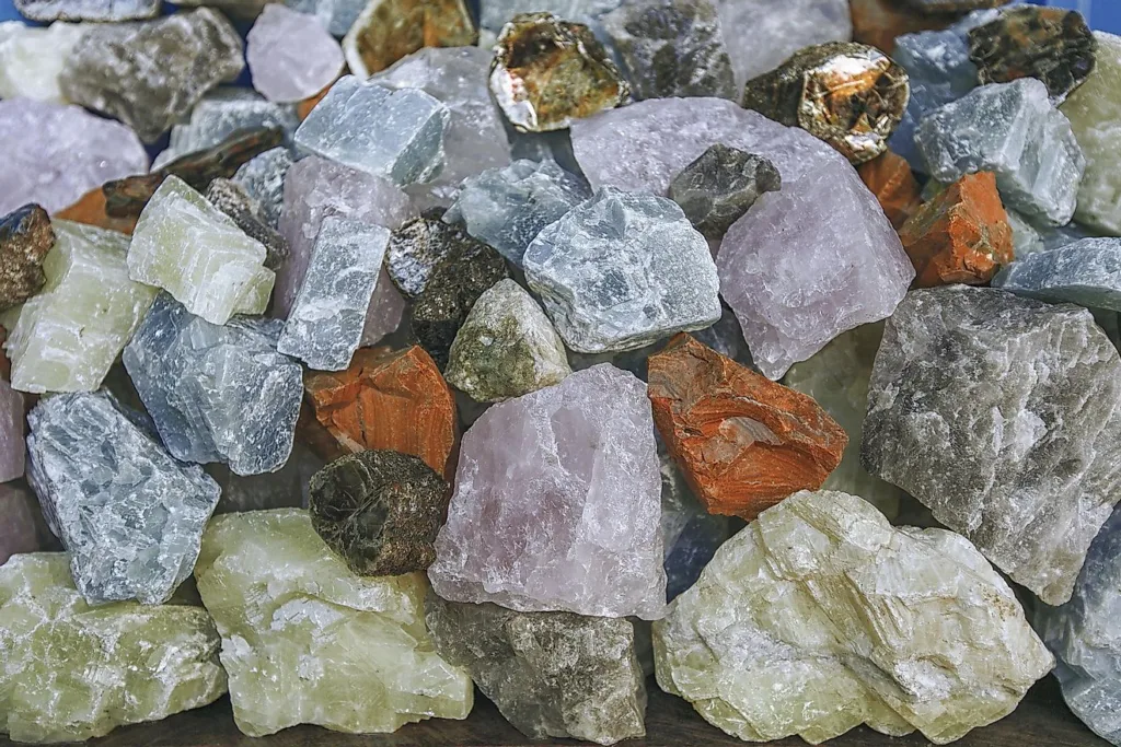
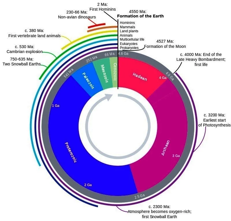
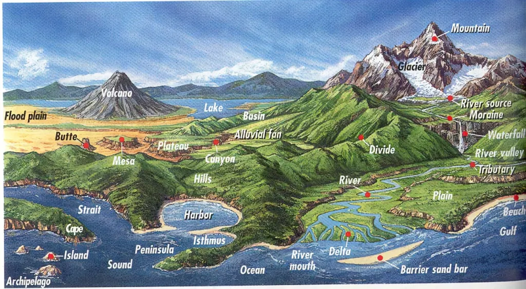
")
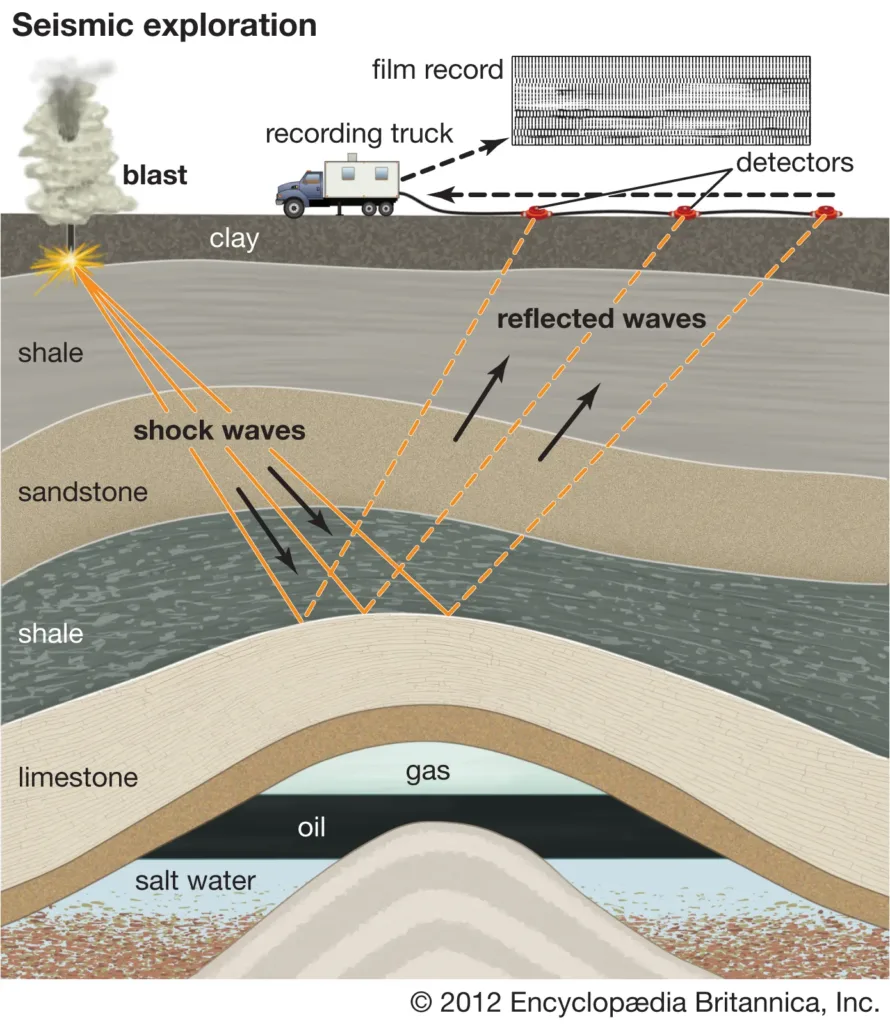


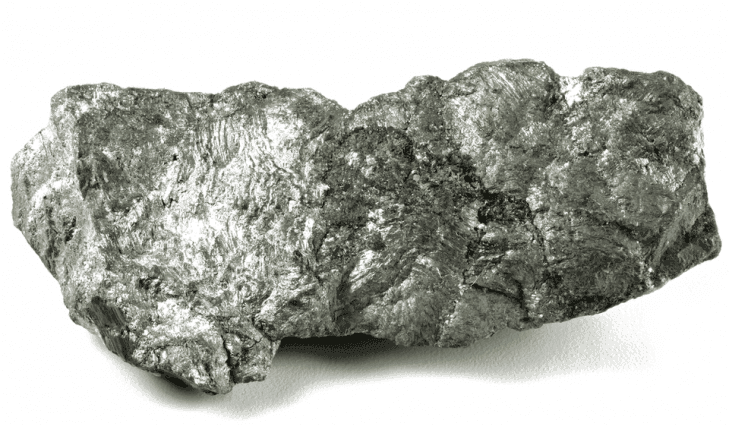
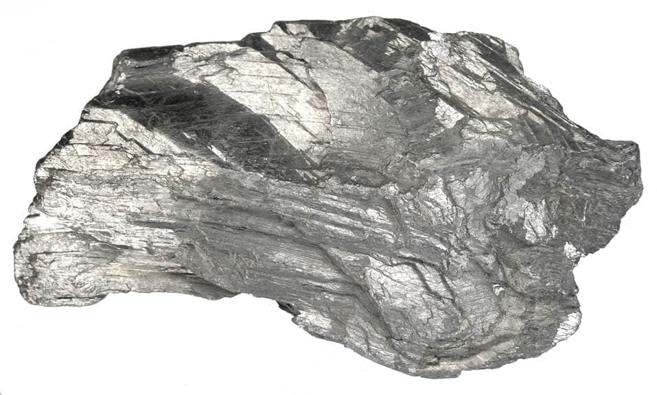
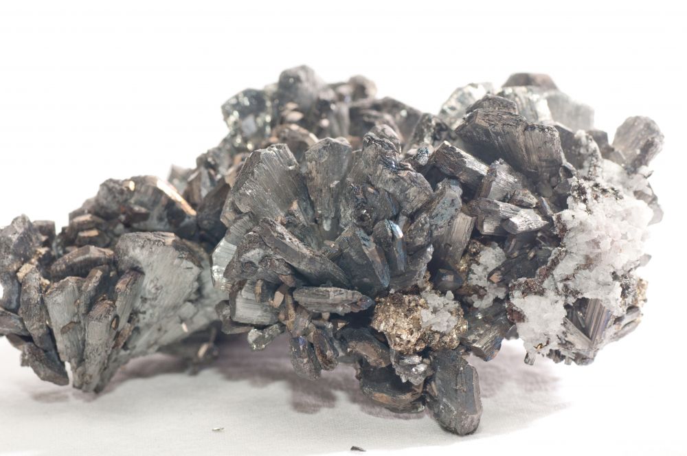
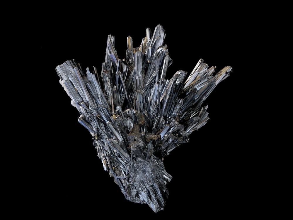

")