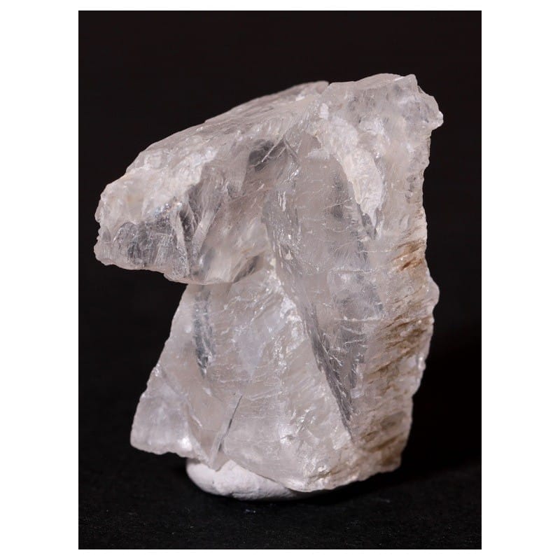
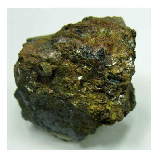
Chalcedony is a mineral that is composed of microscopic crystals of quartz. It is a cryptocrystalline form of silica, meaning that its crystals are too small to be seen without the aid of a microscope. Chalcedony typically has a waxy or glassy luster, and comes in a range of colors, including white, gray, blue, and brown. It is often used as a gemstone or in jewelry-making, and is also used in the production of various industrial products such as ceramics and abrasives. Chalcedony can be found all over the world, and is commonly found in volcanic rocks, geodes, and in sedimentary rocks.
Importance of chalcedony in various fields
Chalcedony has a wide range of uses in various fields, including:
Jewelry-making: Chalcedony is a popular gemstone used in jewelry-making due to its attractive colors, durability, and affordability. It can be cut and polished into various shapes and sizes, and is often used in pendants, earrings, and bracelets.
Industrial applications: Chalcedony is used in the production of various industrial products, including ceramics, abrasive materials, and polishing agents. It is also used in the manufacture of ultrasonic transducers, which are used in medical and industrial imaging.
Geology: Chalcedony is an important mineral in geology, as it is commonly found in sedimentary rocks and can provide clues about the history of the Earth’s formation.
Overall, chalcedony has many practical and aesthetic uses, and its versatility and abundance make it an important mineral in various fields.
Formation of Chalcedony
Chalcedony forms through the precipitation of silica in water-rich environments. The process typically begins with the dissolution of silica-rich minerals, such as quartz, in water. As the water becomes saturated with dissolved silica, it can deposit the silica in cavities and fractures in rocks, or in other spaces such as geodes.
Once the silica is deposited, it can form microcrystalline structures that make up chalcedony. These structures are formed through a process of nucleation and crystal growth, where individual silica molecules come together to form small crystals, which then grow and join together to form larger structures.
The specific conditions of the environment in which the chalcedony forms can affect its color, texture, and other properties. For example, chalcedony that forms in volcanic rocks can have a banded appearance due to the presence of other minerals, while chalcedony that forms in sedimentary rocks can have a more uniform appearance.
Overall, chalcedony formation is a complex process that can involve many different factors, including the presence of other minerals, temperature, pressure, and the composition of the surrounding rock and water.
Factors that affect chalcedony formation
Several factors can affect the formation of chalcedony, including:
Presence of silica-rich minerals: Chalcedony forms from the precipitation of dissolved silica in water. The presence of silica-rich minerals, such as quartz or chert, in the surrounding rock can provide a source of dissolved silica for chalcedony formation.
Water chemistry: The chemistry of the water in which chalcedony forms can affect its color and texture. For example, chalcedony that forms in acidic water may have a yellow or orange color, while chalcedony that forms in alkaline water may have a blue or gray color.
Temperature and pressure: Chalcedony formation can be influenced by the temperature and pressure of the environment in which it forms. Higher temperatures and pressures can lead to larger crystal structures, while lower temperatures and pressures can result in smaller structures.
Time: Chalcedony formation is a slow process that can take thousands or even millions of years. The longer the process takes, the larger the crystals can grow and the more complex the texture can become.
Presence of other minerals: The presence of other minerals, such as iron oxides or manganese oxides, can affect the color and texture of chalcedony. For example, the presence of iron can give chalcedony a reddish-brown color, while the presence of manganese can give it a pink or purple hue.
Overall, the formation of chalcedony is a complex process that can be influenced by many different factors. The specific conditions of the environment in which it forms can affect its color, texture, and other properties, making each piece of chalcedony unique.
Occurrence of Chalcedony
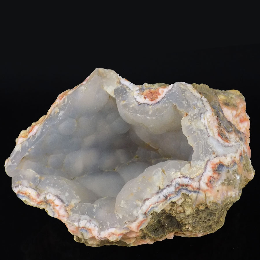
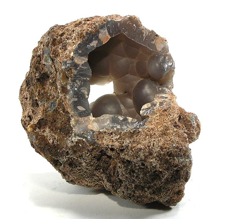
Chalcedony can occur in a variety of environments, including sedimentary, igneous, and metamorphic rocks. It can also be found in geodes, as well as in mineral veins and cavities.
Sedimentary rocks: Chalcedony can be found in sedimentary rocks such as limestone, shale, and sandstone. It often forms in the cavities and fractures of these rocks, and can have a banded or layered appearance.
Igneous rocks: Chalcedony can also occur in igneous rocks such as lava and volcanic ash. When magma cools and solidifies, it can create cavities that become filled with chalcedony.
Metamorphic rocks: Chalcedony can be found in metamorphic rocks such as schist and gneiss. These rocks are formed from the alteration of preexisting rocks due to high heat and pressure, and chalcedony can form in the fractures and cavities created during this process.
Geodes: Geodes are spherical rocks that contain cavities lined with crystals. Chalcedony can form inside these cavities, often with other minerals such as quartz or calcite.
Mineral veins and cavities: Chalcedony can be found in mineral veins and cavities that form in rocks due to the deposition of minerals from fluids. It can occur in a variety of colors and textures depending on the specific conditions of the environment.
Chalcedony is found all over the world and is a very common mineral. Some notable sources of chalcedony include Brazil, Madagascar, Mexico, and the United States.
Global distribution of chalcedony
Chalcedony is a very common mineral found all over the world. It can be found in a variety of geological environments, including sedimentary, igneous, and metamorphic rocks, as well as in geodes and mineral veins.
Some notable sources of chalcedony include:
Brazil: Brazil is a major producer of chalcedony, with large deposits found in the states of Minas Gerais, Rio Grande do Sul, and Bahia. The chalcedony from Brazil is often colored and banded, and is highly prized by gemstone collectors and jewelry makers.
Madagascar: Madagascar is another major producer of chalcedony, with large deposits found in the southern part of the island. The chalcedony from Madagascar is often translucent and can be found in a variety of colors, including blue, green, and pink.
Mexico: Mexico is known for its deposits of fire agate, a type of chalcedony with a fiery, iridescent appearance. The fire agate is found in the state of Chihuahua and is highly prized by gemstone collectors.
United States: Chalcedony is found in many parts of the United States, including California, Oregon, and Nevada. In California, chalcedony can be found in the Big Sur region, while in Oregon it is found in the Owyhee Mountains. The chalcedony from these areas is often banded and colored, and is used in jewelry making and lapidary work.
Overall, chalcedony is a widespread mineral found in many parts of the world. Its occurrence and properties can vary depending on the specific geological environment in which it forms.
Geological formations where chalcedony is commonly found
Chalcedony is a mineral that can be found in a variety of geological formations, including sedimentary, igneous, and metamorphic rocks, as well as in mineral veins and geodes. Some common geological formations where chalcedony is found include:
Limestone: Chalcedony is commonly found in the cavities and fractures of limestone rocks. These cavities can be filled with banded, nodular, or botryoidal chalcedony.
Volcanic rocks: Chalcedony can also occur in volcanic rocks such as basalt, rhyolite, and obsidian. It often forms in cavities and voids created by gas bubbles in the lava, and can be found in a variety of colors and textures.
Shale: Chalcedony can occur in the fractures and cavities of shale, often in the form of banded agate or chert.
Geodes: Geodes are spherical rocks that contain cavities lined with crystals. Chalcedony can form inside these cavities, often with other minerals such as quartz or calcite.
Metamorphic rocks: Chalcedony can be found in metamorphic rocks such as schist and gneiss. These rocks are formed from the alteration of preexisting rocks due to high heat and pressure, and chalcedony can form in the fractures and cavities created during this process.
Mineral veins: Chalcedony can occur in mineral veins that form in rocks due to the deposition of minerals from fluids. It can occur in a variety of colors and textures depending on the specific conditions of the environment.
Overall, chalcedony is a mineral that can be found in a wide variety of geological formations, and its occurrence and properties can vary depending on the specific environment in which it forms.
Types of rocks associated with chalcedony
Chalcedony can be found in a variety of rock types, including sedimentary, igneous, and metamorphic rocks. Here are some of the specific types of rocks commonly associated with chalcedony:
Limestone: Chalcedony is often found in limestone rocks, particularly in the cavities and fractures within the rock. The chalcedony can be banded or layered, and can range in color from white to gray, brown, and red.
Basalt: Basalt is an igneous rock that can contain chalcedony, particularly in the form of nodules or veins. The chalcedony in basalt can be banded or colored, and can range from translucent to opaque.
Rhyolite: Rhyolite is another igneous rock that can contain chalcedony. The chalcedony in rhyolite can be found in cavities and veins within the rock, and can be banded or colored.
Shale: Chalcedony can also be found in shale rocks, particularly in the fractures and cavities within the rock. The chalcedony in shale can be banded or layered, and can range in color from white to gray, brown, and red.
Schist: Schist is a metamorphic rock that can contain chalcedony, particularly in the form of veins or nodules. The chalcedony in schist can be banded or colored, and can range from translucent to opaque.
Quartzite: Quartzite is another metamorphic rock that can contain chalcedony, particularly in the form of veins or nodules. The chalcedony in quartzite can be banded or colored, and can range from translucent to opaque.
Overall, chalcedony can be found in a variety of rock types, and its occurrence and properties can vary depending on the specific geological environment in which it forms.
Physical Properties of Chalcedony
Chalcedony is a mineral with several distinct physical properties. Here are some of the key characteristics:
Hardness: Chalcedony has a hardness of 6.5-7 on the Mohs scale, which makes it relatively hard and durable.
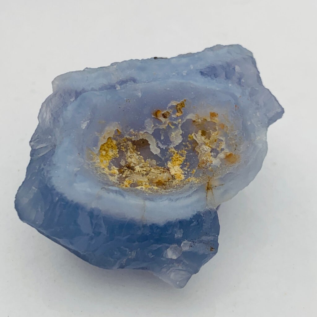
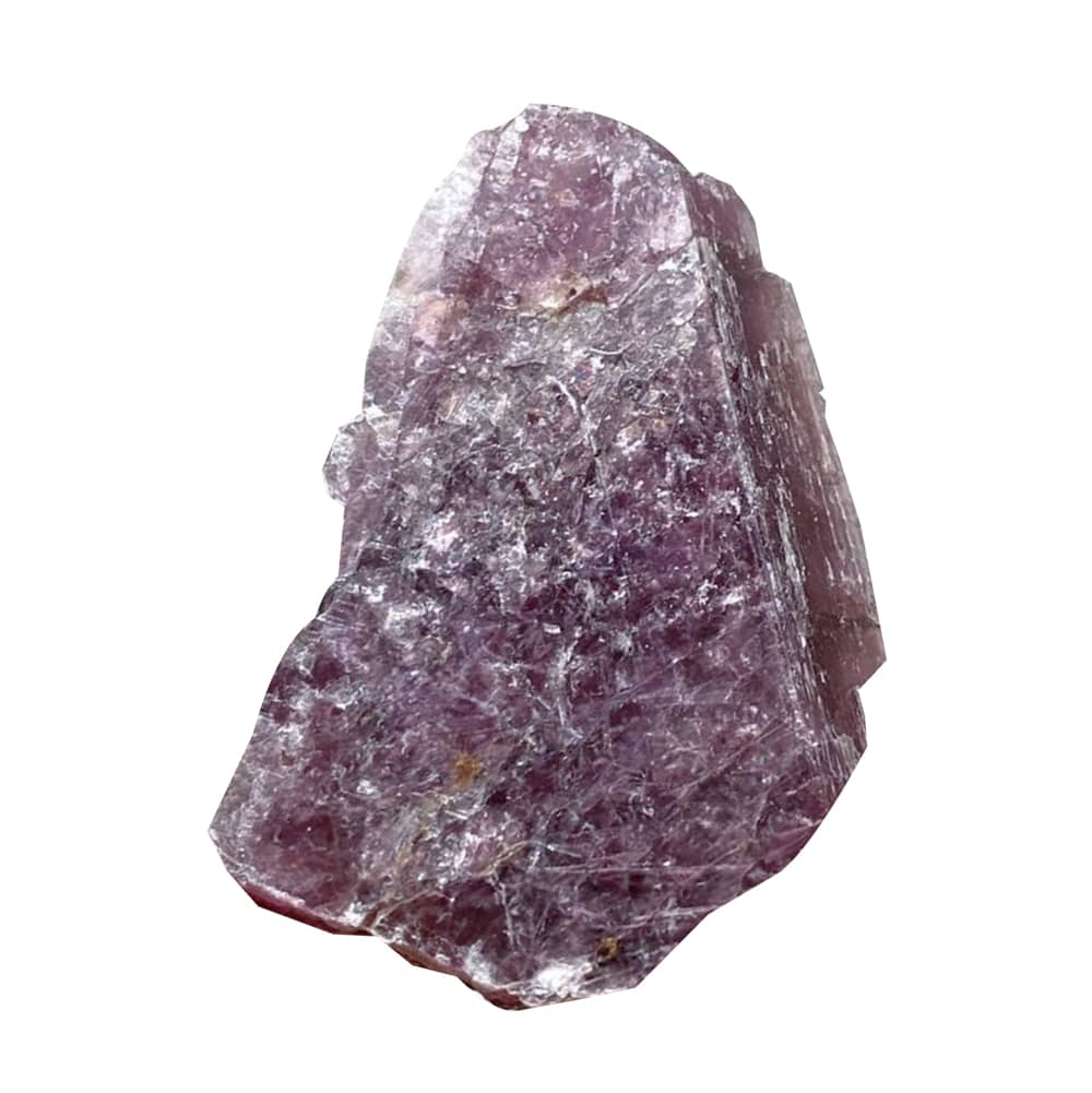
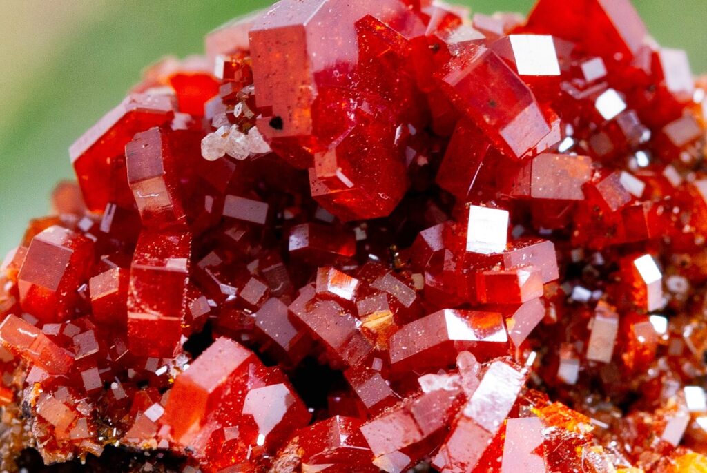
Color: Chalcedony can occur in a wide range of colors, including white, gray, blue, pink, yellow, brown, and red. The color is often consistent within a single specimen, but can also be banded or striped.
Luster: Chalcedony has a waxy to dull luster.
Transparency: Chalcedony is typically translucent to opaque.
Crystal System: Chalcedony does not have a crystal structure, but instead consists of tiny crystals that are packed tightly together.
Fracture: Chalcedony has a conchoidal fracture, which means that it breaks into curved, shell-like pieces.
Specific Gravity: Chalcedony has a specific gravity of 2.6-2.7, which means it is slightly heavier than water.
Cleavage: Chalcedony does not have cleavage, meaning that it does not break along specific planes.
Streak: The streak of chalcedony is typically white.
Overall, chalcedony is a versatile mineral with a range of physical properties that make it useful in a variety of applications, including jewelry, ornamental objects, and industrial uses.
Color variations and patterns
Chalcedony can occur in a wide range of colors and patterns, which can make it a popular choice for use in jewelry and decorative objects. Here are some of the most common color variations and patterns of chalcedony:
White: White chalcedony is one of the most common varieties, and is prized for its pure, clean appearance. It can range in transparency from opaque to translucent.
Gray: Gray chalcedony is another popular variety, and can range in color from light gray to dark charcoal. It often has a translucent appearance and may be banded or streaked.
Blue: Blue chalcedony is prized for its beautiful sky-blue color, which can range from pale baby blue to deep turquoise. It is often translucent and may be banded or streaked.
Pink: Pink chalcedony is a delicate, feminine variety that can range in color from pale pink to bright fuchsia. It is often translucent and may be banded or streaked.
Yellow: Yellow chalcedony is a warm, sunny variety that can range in color from pale buttercup to deep mustard. It is often translucent and may be banded or streaked.
Brown: Brown chalcedony is a rich, earthy variety that can range in color from light tan to dark chocolate. It often has a translucent appearance and may be banded or streaked.
Red: Red chalcedony is a vibrant, eye-catching variety that can range in color from pale pink to deep crimson. It is often translucent and may be banded or streaked.
In addition to these color variations, chalcedony can also display a variety of patterns, such as bands, stripes, and swirls. These patterns can be caused by the way the mineral formed or by impurities and other minerals that are present in the rock. The unique patterns and colors of chalcedony make it a popular choice for use in jewelry and decorative objects.
Optical properties of chalcedony
Chalcedony has a number of optical properties that contribute to its unique appearance. Here are some of the key characteristics:
Transparency: Chalcedony can range from opaque to translucent, depending on the particular variety and the presence of impurities.
Refractive Index: The refractive index of chalcedony is relatively low, typically around 1.54-1.55.
Birefringence: Chalcedony is not birefringent, meaning that it does not split light into two separate rays as it passes through the mineral.
Dispersion: Chalcedony has a relatively low dispersion, meaning that it does not separate white light into its component colors to a significant degree.
Pleochroism: Chalcedony does not exhibit pleochroism, meaning that it does not display different colors when viewed from different angles.
Fluorescence: Some varieties of chalcedony may exhibit fluorescence under ultraviolet light.
Overall, chalcedony has a relatively low refractive index and dispersion, which means that it does not produce the same kind of bright, colorful flashes as other gemstones like diamond or sapphire. However, its unique patterns and colors can still make it a desirable choice for use in jewelry and decorative objects.
Chemical Composition of Chalcedony
Chalcedony is a variety of the mineral quartz, which has the chemical formula SiO2. This means that chalcedony is primarily composed of silicon and oxygen, with trace amounts of other elements and minerals.
Chalcedony can contain a variety of impurities, which can give it its distinctive colors and patterns. For example, iron oxide impurities can cause chalcedony to appear yellow or brown, while manganese and titanium can create pink and blue colors, respectively. Other common impurities include aluminum, calcium, and copper.
In addition to these impurities, chalcedony may also contain tiny inclusions or cavities that can affect its appearance and properties. For example, some chalcedony may contain small inclusions of minerals like goethite, hematite, or pyrite, which can create interesting patterns and textures within the stone.
Overall, the chemical composition of chalcedony is relatively simple, but its unique impurities and inclusions can give it a wide range of colors and patterns that make it a popular choice for use in jewelry and decorative objects.
Differences between chalcedony and other forms of silica
Chalcedony is one of several forms of silica, which is a mineral composed of silicon and oxygen. Here are some of the key differences between chalcedony and other forms of silica:
Quartz: Quartz is the most common form of silica, and is closely related to chalcedony. Both minerals have the same chemical formula (SiO2), but chalcedony has a more compact and microcrystalline structure than quartz, which has a crystalline structure.
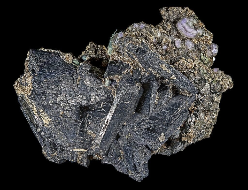
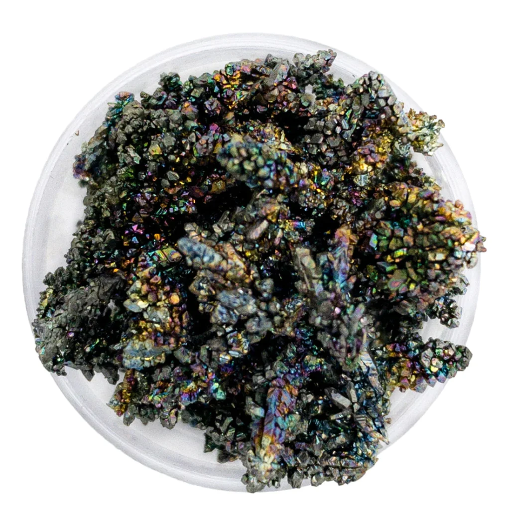
Agate: Agate is a type of chalcedony that is characterized by its distinctive banding patterns. Agate forms in cavities within volcanic rocks, and its banding is caused by the deposition of different minerals and impurities over time. While chalcedony can occur in a wide range of colors and patterns, agate is typically banded or striped.
Jasper: Jasper is another type of chalcedony, but it is typically opaque and has a more earthy appearance than other varieties. Jasper can occur in a wide range of colors, including red, brown, yellow, and green, and often has interesting patterns and markings.
Opal: Opal is a hydrated form of silica, meaning that it contains water molecules in addition to silicon and oxygen. Unlike chalcedony, opal is amorphous, meaning that it lacks a crystalline structure. Opal is prized for its iridescent colors and unique patterns.
Cristobalite and Tridymite: Cristobalite and tridymite are two other forms of silica that have different crystal structures than chalcedony and quartz. Cristobalite and tridymite are typically formed at high temperatures and pressures, and are found in volcanic rocks and other igneous formations.
Overall, while chalcedony shares some similarities with other forms of silica, its microcrystalline structure and distinctive colors and patterns set it apart from other minerals in the quartz family.
Industrial and Decorative Uses of Chalcedony
Chalcedony has a variety of industrial and decorative uses, thanks to its unique properties and appearance. Here are some of the most common uses of chalcedony:
Jewelry: Chalcedony is a popular gemstone that is often used in jewelry making. Its distinctive colors and patterns make it a favorite among designers and collectors, and it is often cut into beads, cabochons, and other shapes.
Carvings and Sculptures: Chalcedony’s hardness and durability make it an ideal material for carvings and sculptures. It has been used for decorative objects and figurines for centuries, and its wide range of colors and patterns make it a versatile material for artistic expression.
Industrial Applications: Chalcedony’s hardness and durability make it useful in a variety of industrial applications. It is often used as an abrasive material in polishing and grinding, and is also used in the production of glass and ceramics.
Ornamental Uses: Chalcedony’s unique colors and patterns make it a popular choice for use in decorative objects such as vases, bookends, and other ornamental pieces.
Overall, chalcedony’s versatility and beauty make it a valuable mineral for a variety of different applications, from jewelry making to industrial processes. Its unique properties and appearance have made it a popular choice for artists, designers, and craftsmen throughout history.
Summary of key points about chalcedony’s geology
Here are the key points about chalcedony’s geology:
Chalcedony is a microcrystalline form of silica, composed of silicon dioxide (SiO2).
It forms in a variety of geological settings, including volcanic rocks, sedimentary rocks, and hydrothermal veins.
Chalcedony forms when silica-rich water percolates through rocks and deposits tiny silica particles in cavities and fractures.
It can occur in a variety of colors and patterns, depending on the impurities and minerals present in the deposit.
Chalcedony is often found in association with other minerals, such as quartz, calcite, and pyrite.
The most common forms of chalcedony include agate, jasper, and onyx.
Chalcedony is widely distributed around the world, with major deposits found in regions such as Brazil, Madagascar, and the western United States.
The physical and chemical properties of chalcedony can vary depending on the location and conditions of its formation.
Overall, chalcedony’s geology is complex and varied, with the mineral forming in a wide range of geological settings and exhibiting a variety of different colors and patterns.
Chalcedony FAQ
What is chalcedony?
Chalcedony is a microcrystalline form of silica, composed of silicon dioxide (SiO2). It is a mineral that is found in a variety of colors and patterns and is often used in jewelry making, decorative objects, and industrial applications.
What is the difference between chalcedony and quartz?
Chalcedony and quartz are both forms of silica, but they have different crystal structures. Quartz has a crystal structure that is characterized by a six-sided prism with six-sided pyramids at each end, while chalcedony has a fibrous or microcrystalline structure.
What are the different types of chalcedony?
The most common types of chalcedony include agate, jasper, and onyx. Other types include carnelian, bloodstone, and chrysoprase.
Where is chalcedony found?
Chalcedony is found worldwide, but some of the largest deposits are found in Brazil, Madagascar, and the western United States. It is often found in association with other minerals, such as quartz, calcite, and pyrite.
What is chalcedony used for?
Chalcedony is used in a variety of ways, including jewelry making, decorative objects, carvings, sculptures, industrial applications, and alternative medicine practices. It is prized for its unique colors and patterns, as well as its hardness and durability.
Is chalcedony a valuable mineral?
The value of chalcedony depends on a variety of factors, such as its color, pattern, and rarity. Some types of chalcedony, such as rare or unusual specimens, can be quite valuable to collectors and jewelry makers.
What is the difference between chalcedony and agate?
Agate is a type of chalcedony that has distinct banding patterns. It is formed when layers of chalcedony deposit in concentric circles, creating a banded appearance. Other types of chalcedony may not exhibit this banding pattern.
References
Deer, W. A., Howie, R. A., & Zussman, J. (2013). An introduction to the rock-forming minerals. Mineralogical Society of Great Britain and Ireland.
Heaney, P. J. (1994). Silica minerals. In Reviews in Mineralogy and Geochemistry (Vol. 29, pp. 1-62). Mineralogical Society of America.
Pough, F. H., Peterson, F. L., & Goodwin, D. W. (1998). A field guide to rocks and minerals. Houghton Mifflin Harcourt.
Schumann, W. (2008). Gemstones of the world (5th ed.). Sterling Publishing Co., Inc.
Smith, J. V., & Brown, W. L. (1988). Feldspar minerals: Crystal structure and physical properties. Springer-Verlag.
Whitney, D. L., & Evans, B. W. (2010). Abbreviations for names of rock-forming minerals. American Mineralogist, 95(1), 185-187.
A geyser is a natural phenomenon that consists of a hot spring that periodically erupts, sending a column of hot water and steam into the air. Geysers are rare and are typically found in geothermal areas with specific geological and hydrological conditions. They are most commonly associated with volcanic regions and areas with high levels of geothermal activity, such as Iceland, Yellowstone National Park in the United States, and the North Island of New Zealand.
Geysers form when water is heated by geothermal heat from the Earth’s interior, typically from magma or hot rocks beneath the surface. The heated water rises through conduits or channels in the ground, and as pressure builds up, it eventually erupts in a powerful burst, shooting water and steam into the air. The eruptions are often accompanied by a characteristic column of steam and can vary in height, frequency, and duration depending on the specific geyser.
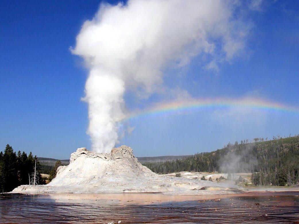
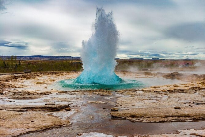
Yellostone Geyser
Geysers can have different shapes and sizes, with some forming small bubbling pools and others forming large, towering eruptions reaching tens of meters in height. Some of the most famous geysers, such as Old Faithful in Yellowstone National Park, erupt with remarkable regularity, making them popular tourist attractions.
Geysers are unique natural wonders that offer insights into the Earth’s geothermal processes and are often regarded as symbols of the power and beauty of nature. However, they are delicate features that can be sensitive to changes in hydrological or geological conditions, and their formation and behavior can evolve over time. Proper conservation and management are necessary to protect and preserve these natural wonders for future generations to enjoy.
Geyser: Haukadalsvegur, Geysir
Importance of geysers in geology and geothermal systems
Geysers are significant features in geology and geothermal systems due to several reasons:
Indicators of geothermal activity: Geysers are clear indicators of geothermal activity, which is the heat generated by the Earth’s internal processes. They often occur in areas with volcanic or geologically active landscapes, and their presence can signal the presence of geothermal reservoirs, where hot water and steam are stored in underground rock formations. By studying geysers, geologists can gain insights into the location, size, and behavior of these geothermal reservoirs, which can have practical applications for geothermal energy exploration and development.
Hydrothermal processes: Geysers are formed by hydrothermal processes, which involve the interaction of water with heated rocks and minerals. These processes can alter the composition and structure of rocks, creating unique hydrothermal features and mineral deposits. Studying geysers can provide valuable information about these hydrothermal processes, including how they affect the surrounding geology, the types of minerals that form, and the conditions under which they occur. This knowledge can have implications for understanding ore deposits, geothermal systems, and other geological phenomena.
Understanding geothermal fluid dynamics: Geysers are driven by the dynamics of geothermal fluids, which involve the movement of hot water and steam through underground conduits and channels. The eruptions of geysers are controlled by a complex interplay of factors, including the temperature, pressure, and chemistry of the geothermal fluids, as well as the characteristics of the conduit systems. By studying geysers, scientists can gain insights into the behavior and properties of geothermal fluids, which can improve our understanding of fluid dynamics in geothermal systems and other subsurface environments.
Environmental and ecological significance: Geysers and their surrounding areas often support unique and fragile ecosystems that are adapted to the extreme conditions of high heat and mineral-rich waters. These ecosystems can provide valuable insights into how life can thrive in extreme environments and contribute to our understanding of astrobiology and the potential for life on other planets. Additionally, geysers and their surroundings are often protected areas with high ecological and cultural value, and proper management and conservation of these areas are crucial for preserving their biodiversity, cultural heritage, and recreational value.
In summary, geysers play an important role in geology and geothermal systems by serving as indicators of geothermal activity, providing insights into hydrothermal processes, enhancing our understanding of geothermal fluid dynamics, and contributing to environmental and ecological studies. They are unique natural features that offer valuable scientific, educational, and cultural significance, and their conservation and management are essential for their continued scientific and societal value.
Geological Setting of Geysers
The geological setting of geysers is closely tied to the presence of geothermal activity, which involves the transfer of heat from the Earth’s interior to the surface. Geysers are typically found in areas with specific geological characteristics that allow for the accumulation of heat and the formation of underground reservoirs of hot water and steam. The key geological components that contribute to the formation of geysers include:
Volcanic or geologically active areas: Geysers are commonly associated with volcanic regions or areas with high levels of geothermal activity. Volcanic activity provides a heat source for geysers, as magma and hot rocks beneath the Earth’s surface can heat groundwater, creating a geothermal reservoir. The heat from volcanic activity can also create fractures, fissures, and conduits in the rock formations, which allow for the movement of hot water and steam to the surface and the eventual eruption of a geyser.
Permeable rock formations: Geysers require permeable rock formations that allow water to circulate and accumulate underground. Permeable rocks, such as fractured and porous volcanic rocks or sedimentary formations like sandstone, can act as conduits for the movement of water and steam, allowing them to reach the surface and form geysers. These rock formations often have distinct layers of different types of rocks, which can influence the behavior and characteristics of geysers.
Underground water supply: Geysers require a continuous supply of water from underground to sustain their eruptions. This typically comes from precipitation, which seeps into the ground and percolates through the permeable rock formations. The water then encounters the heat from the geothermal source, causing it to heat up and accumulate in underground reservoirs. Over time, pressure builds up as more water accumulates, leading to the eventual eruption of the geyser.
Confined aquifers: Geysers are often associated with confined aquifers, which are underground water-bearing formations that are under pressure. Confined aquifers are typically located between impermeable layers of rock or clay, which trap the water and create pressure within the aquifer. This pressure can be released through fractures or conduits, leading to the periodic eruptions of geysers.
Hydrothermal features: Geysers are part of a larger hydrothermal system that includes other geothermal features such as hot springs, fumaroles (steam vents), mud pots, and geothermal pools. These features are often found in close proximity to geysers and are indicative of the same underlying geothermal processes. They can provide additional clues about the geological setting of geysers and the characteristics of the geothermal system.
The combination of volcanic or geologically active areas, permeable rock formations, underground water supply, confined aquifers, and other hydrothermal features create the ideal geological setting for the formation of geysers. However, geysers are rare and require specific geological and hydrological conditions to form and sustain their eruptions, making them unique and fascinating natural wonders.
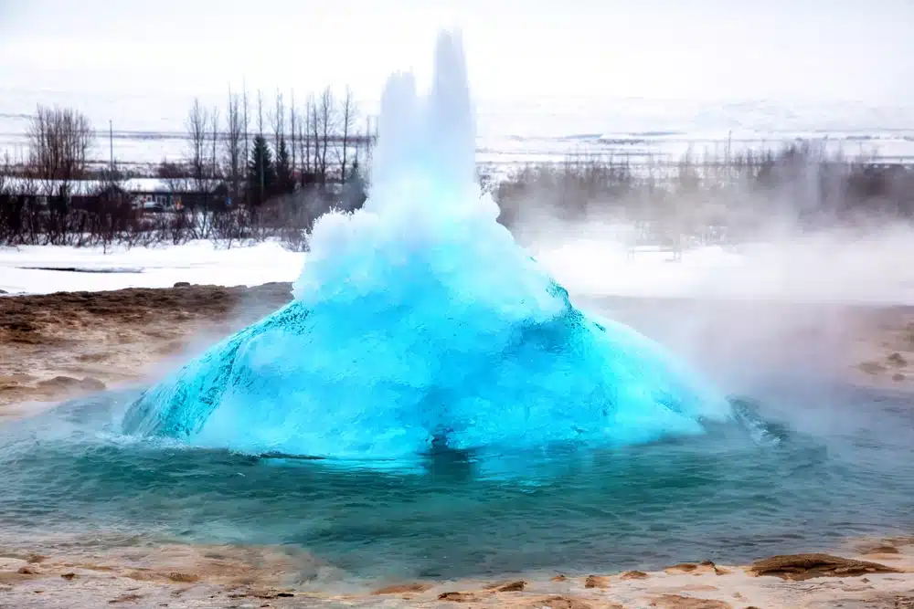
Strokkur – The Overactive Blue Bubble
Formation and Operation of Geysers
The formation and operation of geysers involve a complex interplay of geology, hydrogeology, and thermodynamics. Geysers are formed and sustained by a combination of heat, water, and underground conduits that allow for the periodic eruptions of hot water and steam. The general process of geyser formation and operation can be summarized in the following steps:
Heat Source: Geysers require a heat source to heat the water and create the pressure necessary for eruptions. This heat typically comes from volcanic activity or other geothermal processes, where hot rocks or magma heat the surrounding groundwater. The heat source provides the energy needed to drive the geyser eruption.
Underground Reservoir: As the groundwater is heated by the heat source, it accumulates in underground reservoirs. These reservoirs are typically located in permeable rock formations, such as fractured volcanic rocks or sedimentary formations, where water can circulate and accumulate. The water in the reservoir becomes superheated, reaching temperatures above its boiling point but remaining in a liquid state due to the high pressure.
Conduit System: Geysers require a conduit system that allows the water and steam to rise from the underground reservoir to the surface. This conduit system typically consists of narrow channels or pipes within the rock formations that connect the underground reservoir to the surface. Over time, these conduits can become partially blocked by mineral deposits or debris, creating pressure buildup in the underground reservoir.
Eruption Cycle: When the pressure in the underground reservoir becomes high enough, it overcomes the resistance in the conduit system, causing an eruption. The eruption typically starts with a sudden release of steam and water, followed by a period of intense boiling and splashing. The eruption can last from a few minutes to several hours, depending on the size and characteristics of the geyser. Once the eruption is over, the geyser goes into a period of rest, and the process begins again with the accumulation of water in the underground reservoir and the gradual buildup of pressure.
Recharge Phase: After the eruption, the underground reservoir needs to be replenished with water for the next cycle. This occurs during the recharge phase, where water from precipitation or other sources replenishes the underground reservoir. The recharge phase can last for hours to days or even longer, depending on the size and characteristics of the geyser and the availability of water.
The formation and operation of geysers are complex and dynamic processes that are influenced by various geological, hydrogeological, and thermodynamic factors. The unique combination of heat, water, and underground conduits creates the ideal conditions for geysers to form and operate, resulting in the spectacular eruptions that are characteristic of these natural wonders.
Types and Characteristics of Geysers
Geysers can be classified into different types based on their eruptive characteristics and the nature of their eruptions. Here are some of the common types of geysers:
Cone Geysers: These geysers have a cone-shaped mound of mineral deposits, usually silica, that forms around the vent where the eruptions occur. The cone is built up over time as mineral-rich water is sprayed out during eruptions and then solidifies upon contact with air. Cone geysers tend to have frequent, shorter eruptions, and the cone shape can vary in size and shape depending on the specific geyser.
Fountain Geysers: These geysers erupt with a tall, vertical column of water and steam that is typically not accompanied by a pronounced cone formation. Fountain geysers have eruptions that are more like a continuous fountain or gush of water rather than a periodic eruption with distinct resting phases. They often have a more irregular eruption pattern compared to cone geysers.
Fountain Paint Pot Geysers: These geysers are characterized by their thick, pasty mud-like eruptions, which are a mix of water, steam, and clay or silica-rich mud. The eruptions are typically not as tall or forceful as cone or fountain geysers, but they can be visually interesting due to the mud-like consistency of the eruptions.
Steam Geysers: These geysers primarily erupt with steam rather than water, and they may not have a visible water column during eruptions. Steam geysers are typically found in areas where the water supply to the geyser is limited, or the underground conduit system is partially blocked, allowing only steam to escape during eruptions.
Geyserettes: These are smaller geysers that have relatively low eruptions and may not have a pronounced cone or vent structure. Geyserettes are often associated with larger geysers and are considered as “baby geysers.” They can have unique and diverse eruptive characteristics and are often visually appealing.
The characteristics of geysers can vary greatly depending on factors such as the size of the conduit system, the nature of the underground reservoir, the available water supply, and the surrounding geology. Some geysers may have regular and predictable eruptions, while others may be more irregular and sporadic. The size and shape of the cone or vent structure, the height of the eruptions, the duration of the eruptions, and the composition of the eruptions (water, steam, mud, etc.) can all vary among different types of geysers. These unique characteristics make geysers fascinating natural features and popular attractions for tourists and geologists alike.
Geothermal Energy from Geysers
Geysers are a natural manifestation of geothermal energy, and they can be utilized as a source of renewable energy. Geothermal energy is the heat energy that is stored in the Earth’s crust, primarily in the form of hot water and steam. Geysers provide an opportunity to harness this geothermal energy and convert it into useful electricity or heat for various applications.
Geothermal energy from geysers can be extracted through the following process:
Resource Assessment: First, geothermal resources, including geysers, need to be assessed to determine their potential for energy production. This involves studying the geology, hydrogeology, and thermodynamic characteristics of the geyser, as well as its past eruptive behavior and recharge patterns. Data such as temperature, pressure, and flow rates of the geothermal fluids are collected to determine the feasibility of utilizing the geyser as an energy source.
Drilling: Once a geothermal resource, including a geyser, is identified, wells are drilled into the ground to access the underground reservoir of hot water or steam. Production wells are drilled to tap into the high-pressure water or steam below the ground and bring it to the surface.
Fluid Extraction: The hot water or steam from the geyser is extracted through the production wells and brought to the surface. The fluid is then separated from any dissolved gases or solids and is utilized for various purposes, such as power generation or direct use in heating applications.
Power Generation: The extracted hot water or steam can be used to generate electricity through various techniques. One common method is to use the high-pressure steam to drive a turbine, which in turn generates electricity. The spent geothermal fluid, after passing through the turbine, is then re-injected into the ground to replenish the geothermal reservoir and sustain the geyser’s operation.
Direct Use: The hot water or steam from geysers can also be utilized directly for heating purposes. For example, it can be used for district heating, where the hot water or steam is distributed through a network of pipes to heat buildings, greenhouses, or industrial processes.
Environmental Considerations: It is essential to consider the potential environmental impacts of geothermal energy production, including the utilization of geysers. These may include the discharge of fluids that contain dissolved minerals or gases, the alteration of the geyser’s natural eruptive behavior, and the potential for subsidence or ground deformation. Proper monitoring, management, and mitigation measures need to be in place to ensure sustainable and environmentally responsible geothermal energy production from geysers.
Geothermal energy from geysers is considered a reliable and renewable source of energy that can provide a continuous and stable supply of electricity or heat. It is also a clean energy source, as it produces minimal greenhouse gas emissions and air pollutants compared to fossil fuels. However, the utilization of geysers for geothermal energy production requires careful planning, monitoring, and management to ensure sustainable and responsible utilization of these unique natural features.
Geysers as Geological and Hydrogeological Indicators
Geysers can serve as valuable indicators of geological and hydrogeological processes, providing insights into the geology, hydrogeology, and thermal characteristics of the subsurface. Here are some ways in which geysers can be used as geological and hydrogeological indicators:
Geothermal Activity: Geysers are a visible manifestation of geothermal activity, indicating the presence of high-temperature fluids and heat flow in the subsurface. The presence of a geyser can be indicative of a geothermal system, where hot water or steam is being generated by the heat from the Earth’s interior. The study of geysers can provide valuable information about the geological formations, such as geothermal reservoirs, fractures, and faults, that are responsible for the high-temperature fluids reaching the surface.
Hydrogeology: The operation of a geyser is dependent on the availability of an adequate supply of water, which is heated by geothermal heat and then erupted as steam and water. The study of geysers can provide insights into the hydrogeology of the subsurface, including the source, movement, and circulation of water in the underground aquifers. Observations of changes in geyser behavior, such as variations in eruption frequency or duration, can provide clues about changes in the hydrogeological conditions, such as water recharge rates or aquifer properties.
Rock and Mineral Alteration: Geysers can cause alteration of rocks and minerals in the vicinity of their eruption sites. The hot water and steam from geysers can interact with the rocks, leading to various types of mineral deposition and alteration, including the formation of sinter, travertine, and geyserite. The study of these minerals and their spatial distribution can provide insights into the composition and properties of the rocks and minerals in the subsurface, as well as the geochemical processes that occur during the geysers’ operation.
Volcanic Activity: Some geysers are associated with volcanic activity, as they occur in volcanic regions where there is a presence of magma or volcanic heat sources. The study of geysers can provide information about the relationship between the geothermal activity and the volcanic activity in the area. Changes in geyser behavior, such as increased eruption frequency or changes in eruption style, can be indicative of changes in the volcanic activity, such as magma movement or pressure changes in the volcanic system.
Climate and Environmental Changes: Geysers are sensitive to changes in climate and environmental conditions. Variations in precipitation, temperature, and groundwater levels can affect the operation of geysers, leading to changes in their eruption patterns and behavior. Long-term monitoring of geysers can provide valuable data on climate and environmental changes, helping to understand the impacts of climate change on hydrogeological systems and geothermal resources.
Overall, geysers can serve as important indicators of geological and hydrogeological processes, providing valuable insights into the subsurface geology, hydrogeology, and thermal characteristics of a region. The study of geysers can contribute to our understanding of geothermal systems, volcanic activity, rock and mineral alteration, and environmental changes, and can be used in the exploration and management of geothermal resources.
Summary of key points of Geysers
Geysers are natural geothermal features characterized by intermittent eruptions of hot water and steam from the ground.
Key points about geysers include:
Definition and Description: Geysers are hydrothermal features that occur in geologically active areas with geothermal heat sources and abundant groundwater. They are characterized by intermittent eruptions of hot water and steam from the ground, driven by pressure and heat from geothermal reservoirs.
Geological Setting: Geysers are typically found in volcanic or geothermal areas, where there is a combination of heat from the Earth’s interior, suitable geologic formations, and an adequate supply of water from precipitation or groundwater.
Formation and Operation: Geysers form and operate through a complex interplay of geology, hydrogeology, and thermal processes. Hot water and steam are generated by geothermal heat, and pressure builds up in underground reservoirs until it is released in explosive eruptions, followed by periods of quiescence.
Types and Characteristics: Geysers can vary in size, shape, eruption style, and behavior. They can be categorized into various types based on their eruption patterns, such as cone geysers, fountain geysers, and geyserettes, among others. The duration, height, and frequency of eruptions can also vary greatly among geysers.
Geothermal Energy: Geysers are a significant source of geothermal energy, which can be harnessed for electricity generation and heating. Geothermal power plants utilize the hot water and steam from geysers to generate electricity, providing a renewable and sustainable source of energy.
Geological and Hydrogeological Indicators: Geysers can provide valuable insights into the geology, hydrogeology, and thermal characteristics of the subsurface. They can serve as indicators of geothermal activity, hydrogeological processes, rock and mineral alteration, volcanic activity, and climate and environmental changes.
Geysers are fascinating natural features that are not only visually stunning but also hold important scientific and practical significance. They offer unique opportunities for studying the geology, hydrogeology, and thermal processes of the Earth’s subsurface, and they have practical applications in geothermal energy production.
Geysers FAQ
Q: What is a geyser?
A: A geyser is a hydrothermal feature characterized by intermittent eruptions of hot water and steam from the ground. It occurs in geologically active areas with geothermal heat sources and abundant groundwater.
Q: How do geysers form?
A: Geysers form through a complex interplay of geology, hydrogeology, and thermal processes. Hot water and steam are generated by geothermal heat, and pressure builds up in underground reservoirs until it is released in explosive eruptions, followed by periods of quiescence.
Q: Where are geysers typically found?
A: Geysers are typically found in volcanic or geothermal areas, where there is a combination of heat from the Earth’s interior, suitable geologic formations, and an adequate supply of water from precipitation or groundwater.
Q: What types of geysers are there?
A: Geysers can be categorized into various types based on their eruption patterns, such as cone geysers, fountain geysers, and geyserettes, among others. These types vary in size, shape, eruption style, and behavior.
Q: What is the importance of geysers in geology and geothermal systems?
A: Geysers are important in geology and geothermal systems as they provide insights into the geology, hydrogeology, and thermal characteristics of the subsurface. They can serve as indicators of geothermal activity, hydrogeological processes, rock and mineral alteration, volcanic activity, and climate and environmental changes. Geysers are also a significant source of geothermal energy, which can be harnessed for electricity generation and heating.
Q: Can geysers be used for geothermal energy production?
A: Yes, geysers are a significant source of geothermal energy. Geothermal power plants utilize the hot water and steam from geysers to generate electricity, providing a renewable and sustainable source of energy.
Q: What are the safety precautions for visiting geysers?
A: Visiting geysers can be dangerous due to the high temperatures and steam eruptions. It is important to follow all posted signs, stay on designated trails, and never approach or touch a geyser. The ground around geysers can be unstable, and hot water and steam eruptions can be unpredictable. It is important to exercise caution and adhere to safety guidelines provided by park authorities or local regulations.
Q: Can geysers change in behavior over time?
A: Yes, geysers can change in behavior over time. Eruption patterns, frequency, duration, and intensity of geysers can vary over years or decades due to changes in hydrogeological conditions, thermal activity, and other factors. Monitoring and studying geysers over time can provide valuable insights into their dynamics and changes in behavior.
Q: Can geysers go extinct?
A: Yes, geysers can go extinct. Changes in hydrogeological conditions, geothermal activity, or human activities such as groundwater extraction or geothermal energy production can potentially impact the functioning of geysers and even lead to their extinction. Conservation efforts and responsible management practices are important for preserving geysers for future generations.
Q: Can geysers be found on other planets or moons?
A: Geysers have been observed on other celestial bodies in our solar system, such as Jupiter’s moon, Europa, and Saturn’s moon, Enceladus. These geysers are believed to be driven by tidal forces and internal heating, and studying them can provide insights into the geological and thermal processes of these distant worlds.
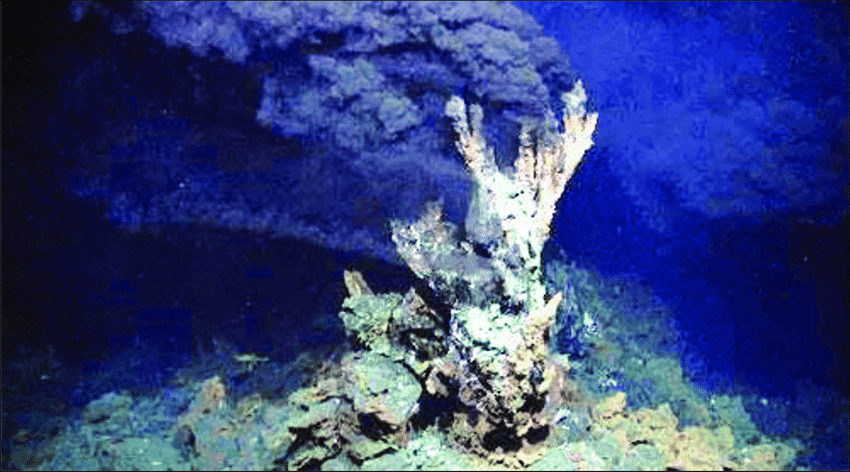
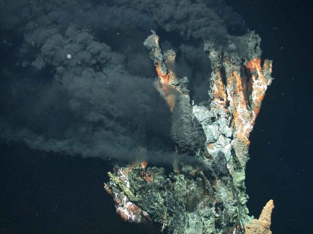
Black smokers, also known as hydrothermal vents, are underwater geothermal features found on the ocean floor. They are characterized by their dark appearance, caused by the presence of minerals and sulfide deposits that are expelled from the vents along with hot, mineral-rich fluids. Black smokers are typically located in areas where tectonic plates are spreading apart, such as along mid-ocean ridges.
Black smokers are formed when seawater seeps into the Earth’s crust through cracks and fissures, where it is heated by geothermal heat from the Earth’s mantle. The heated water becomes buoyant and rises back towards the ocean floor, carrying with it dissolved minerals and gases. As the hot water-rich with minerals and gases encounters the colder seawater, the minerals and gases precipitate out, forming chimney-like structures that can reach several meters in height. The minerals that are commonly deposited around black smokers include sulfides of iron, copper, zinc, and other metals, which give the smokers their characteristic black appearance.
Active Hydrothermal Vent Site (Black Smoker) Source: MARUM Research Center Ocean Margins, Bremen University
The fluids that are released from black smokers are extremely hot, often reaching temperatures above 300 degrees Celsius (572 degrees Fahrenheit), and are highly acidic and toxic to most forms of life. Despite these extreme conditions, black smokers are unique ecosystems that support diverse communities of organisms specially adapted to thrive in this harsh environment. These communities often include bacteria, archaea, and various species of animals such as tube worms, clams, shrimp, and other unique species that have evolved to utilize the energy and nutrients provided by the hydrothermal vent fluids.
Black smokers are considered to be important geologic and biological features on the ocean floor, providing insights into the Earth’s geothermal processes, as well as supporting unique and specialized ecosystems that are not found in other parts of the ocean. They have been the subject of extensive scientific research and exploration, helping to expand our understanding of the geology, chemistry, and biology of the deep-sea environment.
Importance of black smokers in geology
Black smokers, or hydrothermal vents, are of significant importance in geology due to several reasons:
Ore Deposits: Black smokers are associated with the formation of valuable ore deposits. The hot, mineral-rich fluids that are expelled from black smokers can carry significant amounts of metals, including copper, zinc, iron, and other elements. These metals precipitate out of the fluids and accumulate around the vent openings, forming mineral deposits that can be economically valuable. The study of black smokers has provided insights into the processes that contribute to the formation of these important mineral resources.
Geochemical Cycling: Black smokers play a critical role in the geochemical cycling of elements between the Earth’s crust and the ocean. The hot fluids released from black smokers contain dissolved minerals that are sourced from the Earth’s mantle, and these minerals are then transported to the ocean floor. As the fluids cool upon contact with the cold seawater, the minerals precipitate out and become part of the ocean floor sediments. This process contributes to the cycling of elements such as sulfur, carbon, and metals between the oceanic crust and the seawater, and has implications for global biogeochemical cycles and climate regulation.
Tectonic Processes: Black smokers are associated with tectonic processes, specifically with mid-ocean ridge systems where tectonic plates are spreading apart. The formation of black smokers is linked to the interaction between seawater and hot rocks in the Earth’s crust, which is related to the movement of tectonic plates. By studying black smokers, geologists can gain insights into the dynamics of plate tectonics, including the mechanisms of seafloor spreading, magma generation, and the formation of new oceanic crust.
Geothermal Energy: Black smokers are sources of geothermal energy, which is a form of renewable energy that can be harnessed for power generation. The hot fluids released from black smokers contain substantial thermal energy, and efforts have been made to explore the potential for utilizing this energy for power generation. The study of black smokers can provide valuable information about the geothermal processes and resources, contributing to the development of sustainable energy sources.
In summary, black smokers are important geologic features that provide insights into processes related to ore formation, geochemical cycling, tectonic processes, and geothermal energy. The study of black smokers has advanced our understanding of the Earth’s geology and has practical applications in various fields, including resource exploration, environmental science, and renewable energy development.
Geological Setting of Black Smokers
Black smokers, or hydrothermal vents, are typically found in specific geological settings known as mid-ocean ridges. Mid-ocean ridges are underwater mountain ranges that run through the world’s oceans and are formed by the process of seafloor spreading, which is driven by the movement of tectonic plates.
At mid-ocean ridges, tectonic plates are moving apart, and molten rock, known as magma, rises from the Earth’s mantle to fill the gap. This process leads to the formation of new oceanic crust as the magma solidifies upon contact with the cold seawater. As the new crust forms, seawater seeps into the cracks and fissures in the crust, where it gets heated by the underlying magma. The heated water becomes buoyant and rises back towards the ocean floor, carrying with it dissolved minerals and gases.
As the hot, mineral-rich fluids are released from the seafloor, they encounter the cold seawater, causing the minerals and gases to precipitate out and form chimney-like structures known as black smokers. These chimneys are made up of minerals such as sulfides of iron, copper, zinc, and other metals, which give the black smokers their characteristic dark appearance.
The geological setting of black smokers is therefore closely tied to the process of seafloor spreading and the associated upwelling of hot fluids from the Earth’s mantle. Mid-ocean ridges are the most common locations where black smokers are found, with well-known examples including the East Pacific Rise, the Mid-Atlantic Ridge, and the Juan de Fuca Ridge. However, black smokers can also be found in other geological settings, such as back-arc basins and subduction zones, where there are similar processes of fluid circulation and hydrothermal activity driven by tectonic processes.
The study of the geological setting of black smokers has provided important insights into the dynamics of seafloor spreading, magma generation, and the interaction between the Earth’s crust and mantle. It has also contributed to our understanding of the distribution and characteristics of hydrothermal vents and their associated mineral deposits, as well as the unique ecosystems that thrive around these extreme environments.
Formation and Composition of Black Smokers
Formation of Black Smokers: Black smokers, or hydrothermal vents, are formed through a complex process involving interactions between seawater and hot rocks in the Earth’s crust. The formation of black smokers can be summarized in the following steps:
Seawater Infiltration: Seawater infiltrates into cracks and fissures in the oceanic crust at mid-ocean ridges, which are underwater mountain ranges where tectonic plates are spreading apart. The seawater seeps into the crust through these openings, coming into contact with hot rocks that are heated by underlying magma.
Heating and Mineral Dissolution: The hot rocks heat the infiltrating seawater, causing it to become buoyant and rise back towards the seafloor. As the water comes into contact with the hot rocks, it dissolves minerals from the rocks, including sulfides of iron, copper, zinc, and other metals. These minerals are carried along with the heated water as it rises towards the surface.
Ascending Fluids and Chimney Formation: The hot, mineral-rich fluids ascend towards the seafloor and encounter the cold seawater. The temperature difference causes the dissolved minerals to precipitate out of the fluids and form chimney-like structures, which are composed of sulfide minerals. These chimneys, also known as black smokers, grow over time as the mineral-rich fluids continue to rise and interact with the cold seawater.
Composition of Black Smokers: Black smokers are composed of a variety of minerals that are precipitated from the hot fluids as they come into contact with the cold seawater. The composition of black smokers can vary depending on the specific geological setting and the temperature, pressure, and chemical composition of the fluids. However, the following are some of the main components typically found in black smokers:
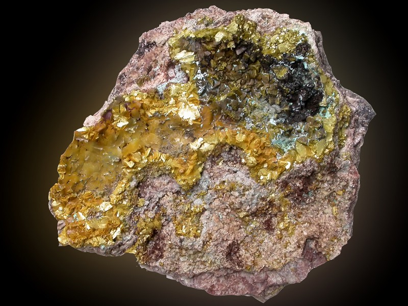
Sulfide Minerals: Black smokers are primarily composed of sulfide minerals, such as pyrite (FeS2), pyrrhotite (Fe1-xS), chalcopyrite (CuFeS2), sphalerite (ZnS), and bornite (Cu5FeS4). These minerals are formed through the precipitation of dissolved sulfide ions (S2-) from the hot fluids as they encounter the cold seawater.
Silicate Minerals: Silicate minerals, such as quartz (SiO2) and various clay minerals, may also be present in black smokers, depending on the composition of the rocks and fluids involved. These minerals are typically formed through the reaction of silica-rich fluids with the surrounding rocks.
Other Minerals: Black smokers can also contain other minerals, such as iron oxides (e.g., hematite, magnetite), manganese oxides, and barite (BaSO4), which can precipitate from the hot fluids as they mix with the cold seawater.
In addition to minerals, black smokers can also contain dissolved gases, such as methane (CH4) and hydrogen sulfide (H2S), which are released from the hot fluids. These gases can support unique ecosystems around black smokers, where specialized organisms thrive in the extreme conditions of high pressure, high temperature, and high concentrations of minerals and gases.
The specific composition of black smokers can provide important clues about the geological processes occurring in the underlying crust, as well as the potential for mineral resource formation and the unique ecosystems that are associated with these extreme environments.
Black Smokers as Hydrothermal Vents
Black smokers are a type of hydrothermal vent, which are geological features on the seafloor that are associated with the release of hot fluids from the Earth’s interior. Hydrothermal vents, including black smokers, are important and fascinating phenomena that have significant implications for geology, chemistry, biology, and even astrobiology.
Hydrothermal vents, including black smokers, are formed when seawater infiltrates into the cracks and fissures of the oceanic crust, gets heated by underlying magma, and rises back towards the seafloor, carrying with it dissolved minerals and gases. The hot, mineral-rich fluids are released from the seafloor, where they come into contact with the cold seawater, causing the minerals to precipitate out and form chimney-like structures, which are known as hydrothermal vents or black smokers, due to their dark coloration.
Hydrothermal vents, including black smokers, are unique and extreme environments that support diverse ecosystems, often referred to as “oases in the deep ocean.” These ecosystems thrive in the absence of sunlight and are fueled by chemosynthesis, a process where microbes use chemical energy from the minerals and gases in the vent fluids to produce organic matter, which serves as the basis of the food chain. These ecosystems are known for their high species diversity, with many unique and specialized organisms that are adapted to the extreme conditions of high pressure, high temperature, and high concentrations of minerals and gases.
Black smokers, in particular, are known for their characteristic chimney-like structures made of sulfide minerals, such as pyrite and chalcopyrite, which can form tall spires reaching several meters in height. These chimneys provide a unique habitat for various organisms, including bacteria, archaea, protists, and invertebrates, which form complex communities and often have specific adaptations to the extreme and dynamic conditions of hydrothermal vents.
The study of hydrothermal vents, including black smokers, has provided important insights into various scientific fields. In geology, the study of black smokers has improved our understanding of seafloor spreading, magma generation, and the formation of mineral deposits. In chemistry, it has shed light on the processes of mineral dissolution and precipitation, as well as the geochemical cycling of elements in the Earth’s crust. In biology, the study of hydrothermal vents has expanded our knowledge of extremophile organisms and their adaptations to extreme environments, as well as the potential for life beyond Earth in similar environments, such as in icy moons like Europa and Enceladus.
Overall, black smokers, as hydrothermal vents, are remarkable geological features that play a significant role in shaping the geology, chemistry, and biology of the deep ocean, and they continue to be a subject of intense scientific research and exploration.
Geochemical and Mineralogical Significance of Black Smokers
Black smokers, as hydrothermal vents, have great geochemical and mineralogical significance. They are unique geological features that release hot, mineral-rich fluids from the Earth’s interior, which interact with the surrounding seawater and seafloor, leading to important geochemical and mineralogical processes. Here are some of the key geochemical and mineralogical significance of black smokers:
Mineral Deposits: Black smokers are known to be associated with the formation of mineral deposits. As the hot vent fluids rise and mix with the cold seawater, they undergo rapid cooling and chemical reactions, leading to the precipitation of minerals. The chimney-like structures of black smokers are often composed of sulfide minerals, such as pyrite, chalcopyrite, and sphalerite, which can accumulate and form massive sulfide deposits. These deposits can contain valuable metals, such as copper, zinc, and gold, making black smokers economically significant as potential sources of mineral resources.
Geochemical Cycling: Black smokers are important for the geochemical cycling of various elements in the Earth’s crust. The vent fluids carry dissolved minerals and gases from the Earth’s interior, including elements such as sulfur, iron, and manganese. As these fluids mix with the seawater, chemical reactions occur, leading to the precipitation of minerals and the release of dissolved elements into the surrounding environment. These geochemical processes play a role in the global cycling of elements and can have significant impacts on local and regional geochemical budgets.
Redox Reactions: Black smokers are sites of redox (reduction-oxidation) reactions, which involve the transfer of electrons between different chemical species. The vent fluids are often rich in reduced species, such as hydrogen sulfide (H2S), which can react with oxygen from the seawater to form sulfuric acid (H2SO4). These redox reactions can result in the production of sulfuric acid, which can further react with minerals in the seafloor and surrounding rocks, leading to alteration and dissolution of minerals, and influencing the overall mineralogy and geochemistry of the area.
Unique Mineralogical Assemblages: Black smokers host unique mineralogical assemblages that are not commonly found in other geological settings. The high temperature, high pressure, and high concentrations of minerals and gases in the vent fluids create a unique environment that promotes the formation of specific minerals and mineralogical textures. For example, black smokers are known for the occurrence of minerals such as anhydrite, barite, and bornite, which are not typically found in other marine sedimentary environments. The study of these unique mineralogical assemblages provides insights into the conditions under which they form and can contribute to our understanding of mineralogy and mineral formation processes.
Understanding Geological Processes: Black smokers provide a window into the geological processes that occur at mid-ocean ridges, which are areas where tectonic plates are spreading apart. The interaction between the seawater and the underlying magma at mid-ocean ridges, which gives rise to black smokers, plays a crucial role in the formation of oceanic crust, magma generation, and seafloor spreading. The study of black smokers helps improve our understanding of these geological processes and their implications for plate tectonics, magma generation, and the evolution of the Earth’s crust.
In summary, black smokers have significant geochemical and mineralogical significance. They contribute to the formation of mineral deposits, play a role in geochemical cycling of elements, host unique mineralogical assemblages, and provide insights into geological processes. The study of black smokers continues to advance our understanding of geology, mineralogy, and geochemistry, and their importance in shaping the Earth’s crust and deep ocean environments.
Summary of key points Black smokers
Black smokers are hydrothermal vents located on the seafloor, characterized by high-temperature, mineral-rich fluids that are released from the Earth’s interior.
They are formed at mid-ocean ridges, where tectonic plates are spreading apart, and are associated with volcanic activity and magma generation.
The vent fluids from black smokers are hot, acidic, and rich in minerals such as sulfides, which can precipitate and form chimney-like structures.
Black smokers are important for the geochemical and mineralogical processes that occur at mid-ocean ridges, including the formation of mineral deposits, geochemical cycling of elements, redox reactions, and the development of unique mineralogical assemblages.
They provide insights into geological processes such as seafloor spreading, magma generation, and plate tectonics.
Black smokers are unique and extreme environments that support diverse ecosystems, including chemosynthetic bacteria and specialized marine fauna.
The study of black smokers advances our understanding of geology, mineralogy, geochemistry, and the evolution of the Earth’s crust and deep ocean environments.
Overall, black smokers are geologically significant features that play a crucial role in shaping the seafloor environment and provide valuable insights into various geological, mineralogical, and geochemical processes.
Black smokers FAQ
Q: What are black smokers?
A: Black smokers are hydrothermal vents located on the seafloor, characterized by high-temperature, mineral-rich fluids that are released from the Earth’s interior.
Q: Where are black smokers found?
A: Black smokers are typically found at mid-ocean ridges, which are underwater mountain ranges where tectonic plates are spreading apart, creating new seafloor. They can also be found in other geologically active areas, such as back-arc basins and subduction zones.
Q: How do black smokers form?
A: Black smokers form when seawater seeps into the seafloor through cracks and fractures and comes into contact with hot rocks and magma beneath the Earth’s crust. The heated water dissolves minerals from the rocks and rises back to the seafloor, forming a vent that releases the mineral-rich fluids as black smoke-like plumes.
Q: What is the temperature of black smoker fluids?
A: Black smoker fluids can reach extremely high temperatures, ranging from 200 to over 400 degrees Celsius (392 to over 752 degrees Fahrenheit), making them one of the hottest environments on Earth.
Q: What minerals are typically found in black smoker fluids?
A: Black smoker fluids are typically rich in minerals such as sulfides, sulfates, chlorides, and other metal-rich compounds. These minerals can precipitate and form chimney-like structures around the vent openings, known as “smokers”.
Q: What is the importance of black smokers in geology?
A: Black smokers are geologically significant as they provide insights into various geological processes, such as seafloor spreading, magma generation, and plate tectonics. They are also associated with the formation of mineral deposits and play a role in the global cycling of elements.
Q: Are there any life forms around black smokers?
A: Yes, black smokers support unique ecosystems that are adapted to extreme conditions. These ecosystems are based on chemosynthetic bacteria that derive energy from the minerals and chemicals in the vent fluids, and specialized marine fauna that feed on these bacteria.
Q: Can black smokers be harmful to the environment?
A: While black smokers are natural features, human activities such as deep-sea mining or exploration can potentially have harmful impacts on the fragile and unique ecosystems around black smokers. It is important to carefully manage and monitor these activities to minimize any potential negative environmental impacts.
Q: How are black smokers studied?
A: Studying black smokers often involves the use of remotely operated vehicles (ROVs) or manned submersibles to explore the deep-sea environment, collect samples of vent fluids, rocks, and fauna, and conduct various scientific measurements and analyses. Additionally, data from seafloor observatories, geophysical surveys, and other tools are used to study black smokers and their associated processes.
Q: What are the future research directions for black smokers?
A: Future research on black smokers may focus on understanding their role in the evolution of the Earth’s crust and deep ocean environments, investigating their potential for mineral resource exploration and exploitation, studying their impacts on climate and global geochemical cycling, and assessing their vulnerability to human activities and environmental changes.
These are just some of the frequently asked questions about black smokers, and the field of hydrothermal vent research continues to evolve as scientists uncover more information about these fascinating geologic features and their significance in various disciplines.
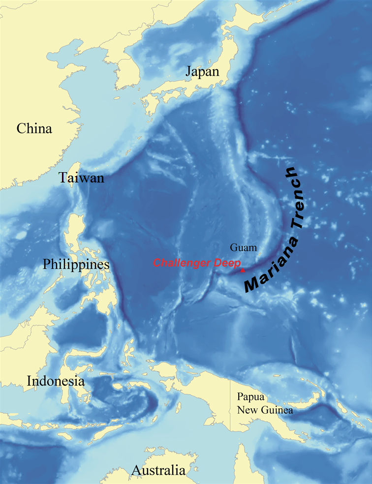
The Mariana Trench is the deepest known oceanic trench on Earth, located in the western Pacific Ocean. It reaches a maximum depth of about 10,925 meters (35,843 feet) at its lowest point, known as the Challenger Deep, making it the deepest known point in the world’s oceans. The Mariana Trench is named after the nearby Mariana Islands.
Some key facts about the Mariana Trench include:
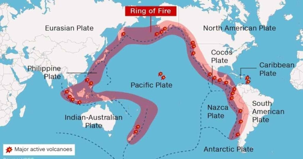
Location: The Mariana Trench is located in the western Pacific Ocean, east of the Mariana Islands and north of Papua New Guinea. It is part of the Pacific Ring of Fire, a region known for its frequent earthquakes and volcanic activity due to the convergence of tectonic plates.
Depth: The Challenger Deep, the deepest point within the Mariana Trench, reaches a maximum depth of about 10,925 meters (35,843 feet) below sea level. However, the exact depth may vary slightly as more accurate measurements are made through ongoing research and improved measurement techniques.
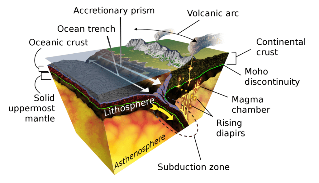
Geology: The Mariana Trench is formed by the process of subduction, where the Pacific Plate is forced beneath the Mariana Plate, a process known as the Mariana Trench subduction zone. The intense pressure and friction between the plates cause the oceanic crust to bend and sink, creating the deep trench.
Oceanic environment: The Mariana Trench is characterized by extreme environmental conditions, including high pressure, low temperatures, and darkness. These conditions create a unique and challenging environment that is home to a variety of specialized and unique species, some of which are found nowhere else on Earth. The study of the Mariana Trench provides valuable insights into deep-sea biodiversity, adaptations to extreme conditions, and the limits of life on Earth.
Exploration: The Mariana Trench has been the subject of extensive scientific exploration using remotely operated vehicles (ROVs) and deep-sea submersibles. The first manned descent to the Challenger Deep was conducted by the bathyscaphe Trieste in 1960, and subsequent expeditions have continued to study the geology, biology, and ecology of the Mariana Trench.
Environmental concerns: The Mariana Trench, like other oceanic trenches, is relatively remote and inaccessible, but it is not immune to human impacts. There are concerns about potential environmental impacts from activities such as deep-sea mining, pollution, and climate change on the delicate and unique ecosystems of the Mariana Trench. Responsible and sustainable management of this fragile environment is increasingly recognized as important.
Location of Mariana Trench
Geographical and Physical Characteristics
The Mariana Trench is located in the western Pacific Ocean and is known for its unique geographical and physical characteristics. Here are some key details:
Geographical Characteristics:
Location: The Mariana Trench is located in the western Pacific Ocean, east of the Mariana Islands and north of Papua New Guinea. It spans an area approximately 2,550 kilometers (1,580 miles) long and 69 kilometers (43 miles) wide at its widest point.
Depth: The Challenger Deep, the deepest point within the Mariana Trench, reaches a maximum depth of about 10,925 meters (35,843 feet) below sea level, making it the deepest known point in the world’s oceans.
Topography: The Mariana Trench is characterized by a V-shaped profile, with steep walls that descend sharply from the surrounding seabed to the Challenger Deep at its lowest point. The walls of the trench can reach heights of several kilometers and are studded with cliffs, ridges, and peaks.
Physical Characteristics:
Pressure: The extreme depth of the Mariana Trench results in immense water pressure. At the bottom of the trench, the pressure can reach over 1,000 times the atmospheric pressure at sea level, equivalent to around 1,086 kilograms per square centimeter (15,329 pounds per square inch).
Temperature: The water temperature in the Mariana Trench is generally near freezing, ranging from around 1 to 4 degrees Celsius (34 to 39 degrees Fahrenheit) due to the absence of sunlight and the influence of deep ocean currents.
Ecology: Despite the extreme environmental conditions, the Mariana Trench is home to a diverse array of unique and adapted species. Deep-sea organisms in the Mariana Trench have developed various adaptations to survive in the high-pressure, low-temperature, and low-food environments, including bioluminescence, slow metabolic rates, and specialized feeding mechanisms.
Seismic Activity: The Mariana Trench is located in the Pacific Ring of Fire, a region known for its frequent earthquakes and volcanic activity. The trench is associated with the Mariana Trench subduction zone, where the Pacific Plate is being forced beneath the Mariana Plate, leading to tectonic activity and the formation of earthquakes and volcanic features in the region.
These geographical and physical characteristics of the Mariana Trench make it a unique and fascinating area of study for geologists, marine biologists, and other scientists interested in understanding the mysteries of the deep ocean.
Highest and deepest points of earth
Unique geological and physical properties of the Mariana Trench
The Mariana Trench is known for its unique geological and physical properties, which set it apart from other oceanic trenches. Some of these properties include:
Extreme Depth: The Mariana Trench is the deepest known point in the world’s oceans, with the Challenger Deep reaching a maximum depth of about 10,925 meters (35,843 feet) below sea level. This extreme depth creates an environment of immense pressure, with pressures exceeding 1,000 times the atmospheric pressure at sea level.
Steep Walls: The walls of the Mariana Trench are incredibly steep, with cliffs, ridges, and peaks that can reach heights of several kilometers. The V-shaped profile of the trench creates a dramatic landscape that is distinct from other trenches.
Tectonic Activity: The Mariana Trench is located in the Pacific Ring of Fire, a region known for its frequent earthquakes and volcanic activity. The trench is associated with the Mariana Trench subduction zone, where the Pacific Plate is being forced beneath the Mariana Plate, leading to tectonic activity and the formation of earthquakes and volcanic features in the region.
Unique Sedimentation: The Mariana Trench exhibits unique sedimentation patterns due to its extreme depth and steep walls. The lack of sunlight and limited availability of organic material results in slow sedimentation rates, leading to the accumulation of fine-grained sediment and the preservation of ancient marine deposits.
Extreme Environmental Conditions: The Mariana Trench is characterized by extreme environmental conditions, including high pressure, low temperatures, and darkness. These conditions create a challenging environment for life to thrive, and the organisms that do inhabit the trench have developed unique adaptations to survive in this harsh environment.
Biodiversity: Despite the challenging environmental conditions, the Mariana Trench is home to a diverse array of unique and adapted species. Deep-sea organisms in the Mariana Trench have developed various adaptations to survive in the high-pressure, low-temperature, and low-food environments, including bioluminescence, slow metabolic rates, and specialized feeding mechanisms.
These unique geological and physical properties of the Mariana Trench make it a fascinating area of study for geologists, marine biologists, and other scientists interested in understanding the geology, ecology, and environmental conditions of the world’s deepest oceanic trench.
Marine Life in the Mariana Trench
The Mariana Trench, despite its extreme environmental conditions, is home to a diverse range of marine life. Although the extreme depths, high pressure, low temperatures, and darkness pose significant challenges to life, many organisms have adapted to thrive in this unique environment. Here are some key aspects of marine life in the Mariana Trench:
Adaptations to High Pressure: Many organisms in the Mariana Trench have developed specialized adaptations to cope with the immense pressure. These adaptations include flexible bodies, reduced skeletal structures, and high-pressure enzymes that allow them to withstand the crushing pressure at the bottom of the trench.
Bioluminescence: Bioluminescence, the ability to produce light, is common among many species in the Mariana Trench. Bioluminescent features are believed to serve a variety of functions, such as attracting prey, confusing predators, and communication in the dark depths where sunlight cannot penetrate.
Slow Metabolic Rates: The lack of food and energy in the deep ocean environment has led to the evolution of slow metabolic rates in many species in the Mariana Trench. This allows them to conserve energy in the low-food environment and survive for long periods without food.
Unique Feeding Mechanisms: Marine organisms in the Mariana Trench have evolved specialized feeding mechanisms to capture food in the pitch-black environment. Some species have long, slender bodies with large mouths and sharp teeth to capture prey, while others use bioluminescent lures or extendable jaws to catch food.
Species Diversity: The Mariana Trench is home to a wide range of species, including various species of fish, crustaceans, cephalopods, and other invertebrates. Many of these species are found exclusively in the deep trenches and have unique adaptations to survive in this extreme environment.
Potential for New Discoveries: Due to the extreme depths and remote location of the Mariana Trench, there is still much to learn about the marine life that inhabits this area. New species and previously unknown adaptations are continuously being discovered, making the Mariana Trench an area of ongoing scientific exploration and discovery.
The marine life in the Mariana Trench is a subject of fascination and research for marine biologists, ecologists, and other scientists, as it provides valuable insights into the adaptations and survival strategies of life in one of the most extreme and least explored environments on Earth.
Mariana Trench FAQ
Q: What is the Mariana Trench?
A: The Mariana Trench is the deepest known point in the world’s oceans, located in the western Pacific Ocean. It is a crescent-shaped trench that reaches a maximum depth of about 10,925 meters (35,843 feet) below sea level at its deepest point, known as the Challenger Deep.
Q: Where is the Mariana Trench located?
A: The Mariana Trench is located in the western Pacific Ocean, east of the Mariana Islands and near the Mariana Trench subduction zone. It spans an area between Japan to the north and Papua New Guinea to the south.
Q: How deep is the Mariana Trench?
A: The Mariana Trench reaches a maximum depth of about 10,925 meters (35,843 feet) at its deepest point, known as the Challenger Deep. This makes it the deepest known point in the world’s oceans.
Q: What are some unique features of the Mariana Trench?
A: The Mariana Trench is known for its extreme depth, reaching the deepest point in the world’s oceans. It also has steep walls, tectonic activity associated with the Mariana Trench subduction zone, unique sedimentation patterns, extreme environmental conditions, and diverse marine life with unique adaptations.
Q: What is the temperature and pressure like in the Mariana Trench?
A: The temperature in the Mariana Trench varies depending on the depth, but it generally ranges from about 1 to 4 degrees Celsius (34 to 39 degrees Fahrenheit). The pressure at the bottom of the trench can exceed 1,000 times the atmospheric pressure at sea level, reaching extreme levels of over 1,086 bar (15,750 psi).
Q: What is the significance of the Mariana Trench in scientific research?
A: The Mariana Trench is a significant area for scientific research due to its unique geological and physical properties, extreme environmental conditions, and diverse marine life. It provides valuable insights into deep-sea ecology, geology, biogeography, adaptation to extreme environments, and other scientific fields.
Q: Are there any human activities in the Mariana Trench?
A: As of current knowledge cutoff (September 2021), there have been limited human activities in the Mariana Trench due to its extreme depth and challenging environment. However, there have been deep-sea exploration missions, scientific expeditions, and some deep-sea technological testing in the region. There are ongoing discussions and debates about potential future human activities, such as deep-sea mining and its potential impacts on the Mariana Trench ecosystem.
Q: What are the threats to the Mariana Trench ecosystem?
A: The Mariana Trench ecosystem faces potential threats from human activities such as deep-sea mining, pollution, climate change, and habitat destruction. These activities may have direct or indirect impacts on the unique and fragile ecosystem of the Mariana Trench, and the potential consequences of these threats are still being studied.
Q: What are some recent discoveries in the Mariana Trench?
A: The Mariana Trench is a subject of ongoing scientific exploration, and new discoveries are continuously being made. Some recent discoveries include new species of deep-sea organisms, novel adaptations to extreme conditions, unique geological features, and insights into the biogeography and ecology of the trench. Scientific research in the Mariana Trench is an active and evolving field, and new findings are regularly published in scientific journals.
Q: Can humans survive in the Mariana Trench?
A: Due to its extreme depth, high pressure, low temperatures, and other challenging environmental conditions, the Mariana Trench is not a suitable environment for human survival without specialized equipment and technology.
Oceanic trenches are long, narrow depressions or deep valleys that occur in the Earth’s oceanic crust. They are the deepest parts of the world’s oceans and are typically located in the areas where tectonic plates meet. Oceanic trenches are formed by the process of plate tectonics, which involves the movement and interaction of the Earth’s lithosphere, the rigid outer layer of the Earth’s surface, consisting of the crust and part of the upper mantle.
Oceanic trenches are characterized by their steep sides and extremely deep depths, often reaching over 10,000 meters (32,800 feet) below sea level. The Challenger Deep, located in the Mariana Trench in the western Pacific Ocean, is the deepest known point in the world’s oceans, with a depth of about 10,924 meters (35,840 feet). Other well-known oceanic trenches include the Peru-Chile Trench in the southeastern Pacific Ocean, the Tonga Trench in the southwestern Pacific Ocean, and the Kermadec Trench in the southwestern Pacific Ocean.
Oceanic trenches are formed by the process of subduction, where one tectonic plate is forced beneath another plate, usually an oceanic plate being pushed beneath a continental plate or another oceanic plate. This process is caused by the movement of tectonic plates, as they are constantly shifting and interacting with each other. The friction and pressure created by the movement of these plates can cause the leading edge of the subducting plate to be pushed down into the mantle, creating a trench-like depression on the ocean floor.
Oceanic trenches are important geological features as they play a crucial role in the recycling of the Earth’s crust. As the oceanic plate is forced into the mantle and subjected to intense heat and pressure, it melts and forms magma. This magma can then rise back up to the surface through volcanic activity, forming new crust and contributing to the formation of new oceanic plates. Additionally, oceanic trenches are often associated with seismic activity, including earthquakes and tsunamis, due to the intense geological forces at work in these areas.
Oceanic crust is formed at an oceanic ridge, while the lithosphere is subducted back into the asthenosphere at trenches
Importance of oceanic trenches in geology and marine biology
Oceanic trenches are of significant importance in both geology and marine biology due to their unique geological and ecological characteristics. Here are some key aspects:
Geological Importance: Oceanic trenches provide valuable insights into the Earth’s geological processes. They are formed by subduction, a fundamental process in plate tectonics, where one tectonic plate is forced beneath another. The study of oceanic trenches helps scientists understand the dynamics of tectonic plate movements, including the processes of subduction, faulting, and seismic activity. These trenches also offer a window into the composition and structure of the Earth’s mantle, as the subducting plate is subjected to high pressure and temperature, causing chemical and physical changes in the rocks.
Marine Biodiversity: Oceanic trenches are unique and extreme environments that support a diverse array of marine life. Despite the extreme depth, high pressure, and low light conditions, trenches are home to various specialized and often endemic species, which are specially adapted to survive in these challenging conditions. Some examples of unique species found in oceanic trenches include deep-sea fishes like anglerfish, snailfish, and cusk eels, as well as deep-sea invertebrates like amphipods, isopods, and polychaete worms. Studying the biodiversity of these trenches can provide insights into the adaptation strategies of marine organisms to extreme environments and their ecological roles.
Ecological Processes: Oceanic trenches play a crucial role in the global carbon cycle and nutrient cycling. The high primary productivity in surface waters above trenches leads to the production of organic matter that sinks to the deep-sea floor, providing a source of food for deep-sea organisms. The trenches also act as “biological traps,” where organic material from the surface is transported to the deep-sea and sequestered, which has implications for global carbon cycling and climate regulation. The unique physical and chemical conditions of trenches, such as high pressure, low temperature, and high nutrient availability, create specific habitats that influence ecological processes, such as nutrient cycling, carbon sequestration, and biogeochemical cycling.
Evolutionary Studies: Oceanic trenches can serve as natural laboratories for studying the evolution of marine species. The isolation and unique environmental conditions of trenches can lead to the evolution of distinct populations and species with specialized adaptations. Studying the genetic and evolutionary characteristics of organisms in oceanic trenches can provide insights into the processes of speciation, adaptation, and evolutionary dynamics in extreme environments.
Resource Potential: Oceanic trenches may also have potential for the discovery of new resources, such as minerals and hydrocarbons. The unique geological processes and conditions in trenches may result in the accumulation of valuable resources, and ongoing research and exploration are being conducted to assess their resource potential.
In conclusion, oceanic trenches are important in geology and marine biology due to their significance in understanding Earth’s geological processes, supporting unique marine biodiversity, influencing ecological processes, providing insights into evolutionary studies, and potential resource exploration. Continued research and exploration of these extreme environments are critical for advancing our understanding of the Earth’s geology, biodiversity, and ecological processes, and their role in shaping the planet’s history and future.
Deep-sea trench
Formation of oceanic trenches
Oceanic trenches are formed through a geological process called subduction, which occurs at the convergent boundaries of tectonic plates. The process of subduction involves one tectonic plate being forced beneath another plate, usually an oceanic plate being pushed beneath either a continental plate or another oceanic plate. Here’s a step-by-step overview of the formation of oceanic trenches:
Convergent Plate Boundary: Oceanic trenches typically form at convergent plate boundaries, where two tectonic plates are moving towards each other. There are three types of convergent plate boundaries: oceanic-continental, oceanic-oceanic, and continental-continental.
Subduction: When an oceanic plate encounters either a continental plate or another oceanic plate at a convergent boundary, it is usually denser and sinks beneath the less dense plate in a process called subduction. The denser oceanic plate is forced to dive beneath the less dense plate due to gravity and the intense pressure exerted by the overlying plate.
Trench Formation: As the oceanic plate is subducted, it descends into the asthenosphere, the partially molten layer of the Earth’s upper mantle. The leading edge of the subducting plate is bent and deformed, creating a trench-like depression on the ocean floor. Over time, as the subduction continues, the trench deepens due to the accumulation of sediment and the bending and fracturing of the Earth’s crust.
Volcanic Activity: The subduction of the oceanic plate generates intense heat and pressure, causing the mantle to partially melt and form magma. This magma is less dense than the surrounding rock and rises towards the Earth’s surface, leading to volcanic activity. Volcanoes may form on the overriding plate or within the trench itself, creating a volcanic arc parallel to the trench.
Earthquakes and Tsunamis: The intense geological forces at work during subduction can also result in seismic activity, including earthquakes and tsunamis. As the subducting plate is forced deeper into the mantle, it can become stuck and accumulate stress, which is then released in the form of earthquakes. Tsunamis can also be generated by large earthquakes associated with subduction zones, as the sudden vertical movement of the seafloor can displace a large volume of water.
Ongoing Geological Process: The process of subduction and trench formation is ongoing and can continue for millions of years, as tectonic plates continue to move and interact. Over time, oceanic trenches may change in shape, size, and depth as a result of the complex interplay between subduction, tectonic plate movements, and geological processes.
In summary, oceanic trenches are formed through the process of subduction, where one tectonic plate is forced beneath another plate at convergent plate boundaries. This process leads to the formation of trenches on the ocean floor, along with associated volcanic activity, earthquakes, and tsunamis, and is an ongoing geological process that plays a crucial role in shaping the Earth’s crust and geology.
Characteristics of oceanic trenches
Oceanic trenches are unique features on the ocean floor and exhibit several characteristics that set them apart from other marine environments. Here are some key characteristics of oceanic trenches:
Depth: Oceanic trenches are the deepest parts of the world’s oceans, with some trenches reaching depths of over 10,000 meters (32,800 feet). The Challenger Deep in the Mariana Trench is the deepest known point in the ocean, with a depth of approximately 10,924 meters (35,840 feet).
Narrow and Long: Oceanic trenches are typically long and narrow depressions on the ocean floor, often stretching for hundreds or thousands of kilometers in length, but only a few tens of kilometers in width. They can have irregular shapes, with steep sides and a relatively flat bottom.
Subduction Zones: Oceanic trenches are often associated with subduction zones, where one tectonic plate is being forced beneath another plate. Subduction occurs at convergent plate boundaries, where two plates are moving towards each other, and the denser oceanic plate is forced to dive beneath the less dense plate.
Volcanic Activity: Oceanic trenches are often associated with intense volcanic activity. As the oceanic plate is forced beneath the overriding plate, it melts and forms magma, which can rise to the Earth’s surface and result in the formation of volcanic arcs parallel to the trench. Volcanic activity in trenches can lead to the formation of submarine volcanoes, seamounts, and volcanic islands.
Seismic Activity: Oceanic trenches are prone to frequent seismic activity, including earthquakes and tsunamis. The subduction of tectonic plates and the intense geological forces at work can result in the release of accumulated stress, leading to earthquakes. Large earthquakes associated with oceanic trenches can also trigger tsunamis, which are large ocean waves that can cause widespread damage when they reach the coastlines.
Unique Fauna: Despite the extreme conditions of high pressure, darkness, and low temperatures, oceanic trenches are home to unique and diverse ecosystems. Trenches support specialized fauna that are adapted to survive in the challenging environment, such as deep-sea fish, giant isopods, amphipods, and other deep-sea organisms.
Scientific Interest: Oceanic trenches are of great scientific interest as they provide valuable opportunities for studying the Earth’s geology, plate tectonics, and deep-sea ecosystems. Research conducted in oceanic trenches has contributed significantly to our understanding of Earth’s history, geology, and marine biology.
In summary, oceanic trenches are characterized by their extreme depth, narrow and long shape, association with subduction zones, volcanic and seismic activity, unique fauna, and scientific significance. They are fascinating and important features of the world’s oceans, offering unique opportunities for scientific exploration and research.
Geologic significance of oceanic trenches
Oceanic trenches are geologically significant features that provide important clues about the Earth’s geology and plate tectonics. Here are some key geologic significances of oceanic trenches:
Subduction Zones: Oceanic trenches are often associated with subduction zones, where one tectonic plate is being forced beneath another plate. Subduction is a fundamental process in plate tectonics and is responsible for the recycling of oceanic lithosphere back into the Earth’s mantle. As the denser oceanic plate sinks into the mantle, it melts and forms magma, which can rise to the Earth’s surface and result in the formation of volcanic arcs parallel to the trench. This process plays a crucial role in the formation of volcanic mountain chains, such as the Andes in South America and the Cascades in North America.
Plate Boundary Interactions: Oceanic trenches mark the locations where tectonic plates are converging, or moving towards each other. Trenches are typically associated with other types of plate boundaries, such as subduction zones, transform faults, or spreading centers. The interactions and dynamics of tectonic plates at oceanic trenches are important for understanding plate tectonics and the geophysical processes that shape the Earth’s crust.
Geological Record: Oceanic trenches provide a unique geological record of the Earth’s history. Sediments that accumulate in trenches contain valuable information about past environmental conditions, including changes in climate, sea level, and sedimentation rates. These sediments can also contain fossils and other evidence of ancient marine life, providing insights into the evolution of marine ecosystems over time.
Earthquake and Seismic Studies: Oceanic trenches are often associated with intense seismic activity, including earthquakes. The subduction of tectonic plates and the intense geological forces at work can result in the release of accumulated stress, leading to earthquakes. Studying the seismic activity associated with oceanic trenches can provide valuable information about the Earth’s interior structure, faulting, and earthquake processes, contributing to our understanding of seismology and earthquake hazard assessment.
Geomorphology: Oceanic trenches exhibit unique geomorphic features, such as steep cliffs, ridges, and troughs, that provide insights into the geological processes shaping the ocean floor. These features can be studied to understand the erosional and depositional processes that occur in trenches, as well as the impact of tectonic forces on the morphology of the oceanic crust.
Geodynamic Models: Oceanic trenches serve as natural laboratories for studying geodynamic processes, including the dynamics of subduction and the behavior of tectonic plates. Data collected from oceanic trenches, such as bathymetry, seismic profiles, and geochemical analyses, provide important constraints for developing and testing geodynamic models that explain the behavior and evolution of the Earth’s lithosphere.
In summary, oceanic trenches are geologically significant features that provide important information about plate tectonics, subduction processes, earthquake activity, sedimentation history, geomorphology, and geodynamic models. They are key areas of scientific research for understanding the geology and geophysics of the Earth’s crust and have contributed significantly to our understanding of the dynamic processes that shape the Earth’s surface.
Mariana trench undersea landscape illustration
Geographic distribution
Oceanic trenches are distributed around the world in various ocean basins. Some of the major oceanic trenches and their geographic distribution are as follows:
The Mariana Trench: Located in the western Pacific Ocean, the Mariana Trench is the deepest known oceanic trench on Earth, reaching a maximum depth of about 11,034 meters (36,201 feet). It is located east of the Mariana Islands and is part of the Pacific Ring of Fire, which is a region known for its intense tectonic activity.
The Tonga Trench: Located in the South Pacific Ocean, the Tonga Trench stretches from the northern part of New Zealand to the island of Fiji. It is known for its steep slopes and deep trenches, with a maximum depth of about 10,882 meters (35,702 feet).
The Kermadec Trench: Also located in the South Pacific Ocean, the Kermadec Trench is located north of New Zealand and extends towards Tonga. It is known for its complex geological features and reaches a maximum depth of about 10,047 meters (32,963 feet).
The Puerto Rico Trench: Located in the Atlantic Ocean, the Puerto Rico Trench is the deepest part of the Atlantic Ocean, reaching a maximum depth of about 8,376 meters (27,480 feet). It is located north of Puerto Rico and is known for its steep slopes and deep trenches.
The Peru-Chile Trench: Located off the western coast of South America in the Pacific Ocean, the Peru-Chile Trench is known for its active subduction zone and intense seismic activity. It reaches a maximum depth of about 8,065 meters (26,460 feet) and extends from the southern part of Peru to the central part of Chile.
The Japan Trench: Located in the northwestern Pacific Ocean, the Japan Trench is known for its complex tectonic features and intense seismic activity. It reaches a maximum depth of about 7,742 meters (25,397 feet) and extends along the eastern coast of Japan.
These are just some examples of the major oceanic trenches and their geographic distribution. Oceanic trenches are found in various locations in the world’s oceans and are associated with subduction zones and other tectonic processes, which contribute to their geographic distribution.
Deepest oceanic trenches
The deepest known oceanic trenches on Earth are:
The Challenger Deep: Located in the Mariana Trench in the western Pacific Ocean, the Challenger Deep is the deepest known point in the world’s oceans, reaching a maximum depth of about 10,925 meters (35,843 feet). It is named after the HMS Challenger, which conducted the first scientific survey of the trench in 1875.
Hossack Deep: Located in the Tonga Trench in the South Pacific Ocean, Hossack Deep is the second deepest known point in the world’s oceans, reaching a maximum depth of about 10,052 meters (32,970 feet). It is named after the HMS Hossack, which conducted a scientific survey of the trench in 1930.
Sirena Deep: Also located in the Mariana Trench in the western Pacific Ocean, Sirena Deep is the third deepest known point in the world’s oceans, reaching a maximum depth of about 10,065 meters (32,998 feet). It is named after the scientific research vessel RV Sirena, which conducted a survey of the trench in 1960.
Hossack Deep (Puerto Rico Trench): Located in the Puerto Rico Trench in the Atlantic Ocean, this Hossack Deep is a separate trench from the one in the Tonga Trench mentioned earlier. It reaches a maximum depth of about 8,648 meters (28,373 feet) and is the fourth deepest known point in the world’s oceans.
Brownson Deep: Located in the Izu-Ogasawara Trench in the western Pacific Ocean, Brownson Deep is the fifth deepest known point in the world’s oceans, reaching a maximum depth of about 8,380 meters (27,493 feet). It is named after the USS Brownson, which conducted a survey of the trench in 1963.
It’s important to note that the depths of oceanic trenches may vary slightly due to ongoing research and improved measurement techniques. However, these are generally considered the deepest known points in the world’s oceans as of the current scientific knowledge.
Oceanic trenches FAQ
Q: What are oceanic trenches?
A: Oceanic trenches are long, narrow, and deep depressions on the ocean floor formed by tectonic plate movements where one tectonic plate is forced beneath another in a process called subduction.
Q: How deep are oceanic trenches?
A: Oceanic trenches can reach extreme depths, with the Challenger Deep in the Mariana Trench being the deepest known point in the world’s oceans at about 10,925 meters (35,843 feet) below sea level.
Q: Where are oceanic trenches located?
A: Oceanic trenches are located in various ocean basins around the world. Some examples include the Mariana Trench in the western Pacific Ocean, the Tonga Trench in the South Pacific Ocean, and the Puerto Rico Trench in the Atlantic Ocean.
Q: What causes oceanic trenches?
A: Oceanic trenches are primarily formed by the process of subduction, where one tectonic plate is forced beneath another due to their convergence. The denser oceanic plate sinks into the mantle beneath the less dense continental or another oceanic plate, creating a trench.
Q: What is the significance of oceanic trenches in geology?
A: Oceanic trenches are significant in geology as they provide insights into the process of plate tectonics, which is a fundamental concept in Earth’s geology. They also contribute to the formation of volcanic arcs and earthquakes, and are associated with the recycling of crustal material back into the Earth’s mantle.
Q: What is the significance of oceanic trenches in marine biology?
A: Oceanic trenches can have unique and extreme environments that support diverse and specialized marine ecosystems. These environments are characterized by high pressures, low temperatures, and lack of sunlight, and are home to a variety of unique species, some of which are found nowhere else on Earth. The study of these ecosystems provides valuable insights into deep-sea biodiversity and adaptations to extreme conditions.
Q: Can oceanic trenches cause tsunamis?
A: Yes, oceanic trenches can potentially trigger tsunamis. Subduction of tectonic plates along oceanic trenches can result in sudden upward or downward movement of the ocean floor, which can displace large volumes of water and trigger tsunamis, especially if associated with a large seismic event such as an earthquake.
Q: Are oceanic trenches being explored by humans?
A: Oceanic trenches have been the subject of extensive exploration by humans, primarily using remotely operated vehicles (ROVs) and deep-sea submersibles. However, due to the extreme depths, high pressures, and other challenges, exploration of oceanic trenches remains challenging and limited, and our understanding of these environments is still evolving.
Q: Are there any environmental concerns associated with oceanic trenches?
A: While oceanic trenches are relatively remote and inaccessible, they can still be impacted by human activities such as deep-sea mining, pollution, and climate change. The potential environmental impacts of these activities on oceanic trenches and their ecosystems are not yet fully understood, and there is increasing recognition of the need for responsible and sustainable management of these fragile and unique environments.
The Ring of Fire is a geographical region in the Pacific Ocean known for its high level of volcanic and seismic activity. It is an area where numerous tectonic plates meet and interact, resulting in frequent earthquakes, volcanic eruptions, and the formation of deep ocean trenches.
The Ring of Fire forms a horseshoe-shaped arc that stretches for about 40,000 kilometers (25,000 miles) along the Pacific Ocean, encompassing the coasts of several countries, including the United States, Canada, Mexico, Japan, Russia, Indonesia, and several countries in South America.
Ring of Fire
The region is characterized by the presence of several subduction zones, where one tectonic plate is forced beneath another, resulting in the formation of volcanoes and earthquakes. These subduction zones are responsible for the formation of the Pacific Ring of Fire, which is the most active and geologically complex region on Earth.
The Ring of Fire is home to some of the most famous and active volcanoes in the world, such as Mount St. Helens in the United States, Mount Fuji in Japan, and Mount Pinatubo in the Philippines. It is also known for its frequent and powerful earthquakes, including the devastating 2004 Indian Ocean earthquake and tsunami, which caused widespread destruction in several countries.
Despite its geologically active nature, the Ring of Fire is also known for its rich deposits of natural resources, such as minerals, oil, and gas, which have contributed to economic development in many countries along its coastline.
However, the Ring of Fire also poses significant risks to human populations living in the region, as the frequent volcanic eruptions, earthquakes, and tsunamis can result in loss of life, property damage, and disruption to infrastructure and economic activities. As such, monitoring and studying the geology and activity of the Ring of Fire is an important area of scientific research to better understand and mitigate the hazards associated with living in this dynamic region.
Geology
The geology of the Ring of Fire is complex and dynamic, shaped by the interaction of multiple tectonic plates and the resulting geological processes, including subduction, volcanic activity, and seismic activity.
The Ring of Fire is primarily characterized by the presence of subduction zones, where one tectonic plate is forced beneath another. This occurs when two tectonic plates converge, with one plate being denser and heavier than the other. As the denser plate sinks into the Earth’s mantle, it undergoes intense heat and pressure, causing it to melt and generate magma. The magma then rises to the surface, leading to volcanic eruptions and the formation of volcanoes.
The subduction zones in the Ring of Fire are associated with deep ocean trenches, which are some of the Earth’s deepest parts. These trenches, such as the Marianas Trench in the western Pacific Ocean, are formed when the denser tectonic plate is forced downward, creating a depression in the ocean floor.
The volcanic activity in the Ring of Fire is intense, with numerous active volcanoes dotting the region. These volcanoes are typically stratovolcanoes, also known as composite volcanoes, which are characterized by steep slopes and a conical shape. They are formed by repeated eruptions of lava, ash, and other materials, building up layers of volcanic rock over time.
The Ring of Fire is also known for its high seismic activity, with frequent earthquakes occurring along the subduction zones. These earthquakes are caused by the release of built-up stress as the tectonic plates move and interact with each other. The earthquakes in the Ring of Fire can be particularly powerful and destructive, and they are closely monitored by seismologists and geologists for early warning systems and hazard mitigation.
In addition to subduction-related processes, the geology of the Ring of Fire also includes other tectonic interactions, such as transform faults and crustal deformation. Transform faults occur when two tectonic plates slide past each other horizontally, and they can be responsible for significant seismic activity. Crustal deformation, on the other hand, refers to the bending, stretching, and warping of the Earth’s crust due to tectonic forces, which can result in the formation of mountain ranges, basins, and other geological features.
Overall, the geology of the Ring of Fire is complex and dynamic, shaped by the ongoing interaction of multiple tectonic plates and the resulting volcanic and seismic activity. It is a region of both natural beauty and geological hazards, and it continues to be a subject of scientific research and monitoring to better understand and mitigate the risks associated with living in this active geologic zone.
Ring of Fire
Ring of Fire FAQ
Q: What is the Ring of Fire?
A: The Ring of Fire is a geographical region in the Pacific Ocean known for its high level of volcanic and seismic activity. It is an area where multiple tectonic plates converge, resulting in frequent earthquakes, volcanic eruptions, and the formation of deep ocean trenches.
Q: Where is the Ring of Fire located?
A: The Ring of Fire forms a horseshoe-shaped arc that stretches for about 40,000 kilometers (25,000 miles) along the Pacific Ocean, encompassing the coasts of several countries, including the United States, Canada, Mexico, Japan, Russia, Indonesia, and several countries in South America.
Q: What causes the volcanic and seismic activity in the Ring of Fire?
A: The volcanic and seismic activity in the Ring of Fire is primarily caused by subduction, which occurs when one tectonic plate is forced beneath another. As the denser plate sinks into the Earth’s mantle, it generates magma, which then rises to the surface, leading to volcanic eruptions. The release of built-up stress as the tectonic plates move and interact with each other also causes frequent earthquakes in the region.
Q: What types of volcanoes are found in the Ring of Fire?
A: The Ring of Fire is known for stratovolcanoes, also known as composite volcanoes, which are characterized by steep slopes and a conical shape. Stratovolcanoes are formed by repeated eruptions of lava, ash, and other materials, building up layers of volcanic rock over time.
Q: Is the Ring of Fire dangerous?
A: The Ring of Fire is known for its high level of volcanic and seismic activity, which can pose significant risks to human populations living in the region. The frequent volcanic eruptions, earthquakes, and tsunamis can result in loss of life, property damage, and disruption to infrastructure and economic activities. However, with proper monitoring, preparedness, and mitigation measures, the risks can be minimized.
Q: Are there any natural resources in the Ring of Fire?
A: Yes, the Ring of Fire is also known for its rich deposits of natural resources, such as minerals, oil, and gas. These resources have contributed to economic development in many countries along the Ring of Fire coastline.
Q: Is the Ring of Fire monitored for volcanic and seismic activity?
A: Yes, the Ring of Fire is actively monitored by seismologists, volcanologists, and other scientists using various tools and techniques, including seismometers, GPS, satellite monitoring, and ground-based observations. Monitoring helps in early warning systems, hazard assessment, and mitigation efforts.
Q: What are some famous volcanoes in the Ring of Fire?
A: Some famous volcanoes in the Ring of Fire include Mount St. Helens in the United States, Mount Fuji in Japan, Mount Pinatubo in the Philippines, and Mount Merapi in Indonesia, among others.
Q: Can tourism be done in the Ring of Fire?
A: While the Ring of Fire is known for its volcanic and seismic activity, and can pose risks, there are also opportunities for tourism. Many areas within the Ring of Fire have stunning landscapes, unique geological features, and cultural significance, which can attract tourists. However, it is essential to follow safety guidelines, adhere to local regulations, and be aware of potential hazards when visiting these areas.
Q: How does the Ring of Fire impact the environment?
A: The Ring of Fire’s volcanic and seismic activity can have both positive and negative impacts on the environment. Volcanic eruptions can create new landforms, fertile soils, and unique habitats. However, eruptions can also release gases, ash, and debris that can impact air quality, water quality, and ecosystems. Earthquakes can cause
The Ice Age, also known as the Pleistocene Epoch, was a period of geological time that lasted from about 2.6 million years ago to 11,700 years ago. It was characterized by the widespread presence of glaciers and extensive ice sheets covering large portions of the Earth’s surface. The Ice Age had a significant impact on the Earth’s climate, geography, and ecosystems.
During the Ice Age, global temperatures were much colder than they are today, resulting in the formation of glaciers and ice sheets. These massive ice masses covered vast areas of land, including much of North America, Europe, and Asia, as well as parts of South America and Australia. The weight of the ice caused the Earth’s surface to depress, creating deep valleys and shaping the landscape as we see it today.
The ice age
The Ice Age had a profound impact on the distribution of plant and animal species. Many species of plants and animals were forced to adapt to the cold conditions or migrate to warmer regions. Some species, particularly those adapted to colder climates, thrived during the Ice Age, while others went extinct. Large mammals, such as mammoths, mastodons, and sabre-toothed cats, roamed the ice-covered landscapes, and early humans, such as Neanderthals, also lived during this time.
The Ice Age also had a significant influence on human history. Early humans had to adapt to the challenging environmental conditions, developing new hunting techniques, creating tools, and finding ways to survive in harsh landscapes. As the climate changed and the ice sheets retreated, human populations migrated and settled in different areas, shaping the development of human civilization.
The end of the Ice Age was marked by a warming trend that resulted in the retreat of glaciers and the eventual establishment of the modern climate patterns that we see today. The warming also led to changes in sea level, as the melting ice caused the oceans to rise, reshaping coastlines and creating new landscapes.
In summary, the Ice Age was a prolonged period of cold climate characterized by the presence of glaciers and ice sheets, which had a profound impact on the Earth’s climate, geography, and ecosystems, as well as human history.
Importance and significance of the Ice Age in Earth’s history
The Ice Age, also known as the Pleistocene Epoch, was a significant period in Earth’s history with profound impacts on the planet’s climate, landscape, ecosystems, and human evolution. Here are some key points highlighting the importance and significance of the Ice Age:
Climate Change: The Ice Age was marked by significant climate fluctuations, with repeated cycles of glacial advances and retreats. These climate changes had a major influence on global temperatures, sea levels, and precipitation patterns, shaping Earth’s climate system and contributing to the formation of distinct ecosystems and habitats.
Landscape Shaping: Glacial advances during the Ice Age led to the formation of characteristic glacial landforms, such as moraines, eskers, and cirques, which continue to shape the landscape of many regions today. Glacial erosion and deposition also affected the distribution of soils, rivers, and lakes, influencing local and regional ecosystems.
Biodiversity: The Ice Age was a time of diverse and often large-bodied fauna, known as megafauna, including iconic species such as mammoths, saber-toothed cats, and giant ground sloths. These animals played important ecological roles and their extinction during the Ice Age had significant impacts on ecosystems and the evolutionary history of life on Earth.
Human Evolution: The Ice Age was a critical period for the evolution of early humans, including Neanderthals and Homo sapiens. The challenging environmental conditions of the Ice Age likely influenced human adaptations, such as tool use, hunting strategies, and cultural practices, which shaped the development of modern human societies.
Geological Records: Ice cores from the Greenland and Antarctic ice sheets provide valuable records of past climate and environmental changes during the Ice Age. These records have greatly contributed to our understanding of Earth’s climate system, including changes in temperature, greenhouse gas concentrations, and atmospheric composition, and have implications for understanding current and future climate change.
Modern Landscapes: The effects of the Ice Age can still be seen in many parts of the world today. For example, glacially-carved valleys, lakes, and fjords, as well as glacial deposits, are prominent features in many landscapes, providing evidence of the past impact of glaciers and the importance of the Ice Age in shaping Earth’s surface.
In conclusion, the Ice Age was a significant and transformative period in Earth’s history, with far-reaching impacts on climate, landscapes, ecosystems, and human evolution. The study of the Ice Age provides valuable insights into the dynamics of the Earth’s climate system, the evolution of life on our planet, and the interplay between climate, landscapes, and ecosystems.
Causes of the Ice Age
The causes of the Ice Age, also known as the Pleistocene Epoch, are complex and multifaceted, involving a combination of various factors. Scientists believe that multiple factors contributed to the onset of the Ice Age, including changes in Earth’s orbit, atmospheric composition, and ocean currents. Here are some of the key causes that are thought to have played a role in the Ice Age:
Milankovitch Cycles: Changes in Earth’s orbit around the Sun, known as Milankovitch cycles, are believed to have been a significant factor in triggering the Ice Age. These cycles include changes in eccentricity (the shape of Earth’s orbit), axial tilt (the tilt of Earth’s axis), and precession (the wobble of Earth’s axis). These cycles affect the distribution and intensity of sunlight on Earth, leading to changes in climate over long periods of time.
Changes in Atmospheric Composition: Changes in the composition of Earth’s atmosphere, particularly the concentration of greenhouse gases, can impact global temperatures and climate. During the Ice Age, there is evidence that levels of greenhouse gases, such as carbon dioxide and methane, were lower than during interglacial periods, which could have contributed to cooling of the planet.
Ocean Currents: Ocean currents play a crucial role in distributing heat around the planet, influencing climate patterns. Changes in ocean currents, such as the circulation of warm and cold water in the Atlantic Ocean, can impact climate by affecting heat transport and circulation patterns. It is believed that changes in ocean currents during the Ice Age may have influenced the distribution of heat and contributed to the cooling of the planet.
Land Configuration: The configuration of land masses, particularly the arrangement of continents and mountains, can also impact climate. During the Ice Age, the positioning of continents and the formation of large ice sheets over land masses, such as North America and Eurasia, could have affected atmospheric circulation patterns, precipitation, and temperature distribution.
Feedback Mechanisms: Feedback mechanisms, where changes in one aspect of the climate system trigger further changes, may have played a role in amplifying the cooling effects during the Ice Age. For example, the growth of ice sheets can lead to increased reflection of sunlight, which in turn can further cool the planet and promote the growth of more ice.
It’s important to note that the causes of the Ice Age are still a topic of ongoing scientific research, and the exact mechanisms and interactions between different factors are not yet fully understood. However, it is widely believed that a combination of these factors contributed to the onset and maintenance of the Ice Age, resulting in the significant climatic and environmental changes that characterized this epoch.
Milankovitch Cycles
Geological and Climatic Changes during the Ice Age
The Ice Age, or the Pleistocene Epoch, was marked by significant geological and climatic changes on Earth. The advance and retreat of large ice sheets, changes in sea level, and shifts in climate patterns had profound effects on the planet’s landscape and climate system. Here are some key geological and climatic changes that occurred during the Ice Age:
Glacial Advances and Retreats: One of the most prominent features of the Ice Age was the advance and retreat of large ice sheets, particularly in the northern hemisphere. During glacial advances, massive ice sheets, several kilometers thick, spread over large areas, eroding and shaping the landscape as they moved. Glacial retreats occurred when the ice sheets melted and moved back, leaving behind characteristic landforms such as moraines, eskers, and drumlins.
Sea Level Changes: The formation of large ice sheets during the Ice Age led to changes in sea level. When large volumes of water were locked up in ice sheets, sea level dropped, exposing continental shelves and creating land bridges between continents. During glacial retreats, as the ice sheets melted and water returned to the oceans, sea level rose, flooding coastal areas and reshaping coastlines.
Climate Fluctuations: The Ice Age was characterized by significant climate fluctuations, with cycles of glacial advances and retreats lasting tens of thousands of years. During glacial periods, the climate was generally colder and drier, with large areas covered by ice and reduced precipitation. During interglacial periods, when the ice sheets retreated, the climate was relatively warmer and wetter, with different vegetation patterns and ecosystems.
Changes in Vegetation and Ecosystems: The changing climate during the Ice Age had a profound impact on vegetation and ecosystems. As the ice sheets advanced, they displaced existing ecosystems, and cold-adapted vegetation, such as tundra and boreal forests, spread into lower latitudes. During interglacial periods, with warmer and wetter conditions, more temperate vegetation, such as deciduous forests, expanded.
Extinction of Megafauna: The Ice Age saw the extinction of numerous large-bodied fauna, known as megafauna, including iconic species such as mammoths, saber-toothed cats, and giant ground sloths. The cold and changing environments, combined with overhunting by early humans, are believed to have played a role in the extinction of these megafauna species, leading to significant changes in ecosystems and biodiversity.
Geological Records: The Ice Age left behind extensive geological records, such as glacial deposits, moraines, and lake sediments, which provide valuable evidence of past climate and environmental changes. Ice cores from Greenland and Antarctica also contain records of past climate, including changes in temperature, greenhouse gas concentrations, and atmospheric composition, which contribute to our understanding of Earth’s climate system.
Landscape Evolution: The dynamic processes of glacial advances and retreats during the Ice Age shaped the landscape of many regions. Glacial erosion and deposition created characteristic landforms such as U-shaped valleys, fjords, and cirques. Glacial meltwater also carved out river valleys and formed large lakes. These landscape features are still evident in many parts of the world today, showcasing the long-lasting effects of the Ice Age on Earth’s geology.
In conclusion, the Ice Age was a period of significant geological and climatic changes on Earth. Glacial advances and retreats, sea level changes, climate fluctuations, changes in vegetation and ecosystems, extinction of megafauna, and geological records are some of the key features that characterized the Ice Age and left a lasting impact on the planet’s landscape and climate system. The study of these changes provides valuable insights into Earth’s history and helps us understand the complex interactions between climate,
Fauna and Flora of the Ice Age
The Ice Age, or the Pleistocene Epoch, was marked by significant changes in fauna and flora as a result of the dynamic climate and environmental conditions during this time period. The advance and retreat of large ice sheets, changing temperatures, and shifting ecosystems had profound effects on the distribution and diversity of plant and animal species. Here are some key aspects of the fauna and flora of the Ice Age:
Megafauna: The Ice Age was home to a wide range of large-bodied fauna, known as megafauna. These included iconic species such as mammoths, mastodons, saber-toothed cats, giant ground sloths, and woolly rhinoceroses, among others. Many of these megafauna species were adapted to the cold and harsh environments of the Ice Age, with long shaggy fur, large body size, and specialized feeding habits.
Extinct Species: The Ice Age saw the extinction of numerous species of megafauna, as well as smaller animals, due to a combination of changing climates, loss of habitat, and overhunting by early humans. The disappearance of these species led to significant changes in ecosystems and biodiversity. For example, the extinction of mammoths and other large herbivores affected the structure and composition of grasslands and forests, leading to changes in vegetation patterns and nutrient cycling.
Adaptations to Cold Environments: Many plant and animal species during the Ice Age developed specialized adaptations to survive in the cold environments. For example, some animals had thick fur, hibernated during the winter, or migrated to warmer areas. Some plant species developed adaptations to tolerate cold temperatures, such as conifers that have needle-like leaves to reduce water loss and withstand harsh winter conditions.
Ecosystem Shifts: The changing climate during the Ice Age resulted in shifts in ecosystems and changes in vegetation patterns. As the ice sheets advanced and retreated, different vegetation types, such as tundra, boreal forests, and deciduous forests, expanded and contracted in response to changing temperatures and precipitation patterns. These shifts in ecosystems influenced the distribution and abundance of plant and animal species, shaping the biodiversity and ecological dynamics of the time.
Endemic Species: The isolation of certain regions during the Ice Age, due to glacial advances and sea level changes, led to the development of endemic species. Endemic species are unique to a particular geographic area and may have evolved distinct characteristics and adaptations to survive in their isolated habitats. Some examples of Ice Age endemic species include unique plant species in isolated mountain ranges or islands, as well as specialized animal species that evolved in isolated pockets of habitats.
Fossil Records: The Ice Age has left behind a rich fossil record of plants and animals that provide valuable insights into the diversity, distribution, and adaptations of fauna and flora during this time period. Fossil remains of megafauna, pollen records, and preserved plant remains in lake sediments and peat deposits have provided important information about the composition and structure of Ice Age ecosystems.
Human Influence: The Ice Age also marked the emergence of early humans, who played a significant role in shaping the fauna and flora of this time period. Early humans were skilled hunters and gatherers, and their activities, such as hunting and fire management, influenced the distribution and abundance of plant and animal species. Human interactions with the Ice Age fauna and flora had both direct and indirect effects on the ecosystems and biodiversity of the time.
In conclusion, the Ice Age was a time of significant changes in the fauna and flora of the Earth. Megafauna, extinct species, adaptations to cold environments, ecosystem shifts, endemic species, fossil records, and human influence are some of the key aspects that characterize the fauna and flora of the Ice Age. The study of Ice Age fauna and flora
Fauna and Flora of the Ice Age
Human Interactions with the Ice Age
During the Ice Age, early humans, also known as hominins, had interactions with the environment and the fauna and flora of that time period. These interactions had both direct and indirect effects on the ecosystems and biodiversity of the Ice Age. Here are some key aspects of human interactions with the Ice Age:
Hunting: Early humans were skilled hunters and gatherers, and hunting played a significant role in their survival during the Ice Age. They hunted a variety of animals, including large megafauna such as mammoths, mastodons, and other large herbivores. Hunting by early humans had direct impacts on the population dynamics of these animals and could have led to their overhunting and eventual extinction in some areas.
Fire Management: Early humans were known to use fire as a tool during the Ice Age. They used fire for various purposes, including cooking food, providing warmth, and as a tool for hunting and managing landscapes. The use of fire could have had indirect effects on the vegetation patterns and ecosystem dynamics of the time, as it could have influenced plant growth, nutrient cycling, and the distribution of certain plant species.
Migration and Adaptation: Early humans were highly mobile during the Ice Age and migrated to different regions in search of resources, including food, water, and shelter. Human migration could have influenced the distribution of plant and animal species, as well as the development of adaptations in response to different environmental conditions. For example, early humans adapted to cold environments by developing clothing, shelter, and other technologies to cope with the harsh conditions.
Cultural and Technological Innovations: Early humans during the Ice Age developed various cultural and technological innovations that had impacts on the environment and biodiversity. For example, the development of tools for hunting and processing food allowed early humans to efficiently exploit resources and could have influenced the population dynamics of certain plant and animal species. Cultural practices, such as rituals and social organization, could have also influenced resource use and management by early humans.
Art and Symbolism: Early humans during the Ice Age also left behind artistic and symbolic expressions in the form of cave paintings, rock art, and other artifacts. These artistic expressions provide insights into their relationship with the environment and the fauna and flora of the time. For example, cave paintings depicting animals can provide information about the species that were present during the Ice Age and their cultural significance to early humans.
Human-Animal Interactions: Early humans likely had complex interactions with the animals of the Ice Age. They would have relied on animals for food, clothing, shelter, and other resources, and may have developed cultural beliefs and practices related to animals. Some early human groups may have also had spiritual or symbolic connections with animals, which could have influenced their behaviors and interactions with the fauna of the time.
Impact on Biodiversity: Human activities during the Ice Age, including hunting, fire management, migration, and technological innovations, could have had both positive and negative impacts on biodiversity. Some early human activities could have led to local extinctions of certain plant and animal species, while others could have influenced species distribution, abundance, and community dynamics. Early humans were an integral part of the Ice Age ecosystems and likely played a role in shaping the biodiversity and ecological dynamics of that time.
In conclusion, human interactions with the Ice Age were complex and multifaceted. Early humans had direct impacts on the fauna and flora of the Ice Age through hunting, fire management, migration, cultural and technological innovations, and other activities. These interactions likely influenced the distribution, abundance, and dynamics of plant and animal species during this time period, and provide valuable insights into the role of humans in shaping the ecosystems and biodiversity of the Ice Age.
End of the Ice Age
The end of the Ice Age, also known as deglaciation or the termination of the Pleistocene epoch, was a period of significant environmental and climatic changes that marked the transition from the peak of the last glacial period to the interglacial period in which we currently live. The end of the Ice Age is believed to have occurred approximately 11,700 years ago, although the exact timing and causes are still debated among scientists. Here are some key aspects of the end of the Ice Age:
Melting of Glaciers: One of the most significant events during the end of the Ice Age was the melting of large ice sheets and glaciers that covered vast areas of land during the peak of the last glacial period. As temperatures gradually warmed, the ice sheets and glaciers began to melt, leading to the release of massive amounts of water into the oceans. This resulted in rising sea levels and reshaping of coastlines, with the subsequent flooding of low-lying areas.
Changes in Climate: The end of the Ice Age also marked a transition to a warmer and more stable climate compared to the extreme cold of the glacial period. As the ice sheets and glaciers melted, they released large amounts of freshwater into the oceans, which disrupted ocean currents and affected global climate patterns. This led to changes in temperature, precipitation, and atmospheric circulation patterns, which in turn influenced the distribution of plant and animal species.
Expansion of Habitats: As the ice sheets and glaciers melted, new habitats were created as previously ice-covered areas became available for colonization by plants and animals. This led to the expansion of forests, grasslands, and other ecosystems, providing opportunities for new species to thrive and adapt to the changing environment.
Changes in Sea Level: The melting of ice sheets and glaciers during the end of the Ice Age caused a significant rise in sea level, leading to the flooding of coastal areas and the reshaping of coastlines. This had profound impacts on marine and coastal ecosystems, as well as human populations that were dependent on coastal resources.
Migration of Species: The end of the Ice Age also resulted in the migration of plant and animal species as their habitats shifted in response to changing climate and environmental conditions. Species that were adapted to the cold and arid conditions of the glacial period had to adapt or migrate to new areas as temperatures warmed, leading to changes in species distribution, abundance, and diversity.
Human Adaptation: Early humans, who were present during the end of the Ice Age, had to adapt to the changing environment and shifting ecosystems. This likely influenced their hunting, gathering, and other subsistence strategies, as well as their cultural practices and technologies. Human populations had to adjust to the changing availability of resources and shifting landscapes, which may have influenced their settlement patterns, social organization, and cultural developments.
Extinction of Ice Age Megafauna: The end of the Ice Age also saw the extinction of many large mammals, known as Ice Age megafauna, such as mammoths, mastodons, saber-toothed cats, and giant ground sloths. The exact causes of these extinctions are still debated among scientists, but a combination of climate change, habitat loss, overhunting by humans, and other factors likely played a role.
In conclusion, the end of the Ice Age was a period of significant environmental and climatic changes that had profound impacts on the Earth’s ecosystems, biodiversity, and human populations. It marked the transition from the extreme cold of the glacial period to the warmer interglacial period we currently live in, and had far-reaching effects on the distribution, abundance, and dynamics of plant and animal species, including the extinction of Ice Age megafauna. The end of the Ice Age is a critical period in
Q: What was the Ice Age?
A: The Ice Age, also known as the Pleistocene Epoch, was a period of geological time that lasted from about 2.6 million years ago to 11,700 years ago. It was characterized by the widespread presence of glaciers and extensive ice sheets covering large portions of the Earth’s surface, resulting in colder global temperatures.
Q: What caused the Ice Age?
A: The causes of the Ice Age are complex and multifactorial, involving a combination of astronomical, geophysical, and atmospheric factors. One of the main factors believed to have triggered the Ice Age is changes in Earth’s orbital parameters, known as Milankovitch cycles, which affect the amount and distribution of solar radiation reaching the Earth’s surface. Other factors include changes in atmospheric composition, such as variations in greenhouse gas concentrations, and interactions between the atmosphere, ocean, and land surfaces.
Q: How did the Ice Age affect the Earth’s climate?
A: The Ice Age had a significant impact on the Earth’s climate, resulting in colder temperatures and the formation of glaciers and ice sheets. The advance and retreat of glaciers during the Ice Age caused changes in temperature, precipitation patterns, and sea levels, which in turn influenced the distribution of plant and animal species, shaped landscapes, and affected human populations.
Q: What were some key features of the Ice Age?
A: Some key features of the Ice Age include the presence of extensive glaciers and ice sheets, the formation of glacial landforms such as moraines, drumlins, and eskers, changes in sea levels due to the growth and retreat of ice sheets, the evolution of unique plant and animal species adapted to cold environments, and the development of early human cultures during this time.
Q: How did the Ice Age impact ecosystems and species?
A: The Ice Age had a significant impact on ecosystems and species. The advance of glaciers caused changes in habitats and climate, leading to the extinction of some species and the adaptation and migration of others. Many species of plants and animals had to adapt to the cold climate or move to warmer regions. The Ice Age also influenced the evolution of unique species adapted to cold environments, such as woolly mammoths, saber-toothed cats, and cave bears, which are now extinct.
Q: How did early humans cope with the Ice Age?
A: Early humans, such as Neanderthals and early Homo sapiens, had to adapt to the challenging environmental conditions of the Ice Age. They developed new hunting techniques, created tools from available resources, and migrated to different regions to find suitable habitats. Early humans also adapted their clothing, shelter, and social systems to survive in the harsh landscapes of the Ice Age, which had a significant impact on the development of human cultures and societies.
Q: How did the Ice Age end?
A: The Ice Age ended gradually over thousands of years, with a warming trend that resulted in the retreat of glaciers and the eventual establishment of the modern climate patterns that we see today. The causes of the end of the Ice Age are complex and not fully understood, but changes in Earth’s orbital parameters, atmospheric greenhouse gas concentrations, and other factors likely played a role in the transition from the Ice Age to the present interglacial period.
Q: How is the study of the Ice Age conducted?
A: The study of the Ice Age is conducted through various scientific disciplines, including geology, paleoclimatology, paleontology, archaeology, and climate modeling. Scientists use a combination of methods, such as field studies, laboratory analyses, dating techniques, computer simulations, and interdisciplinary approaches, to study glacial landforms, climate records, fossils, human remains, and other geological and biological evidence related to the Ice Age.
Q: What are some notable Ice Age sites or discoveries?
A: There are several notable Ice Age sites and discoveries that have contributed to our understanding of this geological period. Some examples include:
La Brea Tar Pits, USA: Located in Los Angeles, California, the La Brea Tar Pits are famous for their well-preserved fossils of Ice Age animals, including saber-toothed cats, dire wolves, and mammoths. These fossils provide valuable insights into the biodiversity and ecology of the Ice Age.
Lascaux Cave, France: Lascaux Cave is known for its Paleolithic cave paintings, which date back to around 15,000 years ago during the Ice Age. The paintings depict various animals, such as horses, bison, and deer, and provide important clues about the cultural and artistic practices of early humans during this time.
Ice Age Art: Arrival of the Modern Mind Exhibition, UK: This exhibition, held at the British Museum in London, showcased a collection of Ice Age art, including sculptures, engravings, and paintings created by early humans during the Paleolithic period. These artworks shed light on the creativity and symbolic expression of Ice Age cultures.
Ice Age National Scenic Trail, USA: The Ice Age National Scenic Trail is a long-distance hiking trail that spans over 1,000 miles across the state of Wisconsin in the United States. The trail features landscapes shaped by glacial activity during the Ice Age, including eskers, kettles, and moraines, providing a unique opportunity to observe the geologic features of the Ice Age up close.
Greenland Ice Core Project: The Greenland Ice Core Project (GRIP) is a scientific research project that involves drilling deep ice cores from the Greenland ice sheet. These ice cores provide valuable climate records dating back hundreds of thousands of years, allowing scientists to reconstruct past climate conditions and study changes in greenhouse gas concentrations, temperature, and other parameters during the Ice Age.
These are just a few examples of the many notable Ice Age sites and discoveries that have contributed to our understanding of this fascinating period in Earth’s history. The study of the Ice Age continues to be an active area of research, and new discoveries are constantly emerging, providing valuable insights into the Earth’s past climate and ecosystems.
How many ice ages have there been in Earth’s history?
The Earth has experienced several ice ages throughout its history, with alternating periods of glacial advance and retreat. The exact number of ice ages that have occurred in Earth’s history is a topic of scientific research and debate among geologists and climatologists. However, it is generally accepted that there have been at least five major ice ages in Earth’s history, spanning millions of years. These are:
Huronian glaciation (2.4 to 2.1 billion years ago): This is considered the earliest known ice age in Earth’s history, based on geological evidence. It occurred during the Proterozoic Eon and is believed to have been caused by changes in the composition of the Earth’s atmosphere, leading to a “snowball Earth” scenario with widespread glaciation.
Cryogenian glaciation (720 to 635 million years ago): This ice age is believed to have been the most severe in Earth’s history, with evidence of global glaciation during the Neoproterozoic Era. It is thought to have been caused by a combination of factors including changes in atmospheric composition, plate tectonics, and the position of continents.
Andean-Saharan glaciation (460 to 430 million years ago): This ice age occurred during the Late Ordovician to Early Silurian periods, resulting in widespread glaciation in the Southern Hemisphere, particularly in present-day South America and Africa.
Late Paleozoic ice age (360 to 260 million years ago): This ice age, also known as the “Carboniferous-Permian ice age,” occurred during the Late Paleozoic Era and is believed to have been caused by changes in atmospheric carbon dioxide levels, as well as the formation of the supercontinent Pangaea.
Pleistocene ice age (2.58 million years ago to 11,700 years ago): This is the most recent and well-known ice age, often referred to as the “Ice Age” in popular culture. It was characterized by repeated glacial advances and retreats, resulting in the formation of ice sheets and glaciers that covered large parts of North America, Europe, and Asia.
It’s important to note that these ice ages are part of a complex cycle of climate change on Earth, with multiple factors contributing to their occurrence, including changes in greenhouse gas concentrations, plate tectonics, solar activity, and other natural processes. The study of Earth’s ice ages and their causes is an ongoing area of scientific research and continues to shed light on the planet’s climatic history.
Uniformitarianism is a fundamental principle in geology that suggests that the same geological processes and natural laws that operate today have been operating throughout Earth’s history, and that they can be used to explain the geological features and formations found in the past. In other words, the present is the key to the past.
The concept of uniformitarianism was popularized by the geologist Charles Lyell in the 19th century, and it has since become a foundational principle in modern geology. The principle implies that the processes and forces that shape the Earth’s surface, such as erosion, deposition, volcanic activity, and tectonic movements, have operated at similar rates and with similar effects over long periods of geological time.
Uniformitarianism is important in geology because it provides a framework for understanding and interpreting the geological history of the Earth. By observing and studying the geological processes that are currently occurring, geologists can make inferences about the past geological events and conditions that shaped the Earth’s surface. It helps geologists develop hypotheses and explanations for the formation of rocks, minerals, fossils, and landforms, and it allows them to reconstruct past environments, climates, and ecosystems.
Uniformitarianism also has implications for the study of Earth’s history and the prediction of future geological events. By understanding the processes that have shaped the Earth’s surface in the past, geologists can make predictions about future geological events, such as earthquakes, volcanic eruptions, and erosion patterns. It also plays a role in applied geology, such as in the exploration and exploitation of natural resources, as it provides insights into the formation and distribution of mineral and energy resources.
Historical background and development of the concept
The concept of uniformitarianism originated in the late 18th and early 19th centuries as a response to prevailing theories about the Earth’s history. Prior to uniformitarianism, the dominant view was catastrophism, which proposed that the Earth’s geological features were primarily the result of catastrophic and sudden events, such as global floods or divine interventions, that were not necessarily applicable to modern processes.
Uniformitarianism was popularized by the Scottish geologist James Hutton in the late 18th century, often referred to as the “Father of Modern Geology.” Hutton proposed that the Earth’s geological features were the result of slow, gradual processes that operated over long periods of time, and that the same processes could be observed in operation in the present-day world. He argued that the Earth’s history should be explained by the same natural laws and processes that are currently observable, rather than invoking catastrophic events.
However, it was the English geologist Charles Lyell who further developed and popularized the concept of uniformitarianism in the early 19th century. In his influential work “Principles of Geology,” published between 1830 and 1833, Lyell argued that the same geological processes that are observed today, such as erosion, sedimentation, and volcanic activity, have been operating throughout Earth’s history, and that these processes, acting gradually over long periods of time, can explain the formation of geological features.
Lyell’s ideas had a profound impact on the field of geology, challenging the prevailing views of catastrophism and providing a new framework for understanding the Earth’s geological history. His work laid the foundation for the development of modern geology and the establishment of uniformitarianism as a fundamental principle in the field.
Since then, uniformitarianism has been refined and expanded upon by subsequent generations of geologists, and it has become a guiding principle in the study of the Earth’s history and processes. It has been integrated into various branches of geology, such as stratigraphy, sedimentology, geomorphology, and paleontology, and continues to play a central role in modern geological research and understanding of the Earth’s geological history.
Key proponents of uniformitarianism
Uniformitarianism was developed and popularized by several key proponents, including:
James Hutton: Often referred to as the “Father of Modern Geology,” Hutton was a Scottish geologist who first proposed the concept of uniformitarianism in the late 18th century. He argued that the Earth’s geological features were the result of slow, gradual processes that could be observed in operation in the present-day world, and that the same processes could explain the formation of geological features in the past.
Charles Lyell: An English geologist, Lyell further developed and popularized the concept of uniformitarianism in the early 19th century. In his influential work “Principles of Geology,” he argued that the same geological processes that are observed today have been operating throughout Earth’s history, and that these processes, acting gradually over long periods of time, can explain the formation of geological features. Lyell’s work had a profound impact on the field of geology and helped establish uniformitarianism as a fundamental principle.
Sir Charles Darwin: While best known for his work on evolution, Darwin also made significant contributions to the understanding of geology and uniformitarianism. In his book “The Structure and Distribution of Coral Reefs” published in 1842, Darwin used observations of modern coral reefs and their formation to support the idea of uniformitarianism, arguing that the same gradual processes of coral growth and subsidence could explain the formation of ancient coral reefs found in the fossil record.
William “Strata” Smith: An English geologist, Smith is known for his work in stratigraphy, the study of rock layers or strata. In the early 19th century, Smith made important observations and mapped the distribution of fossils in rock layers, which helped establish the principle of faunal succession, a key component of uniformitarianism. His work laid the foundation for the development of modern stratigraphy and our understanding of the Earth’s geological history.
James Hall: An American geologist, Hall made significant contributions to the understanding of uniformitarianism in the mid-19th century. He studied rock formations in New York and made detailed observations of sedimentary rocks and their fossils, which he used to develop the concept of facies, or distinctive sets of sedimentary rocks with similar characteristics. Hall’s work helped refine our understanding of sedimentary processes and environments, and further supported the principles of uniformitarianism.
These key proponents of uniformitarianism, along with many other geologists and scientists, have contributed to the development and refinement of this fundamental principle in geology, shaping our modern understanding of the Earth’s geological history and processes.
James Hutton
Principles of Uniformitarianism
Uniformitarianism is a fundamental principle in geology that suggests that the same geological processes and natural laws that operate today have been operating throughout Earth’s history, and can be used to explain the formation of geological features in the past. The principles of uniformitarianism can be summarized as follows:
Uniformity of natural laws: The fundamental physical, chemical, and biological laws that govern the Earth’s processes are consistent and have remained unchanged over time. This principle assumes that the same natural laws that are observed today were also in operation in the past.
Uniformity of processes: Geological processes, such as erosion, sedimentation, volcanic activity, and tectonic movements, have operated at similar rates and intensities throughout Earth’s history. The processes that shape the Earth’s surface today, acting over long periods of time, can explain the formation of geological features in the past.
Uniformity of time: The passage of time in the past has been similar to the present, with geological processes occurring gradually over long periods of time. This principle suggests that the same time scales used to measure geological processes today can be applied to the past.
Faunal and floral succession: Fossils found in rocks can be used to establish the relative ages of rock layers and can provide evidence of changes in past life forms. The principle of faunal and floral succession suggests that different fossils are found in different layers of rock, and that the fossil assemblages can be used to identify relative ages and changes in past ecosystems.
Original horizontality: Sedimentary rocks are typically deposited in horizontal layers, or strata, indicating that the Earth’s surface was relatively flat when the rocks formed. This principle suggests that tilting, folding, and faulting of rocks occurred after their initial formation.
Superposition: In an undisturbed sequence of sedimentary rocks, the youngest rocks are typically found at the top, while the oldest rocks are found at the bottom. This principle allows geologists to establish relative ages of rock layers based on their position in the rock sequence.
These principles of uniformitarianism provide a framework for understanding the Earth’s geological history and the processes that have shaped the planet’s surface. They are widely used by geologists in the interpretation of rock formations, the reconstruction of past environments, and the development of geological models and theories. However, it is important to note that uniformitarianism is not an absolute principle, and exceptions can occur due to unique geological events or conditions. Nonetheless, it remains a fundamental concept in geology and has greatly contributed to our understanding of the Earth’s geological history.
Charles Lyell
Historical Examples of Uniformitarianism
Uniformitarianism is a concept that has been widely applied in geology to understand past geological events and formations based on present-day processes and observations. Here are some historical examples where uniformitarianism has been used to interpret geological features:
Grand Canyon, USA: The Grand Canyon in Arizona, USA, is a classic example where uniformitarianism has been applied to interpret its formation. The layers of sedimentary rocks exposed in the Grand Canyon are believed to have been formed over millions of years by the same geological processes that are observed today, such as erosion by the Colorado River and deposition of sediment. By studying the modern-day erosion rates of the Colorado River and the types of sediment being transported, geologists have used the principle of uniformitarianism to infer that the Grand Canyon was formed over a long period of time by the gradual erosion of the Colorado River.
Mississippi River Delta, USA: The Mississippi River Delta is another example where uniformitarianism has been applied. The delta is formed by the deposition of sediment carried by the Mississippi River as it flows into the Gulf of Mexico. By studying the processes of sediment transport and deposition in modern deltas, geologists have used uniformitarianism to interpret the ancient delta deposits preserved in the rock record. This has provided valuable insights into the geological history, sea-level changes, and environmental conditions of the past.
Fossil record: The fossil record provides a rich source of evidence for the application of uniformitarianism. By studying the distribution and characteristics of fossils in rocks, geologists have been able to infer the past environments, climates, and changes in life forms on Earth. The principle of faunal and floral succession, which is based on uniformitarianism, has been used to establish the relative ages of rock layers and reconstruct past ecosystems based on the fossils preserved in them.
Volcanic eruptions: Volcanic eruptions provide another example where uniformitarianism has been applied. By studying the processes and products of modern volcanic eruptions, such as lava flows, pyroclastic deposits, and ash fallouts, geologists can interpret ancient volcanic eruptions preserved in the rock record. This allows them to understand the types of volcanic activity, eruption styles, and volcanic hazards that may have occurred in the past.
These are just a few examples of how uniformitarianism has been applied in geology to interpret past geological events and formations based on present-day processes and observations. It demonstrates the value of uniformitarianism as a guiding principle in understanding the Earth’s geological history and reconstructing past environments and events.
Controversies and Debates
Uniformitarianism has been a widely accepted principle in geology for many years, but it has also faced some controversies and debates. Here are some notable controversies and debates associated with uniformitarianism:
Catastrophism vs. Uniformitarianism: In the early days of geology, there was a debate between the proponents of catastrophism and uniformitarianism. Catastrophism was a competing theory that suggested that past geological events were primarily the result of catastrophic and sudden events, such as global floods, earthquakes, and volcanic eruptions, rather than gradual and uniform processes. This debate was prominent in the 18th and 19th centuries, with notable figures such as Georges Cuvier and Charles Lyell advocating for catastrophism and uniformitarianism, respectively. Ultimately, uniformitarianism gained wider acceptance in the scientific community, and catastrophism lost favor as the dominant geological paradigm. However, there are still ongoing debates and discussions on the role of catastrophic events in shaping the Earth’s geological history.
Rates of geological processes: Another controversy related to uniformitarianism is the debate about the rates of geological processes. While uniformitarianism assumes that geological processes have operated at similar rates and intensities throughout Earth’s history, there is ongoing debate about the actual rates of processes such as erosion, sedimentation, and tectonic movements in the past. Some scientists argue that the rates of geological processes may have varied significantly in the past, and that uniformitarianism may not always accurately represent the past geological conditions. This debate is ongoing, with ongoing research and discussions to better understand the rates of geological processes in the past and their implications for interpreting the geological record.
Non-uniform processes: Uniformitarianism assumes that the same geological processes that occur today were also responsible for shaping the Earth’s surface in the past. However, there are instances where non-uniform processes, such as rare and extreme events like meteor impacts or large-scale landslides, may have had significant geological effects in the past. These events may not be readily observable in the present-day processes, and their significance in shaping the geological record can be a topic of debate among geologists. This highlights the challenges in applying uniformitarianism to all geological scenarios and the need to consider non-uniform processes in certain contexts.
Role of human activity: In recent times, human activity has become a significant geological force that can shape the Earth’s surface and ecosystems. Anthropogenic activities such as mining, deforestation, and climate change can have profound impacts on the Earth’s geology, and their effects may not be consistent with the principles of uniformitarianism. Some geologists argue that human activities have become a dominant geological force and need to be considered in interpreting the geological record, challenging the traditional notions of uniformitarianism. This is an active area of debate and research in the field of geology.
In conclusion, while uniformitarianism has been a widely accepted principle in geology, it has also faced controversies and debates. These debates often revolve around the rates of geological processes, the role of catastrophic events, the significance of non-uniform processes, and the effects of human activity on geological formations. These debates highlight the dynamic nature of scientific understanding and the ongoing efforts to refine our interpretations of the Earth’s geological history.
Significance and Applications of Uniformitarianism
Uniformitarianism has significant importance in the field of geology and has various applications in understanding the Earth’s geological history and processes. Here are some key significance and applications of uniformitarianism:
Interpretation of the geological record: Uniformitarianism provides a guiding principle for interpreting the geological record. By assuming that the same geological processes that are observed today have operated in a similar manner in the past, geologists can infer the past conditions of the Earth’s surface, such as ancient environments, climates, and ecosystems, based on the preserved geological formations. This allows geologists to reconstruct the Earth’s history, including the formation of rock layers, the development of landforms, the deposition of sediments, and the evolution of life on Earth.
Prediction of future geological processes: Uniformitarianism also allows geologists to make predictions about future geological processes. By understanding the fundamental principles and processes that govern the Earth’s geology, geologists can apply this knowledge to predict and mitigate geological hazards, such as earthquakes, volcanic eruptions, landslides, and floods. This has practical applications in land use planning, resource management, and environmental protection.
Comparative studies: Uniformitarianism enables geologists to make comparisons between present-day geological processes and ancient geological formations. By studying present-day geological processes and their effects, geologists can gain insights into the formation and evolution of ancient rocks, landforms, and ecosystems. This allows for comparative studies between modern and ancient environments, helping to understand long-term trends, changes, and patterns in the Earth’s history.
Geological dating and correlation: Uniformitarianism is also used in the dating and correlation of geological formations. By assuming that the same geological processes that are observed today have operated in a similar manner in the past, geologists can use relative dating and absolute dating techniques to determine the ages of rocks and fossils, and correlate them across different locations. This allows for the construction of geological timelines and the establishment of a geologic timescale, which is fundamental in understanding the Earth’s history and the evolution of life on Earth.
Development of geologic models and theories: Uniformitarianism serves as a foundation for the development of geologic models and theories. By understanding the fundamental principles and processes that govern the Earth’s geology, geologists can develop conceptual models and theories to explain various geological phenomena, such as mountain building, erosion, sedimentation, and climate change. These models and theories provide a framework for further research, exploration, and understanding of the Earth’s geological history and processes.
In conclusion, uniformitarianism has significant importance and various applications in geology. It provides a guiding principle for interpreting the geological record, predicting future geological processes, conducting comparative studies, dating and correlating geological formations, and developing geologic models and theories. It has been a fundamental concept in geology and has greatly contributed to our understanding of the Earth’s history and processes over geological timescales.
Summary of the key points of uniformitarianism
Uniformitarianism is a fundamental concept in geology that suggests that the same geological processes that are observed today have operated in a similar manner in the past, and will likely continue to operate in the future. Here are the key points of uniformitarianism:
Present is the key to the past: Uniformitarianism suggests that the processes and laws that govern the Earth’s geology today have also operated in the past, allowing geologists to interpret ancient geological formations based on present-day processes.
Principles of uniformity: Uniformitarianism is based on two principles – uniformity of law, which suggests that the laws of nature are constant throughout time and space, and uniformity of process, which suggests that the processes that operate today have operated in a similar manner in the past.
Historical background and development: Uniformitarianism developed as a response to the earlier concept of catastrophism and gained prominence in the 19th century with the work of geologists like James Hutton and Charles Lyell, who emphasized the importance of understanding gradual, ongoing processes in explaining the Earth’s geological history.
Key proponents: James Hutton and Charles Lyell are considered as key proponents of uniformitarianism, and their works, such as Hutton’s “Theory of the Earth” and Lyell’s “Principles of Geology,” helped establish uniformitarianism as a guiding principle in geology.
Significance and applications: Uniformitarianism has significant importance in geology and has various applications, including interpreting the geological record, predicting future geological processes, conducting comparative studies, dating and correlating geological formations, and developing geologic models and theories.
Controversies and debates: Despite its wide acceptance, uniformitarianism has also faced controversies and debates, including criticisms of oversimplification, challenges from alternative concepts, and discussions about the role of catastrophic events in Earth’s history.
In summary, uniformitarianism is a fundamental concept in geology that suggests that present-day geological processes can be used to understand the Earth’s geological history. It has been a guiding principle in geology, contributing to our understanding of the Earth’s processes, history, and evolution over time.
Lithium (Li) ore is a type of rock or mineral that contains significant concentrations of lithium, a soft, silver-white alkali metal with the atomic number 3 and symbol Li on the periodic table. Lithium is known for its unique properties, such as being the lightest metal, having the highest electrochemical potential, and being highly reactive with water.
Lithium is a critical element used in various applications, especially in the production of rechargeable batteries, which are used in a wide range of devices such as electric vehicles, smartphones, laptops, and energy storage systems. Additionally, lithium is also used in other industries, including aerospace, ceramics, glass, and pharmaceuticals.
Lithium ores are typically found in the Earth’s crust and can be extracted through various mining methods, depending on the location and composition of the ore deposit. The most common types of lithium ores are spodumene, lepidolite, and petalite. These ores are typically found in countries such as Australia, Chile, Argentina, China, and Canada, which are major producers of lithium.
The extraction of lithium from ores involves several processes, including mining, concentration, and chemical processing. The ore is first mined from the earth’s crust and then undergoes concentration to increase the lithium content. Chemical processing methods, such as roasting, leaching, and precipitation, are then used to extract lithium compounds, which can be further processed to produce lithium carbonate, lithium hydroxide, or other lithium compounds, depending on the desired end-use applications.
As demand for lithium continues to grow due to the increasing use of rechargeable batteries in various applications, the exploration, mining, and processing of lithium ores have become a significant part of the global mining industry. However, the extraction of lithium also raises environmental and social concerns, including water usage, land disturbance, and impacts on local communities. Therefore, sustainable and responsible mining practices are essential in the extraction of lithium ore to mitigate these impacts and ensure the long-term availability of this critical resource.
Occurrence of Lithium (Li) Ore in nature
Lithium (Li) ore occurs naturally in various geological settings around the world. The most common lithium-bearing minerals found in lithium ores are spodumene, lepidolite, and petalite, which are typically found in igneous rocks, pegmatites, and sedimentary deposits.
Pegmatite Deposits: Pegmatites are coarse-grained igneous rocks that are enriched in rare elements, including lithium. Pegmatite deposits are one of the primary sources of lithium ore, particularly spodumene. Spodumene is a lithium-bearing mineral that is commonly found in pegmatites, which are formed from the slow cooling of magma. Pegmatite deposits are found in various countries, including Australia, Canada, the United States, and Brazil.
Salt Brine Deposits: Lithium can also be found in underground brine deposits, which are formed by the evaporation of salty water in arid regions. These deposits are rich in lithium salts, such as lithium chloride, lithium carbonate, and lithium hydroxide. Salt brine deposits are primarily found in countries like Chile, Argentina, and Bolivia, where large salt flats, known as salars, are present.
Sedimentary Deposits: Lithium can also occur in sedimentary deposits, where it is typically associated with clay minerals. Lepidolite is a common lithium-bearing mineral found in some sedimentary deposits. Sedimentary lithium deposits are found in countries such as China, Russia, and the United States.
It’s important to note that the concentration and composition of lithium ores can vary significantly depending on the deposit, and different extraction methods may be required to extract lithium from different types of ores. The mining and processing of lithium ores require careful consideration of environmental and social impacts, and responsible mining practices are essential to mitigate these impacts and ensure sustainable resource management.
Lithium ores
Significance of Lithium (Li) Ore in various industries and applications
Lithium (Li) ore plays a critical role in various industries and applications due to its unique properties. Here are some significant uses of lithium ore in different industries:
Battery Industry: One of the primary uses of lithium is in the production of rechargeable batteries. Lithium-ion batteries, which are widely used in portable electronics, electric vehicles, and energy storage systems, rely on lithium as a key component. Lithium’s high electrochemical potential, lightweight nature, and excellent energy storage capacity make it ideal for battery applications. The increasing demand for electric vehicles and renewable energy systems has significantly boosted the demand for lithium in the battery industry.
Electronics Industry: Lithium is used in various electronic devices, including smartphones, laptops, tablets, cameras, and other consumer electronics. Lithium batteries are preferred in these devices due to their high energy density, long cycle life, and lightweight properties. Lithium is also used in specialized electronics, such as aerospace and defense applications, where lightweight and high-performance batteries are essential.
Automotive Industry: Lithium is a critical component in the manufacturing of electric vehicles (EVs), which are gaining increasing popularity as a more sustainable transportation option. Lithium-ion batteries are used in EVs to power the electric motor, providing energy for driving. The growth of the electric vehicle market has significantly increased the demand for lithium in the automotive industry.
Aerospace Industry: Lithium is used in the aerospace industry for various applications, including lightweight batteries for satellites, spacecraft, and aircraft. Lithium’s lightweight and high-energy storage properties make it ideal for aerospace applications where weight reduction is critical for fuel efficiency and performance.
Glass and Ceramics Industry: Lithium compounds are used in the production of special glasses and ceramics. Lithium is used as a fluxing agent to lower the melting point of glass and ceramics, making it easier to shape and mold. Lithium-based ceramics are also used in some specialized applications, such as in heat-resistant ceramics for furnace linings and in the production of lithium-ion conducting ceramics for batteries.
Pharmaceutical Industry: Lithium has been used in the pharmaceutical industry as a mood-stabilizing drug for the treatment of bipolar disorder. Lithium salts, such as lithium carbonate and lithium citrate, are used in the formulation of medications for mental health conditions, including bipolar disorder and depression.
Other Applications: Lithium is used in various other applications, such as in the production of lubricants, greases, and alloys. Lithium is also used in the production of aluminum and magnesium alloys, which are used in aerospace, automotive, and other high-performance applications.
The significance of lithium ore in these industries and applications cannot be overstated, as it plays a crucial role in powering modern technologies, driving sustainable transportation, and supporting various industrial processes. As demand for lithium continues to grow, ensuring responsible and sustainable mining practices, resource management, and recycling of lithium batteries become increasingly important to ensure a secure and sustainable supply of this critical resource.
Lithium Ore
Lithium (Li) Ore Minerals
Lithium (Li) ore minerals are typically found in various geological settings and can occur in different forms. Some of the common lithium ore minerals include:
Spodumene: Spodumene is the most common lithium-bearing mineral found in lithium ores. It is a pyroxene mineral that contains lithium aluminum inosilicate. Spodumene is usually found in lithium pegmatite deposits and can occur in massive, granular, or crystalline forms. It is typically colorless to pale pink or greenish and has a relatively high lithium content, making it a major source of lithium ore.
Petalite: Petalite is a lithium aluminum silicate mineral that is often found in lithium ores. It occurs in pegmatites and some granite deposits and is typically colorless, white, or pale pink. Petalite has a relatively low lithium content compared to spodumene, but it is still considered a viable source of lithium ore in some deposits.
Lepidolite: Lepidolite is a lithium mica mineral that is commonly found in some lithium ores. It typically occurs in pegmatites, granite, and some sedimentary deposits. Lepidolite is usually pink, lavender, or purple in color and has a relatively low lithium content compared to spodumene. However, it is known for its high content of other rare elements like rubidium, cesium, and tantalum, which can also have economic value.
Amblygonite: Amblygonite is a phosphate mineral that contains lithium, aluminum, and fluorine. It is often found in lithium ores associated with granite, pegmatites, and some metamorphic rocks. Amblygonite is typically colorless, white, or pale yellow and has a moderate lithium content.
Triphylite/Lithiophilite: Triphylite and lithiophilite are phosphate minerals that can also contain lithium. They are usually found in granite, pegmatites, and some metamorphic rocks. Triphylite and lithiophilite are typically dark-colored minerals and have a relatively low lithium content compared to other lithium ore minerals.
It’s important to note that the composition and concentration of lithium ore minerals can vary significantly depending on the deposit and geological setting. Different extraction methods may also be required to process and extract lithium from different types of lithium ore minerals. Additionally, the processing of lithium ores requires careful consideration of environmental and social impacts, and responsible mining practices are essential to mitigate these impacts and ensure sustainable resource management.
Petalite
Properties and Characteristics of Lithium (Li) Ore
Lithium (Li) ore is characterized by several properties and characteristics that make it valuable for various industrial applications. Here are some of the key properties and characteristics of lithium ore:
Lithium Content: The primary characteristic of lithium ore is its lithium content. Lithium is a soft, silvery-white alkali metal with atomic number 3 and atomic weight 6.94. Lithium is highly reactive and has excellent electrochemical properties, which make it a critical component in lithium-ion batteries and other energy storage devices.
High Energy Density: Lithium has a high energy density, which means it can store a significant amount of energy in a small and lightweight package. This property makes lithium ideal for battery applications, where high energy density is essential for portable electronics, electric vehicles, and energy storage systems.
Low Density: Lithium is a lightweight metal with a low density, which makes it attractive for various applications where weight reduction is critical, such as aerospace and automotive industries. Lithium’s low density contributes to the overall lightweight and high-performance characteristics of lithium-based products.
Low Melting and Boiling Points: Lithium has a low melting point of 180.54°C (356.97°F) and a low boiling point of 1,342°C (2,448°F). This property makes lithium relatively easy to process and extract from its ores using conventional metallurgical methods.
High Electrochemical Potential: Lithium has a high electrochemical potential, which means it can easily give up or accept electrons, making it an ideal material for use in batteries and other electrochemical devices. Lithium’s high electrochemical potential allows for efficient energy storage and release in lithium-ion batteries, which are widely used in portable electronics, electric vehicles, and renewable energy systems.
Reactive Nature: Lithium is a highly reactive metal and can react with water, oxygen, and other elements, forming various compounds. This property requires careful handling and storage of lithium ore and its derivatives to prevent safety hazards and ensure proper processing.
Abundance in Earth’s Crust: While lithium is considered a relatively rare element, it is found in small amounts in the Earth’s crust. Lithium ore deposits are typically associated with granite, pegmatites, and other geological formations. However, commercially viable lithium ore deposits are relatively limited in number and are mainly concentrated in a few countries, such as Australia, Chile, Argentina, and China.
Recycling Potential: Lithium has good recycling potential, and recycling of lithium-ion batteries and other lithium-containing products is becoming increasingly important to recover valuable resources and reduce environmental impacts associated with mining and production of new lithium. Recycling of lithium batteries can help in conserving resources, reducing waste, and mitigating environmental impacts associated with lithium mining.
Overall, the properties and characteristics of lithium ore, including its high energy density, low density, high electrochemical potential, and abundance in the Earth’s crust, make it a critical element for various industrial applications, especially in the battery, electronics, automotive, and aerospace industries. However, responsible mining practices, resource management, and recycling are essential to ensure a sustainable supply of lithium and minimize environmental and social impacts associated with its extraction and use.
Lepidolite
Physical properties of Lithium (Li) Ore
The physical properties of lithium (Li) ore can vary depending on the specific mineral or ore deposit. However, here are some general physical properties of lithium ore:
Color: Lithium ore minerals can have various colors, ranging from colorless to white, gray, pink, yellow, or even green, depending on the specific mineral and impurities present.
Hardness: The hardness of lithium ore minerals varies depending on the specific mineral species. For example, spodumene, which is one of the primary lithium-bearing minerals, has a Mohs hardness of 6.5 to 7, making it relatively hard.
Density: The density of lithium ore minerals also varies depending on the specific mineral species. Spodumene, for example, has a density of about 3.1 to 3.2 g/cm³, which is relatively low compared to many other minerals.
Crystal Structure: Lithium ore minerals can have different crystal structures, depending on the specific mineral species. Spodumene, for example, typically crystallizes in the monoclinic system and forms prismatic crystals, while lepidolite, another lithium-bearing mineral, crystallizes in the hexagonal system and forms platy or scaly crystals.
Cleavage: Lithium ore minerals can exhibit cleavage, which is the tendency of a mineral to break along specific planes of weakness. For example, spodumene typically exhibits good cleavage in two directions, making it easy to split along those planes.
Transparency: Some lithium ore minerals, such as spodumene and lepidolite, are typically transparent to translucent, allowing light to pass through them with varying degrees of transparency.
Melting and Boiling Points: The melting and boiling points of lithium ore minerals depend on the specific mineral species. However, most lithium ore minerals have relatively high melting and boiling points due to the presence of lithium, which has a relatively high melting point of 180.54°C (356.97°F) and a boiling point of 1,342°C (2,448°F).
These are some of the general physical properties of lithium ore minerals. It’s important to note that the physical properties of lithium ore can vary depending on the specific mineral species, and different lithium ore minerals may have different physical properties. Detailed mineralogical and physical characterization is typically done in laboratories to accurately identify and characterize lithium ore minerals for exploration, mining, and processing purposes.
Chemical properties of Lithium (Li) Ore
The chemical properties of lithium (Li) ore depend on the specific mineral or ore deposit, but here are some general chemical properties of lithium ore:
Chemical Composition: Lithium ore minerals typically contain lithium as a major constituent, along with other elements such as oxygen, silicon, aluminum, iron, manganese, fluorine, and sometimes sodium, potassium, and other elements. The chemical composition of lithium ore minerals can vary depending on the specific mineral species and the geological environment in which they are formed.
Oxidation State: Lithium in lithium ore minerals typically exists in its +1 oxidation state, as Li+. This means that lithium has lost one electron to form a cation with a charge of +1. Lithium is highly reactive due to its low ionization energy, which makes it readily form compounds with other elements.
Solubility: The solubility of lithium ore minerals in water or other solvents depends on the specific mineral species and the conditions of temperature, pressure, and pH. Some lithium ore minerals, such as spodumene and lepidolite, are relatively insoluble in water, while other lithium-bearing minerals, such as lithium carbonate (Li2CO3) and lithium chloride (LiCl), are highly soluble in water.
Chemical Reactivity: Lithium ore minerals are known for their high chemical reactivity. Lithium readily reacts with water, oxygen, and many other elements and compounds. For example, lithium reacts vigorously with water to produce lithium hydroxide (LiOH) and hydrogen gas (H2). Lithium can also react with oxygen in the air to form lithium oxide (Li2O) or lithium peroxide (Li2O2) depending on the conditions.
Electrochemical Properties: Lithium is widely used in batteries due to its excellent electrochemical properties. Lithium ore minerals can be used as a source of lithium for the production of lithium-ion batteries, which are commonly used in various electronic devices and electric vehicles. Lithium has a low electrode potential, high energy density, and good electrochemical stability, making it an ideal material for batteries.
Heat Capacity: Lithium ore minerals have relatively low heat capacity, which means they can heat up or cool down relatively quickly when subjected to changes in temperature. This property can be important in the processing of lithium ore, such as during roasting, calcination, or other thermal treatments.
These are some of the general chemical properties of lithium ore minerals. It’s important to note that the chemical properties of lithium ore can vary depending on the specific mineral species, and detailed chemical analysis is typically conducted in laboratories to accurately determine the chemical composition and reactivity of lithium ore minerals for extraction, processing, and utilization purposes.
Unique characteristics of Lithium (Li) Ore
Lithium (Li) ore possesses several unique characteristics that make it important and valuable in various industries and applications. Here are some of the unique characteristics of lithium ore:
Lightweight: Lithium is the lightest metal, with a low atomic weight of 3 and a density that is less than half that of water. This makes lithium and its compounds highly sought after for applications where weight reduction is critical, such as in the aerospace and automotive industries, as it can help improve fuel efficiency and reduce overall weight of the final product.
High Electrochemical Potential: Lithium has a very high electrochemical potential, which means it has a strong tendency to release electrons and create an electric current when undergoing a redox reaction. This makes lithium an ideal material for use in batteries, especially lithium-ion batteries, which are widely used in portable electronics, electric vehicles, and grid energy storage systems.
Excellent Electrochemical Stability: Lithium exhibits excellent electrochemical stability, which means it can maintain its electrochemical properties even under harsh conditions, such as high voltages and high temperatures. This makes lithium-ion batteries highly reliable and long-lasting, and suitable for a wide range of applications.
High Energy Density: Lithium has a high energy density, which means it can store a large amount of energy in a relatively small and lightweight package. This makes lithium-ion batteries highly efficient and capable of delivering high power output, making them ideal for high-performance applications such as electric vehicles and portable electronic devices.
Low Thermal Neutron Capture Cross Section: Lithium has a low thermal neutron capture cross section, which makes it useful in nuclear applications. Lithium-6 is used as a neutron absorber in nuclear reactors to control the rate of nuclear fission, while lithium-7 is used in the production of tritium, a radioactive isotope used in nuclear weapons and some types of nuclear reactors.
Wide Range of Chemical and Physical Properties: Lithium exhibits a wide range of chemical and physical properties due to its ability to form compounds with various elements and ions. This makes lithium ore minerals versatile and useful in a wide range of industrial applications, including as a raw material for the production of ceramics, glass, lubricants, polymers, and specialty chemicals.
Limited Global Reserves: Lithium ore reserves are limited globally, with only a few countries possessing significant deposits. This makes lithium a relatively rare and valuable resource, and the development of new lithium sources and sustainable extraction methods is of increasing importance as demand for lithium continues to grow.
These unique characteristics of lithium ore make it a valuable and versatile resource that is critical in various industries and applications, including batteries, ceramics, glass, nuclear energy, and specialty chemicals. Its lightweight, high energy density, excellent electrochemical properties, and limited global reserves make it a highly sought-after material for emerging technologies and sustainable solutions.
Geology and Distribution of Lithium (Li) Ore
Geology and Distribution of Lithium (Li) Ore:
Lithium ore is typically found in the Earth’s crust in the form of lithium-bearing minerals, which are primarily classified into two main types: lithium pegmatite minerals and lithium brine deposits.
Lithium Pegmatite Minerals: Lithium pegmatite minerals are formed through the crystallization of magma, and they are typically found in granitic or metamorphic rocks. Pegmatites are often enriched in lithium due to the incompatible nature of lithium during the crystallization process, which leads to its concentration in the final stages of magma solidification. Examples of lithium pegmatite minerals include spodumene (LiAlSi2O6), lepidolite (K(Li,Al)3(Al,Si,Rb)4O10(F,OH)2), and petalite (LiAlSi4O10).
Lithium Brine Deposits: Lithium brine deposits are formed through the accumulation of lithium-rich brines in evaporative basins or salars. These brines are typically derived from the weathering and leaching of lithium-containing rocks, and they are concentrated through evaporation over time, leading to the precipitation and accumulation of lithium minerals. Examples of lithium minerals found in brine deposits include lithium carbonate (Li2CO3) and lithium chloride (LiCl).
The distribution of lithium ore deposits is geographically limited, with the majority of known lithium resources concentrated in a few countries. The largest lithium reserves are found in the “Lithium Triangle,” which includes areas in Argentina, Bolivia, and Chile in South America. Other significant lithium-producing countries include Australia, China, and the United States. However, lithium resources are also found in smaller quantities in other countries around the world, including Canada, Zimbabwe, Portugal, and Finland, among others.
The exploration and extraction of lithium ore can be complex and challenging due to the geological and geochemical characteristics of lithium deposits, as well as environmental and social considerations. Sustainable mining practices, responsible resource management, and effective environmental regulations are important factors in ensuring the responsible development of lithium resources, while minimizing environmental impacts and social risks.
Geological formation and occurrence of Lithium (Li) Ore
Lithium (Li) ore is formed through various geological processes and occurs in different types of deposits. Here are some of the common geological formations and occurrences of lithium ore:
Pegmatite Minerals: Pegmatites are intrusive igneous rocks that form during the final stages of crystallization of magma. They are known to host significant concentrations of lithium ore minerals, including spodumene (LiAlSi2O6), lepidolite (K(Li,Al)3(Al,Si,Rb)4O10(F,OH)2), and petalite (LiAlSi4O10). Pegmatites are typically found in granitic or metamorphic rock environments, and their slow cooling rates allow for the formation of large crystals, including lithium-bearing minerals.
Granite and Granitic Pegmatite Minerals: Some granite rocks and granitic pegmatites can also contain significant amounts of lithium ore minerals. Granite is a common type of intrusive igneous rock that can host lithium minerals, especially if it underwent late-stage magmatic differentiation, leading to the formation of pegmatitic zones enriched in lithium-bearing minerals.
Brine Deposits: Lithium brine deposits form through the accumulation of lithium-rich brines in evaporative basins or salars. These brines are typically derived from the weathering and leaching of lithium-containing rocks, and they are concentrated through evaporation over time, leading to the precipitation and accumulation of lithium minerals. Brine deposits are often associated with regions of high evaporation rates, arid or semi-arid climates, and tectonically active areas where lithium-containing rocks are exposed at the Earth’s surface.
Saline Playas and Salt Flats: Saline playas and salt flats, such as those found in the “Lithium Triangle” in South America (Argentina, Bolivia, and Chile), can also contain lithium ore minerals. These environments are characterized by the accumulation of lithium-rich brines in closed basins, where lithium minerals can precipitate and accumulate over time.
Geothermal Brines: Some geothermal brines, which are hot water solutions that occur in geologically active areas with high heat flow, can also contain significant concentrations of lithium. These brines are derived from the interaction of water with hot rocks and can carry dissolved lithium, which can then be extracted through specialized techniques.
Sedimentary Deposits: Lithium can also occur in sedimentary deposits, although they are less common compared to pegmatite minerals and brine deposits. Lithium-bearing minerals can be precipitated from water in sedimentary basins, forming lithium-rich clay minerals or other sedimentary lithologies.
It’s important to note that the formation and occurrence of lithium ore can vary greatly depending on geological processes, local geology, and environmental conditions. The extraction of lithium ore requires careful geological exploration, assessment of the deposit characteristics, and implementation of appropriate mining and processing methods to ensure sustainable and responsible resource management.
Global distribution of Lithium (Li) Ore deposits
Lithium (Li) ore deposits are found in various locations around the world, with some regions being more significant in terms of lithium production than others. Here are some of the major global distribution areas of lithium ore deposits:
South America: The “Lithium Triangle” in South America, which includes Argentina, Bolivia, and Chile, is known to have some of the world’s largest lithium reserves. These countries are major producers of lithium, with extensive brine deposits located in high-altitude salt flats known as salars. The Salar de Atacama in Chile is one of the largest and most important lithium-producing regions in the world.
Australia: Australia is another significant producer of lithium, with major deposits located in the Greenbushes Lithium mine in Western Australia. Greenbushes is one of the largest hard rock lithium mines in the world and is known for its high-quality spodumene ore, which is processed to extract lithium.
North America: Canada and the United States also have lithium deposits, although they are relatively smaller compared to South America and Australia. In Canada, the Whabouchi deposit in Quebec is a notable lithium deposit, while in the United States, lithium is produced from brine deposits in Nevada and hard rock deposits in North Carolina.
China: China is a significant producer of lithium, with lithium ore deposits located in several provinces, including Jiangxi, Sichuan, and Tibet. China is also a major consumer of lithium due to its growing demand for lithium-ion batteries for electric vehicles and other applications.
Other Regions: Other regions with lithium ore deposits include Europe (e.g., Portugal, Austria), Africa (e.g., Zimbabwe), and Asia (e.g., Russia, Kazakhstan). These regions have smaller lithium reserves and production compared to the major producing regions mentioned above.
It’s worth noting that lithium ore deposits can be found in diverse geological settings, including pegmatites, brine deposits, geothermal brines, and sedimentary deposits, as discussed in the previous responses. The distribution of lithium deposits is influenced by various factors, including geological processes, climate, and tectonic activity. However, it’s important to keep in mind that lithium resources are finite, and responsible resource management practices, including sustainable mining and processing methods, are crucial for ensuring long-term availability of lithium for various industries and applications.
Major Lithium (Li) Ore producing countries and regions
The production of lithium (Li) ore is concentrated in a few countries and regions around the world. Here are some of the major lithium ore producing countries and regions:
Australia: Australia is one of the world’s largest producers of lithium ore. The Greenbushes Lithium mine in Western Australia is the world’s largest known lithium reserve and a major source of lithium production. Other lithium production areas in Australia include Mount Marion and Mount Cattlin.
Chile: Chile is a significant producer of lithium, primarily from brine deposits in the Salar de Atacama. The Salar de Atacama is one of the world’s largest and richest lithium reserves, and Chile is a major player in global lithium production.
Argentina: Argentina is another major lithium producer in South America. The Salinas Grandes and Hombre Muerto salars are important lithium production areas in Argentina, known for their large reserves of lithium brine deposits.
China: China is a significant producer of lithium, with major production areas in provinces such as Jiangxi, Sichuan, and Tibet. China has been investing heavily in lithium production to meet its growing demand for lithium-ion batteries.
United States: The United States has lithium production from both brine deposits in Nevada and hard rock deposits in North Carolina. The Silver Peak lithium brine mine in Nevada is the only operating lithium brine mine in the United States.
Other Countries: Other countries with notable lithium production include Canada (e.g., Whabouchi deposit in Quebec), Brazil, Zimbabwe, Portugal, and Russia, although their production levels are relatively smaller compared to the major producers mentioned above.
It’s important to note that lithium production can change over time as new deposits are discovered, production technologies evolve, and market demand fluctuates. However, these countries and regions are currently among the major lithium producers in the world. Responsible mining and processing practices are crucial to ensure sustainable production of lithium ore and minimize environmental impacts.
Uses and Applications of Lithium (Li) Ore
Lithium (Li) ore and its derived lithium compounds are widely used in various industries and applications due to their unique properties. Here are some of the major uses and applications of lithium ore:
Lithium-ion batteries: One of the largest and fastest-growing markets for lithium is in the production of lithium-ion batteries, which are used in a wide range of applications, including electric vehicles (EVs), portable electronics, grid energy storage, and more. Lithium is a key component in the cathode of lithium-ion batteries, providing high energy density, lightweight, and long cycle life, making it an essential element in the global transition to clean energy.
Electric vehicles (EVs): Lithium-ion batteries are the dominant battery technology used in electric vehicles (EVs), and lithium ore is a critical raw material for EV production. As the demand for EVs continues to grow, the demand for lithium is expected to increase significantly.
Aerospace and defense: Lithium is used in aerospace and defense applications due to its lightweight and high energy density properties. It is used in the production of lightweight alloys and as a component in high-energy density batteries used in aircraft, missiles, and satellites.
Ceramics and glass: Lithium compounds, such as lithium carbonate and lithium oxide, are used in the production of ceramics and glass. They can act as a flux to reduce melting temperature, improve thermal shock resistance, and enhance the properties of ceramics and glass materials.
Pharmaceuticals and healthcare: Lithium is used as a medication to treat certain mental health conditions, such as bipolar disorder. Lithium compounds, such as lithium carbonate and lithium citrate, are used in pharmaceuticals for their mood-stabilizing properties.
Industrial lubricants and greases: Lithium-based greases and lubricants are widely used in various industrial applications due to their high thermal stability, low volatility, and good performance under extreme conditions, such as high temperatures and heavy loads.
Other applications: Lithium is also used in other applications, such as in the production of air conditioning and refrigeration systems, as a deoxidizing agent in metallurgy, and as a catalyst in chemical reactions.
It’s worth noting that as technology and industry evolve, new applications for lithium are continuously emerging, and the demand for lithium is expected to increase in the future. Responsible mining and processing practices, as well as recycling and reuse efforts, are important to ensure a sustainable supply of lithium for various applications.
Lithium (Li) Ore Extraction Methods
There are several methods used for extracting lithium (Li) ore from its natural sources, depending on the type of lithium deposit and its geological characteristics. Here are some common extraction methods:
Open-pit mining: This method is commonly used for lithium ore deposits that are near the surface and can be accessed through open-pit mining. It involves the removal of overlying materials, such as soil and rock, to expose the lithium-bearing ore. Once the ore is exposed, it is extracted using heavy machinery, such as bulldozers, excavators, and haul trucks, and then transported to processing plants for further beneficiation.
Underground mining: This method is used for lithium ore deposits that are buried deep underground and cannot be accessed through open-pit mining. It involves drilling vertical shafts or ramps into the ground to access the lithium-bearing ore. Underground mining methods can include room and pillar mining, where pillars of ore are left behind to support the mine roof, or longwall mining, where a long wall of ore is extracted.
Brine extraction: This method is used for lithium deposits that are found in brine, which is a concentrated solution of salts and water. Brine deposits can be found in salt flats, salars, or underground aquifers. Brine is pumped to the surface and then evaporated using solar evaporation or mechanical evaporation methods to concentrate the lithium. The concentrated lithium brine is then further processed to extract lithium using chemical and physical methods.
In-situ leaching: This method is used for lithium deposits that are located in hard rock formations, where the ore is not economically feasible to extract using traditional mining methods. In-situ leaching involves injecting chemicals, such as acids or solvents, into the rock formation to dissolve the lithium, and then pumping the lithium-bearing solution to the surface for further processing.
Lithium recovery from geothermal brines: This method is used for extracting lithium from geothermal brines, which are hot water solutions that contain dissolved salts, including lithium. Geothermal brines are typically brought to the surface through geothermal power production, and lithium can be extracted from the brines using precipitation, adsorption, or other chemical methods.
After extraction, the lithium ore or concentrate is typically processed further through beneficiation, roasting, or chemical processes to produce lithium compounds, such as lithium carbonate or lithium hydroxide, which are used in various industries and applications.
It’s important to note that lithium extraction methods can have environmental and social impacts, such as land disturbance, water usage, and chemical emissions. Responsible mining practices, environmental regulations, and community engagement are important considerations in lithium ore extraction to minimize negative impacts and ensure sustainable resource management.
Lithium (Li) Ore Processing and Refining
Once lithium (Li) ore has been extracted from its natural source, it needs to be processed and refined to obtain usable lithium compounds, such as lithium carbonate or lithium hydroxide, which are used in various industries and applications. The processing and refining of lithium ore typically involves several stages, which may include the following:
Beneficiation: The extracted lithium ore may go through beneficiation, which involves crushing, grinding, and separating the ore to remove impurities and increase the lithium concentration. This can be done through physical methods, such as gravity separation, magnetic separation, or froth flotation, depending on the characteristics of the ore.
Roasting: Some lithium ores may require roasting, which involves heating the ore in a furnace or kiln to remove volatile components and convert lithium minerals to more soluble forms. Roasting can also help to improve the purity of the lithium concentrate.
Leaching: The lithium concentrate obtained from beneficiation or roasting may undergo leaching, which involves treating the concentrate with chemicals, such as acids or alkalis, to dissolve the lithium compounds. The resulting lithium-bearing solution is then separated from the solid residue.
Precipitation: The lithium-bearing solution obtained from leaching is typically treated with chemicals to precipitate lithium compounds, such as lithium carbonate or lithium hydroxide. Precipitation involves adding specific reagents to the solution to induce the formation of solid lithium compounds, which are then separated from the liquid.
Purification: The precipitated lithium compounds may undergo further purification to remove impurities and improve their quality. This can be done through processes such as filtration, crystallization, or solvent extraction.
Refining: The purified lithium compounds may be further refined to meet specific industry or application requirements. Refining can involve additional purification steps, such as recrystallization, ion exchange, or electrolysis, to obtain high-purity lithium compounds for specialized applications.
Product formulation: Finally, the refined lithium compounds may be formulated into different lithium products, such as lithium carbonate, lithium hydroxide, lithium metal, or lithium-ion battery materials, depending on their intended use.
It’s worth noting that the processing and refining methods for lithium ore can vary depending on the type of lithium deposit, the characteristics of the ore, and the intended end-use of the lithium compounds. Responsible processing and refining practices, including proper waste management, environmental protection, and adherence to relevant regulations, are important considerations in the production of lithium compounds to ensure sustainable and responsible resource management.
Market Trends and Future Outlook of Lithium (Li) Ore
The market for lithium (Li) ore has been rapidly growing in recent years, primarily driven by the increasing demand for lithium-ion batteries used in electric vehicles (EVs) and energy storage systems (ESS) as the world transitions towards cleaner energy sources. Additionally, lithium is used in various other applications, such as ceramics, glass, aerospace, and pharmaceuticals, further contributing to the demand for lithium ore.
One of the key factors shaping the future outlook of the lithium ore market is the rapid growth of the electric vehicle market. As countries around the world adopt more stringent emission regulations and seek to reduce greenhouse gas emissions, the demand for EVs is expected to continue to rise. This will likely result in increased demand for lithium ore to produce lithium-ion batteries, which are a critical component of EVs. Additionally, the growing need for energy storage systems to support renewable energy integration and grid stabilization is also expected to drive demand for lithium ore.
Another important trend in the lithium ore market is the increasing focus on sustainability and responsible mining practices. As lithium production expands, there is a growing awareness of the environmental, social, and governance (ESG) issues associated with lithium mining, such as water usage, land disturbance, and community impacts. This has led to increased scrutiny on the environmental and social performance of lithium mining operations, as well as the adoption of sustainable mining practices, certifications, and regulations.
Furthermore, there are ongoing efforts to develop new lithium extraction technologies and improve lithium recovery rates from low-grade ores, brines, and other unconventional sources. These advancements may have the potential to increase the global lithium reserves and expand the availability of lithium resources in the future, which could impact the market dynamics for lithium ore.
In terms of geographical trends, lithium production is currently concentrated in a few major producing countries, such as Australia, Chile, and Argentina, which together account for a significant portion of global lithium production. However, there are increasing efforts to explore and develop lithium resources in other regions, such as the United States, Canada, China, and Europe, to diversify the supply chain and reduce dependence on a few major producers.
In summary, the lithium ore market is expected to continue its growth trajectory in the coming years, primarily driven by the increasing demand for lithium-ion batteries in electric vehicles and energy storage systems. However, sustainability, responsible mining practices, technological advancements, and changing geopolitical dynamics are expected to shape the market trends and future outlook of lithium ore production and consumption.
Importance and Challenges of Lithium (Li) Ore
The importance of lithium (Li) ore lies in its critical role as a key raw material for the production of lithium-ion batteries, which are widely used in electric vehicles (EVs), energy storage systems (ESS), and portable electronics. The growing demand for clean energy, coupled with the increasing adoption of EVs and renewable energy sources, has significantly increased the global demand for lithium, making it a strategic resource for the transition to a low-carbon economy.
Lithium ore is also used in other applications, such as ceramics, glass, aerospace, and pharmaceuticals, further adding to its significance in various industries. Moreover, lithium has unique properties that make it highly suitable for battery applications, such as its high energy density, low weight, and excellent electrochemical performance, which contribute to its importance in advanced energy storage technologies.
However, there are also several challenges associated with lithium ore production and use. One major challenge is the geological availability and concentration of lithium resources. While lithium is relatively abundant in the Earth’s crust, economic deposits of high-grade lithium ores are limited and primarily concentrated in a few regions, which can result in geopolitical and supply chain risks.
Another challenge is the environmental and social impacts of lithium mining. Lithium extraction methods, such as open-pit mining and brine extraction, can have significant environmental impacts, such as water usage, land disturbance, and potential contamination of groundwater and soil. Additionally, there are social and cultural concerns related to land rights, indigenous rights, and community impacts associated with lithium mining operations.
Furthermore, the extraction and processing of lithium ore can require significant energy inputs, and the carbon footprint associated with lithium production can vary depending on the energy sources used in the production process. The sustainability of lithium mining practices, including responsible resource extraction, energy usage, and waste management, is an important consideration for the future of the lithium industry.
Additionally, there are technical challenges associated with lithium ore processing, such as the complexity of extracting lithium from different ore types, brines, and other unconventional sources, as well as the need for advanced refining processes to produce high-purity lithium compounds for battery applications.
Lastly, there are economic and market challenges, including price volatility, supply-demand dynamics, and evolving regulations, that can impact the profitability and viability of lithium mining operations.
In conclusion, while lithium ore plays a crucial role in enabling clean energy technologies and advanced energy storage, there are also significant challenges associated with its production and use. Addressing these challenges, including sustainable mining practices, responsible resource management, technological advancements, and market dynamics, will be important for the continued availability and responsible use of lithium ore in the future.
Chromium (Cr) ore refers to a natural mineral deposit that contains chromium in its raw form. Chromium is a chemical element with the symbol Cr and atomic number 24. It is a hard, lustrous, and corrosion-resistant metal that is widely used in various industrial applications due to its unique properties.
Chromium ore is typically found in the Earth’s crust in the form of chromite, which is a dark, black to brownish-black mineral. Chromite is composed of chromium, iron, and oxygen, with the chemical formula FeCr2O4. Chromium is usually extracted from chromite ore through various metallurgical processes.
Mostly covered by crude crystals and crystallized chromite.
Chromium is an essential element in many industrial processes, including stainless steel production, alloy manufacturing, and electroplating. It is also used in the production of refractory materials, pigments, and chemicals. Chromium’s ability to resist corrosion and its high melting point make it a valuable element in numerous applications.
Chromium ore is primarily mined in countries such as South Africa, Kazakhstan, India, Turkey, and Zimbabwe, which are known to have significant chromite deposits. The extracted chromium ore is typically processed to obtain high-grade chromite concentrate, which is then used in various industrial processes to produce chromium-based products.
However, it’s important to note that chromium ore mining and processing can have environmental and health impacts, as some chromium compounds can be toxic and carcinogenic. Proper environmental and safety measures should be implemented during the mining and processing of chromium ore to mitigate potential risks and ensure sustainable production practices.
In conclusion, chromium ore is a valuable mineral deposit that contains chromium, a versatile and important element used in various industrial applications. Its unique properties make it a critical component in the production of many essential materials, but it’s important to use responsible mining and processing practices to minimize environmental and health impacts.
Importance of Chromium (Cr) Ore in various industries
Chromium (Cr) ore plays a crucial role in various industries due to its unique properties and versatility. Some of the key industries where chromium ore is of significant importance include:
Stainless Steel Production: Stainless steel, which is widely used in various applications such as construction, automotive, aerospace, and kitchenware, requires chromium as a key alloying element. Chromium imparts stainless steel with excellent corrosion resistance, high tensile strength, and durability, making it an essential component in the production of stainless steel.
Alloy Manufacturing: Chromium is used in the production of various alloy steels, including high-strength and heat-resistant alloys. These alloys are used in applications such as aircraft and gas turbines, automotive parts, and industrial equipment, where strength, toughness, and resistance to high temperatures are critical.
Electroplating: Chromium is widely used in electroplating, a process used to coat a thin layer of chromium onto the surface of other materials to enhance their appearance, durability, and corrosion resistance. Electroplated chromium is used in the production of automotive parts, household appliances, and other decorative and functional items.
Refractory Materials: Chromium compounds are used in the production of refractory materials, which are used in high-temperature applications such as furnaces, kilns, and incinerators. Chromium’s high melting point and resistance to corrosion and wear make it a valuable component in refractory materials.
Pigments and Dyes: Chromium compounds are used as pigments and dyes in the production of paints, coatings, and inks. Chromium-based pigments, such as chrome yellow and chrome green, are known for their bright colors, excellent lightfastness, and heat stability.
Chemicals: Chromium is used in the production of various chemicals, including chromic acid, which is used in the manufacturing of metal finishing and metal plating, as well as in the production of other chromium compounds used in leather tanning, wood preservatives, and textile dyes.
Other Applications: Chromium has other industrial applications, such as in the aerospace industry for manufacturing aircraft components, in the electrical industry for producing conductive coatings, and in the automotive industry for manufacturing exhaust catalysts.
Overall, chromium ore is of significant importance in various industries due to its unique properties and diverse range of applications. Its corrosion resistance, high melting point, and versatility make it an essential element in the production of many materials and products that are widely used in modern industries.
World chromite ore production.
Chromium (Cr) Ore Minerals
Chromium (Cr) ore minerals typically refer to the naturally occurring minerals that contain chromium in their composition. The most common chromium ore mineral is chromite, which is a dark, black to brownish-black mineral with the chemical formula FeCr2O4. Chromite is the primary source of chromium, and it accounts for the vast majority of chromium ore production worldwide.
Apart from chromite, there are also other minerals that can contain chromium in smaller quantities, including:
Magnesiochromite: This is a magnesium-rich variety of chromite with the chemical formula MgCr2O4. It is a rare chromite mineral that can occur as an accessory mineral in ultramafic rocks.
Hercynite: This is an iron-rich variety of chromite with the chemical formula FeAl2O4. It is a rare chromite mineral that can occur in high-temperature metamorphic rocks.
Uvarovite: This is a rare calcium chromium garnet mineral with the chemical formula Ca3Cr2(SiO4)3. It is known for its bright green color and is sometimes used as a gemstone.
Other minerals: Chromium can also occur in small amounts in other minerals, such as chrome diopside, chrome spinel, and chrome tourmaline, among others.
Eskolaite: This is a rare chromium oxide mineral with the chemical formula Cr2O3. It is one of the three main mineralogical forms of chromium oxide, along with chromite and hematite. Eskolaite is usually found in small, dark green to black crystals and is often associated with chromite deposits.
Chromian Clinochlore: This is a chromium-bearing variety of the mineral clinochlore, which is a member of the chlorite group. Chromian clinochlore contains chromium in its structure, and its chemical formula is (Mg,Fe2+)5Al(AlSi3O10)(OH)8, with variable amounts of chromium substitution for iron and magnesium. It is a rare chromium-bearing mineral that is found in metamorphic rocks.
Chrome-bearing Grossular: This is a chromium-bearing variety of the mineral grossular, which is a member of the garnet group. Chrome-bearing grossular contains chromium in its structure, and its chemical formula is Ca3Al2(SiO4)3-x(Cr,Si)3x, with variable amounts of chromium substitution for aluminum and silicon. It is a rare chromium-bearing mineral that is found in metamorphic rocks.
Vauquelinite: This is a lead chromate mineral with the chemical formula Pb2Cu(CrO4)(PO4)(OH). It is a rare secondary mineral that forms in the oxidized zone of lead and copperore deposits and is known for its distinctive green color.
Crocoite: This is a lead chromate mineral with the chemical formula PbCrO4. It is a rare mineral that is known for its bright red to orange color and forms in oxidized lead and chromium ore deposits. Crocoite is often used as a collector’s mineral due to its vivid colors and unique crystal formations.
These are some of the chromium ore minerals that can be found in nature. However, it’s important to note that chromite is the primary source of chromium, and it is the most abundant and economically significant chromium ore mineral. Other chromium-bearing minerals are typically found in smaller quantities and are less commonly used as a source of chromium for industrial purposes.
Chromium
Chromium (Cr) Ore Deposits
Chromium (Cr) ore deposits are typically found in complex geological settings and can occur in various types of rock formations. The major types of chromium ore deposits include:
Podiform deposits: These are the most common type of chromium ore deposits and account for the majority of chromium production worldwide. Podiform deposits occur as lens-shaped or pod-shaped bodies of chromite within peridotite or dunite rocks, which are types of ultramafic rocks. Podiform deposits are typically associated with tectonic settings such as ophiolite complexes, which are fragments of oceanic lithosphere that have been uplifted and exposed on land.
Stratiform deposits: These are less common compared to podiform deposits and occur as layers or bands of chromite within layered igneous complexes, such as mafic intrusions or layered mafic-ultramafic complexes. Stratiform deposits are typically associated with large igneous provinces or rift-related settings and are often found in regions with extensive volcanic activity.
Beach placer deposits: These are secondary deposits that occur in coastal areas where chromite-rich sands are concentrated by the action of waves and currents. Beach placer deposits are formed by weathering and erosion of primary chromite deposits, and the concentrated chromite sands are often mined using dredging or hydraulic mining methods.
Lateritic deposits: These are weathered residual deposits that form by the weathering and leaching of ultramafic rocks, leaving behind residual chromite-rich material. Lateritic deposits are typically found in tropical or subtropical regions with high rainfall and prolonged weathering processes.
Altered ultramafic rock deposits: These are less common and occur as chromite-rich veins or disseminations within altered ultramafic rocks. These deposits are often associated with hydrothermal processes and can be found in various geological settings.
Chromium ore deposits can vary in size and grade, with some deposits containing high-grade chromite ore suitable for direct use in metallurgical processes, while others may require beneficiation to increase the chromite content. The geology and mineralogy of chromium ore deposits are important factors that affect the extraction and processing of chromium ore, and various mining and beneficiation techniques are used to extract chromite from these deposits for further industrial use.
Chromite seams (dark layers) located in the Bushveld Complex, South Africa. Credit: courtesy Klaus Schultz, USGS
Distribution and occurrence of Chromium (Cr) Ore deposits worldwide
Chromium (Cr) ore deposits are distributed worldwide, with significant deposits found in several countries. Some of the major regions with chromium ore deposits include:
South Africa: South Africa is one of the largest producers of chromite in the world and has the largest known reserves of chromite ore. The Bushveld Igneous Complex in South Africa is a major source of chromite, with podiform deposits occurring in the eastern and western limbs of the complex. The chromite deposits in South Africa are typically associated with mafic and ultramafic rocks and are of podiform and stratiform types.
Kazakhstan: Kazakhstan is another significant producer of chromite and has considerable reserves of chromite ore. Chromite deposits in Kazakhstan are found in the Ural-Altaid region, particularly in the Aktobe, Karaganda, and Oskemen areas. The chromite deposits in Kazakhstan are primarily of podiform and stratiform types, associated with ultramafic rocks.
India: India is also a major producer of chromite, with significant deposits found in the states of Odisha, Karnataka, and Manipur. The chromite deposits in India are mainly podiform and stratiform types, occurring in ophiolite complexes and layered igneous complexes.
Turkey: Turkey is known to have significant chromite deposits, particularly in the provinces of Elazig and Malatya. The chromite deposits in Turkey are mainly podiform and stratiform types, associated with ophiolite complexes and layered igneous complexes.
Other countries: Chromite deposits are also found in other countries such as Albania, Finland, Iran, Madagascar, Philippines, Zimbabwe, Brazil, and Cuba, among others. These deposits can be of various types, including podiform, stratiform, beach placer, and lateritic deposits, depending on the geological setting.
It’s important to note that the distribution and occurrence of chromium ore deposits can vary in terms of size, grade, and economic viability. Chromium ore deposits are typically associated with specific geological settings, such as ophiolite complexes, layered igneous complexes, and ultramafic rocks, and their occurrence is influenced by various geologic and tectonic factors. The extraction and processing of chromium ore from these deposits require mining and beneficiation techniques tailored to the specific deposit characteristics.
Factors influencing the formation of Chromium (Cr) Ore deposits
The formation of chromium (Cr) ore deposits is influenced by a variety of geological, tectonic, and hydrothermal factors. Some of the key factors that play a role in the formation of chromium ore deposits include:
Ultramafic rocks: Chromium ore deposits are typically associated with ultramafic rocks, which are igneous rocks that have a very low silica content and are rich in minerals such as olivine and pyroxene. Ultramafic rocks, such as peridotite and dunite, are considered the primary source rocks for chromite, as they contain the necessary elements, including chromium, for the formation of chromite minerals.
Tectonic settings: The tectonic setting of an area plays a crucial role in the formation of chromium ore deposits. Chromite deposits are often associated with ophiolite complexes, which are fragments of oceanic lithosphere that have been uplifted and exposed on land due to tectonic processes. Ophiolite complexes provide the necessary conditions for the formation of podiform and stratiform chromite deposits through processes such as partial melting, fractional crystallization, and hydrothermal alteration.
Geological processes: Various geological processes, such as weathering, erosion, and metamorphism, can also influence the formation of chromium ore deposits. For example, beach placer deposits of chromite are formed by the weathering and erosion of chromite-rich rocks, with the concentrated chromite sands being deposited along coastal areas by waves and currents. Lateritic deposits of chromite are formed by the weathering and leaching of ultramafic rocks, leaving behind residual chromite-rich material.
Hydrothermal processes: Hydrothermal processes, which involve the circulation of hot fluids through rocks, can also contribute to the formation of chromium ore deposits. Hydrothermal processes can cause the alteration of ultramafic rocks, leading to the formation of chromite-rich veins or disseminations. Hydrothermal processes can be associated with various tectonic settings, such as rift-related settings or magmatic-hydrothermal systems.
Geochemical factors: Geochemical factors, such as the availability of chromium in the source rocks and the chemical composition of the surrounding rocks and fluids, also play a role in the formation of chromium ore deposits. The concentration of chromium in the source rocks, as well as the presence of other elements and minerals that may interact with chromium, can affect the formation of chromite minerals.
Time: The formation of chromium ore deposits is a geologically slow process that occurs over millions of years. The interplay of various geological and tectonic factors, as well as the availability of chromium in the source rocks, requires sufficient time for the formation of chromite minerals and the accumulation of economically viable chromium ore deposits.
The formation of chromium ore deposits is a complex process that involves the interplay of various geological, tectonic, hydrothermal, and geochemical factors over long periods of time. Understanding these factors is crucial in identifying potential areas for chromium exploration and mining operations.
Geological Characteristics of Chromium (Cr) Ore Deposits
Geological characteristics of chromium (Cr) ore deposits can vary depending on the type of deposit, but some general characteristics may include:
Rock types: Chromium ore deposits are often associated with ultramafic rocks, which are characterized by low silica content and high levels of magnesium and iron. Peridotite and dunite are common rock types that host chromite deposits. Chromite can occur as disseminated grains or as concentrated lenses or veins within these ultramafic rocks.
Mineralogy: Chromite is the primary chromium-bearing mineral in Cr ore deposits. It is a dark, opaque mineral with a high specific gravity and metallic luster. Chromite is typically found in the form of euhedral crystals, irregular grains, or as interstitial material between other minerals in the host rock.
Textures: Chromite deposits can exhibit various textures, including massive, disseminated, and banded textures. Massive chromite deposits are characterized by the presence of large, irregular masses of chromite in the host rock. Disseminated chromite deposits are characterized by small, scattered grains of chromite distributed throughout the host rock. Banded chromite deposits are characterized by alternating layers of chromite and other minerals, often forming distinctive layers or bands.
Stratigraphic position: Chromite deposits can occur at different stratigraphic positions within the host rocks. Stratiform chromite deposits are typically associated with layered ultramafic complexes, such as ophiolite complexes, where chromite layers are parallel to the layering of the host rocks. Podiform chromite deposits, on the other hand, occur as isolated, lens-like bodies that are typically discordant to the host rock layering.
Structural controls: The structural setting of an area can also influence the formation of chromite deposits. Faults, fractures, and other structural features can act as conduits for hydrothermal fluids or as sites of localized deformation and mineralization, leading to the formation of chromite deposits.
Alteration: Hydrothermal alteration can occur in chromite deposits, resulting in changes in mineralogy, texture, and chemistry. Serpentinization, which is the alteration of ultramafic rocks to serpentinite, is a common alteration process associated with chromite deposits. Serpentinite alteration can lead to the formation of secondary minerals, such as serpentine and talc, and can affect the distribution and concentration of chromite within the deposit.
Geochemical characteristics: Chromium ore deposits can exhibit specific geochemical characteristics, including high concentrations of chromium and associated elements, such as iron, magnesium, and nickel. Geochemical analyses of rock samples and ore samples can provide valuable information for identifying and characterizing chromium ore deposits.
Understanding the geological characteristics of chromium ore deposits is critical for exploration and mining operations. Detailed geological mapping, sampling, and analysis are essential for identifying and delineating potential chromium ore deposits, as well as for understanding their formation processes and economic potential.
Mineralogy of Chromium (Cr) Ore deposits
The mineralogy of chromium (Cr) ore deposits is primarily dominated by the presence of the mineral chromite (FeCr2O4), which is the main chromium-bearing mineral. Chromite is a dark, opaque mineral with a high specific gravity and metallic luster. It is typically found in the form of euhedral crystals, irregular grains, or as interstitial material between other minerals in the host rock. Chromite is composed of chromium, iron, and oxygen, with variable amounts of magnesium, aluminum, and other elements.
Chromite can occur in different forms within chromium ore deposits, including:
Massive chromite: Chromite can form large, irregular masses or aggregates in the host rock, known as massive chromite. These masses may be composed of interlocking chromite crystals, often forming dense, black bands or lenses in the host rock.
Disseminated chromite: Chromite can also occur as small, scattered grains distributed throughout the host rock, known as disseminated chromite. Disseminated chromite can be found as fine grains or as larger grains within the rock matrix.
Banded chromite: Chromite can also occur in banded chromite deposits, where it forms alternating layers or bands with other minerals. These bands may be parallel or subparallel to the layering of the host rock, and the thickness of the chromite bands can vary.
In addition to chromite, chromium ore deposits may also contain other minerals as accessory or associated minerals, depending on the specific deposit and its geologic setting. These may include minerals such as olivine, pyroxenes, serpentine, talc, magnesite, and other minerals associated with ultramafic rocks.
The mineralogy of chromium ore deposits is an important factor in determining the quality and economic value of the deposit. Chromite is the main source of chromium, which is a critical element used in various industrial applications, including the production of stainless steel, alloys, refractory materials, and chemicals. The mineralogy of chromium ore deposits can vary depending on the deposit type, geologic setting, and alteration processes, and is an important consideration for exploration, mining, and processing of chromium ores.
Field photographs and hand specimen photographs. (a) Chromite-rich layers and olivine-rich layers forming rhythmic bands in chromitite seams; (b) banded chromitite within seams; (c) massive chromitite from seams, containing chromitite and olivine-rich schlieren bands; (d) chromitite interlayered with olivine-rich layers and containing rounded to elliptical olivine-rich clots (anti-nodular). The genesis of Archaean chromitites from the Nuasahi and Sukinda massifs in the Singhbhum Craton, India – Scientific Figure on ResearchGate. Available from: https://www.researchgate.net/figure/Field-photographs-and-hand-specimen-photographs-a-Chromite-rich-layers-and_fig3_223919986 [accessed 15 Apr, 2023]
Petrology and geochemistry of Chromium (Cr) Ore deposits
The petrology and geochemistry of chromium (Cr) ore deposits are important factors that can provide insights into the formation, evolution, and characteristics of these deposits. Petrology refers to the study of rocks, including their composition, texture, and structure, while geochemistry focuses on the chemical composition and distribution of elements in rocks and minerals. Understanding the petrology and geochemistry of Cr ore deposits can provide valuable information about their origin, mineralogy, and economic potential.
Petrology of Chromium Ore Deposits: The petrology of chromium ore deposits is closely related to the geologic setting in which they occur. Chromium ores are typically associated with ultramafic and mafic rocks, which are rich in iron and magnesium minerals. These rocks include peridotites, dunites, serpentinites, pyroxenites, gabbros, and basalts, among others. The petrology of the host rocks can provide insights into the tectonic setting, magmatic processes, and degree of metamorphism of the deposit.
One common petrologic feature of chromium ore deposits is the presence of chromitite layers or lenses within ultramafic rocks. Chromitite is a rock composed almost entirely of chromite and is typically characterized by its high chromite content and distinct layering. Chromitite layers can occur as massive bands or lenses, or as disseminated chromite grains within the host rock. The petrology of chromitite layers, including their thickness, composition, and texture, can provide important clues about the formation and evolution of the deposit.
Geochemistry of Chromium Ore Deposits: The geochemistry of chromium ore deposits is closely related to the mineralogy and composition of the chromite, as well as the surrounding host rocks. Chromite is composed of chromium, iron, and oxygen, with variable amounts of magnesium, aluminum, and other elements. The geochemical composition of chromite can vary depending on the deposit type and geologic setting.
One important aspect of the geochemistry of chromium ore deposits is the chromium-to-iron ratio (Cr/Fe), which is a critical parameter that determines the quality of the chromite for different industrial applications. Chromite with a high Cr/Fe ratio is preferred for the production of ferrochrome, which is used in the production of stainless steel, as it provides high chromium content and low iron content. The Cr/Fe ratio of chromite can be influenced by various factors, including the composition of the host rock, the degree of alteration, and the presence of other minerals.
The geochemistry of chromium ore deposits also includes the distribution and abundance of other elements associated with chromium, such as magnesium, aluminum, nickel, and others. These elements can affect the mineralogy, composition, and economic value of the deposit. Geochemical studies of chromium ore deposits can provide insights into the processes of chromite formation, alteration, and enrichment, as well as the potential for other mineral resources associated with these deposits.
In summary, the petrology and geochemistry of chromium ore deposits play a crucial role in understanding their formation, mineralogy, and economic potential. Petrologic studies can provide insights into the rock types, textures, and structures associated with chromium ore deposits, while geochemical studies can provide information on the composition, distribution, and enrichment of chromium and other associated elements. These studies are important for exploration, mining, and processing of chromium ores, as well as for understanding the geologic history and evolution of these deposits.
Textures and structures of Chromium (Cr) Ore deposits
The textures and structures of chromium (Cr) ore deposits can provide important information about the processes involved in their formation and subsequent geological history. These features can be observed at different scales, ranging from microscopic to macroscopic, and can provide insights into the mineralogy, composition, and evolution of the deposit.
Textures of Chromium Ore Deposits:
Chromite Grains: Chromite, the primary ore mineral of chromium, typically occurs as rounded to angular grains within the host rock. The size and shape of chromite grains can vary depending on the deposit type and geologic setting. Chromite grains may show various textures, such as euhedral (well-formed), subhedral (partially-formed), or anhedral (poorly-formed) shapes. The texture of chromite grains can provide information about the crystallization history and conditions of the deposit.
Layering: Chromite deposits often exhibit layering, which can be seen as distinct bands or lenses of chromite-rich layers within the host rock. This layering can be primary, formed during the original deposition of the chromite, or secondary, formed by processes such as metamorphism or alteration. Layering can provide insights into the processes of chromite accumulation and enrichment.
Veins and Disseminations: Chromite can also occur as veins or disseminations within the host rock. Veins are typically narrow, linear structures that contain high concentrations of chromite, while disseminations are small chromite grains distributed throughout the rock. The presence of veins or disseminations can provide information about the mechanisms of chromite transport and deposition.
Structures of Chromium Ore Deposits:
Host Rock Structures: The structures of the host rock in which chromium ore deposits occur can provide important clues about the tectonic setting and deformation history of the deposit. For example, chromite deposits in ophiolite complexes, which are slices of oceanic lithosphere emplaced onto continents, may exhibit features such as foliation, shearing, and folding related to the complex tectonic history of these rocks.
Faults and Fractures: Faults and fractures can play a significant role in the formation and modification of chromium ore deposits. Faults can serve as conduits for hydrothermal fluids or other mineralizing agents, leading to the formation of vein-type chromite deposits. Fractures can also provide pathways for chromite-bearing fluids to migrate and accumulate, leading to the formation of disseminated chromite deposits.
Metamorphic Structures: Metamorphism, which is the alteration of rocks due to changes in temperature, pressure, and chemical environment, can also affect the textures and structures of chromium ore deposits. Metamorphic structures such as foliation, schistosity, and lineation can be observed in chromite-bearing rocks, providing information about the intensity and type of metamorphism that has occurred.
In summary, the textures and structures of chromium ore deposits can provide important information about the processes involved in their formation, alteration, and subsequent geological history. These features can be studied using various methods such as petrography, microscopy, and structural geology techniques, and can contribute to our understanding of the mineralogy, composition, and evolution of chromium ore deposits.
Chromitic Serpentinite – Serpentinite Rock with Chromite Mineral Grains
Chromium (Cr) Ore Genesis
The genesis of chromium (Cr) ore deposits involves complex geological processes that can vary depending on the type of deposit. There are several proposed models for the formation of chromium ore deposits, and the exact mechanisms are still a subject of ongoing research and debate among geoscientists. However, there are some common theories and processes that are generally accepted in the scientific community. Here are some of the main models proposed for the genesis of chromium ore deposits:
Magmatic Segregation: One of the widely accepted models for chromium ore genesis is the magmatic segregation model. According to this model, chromium is concentrated and segregated from the host magma during the crystallization of ultramafic or mafic igneous rocks, such as peridotites or basalts. Chromite, the primary ore mineral of chromium, has a high melting point and tends to crystallize early during the cooling of a magma, leading to its accumulation in certain layers or zones within the igneous rock. This process is also known as crystallization differentiation or fractional crystallization, and it results in the formation of chromite-rich layers or lenses within the host rock.
Hydrothermal Processes: Hydrothermal processes can also play a role in the formation of chromium ore deposits. In some cases, hydrothermal fluids enriched in chromium can infiltrate and react with pre-existing rocks, leading to the formation of chromite-rich veins or disseminations. These hydrothermal fluids can be derived from various sources, such as magmatic fluids, meteoric water, or metamorphic fluids, and can transport and deposit chromium in a different geological setting than the original source rock.
Lateritic Weathering: Lateritic weathering, which is a process of intense weathering and leaching of rocks in tropical or subtropical environments, can result in the concentration of chromium in residual soils or weathered materials. In lateritic environments, chromium can be weathered out from chromite-bearing rocks and transported downward by percolating groundwater, eventually accumulating in the lower parts of the regolith or soil profile. Over time, through processes such as chemical weathering, dissolution, and precipitation, chromium can be concentrated in lateritic deposits, which can be mined for chromium ore.
Sedimentary Processes: Sedimentary processes, such as sedimentation, diagenesis, and cementation, can also play a role in the formation of chromium ore deposits. In some cases, chromium can be transported and deposited as sedimentary particles, either as detrital chromite grains derived from pre-existing chromite-bearing rocks or as authigenic chromite precipitates formed within sedimentary environments. These sedimentary deposits can undergo diagenesis, which is the physical and chemical changes that occur during the burial and lithification of sediments, leading to the formation of cemented or indurated chromite-rich layers or lenses.
It’s important to note that the formation of chromium ore deposits is likely influenced by multiple processes acting together or sequentially, and the exact mechanisms can vary depending on the specific geologic setting and deposit type. Further research and exploration are needed to better understand the complex genesis of chromium ore deposits and refine existing models.
Models and theories of Chromium (Cr) Ore formation
There are several models and theories proposed for the formation of chromium (Cr) ore deposits, which are still the subject of ongoing research and debate among geoscientists. Here are some of the main models and theories:
Magmatic Segregation: This model suggests that chromium is concentrated and segregated from the host magma during the crystallization of ultramafic or mafic igneous rocks, such as peridotites or basalts. Chromite, the primary ore mineral of chromium, has a high melting point and tends to crystallize early during the cooling of a magma, leading to its accumulation in certain layers or zones within the igneous rock. This process is also known as crystallization differentiation or fractional crystallization.
Hydrothermal Processes: Hydrothermal processes involve the circulation of hot fluids enriched in chromium that can infiltrate and react with pre-existing rocks, leading to the formation of chromite-rich veins or disseminations. These hydrothermal fluids can be derived from various sources, such as magmatic fluids, meteoric water, or metamorphic fluids, and can transport and deposit chromium in a different geological setting than the original source rock.
Lateritic Weathering: Lateritic weathering is a process of intense weathering and leaching of rocks in tropical or subtropical environments, and it can result in the concentration of chromium in residual soils or weathered materials. In lateritic environments, chromium can be weathered out from chromite-bearing rocks and transported downward by percolating groundwater, eventually accumulating in the lower parts of the regolith or soil profile. Over time, through processes such as chemical weathering, dissolution, and precipitation, chromium can be concentrated in lateritic deposits, which can be mined for chromium ore.
Sedimentary Processes: Sedimentary processes, such as sedimentation, diagenesis, and cementation, can also play a role in the formation of chromium ore deposits. In some cases, chromium can be transported and deposited as sedimentary particles, either as detrital chromite grains derived from pre-existing chromite-bearing rocks or as authigenic chromite precipitates formed within sedimentary environments. These sedimentary deposits can undergo diagenesis, which is the physical and chemical changes that occur during the burial and lithification of sediments, leading to the formation of cemented or indurated chromite-rich layers or lenses.
Metamorphic Processes: Chromium ore deposits can also form during metamorphism, which is the process of changes in mineralogy, texture, or composition of rocks due to high temperature and/or pressure. Chromite-bearing rocks can be subjected to metamorphic processes, such as regional metamorphism or contact metamorphism, which can result in the mobilization and concentration of chromium into ore deposits.
It’s important to note that these models and theories are not mutually exclusive, and chromium ore deposits can form through a combination of several processes acting together or sequentially. The specific mechanisms of chromium ore formation can vary depending on the geological setting, deposit type, and local conditions. Further research and studies are needed to better understand the complex processes involved in the formation of chromium ore deposits.
Exploration and Evaluation of Chromium (Cr) Ore
The exploration and evaluation of chromium (Cr) ore deposits typically involve a series of steps and techniques aimed at identifying and delineating areas with high potential for chromium mineralization. Here are some common methods and techniques used in the exploration and evaluation of chromium ore deposits:
Geological Mapping: Geological mapping involves the systematic study and mapping of rock formations, structures, and mineral occurrences in an area of interest. It helps geoscientists understand the regional geology and identify potential areas with favorable geological characteristics for chromium mineralization, such as ultramafic or mafic rocks, chromite-bearing formations, and structural features that may control the occurrence of chromium ore deposits.
Geochemical Surveys: Geochemical surveys involve the collection and analysis of rock, soil, sediment, water, or vegetation samples to determine their elemental composition, including chromium content. Geochemical surveys can help identify anomalous concentrations of chromium and other associated elements in surface materials, which can indicate the presence of hidden chromium mineralization in the subsurface.
Geophysical Surveys: Geophysical surveys utilize various techniques, such as magnetic, electromagnetic, and resistivity surveys, to measure the physical properties of rocks and detect subsurface anomalies associated with chromium mineralization. For example, chromite-rich ultramafic rocks can exhibit distinct magnetic signatures, and geophysical surveys can help identify areas with high magnetic anomalies that may indicate the presence of chromium ore deposits.
Remote Sensing: Remote sensing involves the use of aerial or satellite imagery to gather information about the surface geology, vegetation, and topography of an area. Remote sensing data can be used to identify potential areas with favorable geological characteristics for chromium mineralization, such as areas with ultramafic or mafic rocks, vegetation anomalies associated with chromite-rich soils, or structural features that may indicate the presence of fault zones or fractures related to chromium mineralization.
Drilling and Sampling: Drilling is a key method in the evaluation of chromium ore deposits, as it provides direct information about the subsurface geology and mineralization. Diamond drilling, reverse circulation (RC) drilling, or rotary air blast (RAB) drilling are commonly used techniques to collect core samples from the subsurface for geological and geochemical analysis. These samples can provide valuable information about the lithology, mineralogy, and geochemistry of the rocks and help determine the quality, quantity, and distribution of chromium mineralization.
Laboratory Analysis: Laboratory analysis of rock, soil, sediment, and water samples collected during exploration and drilling programs is an essential part of evaluating chromium ore deposits. Analytical techniques, such as X-ray fluorescence (XRF), inductively coupled plasma mass spectrometry (ICP-MS), and optical microscopy, can provide detailed information about the mineralogical and geochemical characteristics of the samples, including chromium content, mineral assemblages, and textures.
Resource Estimation: Once sufficient data has been collected from exploration and evaluation activities, resource estimation methods can be used to estimate the quantity and quality of chromium ore deposits. Resource estimation involves the application of mathematical and statistical techniques to interpret geological, geochemical, and drilling data, and generate estimates of the tonnage, grade, and distribution of chromium mineralization.
Economic and Feasibility Studies: Economic and feasibility studies are conducted to evaluate the economic viability of developing a chromium ore deposit. This includes considerations such as the anticipated costs of mining, processing, and transportation, as well as the potential market demand, prices, and sales projections for chromium products. Economic and feasibility studies help determine the financial viability and sustainability of a chromium ore mining project.
Overall, the exploration and evaluation of chromium ore deposits require a multi-disciplinary approach, combining geological, geochemical, geophysical, and remote sensing techniques,
Chromium (Cr) Ore Mining and Processing
Mining and processing of chromium (Cr) ore involves several stages, including extraction, beneficiation, and smelting. Here’s an overview of the typical process for mining and processing chromium ore:
Extraction: The first step in chromium ore mining is the extraction of the ore from the earth’s crust. Chromium ore is typically found in the form of chromite, which is a chromium-iron oxide mineral. Chromite deposits can occur in various geological settings, including stratiform deposits, podiform deposits, and beach sands.
Beneficiation: After the ore is extracted, it is often subjected to beneficiation, which is the process of removing impurities and improving the concentration of chromium in the ore. Beneficiation methods may vary depending on the characteristics of the ore deposit, but commonly used techniques include gravity separation, magnetic separation, and flotation. These methods are used to separate chromite from other minerals and gangue, and to concentrate the chromite into a higher grade product.
Smelting: Once the chromite ore is concentrated, it is then smelted to produce ferrochrome, which is a key alloying element in the production of stainless steel. Smelting involves the reduction of chromite ore in the presence of a carbonaceous material (such as coal or coke) in a submerged electric arc furnace or a blast furnace. The high temperatures in the furnace cause the chromite to react with the carbonaceous material, producing ferrochrome and slag as byproducts.
Refining: Ferrochrome produced from smelting may undergo further refining to remove impurities and adjust the composition of the alloy. Refining methods can include slag cleaning, matte smelting, and hydrometallurgical processes, depending on the specific requirements of the final product.
Alloying and Casting: The final step in the processing of chromium ore is the alloying and casting of ferrochrome into various stainless steel products. Ferrochrome is used as an alloying agent in the production of stainless steel, which is widely used in various industries, including automotive, aerospace, construction, and kitchenware. Ferrochrome is also used in other applications, such as in the production of superalloys for the aerospace and energy industries.
Environmental Considerations: Chromium ore mining and processing can have environmental impacts, including land disturbance, water pollution, air pollution, and the generation of solid and liquid waste. Therefore, proper environmental management practices, such as waste management, pollution control, and land rehabilitation, should be implemented during the mining and processing of chromium ore to minimize the environmental impacts and ensure sustainable mining practices.
Overall, the mining and processing of chromium ore require specialized techniques and processes to extract and concentrate chromite, followed by smelting and refining to produce ferrochrome, which is a crucial ingredient in the production of stainless steel and other high-performance alloys. Proper environmental management practices should be implemented to minimize the environmental impacts of chromium ore mining and processing.
Future Prospects and Challenges in Chromium (Cr) Ore Geology
The field of chromium (Cr) ore geology is constantly evolving, and there are several future prospects and challenges that may impact the exploration, mining, and processing of chromium ore. Some of these prospects and challenges include:
Exploration in new areas: Despite significant exploration efforts in the past, there may still be undiscovered chromium ore deposits in unexplored areas around the world. Future prospects in chromium ore geology may involve exploration in new regions or underexplored areas to identify new deposits and expand the global chromium resource base.
Advanced exploration techniques: Advancements in exploration techniques, such as remote sensing, geophysical methods, and geochemical analysis, can provide more precise and efficient tools for identifying potential chromium ore deposits. Future prospects may involve the development and application of advanced exploration techniques to better target and delineate chromium ore deposits, leading to more effective and economical exploration efforts.
Sustainable mining practices: Chromium ore mining and processing can have environmental impacts, and there is a growing emphasis on sustainable mining practices that minimize the environmental footprint of mining operations. Future prospects may involve the development and implementation of environmentally responsible mining practices, including land rehabilitation, water management, waste reduction, and pollution control, to ensure the sustainable extraction of chromium ore.
Processing technologies: Advances in processing technologies, such as improved beneficiation methods, smelting techniques, and refining processes, may offer future prospects for more efficient and environmentally friendly processing of chromium ore. Developing innovative and sustainable processing technologies can enhance the economic viability of chromium ore mining and processing operations.
Market demand and price volatility: The demand for chromium and its alloys, particularly in stainless steel production, can impact the economics of chromium ore mining and processing. Future prospects in chromium ore geology may be influenced by market demand and price volatility, which can affect investment decisions, production levels, and exploration activities.
Environmental regulations and social considerations: Increasing environmental regulations and growing social concerns related to mining and mineral extraction can present challenges in chromium ore geology. Compliance with environmental regulations and addressing social considerations, such as community engagement, stakeholder consultation, and social license to operate, may be crucial for the sustainable development of chromium ore deposits.
Geopolitical factors: Chromium is a critical mineral that is often subject to geopolitical considerations, including trade policies, export restrictions, and political stability in chromium-producing regions. Future prospects in chromium ore geology may be influenced by changes in geopolitical factors, which can impact the availability, accessibility, and pricing of chromium ore on the global market.
In conclusion, the field of chromium ore geology continues to evolve, and future prospects and challenges may arise from advancements in exploration techniques, sustainable mining practices, processing technologies, market demand, environmental regulations, social considerations, and geopolitical factors. Addressing these prospects and challenges will be crucial for the sustainable development and utilization of chromium ore resources in the future.
Summary of key points in Chromium (Cr) Ore geology
In summary, key points in chromium (Cr) ore geology include:
Chromium (Cr) ore is an important strategic mineral used primarily in the production of stainless steel, alloys, and other industrial applications.
Chromium ore deposits are found worldwide, with significant reserves in countries such as South Africa, Kazakhstan, India, Turkey, and Finland.
Chromium ore deposits occur in a variety of geological settings, including layered intrusions, stratiform deposits, podiform deposits, and lateritic deposits.
The formation of chromium ore deposits is influenced by a combination of geological, geochemical, and petrological factors, including the presence of mafic and ultramafic rocks, source of chromium, temperature, pressure, and fluid activity.
The mineralogy of chromium ore deposits typically includes chromite (FeCr2O4) as the main ore mineral, along with accessory minerals such as silicates, sulfides, and other oxide minerals.
Petrological and geochemical studies of chromium ore deposits can provide valuable information about the origin, evolution, and processing characteristics of the ores.
Chromium ore deposits exhibit a variety of textures and structures, including massive, disseminated, banded, and stratiform textures, as well as faults, fractures, and deformation features.
Exploration and evaluation of chromium ore deposits involve techniques such as geological mapping, geophysical surveys, geochemical analysis, and drilling, and are essential for identifying and delineating potential ore deposits.
Chromium ore mining and processing involve various methods, including open-pit mining, underground mining, beneficiation, smelting, and refining, which are influenced by the characteristics of the ore deposit, market demand, and environmental considerations.
Future prospects and challenges in chromium ore geology may include exploration in new areas, advanced exploration techniques, sustainable mining practices, processing technologies, market demand, environmental regulations, social considerations, and geopolitical factors.
Understanding the geology of chromium ore deposits is crucial for efficient and sustainable exploration, mining, and processing of this important strategic mineral.
Final thoughts on Chromium (Cr) Ore geology and its significance.
In conclusion, chromium (Cr) ore geology plays a significant role in the global supply of chromium, which is a critical element used in various industries, particularly in the production of stainless steel and alloys. Understanding the geological characteristics, mineralogy, petrology, geochemistry, and formation of chromium ore deposits is essential for efficient exploration, evaluation, mining, and processing of chromium ores.
Chromium ore deposits occur in diverse geological settings worldwide, and their formation is influenced by a complex interplay of geological, geochemical, and petrological factors. The mineral chromite is the primary ore mineral in chromium deposits, and the presence of accessory minerals and textures can provide valuable information about the origin and processing characteristics of the ores.
Exploration and evaluation of chromium ore deposits involve various techniques, including geological mapping, geophysical surveys, geochemical analysis, and drilling, and require a multidisciplinary approach. Mining and processing of chromium ores also involve various methods and technologies, which need to balance economic considerations with environmental and social concerns.
The significance of chromium ore geology lies in the strategic importance of chromium as a critical element in modern industries, its wide range of applications, and its global distribution. Efficient and sustainable exploration, mining, and processing of chromium ores are essential to ensure a stable supply of this critical mineral and support industrial development and economic growth.
Overall, chromium ore geology is a complex and multidisciplinary field that plays a crucial role in the global supply of chromium, its utilization in various industries, and sustainable resource management. Ongoing research, technological advancements, and responsible mining practices will continue to shape the future prospects of chromium ore geology and its significance in meeting the world’s demand for this important strategic mineral.
Tungsten, abbreviated as W on the periodic table, is a rare and valuable metal known for its exceptional physical and chemical properties. Tungsten ore refers to the natural rock or mineral containing tungsten in its compound form. Tungsten is commonly found in nature in the form of tungstates, such as scheelite (CaWO4) and wolframite [(Fe,Mn)WO4]. It is an important industrial metal widely used in various applications due to its high melting point, excellent thermal and electrical conductivity, and remarkable strength and hardness.
Tungsten has a long history of usage, dating back to the 18th century. It was initially used in the production of steel alloys, but its usage has expanded over time to include a wide range of applications. Tungsten is commonly used in the manufacturing of electrical wires, light bulbs, and electrical contacts due to its high melting point and electrical conductivity. It is also extensively used in the aerospace and defense industries for making high-speed steel tools, missile components, and armor-piercing projectiles due to its exceptional strength and durability.
Tungsten ore is typically extracted through underground or open-pit mining methods, depending on the location and quality of the deposit. After extraction, the ore is processed through various techniques, including crushing, grinding, and flotation, to separate the tungsten mineral from other impurities. The extracted tungsten concentrate is then further processed into tungsten oxide, which is a primary intermediate product used in the production of tungsten metal and its alloys.
Tungsten is considered a critical and strategic metal due to its limited availability and its importance in many modern technologies. As such, tungsten mining and processing are subject to strict environmental regulations and sustainability practices to ensure responsible extraction and usage. The global production of tungsten ore is relatively small compared to other metals, with China being the largest producer followed by Russia, Canada, and Bolivia.
In conclusion, tungsten ore is a valuable resource that is mined and processed to extract tungsten, a metal with exceptional physical and chemical properties. Tungsten has a wide range of industrial applications and is critical to many modern technologies. Responsible mining and processing practices are important to ensure the sustainability and availability of this valuable metal in the future.
Wolframite
Geology and Mineralogy
Tungsten ore is typically found in association with other minerals and rocks in various geological settings. The geology and mineralogy of tungsten ore deposits can vary depending on the type of deposit, which can be classified into three main types: skarn, vein/stockwork, and porphyry.
Skarn deposits: Skarn deposits are formed when hydrothermal fluids rich in tungsten, among other minerals, interact with carbonate-rich rocks, such as limestone or marble. Tungsten-bearing minerals, such as scheelite or wolframite, can precipitate in the skarn rocks, forming ore bodies. Skarn deposits are typically characterized by contact metamorphism zones, where the hydrothermal fluids have altered the surrounding rocks and formed distinct mineral assemblages.
Vein/stockwork deposits: Vein/stockwork deposits are formed by the intrusion of tungsten-rich fluids into fractures or faults in the Earth’s crust. These fluids can deposit tungsten-bearing minerals, forming vein-like structures or a network of mineralized fractures known as stockwork. Vein/stockwork deposits are typically found in granite or other intrusive rocks, and can also contain other minerals, such as quartz, molybdenite, and fluorite, in addition to tungsten minerals.
Porphyry deposits: Porphyry deposits are formed by the intrusion of tungsten-rich fluids into large igneous bodies, known as porphyry, which are typically associated with magmatic arcs or subduction zones. These fluids can deposit tungsten-bearing minerals, along with other minerals, such as copper, gold, and molybdenum, in the porphyry rocks. Porphyry deposits are characterized by a disseminated mineralization pattern, where the ore minerals are spread throughout the rock rather than concentrated in veins.
The most common tungsten minerals found in tungsten ore deposits are scheelite (CaWO4) and wolframite [(Fe,Mn)WO4]. Scheelite is a calcium tungstate mineral and is usually found in skarn and vein/stockwork deposits, while wolframite is an iron-manganese tungstate mineral and is commonly found in vein/stockwork and porphyry deposits. Other tungsten minerals that may occur in smaller quantities include ferberite, huebnerite, and tungstite.
The mineralogy of tungsten ore deposits is an important factor in determining the processing methods used to extract tungsten from the ore. Different minerals may require different beneficiation techniques, such as gravity separation, flotation, and magnetic separation, to concentrate the tungsten minerals and remove impurities.
Overall, the geology and mineralogy of tungsten ore deposits can vary widely depending on the deposit type and location, and understanding these factors is crucial for the exploration, extraction, and processing of tungsten ores.
Wolframite
Common Tungsten (W) Ore Minerals
Tungsten (W) ore deposits can contain a variety of tungsten-bearing minerals, but the most common ones are scheelite (CaWO4) and wolframite [(Fe,Mn)WO4]. These minerals are the primary sources of tungsten production and are typically found in different types of deposits and geological settings.
Scheelite (CaWO4): Scheelite is a calcium tungstate mineral and is the most common tungsten mineral. It typically forms in hydrothermal deposits, such as skarns and vein/stockwork deposits. Scheelite is usually colorless to light yellow, but can also be found in shades of brown, orange, or green. It has a relatively high specific gravity, ranging from 5.9 to 6.1, and is relatively easy to separate from other minerals using gravity separation techniques.
Wolframite [(Fe,Mn)WO4]: Wolframite is an iron-manganese tungstate mineral and is another important source of tungsten. It typically forms in hydrothermal vein/stockwork deposits and can also occur in porphyry deposits. Wolframite is usually dark brown to black in color and has a higher specific gravity, ranging from 7.1 to 7.5, making it relatively heavy. Wolframite can have different chemical compositions, with varying ratios of iron (Fe) and manganese (Mn), and is classified into two main types based on their Fe:Mn ratio: ferberite, which has a higher Fe content, and huebnerite, which has a higher Mn content.
Ferberite [FeWO4]: Ferberite is an iron tungstate mineral and is a type of wolframite with a higher Fe content. It typically occurs in vein/stockwork deposits and is dark brown to black in color. Ferberite has a high specific gravity, ranging from 7.4 to 7.6, and is often associated with other minerals, such as quartz, mica, and fluorite.
Huebnerite [MnWO4]: Huebnerite is a manganese tungstate mineral and is another type of wolframite with a higher Mn content. It typically occurs in vein/stockwork deposits and is dark brown to black in color. Huebnerite has a high specific gravity, ranging from 7.1 to 7.3, and is often associated with other minerals, such as quartz, mica, and fluorite.
These are the most common tungsten minerals found in tungsten ore deposits, but other tungsten minerals, such as tungstite (WO3•H2O) and stolzite (PbWO4), may also occur in smaller quantities. The specific mineralogy of a tungsten deposit can vary depending on the geological setting, and understanding the composition and characteristics of these minerals is important for the extraction and processing of tungsten ores.
Scheelite
Occurrence and Distribution
Tungsten (W) ore deposits are found in various regions around the world, with some countries being major producers of tungsten. The occurrence and distribution of tungsten deposits are closely related to the geology and tectonic history of a region. Tungsten deposits are typically associated with specific types of rocks and geological settings, and the primary ore-forming processes include magmatic, hydrothermal, and metamorphic processes.
Magmatic deposits: Tungsten can be concentrated in magmatic intrusions, such as granites and pegmatites, which are formed from the cooling and crystallization of molten rock. Tungsten-rich magmas can crystallize to form tungsten-bearing minerals, such as scheelite and wolframite, which can accumulate in specific zones within the intrusions. Magmatic tungsten deposits are relatively rare, but can be high-grade and economically significant.
Hydrothermal deposits: Hydrothermal processes involving hot water and fluids can result in the deposition of tungsten minerals in veins and stockwork systems. These hydrothermal deposits can occur in various rock types, including sedimentary rocks, metamorphic rocks, and igneous rocks. Hydrothermal tungsten deposits are typically associated with specific types of mineralizing systems, such as skarns, greisens, and quartz veins, and are often formed in conjunction with other metal ores, such as tin, copper, and molybdenum.
Metamorphic deposits: Tungsten can also be concentrated during metamorphic processes, which involve the alteration of existing rocks due to heat, pressure, and chemical reactions. Metamorphic tungsten deposits can form in regions with high-grade metamorphism, such as in the cores of mountain ranges or in contact zones between different rock types. Metamorphic tungsten deposits are typically associated with specific types of metamorphic rocks, such as schists and gneisses, and can be found in both high-grade and low-grade metamorphic terrains.
The distribution of tungsten deposits is widespread, with major producing countries including China, Russia, Canada, Bolivia, and Portugal. China is the largest producer of tungsten, accounting for a significant portion of global tungsten production. Other countries, such as Russia and Canada, also have significant tungsten resources and production. Tungsten deposits can also be found in smaller quantities in other regions around the world.
It’s important to note that tungsten deposits can vary greatly in terms of their grade, mineralogy, and economic viability. Some deposits may have high-grade ore that can be easily extracted and processed, while others may have lower-grade ore that requires more complex and costly extraction methods. The occurrence and distribution of tungsten deposits are constantly evolving as new deposits are discovered and technologies for extraction and processing continue to advance.
Ferberite
Extraction and Processing
The extraction and processing of tungsten ore involve several stages, including mining, ore beneficiation, and metallurgical processing. The specific methods used can vary depending on the type and grade of the tungsten ore, as well as the economic and environmental considerations of the deposit.
Mining: Tungsten ore is typically extracted through underground mining methods, as tungsten deposits are often found at considerable depths below the surface. This involves the excavation of tunnels and shafts to access the ore body. Depending on the deposit characteristics, mining methods may include open stope mining, cut-and-fill mining, or block caving. Ore is typically transported to the surface for further processing.
Ore beneficiation: Once the ore is brought to the surface, it is usually subjected to beneficiation, which involves removing impurities and upgrading the ore to a higher grade. Common beneficiation methods for tungsten ore include gravity separation, magnetic separation, and flotation. Gravity separation methods, such as jigging and shaking tables, are commonly used for coarse-grained tungsten ore, while magnetic separation can be used to remove magnetic minerals from the ore. Flotation is often employed to separate fine-grained tungsten ore from gangue minerals.
Metallurgical processing: After beneficiation, the tungsten ore is further processed through metallurgical methods to obtain tungsten concentrate, which is the final product used for further downstream processing. The most common method for producing tungsten concentrate is roasting and leaching. Roasting involves heating the concentrate to high temperatures to convert tungsten minerals into tungstic acid, which can be leached with water or other chemicals to dissolve the soluble tungstic acid. The resulting solution can be further processed to produce ammonium paratungstate (APT) or tungsten trioxide (WO3), which are the main commercial products of tungsten.
Other processing methods: Depending on the specific requirements and applications, additional processing methods may be employed to further refine tungsten products. For example, APT can be converted into tungsten metal through a process called reduction, where hydrogen or carbon is used to reduce the APT to tungsten powder. Tungsten powder can be further processed through powder metallurgy techniques to produce various tungsten products, such as tungsten alloys, tungsten carbide, and tungsten filaments.
It’s important to note that the extraction and processing of tungsten ore can have environmental and social impacts, such as land disturbance, water pollution, and occupational health and safety issues. Proper environmental and social management practices, including compliance with regulations, reclamation and rehabilitation of mined areas, and responsible waste disposal, should be implemented to minimize these impacts and ensure sustainable extraction and processing of tungsten ore.
Huebnerite with quartz
Properties and Characteristics
Tungsten (W) is a rare and dense metallic element known for its exceptional properties and characteristics. Some of the key properties of tungsten include:
High melting point: Tungsten has the highest melting point of all known elements, with a melting point of 3,422 degrees Celsius (6,192 degrees Fahrenheit). This makes it ideal for high-temperature applications, such as in the aerospace and defense industries, where materials need to withstand extreme heat.
High density: Tungsten is one of the densest elements, with a density of 19.3 grams per cubic centimeter. Its high density gives it excellent mechanical strength and toughness, making it suitable for use in heavy machinery and equipment.
Hardness and wear resistance: Tungsten is a very hard and wear-resistant material, with a hardness of 7.5 to 9.5 on the Mohs scale, depending on the form and composition. Tungsten is commonly used in cutting tools, abrasives, and wear-resistant coatings due to its high hardness and wear resistance.
Excellent electrical conductivity: Tungsten has a high electrical conductivity, making it suitable for electrical and electronic applications. Tungsten is often used in electrical wires, filaments for incandescent lamps, and in the production of electrical contacts and electrodes.
Good thermal conductivity: Tungsten has a high thermal conductivity, making it an excellent material for conducting heat. Tungsten is used in high-temperature applications, such as in the production of heat sinks for electronic devices and in the aerospace industry.
Chemical resistance: Tungsten is highly resistant to chemical corrosion, making it suitable for use in corrosive environments. Tungsten is often used in chemical and petrochemical industries, as well as in the production of electrical wires and components that need to withstand harsh chemical environments.
Low coefficient of thermal expansion: Tungsten has a low coefficient of thermal expansion, meaning it expands very little when heated. This property makes tungsten suitable for use in applications where dimensional stability is critical, such as in precision instruments and tooling.
Radiation shielding properties: Tungsten has excellent radiation shielding properties due to its high density and high atomic number. Tungsten is used in applications where radiation shielding is required, such as in medical and nuclear industries.
Overall, the unique combination of high melting point, high density, hardness, excellent electrical and thermal conductivity, chemical resistance, and radiation shielding properties make tungsten a highly valuable and versatile material in various industrial and technological applications.
Uses and Applications
Tungsten (W) has a wide range of uses and applications across various industries due to its exceptional properties and characteristics. Some of the common uses and applications of tungsten include:
Electrical and electronic applications: Tungsten is used in electrical wires, filaments for incandescent lamps, and in the production of electrical contacts and electrodes due to its high electrical conductivity and resistance to high temperatures.
Cutting tools and abrasives: Tungsten is used in the production of cutting tools, such as drills, saws, and grinding wheels, due to its high hardness and wear resistance. Tungsten carbide, a compound of tungsten, is also widely used in cutting tools and abrasives.
Aerospace and defense applications: Tungsten is used in the aerospace and defense industries for various applications, such as in the production of high-temperature materials, rocket nozzles, and armor-piercing projectiles, due to its high melting point, density, and hardness.
Filament in lighting applications: Tungsten is used as a filament in incandescent lamps and halogen lamps due to its high melting point and ability to withstand high temperatures without melting or evaporation.
Heat sinks and high-temperature applications: Tungsten is used in the production of heat sinks for electronic devices, as well as in high-temperature applications, such as in furnaces, heating elements, and thermocouples, due to its high melting point, thermal conductivity, and stability at high temperatures.
Automotive and aerospace components: Tungsten is used in the production of various automotive and aerospace components, such as crankshafts, ballast weights, and balancing weights, due to its high density and mechanical properties.
Medical applications: Tungsten is used in medical applications, such as in radiation shielding for X-ray and CT scan equipment, as well as in the production of implants and prosthetics, due to its high density, radiation shielding properties, and biocompatibility.
Chemical and petrochemical industries: Tungsten is used in the chemical and petrochemical industries for applications such as catalysts, electrodes, and high-temperature materials, due to its chemical resistance, high melting point, and thermal stability.
Sports equipment: Tungsten is used in the production of darts, golf club weights, and fishing weights due to its high density and small size, which allows for precise weight distribution in these applications.
Military applications: Tungsten is used in military applications, such as in armor-piercing projectiles and kinetic energy penetrators, due to its high density and hardness.
These are just some of the many uses and applications of tungsten in various industries. Tungsten’s unique combination of properties, including its high melting point, density, hardness, electrical and thermal conductivity, chemical resistance, and radiation shielding properties, make it a critical and versatile material in many technological and industrial applications.
Summarize the key points
Tungsten (W) is used in various industries due to its exceptional properties, including high melting point, density, hardness, electrical and thermal conductivity, and chemical resistance.
Common uses of tungsten include electrical and electronic applications, cutting tools and abrasives, aerospace and defense applications, filament in lighting, heat sinks and high-temperature applications, automotive and aerospace components, medical applications, chemical and petrochemical industries, sports equipment, and military applications.
Tungsten is used in electrical wires, filaments for incandescent lamps, and production of electrical contacts and electrodes.
Tungsten is used in cutting tools, such as drills and grinding wheels, due to its high hardness and wear resistance.
Tungsten is used in aerospace and defense industries for high-temperature materials, rocket nozzles, and armor-piercing projectiles.
Tungsten is used as a filament in incandescent lamps and halogen lamps due to its high melting point and ability to withstand high temperatures.
Tungsten is used in heat sinks for electronic devices and high-temperature applications, such as furnaces and heating elements.
Tungsten is used in automotive and aerospace components, medical applications, chemical and petrochemical industries, sports equipment, and military applications.
Tungsten’s unique properties make it a critical and versatile material in many technological and industrial applications.
Vanadium (V) ore refers to a type of mineral deposit that contains vanadium, a chemical element with the atomic number 23 and the symbol V in the periodic table. Vanadium is a transition metal that is known for its high strength, excellent corrosion resistance, and ability to form alloys with other metals. Vanadium is commonly found in various minerals, and its ores are typically mined and processed to extract the valuable vanadium content for various industrial applications.
Vanadium ore is usually found in deposits associated with other minerals, such as titaniferous magnetite, vanadinite, and carnotite. The most common type of vanadium ore is vanadiferous magnetite, which contains iron, vanadium, and other elements. Vanadium ores are typically found in countries such as China, Russia, South Africa, and Brazil, among others.
Vanadinite
The extraction of vanadium from its ores involves several processing steps, including mining, crushing, milling, and chemical treatment. After the ore is mined, it is usually crushed and ground to a fine powder. Chemical processes, such as roasting, leaching, and precipitation, are then used to extract vanadium from the ore and separate it from other impurities. The extracted vanadium is typically used in the production of various alloys, such as steel, as well as in other applications, such as in the manufacture of batteries, catalysts, and aerospace materials.
Vanadium ore is an important source of vanadium, which has a wide range of industrial applications. Its unique properties make it a valuable element in various industries, including steel manufacturing, energy storage, and chemical production. As technology continues to advance, the demand for vanadium is expected to increase, making vanadium ore a valuable and important natural resource.
Pure Vanadium
Definition and properties of Vanadium
Vanadium is a chemical element with the atomic number 23 and the symbol V in the periodic table. It is a transition metal that belongs to Group 5 (also known as Group 5B) of the periodic table. Vanadium was first discovered by the Mexican mineralogist Andrés Manuel del Río in 1801, and it was later named after Vanadis, the Norse goddess of beauty, due to its colorful compounds.
Properties of Vanadium:
Physical Properties:
Vanadium is a silver-gray, hard, and ductile metal.
It has a melting point of 1910°C (3470°F) and a boiling point of 3407°C (6165°F).
Vanadium has a high tensile strength and excellent corrosion resistance, making it useful in various industrial applications.
Chemical Properties:
Vanadium is highly reactive and readily forms compounds with other elements.
It has multiple oxidation states, with the most common ones being +2, +3, +4, and +5.
Vanadium compounds exhibit a wide range of colors, which is why it is used in pigments and dyes.
Vanadium is known for its ability to form stable alloys with other metals, which impart improved mechanical properties and heat resistance to the resulting alloys.
Occurrence:
Vanadium is a relatively rare element in the Earth’s crust, occurring in various minerals such as vanadiferous magnetite, vanadinite, and carnotite.
The largest deposits of vanadium are found in countries like China, Russia, South Africa, and Brazil.
Applications:
Steel manufacturing: Vanadium is commonly used as an alloying element in steel production, where it imparts increased strength, toughness, and heat resistance to the steel.
Energy storage: Vanadium is used in vanadium redox flow batteries, a type of rechargeable battery used for large-scale energy storage in renewable energy systems.
Catalysts: Vanadium compounds are used as catalysts in the production of chemicals, plastics, and other materials.
Aerospace and aviation: Vanadium is used in the manufacture of aerospace and aviation components due to its high strength and heat resistance properties.
Other applications: Vanadium has various other uses, such as in the production of pigments, ceramics, and as a reducing agent in metallurgy.
In summary, vanadium is a transition metal with unique physical and chemical properties that make it valuable in a wide range of industrial applications, including steel manufacturing, energy storage, catalysts, and aerospace materials.
Occurrence and distribution of Vanadium ore in nature
Vanadium ores occur naturally in various mineral deposits around the world. The primary vanadium ore minerals are typically found in association with other minerals, and vanadium is rarely found in its elemental form in nature. The occurrence and distribution of vanadium ore in nature depend on various geological factors such as rock types, geological formations, and tectonic processes.
Some of the common vanadium ore minerals and their occurrences include:
Vanadiferous magnetite: This is the most common type of vanadium ore and is found in magnetite-rich iron ore deposits. Significant vanadiferous magnetite deposits are found in countries such as China, Russia, South Africa, and Brazil, as well as in smaller deposits in other countries including Canada, Australia, and the United States.
Vanadinite: Vanadinite is a secondary mineral that occurs in oxidized lead-zinc deposits. It is typically found in arid or semiarid regions, and notable deposits are found in countries such as Morocco, Australia, and the United States.
Carnotite: Carnotite is a uranium-vanadium ore that occurs in sedimentary rocks, and it is often found in association with sandstone deposits. Carnotite deposits are primarily found in the United States, especially in the states of Colorado, Utah, and Wyoming.
Patronite: Patronite is a rare vanadium sulfide mineral that occurs in vanadium-rich lead-zinc ore deposits. It is found in limited quantities in countries such as Russia, Kazakhstan, and Bolivia.
Roscoelite: Roscoelite is a vanadium mica mineral that occurs in sedimentary rocks, often associated with oil shale deposits. It is found in various locations around the world, including the United States, Russia, and China.
The distribution of vanadium ores in nature is uneven, with significant deposits concentrated in a few countries. China is the largest producer of vanadium, followed by Russia, South Africa, and Brazil. Other countries with smaller vanadium ore deposits include Australia, Canada, Kazakhstan, and the United States, among others.
It’s worth noting that vanadium can also be extracted as a byproduct from certain industrial processes, such as the production of iron and steel, as well as from the processing of uranium ores. As technology and demand for vanadium evolve, new deposits may be discovered, and the distribution of vanadium ores in nature may change over time.
Importance and uses of Vanadium in various industries
Vanadium is an important element that finds numerous applications in various industries due to its unique properties. Some of the major uses of vanadium include:
Steel manufacturing: One of the primary uses of vanadium is as an alloying element in steel production. Vanadium steel alloys, commonly known as vanadium steels, exhibit increased strength, toughness, and wear resistance, making them suitable for a wide range of applications, such as construction, automotive, aerospace, and oil and gas industries. Vanadium steels are known for their high-temperature strength, making them ideal for applications in extreme environments.
Energy storage: Vanadium is used in vanadium redox flow batteries (VRFBs), which are a type of rechargeable battery used for large-scale energy storage in renewable energy systems. VRFBs have high energy efficiency, long cycle life, and the ability to store and release large amounts of energy, making them suitable for grid-scale energy storage, load leveling, and renewable energy integration.
Catalysts: Vanadium compounds are used as catalysts in various chemical processes. For example, vanadium catalysts are used in the production of sulfuric acid, a widely used industrial chemical. Vanadium catalysts are also used in the production of maleic anhydride, a key raw material in the production of plastics and resins.
Aerospace and aviation: Vanadium is used in the aerospace and aviation industries due to its high strength, toughness, and heat resistance properties. It is used in the manufacture of aircraft components, such as engine parts, landing gear, and structural components, where high strength and heat resistance are critical.
Petrochemicals: Vanadium compounds are used as catalysts in the refining of crude oil and production of petrochemicals. Vanadium catalysts help in desulfurization of crude oil and removal of impurities, leading to the production of cleaner fuels.
Chemical industry: Vanadium compounds are used in the production of various chemicals, such as pigments, ceramics, dyes, and ink. Vanadium compounds are also used in the production of glass and as a reducing agent in metallurgy.
Medical applications: Vanadium has been studied for its potential therapeutic applications in treating certain medical conditions, such as diabetes and cancer. Vanadium compounds are known to exhibit insulin-mimetic properties and have been investigated as potential insulin-sensitizing agents for the treatment of diabetes.
Other applications: Vanadium has diverse applications in other industries, such as in the production of aerospace alloys, superconductors, and as a component in some types of nuclear reactors.
In conclusion, vanadium is a versatile element that is used in various industries due to its unique properties, including steel manufacturing, energy storage, catalysts, aerospace and aviation, petrochemicals, chemical industry, medical applications, and other specialized applications. Vanadium’s wide range of applications highlights its importance as a valuable element in modern industrial processes.
Common vanadium ore minerals
Vanadium ores are typically associated with other minerals, and vanadium is rarely found in its elemental form in nature. Some of the common vanadium ore minerals include:
Vanadiferous magnetite: This is the most common type of vanadium ore mineral, and it is found in magnetite-rich iron ore deposits. Vanadiferous magnetite typically contains iron, vanadium, and other elements such as titanium, chromium, and manganese. It is often extracted from magnetite ore deposits and processed to obtain vanadium and iron.
Carnotite: Carnotite is a uranium-vanadium ore mineral that occurs in sedimentary rocks, often in association with sandstone deposits. It is typically yellow to orange in color and contains uranium, vanadium, and other elements such as potassium, calcium, and water. Carnotite is an important source of vanadium in some regions, particularly in the United States.
Vanadinite: Vanadinite is a secondary mineral that occurs in oxidized lead-zinc deposits. It is typically found in arid or semiarid regions and is often associated with other lead and zinc minerals. Vanadinite contains lead, vanadium, and oxygen, and it may also contain other elements such as chlorine, phosphorus, and calcium.
Roscoelite: Roscoelite is a vanadium mica mineral that occurs in sedimentary rocks, often associated with oil shale deposits. It is typically green in color and contains vanadium, aluminum, potassium, and other elements such as magnesium and water. Roscoelite is often found as small flakes or scales and may have a pearly luster.
Patronite: Patronite is a rare vanadium sulfide mineral that occurs in vanadium-rich lead-zinc ore deposits. It is typically black or dark gray in color and contains vanadium, sulfur, and lead. Patronite is relatively rare and is found in limited quantities in a few countries, including Russia, Kazakhstan, and Bolivia.
These are some of the common vanadium ore minerals found in nature. Vanadium is typically extracted from these minerals through various extraction and processing methods to obtain vanadium for various industrial applications.
Economic Minerals (a) Titaniferrous-Vanadiferrous magnetite (TVM) at Tagadur, (b) Kyanite associated with ultramafic rocks near Holenarasipur, (c) Asbestos with schist near Yedegandanahalli and (d) vermicular mica near Channarayapatna. A geological field report on Nuggihalli-Holenarsipur schist belts – Scientific Figure on ResearchGate. Available from: https://www.researchgate.net/figure/Economic-Minerals-a-Titaniferrous-Vanadiferrous-magnetite-TVM-at-Tagadur-b_fig5_264849836 [accessed 15 Apr, 2023]
Geology and Mineralogy of Vanadium (V) ore
Vanadium ores are typically associated with specific geological settings and occur in a variety of mineralogical forms. The geology and mineralogy of vanadium (V) ore can vary depending on the deposit type, which includes magmatic deposits, sedimentary deposits, and secondary or weathering-related deposits. Here’s a brief overview of the geology and mineralogy of vanadium ores:
Magmatic deposits: Vanadium can be found in some igneous rocks as magmatic deposits. These deposits are formed during the crystallization of magma, and vanadium-rich minerals may crystallize and accumulate in certain zones of the igneous intrusion. Vanadium-rich minerals in magmatic deposits may include vanadiferous magnetite, which is a common ore mineral containing vanadium, iron, and other elements.
Sedimentary deposits: Vanadium can also occur in sedimentary rocks as sedimentary deposits. These deposits are typically formed through the accumulation of vanadium-rich minerals in sedimentary environments, such as marine or lacustrine (lake) settings. Carnotite is a common sedimentary vanadium ore mineral that occurs in sandstone deposits and contains vanadium, uranium, and other elements.
Secondary deposits: Vanadium can also occur as secondary or weathering-related deposits. These deposits are formed through the weathering and alteration of pre-existing rocks or minerals containing vanadium. For example, vanadinite is a secondary mineral that can form through the oxidation and weathering of lead-zinc deposits, and roscoelite is a vanadium mica mineral that can form in oil shale deposits through alteration processes.
The mineralogy of vanadium ores can vary depending on the deposit type and the specific minerals present in the ore. Vanadium minerals typically contain vanadium combined with other elements such as iron, uranium, aluminum, potassium, sulfur, and lead, among others. Common vanadium ore minerals include vanadiferous magnetite, carnotite, vanadinite, roscoelite, and patronite, as mentioned in the previous response.
The geology and mineralogy of vanadium ores play a crucial role in the exploration, extraction, and processing of vanadium. Understanding the geological and mineralogical characteristics of vanadium ores is important for identifying potential ore deposits, designing extraction methods, and optimizing mineral processing techniques to obtain vanadium for various industrial applications.
Vanadium ore deposits form through various geological processes, and their origin can be complex and multifaceted. The formation of vanadium ore deposits involves a combination of geological, geochemical, and hydrothermal processes that result in the concentration of vanadium in specific rock formations. Here are some common theories and mechanisms for the formation and origin of vanadium ore deposits:
Magmatic processes: Vanadium can be concentrated in certain igneous rocks through magmatic processes. During the crystallization of magma, vanadium-rich minerals, such as vanadiferous magnetite, may crystallize and accumulate in specific zones of the igneous intrusion. These magmatic deposits can occur in association with other minerals, such as iron, titanium, and chromium, and may be found in layered intrusions or in the form of disseminated deposits.
Sedimentary processes: Vanadium can also be concentrated in sedimentary rocks through sedimentary processes. Sedimentary vanadium deposits typically form in marine or lacustrine (lake) settings through the accumulation of vanadium-rich minerals, such as carnotite, in sedimentary environments. These deposits can occur in sandstone formations, evaporite deposits, or as nodules and concretions in sediments.
Weathering and alteration processes: Vanadium can also be concentrated in secondary or weathering-related deposits through weathering and alteration processes. Vanadium-bearing minerals in pre-existing rocks or minerals can undergo chemical weathering and alteration, leading to the formation of secondary vanadium minerals, such as vanadinite and roscoelite. These secondary deposits can form in oxidized zones of ore deposits or in weathered rock formations.
Hydrothermal processes: Hydrothermal fluids, which are hot fluids rich in minerals that circulate through the Earth’s crust, can also play a role in the formation of vanadium ore deposits. Hydrothermal processes can lead to the deposition of vanadium minerals in fractures, faults, and other rock formations through precipitation from hydrothermal fluids. These hydrothermal deposits can occur in association with other minerals and may be found in veins, stockworks, or breccia zones.
Metamorphic processes: Vanadium ore deposits can also form through metamorphic processes, which involve the alteration of pre-existing rocks due to changes in temperature, pressure, and fluid chemistry. Metamorphic processes can lead to the formation of vanadium-rich minerals in metamorphic rock formations, such as schists, gneisses, and marbles, through the recrystallization and rearrangement of mineral phases.
The formation and origin of vanadium ore deposits are complex and can involve multiple processes acting together over long periods of geological time. The specific mechanisms and conditions for vanadium ore deposit formation can vary depending on the deposit type and the geological setting. Understanding the geological processes involved in the formation of vanadium ore deposits is important for the exploration, extraction, and processing of vanadium ores for various industrial applications.
Types of Vanadium ore minerals and their characteristics
Vanadium ore minerals can vary depending on the specific deposit type and the geological setting. Here are some common types of vanadium ore minerals and their characteristics:
Vanadiferous magnetite: Vanadiferous magnetite is a common vanadium ore mineral that is typically found in magmatic deposits. It is a black, opaque mineral that contains both iron (Fe) and vanadium (V) in its chemical composition. Vanadiferous magnetite can have variable vanadium content, ranging from a few percent up to several percent by weight. It often occurs as disseminated grains or as magnetite-rich layers in layered intrusions, and it can also be found in association with other minerals, such as ilmenite, chromite, and platinum group elements.
Carnotite: Carnotite is a common vanadium ore mineral that is typically found in sedimentary deposits. It is a yellow to orange mineral that contains vanadium (V), uranium (U), and other elements, and it often occurs in sandstone formations. Carnotite is a secondary mineral that forms through the alteration of pre-existing minerals, and it can be found as coatings, nodules, or concretions in sedimentary rocks. Carnotite is an important source of vanadium and uranium and is often used as a uranium ore.
Vanadinite: Vanadinite is a secondary vanadium ore mineral that forms through the weathering and alteration of lead-zinc deposits. It is a bright red to orange mineral that contains vanadium (V), lead (Pb), and other elements. Vanadinite often occurs as small hexagonal crystals or as coatings on rock surfaces, and it has a characteristic hexagonal prismatic crystal habit. Vanadinite is known for its distinctive color and is sometimes used as a mineral specimen in collectors’ items.
Roscoelite: Roscoelite is a vanadium mica mineral that is typically found in oil shale deposits. It is a green to brown mineral that contains vanadium (V), potassium (K), and other elements. Roscoelite occurs as small flakes or crystals in oil shale rocks and can have a platy or micaceous texture. It is often associated with organic matter and is known for its characteristic green color and shiny appearance.
Patronite: Patronite is a rare vanadium ore mineral that is typically found in hydrothermal vein deposits. It is a black, opaque mineral that contains vanadium (V) and sulfur (S), and it often occurs as vein fillings or as disseminated grains in host rocks. Patronite is known for its high vanadium content, often exceeding 60% by weight, and it is considered one of the richest vanadium ore minerals in terms of vanadium concentration.
These are just a few examples of the many different vanadium ore minerals that can occur in nature. The specific characteristics and occurrence of vanadium ore minerals can vary depending on the deposit type, geological setting, and mineralogical composition of the ore deposit. Understanding the characteristics of vanadium ore minerals is important for the identification, exploration, and extraction of vanadium ores for various industrial applications.
Roscoelite
Geographical locations of major Vanadium ore deposits worldwide
Vanadium ore deposits are found in various parts of the world, with notable deposits located in several countries. Some of the major geographical locations of vanadium ore deposits worldwide include:
China: China is the world’s largest producer of vanadium, and it has significant vanadium ore deposits in the provinces of Sichuan, Hubei, and Shaanxi. These deposits primarily consist of vanadiferous titanomagnetite ores, which are typically associated with large layered mafic-ultramafic intrusions.
South Africa: South Africa is another major producer of vanadium, with significant deposits located in the Bushveld Complex in the northern part of the country. The vanadium ores in South Africa are associated with the layered mafic-ultramafic intrusions of the Bushveld Complex and are primarily vanadiferous magnetite ores.
Russia: Russia has significant vanadium ore deposits, particularly in the Ural Mountains and the Kola Peninsula. These deposits are associated with layered mafic-ultramafic intrusions and consist of vanadiferous magnetite ores.
Brazil: Brazil is known for its vanadium deposits, particularly in the state of Minas Gerais. The vanadium ores in Brazil are associated with vanadiferous titanomagnetite and vanadiferous ilmenite deposits, which are typically hosted in Precambrian iron formations.
Australia: Australia also has significant vanadium deposits, with major occurrences in Western Australia, Queensland, and New South Wales. The vanadium ores in Australia are associated with vanadiferous titanomagnetite deposits and occur in layered mafic-ultramafic intrusions and sedimentary rocks.
United States: The United States has vanadium deposits in several states, including Colorado, Utah, and Nevada. These deposits are associated with vanadiferous titanomagnetite and occur in layered mafic-ultramafic intrusions and sedimentary rocks.
Peru: Peru has significant vanadium deposits, particularly in the Puno region. The vanadium ores in Peru are associated with vanadiferous titanomagnetite and vanadiferous ilmenite deposits.
Other countries with vanadium ore deposits include Argentina, Namibia, Madagascar, Finland, and Norway, among others. The geographical distribution of vanadium ore deposits worldwide reflects the occurrence of vanadium in different geological settings and deposit types, including magmatic, sedimentary, and hydrothermal deposits.
Mining and Extraction of Vanadium (V) ore
The mining and extraction of vanadium ore typically involve several steps, including exploration, mining, beneficiation, and extraction of vanadium from the ore. Here is a general overview of the process:
Exploration: Exploration is the first step in identifying potential vanadium ore deposits. Geologists use various methods, such as geological mapping, geophysical surveys, and geochemical analyses, to identify areas with high vanadium potential. Once a deposit is identified, further evaluation is conducted to determine its size, grade, and economic viability.
Mining: Once a viable vanadium ore deposit is identified, the next step is mining. There are several methods used for vanadium mining, depending on the type and location of the deposit. Open-pit mining is commonly used for large, near-surface vanadium deposits, where the ore is extracted by removing overlying soil and rock to expose the vanadium-bearing ore. Underground mining is used for deeper, higher-grade deposits, where tunnels and shafts are used to access the ore.
Beneficiation: After mining, the vanadium ore is typically subjected to beneficiation processes to increase the vanadium content and remove impurities. Beneficiation techniques may include crushing, grinding, magnetic separation, and froth flotation. The specific beneficiation process used depends on the characteristics of the ore, such as its mineralogy, grade, and physical properties.
Extraction of Vanadium: Once the vanadium ore is beneficiated, the vanadium is extracted from the ore to obtain pure vanadium compounds. The extraction methods used depend on the form in which vanadium occurs in the ore. For example, vanadium in vanadiferous titanomagnetite ores is typically extracted through a roasting and smelting process, where the ore is roasted at high temperatures to convert the vanadium into a more soluble form, followed by smelting to obtain vanadium slag, which is then further processed to obtain vanadium pentoxide (V2O5), a common form of vanadium used in industry.
Refining and Purification: The extracted vanadium compounds may undergo further refining and purification processes to obtain high-purity vanadium for specific industrial applications. These processes may include leaching, precipitation, solvent extraction, and other chemical processes to remove impurities and obtain vanadium with the desired purity.
Final Product: The final product of vanadium extraction is typically vanadium pentoxide (V2O5), which is a common form of vanadium used in various industries. Vanadium pentoxide can be further processed into other forms of vanadium compounds, such as ferrovanadium, vanadium chemicals, and vanadium alloys, depending on the specific industrial applications.
It’s worth noting that the mining and extraction processes can vary depending on the type and characteristics of the vanadium ore deposit, as well as the technological advancements and environmental regulations in the region where mining takes place. Proper environmental and safety practices are crucial in the mining and extraction of vanadium ore to minimize the impact on the environment and ensure the safety of workers.
Vanadium (V) ore processing and metallurgy
Vanadium (V) ore processing and metallurgy typically involve several steps, including beneficiation, roasting, smelting, and refining. Here is a general overview of the process:
Beneficiation: Vanadium ore is often subjected to beneficiation processes to increase the vanadium content and remove impurities. Beneficiation techniques may include crushing, grinding, magnetic separation, and froth flotation, depending on the characteristics of the ore. The goal of beneficiation is to obtain a vanadium-bearing concentrate with a higher vanadium grade that can be further processed.
Roasting: After beneficiation, the vanadium ore concentrate may be subjected to roasting, which involves heating the concentrate at high temperatures in the presence of oxygen. Roasting helps to convert vanadium-bearing minerals into more soluble forms, such as vanadium pentoxide (V2O5), which can be extracted more easily in subsequent steps.
Smelting: The roasted vanadium concentrate may be further processed through smelting, where it is mixed with a reducing agent, such as coke or coal, and melted in a furnace. Smelting is typically carried out in electric or blast furnaces, and it helps to reduce the vanadium compounds to a metallic form, which can be collected as slag or alloy.
Refining: The smelted vanadium may undergo further refining processes to remove impurities and obtain high-purity vanadium. Refining techniques may include leaching, precipitation, solvent extraction, and other chemical processes. The specific refining methods used depend on the desired purity and form of vanadium required for the intended applications.
Final Product: The final product of vanadium ore processing and metallurgy is typically vanadium pentoxide (V2O5), which is a common form of vanadium used in various industries. Vanadium pentoxide can be further processed into other forms of vanadium compounds, such as ferrovanadium, vanadium chemicals, and vanadium alloys, depending on the specific industrial applications.
It’s important to note that the processing and metallurgy of vanadium ore can vary depending on the type and characteristics of the vanadium deposit, as well as the technological advancements and environmental regulations in the region where processing takes place. Proper environmental and safety practices are crucial in the processing and metallurgy of vanadium ore to minimize the impact on the environment and ensure the safety of workers.
Roasting, leaching, and solvent extraction techniques for Vanadium ore
Roasting, leaching, and solvent extraction are common techniques used in the processing of vanadium ore to extract vanadium compounds. Here’s a brief overview of these techniques:
Roasting: Roasting is a process that involves heating the vanadium ore concentrate at high temperatures in the presence of oxygen. Roasting helps to convert vanadium-bearing minerals into more soluble forms, such as vanadium pentoxide (V2O5), which can be extracted more easily in subsequent steps. Roasting can be carried out using various methods, including rotary kiln, fluidized bed, and multiple hearth furnaces, depending on the specific ore characteristics and the desired end product.
Leaching: Leaching is a process that involves dissolving vanadium compounds from the roasted ore or concentrate using a liquid medium. The liquid medium can be water or a chemical solution, depending on the specific leaching process employed. Leaching is typically carried out at elevated temperatures and pressures to enhance the dissolution of vanadium compounds. Various leaching techniques, such as acid leaching, alkaline leaching, and oxidative leaching, can be used to extract vanadium from the roasted ore or concentrate.
Solvent Extraction: Solvent extraction is a common separation technique used to extract specific components from a solution using a solvent. In the case of vanadium ore processing, solvent extraction is often used to separate vanadium from other impurities or from the leachate obtained from the leaching step. Solvent extraction typically involves adding a specific solvent that selectively binds with vanadium ions, forming a complex that can be separated from the rest of the solution. The vanadium-containing solvent is then stripped to recover the vanadium, leaving behind the purified solution.
These techniques are often used in combination with other beneficiation, smelting, and refining processes to extract vanadium from ore and produce high-purity vanadium compounds, such as vanadium pentoxide (V2O5), which can be further processed into various forms of vanadium for industrial applications. The specific methods and conditions used for roasting, leaching, and solvent extraction can vary depending on the characteristics of the vanadium ore, the desired end product, and the technological advancements employed in the processing facility. Proper environmental and safety practices should be followed during these processes to minimize environmental impacts and ensure the safety of workers.
Reduction and smelting of Vanadium ore concentrates to produce Vanadium metal
The production of vanadium metal from vanadium ore concentrates typically involves several steps, including reduction and smelting. Here’s an overview of the process:
Reduction: Reduction is the process of converting vanadium compounds, such as vanadium pentoxide (V2O5), into vanadium metal (V) by removing oxygen. One common method for reduction is the aluminothermic process, also known as the van Arkel process. In this process, vanadium oxide (V2O5) is mixed with aluminum powder, and the mixture is ignited in a high-temperature furnace. The aluminum reduces the vanadium oxide, producing molten vanadium metal and aluminum oxide (Al2O3) as a byproduct. The vanadium metal collects at the bottom of the furnace and is then tapped off and cast into desired shapes, such as ingots or pellets.
Smelting: Smelting is the process of further refining the vanadium metal obtained from the reduction step to remove impurities and achieve the desired purity. Smelting is typically carried out in electric arc furnaces or other high-temperature furnaces. In the smelting process, the vanadium metal is melted and combined with other materials, such as fluxes and reducing agents, to remove impurities, such as sulfur, phosphorus, and carbon. The specific smelting conditions and materials used can vary depending on the desired purity level and the requirements of the end application.
Refining: After smelting, the vanadium metal may undergo additional refining processes to further purify it. This can include processes such as vacuum refining, electron beam melting, or other specialized techniques to remove residual impurities and obtain a high-purity vanadium metal.
The vanadium metal produced through reduction and smelting can be used in various applications, such as in the production of specialty steels, aerospace alloys, and other high-performance materials. Vanadium metal is known for its excellent strength, corrosion resistance, and ability to form hard and stable carbides, making it valuable in a wide range of industrial and technological applications.
It’s important to note that the production of vanadium metal from ore concentrates requires careful consideration of environmental and safety practices to minimize the impact on the environment and ensure the safety of workers. Proper handling, storage, and disposal of materials, as well as adherence to regulatory requirements, should be followed throughout the process.
Applications of Vanadium (V) ore
Vanadium (V) ore and its derivatives find applications in various industries due to their unique properties. Some of the key applications of vanadium ore and its derivatives include:
Steel and alloy production: Vanadium is commonly used as an alloying element in steel and other alloys to improve their mechanical properties. Vanadium steel is known for its high strength, toughness, and wear resistance, making it ideal for applications in the aerospace, automotive, and construction industries. Vanadium is also used in the production of specialty steels, such as high-speed tool steels and stainless steels, due to its ability to form hard and stable carbides.
Energy storage: Vanadium is used in vanadium redox flow batteries (VRFBs), which are a type of rechargeable battery used for large-scale energy storage. VRFBs are known for their high energy efficiency, long cycle life, and ability to store large amounts of energy, making them suitable for grid-scale energy storage applications, renewable energy integration, and load balancing in power grids.
Chemical industry: Vanadium compounds are used as catalysts in various chemical reactions, including the production of sulfuric acid, a widely used chemical in numerous industrial processes. Vanadium-based catalysts are also used in the production of phthalic anhydride, maleic anhydride, and other chemicals.
Aerospace and defense: Vanadium-based alloys are used in the aerospace and defense industries for applications such as jet engine components, rocket nozzles, and high-temperature alloys for aircraft engines. Vanadium alloys are chosen for their high strength, heat resistance, and performance at high temperatures.
Nuclear industry: Vanadium is used as a structural material in nuclear reactors due to its excellent mechanical properties, high-temperature performance, and low neutron absorption. Vanadium alloys are used in the construction of nuclear reactors, fuel rods, and other components.
Medical applications: Vanadium compounds have been studied for their potential therapeutic applications in treating diabetes, cancer, and other diseases. Vanadium-based compounds have shown promising results in preclinical studies for their ability to mimic insulin action and exhibit anti-cancer properties.
Other applications: Vanadium is used in various other applications, including in the production of titanium alloys, superconducting magnets, and as a colorant in ceramics and glass.
The applications of vanadium ore and its derivatives continue to expand as research and development efforts uncover new ways to utilize its unique properties in different industries.
Refining and purification methods for Vanadium metal production
Refining and purification methods are crucial in the production of vanadium metal from vanadium ore concentrates to ensure that the final product meets the desired quality standards. Some of the common refining and purification methods used in vanadium metal production include:
Vanadium pentoxide (V2O5) reduction: Vanadium pentoxide is the most common form of vanadium used for producing vanadium metal. It can be reduced to vanadium metal using a variety of methods, including the aluminothermic reduction process, which involves mixing vanadium pentoxide with aluminum powder and igniting the mixture. The reaction produces vanadium metal and aluminum oxide as a byproduct, which can be separated through physical or chemical methods.
Electrochemical reduction: Vanadium pentoxide can also be reduced to vanadium metal using an electrochemical process. In this method, vanadium pentoxide is dissolved in a suitable electrolyte, and an electric current is passed through the solution using an inert electrode. The vanadium ions in the solution are reduced at the cathode, forming vanadium metal, while oxygen is evolved at the anode.
Vacuum distillation: Vacuum distillation is a process that involves heating vanadium metal under vacuum conditions to separate it from impurities. Vanadium metal has a relatively low boiling point, and impurities with higher boiling points can be removed by distillation, leaving behind purified vanadium metal.
Refining through slagging and electroslag remelting: Slagging and electroslag remelting are processes used for refining and purifying vanadium metal. Slagging involves adding fluxes to the molten vanadium metal to form a slag, which helps in removing impurities through chemical reactions. Electroslag remelting involves melting vanadium metal in a water-cooled copper mold and passing a high current through the molten metal to refine it.
Zone refining: Zone refining is a technique used to purify vanadium metal by passing it through a heated zone where impurities have different solubilities. As the metal moves through the heated zone, impurities are segregated and moved to one end, resulting in a purified metal at the other end.
Solid-state diffusion: Solid-state diffusion is a process where vanadium metal is placed in contact with a suitable purifying agent, and the metal and purifying agent are heated to high temperatures to allow for diffusion of impurities out of the metal. This process can be repeated multiple times to achieve high purity vanadium metal.
Chemical purification: Various chemical methods, such as leaching, precipitation, and solvent extraction, can also be used to purify vanadium metal. These methods involve using chemical agents to selectively remove impurities from vanadium metal, resulting in a purified product.
The specific refining and purification methods used in vanadium metal production may vary depending on the type of vanadium ore concentrate, the desired purity level, and the end-use requirements. Proper refining and purification methods are critical to obtain high-quality vanadium metal suitable for various applications.
Summery of key points
In summary, vanadium (V) ore is a valuable source of vanadium, a transition metal with important applications in various industries. Vanadium ore occurs naturally in different minerals, with vanadinite, patronite, and carnotite being some common vanadium ore minerals. Vanadium ore deposits are formed through various geological processes, including magmatic, hydrothermal, and sedimentary processes.
Mining and extraction of vanadium ore typically involve conventional methods such as open-pit or underground mining, followed by crushing, grinding, and beneficiation to obtain vanadium ore concentrates. Roasting, leaching, and solvent extraction techniques are commonly used to extract vanadium from ore concentrates, followed by reduction and smelting processes to produce vanadium metal.
Refining and purification methods, such as vanadium pentoxide reduction, electrochemical reduction, vacuum distillation, slagging and electroslag remelting, zone refining, solid-state diffusion, and chemical purification, are used to purify vanadium metal and remove impurities.
The applications of vanadium are diverse, including its use as an alloying element in steel production, as a catalyst in chemical processes, in energy storage systems such as vanadium redox flow batteries, and in aerospace and defense industries. High-quality vanadium metal is essential for these applications, and proper refining and purification methods are crucial in obtaining vanadium metal with the desired purity level.
Vanadium is a critical element for many industrial applications, and understanding the geology, mineralogy, mining, extraction, processing, and refining of vanadium ore is important for its efficient production and utilization in various industries.


")