Home Blog Page 67

Bay of Fundy, Canada

The Bay of Fundy is a picturesque and unique natural wonder located on the eastern coast of Canada, separating the provinces of New Brunswick and Nova Scotia. It is renowned for having the highest tidal range in the world, making it a fascinating and dynamic marine environment.

Stretching approximately 270 kilometers (170 miles) in length, the Bay of Fundy is characterized by its distinct funnel-like shape, which amplifies the tidal movements. It has been shaped by the powerful forces of the tides, which have carved dramatic cliffs, rock formations, and diverse ecosystems along its shores.

The bay’s tides are a result of its connection to the Atlantic Ocean and the unique geography of the region. The gravitational forces of the Moon and the Sun, combined with the bay’s funnel shape and the resonance of the tides, create an extraordinary tidal range. During each tidal cycle, the water levels in the bay can rise and fall by as much as 16 meters (53 feet), which is higher than a four-story building.

This remarkable tidal fluctuation has given rise to various natural phenomena and attractions in the Bay of Fundy. One of the most famous is the tidal bore, a wave that travels upriver against the current as the tides change. This mesmerizing sight draws visitors who gather along the shores to witness the wave’s power and beauty.

The Bay of Fundy is also a haven for diverse marine life. Its nutrient-rich waters support a thriving ecosystem that includes whales, seals, dolphins, and a wide variety of fish and bird species. It serves as an important feeding ground and migratory route for several species, making it a prime destination for wildlife enthusiasts and researchers.

In addition to its natural wonders, the Bay of Fundy offers numerous recreational activities and attractions for visitors. Kayaking, boating, and whale-watching tours allow people to experience the bay’s beauty up close. The region is dotted with charming coastal towns, lighthouses, and historic sites that provide insight into the area’s rich maritime heritage.

The Bay of Fundy has also gained recognition as a UNESCO Biosphere Reserve and a designated National Park, highlighting its ecological significance and the need for its conservation.

Whether you’re captivated by its stunning tides, fascinated by its marine life, or simply seeking a peaceful coastal getaway, the Bay of Fundy offers a truly unforgettable experience, immersing you in the awe-inspiring power and beauty of nature.

Geological Formation and Rock Formations

The geological formation of the Bay of Fundy can be traced back millions of years to a complex geological history involving tectonic movements, volcanic activity, and erosion.

Around 200 million years ago, during the early Mesozoic era, the supercontinent of Pangaea began to break apart. This led to the formation of the Atlantic Ocean and the separation of the continents we recognize today. As the continents shifted, the landmass that would eventually become the Bay of Fundy region experienced various geological events.

During the early Triassic period, volcanic activity was prevalent in the area. Thick layers of basaltic lava were deposited, forming what is known as the Fundy Basin. These volcanic deposits can be seen today in some coastal areas, such as the basalt cliffs of Cape Enrage in New Brunswick.

Over time, as the Atlantic Ocean expanded, the Bay of Fundy region experienced intense rifting and stretching. This resulted in the formation of numerous faults and fractures in the crust. These geological structures, combined with the region’s unique shape and topography, contribute to the amplification of the tides in the bay.

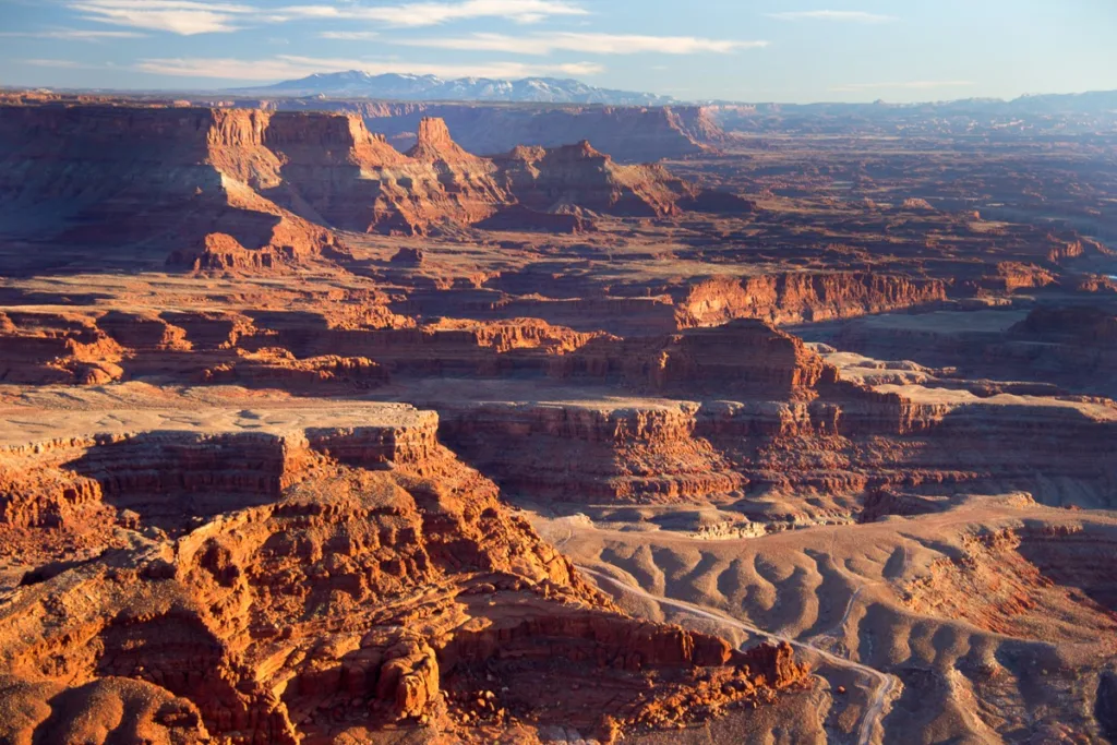
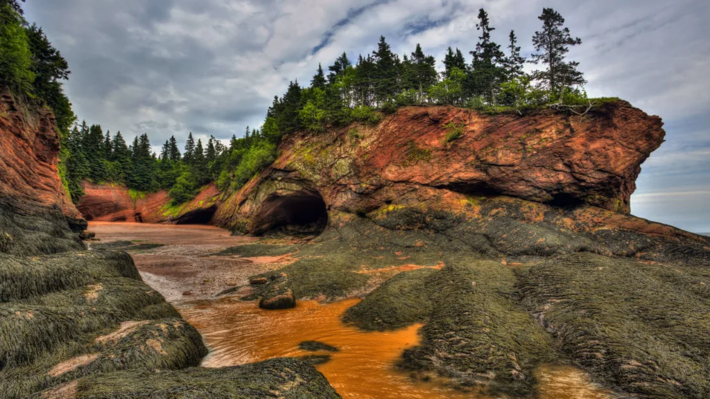
Erosion has played a crucial role in shaping the rock formations found along the shores of the Bay of Fundy. The powerful tidal currents and wave action continuously erode the soft sedimentary rocks, sculpting impressive cliffs, sea stacks, and sea caves. The constant cycle of erosion and deposition has created a dynamic coastal landscape that is ever-changing.

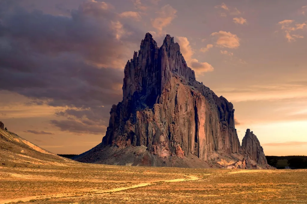
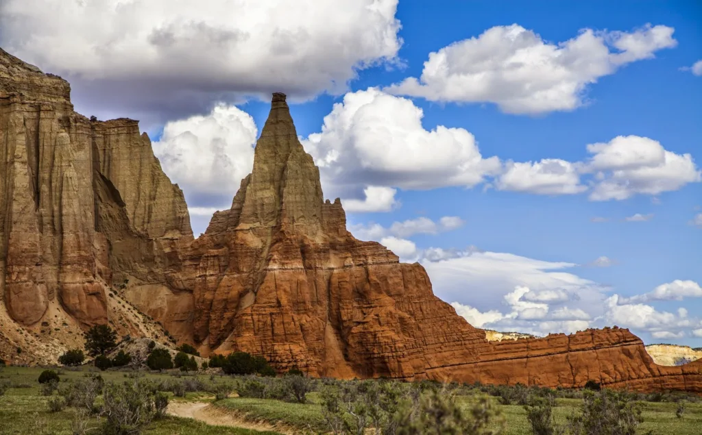
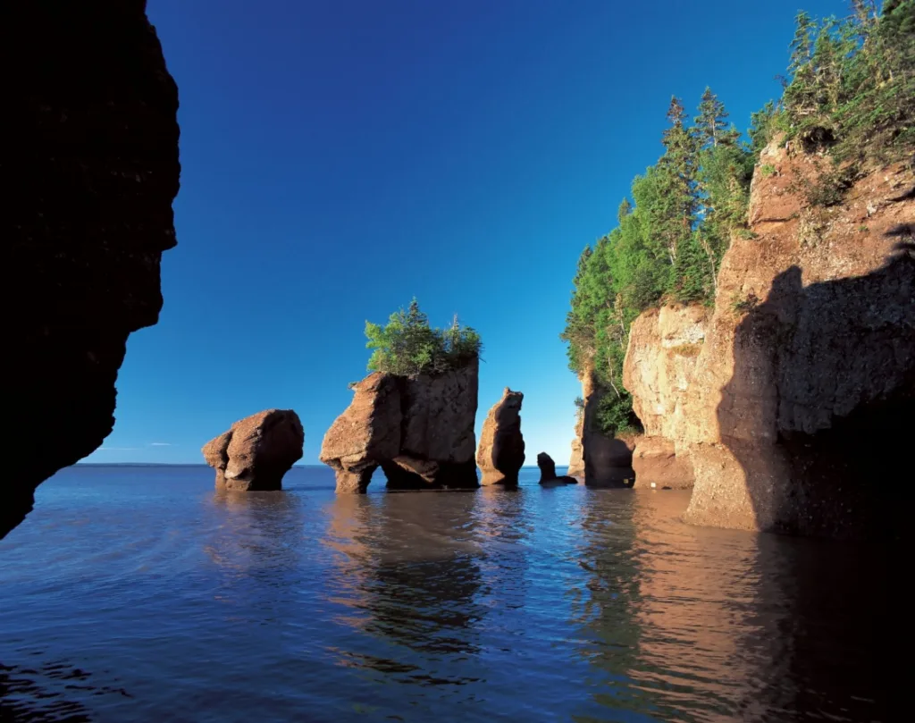
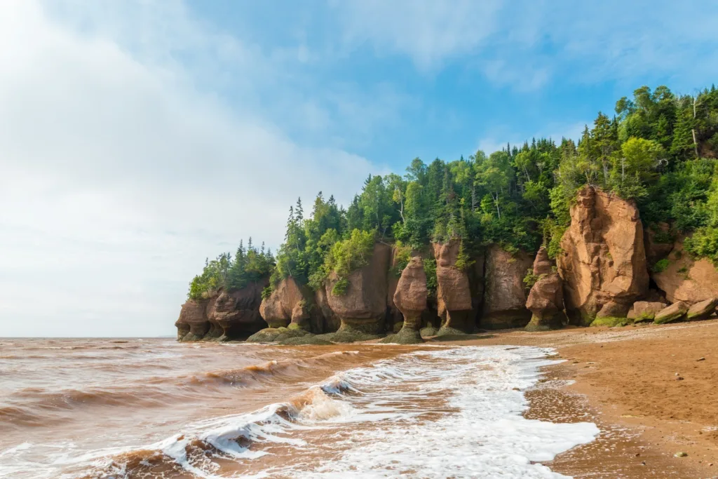
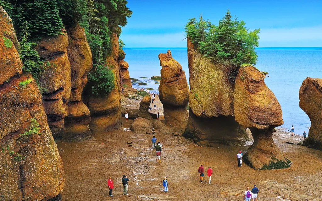
One of the most iconic rock formations in the Bay of Fundy is the Hopewell Rocks, also known as the Flowerpot Rocks. These distinctive formations are composed of sedimentary rocks, primarily sandstone, and were created through the process of differential erosion. The softer upper layers of the rocks have eroded more rapidly than the harder lower layers, resulting in their unique flowerpot-like shapes.

Other notable rock formations in the region include the Three Sisters rock formations in New Brunswick and the towering cliffs of Cape Chignecto in Nova Scotia. These geological features showcase the natural beauty and geological diversity of the Bay of Fundy.

It’s important to note that the geological processes shaping the Bay of Fundy are ongoing. Erosion continues to shape the coastline, and the tides relentlessly interact with the land, ensuring that the region will continue to evolve in the future, creating new geological formations and captivating landscapes.

Tidal Phenomenon in the Bay of Fundy

The Bay of Fundy is renowned for its extraordinary tidal phenomenon, which is considered one of the most dramatic and impressive in the world. The tidal range in the bay is the highest on Earth, resulting in a variety of fascinating tidal phenomena.

The primary factor contributing to the significant tides in the Bay of Fundy is its unique shape and geography. The bay’s narrow and funnel-like form, combined with its increasing width towards the mouth, amplifies the tidal forces, causing the water to rise and fall to remarkable heights.

The tides in the Bay of Fundy are mainly driven by the gravitational pull of the Moon and the Sun, as well as the alignment of the Earth, Moon, and Sun. When these celestial bodies exert their gravitational forces on the Earth, it leads to the formation of two high tides and two low tides per day.

However, in the Bay of Fundy, the resonance of the tides and the bay’s shape cause a phenomenon known as tidal bulge. This results in the tides becoming greatly exaggerated, causing an immense tidal range. During each tidal cycle, the water levels in the bay can rise and fall by as much as 16 meters (53 feet), which is higher than the average two-story building.

One of the remarkable tidal phenomena in the Bay of Fundy is the tidal bore. As the tidal waters rush into the bay, they can create a wave that travels upstream against the current of rivers and estuaries. This wave is called the tidal bore, and its size and power vary depending on the tide and local geography. The tidal bore can be several meters high and is a captivating sight for spectators along the shores.

Another notable tidal phenomenon is the reversing falls, which occur in certain narrow channels and rivers in the Bay of Fundy. During the tidal cycle, the direction of the water flow can reverse due to the tidal forces. As the tides rise, the water can flow upstream, and as the tides recede, the water reverses its flow downstream.

These incredible tidal phenomena have not only shaped the coastline and created unique rock formations but also influenced the ecosystem of the Bay of Fundy. The powerful tidal currents bring nutrient-rich waters that support a diverse marine ecosystem, making the bay a haven for whales, seals, birds, and a wide variety of marine life.

The Bay of Fundy’s tidal phenomenon attracts tourists and researchers alike, offering opportunities for exploration, eco-tourism, and adventure. Visitors can experience the thrill of witnessing the dramatic tides, participate in tidal bore rafting or kayaking, and explore the intertidal zones that are exposed during low tide.

Overall, the tidal phenomenon in the Bay of Fundy is a captivating natural spectacle that showcases the power and beauty of nature, leaving visitors in awe of its grandeur.

Notable Landmarks and Attractions

The Bay of Fundy is home to numerous notable landmarks and attractions that captivate visitors with their natural beauty, rich history, and unique experiences. Here are some of the must-see landmarks and attractions in the region:

  1. Hopewell Rocks: Located in New Brunswick, the Hopewell Rocks, also known as the Flowerpot Rocks, are iconic rock formations shaped by tidal erosion. These towering formations stand at the edge of the bay and offer breathtaking views. During low tide, visitors can walk on the ocean floor and explore the caves and passageways between the rocks.
  2. Fundy National Park: Situated on the coast of New Brunswick, Fundy National Park is a picturesque park encompassing diverse ecosystems, including rugged coastline, dense forests, and sparkling waterfalls. It offers an array of recreational activities such as hiking trails, camping, kayaking, and wildlife spotting. The park provides an opportunity to immerse oneself in the natural beauty of the Bay of Fundy.
  3. Cape d’Or Lighthouse: Located on a dramatic cliff overlooking the bay in Nova Scotia, Cape d’Or Lighthouse offers stunning panoramic views of the coastline. Visitors can take guided tours, learn about the lighthouse’s history, and enjoy the picturesque surroundings.
  4. Cape Enrage: Situated on the New Brunswick side of the bay, Cape Enrage is known for its towering cliffs and rugged beauty. It offers a range of activities, including zip-lining, rock climbing, rappelling, and guided tours. Visitors can also explore the historic lighthouse and take in the breathtaking vistas.
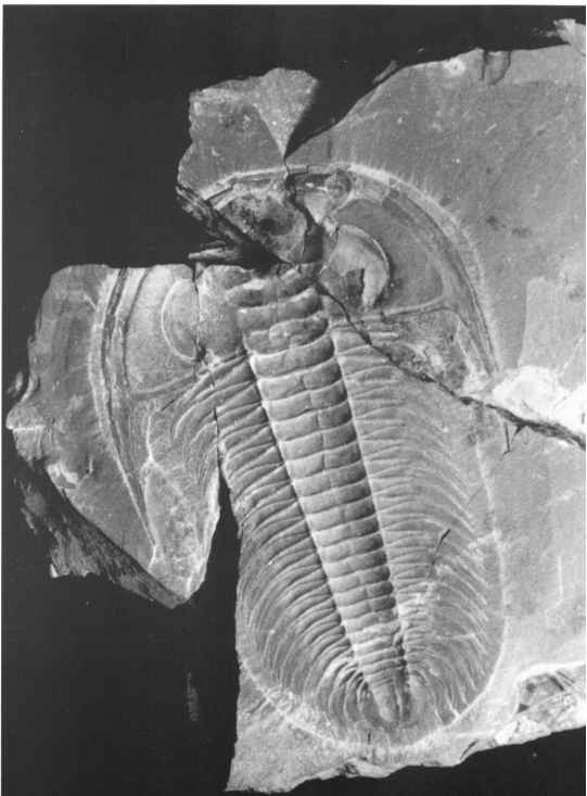
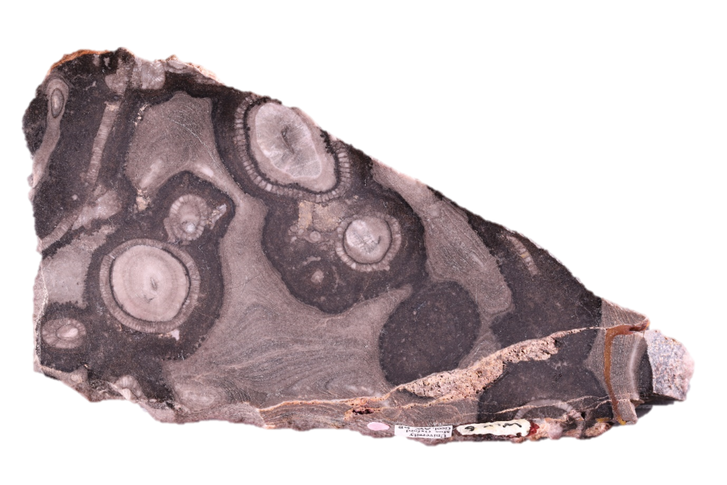
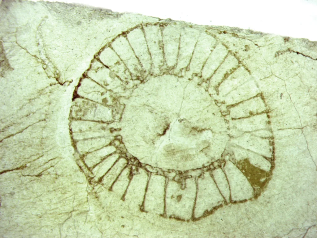
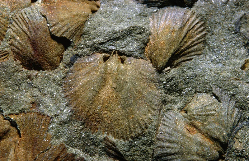
  5. Joggins Fossil Cliffs: Recognized as a UNESCO World Heritage Site, the Joggins Fossil Cliffs in Nova Scotia provide a glimpse into the Earth’s history. The cliffs contain a wealth of fossils, including the world’s largest collection of Carboniferous plant fossils. Guided tours offer insights into the geological significance of the site and the fascinating fossils found there.
  6. Saint John: As the largest city in New Brunswick, Saint John offers a mix of history, culture, and natural beauty. Explore the historic district, visit the New Brunswick Museum, stroll along the waterfront, and experience the famous Reversing Falls, where the tides create a unique natural phenomenon.
  7. Whale Watching: The Bay of Fundy is a prime location for whale watching. Several coastal towns, such as St. Andrews in New Brunswick and Digby in Nova Scotia, offer whale-watching tours where visitors can spot majestic marine mammals like humpback whales, minke whales, and fin whales.

These are just a few examples of the notable landmarks and attractions found in the Bay of Fundy region. Whether you’re interested in exploring the unique rock formations, immersing yourself in nature, or delving into the region’s history and culture, the Bay of Fundy offers a diverse range of experiences that will leave a lasting impression.

References

  1. Government of Canada. (n.d.). Bay of Fundy. Retrieved from https://www.canada.ca/en/environment-climate-change/services/great-lakes-protection/oceans-coasts/bay-fundy.html
  2. Atlantic Canada Geological Guide. (n.d.). Bay of Fundy. Retrieved from http://www.atlanticgeology.com/fundygde.htm
  3. The Canadian Encyclopedia. (n.d.). Bay of Fundy. Retrieved from https://www.thecanadianencyclopedia.ca/en/article/bay-of-fundy
  4. Nova Scotia Tourism Agency. (n.d.). The World’s Highest Tides. Retrieved from https://www.novascotia.com/see-do/nature/worlds-highest-tides
  5. Parks Canada. (n.d.). Fundy National Park – Natural Wonders. Retrieved from https://www.pc.gc.ca/en/pn-np/nb/fundy/nature/marais-marsh
  6. The Bay of Fundy Tourism Partnership. (n.d.). Tides. Retrieved from https://bayoffundytourism.com/tides/
  7. Hopewell Rocks. (n.d.). Home. Retrieved from https://www.thehopewellrocks.ca/
  8. Parks Canada. (n.d.). Fundy National Park – Experience Fundy. Retrieved from https://www.pc.gc.ca/en/pn-np/nb/fundy/activ
  9. Cape d’Or Lighthouse. (n.d.). Home. Retrieved from https://capedorlighthouse.ca/
  10. Cape Enrage. (n.d.). Home. Retrieved from https://capeenrage.ca/
  11. Joggins Fossil Cliffs. (n.d.). Home. Retrieved from https://www.jogginsfossilcliffs.net/
  12. Tourism New Brunswick. (n.d.). Saint John. Retrieved from https://www.tourismnewbrunswick.ca/Products/S/Saint-John
  13. Tourism Nova Scotia. (n.d.). Whale Watching. Retrieved from https://www.novascotia.com/explore/outdoor-activities/whale-watching

Seongsan Ilchulbong Tuff Cone, Jeju Island, Korea

Seongsan Ilchulbong, also known as Seongsan Sunrise Peak or Seongsan Ilchulbong Tuff Cone, is a remarkable volcanic formation located on Jeju Island in South Korea. It is one of the most popular tourist destinations on the island and has been designated as a UNESCO World Heritage Site.

Seongsan Ilchulbong was formed around 5,000 years ago through a series of volcanic eruptions. The volcanic activity resulted in the creation of a large crater at the summit, giving the peak its distinctive shape and appearance. The word “Ilchulbong” translates to “Sunrise Peak,” and it earned this name due to the breathtaking sunrise views it offers from the summit.

The cone-shaped hill rises 182 meters (600 feet) above sea level and is surrounded by the ocean, creating a stunning coastal landscape. The sides of the peak are covered with lush vegetation, creating a beautiful contrast against the dark volcanic rock.

To reach the summit, visitors can follow a well-maintained trail that winds its way up the hillside. The climb takes approximately 30 minutes and is relatively moderate, making it accessible to people of various fitness levels. Along the way, there are designated resting spots where visitors can catch their breath and admire the panoramic views of the surrounding landscape.

At the top of Seongsan Ilchulbong, visitors are greeted with a breathtaking sight. The volcanic crater, known as “Seongsanpo,” is filled with vibrant green grass and is surrounded by jagged cliffs that drop down into the ocean. The view from the summit is especially mesmerizing during sunrise when the first rays of light illuminate the peak, creating a magical atmosphere.

Apart from its natural beauty, Seongsan Ilchulbong also offers cultural and educational experiences. The area surrounding the peak is home to a small village where visitors can explore traditional Jeju-style houses, sample local cuisine, and learn about the island’s rich history and culture.

In conclusion, Seongsan Ilchulbong Tuff Cone is a stunning natural attraction on Jeju Island, offering visitors the opportunity to witness a unique volcanic formation and experience breathtaking sunrise views. Its natural beauty, combined with its cultural significance, makes it a must-visit destination for travelers to South Korea.

Formation and Geological Features

Seongsan Ilchulbong Tuff Cone is a volcanic formation that was created through a series of volcanic eruptions. Here are some details about its formation and geological features:

  1. Volcanic Origins: Seongsan Ilchulbong is part of the larger volcanic landscape of Jeju Island, which is an island formed by volcanic activity. The island itself is a volcanic shield, created by a hotspot beneath the Earth’s crust. The eruptions that formed Seongsan Ilchulbong occurred around 5,000 years ago.
  2. Tuff Cone: Seongsan Ilchulbong is classified as a tuff cone, also known as a volcanic tuff ring or maar. A tuff cone is a type of volcanic landform that is formed when explosive volcanic eruptions interact with water or wet sediment. The eruptions produce ash, rock fragments, and other volcanic materials that accumulate around the vent, forming a conical shape.
  3. Crater and Summit: The most prominent feature of Seongsan Ilchulbong is its large crater, known as “Seongsanpo.” This crater is located at the summit of the tuff cone and is approximately 600 meters in diameter. The crater is relatively flat and is covered with lush green grass, creating a striking contrast against the surrounding volcanic rock.
  4. Cliffs and Surrounding Ocean: The sides of Seongsan Ilchulbong are characterized by steep cliffs that drop down into the ocean. These cliffs are made up of layers of volcanic ash, tuff, and hardened lava flows. The combination of the dramatic cliffs and the deep blue ocean creates a visually stunning landscape.
  5. Basalt Rock Formations: The volcanic rock that comprises Seongsan Ilchulbong is primarily basalt. Basalt is a type of volcanic rock that is formed from the solidification of lava flows. It is dark in color and typically has a fine-grained texture. The basalt formations at Seongsan Ilchulbong add to the rugged and unique appearance of the tuff cone.
  6. Coastal Erosion: Over time, the coastal environment has played a role in shaping the landscape of Seongsan Ilchulbong. The action of waves, wind, and erosion has sculpted the cliffs and contributed to the overall shape and features of the tuff cone.

Seongsan Ilchulbong’s formation and geological features make it a fascinating natural site, attracting visitors who are interested in its volcanic origins and the unique landscape it offers.

UNESCO World Heritage Site

Seongsan Ilchulbong Tuff Cone, also known as Seongsan Sunrise Peak, is a designated UNESCO World Heritage Site. It received this prestigious status in 2007 as part of the Jeju Volcanic Island and Lava Tubes World Heritage Site.

The Jeju Volcanic Island and Lava Tubes site is a collection of geological features on Jeju Island that showcases the island’s volcanic activity and its impact on the landscape. It encompasses various volcanic formations, including Seongsan Ilchulbong, lava tubes, and other volcanic landforms.

The UNESCO designation recognizes the outstanding universal value of the site and its significance in terms of Earth’s geological history and natural heritage. Seongsan Ilchulbong, as a tuff cone, represents a unique and well-preserved example of volcanic landforms, providing insights into the geological processes and the interaction between volcanic activity and the surrounding environment.

Being a UNESCO World Heritage Site brings international recognition and protection to Seongsan Ilchulbong. It highlights the importance of preserving and conserving this natural wonder for future generations. It also promotes tourism and raises awareness about the significance of the site, attracting visitors from around the world to experience its exceptional beauty and geological significance.

As a result of its UNESCO status, efforts are made to manage and sustainably develop the site, balancing tourism activities with conservation measures to ensure its long-term preservation. Interpretive facilities, visitor centers, and educational programs are established to enhance visitors’ understanding of the geological heritage and promote responsible tourism practices.

Overall, the UNESCO World Heritage Site designation underscores the exceptional value and significance of Seongsan Ilchulbong Tuff Cone and its role in preserving and showcasing Earth’s geological history on Jeju Island.

FAQ

How do I get to Seongsan Ilchulbong Tuff Cone?

Seongsan Ilchulbong is located on Jeju Island in South Korea. You can reach Jeju Island by air or ferry from various locations in South Korea. From Jeju City, you can take a bus or taxi to Seongsan Ilchulbong.


Is there an entrance fee to visit Seongsan Ilchulbong?

Yes, there is an entrance fee to visit Seongsan Ilchulbong. The fee may vary, so it’s best to check the current rates before your visit.


What is the best time to visit Seongsan Ilchulbong?

The best time to visit Seongsan Ilchulbong is early morning to witness the breathtaking sunrise from the summit. However, the site is open throughout the day, so you can visit at any time that suits you.


How long does it take to climb to the summit?

It takes approximately 30 minutes to climb to the summit of Seongsan Ilchulbong. The trail is well-maintained and of moderate difficulty.


Can I visit Seongsan Ilchulbong during sunset?

While sunrise is particularly recommended, you can also visit Seongsan Ilchulbong during sunset. The site offers stunning views at different times of the day.


Are there any facilities or amenities available at Seongsan Ilchulbong?

Yes, there are facilities at the site, including restrooms, snack shops, and souvenir shops. There are also seating areas along the trail for visitors to take a break.


Are there any restrictions or rules for visitors?

Visitors are advised to stay on designated trails and follow any instructions provided by park staff. Drone flying is not allowed, and littering is strictly prohibited.


Are there guided tours available at Seongsan Ilchulbong?

Yes, guided tours are available for visitors who prefer a more structured experience. Local tour operators offer guided hikes with knowledgeable guides who provide information about the site’s geological and cultural significance.


Can I bring my own food and drinks?

Yes, you can bring your own food and drinks to enjoy at Seongsan Ilchulbong. However, please be mindful of disposing of any waste properly.


Are there accommodations available near Seongsan Ilchulbong?

Yes, there are accommodations available in the nearby Seongsan-eup area. You can find a range of hotels, guesthouses, and resorts to suit different budgets and preferences.

Paradoxides Pinus

Paradoxides pinus is a species of trilobite, an extinct marine arthropod that lived during the Cambrian period, approximately 540 million years ago. Trilobites were one of the most diverse and abundant groups of organisms during this time.

Paradoxides pinus is specifically classified within the genus Paradoxides, which includes several species of trilobites. Trilobites are characterized by their segmented bodies, with a distinctive three-lobed shape that gives them their name. They had a hard exoskeleton and multiple pairs of legs, making them well-adapted for life on the seafloor.

Paradoxides pinus, like other trilobites, had a flattened body divided into three major sections: the head (cephalon), the thorax, and the tail (pygidium). The head region contained the eyes and various sensory organs, while the thorax and pygidium consisted of multiple segments. Trilobites such as Paradoxides pinus likely inhabited shallow marine environments and played important roles in the ecosystem as both predators and scavengers.

The specific name “pinus” likely refers to the pinecone-like appearance of the pygidium, which is typically adorned with spines or other structures. Trilobite species within the genus Paradoxides are known for their large size, with some individuals of Paradoxides pinus reaching lengths of over 30 centimeters (12 inches).

Paradoxides pinus and other trilobites became extinct around the end of the Permian period, approximately 252 million years ago, during a mass extinction event known as the Permian-Triassic extinction. Despite their extinction, trilobites have left behind a rich fossil record, providing valuable insights into the early history of life on Earth. Fossils of Paradoxides pinus and other trilobite species can be found in various locations around the world, including North America, Europe, and Asia.

Paradoxides pinus geologic importance

Paradoxides pinus and other species of trilobites, including those within the Paradoxides genus, hold significant geologic importance for several reasons:

  1. Biostratigraphy: Trilobites, including Paradoxides pinus, are widely used in biostratigraphy, which is the study of the relative ages of rock layers based on the fossils they contain. Trilobite fossils are excellent index fossils, meaning they are easily recognizable and widespread, allowing geologists to correlate and date rock formations across different regions. Paradoxides pinus, in particular, has been used as a key marker species for defining specific intervals within the Cambrian period.
  2. Paleoenvironmental Reconstructions: The presence of Paradoxides pinus fossils in a particular rock layer provides important clues about the paleoenvironment in which they lived. By studying the sedimentology, depositional environment, and associated fossils, geologists can infer information about ancient oceanic conditions, such as water depth, temperature, and the presence of other organisms. Paradoxides pinus, being a trilobite, indicates a marine environment and can contribute to understanding Cambrian marine ecosystems.
  3. Evolutionary Studies: Trilobites, including Paradoxides pinus, are crucial for understanding the early evolution of arthropods and the diversification of life during the Cambrian explosion. The well-preserved trilobite fossils, with their intricate exoskeletons and anatomical details, provide insights into the morphological adaptations and evolutionary relationships of ancient arthropods. Paradoxides pinus, with its large size and distinct features, contributes to our understanding of the diversity and paleobiology of trilobites during the Cambrian period.
  4. Geological Time Scale: Trilobites, including Paradoxides pinus, have played a fundamental role in establishing and refining the geologic time scale. The presence of specific trilobite species within well-defined rock layers allows for precise dating and correlation of different geological formations. Paradoxides pinus has been used as a biostratigraphic marker to define certain zones within the Cambrian period, aiding in the subdivision and understanding of Earth’s history.

Overall, the presence and study of Paradoxides pinus fossils provide valuable information for reconstructing ancient environments, refining the geologic time scale, and enhancing our knowledge of early arthropod evolution during the Cambrian period.

Paradoxides pinus index fossil

Paradoxides pinus is considered an important index fossil for the Middle Cambrian period. Index fossils are species that have a relatively short existence but were geographically widespread. They are used by geologists and paleontologists to date and correlate rock layers in different locations.

Paradoxides pinus is particularly useful as an index fossil because it has a well-defined and recognizable morphology. Its large size, distinctive three-lobed shape, and the presence of spines or structures on the pygidium make it easily identifiable. These characteristics allow geologists to confidently identify and date the rock layers in which Paradoxides pinus fossils are found.

The widespread distribution of Paradoxides pinus across different regions further enhances its value as an index fossil. Fossils of Paradoxides pinus have been discovered in North America, Europe, and Asia, providing a basis for correlation and dating of rock formations in these areas. The presence of Paradoxides pinus in a particular rock layer indicates that it belongs to the Middle Cambrian period.

By using Paradoxides pinus as an index fossil, geologists can determine the relative ages of rocks in different locations and establish a temporal framework for understanding the geologic history of the Middle Cambrian. This, in turn, allows for the interpretation of paleoenvironments, the study of evolution during this time period, and the refinement of the geologic time scale.

FAQs

What does Paradoxides pinus look like?
Paradoxides pinus is a trilobite with a distinct three-lobed shape. It has a flattened body divided into three major sections: the head (cephalon), the thorax, and the tail (pygidium). The head region contains the eyes and various sensory organs, while the thorax and pygidium consist of multiple segments. Paradoxides pinus is known for its large size, with some individuals reaching lengths of over 30 centimeters (12 inches). The pygidium often bears spines or other structures, resembling a pinecone.

When did Paradoxides pinus live?
Paradoxides pinus lived during the Cambrian period, approximately 540 million years ago. It is specifically classified within the Middle Cambrian, which is a subdivision of the Cambrian period.

Where have Paradoxides pinus fossils been found?
Fossils of Paradoxides pinus have been discovered in various locations around the world. They have been found in North America (including regions such as Newfoundland in Canada), Europe (including Sweden, Norway, and the Czech Republic), and Asia (including China and Kazakhstan).

What is the geologic significance of Paradoxides pinus?
Paradoxides pinus holds significant geologic importance in several ways. It serves as an index fossil, aiding in the dating and correlation of rock layers from the Middle Cambrian period. Paradoxides pinus also contributes to our understanding of paleoenvironments and ancient marine ecosystems during the Cambrian. Additionally, the study of Paradoxides pinus and other trilobites helps in understanding the early evolution of arthropods and refining the geologic time scale.

Are Paradoxides pinus fossils common?
Paradoxides pinus fossils are relatively common in certain regions with well-preserved Cambrian rock formations. However, their abundance can vary depending on the locality and the specific geological conditions that favor fossil preservation.

Are there any living descendants of Paradoxides pinus?
No, Paradoxides pinus and all trilobites are extinct. They became extinct around the end of the Permian period, approximately 252 million years ago.

Can I find Paradoxides pinus fossils myself?
While Paradoxides pinus fossils have been discovered in various locations, finding them yourself can be challenging. It often requires knowledge of the local geology, access to fossil-rich areas, and sometimes permission from landowners or authorities. It’s advisable to connect with local fossil clubs or experts who can provide guidance and assistance in finding trilobite fossils, including Paradoxides pinus.

Archaeocyathids

Archaeocyathids are an extinct group of marine organisms that lived during the early Cambrian period, approximately 541 to 485 million years ago. They are considered to be one of the earliest known forms of multicellular animals and played an important role in the early evolution of life on Earth. Archaeocyathids are classified within the phylum Porifera, which includes modern-day sponges.

Archaeocyathids were sessile organisms, meaning they were attached to the seafloor and did not have the ability to move. They had a unique skeletal structure consisting of calcareous tubes or cones, which formed intricate and often reef-like structures. These structures were composed of multiple chambers connected by pores and channels, and they could grow to considerable sizes, reaching up to several meters in height.

The archaeocyathid body plan was characterized by a central cavity, called the calyx, surrounded by a series of concentric rings or walls. The walls contained numerous small pores that allowed water to flow through the organism for feeding and respiration. It is believed that archaeocyathids were filter feeders, extracting organic particles and nutrients from the water using specialized cells.

The fossil record of archaeocyathids is primarily composed of their skeletal remains, which are often well-preserved due to the calcareous nature of their structures. These fossils provide valuable insights into the ecology and evolution of early marine ecosystems. Archaeocyathids were widely distributed across shallow marine environments, particularly in tropical and subtropical regions, and their fossils have been found on all continents.

The exact biological affinities of archaeocyathids have been a subject of debate among scientists. Some studies suggest that they were early relatives of modern sponges, while others propose that they represent an extinct lineage that occupied a unique evolutionary position. Regardless, archaeocyathids played a significant role in the early development of complex life forms, and their decline and eventual extinction are thought to be linked to environmental changes and competition with other organisms.

Studying archaeocyathids provides valuable insights into the early diversification of animal life and the ancient marine ecosystems of the Cambrian period. Their fossils serve as important markers for dating and correlating rock formations, aiding in the understanding of Earth’s geological history and the emergence of complex life forms.

Archaeocyathids Geological time period (Cambrian)

Archaeocyathids, as mentioned earlier, existed during the Cambrian period, which lasted from approximately 541 to 485 million years ago. Now let’s discuss the importance of archaeocyathids in paleontological research:

  1. Early Animal Evolution: Archaeocyathids represent one of the earliest known forms of multicellular animals, providing valuable insights into the early evolution of complex life forms on Earth. Their existence during the Cambrian period, known for the “Cambrian explosion” of diverse animal life, highlights their role in the early development of animal biodiversity.
  2. Evolutionary Relationships: Archaeocyathids occupy a significant position in the evolutionary tree of life. Although their exact biological affinities are still debated, they are generally considered to be related to modern-day sponges within the phylum Porifera. The study of archaeocyathids helps scientists understand the relationships between early animal groups and their evolutionary trajectories.
  3. Ecological Interactions: The fossilized structures of archaeocyathids provide valuable information about ancient marine ecosystems during the Cambrian period. The reef-like structures created by archaeocyathids served as habitats for other organisms and influenced local biodiversity. By studying these structures, scientists gain insights into ecological interactions, including predator-prey relationships and the interplay between different species.
  4. Environmental Reconstruction: The presence of archaeocyathids in the fossil record helps paleontologists reconstruct ancient environments. These organisms were primarily marine and preferred shallow, warm-water environments. The distribution of archaeocyathid fossils across different regions provides clues about paleogeography and ancient sea levels during the Cambrian period.
  5. Stratigraphic Markers: The occurrence of archaeocyathids in specific rock layers serves as an important stratigraphic marker. These fossils can be used to date and correlate sedimentary rocks, assisting in the establishment of regional and global geological timescales. The presence or absence of archaeocyathids in a particular rock unit helps geologists understand the relative ages and relationships of different sedimentary sequences.

In summary, archaeocyathids hold significance in paleontological research as they provide insights into early animal evolution, evolutionary relationships, ancient marine ecosystems, and environmental reconstructions. Their fossils aid in the dating and correlation of rock formations, contributing to our understanding of Earth’s geological history during the Cambrian period.

Archaeocyathids Fossil Record and Geological Significance

The fossil record of archaeocyathids holds great geological significance and provides valuable insights into Earth’s history. Here’s a closer look at the fossil record and the geological significance of archaeocyathids:

  1. Stratigraphy and Relative Dating: Archaeocyathid fossils are important for stratigraphic correlation and relative dating of rock formations. These fossils have distinct ranges in time, allowing paleontologists to identify specific intervals within the geological record. By examining the presence or absence of archaeocyathids in different sedimentary layers, scientists can establish relative ages and create stratigraphic sequences.
  2. Paleoenvironmental Reconstruction: The presence of archaeocyathids in the fossil record helps reconstruct ancient marine environments. These organisms were primarily reef builders, and their fossils provide evidence of past reef structures. By analyzing the distribution and characteristics of archaeocyathid reefs, scientists can infer paleoenvironmental conditions such as water depth, temperature, and nutrient availability during the Cambrian period.
  3. Paleogeography and Tectonic Reconstructions: Archaeocyathids have a limited geographic distribution, and their fossils can be used to reconstruct past paleogeographic maps. The occurrence of archaeocyathids in different regions helps scientists understand the connectivity and separations of ancient landmasses during the Cambrian period. This information contributes to our understanding of plate tectonics and the movement of Earth’s continents.
  4. Biostratigraphy and Chronostratigraphy: The presence of archaeocyathids in specific sedimentary layers allows for biostratigraphic and chronostratigraphic correlations. By identifying and dating the fossils, scientists can establish the relative ages of rocks and develop a regional or global geological timescale. This information helps in understanding the temporal relationships of different geological events and the evolution of life during the Cambrian period.
  5. Evolutionary Significance: Archaeocyathids represent an early branch of animal evolution and provide important data on the diversification and evolution of early marine life. The study of archaeocyathids helps fill gaps in our knowledge of early animal evolution, providing insights into the origins and relationships of different animal groups.

In summary, the fossil record of archaeocyathids plays a crucial role in geological research. It aids in stratigraphic correlation, paleoenvironmental reconstructions, paleogeographic analyses, and the development of geological timescales. Additionally, the fossils contribute to our understanding of early animal evolution and the history of life on Earth during the Cambrian period.

FAQ

What are archaeocyathids?
Archaeocyathids are extinct marine organisms that lived during the early Cambrian period, approximately 541 to 485 million years ago. They are considered one of the earliest known multicellular animals and are classified within the phylum Porifera, which includes modern-day sponges.

What did archaeocyathids look like?
Archaeocyathids had a unique skeletal structure composed of calcareous tubes or cones. They formed intricate and often reef-like structures, with multiple chambers connected by pores and channels. The structures could reach several meters in height.

Where were archaeocyathids found?
Archaeocyathids were widely distributed in shallow marine environments during the Cambrian period. Fossils of archaeocyathids have been discovered on all continents, indicating a global presence.

What was the ecological role of archaeocyathids?
Archaeocyathids were sessile organisms, meaning they were attached to the seafloor and could not move. They were filter feeders, extracting organic particles and nutrients from the water using specialized cells. Their reef-like structures provided habitats for other organisms, influencing local biodiversity and ecological interactions.

What is the significance of archaeocyathids in understanding early animal evolution?
Archaeocyathids hold importance in the study of early animal evolution. They represent one of the earliest known forms of multicellular animals and provide insights into the early development of complex life forms during the Cambrian period. By studying archaeocyathids, scientists can better understand the origins and relationships of different animal groups.

What led to the extinction of archaeocyathids?
The exact reasons for the extinction of archaeocyathids are still debated. Environmental changes, such as shifts in sea level, ocean chemistry, and competition with other organisms, are among the factors believed to have contributed to their decline and eventual extinction.

How are archaeocyathids studied by paleontologists?
Paleontologists study archaeocyathids by examining their fossilized remains. This involves careful collection, preparation, and analysis of the fossils. The fossil record of archaeocyathids provides valuable information about their morphology, ecology, and evolutionary relationships.

Can archaeocyathids be found in museums?
Yes, fossils of archaeocyathids can be found in museum collections worldwide. Museums with extensive paleontological collections often have displays or exhibits featuring archaeocyathid fossils, allowing visitors to learn about these ancient organisms and their significance in Earth’s history.

Brachiopods

Group of fossil brachiopods, Dalmanella sp., from the Ordovician Period (approximately 500-435 million years ago). Brachiopods are sessile marine invertebrates which have a bivalve shell and bear a number of ciliated tentacles around the mouth. The shell resembles that of a bivalve mollusc but the structure of the body is quite different and the animals are placed in a separate phylum, the Brachiopoda. Brachiopods were very common in Palaeozoic and Mesozoic times, but only a few species survive today. This specimen was found in the Acton Scott series of sediments.

Brachiopods, often referred to as “lampshells,” are a group of marine invertebrates that have existed on Earth for over half a billion years. They are members of the phylum Brachiopoda and are considered one of the oldest known animal groups, with a rich fossil record stretching back to the early Cambrian period.

Brachiopods have a unique anatomy that sets them apart from other marine organisms. They possess a bivalve shell composed of two halves, known as valves, which are hinged together at the dorsal side. The shells are made of calcium carbonate and provide protection for the soft-bodied animal inside. Unlike mollusks such as clams and mussels, to which they are often compared, brachiopods have a distinctive internal anatomy.

The body of a brachiopod is divided into two main parts: the upper lophophore and the lower pedicle. The lophophore is a feeding structure that consists of a ring of tentacles surrounding the mouth. These tentacles are equipped with cilia that generate water currents to bring in food particles, which the brachiopod filters and consumes. The pedicle, located on the lower side of the body, is a fleshy stalk that allows the brachiopod to attach itself to the seafloor or other surfaces.

Brachiopods exhibit a wide range of sizes, shapes, and ecological adaptations. They can be found in both shallow and deep marine environments, from tropical reefs to cold polar waters. Some species live as solitary individuals, while others form colonies or attach themselves to hard substrates. Brachiopods are filter feeders, extracting nutrients from the water column using their lophophores.

During their long evolutionary history, brachiopods experienced periods of abundance and diversity, particularly during the Paleozoic era. They played a significant ecological role as filter feeders and were often important components of ancient marine ecosystems. However, their abundance declined significantly after the Permian-Triassic mass extinction event, and today, they represent a relatively minor group in terms of overall biodiversity.

Despite their reduced diversity, brachiopods continue to thrive in oceans worldwide, with several hundred living species known today. They are valuable to paleontologists as indicators of ancient environments and important fossils for studying Earth’s history. Brachiopods have also been used in biostratigraphy, the dating and correlation of rock layers based on their fossil content.

In summary, brachiopods are ancient marine invertebrates with a bivalve shell, a lophophore for feeding, and a pedicle for attachment. Although their diversity has declined over time, they remain an intriguing group of organisms that provide valuable insights into the evolution and ecology of Earth’s past.

Fossil record and geological history

The fossil record of brachiopods is exceptionally rich and spans a vast period of geological history. Brachiopod fossils can be found in rocks from the early Cambrian period, which began around 541 million years ago, all the way up to the present day. This extensive fossil record provides valuable information about the evolution, diversity, and distribution of brachiopods over time.

During the early Paleozoic era, from the Cambrian to the Permian periods, brachiopods thrived and exhibited remarkable diversity. They were one of the most abundant and widespread groups of marine organisms during this time, with numerous species occupying a wide range of ecological niches. Brachiopods played crucial roles in ancient marine ecosystems as filter feeders, contributing to the cycling of nutrients and energy.

The Paleozoic era saw several major diversification events for brachiopods. For example, during the Ordovician period (around 485 to 443 million years ago), brachiopods underwent a rapid radiation and became dominant in many marine environments. They continued to diversify throughout the Silurian and Devonian periods.

The Carboniferous period (around 359 to 299 million years ago) marked another significant period for brachiopods. They were particularly abundant in shallow marine environments and formed extensive fossil-rich limestone deposits in some regions. However, towards the end of the Carboniferous and into the Permian period, brachiopods experienced a decline in diversity and abundance.

The Permian-Triassic mass extinction event, which occurred approximately 252 million years ago, had a profound impact on brachiopods. It was one of the most devastating mass extinctions in Earth’s history, wiping out around 96% of marine species, including many brachiopod lineages. This event marked a major turning point in the history of brachiopods, leading to a significant decline in their diversity and ecological importance.

After the mass extinction, brachiopods never fully recovered their former dominance. However, they managed to survive and persisted into the Mesozoic era and beyond. During the Mesozoic, brachiopods continued to evolve, but their diversity remained relatively low compared to their Paleozoic peak. They occupied various marine environments, including reefs, seafloors, and even deep-sea habitats.

Brachiopods persisted through the Cenozoic era, which began around 66 million years ago and continues to the present day. Although their diversity continued to decline, they still managed to adapt to different environments and have left a trace in the fossil record.

Today, brachiopods are a relatively minor group of marine invertebrates compared to other organisms such as mollusks. They are represented by a few hundred living species, most of which inhabit deep-sea environments. Nonetheless, the fossil record of brachiopods remains a valuable resource for understanding the history of life on Earth, providing important insights into ancient environments, biogeography, and evolutionary patterns.

Morphology and Anatomy of Brachiopods

The morphology and anatomy of brachiopods are unique among marine invertebrates. Here are the key features and structures that characterize these fascinating organisms:

  1. Bivalve Shell: Brachiopods possess a bivalve shell consisting of two symmetrical valves. The valves are typically composed of calcium carbonate and are hinged together dorsally. Unlike the shells of mollusks, the valves of brachiopods are unequal in size and shape. The ventral (lower) valve tends to be larger and deeper, while the dorsal (upper) valve is smaller and flatter.
  2. Lophophore: Brachiopods possess a lophophore, a specialized feeding structure. The lophophore is a ring-shaped or horseshoe-shaped organ that surrounds the mouth. It is composed of numerous tentacles covered in cilia. The cilia generate water currents that bring in food particles from the surrounding water. The lophophore is extended outside the shell through a small opening known as the orifice.
  3. Pedicle: Brachiopods have a muscular stalk-like structure called the pedicle, located on the ventral side of the body. The pedicle is used for attachment to the seafloor or other substrates. It can be extended or retracted, allowing the brachiopod to adjust its position and orientation.
  4. Mantle: Brachiopods have a mantle, a soft tissue layer that lines the inner surface of the valves. The mantle is responsible for secreting the shell material and maintaining its growth. It also plays a role in respiration and waste elimination.
  5. Digestive System: Brachiopods have a simple digestive system. Food particles collected by the lophophore tentacles are transported to the mouth and then pass into the stomach. From there, the nutrients are absorbed and distributed throughout the body.
  6. Nervous System: Brachiopods possess a decentralized nervous system. They have a ganglion, a cluster of nerve cells, located near the mouth. From the ganglion, nerves extend to various parts of the body, allowing for sensory perception and coordination of basic physiological functions.
  7. Reproductive System: Brachiopods are dioecious, meaning they have separate male and female individuals. The reproductive organs are located within the body cavity. Fertilization occurs internally, and most brachiopods release their eggs and sperm into the water, where external fertilization takes place. Some species brood their fertilized eggs inside the body cavity.
  8. Muscles and Adductor System: Brachiopods have specialized muscles that control the opening and closing of the valves. The adductor muscles, located near the hinge, enable the brachiopod to tightly close its valves for protection.

It’s important to note that the morphology and anatomy of brachiopods can vary among different species. They display a range of sizes, shapes, and adaptations to different ecological niches. These general characteristics provide an overview of the typical structures and functions observed in brachiopods.

Famous brachiopod fossil sites

There are several famous fossil sites around the world known for their abundant brachiopod fossils. These sites have provided significant insights into the evolutionary history and paleoecology of brachiopods. Here are a few notable examples:

  1. Burgess Shale (Canada): Located in the Canadian Rockies in British Columbia, the Burgess Shale is renowned for its exceptional preservation of soft-bodied organisms from the Cambrian period, including brachiopods. The site has yielded a diverse array of brachiopod fossils, providing important information about their early evolution.
  2. Solnhofen Limestone (Germany): The Solnhofen Limestone, located in Bavaria, Germany, is famous for its exceptionally preserved fossils from the Jurassic period. This site is renowned for the discovery of the iconic Archaeopteryx, a transitional fossil between dinosaurs and birds. Brachiopod fossils, including well-preserved specimens, are also found in the Solnhofen Limestone.
  3. Derbyshire (United Kingdom): The limestone deposits of Derbyshire in the United Kingdom are known for their rich brachiopod fauna from the Carboniferous period. The fossils found in this region provide valuable insights into the diversity and ecology of brachiopods during this time.
  4. Helderberg Group (New York, USA): The Helderberg Group in upstate New York, particularly around the city of Albany, is renowned for its fossil-rich limestone formations from the Devonian period. Brachiopod fossils are abundant in these rocks, showcasing a diverse assemblage of species.
  5. Maotianshan Shale (China): The Maotianshan Shale in Yunnan Province, China, is another famous Lagerstätte (site of exceptional preservation) that has yielded remarkable fossil discoveries. It is known for its well-preserved fossils from the Cambrian period, including brachiopods, trilobites, and other marine organisms.
  6. Ordovician Fossil Beds (United States): Located in the midwestern and northeastern United States, the Ordovician Fossil Beds preserve a diverse array of fossils from the Ordovician period. Fossil-rich limestone formations in places such as Cincinnati, Ohio, and the Mohawk Valley in New York contain numerous brachiopod species.
  7. Silurian Fossiliferous Limestones (Gotland, Sweden): The island of Gotland in Sweden is famous for its Silurian limestone formations, which are renowned for their well-preserved brachiopod fossils. These fossils have played a significant role in understanding the Silurian marine ecosystem and its changes over time.

These sites represent just a few examples of the many fossil localities worldwide where brachiopod fossils can be found. Each site offers unique insights into the ancient history of brachiopods and their importance in past marine ecosystems.

Importance as index fossils and biostratigraphy

Brachiopods have played a crucial role as index fossils in biostratigraphy, which is the branch of geology that uses fossils to date and correlate rock layers. They are valuable indicators of the age and relative stratigraphic position of sedimentary rocks. Here’s why brachiopods are significant in biostratigraphy:

  1. Wide Geographical Distribution: Brachiopods have a global distribution and can be found in various marine environments throughout Earth’s history. This wide distribution makes them useful for correlating rock units across different regions and continents.
  2. Evolutionary Significance: Brachiopods have a long evolutionary history that spans hundreds of millions of years. Different species of brachiopods have appeared, thrived, and gone extinct at specific times in the geological past. By studying the presence and abundance of different brachiopod species in different rock layers, geologists can establish relative age relationships and create biostratigraphic zonations.
  3. Rapid Evolution and Speciation: Brachiopods have exhibited periods of rapid diversification and speciation, particularly during the Paleozoic era. This means that certain groups of brachiopods appeared and flourished within specific time intervals, allowing geologists to recognize and differentiate between different geological ages based on the presence of particular brachiopod species.
  4. Habitat Preference: Different brachiopod species exhibit specific habitat preferences and environmental tolerances. Certain species are associated with particular types of sedimentary environments, such as shallow marine, deep-sea, or reef habitats. By examining the brachiopod assemblages in fossiliferous rocks, geologists can infer the paleoenvironments in which these rocks were deposited, aiding in the reconstruction of ancient ecosystems.
  5. Fossil Abundance and Preservation: Brachiopods are often abundant in the fossil record and can be well-preserved under the right conditions. This abundance and preservation potential make them excellent candidates for studying changes in biodiversity, faunal turnover, and paleoenvironmental shifts through time.

By using brachiopods as index fossils, geologists can establish biostratigraphic zones or units, which are defined by the presence or absence of specific brachiopod taxa. These zones allow for the correlation of rock layers, determining their relative ages and assisting in the construction of geological timelines. Brachiopods, with their rich fossil record and diverse morphological variations, serve as valuable tools for understanding the Earth’s geological history and unraveling the sequence of events that have shaped our planet over millions of years.

FAQs

What is a brachiopod?
A brachiopod is a marine invertebrate belonging to the phylum Brachiopoda. They have a bivalve shell, a lophophore for feeding, and a pedicle for attachment.

How do brachiopods differ from mollusks?
Brachiopods are often confused with mollusks due to their similar bivalve shell appearance. However, brachiopods have a distinct internal anatomy and differ in their feeding structures and evolutionary history.

When did brachiopods first appear on Earth?
Brachiopods have been around for over half a billion years, with their fossil record dating back to the early Cambrian period, around 541 million years ago.

Where can brachiopods be found today?
Brachiopods are primarily found in marine environments worldwide, including both shallow and deep-sea habitats. Most living brachiopod species inhabit cold-water regions.

Are brachiopods extinct?
No, brachiopods are not extinct. While their diversity has declined over time, there are still several hundred living species of brachiopods known today.

What do brachiopods eat?
Brachiopods are filter feeders. They use their lophophore, a feeding structure with tentacles, to filter small particles, such as plankton, from the water.

How do brachiopods reproduce?
Brachiopods are dioecious, meaning there are separate male and female individuals. Most brachiopods release their eggs and sperm into the water, where fertilization occurs externally.

Can you find brachiopod fossils?
Yes, brachiopod fossils are common and can be found in sedimentary rocks worldwide. They are valuable fossils for studying Earth’s history and ancient marine ecosystems.

Are brachiopods related to clams or oysters?
Brachiopods and bivalve mollusks (such as clams and oysters) have similarities in their bivalve shells, but they are not closely related. Brachiopods have a distinct evolutionary history and anatomical features.

What is the significance of brachiopods in paleontology?
Brachiopods are important to paleontologists as indicators of ancient environments, biostratigraphy, and evolutionary patterns. They have a rich fossil record and provide valuable insights into Earth’s past biodiversity and geological history.

Ammonites

Ammonites are among the most beautiful and scientifically valuable fossils on Earth.
Their spiral shells, perfectly preserved in stone, decorate museum halls, cliffs, and fossil beds around the world.
But beyond their aesthetic appeal lies a deeper story — one of evolution, extinction, and the ancient seas that once covered our planet.

Ammonites are extinct marine mollusks that lived from the Devonian to the end of the Cretaceous Period, roughly 400 to 66 million years ago.
They are among the most important index fossils, helping geologists to date and correlate sedimentary rock layers across continents.


What Are Ammonites?

Ammonites belong to the subclass Ammonoidea, part of the larger class Cephalopoda, which also includes modern squid, octopus, and cuttlefish.
Their closest living relative today is the nautilus, a shelled cephalopod that still inhabits tropical seas.

Ammonites had coiled, chambered shells divided by thin walls called septa.
The animal itself lived in the outermost chamber, while the inner chambers were filled with gas or liquid to control buoyancy.
This ability allowed ammonites to move vertically through the water column, much like submarines.

Their name comes from the Egyptian god Ammon, who was often depicted with ram’s horns — resembling the spiral shape of the ammonite shell.


Physical Characteristics and Shell Structure

The ammonite shell is one of nature’s most remarkable designs. It is planispiral (coiled in a single plane), though some groups developed unusual forms, such as uncoiled or irregular shapes known as heteromorphs.

1. Shell Chambers and Suture Lines

Inside each ammonite shell are a series of chambers. The walls separating them — the septa — connect to the outer shell along lines known as sutures.
Suture patterns are key to ammonite classification:

  • Goniatitic: simple wavy sutures (Paleozoic forms)
  • Ceratitic: more complex, frilled sutures (Triassic forms)
  • Ammonitic: highly intricate, tree-like patterns (Jurassic–Cretaceous forms)

These suture lines strengthened the shell, allowing ammonites to withstand high water pressure.

2. Shell Ornamentation

Many species had ribs, ridges, knobs, or spines along the shell surface.
These features likely provided protection from predators and helped stabilize the animal while swimming.
Shell diameter ranged from a few millimeters to more than 2 meters — the largest known species, Parapuzosia seppenradensis, lived in the Late Cretaceous.


How Ammonites Lived

Ammonites were marine carnivores, feeding on small crustaceans, plankton, and other invertebrates.
They used tentacles extending from their soft body to capture prey, much like modern squids.

Their habitats varied from shallow continental shelves to deeper offshore environments.
The presence of certain ammonite species in rock layers helps scientists reconstruct ancient marine ecosystems, ocean depth, temperature, and chemistry.

Predators of ammonites included marine reptiles like mosasaurs, ichthyosaurs, and even large fish.
Many ammonite fossils show bite marks or crushed shells — direct evidence of ancient predation.


The Fossilization of Ammonites

After death, ammonite shells sank to the seafloor and were buried by sediments.
Over millions of years, chemical processes transformed these shells into stone — a process known as fossilization.

Depending on the burial environment, different types of fossils formed:

  • Original aragonite shells may recrystallize into calcite.
  • Casts and molds form when the shell dissolves, leaving a cavity that later fills with minerals such as silica or pyrite.
  • Opalized or iridescent ammonites, found in places like Canada and Madagascar, result from mineral replacement that gives a rainbow-like sheen.

Because ammonites evolved rapidly and spread widely, their fossils are excellent time markers for correlating rock layers (biostratigraphy).


Geological and Scientific Importance

1. Index Fossils and Stratigraphy

Ammonites are the quintessential index fossils — species that existed globally but for relatively short time spans.
Each ammonite species lived for only a few hundred thousand years, making them perfect for dating rock layers.

In the Jurassic and Cretaceous periods, ammonites were so widespread that geologists can now subdivide those eras into smaller biozones, each defined by a specific ammonite species.

2. Evolutionary Insights

Ammonites evolved rapidly, producing a spectacular variety of shell forms.
By studying these changes, paleontologists trace evolutionary trends and adaptation patterns — for example, how shell complexity correlates with water depth or predator pressure.

3. Paleoclimate and Paleogeography

The global distribution of ammonite fossils helps scientists map ancient seas and continental positions.
Differences in shell chemistry (oxygen isotopes) even provide clues to sea temperature and climate fluctuations millions of years ago.


Diversity Through Time

Ammonites first appeared in the Devonian Period (~400 Ma) and diversified spectacularly during the Mesozoic Era — the Age of Reptiles.
Their history can be divided into several major evolutionary phases:

  1. Devonian–Carboniferous: Early goniatitic forms with simple shells.
  2. Permian–Triassic: A mass extinction wiped out most species, but survivors radiated again.
  3. Jurassic: Peak diversity; ammonites of all shapes and sizes thrived in warm epicontinental seas.
  4. Cretaceous: Continued diversification until their sudden extinction at the end of the period (~66 Ma).

By the late Cretaceous, ammonites shared the oceans with marine reptiles and early teleost fishes — a vibrant but fragile ecosystem that collapsed with the asteroid impact.


Extinction of the Ammonites

Like dinosaurs, ammonites perished during the Cretaceous–Paleogene (K–Pg) mass extinction, around 66 million years ago.
This catastrophic event, triggered by a massive asteroid impact in modern-day Mexico, caused severe global cooling, ocean acidification, and food-chain collapse.

Ammonites, which relied on plankton for food and for their larvae, could not survive these rapid environmental changes.
Only their distant cousins, the nautiloids, managed to endure — perhaps due to different reproductive strategies and deeper ocean habitats.

Their extinction marks one of the clearest boundaries in the geologic record.


Ammonites as Index Fossils

Because ammonites evolved quickly and spread across all ancient oceans, their fossils serve as geological clocks.
For example:

  • The presence of Perisphinctes indicates Middle Jurassic deposits (~165 Ma).
  • Baculites fossils identify Late Cretaceous layers (~80 Ma).

By comparing ammonite species in distant rock formations, geologists can synchronize strata across continents, refining the global geologic time scale.


Where Ammonite Fossils Are Found

Ammonite fossils are abundant on every continent, especially in marine sedimentary rocks such as limestone, shale, and chalk.
Some of the most famous collecting sites include:

  • Lyme Regis, England – Jurassic Coast cliffs rich in Arietites and Dactylioceras.
  • Madagascar – beautifully preserved, multicolored ammonites often polished for display.
  • Morocco and Germany – prolific Cretaceous beds with pyritized specimens.
  • Alberta, Canada – home to opalized ammonites known as ammolite gemstones.

These localities provide not just fossils but also insight into ancient ocean environments.


Ammonites in Culture and Gemology

The striking spiral of ammonites has fascinated humans for centuries.
Ancient civilizations viewed them as sacred symbols — the “snakes turned to stone” of medieval Europe or the “stones of Ammon” in Egypt.

Today, polished ammonites are prized by collectors and jewelers.
In particular, ammolite, the iridescent fossilized shell material found in Canada, is classified as an organic gemstone — rare, durable, and visually stunning.

Ammonites also inspire architecture, art, and even mathematical studies of natural spirals (logarithmic curves found in both biology and geometry).


Scientific Study: How Paleontologists Work with Ammonites

Paleontologists use a combination of fieldwork, morphology, and geochemistry to study ammonites:

  1. Field Mapping – recording fossil layers and geological context.
  2. Preparation and Microscopy – removing rock matrix, examining septa and sutures under magnification.
  3. Stable Isotope Analysis – revealing temperature and water conditions from shell composition.
  4. CT-Scanning and 3D Modeling – visualizing internal chamber structures without destroying the fossil.

These methods continue to reveal new insights into ammonite life habits, growth rates, and evolutionary relationships.


Modern Relatives and Legacy

Ammonites may be extinct, but their relatives — nautiluses and squid — keep part of their lineage alive.
Both share similar soft-body anatomy, jet propulsion, and tentacle arrangements.

The study of ammonites also helps biologists understand biomineralization (how organisms produce shells) and evolutionary resilience — how species adapt or fail in the face of environmental stress.


Conclusion

Ammonites are far more than spiral fossils; they are storytellers from Earth’s deep past.
Each fossil represents an individual life that once floated through ancient oceans, lived, hunted, and eventually became part of the planet’s geological memory.

Through their delicate chambers and intricate sutures, ammonites record the rhythms of evolution, extinction, and rebirth — a timeless reminder of how interconnected all life is with the changing Earth.

Their beauty captivates collectors, their structure fascinates scientists, and their legacy endures in the very rocks that shape our world.

Trilobite

Trilobites are a group of extinct marine arthropods that existed for a staggering period of time, spanning over 270 million years. They first appeared during the Early Cambrian period around 521 million years ago and became extinct during the mass extinction event at the end of the Permian period around 252 million years ago. Trilobites are one of the earliest known complex life forms and left behind an extensive fossil record, making them a subject of great interest to paleontologists.

The name “trilobite” originates from their distinctive body structure, which is divided into three distinct longitudinal lobes. These lobes run from the head (cephalon) to the tail (pygidium) and provide the trilobite with a segmented appearance. This segmentation enabled them to have flexible and articulated bodies, allowing for movement and protection.

Trilobites varied greatly in size, ranging from a few millimeters to over two feet in length, depending on the species. They possessed a hard exoskeleton made of calcite, a mineral form of calcium carbonate. This exoskeleton, divided into a series of articulated segments, offered protection to the trilobite’s soft body parts.

The anatomy of trilobites reveals several important features. They had a pair of compound eyes, which were some of the most advanced visual systems of their time. Some trilobite species had remarkably complex eyes, with lenses made up of calcite crystals that provided them with improved vision.

The trilobite’s diet varied based on the species and their habitat. Some were detritivores, feeding on dead organic matter and sediment on the ocean floor. Others were predators, hunting and scavenging for smaller organisms. Trilobites had multiple pairs of legs that they used for locomotion and feeding.

Trilobite fossils are found in various parts of the world, including North America, Europe, Asia, Africa, and Australia. These fossils provide valuable information about ancient marine ecosystems and have helped scientists understand the evolution and diversification of life during the Paleozoic Era.

Studying trilobites has contributed significantly to our understanding of ancient Earth and the processes that shaped life over hundreds of millions of years. Their incredible diversity, abundance, and long evolutionary history make trilobites fascinating subjects of scientific research and a captivating window into the ancient past.

Trilobite Anatomy and Morphology

Trilobites exhibit a wide range of anatomical features and morphological adaptations that allowed them to thrive in various marine environments. Let’s explore their anatomy and morphology in more detail:

  1. Exoskeleton: Trilobites had a hard exoskeleton composed of calcium carbonate, providing protection for their soft body parts. The exoskeleton was divided into distinct segments, allowing for flexibility and movement. The exoskeleton was periodically molted as the trilobite grew.
  2. Cephalon: The head of a trilobite, known as the cephalon, was the most differentiated region of their body. It featured compound eyes, which were often large and prominent. The number and arrangement of lenses in the eyes varied among different trilobite species.
  3. Thorax: Following the cephalon, trilobites had a segmented body region called the thorax. The number of thoracic segments varied among species and could range from just a few to more than 20. Each thoracic segment had a pair of appendages known as biramous limbs, with one branch for walking and another for feeding.
  4. Pygidium: The pygidium was the posterior part of a trilobite’s body and consisted of several fused segments. It often had a tail spine or a pair of spines for protection and stability. The morphology of the pygidium was highly diverse among different trilobite species.
  5. Sutures: Trilobite exoskeletons were characterized by distinctive patterns of sutures, which were lines of weakness in the exoskeleton where molting occurred. The complexity and arrangement of sutures varied among different trilobite groups and were used as important taxonomic features.
  6. Locomotion: Trilobites had multiple pairs of walking legs attached to their thoracic segments, allowing them to move across the seafloor. The legs were jointed and could be flexed, providing mobility. Some trilobites also possessed specialized appendages for swimming.
  7. Feeding Structures: Trilobites exhibited a range of feeding strategies. Some were filter feeders, using their legs to sweep food particles into their mouths. Others were scavengers or predators, equipped with spiny appendages and sharp mouthparts for capturing and consuming prey.
  8. Reproduction: The reproductive processes of trilobites are not well understood due to the rarity of preserved reproductive organs in the fossil record. However, some specimens have shown evidence of paired structures thought to be associated with reproduction.

It is important to note that trilobite anatomy and morphology varied greatly among different species and across geological time. Their diverse adaptations allowed them to occupy various ecological niches, contributing to their long-lasting success in prehistoric oceans.

Evolution and Diversity of Trilobites

Trilobites exhibit a remarkable evolutionary history and an impressive diversity of forms. Over the course of their existence, they underwent significant evolutionary changes and radiated into numerous species. Here are some key points about the evolution and diversity of trilobites:

  1. Origin and Early Evolution: Trilobites first appeared in the fossil record during the Early Cambrian period, around 521 million years ago. The earliest trilobites were small and had relatively simple body plans. They quickly diversified and spread across various marine environments.
  2. Adaptive Radiation: Trilobites underwent a period of rapid diversification known as adaptive radiation during the Cambrian explosion. They evolved a wide range of forms, sizes, and ecological adaptations, occupying different niches in the oceans. This diversification contributed to their success and dominance during the Paleozoic Era.
  3. Body Plan Variation: Trilobites displayed a diverse array of body shapes, sizes, and ornamentation. Some had smooth exoskeletons, while others had elaborate spines, tubercles, or other ornamentation for protection or display. The number and arrangement of body segments, as well as the shape and size of the cephalon and pygidium, varied among different species.
  4. Paleozoic Fauna: Trilobites were an integral part of the Paleozoic marine ecosystems and coexisted with various other organisms such as brachiopods, crinoids, corals, and early fish. They played important roles as predators, scavengers, and detritivores, contributing to the cycling of nutrients in ancient oceans.
  5. Extinction Events: Trilobites experienced several extinction events throughout their long history. The most significant one occurred at the end of the Permian period, around 252 million years ago, during the largest mass extinction in Earth’s history. This event marked the extinction of the trilobites, along with many other marine and terrestrial species.
  6. Taxonomic Classification: Trilobites are classified into various orders, families, and genera based on their morphological characteristics. These classifications help organize and study the vast diversity of trilobite species. Some notable trilobite orders include the Proetida, Phacopida, Corynexochida, and Agnostida, among others.
  7. Global Distribution: Trilobite fossils have been discovered on all continents, providing valuable insights into the ancient geography and paleoenvironments of Earth. Different regions yielded distinct trilobite faunas, reflecting the geographical separation and evolutionary diversification of these organisms.
  8. Fossil Record: Trilobites have an extensive and well-preserved fossil record, making them one of the most studied groups of extinct organisms. Their fossils provide valuable information about ancient ecosystems, environmental conditions, and the processes of evolution and extinction.

Studying the evolution and diversity of trilobites contributes to our understanding of the Earth’s history, the development of complex life forms, and the dynamics of ancient marine ecosystems. Trilobites serve as important index fossils for dating and correlating rock layers, aiding in the reconstruction of past environments and the unraveling of evolutionary patterns.

Trilobite Paleoenvironments

Trilobites inhabited a wide range of paleoenvironments throughout their long existence, adapting to different marine habitats and ecological conditions. Here are some of the paleoenvironments where trilobites thrived:

  1. Shallow Marine Environments: Many trilobite species inhabited shallow marine environments such as coastal areas, continental shelves, and nearshore zones. These areas were characterized by relatively shallow water depths, abundant sunlight, and diverse ecosystems. Trilobites found in these environments often had adaptations for benthic (bottom-dwelling) lifestyles, feeding on detritus, algae, or other organisms.
  2. Reef Environments: Trilobites were present in reef ecosystems, which were characterized by the growth of diverse coral and sponge communities. They occupied various niches within the reefs, including crevices, burrows, or open spaces. Some trilobite species may have had symbiotic relationships with reef organisms, while others were predators or scavengers within the reef ecosystem.
  3. Deep Marine Environments: Trilobites also inhabited deeper marine environments, such as the continental slope, abyssal plains, and deep-sea basins. In these regions, trilobites adapted to low-light conditions and colder temperatures. They were often associated with soft sediments, where they fed on organic material, scavenged for food, or preyed upon other organisms.
  4. Open Ocean: Trilobites are less common in open oceanic environments, but some species are known to have inhabited pelagic zones. These trilobites were likely strong swimmers and possessed adaptations for an active lifestyle in the water column. They may have fed on plankton or small organisms suspended in the water.
  5. Brackish Water and Estuaries: Trilobites have been found in brackish water and estuarine environments, which are characterized by the mixing of freshwater and seawater. These transitional environments supported unique trilobite communities adapted to changing salinity levels and fluctuations in environmental conditions.
  6. Subtidal and Intertidal Zones: Trilobites could be found in subtidal zones below the water surface as well as intertidal zones exposed during low tides. In the intertidal zone, trilobites may have endured periods of desiccation and adapted to the fluctuating conditions between the marine and terrestrial realms.

The distribution of trilobites across different paleoenvironments provides valuable information about the environmental conditions of the past, such as water depth, temperature, salinity, and nutrient availability. Studying trilobite fossils within their paleoenvironmental context helps paleontologists reconstruct ancient marine ecosystems, understand ecological interactions, and unravel the evolutionary adaptations of these fascinating organisms.

Trilobite Fossilization and Preservation

Trilobites have a remarkable fossilization and preservation potential, which has contributed to the abundance and quality of their fossil record. Here are some key aspects of trilobite fossilization and preservation:

  1. Rapid Burial: For fossilization to occur, a trilobite’s remains typically needed to be rapidly buried by sediment shortly after death. This rapid burial helped protect the organism from scavengers, decay, and physical damage. Fine-grained sediments, such as mud or silt, were particularly conducive to preserving delicate structures.
  2. Soft Tissue Preservation: Trilobite fossils often preserve not only the hard exoskeleton but also traces of soft tissues. In exceptional cases, the impressions of soft body parts like antennae, legs, gills, or even digestive systems can be preserved. These soft tissue impressions provide valuable insights into the anatomy and biology of trilobites.
  3. Calcium Carbonate Preservation: Trilobite exoskeletons were composed of calcium carbonate, which has good preservation potential under certain conditions. In environments with low oxygen levels, such as deep-sea or anoxic settings, the carbonate shells of trilobites could be preserved with remarkable detail.
  4. Replacement and Permineralization: Trilobite fossils often undergo replacement or permineralization, where minerals from the surrounding sediment gradually replace the organic material of the organism. Common minerals involved in replacement include silica, pyrite, and calcite. This process can result in well-preserved and sturdy fossils.
  5. Pyritization: In some cases, trilobite fossils undergo pyritization, where the soft tissues and exoskeleton are replaced by pyrite (iron sulfide). Pyritized trilobites can exhibit exquisite preservation, with intricate details and even the preservation of soft tissues.
  6. Lagerstätten: Trilobites are occasionally found in Lagerstätten, which are exceptionally preserved fossil sites. Lagerstätten often preserve fossils with soft tissues, delicate structures, and even traces of behavior. Some notable Lagerstätten with trilobite fossils include the Burgess Shale in Canada, the Hunsrück Slate in Germany, and the Wheeler Shale in the United States.
  7. Molds and Casts: Trilobite fossils can form molds and casts when the original hard parts dissolve or decay, leaving behind a cavity that is later filled with sediment or minerals. These molds and casts provide a three-dimensional representation of the trilobite’s shape and can be used to study their morphology.
  8. Fossil Associations: Trilobite fossils are often found in association with other organisms, such as brachiopods, crinoids, and bivalves. These associations provide valuable insights into ancient ecological relationships and paleoenvironments.

The exceptional preservation of trilobite fossils has allowed scientists to study their anatomy, morphology, evolutionary relationships, and paleoecology in great detail. Trilobite fossils serve as important tools for understanding Earth’s history and the evolution of life during the Paleozoic Era.

Trilobites in Human Culture and Study

Trilobites have captivated human interest and have been the subject of study, appreciation, and cultural significance. Here are some aspects of trilobites in human culture and study:

  1. Scientific Study: Trilobites have been a focus of scientific research for centuries. They serve as important index fossils, helping geologists date and correlate rock layers and reconstruct ancient environments. Paleontologists study trilobites to understand the evolution, diversity, and paleoecology of these extinct organisms, providing insights into the history of life on Earth.
  2. Collecting and Fossil Trade: Trilobite fossils are highly sought after by collectors, both amateur and professional. Collecting trilobites has become a popular hobby, and enthusiasts often seek out well-preserved specimens to add to their collections. Trilobite fossils are traded and sold in the fossil market, contributing to their wider availability.
  3. Museums and Exhibits: Trilobite fossils are prominently displayed in museums and natural history exhibits around the world. These displays showcase the diversity and beauty of trilobites, providing educational opportunities for visitors to learn about Earth’s ancient history and the process of fossilization.
  4. Art and Design: Trilobites have inspired artists and designers across various mediums. Trilobite motifs and images are often incorporated into jewelry, sculptures, paintings, and other artistic creations. Their intricate exoskeletons and unique forms lend themselves well to aesthetic interpretation and artistic expression.
  5. Symbolism and Iconography: Trilobites have become symbolic of the ancient past and the deep history of life on Earth. They represent resilience, adaptation, and the impermanence of life. Trilobites have appeared in cultural references, logos, and emblems, symbolizing curiosity, exploration, and the wonders of the natural world.
  6. Paleontological Outreach: Trilobites play a significant role in public outreach and education programs organized by museums, universities, and scientific institutions. They are often featured in fossil workshops, guided tours, and educational materials aimed at promoting an understanding of paleontology and Earth’s geological history.
  7. Trilobite Festivals and Events: In certain regions with notable trilobite fossil sites, annual festivals and events celebrate these ancient arthropods. These gatherings bring together scientists, enthusiasts, and the local community to appreciate and learn more about trilobites through exhibitions, lectures, fossil hunts, and other activities.

Trilobites have left a lasting impact on human culture and scientific understanding. Their fossil remains have intrigued and inspired people for centuries, fostering a sense of wonder and curiosity about the ancient past and the evolution of life.

FAQs

What are trilobites?
Trilobites were a diverse group of extinct marine arthropods that lived from the Cambrian to the Permian periods. They had a hard exoskeleton divided into three lobes, hence the name “trilobite.”

When did trilobites exist?
Trilobites lived from approximately 521 to 252 million years ago, spanning a significant portion of the Paleozoic Era.

What did trilobites look like?
Trilobites had a wide variety of body shapes, sizes, and ornamentation. They ranged from a few millimeters to over half a meter in length and featured a head (cephalon), a segmented body, and a tail (pygidium).

What did trilobites eat?
Trilobites had diverse diets. Some were predators that fed on other organisms, while others were detritivores or filter feeders. Some trilobites may have even been herbivorous.

How did trilobites reproduce?
Trilobites had a variety of reproductive strategies. Many species were likely dioecious, with separate male and female individuals. Fertilization was likely external, with males depositing sperm onto the female’s eggs.

What was the purpose of trilobite eyes?
Trilobites had a remarkable array of eye types, ranging from simple to highly complex. Their eyes were likely used for detecting light and forming images, allowing trilobites to navigate their environment and locate prey or avoid predators.

Where are trilobite fossils found?
Trilobite fossils have been found on all continents. Fossil-rich regions include the United States (such as the Wheeler Shale and the Burgess Shale), Canada (such as the Burgess Shale and the Elginia beds), Morocco, China, and the Czech Republic.

How are trilobite fossils formed?
Trilobite fossils are typically formed through the process of fossilization, where the remains of a trilobite are buried in sediment and over time, the organic material is replaced by minerals. This preserves the trilobite’s form and allows it to be fossilized.

Why are trilobite fossils important?
Trilobite fossils are important for understanding Earth’s ancient history. They serve as index fossils, helping geologists date and correlate rock layers. Trilobites also provide insights into past ecosystems, climate, and the evolution of life.

Why did trilobites go extinct?
Trilobites went extinct during the Permian mass extinction event, which occurred around 252 million years ago. The exact reasons for their extinction are still debated, but factors such as changes in sea levels, climate, and the emergence of new predators may have contributed to their decline.

Mývatn Geothermal Area – Iceland

The Mývatn Geothermal Area is a fascinating region located in the north of Iceland. It is renowned for its unique geological features, volcanic landscapes, and abundant geothermal activity. Mývatn, which translates to “Midge Lake,” gets its name from the large number of midges that inhabit the area during the summer months.

One of the defining characteristics of the Mývatn Geothermal Area is its numerous hot springs and geothermal vents, which create a visually stunning and otherworldly environment. These geothermal features are a result of the volcanic activity in the region, as Mývatn sits within the Krafla volcanic system.

The geothermal area offers visitors the chance to witness a wide range of natural wonders. One of the highlights is the Námaskarð geothermal area, known for its colorful and steaming hot mud pots, fumaroles, and sulfur crystals. The landscape here is striking, with vibrant hues of red, yellow, and green contrasting against the barren, rocky terrain.

Another notable attraction in the Mývatn Geothermal Area is the Mývatn Nature Baths, often referred to as the “Blue Lagoon of the North.” These geothermal baths provide visitors with the opportunity to relax and soak in the warm, mineral-rich waters while taking in the stunning surrounding views.

Aside from its geothermal features, the Mývatn region is also a significant site for birdwatching. The lake itself attracts a diverse range of bird species, including several rare and protected ones. Bird enthusiasts flock to Mývatn to catch glimpses of various waterfowl, waders, and migratory birds, making it a paradise for ornithology enthusiasts.

The Mývatn Geothermal Area is easily accessible and is a popular destination for tourists seeking a unique and immersive natural experience. Whether you’re interested in geology, birdwatching, or simply unwinding in soothing geothermal waters, this area offers a wealth of attractions that showcase the raw power and beauty of Iceland’s geothermal activity.

Geothermal features and phenomena

The Mývatn Geothermal Area is known for its diverse range of geothermal features and phenomena. These unique natural formations are a result of the geothermal activity occurring beneath the Earth’s surface. Let’s explore some of the prominent geothermal features found in the region:

  1. Hot Springs: Hot springs are one of the most recognizable geothermal features in the Mývatn area. These are natural pools of hot water that emerge from the ground due to the heating of underground geothermal reservoirs. The water in the hot springs is heated by the geothermal activity and often contains various minerals, giving it a distinct color and therapeutic properties.
  2. Mud Pools: Mud pools, also known as mud pots, are fascinating geothermal features found in the Mývatn Geothermal Area. They consist of boiling mud that bubbles and pops due to the release of gases, primarily steam. Mud pools are formed when geothermally heated water mixes with volcanic ash and other minerals, creating a mixture with a consistency similar to mud.
  3. Fumaroles: Fumaroles are openings in the Earth’s surface through which volcanic gases, such as steam, sulfur dioxide, and other gases, escape into the atmosphere. In the Mývatn Geothermal Area, you can find fumaroles emitting steam and gases from the ground. These steam vents are often accompanied by the distinct smell of sulfur, adding to the unique sensory experience of the region.

The geothermal activity in the Mývatn area is a result of its location within the Krafla volcanic system. This volcanic system consists of a series of interconnected fissures and magma chambers beneath the Earth’s crust. As magma rises to the surface, it heats the surrounding rocks and groundwater, leading to the formation of geothermal reservoirs.

The heat from these reservoirs warms the groundwater, creating hot springs. Additionally, the magma chambers and fissures release volcanic gases and steam, resulting in the formation of fumaroles. The combination of volcanic activity, geothermal heat, and mineral-rich groundwater gives rise to the unique geothermal features found in the Mývatn Geothermal Area.

It’s important to note that the Mývatn Geothermal Area is located in an active volcanic region, and the geothermal activity can be influenced by volcanic events. The Krafla volcano, which has experienced numerous eruptions in the past, contributes to the ongoing geothermal activity and the ever-changing landscape of the area.

Visiting the hot springs, mud pools, and fumaroles in the Mývatn Geothermal Area offers a chance to witness the power and beauty of geothermal forces at work. The vibrant colors, bubbling mud, and steam-filled air create a surreal and captivating experience for visitors.

Mývatn Geothermal Area Geology

The geology and formation of the Mývatn Geothermal Area are closely tied to the volcanic activity in the region. The area lies within the Krafla volcanic system, which is a part of the larger North Volcanic Zone in Iceland.

The Mývatn Geothermal Area is characterized by a combination of volcanic features and geothermal activity. It is situated on a rift zone, where the Eurasian and North American tectonic plates are moving apart. This tectonic activity creates a pathway for magma to reach the surface, leading to frequent volcanic eruptions and geothermal manifestations.

The formation of the Mývatn Geothermal Area began with a volcanic eruption that occurred over 2,300 years ago. During this eruption, lava flowed across the landscape and interacted with the wetlands and lakes in the region, resulting in unique geological formations. The lava from the eruption often solidified on contact with the water, leading to the creation of pseudocraters. These pseudocraters can be seen around Mývatn Lake and are characterized by their distinctive bowl-like shape.

The volcanic activity in the region is not limited to the past. The Krafla volcano, located near Mývatn, has been active in recent history, with eruptions occurring as recently as the late 20th century. These eruptions have shaped the landscape and contributed to the geothermal features found in the area.

Beneath the surface, the Mývatn Geothermal Area is underlain by a system of magma chambers and interconnected fissures. The heat from these magma chambers warms the surrounding rocks and groundwater, leading to the formation of geothermal reservoirs. The heated groundwater then rises to the surface, creating hot springs and geothermal vents.

The geothermal activity in the Mývatn Geothermal Area is evident through the presence of hot springs, mud pools, fumaroles, and other geothermal features. The colorful mud pots, steaming vents, and the distinct smell of sulfur are all products of the geothermal activity occurring beneath the Earth’s surface.

The Mývatn Geothermal Area offers a unique opportunity to witness the dynamic interaction between volcanic processes and geothermal activity. The constant interplay between magma, heat, and water has shaped the geological landscape and created a captivating environment for visitors to explore.

FAQs

How do I get to the Mývatn Geothermal Area?
The Mývatn Geothermal Area is located in northern Iceland. You can reach it by driving along the Ring Road (Route 1) and taking the turnoff towards Mývatn. It is approximately a 6-hour drive from Reykjavík.

Are there any accommodations near Mývatn?
Yes, there are various accommodations available near Mývatn, including hotels, guesthouses, and campgrounds. You can find options in the nearby towns of Reykjahlíð, Skútustaðir, and Húsavík.

Are the geothermal features safe to visit?
While the geothermal features are fascinating, it’s important to exercise caution and adhere to safety guidelines. Some areas may have hot water or unstable ground, so it’s essential to stay on designated paths and follow any posted warnings.

Can I bathe in the geothermal waters of Mývatn?
Yes, you can enjoy bathing in the geothermal waters at the Mývatn Nature Baths. It is a popular attraction that offers visitors the opportunity to relax and soak in the warm, mineral-rich waters.

What should I wear when visiting the geothermal area?
It’s recommended to wear sturdy, waterproof footwear and dress in layers, as the weather in Iceland can be changeable. Be prepared for both sunny and rainy conditions, and bring a swimsuit if you plan to visit the Mývatn Nature Baths.

Can I see birds in the Mývatn area?
Yes, Mývatn is known for its rich birdlife. The lake and wetlands attract numerous bird species, especially during the summer months. Birdwatching enthusiasts can spot various waterfowl, waders, and migratory birds in the area.

Are there guided tours available in the Mývatn Geothermal Area?
Yes, there are guided tours available that can provide in-depth knowledge about the geology, flora, and fauna of the Mývatn region. These tours offer a comprehensive experience and can be arranged through local tour operators.

Are there hiking trails in the area?
Yes, there are hiking trails in the Mývatn Geothermal Area and its surroundings. The trails allow visitors to explore the diverse landscapes, volcanic formations, and geothermal features. Be sure to choose trails suitable for your skill level and follow any safety guidelines.

Can I visit the Mývatn Geothermal Area year-round?
Yes, you can visit the Mývatn Geothermal Area throughout the year. Each season offers a different experience, from the vibrant colors of summer to the snowy landscapes of winter. Keep in mind that road conditions may vary in winter, so it’s essential to check for any closures or restrictions.

Are there any other attractions near Mývatn?
Yes, there are several attractions near Mývatn. You can explore the lava formations of Dimmuborgir, visit the Krafla volcanic area, or take a boat tour on the nearby Laxá River. The charming town of Húsavík, known for its whale watching, is also within reach.

Shiprock – New Mexico, United States

Shiprock is a prominent natural landmark located in northwestern New Mexico, United States. It is situated in the high desert of the Navajo Nation, near the town of Shiprock. Also known as “Tsé Bitʼaʼí,” which means “rock with wings” in the Navajo language, Shiprock is a towering volcanic rock formation that rises approximately 1,583 feet (482 meters) above the surrounding desert landscape.

The formation of Shiprock dates back millions of years when volcanic activity shaped the region. It is the eroded remnant of the throat of an ancient volcano, with the surrounding layers of rock having been eroded away over time. Shiprock’s distinct shape, resembling a massive ship’s hull rising from the desert floor, makes it an awe-inspiring sight.

Considered sacred by the Navajo people, Shiprock holds great cultural and spiritual significance. It has been featured in Navajo folklore and is believed to be the petrified remains of a mythological bird that turned to stone, known as the “Great Bird of the North.” Due to its cultural importance, access to the rock itself is restricted, and climbing it is prohibited.

Shiprock is not only a significant cultural and geological landmark but also a popular destination for photographers, hikers, and outdoor enthusiasts. The area surrounding Shiprock offers breathtaking panoramic views and opportunities for exploration. Visitors can enjoy hiking trails that lead to viewpoints where they can admire the stunning beauty of the formation from a distance.

The town of Shiprock, located nearby, serves as a gateway to the monument and offers services and facilities for visitors. It is a small community predominantly inhabited by the Navajo people and reflects the rich Native American heritage of the region.

In summary, Shiprock is a remarkable geological feature and sacred site that embodies the cultural and natural beauty of New Mexico. It stands as a testament to the region’s volcanic history and serves as an enduring symbol of the Navajo people’s connection to their land and traditions.

Geographical Features of Shiprock – New Mexico, United States

Shiprock itself is the primary geographical feature in the vicinity of the town of Shiprock in New Mexico. Here are some specific details about the geological formation:

  1. Shiprock: Shiprock, also known as “Tsé Bitʼaʼí” in Navajo, is a towering volcanic rock formation that rises approximately 1,583 feet (482 meters) above the surrounding desert landscape. It is a prominent landmark with a distinct shape resembling a massive ship’s hull, which is how it got its English name.
  2. Volcanic Origin: Shiprock is the eroded remnant of the throat of an ancient volcano. The formation was created through volcanic activity millions of years ago. Over time, the surrounding layers of rock were eroded away, leaving behind the solitary and impressive rock formation we see today.
  3. Sacred Significance: Shiprock holds deep cultural and spiritual significance for the Navajo people. It is considered a sacred site and is associated with Navajo folklore and traditions. The Navajo believe it to be the petrified remains of a mythological bird that turned to stone, known as the “Great Bird of the North.”
  4. Restricted Access: Due to its cultural importance, access to Shiprock itself is restricted, and climbing the formation is prohibited. Visitors are not allowed to approach or ascend the rock. However, there are designated viewpoints and hiking trails in the area that offer distant views and opportunities to appreciate the beauty of Shiprock from afar.

Shiprock stands as an iconic and revered natural landmark in New Mexico. Its striking presence and cultural significance make it a notable geographical feature, drawing visitors who are captivated by its unique beauty and the stories it holds within Navajo tradition.

Shiprock Geology and Formation

Shiprock, located in New Mexico, is an iconic geological formation with a fascinating origin. Here are the details about its geology and formation:

  1. Volcanic Origins: Shiprock is a volcanic neck or plug, which is the solidified remains of magma that once filled the vent of an ancient volcano. The volcanic activity that created Shiprock occurred around 27 million years ago during the Oligocene epoch.
  2. Volcanic Intrusion: Shiprock was formed when molten magma intruded into the Earth’s crust through a vent or conduit. The magma rose from deeper within the Earth and eventually solidified within the volcanic vent, creating a hard, resistant rock structure.
  3. Erosion and Exposed Structure: Over millions of years, the surrounding layers of sedimentary rock that once covered Shiprock were eroded away by natural processes such as wind, water, and weathering. As a result, the hardened volcanic rock core was exposed, standing prominently above the desert landscape.
  4. Composition: Shiprock is primarily composed of a type of volcanic rock called “volcanic breccia.” It consists of fragments of volcanic rock, such as basalt and andesite, cemented together by a matrix of hardened lava.
  5. Unique Shape: The distinct shape of Shiprock, resembling a massive ship’s hull rising from the desert floor, is a result of erosion patterns and the resistance of the volcanic rock to weathering. The vertical walls and jagged edges of Shiprock are the exposed remnants of the volcanic neck, shaped by erosion over millions of years.
  6. Geological Significance: Shiprock is one of the most prominent volcanic necks in North America and stands as a remarkable example of volcanic geology. Its unique formation and towering presence make it an awe-inspiring natural feature.

Understanding the geological processes that formed Shiprock provides insights into the dynamic history of the region. The eroded volcanic neck serves as a testament to the ancient volcanic activity that shaped the landscape of New Mexico and contributes to the area’s geological and cultural significance.

Photography and Media

Shiprock as a popular subject for photography:

Shiprock’s striking and unique appearance makes it a popular subject for photographers. The towering volcanic rock formation against the backdrop of the desert landscape creates a visually captivating scene. Photographers are drawn to capture its dramatic silhouette, rugged textures, and the interplay of light and shadows on its surfaces.

Many photographers visit the area to capture sunrise or sunset shots, as the changing light conditions enhance the beauty and mystique of Shiprock. The contrasting colors of the rock against the sky and the surrounding desert create stunning compositions.

Cultural and artistic representations of Shiprock:

Shiprock holds significant cultural and spiritual importance for the Navajo people, and it has been the subject of various cultural and artistic representations. Native American artists often depict Shiprock in their paintings, drawings, and sculptures, showcasing its sacred symbolism and the deep connection between the Navajo people and their land.

The rock formation has also inspired artists from diverse backgrounds who are captivated by its awe-inspiring presence. Its distinct shape and cultural significance make it a compelling muse for artistic exploration and interpretation.

Depictions in film, literature, and other media:

Shiprock has made appearances in various forms of media, including film, literature, and photography books. It has been featured in documentaries and films set in the American Southwest, showcasing its iconic presence and the cultural significance it holds for the Navajo people.

In literature, Shiprock has been mentioned and described in works that focus on the natural wonders of New Mexico or explore themes related to Native American culture and spirituality.

Additionally, photographs of Shiprock have been published in travel magazines, photography books, and online platforms, showcasing its natural beauty and attracting attention from a wider audience.

Overall, Shiprock’s visual appeal, cultural significance, and unique geological features have made it an inspiring subject for photographers, artists, and media representations. Its timeless presence continues to captivate people and leave a lasting impression in various forms of visual and artistic expression.

The Old Man of the Mountain, New Hampshire, United States

New Hampshire’s Lost Granite Face and the Geological Story Behind It

The Old Man of the Mountain profile on Cannon Cliff, showing the distinct granite face overlooking Franconia Notch, New Hampshire.

The Old Man of the Mountain was once one of America’s most recognizable natural landmarks—a massive granite profile perched high above Franconia Notch, shaped entirely by nature, yet perfect enough to resemble a sculpted human face. For generations, people traveling through the White Mountains would look up and see a stern, weathered figure gazing over the valley, as if keeping silent watch over New Hampshire. Even after its collapse in 2003, the image continues to symbolize the rugged identity of the region.


1. Geological Origins — How a Human Face Appeared on a Granite Cliff

Long before humans arrived, the White Mountains were shaped by extreme tectonic forces, molten rock, glacial erosion, and constant weathering. The Old Man of the Mountain was a product of these slow but powerful processes.

1.1 Deep-time beginnings

The granite of Cannon Mountain formed between 200–400 million years ago during the Paleozoic Era. A large mass of magma cooled slowly beneath the surface, creating a coarse-grained rock rich in quartz, feldspar, and mica. Over tens of millions of years, erosion removed the overlying layers and exposed this hard granite to the atmosphere.

1.2 Jointing and natural fractures

As the granite cooled and the continental crust shifted, the rock developed natural cracks—both vertical and horizontal. These joints controlled how water, ice, and wind would later erode the mountainside. They also provided the edges that eventually created the forehead, nose, lips, and chin of the famous profile.

1.3 Ice-age sculpting

The last Ice Age played a major role. Glaciers carved away the weaker material, left behind vertical cliffs, and sharpened the ledges around Franconia Notch. When the glaciers retreated, meltwater rushed through the cracks of the granite, pulling small fragments away and enhancing the profile shape.

By the time humans saw it in the early 19th century, the face was already complete—carved entirely by natural forces, yet impossibly human in appearance.


2. Why It Looked So Much Like a Human Face

Some natural formations vaguely resemble faces, but the Old Man of the Mountain was astonishingly precise. When viewed from the correct angle on U.S. Route 3, the alignment of several overlapping granite blocks created a perfect silhouette:

  • A sloping forehead
  • A distinct brow line
  • A pronounced nose
  • Tightly pressed lips
  • A strong, jutting chin

This wasn’t just a coincidence; it was a combination of geology and human perception. The phenomenon is called pareidolia, the brain’s tendency to recognize faces everywhere. But here, the resemblance wasn’t subtle. The lines, angles, and proportions truly matched a human profile.

Sunrise and sunset light enhanced the effect even more, casting shadows that gave the face depth, expression, and personality.


3. The Setting: Franconia Notch and the White Mountains

Historical photograph of The Old Man of the Mountain as it appeared before collapsing, with the full human-like profile clearly visible.

The Old Man of the Mountain stood above Franconia Notch State Park, one of the most scenic corridors in the northeastern United States. This narrow mountain pass is famous for:

  • Tall granite cliffs
  • Deep glacial valleys
  • Echo Lake and its reflective waters
  • Dense forests and wildlife
  • Steep hiking trails and alpine views

The profile itself was located on Cannon Cliff, a 400-meter wall of exposed granite and one of the largest vertical rock faces in the East Coast.

For centuries, this rugged environment helped define the character of New Hampshire—wild, untamed, and deeply rooted in geological time.


4. Discovery and Rise to Fame

OLYMPUS DIGITAL CAMERA

4.1 First recorded sighting (1805)

The formation was officially documented in 1805 by two surveyors. Word spread quickly through New England, and early travelers began visiting Franconia Notch solely to see the granite face.

4.2 Becoming a symbol

By the late 1800s, the profile had become legendary:

  • Nathaniel Hawthorne wrote The Great Stone Face, inspired by it.
  • Artists painted it on postcards and travel posters.
  • The state adopted it into official seals, logos, and tourism material.
  • It became the defining emblem on New Hampshire license plates and road signs.

Eventually, it appeared on the United States Mint’s New Hampshire quarter, cementing its status as a national icon.


5. The Collapse of 2003 — A Granite Giant Falls

On the morning of May 3, 2003, visitors noticed something strange: the face was gone. Overnight, several massive granite slabs had broken free and tumbled down the cliff. The formation that had stood for thousands of years had finally succumbed to the forces that created it.

5.1 The root cause — water and ice

Water seeped into the cracks of the granite for centuries. In winter, it froze and expanded, pushing the rock apart millimeter by millimeter. This freeze–thaw cycle is one of the most powerful natural mechanisms of rock breakdown in cold climates.

5.2 Gravity and structural weakness

The blocks forming the nose, lips, and chin were enormous and heavy. Over time, the growing fractures reduced their stability. Gravity eventually did what gravity always does—pulled them down.

5.3 Human efforts to save the formation

Throughout the 20th century, engineers had tried:

  • Steel rods
  • Turnbuckles
  • Epoxy injections
  • Drainage channels

These slowed the deterioration but couldn’t stop it completely. The rock’s natural lifespan had simply reached its end.

The collapse devastated the people of New Hampshire. For many, it felt like losing a member of the family.


6. Cultural Impact and Public Reaction

The Old Man of the Mountain wasn’t just a geological oddity; it was a cultural anchor.

6.1 State identity

New Hampshire’s famous motto—Live Free or Die—was often linked to the rugged independence symbolized by the granite face. After the collapse, newspapers ran full-page memorials, people left flowers, and countless stories and artworks were shared across the state.

6.2 Debates about reconstruction

Some proposed rebuilding the profile using steel or carved stone. Others argued that its power came from being entirely natural. Ultimately, the decision honored both perspectives: no artificial reconstruction on the cliff, but a memorial that recreated the viewing experience.


7. The Old Man of the Mountain Memorial Plaza

Today, the original formation no longer exists, but visitors can still “see” it through a brilliant piece of design.

At the Old Man of the Mountain Profiler Plaza, a series of metal and granite structures allow you to align your eyes with the exact angle needed. When you stand in the right spot, the missing granite blocks visually snap into place, and the face reappears, floating above the cliff as it once did.

It is both emotional and surreal—like traveling back in time.

7.1 Artistic and communal effort

The plaza was built with the help of engineers, artists, and local volunteers. It includes:

  • Granite benches
  • Interpretive signs
  • Donor stones
  • A walkway overlooking Profile Lake

The goal was to preserve not just the image but the connection people felt.


8. Scientific Importance of the Old Man of the Mountain

Even after its collapse, researchers continue to study the formation for what it teaches about:

  • Long-term rock weathering
  • Joint-controlled erosion
  • Freeze–thaw mechanical breakdown
  • Glacial landscape evolution
  • Natural lifespan of cliff formations

The site remains a natural laboratory for understanding how large granite features form and eventually disappear.


9. Visiting Franconia Notch Today

Although the face is gone, the region is just as spectacular as ever. Visitors can explore:

  • Echo Lake Beach
  • Cannon Mountain Aerial Tramway
  • Flume Gorge
  • Lonesome Lake Trail
  • Franconia Ridge Loop

Each viewpoint reveals why this part of New Hampshire has captivated travelers for centuries.


Conclusion — A Geological Legend That Lives On

The Old Man of the Mountain no longer stands on Cannon Cliff, yet its presence is still felt everywhere in New Hampshire. It survives in memories, photographs, state symbols, and the powerful sense of identity it gave to the region. It was shaped by nature, destroyed by nature, and immortalized by the people who loved it.

The granite face that once watched over Franconia Notch is gone, but its story continues—etched not in stone this time, but in culture, science, and the imagination of everyone who ever looked up and saw a human spirit carved into a mountain.

Landforms

Landforms are natural features that shape the Earth’s surface. They are the result of various geological processes and can be found across the planet, encompassing a wide range of shapes, sizes, and formations. Landforms provide valuable insights into the Earth’s history and are crucial in understanding the dynamic processes that have shaped our planet over millions of years.

Arizona, USA

Factors influencing landform development

The development of landforms is influenced by a variety of factors, including geological, tectonic, climatic, and erosional processes. Here are some of the key factors that shape landforms:

  1. Tectonic Activity: Landforms are significantly influenced by tectonic forces, which result from the movement and interaction of Earth’s tectonic plates. Tectonic processes like plate collisions, subduction zones, and faulting can give rise to landforms such as mountains, rift valleys, and volcanic features.
  2. Geological Composition: The underlying geological composition of an area plays a crucial role in landform development. Different types of rocks and minerals have varying resistance to erosion, which can lead to the formation of distinct landforms. For example, resistant rocks like granite may form rugged mountain ranges, while softer rocks like sandstone are more prone to erosion and can create unique formations such as arches or hoodoos.
  3. Erosion and Weathering: Erosion and weathering processes shape landforms over time. Water, wind, ice, and gravity contribute to the erosion and transportation of rocks and sediments. Rivers can carve out valleys and canyons, glaciers can sculpt mountains and valleys, wind can shape sand dunes, and coastal erosion can create cliffs and beaches. Weathering, which involves the breakdown of rocks and minerals, can also contribute to the formation of specific landforms.
  4. Climate and Weather: Climate and weather patterns influence landforms by affecting erosion rates, sediment transport, and deposition. For example, areas with high rainfall may experience more significant erosion and the formation of deep river valleys. Arid regions may be characterized by the accumulation of windblown sand dunes. Additionally, freeze-thaw cycles in cold climates can contribute to the formation of features like frost wedging and talus slopes.
  5. Time: Landforms develop and evolve over long periods of time. The gradual processes of erosion, deposition, and tectonic activity can result in substantial changes to the Earth’s surface. Landforms can persist for millions of years or change relatively quickly in response to geologic events such as earthquakes or volcanic eruptions.
  6. Human Influence: Human activities can also impact landforms. Human-induced factors such as mining, deforestation, urbanization, and the construction of dams can alter the natural landscape, leading to the creation of artificial landforms or modifying existing ones.

It’s important to note that these factors often interact and influence each other, leading to complex and interconnected processes that shape landforms. The study of these factors and their interactions helps us understand the diverse range of landforms found on Earth.

Types of Landforms

Landforms can be classified into various types based on their characteristics, geological processes involved in their formation, and their location. Here are some of the major types of landforms:

  1. Mountains: Mountains are large landforms characterized by significant elevation and steep slopes. They are typically formed through tectonic processes such as the collision of tectonic plates or volcanic activity. Examples include the Himalayas, the Andes, and the Alps.
  2. Plateaus: Plateaus are elevated flat areas with steep sides. They can be formed by volcanic activity, tectonic uplift, or erosion. Plateaus often result from the remnants of ancient mountain ranges or can be associated with tectonic processes. The Colorado Plateau in the United States and the Deccan Plateau in India are notable examples.
  3. Plains: Plains are vast, low-lying areas characterized by relatively flat or gently rolling landscapes. They are typically formed through the deposition of sediments by rivers, wind, or glaciers over long periods. Plains are common in river valleys, coastal regions, and areas of glaciation. The Great Plains in North America and the Indo-Gangetic Plain in South Asia are well-known examples.
  4. Valleys: Valleys are low-lying areas between mountains or hills, often carved by rivers or glaciers. They can vary in size, shape, and depth. Valleys are typically characterized by a U-shape or V-shape, depending on whether they are formed by glacial or fluvial processes. The Grand Canyon in the United States and the Nile Valley in Egypt are prominent examples.
  5. Deserts: Deserts are arid regions characterized by sparse vegetation and low precipitation. They can be sandy (such as the Sahara Desert), rocky (like the Atacama Desert), or a combination of both. Deserts often feature sand dunes, rock formations, and vast expanses of barren land.
  6. Coastal Landforms: Coastal landforms are shaped by the interaction of land and sea. They include beaches, cliffs, bays, estuaries, and deltas. Coastal landforms are influenced by processes such as erosion, sediment deposition, wave action, and sea-level changes. Examples include the Great Barrier Reef in Australia and the Cliffs of Moher in Ireland.
  7. Karst Landscapes: Karst landscapes are characterized by unique features formed by the dissolution of soluble rocks such as limestone or dolomite. They include sinkholes, caves, underground rivers, and limestone pavements. Karst landscapes are often found in regions with abundant rainfall and soluble rock formations. The karst region in Slovenia and the Yucatan Peninsula in Mexico are well-known examples.
  8. Glacial Landforms: Glacial landforms are formed by the movement and erosion of glaciers. They include features like U-shaped valleys, cirques, moraines, and fjords. Glacial landforms are commonly found in regions that have experienced past glaciation, such as the Alps, the Canadian Rockies, and Antarctica.

These are just a few examples of the diverse landforms that exist on Earth. Each type of landform provides valuable insights into the geological processes that have shaped our planet over millions of years.

Mountains Formation and characteristics

Mountains are large landforms that rise prominently above the surrounding landscape. They are typically characterized by their considerable height, steep slopes, and rugged terrain. Mountains can be formed through various geological processes and can exhibit different characteristics based on their formation.

Himalayas

Formation

  1. Folded Mountains: Folded mountains are formed when tectonic forces compress and squeeze the Earth’s crust, causing the rocks to fold and buckle. These mountains often have long ridges and valleys and are associated with convergent plate boundaries. The Appalachian Mountains in North America and the Alps in Europe are examples of folded mountains.
  2. Fault-Block Mountains: Fault-block mountains are created when large blocks of the Earth’s crust are uplifted or dropped along faults. The uplifted blocks form mountain ranges, while the down-dropped blocks create valleys. The Sierra Nevada in the United States and the Tetons in Wyoming are examples of fault-block mountains.
  3. Volcanic Mountains: Volcanic mountains form when molten rock (magma) rises to the surface through volcanic activity. As the magma solidifies, it builds up layers of volcanic material, including lava, ash, and pyroclastic deposits. Over time, repeated eruptions can build towering volcanic mountains. Examples of volcanic mountains include Mount Kilimanjaro in Tanzania, Mount Fuji in Japan, and Mount St. Helens in the United States.

Characteristics

  1. Height and Prominence: Mountains are defined by their significant height above the surrounding terrain. The height of mountains varies widely, from several hundred meters to several kilometers. The prominence of a mountain refers to its vertical rise above the surrounding land.
  2. Slopes and Peaks: Mountains often have steep slopes, which become steeper toward the summit. The peaks of mountains can be pointed, jagged, or rounded, depending on factors such as erosion and the type of rock that makes up the mountain.
  3. Rugged Terrain: Mountains are characterized by rugged and challenging terrain. They can feature deep valleys, narrow ridges, sharp cliffs, and rock formations. Glacial activity can carve out U-shaped valleys and leave behind features like cirques and hanging valleys.

Examples of Famous Mountain Ranges:

  1. Himalayas: The Himalayas, located in Asia, are the highest and most famous mountain range in the world. They span several countries, including India, Nepal, Bhutan, and Tibet. Mount Everest, the tallest peak in the world, is part of the Himalayas.
  2. Andes: The Andes, running along the western coast of South America, is the longest mountain range in the world. It spans several countries, including Argentina, Chile, Peru, and Colombia. The Andes are known for their high peaks, deep valleys, and diverse ecosystems.
  3. Rockies: The Rocky Mountains, or the Rockies, stretch across western North America, primarily in the United States and Canada. They are renowned for their stunning landscapes, including majestic peaks, alpine lakes, and dense forests.
  4. Alps: The Alps are a famous mountain range in Europe, spanning several countries, including France, Switzerland, Italy, Austria, and Germany. They are known for their picturesque beauty, winter sports, and iconic peaks like the Matterhorn.
  5. Atlas Mountains: The Atlas Mountains stretch across Morocco, Algeria, and Tunisia in North Africa. They are known for their rugged beauty, diverse flora and fauna, and as a habitat for endangered species like the Barbary macaque.

These are just a few examples of famous mountain ranges, but there are numerous other mountain ranges around the world, each with its own unique characteristics and significance.

Plateaus Formation and characteristics

Plateaus are elevated flat areas with steep sides. They are distinct landforms that can be formed through various geological processes and exhibit different characteristics based on their formation.

Colorado Plateau

Formation

  1. Uplifted Plateaus: Uplifted plateaus are formed by tectonic forces that uplift large sections of the Earth’s crust. These plateaus are often associated with the collision of tectonic plates or the gradual uplift of a region over time. The Colorado Plateau in the United States, which includes the Grand Canyon, is an example of an uplifted plateau.
  2. Volcanic Plateaus: Volcanic plateaus are created through volcanic activity where extensive lava flows cover large areas, resulting in a flat or gently undulating surface. These plateaus are formed by the accumulation of volcanic materials, such as basaltic lava, over time. The Columbia Plateau in the northwestern United States is an example of a volcanic plateau.
  3. Dissected Plateaus: Dissected plateaus are formed when plateaus are eroded by various agents such as rivers and glaciers. Erosion carves deep valleys, canyons, and gorges into the plateau, creating a highly dissected landscape. The Deccan Plateau in India, which is known for its extensive lava flows and deeply incised valleys, is an example of a dissected plateau.

Characteristics

  1. Flat or Gently Undulating Surface: Plateaus are characterized by their relatively flat or gently rolling surface on top. While the plateau surface itself is mostly flat, the edges often have steep cliffs or escarpments.
  2. Steep Sides: Plateaus are bounded by steep slopes or cliffs, which can be the result of tectonic forces or erosion processes that have cut into the plateau edges.
  3. Extensive Area: Plateaus can cover vast areas, ranging from several square kilometers to thousands of square kilometers.
  4. Varied Vegetation: Plateaus can support a diverse range of vegetation due to variations in elevation, climate, and soil conditions. Different types of plant communities, such as grasslands, forests, or shrublands, can be found on plateaus.

Notable Examples of Plateaus

  1. Colorado Plateau: Located in the southwestern United States, the Colorado Plateau is a vast uplifted plateau that covers parts of Colorado, Utah, New Mexico, and Arizona. It is renowned for its dramatic canyons, towering cliffs, and iconic landmarks like the Grand Canyon and Monument Valley.
  2. Deccan Plateau: Situated in India, the Deccan Plateau is a large volcanic plateau formed by extensive lava flows. It covers a significant portion of southern India and is known for its unique rock formations, ancient cave temples, and rich cultural heritage.
  3. Tibetan Plateau: Referred to as the “Roof of the World,” the Tibetan Plateau is the highest and largest plateau in the world. Located in Central Asia, it spans Tibet, parts of China, India, Nepal, and Bhutan. The Tibetan Plateau is renowned for its high altitude, vast grasslands, and unique wildlife.
  4. Altiplano: The Altiplano is a high plateau situated in the Andes Mountains of South America, spanning parts of Bolivia, Peru, Chile, and Argentina. It is one of the highest inhabited plateaus globally, known for its stunning landscapes, salt flats (such as the Uyuni Salt Flat), and traditional cultures.

These are just a few notable examples of plateaus, but there are many other plateaus worldwide that exhibit diverse features and geological histories.

Plains Formation and characteristics

Plains are vast, low-lying areas characterized by relatively flat or gently rolling landscapes. They are formed through various geological processes and can exhibit different characteristics based on their formation.

Formation

  1. Coastal Plains: Coastal plains are formed along coastlines through the accumulation of sediments deposited by rivers, ocean currents, and waves. Over time, these sediments build up, creating flat or gently sloping plains. Coastal plains can vary in width and are often found adjacent to the sea. The Atlantic Coastal Plain in the United States and the Ganges-Brahmaputra Delta in Bangladesh and India are examples of coastal plains.
  2. Alluvial Plains: Alluvial plains are formed by the deposition of sediments carried by rivers. These sediments, consisting of eroded materials like sand, silt, and clay, settle and accumulate in the floodplains and deltas of rivers. Alluvial plains are typically fertile and ideal for agriculture. The Indo-Gangetic Plain in South Asia and the Nile Delta in Egypt are examples of alluvial plains.
  3. Glacial Plains: Glacial plains are formed by the action of glaciers as they move and erode the landscape. When glaciers retreat, they leave behind flat or gently undulating areas covered with glacial deposits, including till, clay, sand, and gravel. Glacial plains are often marked by features such as drumlins, eskers, and moraines. The Great Plains in North America and the North German Plain are examples of glacial plains.

Characteristics

  1. Flat or Gently Rolling Terrain: Plains are characterized by their relatively flat or gently undulating topography. They lack significant variations in elevation compared to mountains or plateaus.
  2. Low Relief: Plains have low relief, meaning the difference in elevation between the highest and lowest points is minimal. The slopes of plains are generally gentle.
  3. Fertile Soils: Plains often have fertile soils due to the accumulation of sediments brought by rivers or glacial activity. These fertile soils make plains suitable for agriculture, supporting extensive agricultural practices.
  4. Water Availability: Plains are often well-watered due to the presence of rivers and lakes. They are conducive to the development of river valleys, floodplains, and wetlands.

Types of Plains

  1. Coastal Plains: Formed by the deposition of sediments along coastlines.
  2. Alluvial Plains: Created by the deposition of sediments carried by rivers.
  3. Glacial Plains: Resulting from the deposition of glacial sediments by retreating glaciers.

Famous Plains around the World

  1. Indo-Gangetic Plain: Located in South Asia, the Indo-Gangetic Plain is one of the most extensive and fertile alluvial plains in the world. It covers a significant part of northern India, Pakistan, and Bangladesh and is known for its intensive agricultural practices and densely populated cities.
  2. Great Plains: The Great Plains of North America span several countries, including the United States and Canada. This vast region is characterized by grasslands, agricultural activities, and unique features like the Badlands National Park and the Black Hills.
  3. Pampas: The Pampas is a fertile plain located in South America, primarily in Argentina and Uruguay. It is known for its expansive grasslands, agricultural production (especially cattle ranching), and unique flora and fauna.
  4. Siberian Plain: The Siberian Plain is a massive plain that covers a significant portion of Russia. It is one of the largest flat regions in the world and features a variety of landscapes, including tundra, forests, and wetlands.

Valleys Formation and characteristics

Valleys are low-lying areas located between mountains or hills. They are often formed through the erosive action of rivers, glaciers, or tectonic processes. Valleys can exhibit different characteristics based on their formation and the processes involved.

Cappadocia Valleys

Formation

  1. Fluvial Valleys: Fluvial valleys are formed by the erosive action of rivers over time. Rivers carve through the land, cutting deep channels and creating valleys. The flow of water erodes the rock and sediment, shaping the valley’s characteristic features. Fluvial valleys are commonly found in mountainous regions and are often characterized by V-shaped profiles. The Grand Canyon in the United States and the Yarlung Tsangpo Valley in Tibet are examples of fluvial valleys.
  2. Glacial Valleys: Glacial valleys are formed by the movement and erosion of glaciers. As glaciers advance and retreat, they carve out U-shaped valleys. Glacial erosion is characterized by the removal of large amounts of material, resulting in broad and flat valley floors with steep sides. Examples of glacial valleys include Yosemite Valley in the United States and Lauterbrunnen Valley in Switzerland.
  3. Rift Valleys: Rift valleys are created by tectonic processes, particularly the stretching and splitting of the Earth’s crust. As the crust pulls apart, it creates a depression that forms a long, narrow valley. Rift valleys can be found along divergent plate boundaries and are characterized by steep walls and flat bottoms. The East African Rift Valley, including the Great Rift Valley, is one of the most well-known examples of rift valleys.

Characteristics

  1. Shape: Valleys can have different shapes depending on the processes involved in their formation. V-shaped valleys have steep sides and a narrow bottom, while U-shaped valleys have a broader and flatter floor with steep sides. Rift valleys are long and narrow with steep walls.
  2. Drainage: Valleys often serve as channels for water drainage, with rivers or streams flowing through them. They collect water from surrounding areas and may contain rivers, creeks, or lakes.
  3. Steepness: Valleys can have varying degrees of slope steepness, ranging from gentle slopes to steep cliffs, depending on the erosional forces involved.

Well-Known Valleys Worldwide

  1. Napa Valley: Located in California, United States, Napa Valley is renowned for its vineyards and wineries. It is a picturesque valley known for its scenic beauty, rolling hills, and wine production.
  2. Kathmandu Valley: Situated in Nepal, the Kathmandu Valley is a UNESCO World Heritage Site and the cultural heart of the country. It is home to the capital city of Kathmandu and encompasses a series of historic towns, ancient temples, and picturesque landscapes.
  3. Cappadocia Valleys: Located in Turkey, the Cappadocia region is famous for its unique rock formations, known as fairy chimneys. The valleys in Cappadocia, such as the Love Valley and Rose Valley, offer stunning landscapes with bizarre rock formations and ancient cave dwellings.
  4. Wadi Rum: Located in Jordan, Wadi Rum is a desert valley known for its dramatic sandstone and granite rock formations. It is a popular destination for adventure tourism and offers breathtaking desert scenery.
  5. Yosemite Valley: Situated in Yosemite National Park in California, United States, Yosemite Valley is renowned for its awe-inspiring granite cliffs, towering waterfalls, and lush meadows. It is a UNESCO World Heritage Site and attracts millions of visitors each year.

These are just a few examples of well-known valleys worldwide. Valleys can be found in various countries and regions, each with its own unique features and significance.

Deserts Formation and characteristics

Deserts are vast, arid regions characterized by minimal precipitation and sparse vegetation. They cover a significant portion of the Earth’s surface and can be found across different continents. Deserts are formed through various geological and climatic processes and can exhibit different characteristics based on their formation and location.

Sahara Desert

Formation

  1. Rain Shadow Deserts: Rain shadow deserts are formed when moist air from an ocean or large body of water rises over a mountain range, causing precipitation on the windward side. As the air descends on the leeward side, it becomes drier and creates arid conditions, resulting in the formation of a desert. Examples include the Mojave Desert in the United States and the Atacama Desert in Chile.
  2. Subtropical Deserts: Subtropical deserts are located in the vicinity of the tropics, typically between 15 to 30 degrees latitude. They are formed by the global atmospheric circulation patterns that create high-pressure zones, resulting in stable, dry air and limited rainfall. The Sahara Desert in Africa and the Arabian Desert in the Middle East are examples of subtropical deserts.
  3. Coastal Deserts: Coastal deserts are situated along the western coastlines of continents, where cold ocean currents cause cool, dry air to prevail. These deserts are influenced by the cool oceanic conditions, which inhibit the formation of clouds and result in limited rainfall. The Namib Desert in Namibia and the Atacama Desert in Chile are examples of coastal deserts.

Characteristics

  1. Aridity: Deserts are characterized by extremely low precipitation, often receiving less than 250 millimeters (10 inches) of rainfall annually. This arid environment creates dry and barren landscapes.
  2. Sparse Vegetation: Due to the scarcity of water, deserts typically have sparse vegetation, consisting mainly of drought-resistant plants such as cacti, succulents, and shrubs. Some desert regions may have areas of sand dunes or rocky terrain.
  3. Temperature Extremes: Deserts often experience temperature extremes, with scorching hot days and cool nights. During the day, desert temperatures can reach extremely high levels, while at night, heat rapidly dissipates, causing significant drops in temperature.

Types of Deserts

  1. Hot Deserts: Hot deserts, such as the Sahara Desert, are characterized by high temperatures throughout the year. They often have a subtropical or tropical climate and limited vegetation cover.
  2. Cold Deserts: Cold deserts, such as the Gobi Desert in Mongolia, experience extremely cold temperatures in winter and relatively cool temperatures in summer. These deserts are usually found at higher latitudes or at high elevations.
  3. Coastal Deserts: Coastal deserts, such as the Namib Desert, are influenced by cool oceanic conditions. They experience cool to mild temperatures and have a unique blend of coastal and desert landscapes.

Prominent Deserts across Different Continents

  1. Sahara Desert: Located in North Africa, the Sahara Desert is the largest hot desert in the world, covering an area of about 9.2 million square kilometers (3.6 million square miles).
  2. Gobi Desert: Situated in East Asia, the Gobi Desert spans parts of northern China and southern Mongolia. It is the largest cold desert in the world and is known for its vast stretches of arid and barren landscapes.
  3. Atacama Desert: Found in South America along the western coast of Chile and parts of Peru, the Atacama Desert is known as the driest non-polar desert on Earth. It is a coastal desert characterized by its aridity and unique geological features.

Rivers and Water Bodies Formation and characteristics

Rivers and water bodies play a crucial role in shaping the Earth’s landscape and supporting various ecosystems. They are formed through the accumulation of water from various sources and exhibit different characteristics based on their formation and the processes involved.

Amazon River

Formation and Characteristics: Rivers

  1. River Formation: Rivers are formed by the accumulation of water from various sources such as rainfall, melting snow and ice, and underground springs. These water sources gather and flow downhill, carving channels and creating river systems.
  2. Channel Characteristics: Rivers typically have a main channel that meanders through the landscape, with tributaries joining along the way. They vary in size, width, and depth, influenced by factors such as the volume of water, gradient, and sediment load. Rivers are dynamic and constantly shape their channels through erosion and deposition processes.
  3. Erosion and Deposition: Rivers play a vital role in eroding and transporting sediments. They carry rocks, sand, silt, and clay downstream, gradually reshaping the land. The erosive power of rivers can carve valleys and canyons over time. When rivers slow down and deposit their sediment load, they can form deltas, floodplains, and alluvial fans.

Water Bodies

  1. Lakes: Lakes are large bodies of water that are often formed through various geological processes, including tectonic activity, glacial action, volcanic activity, and river damming. Lakes can vary in size, depth, and water chemistry. They serve as important habitats for aquatic plants and animals.
  2. Oceans: Oceans are vast bodies of saltwater that cover about 71% of the Earth’s surface. They are formed due to tectonic plate movements, where large areas of the Earth’s crust are submerged. Oceans have significant influence on climate, weather patterns, and the distribution of life forms. The Pacific Ocean, Atlantic Ocean, Indian Ocean, Southern Ocean, and Arctic Ocean are the major oceans of the world.

Types of Rivers

  1. Meandering Rivers: Meandering rivers have a sinuous, winding pattern. They often occur in flatter terrain and exhibit gentle curves called meanders. Meandering rivers erode the outer banks of the bends and deposit sediment on the inner banks.
  2. Braided Rivers: Braided rivers have multiple interconnected channels that split and rejoin, creating a braided appearance. They typically occur in areas with a high sediment load and variable flow rates, such as glacial regions or arid environments.
  3. Delta Rivers: Delta rivers are characterized by their wide, fan-shaped mouths where the river meets a body of water, such as a sea or lake. Deltas are formed when rivers carry sediment that is deposited as the flow slows down, creating landforms with rich soils.

Major Rivers and Water Bodies Worldwide

  1. Amazon River: The Amazon River in South America is the largest river in terms of discharge and one of the longest rivers in the world. It flows through several countries, including Peru, Colombia, and Brazil, and is known for its vast rainforest, diverse ecosystems, and biodiversity.
  2. Nile River: The Nile River is the longest river globally, flowing through eleven countries in northeastern Africa. It is culturally and historically significant, providing water for agriculture and supporting ancient civilizations such as Ancient Egypt.
  3. Yangtze River: The Yangtze River in China is the longest river in Asia and the third longest in the world. It plays a crucial role in China’s economy and culture, supporting agriculture, hydropower generation, and transportation.
  4. Mississippi River: The Mississippi River is one of the major rivers in North America, flowing through the United States. It is an important transportation route and has a significant impact on the country’s economy and ecology.
  5. Lake Baikal: Lake Baikal in Siberia, Russia, is the deepest and oldest freshwater lake in the world. It is known for its exceptional biodiversity and is considered a UNESCO World Heritage Site.
  6. Great Barrier Reef: The Great Barrier Reef in Australia is the world’s largest coral reef system, stretching over 2,300 kilometers (1,400 miles). It is home to a wide range of marine species and is a popular tourist destination.

These are just a few examples of major rivers and water bodies worldwide. Rivers and water bodies can be found on every continent, contributing to the beauty, ecological balance, and human activities on our planet.

Coastlines Formation and characteristics

Coastlines refer to the boundary between land and the ocean or sea. They are dynamic and diverse environments shaped by various geological processes, including erosion, deposition, and tectonic activity. Coastlines can exhibit different characteristics based on their formation, geological composition, and interaction with water and weather.

The Great Ocean Road, Australia

Formation and Characteristics

  1. Erosional Processes: Coastlines are subjected to erosional forces such as waves, tides, and currents. These processes can erode the land, shaping the coastline and creating distinct features such as cliffs, sea caves, and sea stacks.
  2. Depositional Processes: Sediments carried by rivers, waves, and currents are deposited along coastlines, forming beaches, sandbars, and barrier islands. Depositional processes also contribute to the formation of estuaries and deltas.
  3. Tides and Waves: Tides, caused by gravitational forces between the Earth, moon, and sun, play a significant role in shaping coastlines. Waves generated by wind energy continuously reshape and modify coastlines, eroding some areas and depositing sediment in others.

Types of Coastlines

  1. Rocky Coastlines: Rocky coastlines are characterized by rugged cliffs, rocky shores, and sea stacks. These coastlines often occur in areas with hard rock formations that are resistant to erosion. Rocky coastlines can be found in regions with high wave energy, such as along exposed shorelines.
  2. Sandy Coastlines: Sandy coastlines are characterized by extensive stretches of sandy beaches. They are formed through the accumulation of sand and other sediments, often carried by rivers and deposited along the coast. Sandy coastlines are more common in areas with low wave energy and abundant sediment supply.
  3. Estuaries: Estuaries are partially enclosed coastal bodies of water where rivers meet the sea. They are characterized by brackish water, influenced by both freshwater and saltwater. Estuaries are important ecological habitats and serve as nurseries for many marine species.

Notable Coastlines and Coastal Features

  1. The Great Ocean Road, Australia: The Great Ocean Road in Australia is famous for its stunning coastal scenery, including the Twelve Apostles rock formations. This iconic stretch of coastline showcases rugged cliffs, picturesque beaches, and unique geological formations.
  2. The Amalfi Coast, Italy: The Amalfi Coast in Italy is renowned for its dramatic and picturesque coastline along the Mediterranean Sea. It features colorful cliffside villages, terraced vineyards, and steep limestone cliffs.
  3. The Big Sur Coastline, California, USA: The Big Sur coastline in California offers breathtaking views of the Pacific Ocean. It is known for its rugged cliffs, pristine beaches, and scenic coastal drive along the Pacific Coast Highway.
  4. The Norwegian Fjords: The Norwegian coastline is famous for its fjords, deep and narrow coastal inlets carved by glaciers. These fjords, such as Geirangerfjord and Nærøyfjord, offer majestic landscapes with steep cliffs, cascading waterfalls, and crystal-clear waters.
  5. The Halong Bay, Vietnam: Halong Bay is a UNESCO World Heritage Site known for its unique limestone karsts and islands rising from the emerald waters of the Gulf of Tonkin. It is a popular tourist destination, showcasing a spectacular coastal landscape.

These are just a few examples of notable coastlines and coastal features around the world. Coastlines offer diverse natural beauty, recreational opportunities, and support unique ecosystems that are important for both human and marine life.

Caves and Karst Landforms

Mammoth Cave System, Kentucky, USA

Caves and karst landforms are unique geological features that are formed in soluble rocks such as limestone, dolomite, and gypsum. They are characterized by underground cavities and intricate formations created through various erosional processes. Let’s explore their formation, characteristics, types of features, and some famous examples.

Formation and Characteristics: Caves and karst landforms are typically formed through the process of karstification, which involves the dissolution of soluble rocks by water. The dissolution occurs when water, often acidic, reacts with the minerals in the rock, gradually creating underground cavities and passages.

Characteristics of Caves:

  1. Caverns: Caves are underground voids and chambers that can range in size from small, narrow passages to vast caverns. They often feature unique geological formations and are usually accessed through openings on the surface.
  2. Stalactites and Stalagmites: Stalactites and stalagmites are common cave formations. Stalactites hang from the cave ceiling and are formed by the gradual deposition of minerals carried by water dripping from above. Stalagmites rise from the cave floor as a result of minerals precipitating out of water dripping onto the ground. Over time, these formations can grow and meet, creating columns.
  3. Speleothems: Speleothems are various mineral deposits that form within caves, including flowstones, draperies, and helictites. These formations add to the unique beauty of caves and can take on diverse shapes and colors.

Characteristics of Karst Landforms:

  1. Sinkholes: Sinkholes are depressions or holes that form when the roof of an underground cave collapses, revealing a surface opening. Sinkholes can vary in size from small to large and can be hazardous to human settlements.
  2. Karst Springs: Karst springs are where underground water emerges onto the surface, often forming picturesque streams or pools. These springs are an important source of water in karst regions.
  3. Poljes: Poljes are large, flat-bottomed depressions found in karst landscapes. They are typically formed by the collapse of underground caverns or the dissolution of soluble rock layers.

Types of Caves and Karst Features:

  1. Solutional Caves: Solutional caves are formed primarily through the dissolution of soluble rock. These caves are often characterized by complex networks of passages and can contain stunning formations.
  2. Lava Tubes: Lava tubes are caves that form when flowing lava solidifies on the surface, leaving behind a hollow tube. These caves are commonly found in volcanic regions and can have unique geological features.
  3. Sea Caves: Sea caves are formed through wave erosion along coastlines. They often have entrances facing the sea and can extend deep into cliffs or headlands.

Famous Cave Systems and Karst Landscapes:

  1. Mammoth Cave System, Kentucky, USA: Mammoth Cave is the longest known cave system in the world, with over 650 kilometers (400 miles) of explored passages. It features a diverse range of speleothems and is a designated UNESCO World Heritage Site.
  2. Škocjan Caves, Slovenia: The Škocjan Caves are a UNESCO World Heritage Site and one of the largest underground canyons in the world. The cave system features stunning underground chambers, a river, and a unique natural bridge.
  3. Hang Son Doong, Vietnam: Hang Son Doong is the largest known cave in the world, located in Phong Nha-Ke Bang National Park. It boasts massive caverns, towering stalagmites, and an underground river.
  4. Waitomo Glowworm Caves, New Zealand: The Waitomo Glowworm Caves are famous for their unique glowworm species, Arachnocampa luminosa. These bioluminescent creatures light up the dark caves, creating a magical spectacle.
  5. The Puerto Princesa Subterranean River, Philippines: The Puerto Princesa Subterranean River is a UNESCO World Heritage Site and one of the longest navigable underground rivers in the world. It flows through a dramatic limestone cave system, surrounded by lush vegetation.

These are just a few examples of famous cave systems and karst landscapes. Caves and karst landforms offer captivating geological formations and provide valuable insights into the Earth’s history and underground ecosystems.

FAQs

What are landforms?
Landforms are natural features that make up the Earth’s surface. They include mountains, valleys, plains, plateaus, deserts, rivers, lakes, and coastlines.

How are landforms formed?
Landforms are formed through various geological processes, including erosion, deposition, tectonic activity, volcanic activity, weathering, and the actions of water, wind, and ice.

What is the difference between a mountain and a hill?
Mountains are taller and steeper landforms compared to hills. They often have rugged terrain, higher elevations, and are formed through tectonic forces or volcanic activity. Hills, on the other hand, are smaller and have gentler slopes.

What are the main types of rivers?
The main types of rivers include meandering rivers (with sinuous curves), braided rivers (with interconnected channels), and delta rivers (which deposit sediment at their mouths).

How are plateaus formed?
Plateaus are elevated flat or gently rolling landforms. They can be formed through processes like uplift, volcanic activity, or erosion, where surrounding areas erode faster, leaving behind a relatively flat elevated surface.

What are coastal features?
Coastal features refer to the various landforms found along coastlines, such as cliffs, beaches, sea stacks, sand dunes, estuaries, and coral reefs. These features are shaped by the interaction of land, sea, and geological processes.

How are caves formed?
Caves are formed through the dissolution of soluble rocks (like limestone) by water over long periods. Water seeps into cracks and joints, slowly enlarging them to create underground cavities.

What is karst topography?
Karst topography refers to landscapes formed by the dissolution of soluble rocks, such as limestone or dolomite. It is characterized by features like sinkholes, caves, disappearing streams, and underground drainage systems.

How are deserts formed?
Deserts are formed in regions where there is limited rainfall and high rates of evaporation, resulting in arid conditions. They can be classified as hot deserts (like the Sahara) or cold deserts (like the Gobi), depending on their geographical location.

What are the main types of plains?
The main types of plains include coastal plains (formed by sediment deposition along coastlines), alluvial plains (formed by rivers and floodplains), and glacial plains (formed by glacial action and deposition of sediment).

Euclase

Euclase is a rare and precious gemstone known for its striking beauty and vibrant colors. It belongs to the beryl mineral family, which also includes well-known gemstones like emerald and aquamarine. Euclase is valued for its intense blue or green-blue hues, which can range from pale to deep and saturated tones. Its exceptional clarity and luster further enhance its appeal.

The name “euclase” is derived from the Greek word “euklasēs,” which means “well-colored.” The gemstone was first discovered in the early 19th century in the Serra da Borda region of Brazil. Since then, additional deposits have been found in various locations around the world, including Colombia, Zimbabwe, Russia, and the United States.

Euclase is renowned for its crystal clarity, and it often forms in long, slender prismatic crystals. The gemstone’s hardness is relatively low compared to other popular gemstones, measuring around 7.5 on the Mohs scale. This means that euclase requires careful handling and protection to avoid scratches or damage.

One of the most remarkable features of euclase is its pleochroism, which refers to its ability to display different colors when viewed from different angles. This phenomenon adds depth and complexity to the gemstone’s appearance, making it highly sought after by gem enthusiasts and collectors.

Due to its rarity and unique characteristics, euclase is primarily used in high-end jewelry pieces. It is often faceted to maximize its brilliance and showcase its mesmerizing color variations. Euclase jewelry is prized for its elegance and exclusivity, and it is often regarded as a collector’s item.

Whether appreciated for its stunning beauty or cherished for its alleged metaphysical properties, euclase remains a captivating gemstone that continues to fascinate gem lovers around the world.

Physical and Chemical Properties of Euclase

Euclase is a gemstone that possesses several distinctive physical and chemical properties. Here are some of the key characteristics of euclase:

  1. Chemical Composition: Euclase is a beryllium aluminum silicate mineral with the chemical formula BeAl(SiO4)(OH). It belongs to the beryl group of minerals.
  2. Color: Euclase is known for its striking blue or green-blue coloration. The intensity of the color can vary from pale shades to deep, vivid tones.
  3. Crystal System: Euclase crystallizes in the monoclinic crystal system. Its crystals typically form long, prismatic shapes with distinct terminations.
  4. Hardness: Euclase has a hardness of approximately 7.5 on the Mohs scale. While it is relatively durable, it is still less hard compared to gemstones like diamond or sapphire. Therefore, it requires careful handling to prevent scratches or damage.
  5. Cleavage: Euclase exhibits perfect cleavage in one direction, which means it can be easily split into thin sheets or fragments along that specific direction.
  6. Transparency and Luster: Euclase is known for its exceptional transparency, often displaying high clarity with minimal inclusions. Its luster is vitreous, giving it a shiny and reflective appearance.
  7. Density: The specific gravity of euclase ranges from approximately 3.1 to 3.3, indicating its above-average density.
  8. Refractive Index: The refractive index of euclase falls within the range of 1.652 to 1.687. This property affects the gemstone’s brilliance and how it interacts with light.
  9. Pleochroism: Euclase exhibits strong pleochroism, displaying different colors when viewed from different angles. This optical phenomenon adds to its beauty and makes each stone unique.
  10. Thermal Stability: Euclase has relatively good thermal stability. However, it should still be protected from sudden temperature changes and extreme heat to avoid any potential damage.

These physical and chemical properties contribute to the allure and value of euclase as a gemstone, making it a sought-after choice for jewelry and collector’s pieces.

Euclase Occurrence and Sources

Euclase is a relatively rare gemstone, and its occurrence is limited to specific locations around the world. Here are some notable sources of euclase:

  1. Brazil: Euclase was first discovered in the Serra da Borda region of Brazil in the early 19th century. This remains one of the primary sources of high-quality euclase. The gemstone is found in association with other minerals, such as quartz and tourmaline, in the pegmatite deposits of the region.
  2. Colombia: Another significant source of euclase is Colombia. The Muzo and Coscuez mines in the Boyacá Department have yielded beautiful specimens of euclase. Colombian euclase is highly regarded for its intense blue coloration and exceptional clarity.
  3. Zimbabwe: Euclase deposits have been found in Zimbabwe, particularly in the Sandawana emerald mines. The gemstone occurs alongside emeralds and other beryl minerals in the pegmatite veins of the region.
  4. Russia: The Murzinka mine in the Ural Mountains of Russia has also produced euclase. These Russian specimens are known for their pale blue or green-blue hues.
  5. United States: Euclase has been found in small quantities in the United States. Notable occurrences include California, Colorado, and Utah. However, commercial production is limited, and these sources mainly contribute to collector’s specimens.

It’s worth noting that euclase is generally considered a rare gemstone, and finding high-quality specimens can be challenging. As a result, euclase is highly valued and sought after by gem enthusiasts and collectors worldwide.

Formation and Crystal Structure

Euclase forms as a result of geological processes involving hydrothermal activity and the cooling and solidification of mineral-rich fluids. The exact formation process of euclase is still a subject of scientific study, but it is believed to occur in pegmatite veins, which are coarse-grained igneous rocks typically found in the final stages of crystallization.

The crystal structure of euclase belongs to the monoclinic system, specifically the space group C2/m. This crystal system is characterized by three unequal axes, with one axis perpendicular to the other two, and the angles between them are not equal. The monoclinic structure of euclase gives rise to its elongated and prismatic crystal habit.

Euclase crystals are typically slender and elongated, often exhibiting well-formed terminations. The crystals can reach several centimeters in length and are usually transparent to translucent. The gemstone’s clarity is highly valued, and specimens with minimal inclusions or flaws are considered more desirable.

The chemical composition of euclase consists of beryllium (Be), aluminum (Al), silicon (Si), oxygen (O), and hydroxyl (OH) ions. It is a silicate mineral and belongs to the beryl family, which includes other well-known gemstones like emerald and aquamarine.

The arrangement of atoms within the crystal lattice of euclase gives rise to its unique optical properties, including its pleochroism, where different colors are observed when viewed from different angles. This phenomenon is a result of the crystal’s ability to absorb and transmit light differently along different crystallographic axes.

Overall, the formation and crystal structure of euclase contribute to its distinctive appearance and properties, making it a captivating and sought-after gemstone

Identification and Classification

Euclase can be identified and classified based on several key characteristics, including its physical properties, optical properties, and chemical composition. Here are the primary factors used in the identification and classification of euclase:

  1. Color: Euclase is known for its vibrant blue or green-blue coloration. The intensity and hue of the color can vary, ranging from pale to deep and saturated tones. The presence of pleochroism, where different colors are observed from different angles, is also a characteristic feature of euclase.
  2. Crystal Habit: Euclase typically forms long, prismatic crystals with distinct terminations. The crystals may be slender and elongated, often exhibiting a columnar or acicular shape. This crystal habit is characteristic of euclase and can aid in its identification.
  3. Transparency and Clarity: Euclase is highly valued for its exceptional transparency and clarity. It often displays minimal inclusions or flaws, enhancing its beauty. The gemstone’s transparency and clarity can be examined using a loupe or microscope.
  4. Hardness: Euclase has a hardness of approximately 7.5 on the Mohs scale. While it is relatively durable, it is still softer than some other gemstones. Its hardness can be tested by assessing its resistance to scratching with materials of known hardness.
  5. Refractive Index and Optics: Euclase exhibits a refractive index ranging from 1.652 to 1.687. This property affects how light interacts with the gemstone and can be measured using a refractometer. Euclase also displays biaxial optical properties due to its monoclinic crystal structure.
  6. Chemical Composition: Euclase is a beryllium aluminum silicate mineral with the chemical formula BeAl(SiO4)(OH). Its chemical composition can be analyzed using techniques such as X-ray diffraction or spectroscopy.

Based on these characteristics, euclase is classified as a member of the beryl mineral group, which includes other gemstones like emerald, aquamarine, and morganite. Within the beryl group, euclase is distinguished by its specific combination of color, crystal habit, and optical properties.

It’s important to note that proper gemstone identification and classification often require the expertise of gemologists or professionals trained in gemstone identification techniques.

Uses and Applications

Euclase, with its rare beauty and unique properties, is primarily used in the creation of high-end jewelry. Here are some of the main uses and applications of euclase:

  1. Gemstone Jewelry: Euclase’s vibrant colors and excellent clarity make it an appealing choice for jewelry. It is commonly faceted into various cuts, such as emerald cuts, oval cuts, or round cuts, to maximize its brilliance and showcase its color. Euclase is often set in rings, earrings, pendants, and bracelets, either as a standalone gemstone or combined with other complementary gemstones.
  2. Collector’s Items: Euclase’s rarity and uniqueness make it highly sought after by gemstone collectors. Specimens with exceptional color, clarity, and size can be valuable and highly prized by collectors who appreciate its aesthetic and rarity.
  3. Metaphysical and Healing Purposes: Some individuals believe that euclase possesses metaphysical properties and use it for healing purposes. It is believed to promote emotional balance, enhance communication skills, and bring clarity of thought. Euclase is also associated with properties like tranquility, harmony, and spiritual growth.
  4. Display and Decorative Purposes: Exceptional specimens of euclase may be used for display in museums, gemstone exhibitions, or private collections. Its striking colors and crystal formations make it an eye-catching addition to any gem or mineral display.

It’s important to note that while euclase is a beautiful gemstone, it is relatively soft compared to other popular gemstones. Therefore, it requires careful handling and protection to avoid scratches or damage.

Overall, euclase’s rarity, vibrant colors, and unique properties contribute to its desirability and applicability in the realm of jewelry, collecting, and metaphysical practices.

FAQ

What is euclase?

Euclase is a rare gemstone that belongs to the beryl family. It is a beryllium aluminum silicate mineral with the chemical formula BeAl(SiO4)(OH).

What colors does euclase come in?

Euclase is known for its vibrant blue or green-blue coloration. The intensity and hue of the color can vary, ranging from pale to deep and saturated tones.

How hard is euclase?

Euclase has a hardness of approximately 7.5 on the Mohs scale. While it is relatively durable, it should still be handled with care to avoid scratches or damage.

Where is euclase found?

Euclase is found in a few specific locations around the world, including Brazil, Colombia, Zimbabwe, Russia, and the United States. These regions are known for their deposits of euclase.

Is euclase a valuable gemstone?

Euclase is considered valuable due to its rarity, vibrant colors, and exceptional clarity. The value of euclase can vary based on factors such as color, clarity, size, and overall quality.

Can euclase be used in jewelry?

Yes, euclase is used in jewelry, particularly in high-end and custom pieces. It is often faceted and set into rings, earrings, pendants, and bracelets to showcase its beauty.

Does euclase have any metaphysical properties?

Some individuals believe that euclase possesses metaphysical properties. It is thought to promote emotional balance, enhance communication skills, and bring clarity of thought.

How can I care for euclase jewelry?

Euclase should be treated with care. Avoid exposing it to harsh chemicals, extreme temperatures, or sudden temperature changes. Clean euclase jewelry with mild soap, warm water, and a soft brush, and store it separately from other jewelry to prevent scratching.

Can euclase be synthetic or treated?

Euclase is rarely synthesized, and treated euclase is not commonly encountered in the market. Natural, untreated euclase specimens are the most desirable and valuable.

Is euclase a birthstone?

Euclase is not commonly associated with any specific birthstone designation. However, it is sometimes considered a gemstone alternative for those born in December, as it shares the same blue color often associated with December birthstones like turquoise or blue zircon.