


")


")
Hydrogeology is a branch of geology that deals with the study of the distribution, movement, and quality of water in the subsurface. Hydrogeology is concerned with understanding the occurrence, movement, and storage of groundwater in aquifers, which are geological formations that contain water. Hydrogeologists study the properties of rocks and sediments that control the movement of water, the interaction between groundwater and surface water, and the impact of human activities on the quality and quantity of groundwater resources. Hydrogeology is an interdisciplinary field that draws on geology, physics, chemistry, mathematics, and engineering to address a wide range of environmental, geological, and engineering problems.
Water is a precious natural resource. Without water there would be no life on Earth. Two-thirds of our body is composed of water by weight.
Water supplies are also essential in supporting food production and industrial activity. The most important factor that determine the density and distribution of vegetation is the amount of the precipitation (Fetter, 2001).
Agriculture can flourish in some deserts, but only with water either pumped from the ground or imported from other areas (Fetter, 2001).
Civilizations have flourished with the development of reliable water supplies, and then collapsed as their water supplies failed (Fetter, 2001).
A person requires 3 liters (L) of potable water per day to maintain the essential fluids of the body (Fetter, 2001).
Primitive people in arid lands existed with little more than this amount as their total daily consumption
In New York City the daily per capita water usage exceeds 1000 L; much of this is used for industrial, municipal, and commercial purposes (Fetter, 2001).
The over-exploitation of groundwater by uncontrolled pumping can cause some problems (Hiscock, 2005):
- detrimental effects on neighbouring boreholes and wells,
- land subsidence,
- saline water intrusion,
- and the drying out of surface waters and wetlands.
Uncontrolled uses of chemicals and the careless disposal of wastes on land cause groundwater pollution (Hiscock, 2005).
Major sources of groundwater pollution :
- agrochemicals,
- industrial and municipal wastes,
- tailings and process wastewater from mines,
- oil field brine pits,
- leaking underground storage tanks,
- leaking pipelines,
- sewage sludge,
- and septic systems
Scope of Hydrogeology
Hydrogeology is the scientific study of the properties, distribution, and movement of groundwater in the Earth’s subsurface. It is an interdisciplinary field that combines elements of geology, hydrology, chemistry, physics, and engineering. The scope of hydrogeology includes the following:
- Study of groundwater occurrence and availability: Hydrogeologists study the occurrence, distribution, and availability of groundwater in the subsurface. They use various techniques such as geophysical surveys, drilling, and well logging to explore the subsurface.
- Groundwater flow and transport: Hydrogeologists study the flow and transport of groundwater in the subsurface. They use numerical models to predict the direction and rate of groundwater flow, and to simulate the transport of contaminants in groundwater.
- Aquifer characterization: Hydrogeologists characterize the properties of aquifers, which are geologic formations that store and transmit groundwater. They study the hydraulic properties of aquifers such as hydraulic conductivity, transmissivity, and storage coefficient.
- Groundwater quality: Hydrogeologists study the quality of groundwater, including its chemical composition and the presence of contaminants. They use various techniques to sample and analyze groundwater, such as pumping tests, slug tests, and well logging.
- Groundwater management: Hydrogeologists play a key role in the management of groundwater resources. They use their knowledge of hydrogeology to develop strategies for sustainable use and protection of groundwater resources. This includes designing well fields, managing groundwater recharge, and controlling groundwater contamination.
- Interaction of groundwater with surface water: Hydrogeologists study the interaction of groundwater with surface water, such as rivers, lakes, and wetlands. They use their knowledge of hydrogeology to understand the role of groundwater in maintaining the flow of surface water and to develop strategies for managing water resources in a sustainable manner.
Hydrogeological investigation
Hydrogeological investigation is the process of studying the properties and behavior of water in the subsurface. It involves the use of various tools and techniques to gather data about the hydrogeological system, such as the geology and hydrology of an area, the quantity and quality of groundwater, and the potential for water resource development and management.
Hydrogeological investigation is important in many applications, such as in the planning and design of groundwater supply systems, the identification of potential water sources for mining or industrial operations, the assessment of environmental impacts related to groundwater, and the evaluation of potential impacts of climate change on groundwater resources.
Hydrogeological investigation may involve a range of activities, such as geological mapping, hydrological data collection, aquifer testing, water quality analysis, and computer modeling of groundwater flow and transport. The results of hydrogeological investigations can be used to make informed decisions about the sustainable use and management of groundwater resources.
There are several steps involved in a hydrogeological investigation, including:
- Defining the study area: The first step in a hydrogeological investigation is to define the area of study, including the location and boundaries of the study area.
- Collecting data: The next step is to gather information about the geology, hydrology, and hydrogeology of the study area. This may include collecting data on the geology of the area, the surface and subsurface hydrology, and the groundwater resources.
- Analyzing data: The collected data is then analyzed to understand the occurrence and movement of groundwater in the study area. This may involve analyzing geological and hydrological data, as well as data on the quality and quantity of groundwater resources.
- Developing a conceptual model: Based on the data collected and analyzed, a conceptual model of the groundwater system in the study area is developed. This model helps to understand how groundwater moves through the subsurface and how it is affected by various factors.
- Testing and refining the model: The conceptual model is then tested and refined through further data collection and analysis, in order to improve the understanding of the groundwater system.
- Reporting findings: The final step in a hydrogeological investigation is to report the findings of the study, including any recommendations for the management and use of groundwater resources in the study area.

Hydrogeology and Human Affairs
ydrogeology is closely tied to human affairs in many ways. Here are a few examples:
- Water supply: One of the most important applications of hydrogeology is to assess and manage groundwater resources for water supply. Hydrogeologists investigate and characterize aquifers, estimate recharge rates and groundwater flow, and develop models to predict how aquifers will respond to different pumping scenarios. This information is used by water managers to make decisions about water allocation, well placement, and pumping rates.
- Contaminant transport: Hydrogeologists also play a key role in assessing and managing groundwater contamination. They investigate the movement of contaminants in groundwater, assess the potential for contaminants to reach drinking water sources, and develop strategies to remediate contaminated sites. Hydrogeological investigations are often part of environmental site assessments for industrial sites, landfills, and other contaminated sites.
- Land use planning: Hydrogeology is important in land use planning, particularly in areas where groundwater resources are vulnerable to contamination or overuse. Hydrogeological investigations can identify areas that are suitable for certain types of development (e.g. residential, industrial, agricultural), as well as areas that should be protected from development to maintain groundwater resources.
- Climate change: Hydrogeology is also important in understanding the impacts of climate change on groundwater resources. As patterns of precipitation and evapotranspiration change, groundwater recharge rates and groundwater flow patterns are likely to be affected. Hydrogeological investigations can help to predict how aquifers will respond to these changes and identify areas that are particularly vulnerable to drought or other impacts.
Overall, hydrogeology is an important field that contributes to our understanding of water resources and their interaction with human activities.
History of Hydrogeology
The history of hydrogeology dates back to ancient civilizations, such as the Greeks and Romans, who were interested in the origin and movement of groundwater. The first recorded scientific investigation of groundwater was conducted by Leonardo da Vinci in the 15th century. He proposed that the movement of water through the Earth was driven by the sun’s heat and gravity.
During the 18th and 19th centuries, significant advances were made in the field of hydrogeology. Scientists began to develop theories on groundwater flow and the relationship between surface water and groundwater. The development of new technology, such as drilling equipment and pumps, allowed for the construction of wells and the measurement of groundwater levels. This led to a better understanding of the quantity and quality of groundwater resources.
In the 20th century, hydrogeology became increasingly important for water resources management and environmental protection. The development of new techniques, such as geophysical surveys and computer modeling, allowed for more accurate and efficient groundwater exploration and management. Today, hydrogeologists play a crucial role in ensuring the sustainability of groundwater resources and protecting the environment from contamination.
Hydrologic Cycle
The water on our planet Earth is found in three phases, as solid, liquid and gas.

The hydrologic cycle, also known as the water cycle, is the process by which water moves through the earth’s systems. The cycle includes the following steps:
- Evaporation: The process by which water changes from a liquid to a gas, usually from the surface of oceans, lakes, and rivers or from the ground.
- Transpiration: The process by which water is absorbed and released into the atmosphere by plants.
- Condensation: The process by which water vapor in the atmosphere cools and changes back into liquid form, forming clouds.
- Precipitation: The process by which water falls from the atmosphere in the form of rain, snow, sleet, or hail.
- Infiltration: The process by which water seeps into the ground and is absorbed by soil and rock.
- Runoff: The process by which water that does not infiltrate the ground flows over the surface of the earth, eventually making its way to streams, rivers, and oceans.
The hydrologic cycle plays a crucial role in regulating the amount and distribution of water on the earth’s surface and in the ground, which is important for sustaining life and supporting various ecosystems.
Evaporation of the water from the surface waters (sea, lake, and river) and land surface and transpiration from vegetation produces clouds.
When suitable meteorological conditions arises, precipitation occurs as rain, snow, etc., and falls on land or surface water bodies.
A portion of the precipitation falling on the vegetation covered land may be retained by plants. This portion is called interception.
This portion generally evaporates back to the atmosphere.
A very small amount of the water retained on the plants falls on the ground from the leaves. This portion is named as through fall.
Precipitation that falls on the land surface enters various pathways of the hydrologic cycle.
The part of the precipitation reaching the ground surface first wets the soil and rocks.
Some water may be temporarily stored on the land surface as ice and snow or water in puddles. This is known as depression storage.
Some of the rain or melting snow drains across the land to a stream channel, lake, or sea. This is termed overland flow or surface flow.
If the surface soil or rock is porous, some rain or melting snow will seep into the ground. This process is called infiltration.
A portion of the infiltrated water is stored in the vadose zone (or zone of aeration).
The soil and rock pores in the vadose zone contain both water and air.
The water in the vadose zone is called vadose water.
At the top of
the vadose zone is the belt of soil water.
Some parts of the waters stored in depressions, vadose zone, and flowing as overland flow evaporates.
The plants use the soil water, and then transpire as vapour to the atmosphere by a process called transpiration.
Evaporation form the land surface, water bodies, and transpiration by plants are lumped together as evapotranspiration.
The water entering the soil or rock may move laterally in the vadose zone above the groundwater table towards lower elevations.
This water is called interflow or subsurface flow.
Part of the infiltrated water; may reach the groundwater table by percolation, recharge groundwater storage.
Then the water moves there horizontally becoming groundwater flow (or base flow).
Surface, subsurface and groundwater flows
eventually reach sea lake, and
stream and from there evaporate back to the atmosphere.
At some depth, the pores of the soil or rock are saturated with water.
The top of the zone of saturation is called the water table (or groundwater table).
Water stored in the zone of the saturation is known as groundwater.
Groundwater moves as groundwater flow through the rock and soil layers of the earth.
Groundwater discharges as a spring or as seepage into a pond, lake, stream, river, sea, or ocean.

The figure shows the major reservoirs and the pathways by which water can move from one reservoir to others.
Magmatic water is contained within magmas deep in the crust.
If the magma reaches the surface of the earth or the ocean floor, the magmatic water is added to the water in the hydrologic cycle (Fetter, 2001).
Hydrologic processes rarely operate completely uninfluenced by human activities; in other words human activities cause changes in these processes.
The main activities that result in modifications in the hydrologic processes are;
- artificial precipitation,
- modifications in the vegetative cover (afforestation, deforestation, change in vegetation type),
- urbanization,
- construction of dams on the rivers,
- irrigation,
- drainage,
- abstraction of groundwater and surface water.
Global Distribution of the Water
The water in the whole Earth is in equilibrium.Saline water in the oceans

accounts for 97.25%.Land masses and the atmosphere therefore contain 2.75%.Ice caps and glaciers hold 2.05%Groundwater to a depth of 4 km accounts for 0.68%,Freshwater lakes 0.01%,Soil moisture 0.005%, Rivers 0.0001%, and biosphere 0.00004%

About 75% of the water in land areas is locked in glacial ice or is saline.
The remaining quarter of water in land areas, around 98% is stored underground.
Only a very small amount of
freshwater available to humans and
other biota.
Taking the constant volume of water in a given reservoir and dividing by the rate of addition (or loss) of water to (from) it enables the calculation of a residence time for that reservoir.
The
time that a water molecule spends in the ocean and sea more than 4 000 years.

Lakes, rivers, glaciers and shallow groundwater have residence times ranging between days and thousands of years.
Groundwater residence times vary from about 2 weeks to 10 000 years, and longer.
A
similar estimation for rivers provides a value of about 2 weeks.
Basin Properties
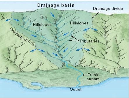
Basin properties refer to the physical, geological, and hydrological characteristics of a watershed or river basin that influence the quantity and quality of water available within it. Some important basin properties include:
- Size and shape: The size and shape of a basin determines the area from which water is collected and the quantity of water that can be stored within it.
- Topography: The topography of a basin determines the direction of flow of water and affects the rate of surface runoff.
- Geology: The geology of a basin determines the type of rocks and soils that are present, which can affect the storage and movement of groundwater.
- Soil characteristics: Soil characteristics such as texture, structure, and permeability affect the rate of infiltration of water into the ground and the amount of water that can be stored in the soil.
- Vegetation cover: Vegetation cover affects the rate of infiltration and evapotranspiration, which are important processes in the hydrologic cycle.
- Climate: Climate plays a major role in the hydrologic cycle, with temperature, precipitation, and evapotranspiration rates affecting the amount and distribution of water within a basin.
- Land use: Land use changes, such as urbanization or deforestation, can have a significant impact on the hydrologic cycle by altering surface runoff, infiltration rates, and evapotranspiration.

References
- Prof.Dr. FİKRET KAÇAROĞLU, Lecture Note, Muğla Sıtkı Koçman University
- Domenico, P.A., Schwartz, F.W., 1990. Physical and Chemical Hydrogeology. John Wileyand Sons, USA, 824 p.
- Fetter, C.W., 2001. Applied Hydrogeology (Fourth Ed.). Prentice Hall, USA, 598 p.
- Hiscock, K., 2005, Hydrogeology. Blackwell Publishing, 389p.
- Younger, P.L., 2007, Groundwater in the Environment. Blackwell Publishing, 318 p.
- Usul, N., Engineering Hydrology. METU Press, Ankara, 404 p.
- Newson, M., 1994. Hydrology and The River Environment. Oxford Univ. Pres, UK, 221 p.


