


")


Seismic waves are vibrations or oscillations that travel through the Earth, often as a result of sudden energy release due to geological processes. These waves play a crucial role in understanding the Earth’s interior and are integral to the field of seismology, a branch of geophysics that studies earthquakes and the structure of the Earth’s interior.
Definition of Seismic Waves: Seismic waves are categorized into two main types: body waves and surface waves. Body waves travel through the Earth’s interior, while surface waves propagate along its outer layer. The primary types of seismic waves are:
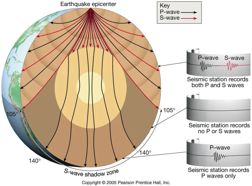
- P-waves (Primary or Compressional Waves): These are the fastest seismic waves and can travel through solids, liquids, and gases. P-waves cause particles to move in the same direction as the wave, leading to compressions and expansions.
- S-waves (Secondary or Shear Waves): S-waves are slower than P-waves and can only travel through solids. They cause particles to move perpendicular to the wave direction, resulting in a shearing or side-to-side motion.
- Surface Waves: These waves travel along the Earth’s surface and are typically more destructive during earthquakes. Love waves and Rayleigh waves are the two main types of surface waves, causing horizontal and elliptical particle motion, respectively.
Importance in Earth Science: Seismic waves are fundamental to understanding the Earth’s interior and are crucial for various reasons:
- Earthquake Studies: Seismic waves are the primary tool for studying earthquakes. They help seismologists locate the epicenter and determine the depth of an earthquake’s focus.
- Earth’s Interior Structure: By analyzing how seismic waves travel through the Earth, scientists can infer details about its composition, density, and structure. This information is vital for understanding the Earth’s layers, such as the crust, mantle, and core.
- Resource Exploration: Seismic surveys are used in the exploration of natural resources like oil and gas. By studying the reflection and refraction of seismic waves, geophysicists can identify subsurface structures and potential resource deposits.
- Tectonic Plate Dynamics: Seismic waves provide insights into the movement and interactions of tectonic plates. They help researchers understand plate boundaries, subduction zones, and the forces driving plate tectonics.
Historical Significance: The historical significance of seismic waves lies in their role in developing our understanding of the Earth’s internal structure and seismic activity. Notable historical milestones include:
- 1906 San Francisco Earthquake: The devastating earthquake in San Francisco prompted increased interest in understanding seismic waves and earthquakes. This event contributed to the development of early seismographs.
- 1960 Chilean Earthquake: The Great Chilean Earthquake, the most powerful earthquake ever recorded, provided valuable data for understanding seismic wave behavior and Earth’s interior.
- Plate Tectonics Theory: The study of seismic waves played a crucial role in the development of the plate tectonics theory, which revolutionized our understanding of the Earth’s dynamic processes.
In summary, seismic waves are essential for unraveling the mysteries of the Earth’s interior, studying earthquakes, and contributing to advancements in various scientific fields. Their historical significance lies in their role in shaping our understanding of the Earth’s structure and dynamic processes.
Types of Seismic Waves

Body Waves:

- Primary Waves (P-Waves):
- Characteristics:
- P-waves are compressional waves.
- They are the fastest seismic waves.
- Travel through solids, liquids, and gases.
- Cause compressions and expansions of material in the direction of wave propagation.
- Speed and Motion:
- Travel at speeds of approximately 5-8 km/s in the Earth’s crust.
- Particle motion is parallel to the direction of the wave.
- Characteristics:
- Secondary Waves (S-Waves):
- Characteristics:
- S-waves are shear or transverse waves.
- Slower than P-waves.
- Can only travel through solids.
- Cause side-to-side motion (shearing) of material perpendicular to the direction of wave propagation.
- Speed and Motion:
- Travel at speeds of approximately 2-5 km/s in the Earth’s crust.
- Particle motion is perpendicular to the direction of the wave.
- Characteristics:
Surface Waves:

- Love Waves:
- Characteristics:
- Love waves are a type of surface wave.
- They are guided by the Earth’s surface and do not penetrate the interior.
- Purely horizontal motion.
- Primarily responsible for causing horizontal shaking.
- Motion:
- Side-to-side (horizontal) motion perpendicular to the direction of wave propagation.
- Characteristics:
- Rayleigh Waves:
- Characteristics:
- Rayleigh waves are another type of surface wave.
- They travel along the Earth’s surface and involve both vertical and horizontal motion.
- They have a rolling elliptical motion.
- Cause both vertical and horizontal ground motion.
- Motion:
- Vertical and horizontal elliptical motion, with a net retrograde particle motion.
- Characteristics:
Understanding these characteristics helps seismologists analyze seismic data to determine the nature of the seismic source, study the Earth’s interior, and assess the potential impact of seismic events on the Earth’s surface.
Generation of Seismic Waves

Earthquakes as a Source:
- Faulting Mechanisms:
- Elastic Rebound Theory:
- Characteristics:
- According to the elastic rebound theory, rocks on either side of a fault are deformed by tectonic forces, storing elastic energy.
- When the stress exceeds the strength of the rocks, they suddenly rebound to their original undeformed state, releasing the stored energy.
- This sudden release generates seismic waves that propagate outward from the fault.
- Characteristics:
Human-Induced Seismicity:

- Activities Leading to Induced Seismicity:
- Mining and Quarrying:
- Extraction of minerals or large-scale removal of rock alters stress within the Earth’s crust, potentially inducing seismic events.
- Fluid Injection/Extraction:
- Activities such as hydraulic fracturing (fracking) for oil and gas extraction involve injecting fluids into the Earth’s crust, altering subsurface pressures and inducing seismicity.
- Geothermal Energy Extraction:
- The injection or extraction of fluids for geothermal energy production can induce seismic events by changing subsurface conditions.
- Reservoir-Induced Seismicity:
- The filling of large reservoirs behind dams changes the stress on the Earth’s crust, potentially triggering earthquakes.
- Mining and Quarrying:
- Examples:
- Fracking (Hydraulic Fracturing):
- The injection of high-pressure fluids into underground rock formations to extract oil and gas can induce seismic events.
- The fluid injection increases pore pressure, facilitating fault slippage.
- Reservoir-Induced Seismicity:
- Large reservoirs behind dams, such as those used for hydroelectric power generation, can induce seismicity.
- The weight of the water in the reservoir changes stress along faults and may lead to earthquakes.
- Geothermal Energy Extraction:
- The extraction of geothermal fluids for energy production can alter subsurface conditions and induce seismic activity.
- Changes in pressure and fluid flow can affect fault stability.
- Fracking (Hydraulic Fracturing):
Understanding the sources of seismic waves, whether natural (earthquakes) or human-induced, is crucial for assessing seismic hazards, studying Earth’s subsurface, and implementing measures to mitigate the potential impact of seismic events.
Detection and Measurement
Seismometers:

- Instrumentation:
- Sensor Design:
- Seismometers are devices designed to detect and record ground motion caused by seismic waves.
- The primary component is a seismometer sensor, which is typically a mass (pendulum or spring-mounted mass) that remains stationary while the ground moves.
- Transducer:
- The motion of the ground causes the sensor to move relative to a fixed frame.
- This relative motion is converted into an electrical signal by a transducer (usually a coil and magnet system or optical sensor).
- Instrument Response:
- Seismometers are calibrated to record specific frequencies of ground motion, and their response is characterized by the instrument response curve.
- Sensor Design:
- Operation:
- Installation:
- Seismometers are installed in stable locations, often in boreholes or on the Earth’s surface, to minimize interference from environmental noise.
- Data Transmission:
- Modern seismometers may transmit data in real-time via satellite or internet connections for rapid earthquake monitoring.
- Data Processing:
- Seismometer data undergoes processing to remove noise and enhance the seismic signal, improving the accuracy of earthquake detection.
- Installation:
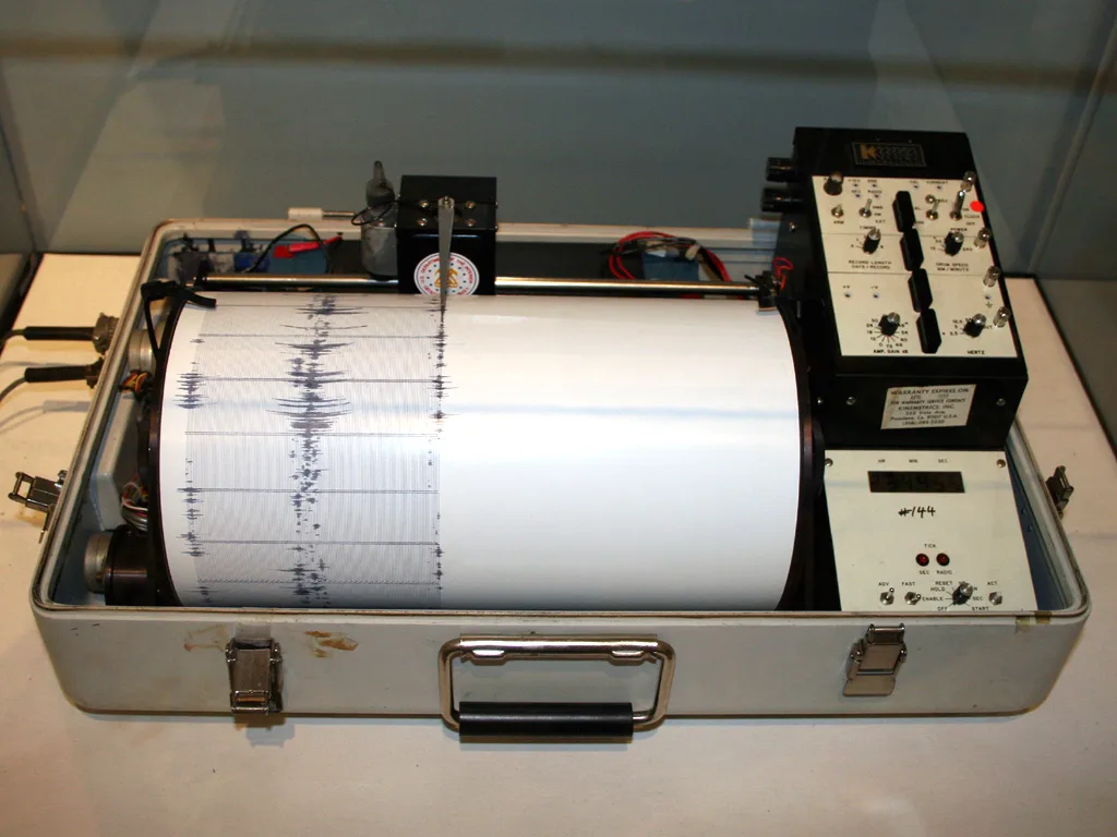
Seismographs:
- Recording and Interpretation:
- Recording Instrument:
- A seismograph is the instrument used to record seismic waves.
- It consists of a seismometer connected to a recording device.
- Paper or Digital Recordings:
- Traditionally, seismographs recorded data on paper in the form of seismograms.
- Modern seismographs often use digital data storage for more efficient and accurate recording.
- Amplitude and Frequency:
- Seismograms show the amplitude and frequency of seismic waves.
- Amplitude represents the wave’s size, while frequency indicates the number of oscillations per unit time.
- Recording Instrument:
- Seismogram Analysis:
- P-wave and S-wave Arrival Times:
- Seismologists analyze seismograms to determine the arrival times of P-waves and S-waves.
- The time delay between P-wave and S-wave arrivals provides information about the earthquake’s distance from the seismometer.
- Magnitude Determination:
- Seismograms are used to estimate earthquake magnitude, a measure of the energy released.
- The amplitude of seismic waves on the seismogram correlates with the earthquake’s magnitude.
- Depth and Location:
- Seismograms from multiple stations are used to triangulate the earthquake’s epicenter and determine its depth.
- Moment Tensor Solutions:
- Advanced seismogram analysis allows for the determination of the earthquake’s focal mechanism and the orientation of faulting.
- P-wave and S-wave Arrival Times:
Seismometers and seismographs play a crucial role in monitoring and understanding seismic events, providing valuable data for earthquake research, hazard assessment, and early warning systems.
Applications of Seismic Waves
Earthquake Monitoring and Early Warning Systems:
- Earthquake Monitoring:
- Seismic waves are crucial for monitoring and studying earthquakes. Seismometers detect and record the arrival times and amplitudes of seismic waves, helping scientists understand the characteristics of seismic events.
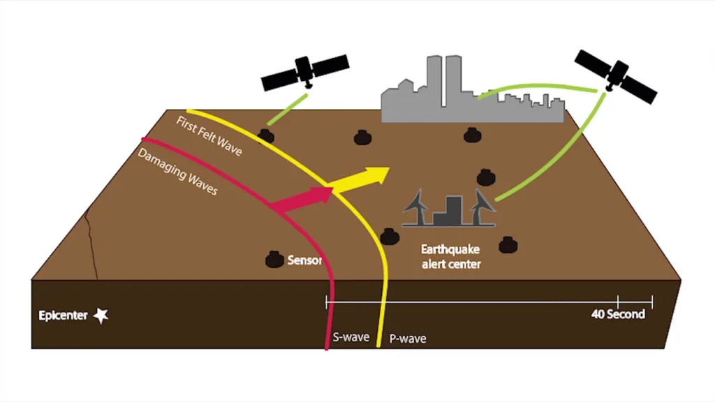
- Early Warning Systems:
- Seismic waves, particularly faster P-waves, can be used to provide early warnings for earthquakes. By detecting P-waves and estimating their arrival times, early warning systems can issue alerts seconds to minutes before the more damaging S-waves and surface waves arrive, allowing people to take protective measures.
Oil and Gas Exploration:
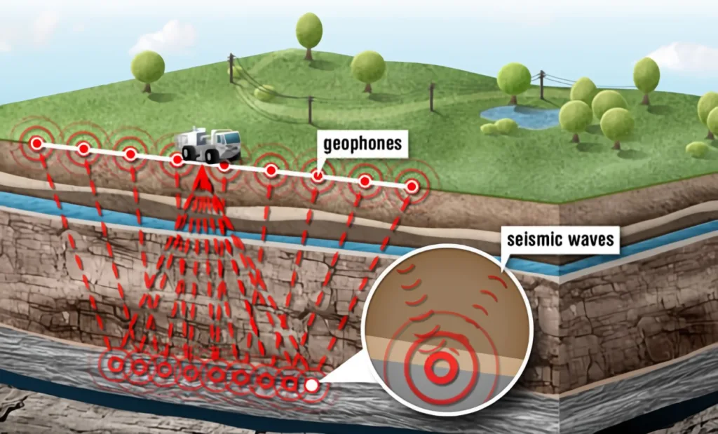
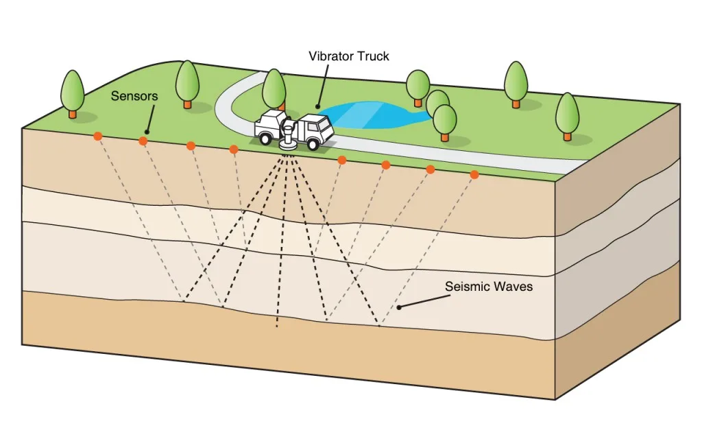
- Reflection Seismology:
- Seismic waves are extensively used in reflection seismology for oil and gas exploration.
- Seismic surveys involve the generation of controlled seismic waves, typically using sources like explosives or vibrators. The reflected waves are then recorded by sensors (geophones or hydrophones) to create subsurface images.
- Seismic Surveys:
- Reflection seismic surveys help map subsurface structures, including potential oil and gas reservoirs.
- By analyzing the time it takes for seismic waves to travel and the characteristics of the reflected waves, geophysicists can identify rock layers, faults, and other geological features.
Structural Imaging (e.g., subsurface imaging for civil engineering projects):
- Civil Engineering Projects:
- Seismic waves are employed in civil engineering for subsurface imaging before construction projects.
- Seismic surveys can assess the composition and stability of the ground, identify potential geological hazards, and help plan infrastructure projects.
- Tunneling and Dam Construction:
- Seismic methods assist in tunneling and dam construction by providing information about the subsurface conditions.
- Engineers use seismic data to plan routes, assess soil and rock properties, and ensure the stability of structures.
- Site Characterization:
- Seismic waves aid in site characterization for various construction projects.
- By understanding the subsurface layers, engineers can make informed decisions about foundation design, earthquake resistance, and overall structural integrity.
The applications of seismic waves extend beyond these examples, and they continue to play a crucial role in various scientific, industrial, and engineering fields. The ability to use seismic waves for imaging and analysis has revolutionized our understanding of the Earth’s interior and has practical implications for resource exploration, hazard assessment, and infrastructure development.


