")


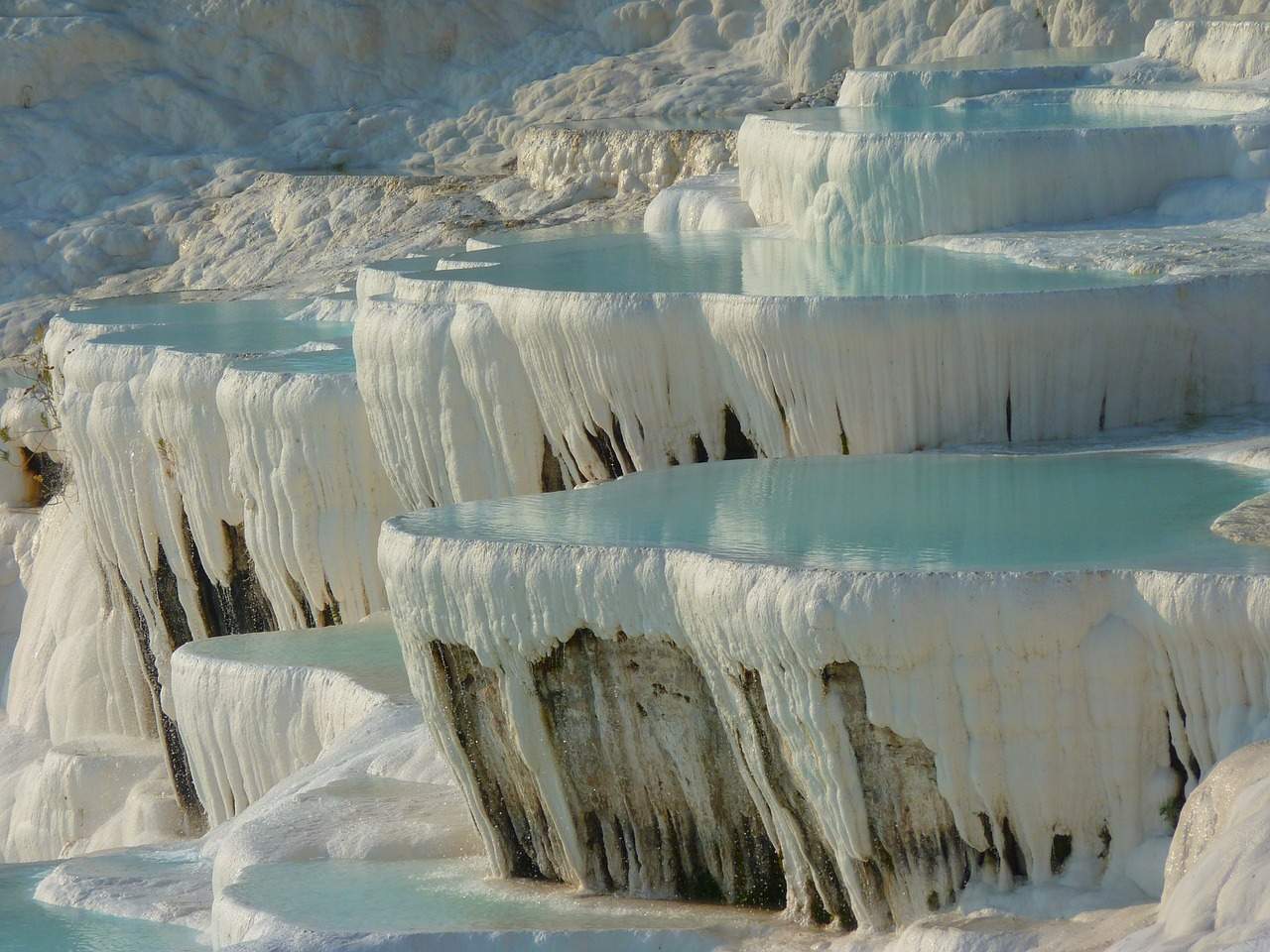
Pamukkale Travertines, Turkey

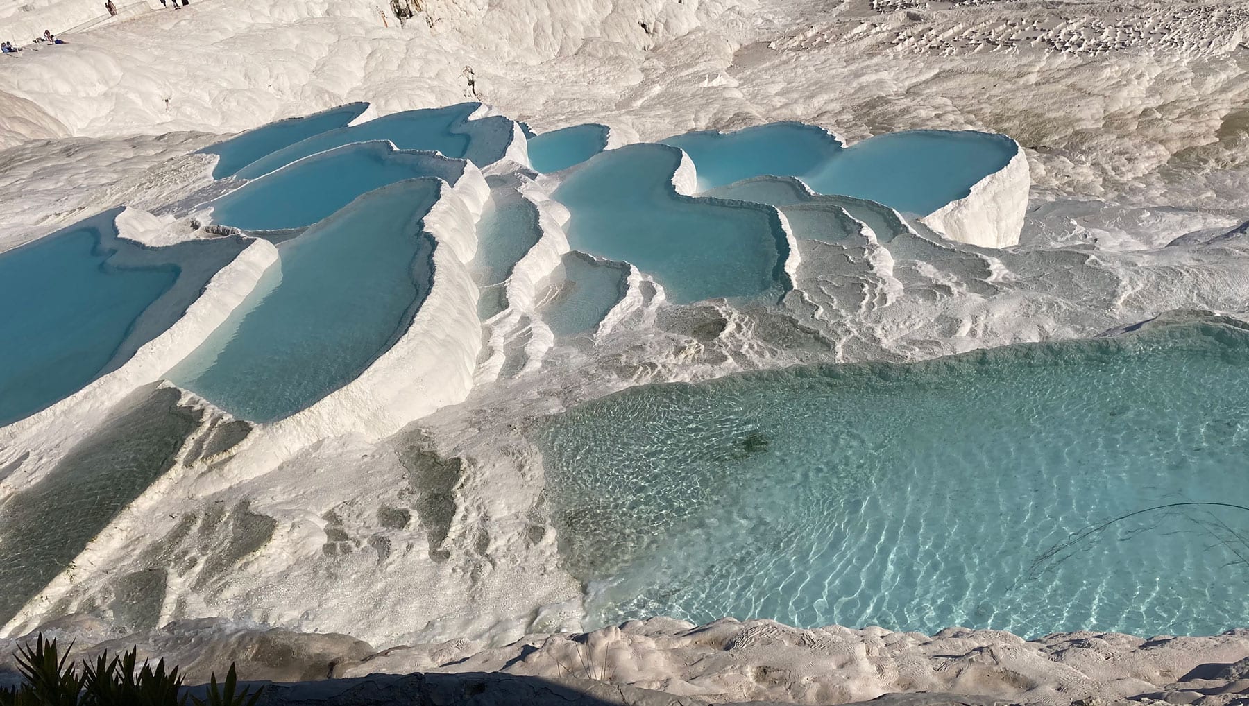
Pamukkale is a natural wonder located in the Denizli province of Turkey. The name “Pamukkale” means “cotton castle” in Turkish, and it is known for its breathtakingly beautiful white terraces of travertine, which are created by the flow of hot springs. The terraces are formed over thousands of years, as the water deposits calcium carbonate, which solidifies and creates the formations.
In addition to the terraces, there are also ruins of the ancient city of Hierapolis, which was founded in the 2nd century BC. The city was a major center of the Roman Empire and has many well-preserved structures, including a theater, a necropolis, and a temple. The ancient city and the terraces are both listed as UNESCO World Heritage Sites.
Visitors to Pamukkale can bathe in the hot springs and walk on the terraces, but the area is carefully managed to prevent damage to the fragile formations. There are also many other activities to enjoy in the surrounding area, such as hiking and exploring nearby villages.
Overall, Pamukkale is a must-visit destination for anyone traveling to Turkey, offering a unique and unforgettable natural and historical experience.

The Formation of Pamukkale Travertine
Pamukkale, which means “cotton castle” in Turkish, is a natural wonder located in the Denizli province of Turkey. The formation of Pamukkale is a result of a combination of geological and hydrological processes that have taken place over thousands of years.
The primary feature of Pamukkale is the travertine terraces, which are formed from the precipitation of calcium carbonate from the flowing water of the hot springs. The hot springs are fed by a system of underground aquifers that collect rainwater and snowmelt from the surrounding mountains. As the water travels through the earth, it picks up dissolved minerals, including calcium and bicarbonate.
When the hot water reaches the surface, it cools and loses some of its dissolved carbon dioxide, causing the calcium carbonate to precipitate and form solid deposits. Over time, these deposits build up and form the terraces, which are continually growing and changing.
The white color of the terraces is due to the high concentration of calcium carbonate in the water, which reflects sunlight and gives the appearance of snow. The travertine formations are unique in appearance due to the varying mineral content of the water, the flow rate, and the topography of the land.
In addition to the travertine terraces, the formation of Pamukkale has also been shaped by tectonic activity. The region is located in a seismically active area, and over time, the tectonic movements have caused the land to shift and create the undulating landscape seen today.
Overall, the formation of Pamukkale is a result of the interplay between hydrological, geological, and tectonic processes. It is a unique and fascinating natural wonder that offers visitors a glimpse into the power and beauty of the natural world.
Explanation of travertine terraces
Travertine terraces are a type of sedimentary rock formation that occurs when calcium carbonate-rich water flows over the surface of the earth and leaves behind deposits of minerals. The resulting terraces are typically made up of a series of steps or ledges that resemble giant staircases or frozen waterfalls.

Travertine is formed from the precipitation of calcium carbonate, which occurs when water that is saturated with calcium carbonate flows over a surface and evaporates. As the water evaporates, the calcium carbonate is left behind, creating layers of sediment that eventually harden into rock.
In the case of Pamukkale, the hot springs that flow through the underground karst system dissolve large amounts of calcium carbonate from the surrounding limestone. The water then travels to the surface and flows over the terraces, where it loses carbon dioxide and deposits the calcium carbonate as travertine.
The resulting terraces can vary in color, from bright white to brown or even orange, depending on the mineral content of the water and the amount of sunlight that the formations are exposed to. The travertine formations can also be quite delicate, and care must be taken to avoid damaging them.
Overall, travertine terraces are a fascinating geological formation that are found in many parts of the world. They are created by the slow and steady work of water and minerals, and offer a glimpse into the complex and ever-changing nature of the earth’s surface.
The role of hydrothermal activity in the formation of travertine
Hydrothermal activity plays a crucial role in the formation of travertine, including the travertine terraces found in Pamukkale, Turkey. Hydrothermal activity refers to the movement of hot water and steam beneath the earth’s surface, which can occur in areas where magma is present or where groundwater is heated by geothermal heat sources.
In the case of travertine formation, hydrothermal activity is responsible for creating the hot springs that supply the water and dissolved minerals needed for travertine deposition. In areas where hydrothermal activity is high, such as around volcanic regions or along tectonic plate boundaries, the resulting hot springs can be rich in minerals such as calcium carbonate, silica, and sulfur.
When the hot water from these springs reaches the surface, it cools and loses some of its dissolved gases, causing minerals to precipitate out of the water and form deposits of travertine. Over time, these deposits can build up and form the distinctive terraced formations seen in places like Pamukkale.
The chemistry of the hydrothermal water is also an important factor in the formation of travertine. The water must be saturated with dissolved minerals, such as calcium carbonate, in order for it to deposit the minerals and create travertine. The pH of the water is also important, as it can affect the solubility of minerals and the rate of travertine deposition.
In summary, hydrothermal activity plays a critical role in the formation of travertine, including the travertine terraces found in Pamukkale. The hot springs that are created by hydrothermal activity supply the water and dissolved minerals needed for travertine deposition, and the chemistry of the water affects the rate and nature of travertine formation.
Factors that contribute to the unique appearance of the terraces
The travertine terraces of Pamukkale, Turkey are known for their unique and stunning appearance, which is the result of several factors. Here are some of the factors that contribute to the distinctive look of the terraces:
- Mineral content: The mineral content of the water that flows over the terraces plays a significant role in their appearance. The water in Pamukkale’s hot springs is rich in calcium carbonate, which is what gives the terraces their white color. Other minerals such as magnesium, sodium, and potassium can also contribute to the colors seen in the terraces.
- Water flow rate: The rate at which water flows over the terraces can also affect their appearance. Slow-moving water can create more uniform, smooth terraces, while faster-moving water can create more irregular and jagged formations.
- Topography: The shape and slope of the land where the terraces form can also influence their appearance. The terraces in Pamukkale are located on a steep hillside, which creates a layered effect as the water cascades down the steps.
- Sunlight: The angle and intensity of sunlight hitting the terraces can also affect their appearance. The white travertine reflects sunlight, creating a dazzling effect, while the color of the water and minerals can change depending on the time of day and angle of the sun.
- Microorganisms: The presence of microorganisms in the water can also affect the appearance of the terraces. Some microorganisms can alter the mineral content of the water or create unique patterns and textures on the travertine.
Overall, the unique appearance of the terraces in Pamukkale is the result of a combination of geological, hydrological, and environmental factors. These factors work together to create a one-of-a-kind natural wonder that draws visitors from around the world.
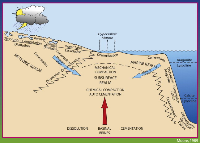
The Hydrogeology of Pamukkale Travertine
The hydrogeology of Pamukkale, Turkey is a complex system that includes both surface and subsurface water flows. The area is located within the Denizli Basin, which is a large sedimentary basin filled with limestone and other rock formations. The Denizli Basin is situated in a tectonic active zone, which has resulted in the formation of hot springs and other geothermal features.

The hot springs of Pamukkale are the result of geothermal activity in the area. The water in the hot springs is heated by geothermal heat sources deep beneath the earth’s surface. The heated water then rises to the surface through fissures and faults in the rock formations, creating hot springs and other geothermal features.
The hot springs of Pamukkale contain high levels of dissolved minerals, including calcium carbonate, which is the primary mineral responsible for the formation of the travertine terraces. The hot water dissolves calcium carbonate from the surrounding limestone as it flows through underground aquifers and channels. As the hot water reaches the surface, it cools and loses carbon dioxide, causing the calcium carbonate to precipitate out of the water and form travertine deposits.
The hydrogeology of Pamukkale also includes a complex system of channels and aquifers that transport water from the hot springs to the surface. These channels and aquifers are part of a larger karst system that is characterized by the dissolution of soluble rocks such as limestone and dolomite. The karst system of Pamukkale is responsible for the formation of numerous caves and sinkholes in the area.

Overall, the hydrogeology of Pamukkale is a complex and dynamic system that is shaped by geothermal activity, rock formations, and underground water flows. The hot springs and travertine terraces are just a small part of this system, which includes a rich and diverse array of geological features and processes.
The mineral composition of the travertine terraces
The mineral composition of the travertine terraces in Pamukkale, Turkey is primarily made up of calcium carbonate (CaCO3), which is the same mineral found in limestone and marble. Calcium carbonate is a naturally occurring compound that forms when calcium ions (Ca2+) and carbonate ions (CO32-) combine in water. The calcium ions are typically derived from the dissolution of limestone or other calcium-rich rocks, while the carbonate ions come from carbon dioxide (CO2) that is dissolved in the water.
In addition to calcium carbonate, the travertine terraces at Pamukkale may also contain other minerals that are present in the hot springs water. These minerals include magnesium (Mg), sodium (Na), potassium (K), and bicarbonate (HCO3-), among others. The precise mineral content of the travertine can vary depending on factors such as the temperature of the water, the flow rate, and the length of time the water spends in contact with the rock formations.
The high concentration of calcium carbonate in the hot springs water is due to the geothermal activity in the area. As the hot water rises to the surface, it dissolves calcium carbonate from the surrounding limestone and other rock formations. When the water reaches the surface and cools, the dissolved calcium carbonate begins to precipitate out of the water and form travertine deposits. Over time, these deposits can accumulate to form the terraced structures that are so characteristic of Pamukkale.
In addition to its aesthetic appeal, the travertine terraces of Pamukkale are also of scientific interest due to their unique mineral composition. The terraces provide a natural laboratory for studying the precipitation of calcium carbonate and other minerals, as well as the role of hydrothermal activity in shaping the landscape. The mineral composition of the travertine can also provide insights into the geology and history of the region, including the types of rock formations that underlie the area and the processes that have shaped them over time.
The geological time scale of Pamukkale’s formation
The geological time scale of Pamukkale’s formation extends over millions of years and encompasses a variety of geological processes. The rock formations that underlie the area are primarily composed of limestone and other sedimentary rocks that were deposited during the Mesozoic Era, which lasted from approximately 252 to 66 million years ago. During this time, the Denizli Basin was a shallow marine environment, and layers of limestone and other sedimentary rocks were deposited on the sea floor.
After the Mesozoic Era, the area underwent a period of tectonic activity, which resulted in the formation of faults and fractures in the rock formations. This tectonic activity also led to the uplift of the Denizli Basin and the formation of the surrounding mountain ranges. As a result of this uplift, the limestone and other sedimentary rocks were exposed to the elements and began to erode.
The hot springs and travertine terraces of Pamukkale were formed much more recently, during the Quaternary Period, which began approximately 2.6 million years ago and continues to the present day. During this time, the area experienced a period of intense volcanic activity, which led to the formation of the nearby Mount Honaz and other volcanic features. The volcanic activity also created a source of geothermal heat that continues to drive the hot springs and other geothermal features in the area.
The travertine terraces themselves are thought to have formed over the past few thousand years, as a result of the precipitation of calcium carbonate from the hot springs water. The exact timeline of their formation is difficult to determine, as the terraces continue to evolve and change in response to ongoing hydrothermal activity and other environmental factors.
Overall, the geological time scale of Pamukkale’s formation encompasses a wide range of geological processes and spans millions of years. The hot springs and travertine terraces are just one small part of this larger geological history, which has shaped the landscape and created the unique features that make Pamukkale such a fascinating and important geological site.
The Tectonic History of Pamukkale
Pamukkale and its surrounding region are located in a tectonically active area where the African and Eurasian plates converge. The tectonic history of the area has played an important role in shaping the landscape and contributing to the formation of the hot springs and travertine terraces that are found there today.
The region is situated within the Aegean extensional province, which is characterized by a complex network of active faults and earthquakes. The convergence of the African and Eurasian plates has resulted in the formation of a compressional regime, which is responsible for the formation of the Anatolian mountain range to the east of Pamukkale. This compression has also led to the formation of faults and fractures in the rock formations beneath the area, which have played a key role in the hydrogeology of the region.
The tectonic history of the region also includes periods of extension, which have led to the formation of grabens, or down-dropped blocks of the Earth’s crust. The Denizli Graben is one such feature, and it is thought to have formed during the Miocene epoch, which lasted from approximately 23 to 5.3 million years ago. The graben is bounded by active faults, which continue to move and contribute to the ongoing tectonic activity in the area.
The tectonic activity in the region has also played a role in the formation of the nearby volcanic features, such as Mount Honaz. The volcanism in the area is thought to be related to the subduction of the African plate beneath the Aegean Sea, which has led to the formation of a magmatic arc along the western margin of Anatolia.
Overall, the tectonic history of Pamukkale and its surrounding region is complex and dynamic, with ongoing activity that continues to shape the landscape. The convergence of the African and Eurasian plates has led to the formation of mountain ranges, faults, and grabens, while the extensional forces have contributed to the formation of volcanic features and other geological structures. This tectonic activity has also played a key role in the hydrogeology of the region, contributing to the formation of the hot springs and travertine terraces that are found in Pamukkale today.
Summary of the geology of Pamukkale
Pamukkale is a unique geological site located in the Denizli Province of southwestern Turkey. The area is known for its travertine terraces, which are formed by the precipitation of calcium carbonate from the hot springs that are found in the area. The geology of Pamukkale is complex and encompasses a variety of geological processes and features.
The rock formations that underlie Pamukkale are primarily composed of limestone and other sedimentary rocks that were deposited during the Mesozoic Era, which lasted from approximately 252 to 66 million years ago. During the Quaternary Period, which began approximately 2.6 million years ago and continues to the present day, the area experienced a period of intense volcanic activity, which led to the formation of nearby Mount Honaz and other volcanic features.
The hot springs and travertine terraces of Pamukkale were formed much more recently, over the past few thousand years. The travertine terraces are thought to have formed as a result of the precipitation of calcium carbonate from the hot springs water, which is heated by geothermal heat associated with the nearby volcanic activity. Ongoing hydrothermal activity and other environmental factors continue to shape the terraces and contribute to their unique appearance.
The tectonic history of Pamukkale and its surrounding region is also important in shaping the landscape and contributing to the formation of the hot springs and travertine terraces. The area is situated within a tectonically active region where the African and Eurasian plates converge, and this activity has led to the formation of mountain ranges, faults, and grabens, as well as contributing to the formation of nearby volcanic features.
Overall, the geology of Pamukkale is fascinating and complex, encompassing a wide range of geological processes and features. The travertine terraces and hot springs are just one small part of this larger geological history, which has shaped the landscape and created the unique features that make Pamukkale such an important geological site.