


")


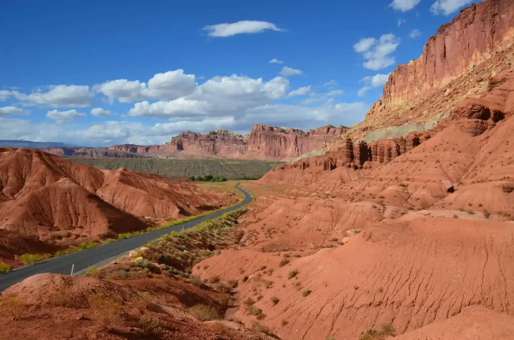
Capitol Reef National Park is situated in south-central Utah, United States. The park encompasses an area of approximately 241,904 acres, making it one of the smaller national parks in Utah. It is part of the larger region known as the Waterpocket Fold, a nearly 100-mile long warp in the Earth’s crust that exposes various layers of sedimentary rock.
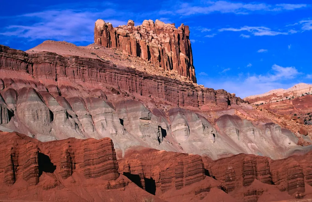
Unique Geological Features: Capitol Reef National Park is renowned for its striking geological formations, shaped over millions of years. The park’s uniqueness lies in its diverse and colorful rock layers, deep canyons, towering monoliths, and the Waterpocket Fold itself. Here are some key geological features that make Capitol Reef special:
- Waterpocket Fold: The Waterpocket Fold is the defining geological feature of Capitol Reef. It is a classic example of a monocline, where a rock layer is pushed up at an angle while the other side remains relatively flat. This fold is responsible for the steep cliffs and rugged terrain found throughout the park.
- Capitol Dome: The Capitol Dome, a prominent white sandstone formation, stands as a symbol of the park. It resembles the U.S. Capitol building, hence the name. This monolith is part of the Navajo Sandstone formation and is a popular subject for photographers.
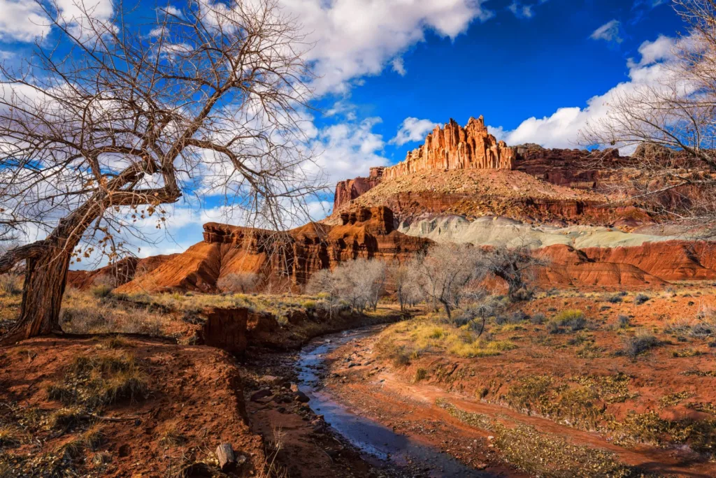
- Cathedral Valley: Cathedral Valley is a remote area within the park characterized by towering monoliths and sandstone formations. The Temple of the Sun and the Temple of the Moon are two iconic structures found in this region.
- Slot Canyons: Capitol Reef is home to numerous slot canyons, narrow passages carved by water over millions of years. These canyons, such as Capitol Gorge and Sulphur Creek, provide opportunities for hikers to explore the park’s geology up close.
- Fruita Historic District: Beyond the geological formations, Capitol Reef has a human history represented by the Fruita Historic District. Settlers established orchards in the fertile Fruita valley, and remnants of their stone-walled orchards can still be seen today, adding a cultural dimension to the park.
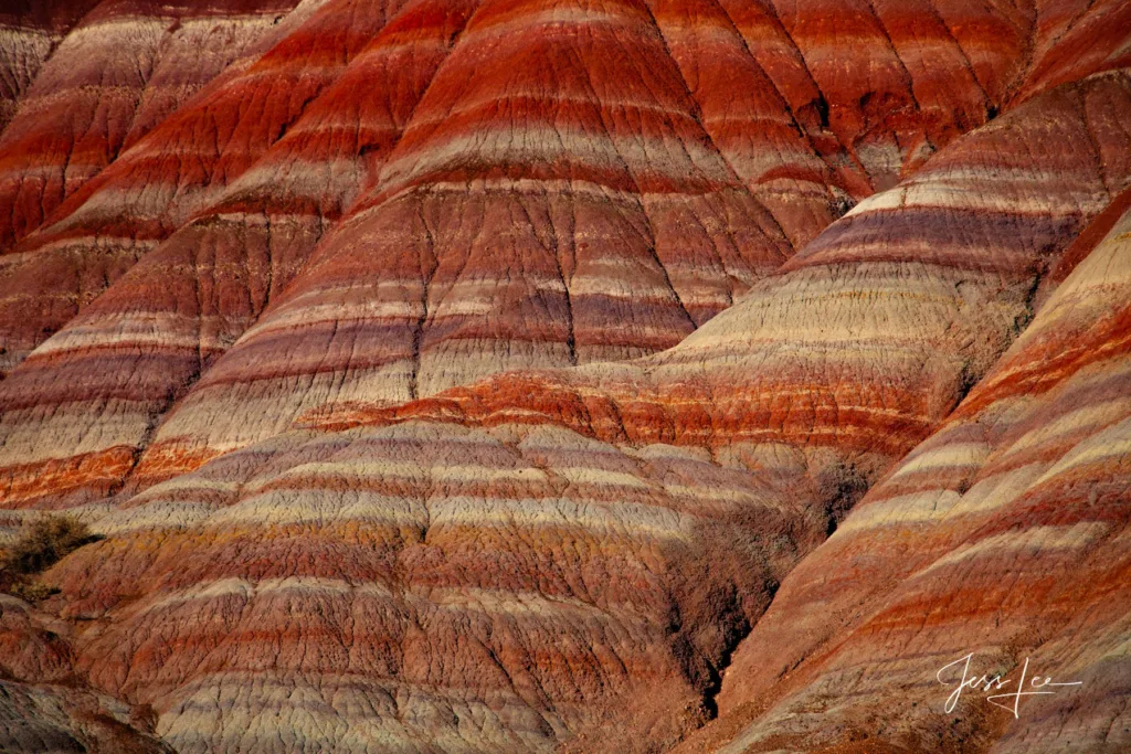
- Colorful Rock Layers: The park features a kaleidoscope of colors in its rock layers, ranging from deep reds to pale yellows and whites. These layers represent different geological periods, and the unique hues result from varying mineral content and environmental conditions during their formation.
Capitol Reef National Park’s geology offers a captivating journey through time, showcasing the forces of nature that shaped this rugged and visually stunning landscape. Whether exploring the canyons, admiring the monoliths, or appreciating the history of Fruita, visitors to Capitol Reef are treated to a remarkable display of Earth’s geological wonders.
Formation of the Waterpocket Fold
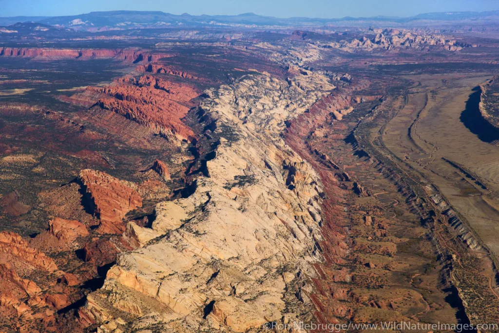
The Waterpocket Fold is a geologic feature that defines the landscape of Capitol Reef National Park, spanning nearly 100 miles in south-central Utah. This remarkable fold is a classic example of a monocline, a type of fold where one side of the rock strata is relatively flat, and the other side is steeply inclined. The formation of the Waterpocket Fold is a result of complex geological processes that unfolded over millions of years.
Geological Forces:
- Sedimentation: The story of the Waterpocket Fold begins with sedimentation during the Paleozoic Era, around 70 to 270 million years ago. At this time, the area that is now Capitol Reef was covered by a vast inland sea. Over millions of years, layers of sediment accumulated at the bottom of this sea, forming deposits of sand, silt, and other materials.
- Lithification: As more layers of sediment accumulated, the lower layers experienced compaction and cementation processes, transforming loose sediments into solid rock through a process known as lithification. Over time, these layers turned into different types of sedimentary rock, including sandstone, shale, and limestone.
- Uplift and Compression: Around 50 to 70 million years ago, tectonic forces caused the region to uplift. This uplift was not uniform; instead, it resulted in a regional flexure or warp in the Earth’s crust. The forces at play were likely a combination of compression and folding, with the Earth’s crust being pushed from different directions.
- Monocline Formation: The differential uplift and compression led to the formation of the Waterpocket Fold. The rocks on one side of the fold were lifted and tilted, creating a steeply inclined slope, while the rocks on the other side remained relatively horizontal. This asymmetric folding is what characterizes a monocline.
- Erosion: The uplift and tilting of the rock layers exposed them to the forces of erosion, primarily by water. Over millions of years, rivers and streams carved deep canyons, revealing the intricate layers of rock that make up the Waterpocket Fold. The erosive forces continue to shape the landscape today.
- Colorful Rock Layers: The different colors observed in the rock layers of the Waterpocket Fold are a result of varying mineral content and environmental conditions during the sedimentation process. Iron, manganese, and other minerals impart shades of red, yellow, white, and other hues to the rocks, creating a visually stunning and diverse geological tapestry.
The Waterpocket Fold, with its striking cliffs, canyons, and monoliths, stands as a testament to the dynamic geological forces that have shaped the Earth’s crust over geological time scales. Visitors to Capitol Reef National Park can witness the incredible results of these processes, gaining a deeper appreciation for the forces that have sculpted this unique and captivating landscape.
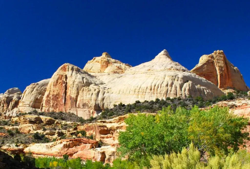
1. Navajo Sandstone:
The Navajo Sandstone is one of the prominent rock formations found in Capitol Reef National Park, contributing to the park’s unique and captivating landscape. Key features and geological significance include:
- Composition and Appearance: Navajo Sandstone is a thick layer of cross-bedded, fine to medium-grained sandstone that exhibits a striking reddish to light-orange color. The sandstone often appears as massive cliffs and domes, contributing to the iconic and colorful scenery of the park.
- Formation and Age: The Navajo Sandstone was deposited during the Jurassic Period, approximately 180 to 190 million years ago. It represents an ancient desert environment where vast sand dunes were preserved and solidified over time, forming the distinctive rock layer seen in Capitol Reef.
- Erosional Patterns: The Navajo Sandstone is highly resistant to erosion, creating towering cliffs and prominent features like the Capitol Dome within the park. The cross-bedding, a result of wind-blown sand dunes, adds to the unique patterns visible in the exposed rock faces.
- Cultural Significance: Beyond its geological importance, the Navajo Sandstone holds cultural significance, as it serves as a canvas for the petroglyphs and rock art left by ancient inhabitants of the region. These markings provide insights into the lives and beliefs of the people who once called this area home.
2. Entrada Sandstone:
Another significant rock formation in Capitol Reef National Park is the Entrada Sandstone, contributing to the diverse geological tapestry of the region. Key characteristics and geological significance include:
- Composition and Appearance: The Entrada Sandstone is a multicolored rock layer that can display hues of red, orange, and white. It is often interspersed with layers of shale and siltstone. The sandstone appears in various formations, including domes, arches, and buttes.
- Formation and Age: The Entrada Sandstone was deposited during the Jurassic Period, roughly 150 to 160 million years ago. The sediments that make up the Entrada Sandstone were deposited in an environment that alternated between shallow marine conditions and terrestrial settings.
- Erosional Patterns: While not as resistant as the Navajo Sandstone, the Entrada Sandstone still contributes to the park’s rugged terrain. The softer layers erode more easily, creating arches and alcoves, adding to the scenic beauty of Capitol Reef.
- Arches and Natural Bridges: Entrada Sandstone is known for contributing to the formation of natural arches and bridges within the park. These features, such as Hickman Bridge, are a result of erosional processes where softer rock layers underneath the sandstone are worn away, leaving behind the impressive formations.
Understanding the geological significance of the Navajo Sandstone and Entrada Sandstone provides insight into the ancient environments and processes that shaped Capitol Reef National Park. These rock layers not only contribute to the park’s stunning visual appeal but also serve as windows into the Earth’s distant past. Visitors can witness the interplay of colors, textures, and formations that tell the geological story of this remarkable landscape.
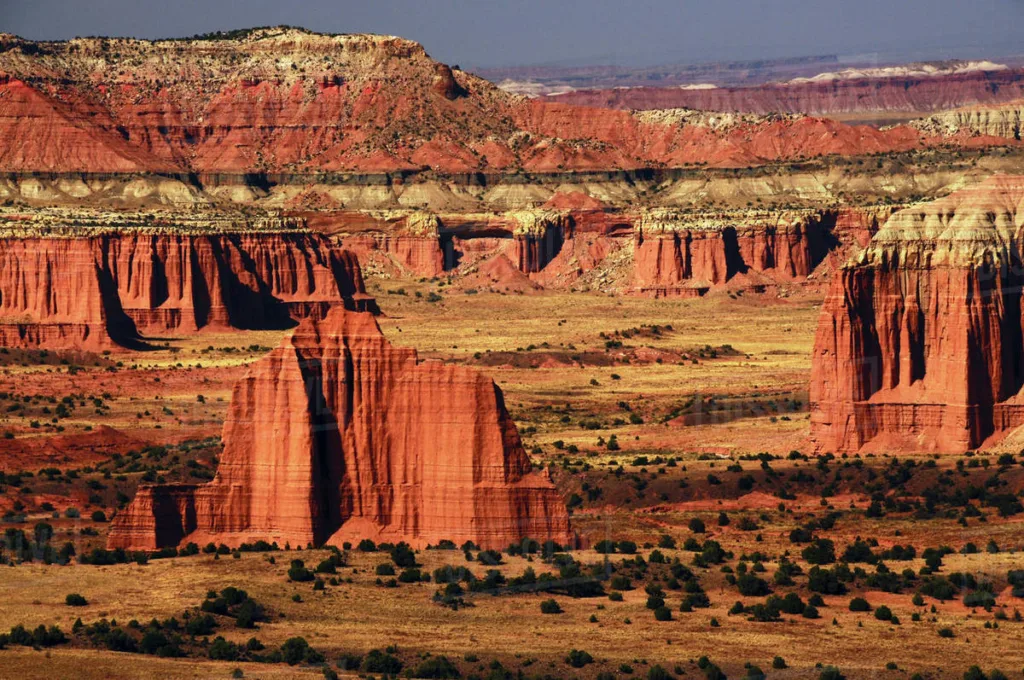
Cathedral Valley in Capitol Reef National Park
-Danita Delimont- Stock Photo – Dissolve
Geological Formations:
Cathedral Valley is a remote and visually stunning area within Capitol Reef National Park, known for its towering monoliths, temples, and unique geological formations. Some of the key features within Cathedral Valley include:
- Temple of the Sun and Temple of the Moon:
- Two massive monoliths that stand as iconic symbols of Cathedral Valley.
- The Temple of the Sun is a tall, narrow structure, while the Temple of the Moon is broader and shorter.
- These formations are composed of Entrada Sandstone and create a captivating silhouette against the desert sky.
- The Walls:
- Steep cliffs and rock walls surround Cathedral Valley, creating a sense of isolation and grandeur.
- The sheer size of the walls adds to the majestic and imposing atmosphere of the area.
- Glass Mountain:
- Cathedral Valley Loop Road:
- A scenic drive that allows visitors to explore the various formations and experience the vastness of Cathedral Valley.
- The loop road offers panoramic views of the monoliths and temples, making it a popular route for photographers and nature enthusiasts.
Erosion Processes:
The striking monoliths and temples of Cathedral Valley were sculpted over millions of years by the relentless forces of erosion. Several erosion processes have played a significant role in shaping these geological wonders:
- Water Erosion:
- Rainfall, although infrequent in the desert environment, has played a crucial role in shaping Cathedral Valley. Water, over time, has carved intricate patterns into the sandstone, creating channels and exposing the underlying rock layers.
- Wind Erosion:
- Wind-blown sand and particles have acted as natural abrasives, slowly wearing away the surface of the rock formations. This process, known as aeolian erosion, has contributed to the smooth, sculpted appearance of the monoliths and cliffs.
- Freeze-Thaw Action:
- Fluctuations in temperature, particularly during the freezing and thawing cycles, contribute to the breakdown of rock. Water seeps into cracks in the rock, freezes, and expands, exerting pressure that gradually fragments the rock over time.
- Chemical Weathering:
- Chemical processes, such as the dissolution of minerals by water, contribute to the weathering of the rock. This is particularly evident in the presence of gypsum in formations like Glass Mountain, where soluble minerals can be dissolved and transported away.
- Biological Weathering:
- The activities of plants and microorganisms also play a role in the weathering of rocks. Plant roots can penetrate cracks, exerting pressure and contributing to the breakdown of the rock.
The combination of these erosional forces, acting over geological time scales, has resulted in the unique and awe-inspiring formations found in Cathedral Valley. The interplay of water, wind, temperature variations, and biological activity has given rise to a landscape that showcases the dynamic processes shaping the Earth’s surface. Visitors to Cathedral Valley can witness the ongoing impact of these forces and appreciate the beauty that has emerged from the intricate dance of erosion and geological time.
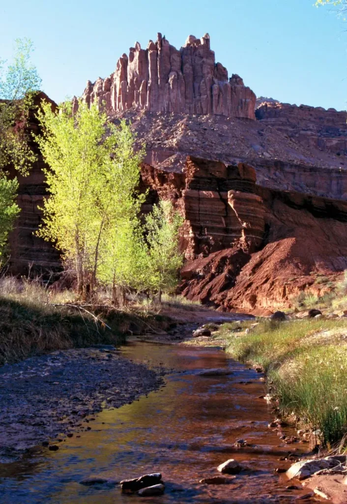
Fruita and the Fremont River in Capitol Reef National Park
Fruita Area Overview:
Fruita is a historic district within Capitol Reef National Park, situated along the fertile floodplain of the Fremont River. Unlike many other areas in the park known for their towering cliffs and rugged canyons, Fruita offers a different perspective with its lush greenery and orchards. The geological features in the Fruita area include:
- Fremont River:
- The Fremont River is a perennial stream that flows through Capitol Reef National Park, providing a crucial water source to the Fruita valley.
- Fruita’s location along the river has made it historically significant, attracting early settlers who recognized the agricultural potential of the fertile valley.
- Fruit Orchards:
- Fruita is famous for its historic fruit orchards, particularly apple and peach trees. The settlers planted these orchards, and today, visitors can still enjoy the fruit by participating in orchard tours or picking fruit during the harvest season.
- Historic Buildings:
- The Fruita district features several historic buildings, including a one-room schoolhouse, the Gifford Homestead, and the Fruita Rural Historic District, providing insight into the lives of the early settlers.
- Scenic Beauty:
- Fruita is surrounded by the towering red cliffs of Capitol Reef, creating a picturesque setting that combines the lush greenery of the valley with the dramatic desert landscape.
Influence of the Fremont River:
The Fremont River has played a significant role in shaping the landscape of Capitol Reef, particularly in the Fruita area. Its influence can be observed in several ways:
- Erosion and Sedimentation:
- The Fremont River has been a powerful agent of erosion, cutting through the layers of sedimentary rock over millions of years. As the river flows, it carries sediment downstream, contributing to the formation of canyons and valleys.
- Alluvial Deposits:
- The floodplain along the Fremont River is characterized by alluvial deposits, consisting of fertile soil carried by the river. This soil has been crucial for the success of agriculture in Fruita, providing nutrients for the growth of fruit trees and other crops.
- Canyon Formation:
- The Fremont River has carved deep canyons, such as the scenic Capitol Gorge, showcasing the erosive power of water over time. These canyons offer opportunities for hiking and exploration, allowing visitors to witness the intricate layers of rock exposed by the river.
- Wildlife Habitat:
- The riparian habitat along the Fremont River supports a diverse range of plant and animal life. Cottonwood trees, willows, and other vegetation thrive along the riverbanks, creating a haven for wildlife, including birds and small mammals.
- Cultural Significance:
- The availability of water from the Fremont River made Fruita an attractive location for settlement. The early Mormon pioneers recognized the importance of the river for irrigation and established orchards and farmland, leaving behind a rich cultural legacy that visitors can explore today.
The interplay between the Fremont River and the landscape of Capitol Reef, especially in the Fruita area, highlights the dynamic relationship between water, erosion, and the formation of both natural and cultural features. The river has not only shaped the geology of the region but has also contributed to the agricultural history and scenic beauty of Fruita within Capitol Reef National Park.
Capitol Dome and Capitol Gorge
Capitol Dome:
Geological Formation:
The Capitol Dome is a prominent and iconic rock formation within Capitol Reef National Park. Here are key aspects of its geological formation:
- Composition and Appearance:
- The Capitol Dome is primarily composed of Navajo Sandstone, a prominent rock layer within the park.
- It stands as a massive, rounded monolith with a distinct white to light-orange color, creating a striking contrast against the red cliffs and canyons that characterize the surrounding landscape.
- Navajo Sandstone:
- The Navajo Sandstone, which forms the Capitol Dome, was deposited during the Jurassic Period, approximately 180 to 190 million years ago.
- This sandstone was originally part of an extensive desert environment, with vast sand dunes that eventually solidified into the rock layers visible today.
- Erosion Resistance:
- The Capitol Dome is a testament to the differential erosion resistance of the Navajo Sandstone. Unlike surrounding rocks, the Navajo Sandstone is more resistant to weathering, allowing the dome to stand tall as a prominent feature in the park.
- Cross-Bedding Patterns:
- The Navajo Sandstone often displays cross-bedding, a geological feature formed by the migration of ancient sand dunes. This creates distinctive patterns in the rock layers, contributing to the visual appeal of the Capitol Dome.
- Cultural Significance:
- The Capitol Dome, resembling the U.S. Capitol building, has cultural significance and is often featured in photographs capturing the essence of Capitol Reef National Park.
Capitol Gorge:
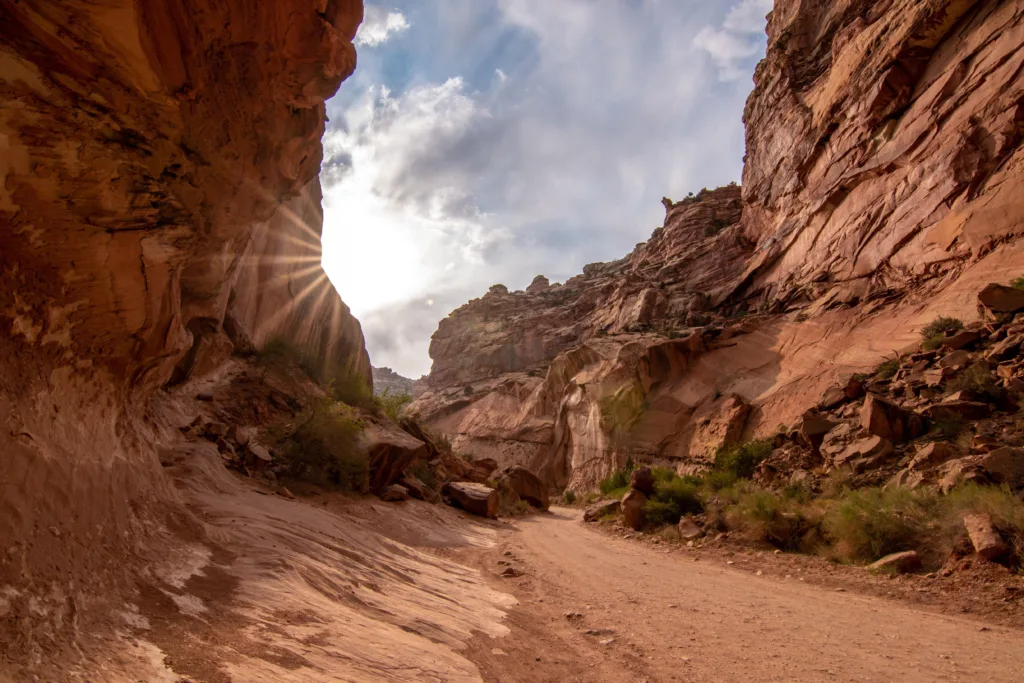
Capitol Gorge is a scenic canyon and one of the main attractions within Capitol Reef National Park. Here’s an exploration of its unique geological features:
- Canyon Formation:
- Capitol Gorge was carved by the erosive forces of water, primarily the Fremont River, which cut through the sedimentary rock layers over millions of years.
- The canyon is characterized by towering cliffs on either side, showcasing the intricate layers of rock that make up the Waterpocket Fold.
- Petroglyphs:
- The smooth rock walls of Capitol Gorge bear witness to ancient human presence. Petroglyphs, rock engravings created by indigenous peoples, can be found along the canyon walls, providing a glimpse into the cultural history of the region.
- Narrows Section:
- The canyon features a narrow section known as the Narrows, where the cliffs close in, creating a more confined and dramatic passage. Hiking through this section allows visitors to experience the geological and spatial uniqueness of Capitol Gorge.
- Pioneer Register:
- Along the canyon walls, visitors can find inscriptions left by early pioneers who traveled through Capitol Gorge. This “Pioneer Register” serves as a historical record of the park’s exploration and settlement.
- Waterpocket Fold Exposures:
- Capitol Gorge provides an excellent opportunity to see exposed layers of the Waterpocket Fold up close. The tilted rock layers showcase the geologic history of the region, revealing the effects of tectonic forces that created the fold.
The combination of the majestic Capitol Dome and the captivating Capitol Gorge offers visitors a diverse and enriching experience within Capitol Reef National Park. The geological formations and cultural history found in these areas contribute to the park’s unique charm and educational value.


