


")


Structural geology is the study of the internal structure and deformation of the Earth’s crust. Structural geologists use a variety of techniques, including field observations, mapping, geophysical methods, and laboratory experiments, to study the way in which rocks are deformed and the processes that control deformation.
Structural geology is an important field because it helps us understand the processes that shape the Earth’s surface, such as mountain building, faulting, and folding. It also has practical applications in fields such as civil engineering, where the characteristics of rocks and the forces that act on them are important for the design of structures such as bridges and buildings.
Some of the main topics studied in structural geology include:
- Stress and Strain: Definition of stress and strain, types of stress and strain, and their effects on rocks.
- Rock Deformation: Types of rock deformation, including brittle, ductile, and plastic deformation, and the factors that control deformation.
- Faults: Definition, classification, and geometry of faults, the mechanics of faulting, and the relationship between faults and earthquakes.
- Folds: Definition, classification, and geometry of folds, the mechanics of folding, and the relationship between folds and rock deformation.
- Joints and Fractures: Definition and classification of joints and fractures, their causes and effects, and their relationship with structural geology.
- Geological Maps: Principles of geological mapping, interpretation of geological maps, and the use of geological maps in structural geology.
- Structural Analysis: Techniques for analyzing the structure of rocks, including stereographic projection, cross-sections, and 3D modeling.
- Plate Tectonics: The relationship between plate tectonics and structural geology, the role of plate boundaries in rock deformation, and the effects of plate tectonics on the Earth’s crust.
- Applications of Structural Geology: The practical applications of structural geology, including mineral exploration, hydrocarbon exploration, and geotechnical engineering.
- Regional Structural Geology: The study of large-scale structural features, including mountain belts, basins, and rift systems, and their relationship with plate tectonics.
- Geological Structures and Geohazards: The relationship between geological structures and natural hazards, including landslides, rockfalls, and earthquakes.
What is a geologic structure ?
Geologic structure refers to the three-dimensional arrangement of rock units, mineral deposits, and other geological features in the Earth’s crust. Geologic structures are the result of various geological processes such as deformation, erosion, and deposition. These structures can range in scale from microscopic features like mineral grain orientation to large-scale features like mountain belts and sedimentary basins.
Some common types of geologic structures include faults, folds, joints, fractures, and unconformities. Faults are zones of rock fracture where one side of the fracture has moved relative to the other, while folds are bends or curves in rock layers caused by compressive forces. Joints and fractures are cracks in the rock that do not involve displacement, while unconformities are gaps in the geological record where rock layers are missing due to erosion or non-deposition.
Folds are geologic structures that result from the bending and deformation of rocks. They can range in size from small, subtle folds to large, dramatic folds, such as mountain ranges.
Faults are geologic structures that result from the movement of rocks along a fracture or break in the Earth’s crust. Faults can range in size from small, localized fractures to large, regional faults that extend for hundreds of kilometers.
Joints are geologic structures that result from the cracking of rocks along planes of weakness, without significant displacement of the rocks. Joints can be caused by a variety of processes, such as cooling, drying, and tectonic forces.
Geologic structures are an important field of study because they help us understand the processes that shape the Earth’s crust and the history of the Earth’s surface. They also have practical applications in fields such as civil engineering and resource exploration, where the characteristics of geologic structures are important for the design of structures and the evaluation of resource deposits.
It is the branch of geology that deals with:
- Form, arrangement and internal architecture of rocks
- Description, representation, and analysis of structures from the small to moderate scale
- Reconstruction of the motions of rocks
What is structural geology ?
Structural Geology is a sub-discipline of geology that deals with the study of the deformation and structure of rocks in the Earth’s crust. It involves the analysis of the spatial distribution and orientation of rock units, the geometry of rock layers and other geological features, and the mechanisms that cause deformation of rocks. Structural geologists use a variety of tools and techniques to analyze and interpret geological structures, such as field mapping, laboratory analysis of rock samples, and computer-based modeling.
The study of structural geology is important for a wide range of geological and engineering applications. For example, structural geologists may study the structural characteristics of rocks to identify and locate mineral deposits, oil and gas reservoirs, or groundwater aquifers. They may also analyze geological structures to assess the stability of slopes, tunnels, or buildings, or to understand the potential for earthquakes and other natural hazards.
The field of structural geology is closely related to other areas of geology, such as petrology, sedimentology, and tectonics. It is also closely connected to other fields of study, including geophysics, engineering geology, and environmental geology.
It is the branch of geology that studies the 3D geometry from micro to macro scale of rocks to explain the deformation processes the rocks experienced since their origination.
It introduces the physical side of Geological Sciences and emphasizes:
- Geometry (shape, orientation, position, size, etc.)
- Motion (beginning and ending positions and paths of particles and bodies—deformation or change in geometry)
- Mechanics (explanations of why the geometry and motion are asthey are)
Includes lots of observations from the field (but also some from the laboratory and the computermodelling)
Teaches you not only facts, but also skills and techniques that are necessary in advanced classes and central to geologic practice.
Structural geology provides information about the conditions during regional deformation using structures.
What are the job opportunities for a structural geologist ?
There are several job opportunities for a structural geologist, including:
- Mineral exploration and mining industry: Structural geologists can work for mining companies to identify and assess mineral deposits and their structures. They can also work in mineral exploration to identify new mineral deposits.
- Engineering and construction industry: Structural geologists can work in the engineering and construction industry to assess the stability of structures such as dams, bridges, and tunnels. They can also assist in the design and construction of such structures to ensure their stability.
- Oil and gas industry: Structural geologists can work in the oil and gas industry to identify potential hydrocarbon reservoirs and assess the structural controls on reservoir development.
- Environmental consulting: Structural geologists can work for environmental consulting firms to assess the geological stability of proposed construction sites or to investigate geological hazards such as landslides, earthquakes, and volcanic eruptions.
- Academia and research: Structural geologists can work in universities and research institutions to teach and conduct research on various aspects of structural geology, including tectonics, geohazards, and mineral deposits.
These are just a few examples of the many job opportunities available to structural geologists. The specific job opportunities available to a structural geologist may depend on their level of education, experience, and geographic location.
What do we study in structural geology?
Structural geology studies the strain, which is the end product of deformation in extremely heterogeneous materials.
We infer the stress that causes strain; we never observe stress while it is happening.
Strain ——> Shortening or lengthening (extension)
Stress —–> Compression or Tension
- We measure attitude of planes and lines.
- Attitude: the orientation of a plane or line in space.
Scale Terms
Global:A scale covering almost the entire world
- Regional or Provincial:Roughly definable; generally corresponds to a physiographic province. Taurus Mountains, Himalayan Plato.
- Macroscopic or Map Scale:Larger than an area one can see from a particular point on the ground.
- Mesoscopic:An area visible from a particular point on the ground (outcrop to hand sample)
- Microscopic: Visible with the help of an optical microscope.
- Submicroscopic:Visible the with help of an advanced microscopic device like TEM (Transmission electron microscopy) or SEM (scanning electron microscope)
- Penetrative:Characterizes the entire body of the rock
- Non-penetrative:Does not characterize the entire body of the rock (ex. a part of the body)
Structures
Primary structures:
Are structures that develop during the formation of the rock. (Ex. Bedding, ripple mark or cross bedding in sedimentary rocks). Primary structures represent the local conditions of the environment within which the rock forms (Davis & Reynolds, 1996).
Secondary structures:
Are structures that develop in sedimentary or igneous rocks after lithification, and in metamorphic rocks during or after their formation. Fundamental secondary structures are joints and shear fractures; faults, folds, cleavage, foliations, lineations, shear zones (Davis & Reynolds, 1996).
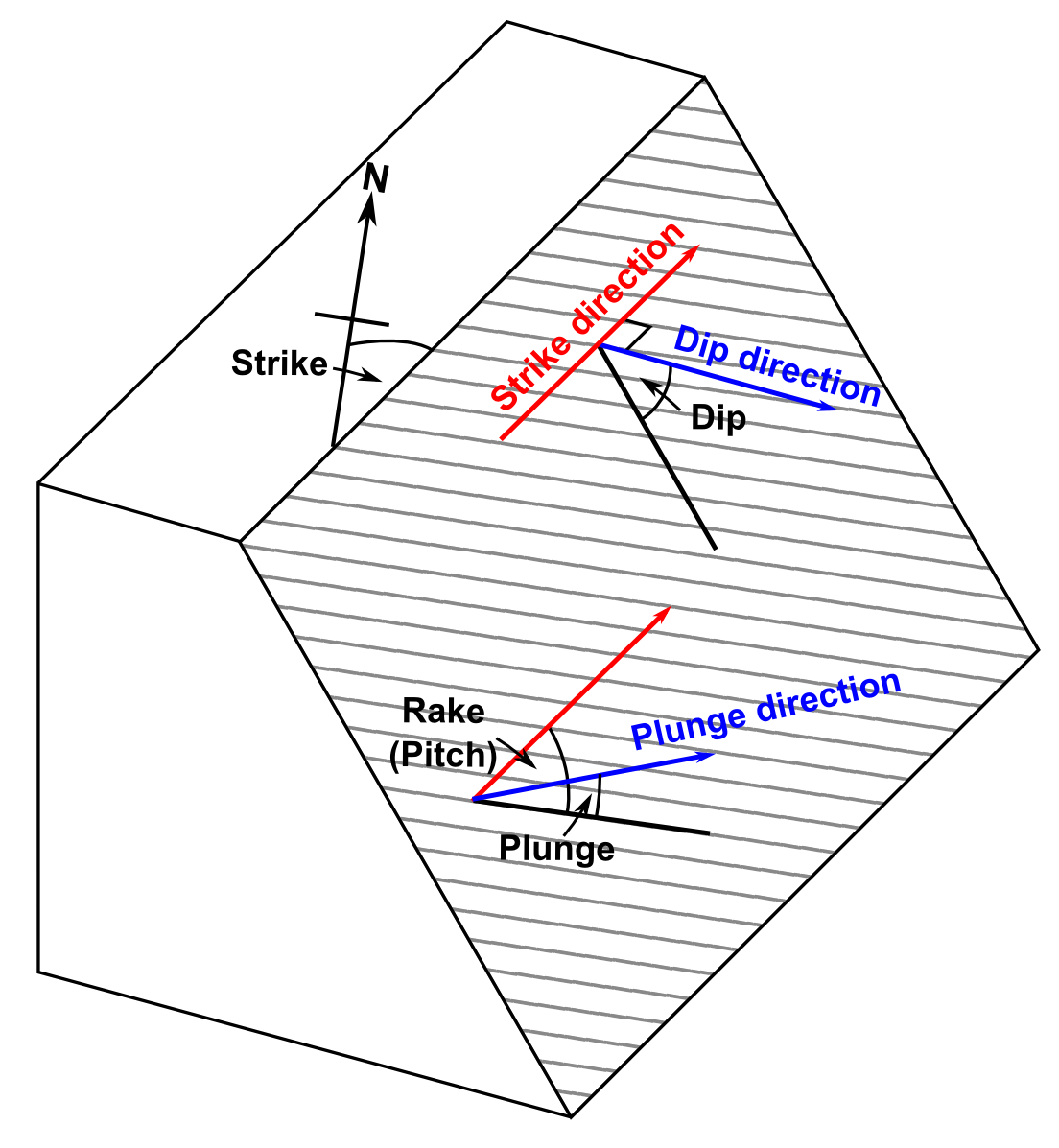
Important Terms in Measurement
- Trend: The direction of a horizontal line specified by its bearing or azimuth.
- Bearing: The horizontal angle measured east or west from the true north or south.
- Azimuth: The horizontal angle measured clockwise from the true north.
- Strike:the trend of a horizontal line on an inclined plane. It is marked by the line of the intersection with a horizontal plane. (Davis & Reynolds, 1996).
- Inclination: Theverticalangle, measureddownwardfromthehorizontaltoa slopingplaneorline.
Fracture
In geology, a fracture is a crack or break in a rock that does not involve significant movement or displacement of the rock on either side of the crack. Fractures can occur in any type of rock and can range in size from microscopic to tens of meters in length.
Fractures can form in a variety of ways. Some common causes of fractures include:
- Tectonic forces: Fractures can form in response to tectonic forces, such as compression or extension, that act on the rock.
- Cooling and contraction: Fractures can form in rocks that have cooled and contracted, causing them to crack.
- Erosion: Fractures can form due to erosion of the rock, such as by weathering, water, or wind.
- Expansion: Fractures can form due to expansion of the rock, such as from the growth of minerals or the absorption of water.
- Human activity: Fractures can also be caused by human activity, such as mining, drilling, or excavation.
Fractures can have important implications for geologic processes and human activities. For example, fractures can provide pathways for fluids such as water, oil, or gas to move through the rock. Fractures can also affect the strength and stability of rocks and can influence the behavior of landslides and earthquakes. In addition, fractures can provide clues about the geological history of a region and can be useful for mineral exploration and geotechnical engineering.
Emerson fault during the 28 June 1992 Landers,
California, earthquake (Photo: Ramon
Arrowsmith).

and black shale within
the Utica Shale (Ordovician)
near Fort Plain, NewYork.
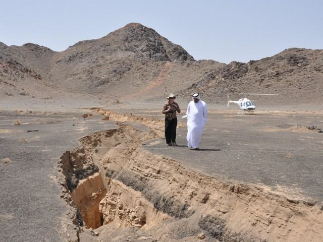
during the 19 May 2009 earthquake at
Lunayyir, Saudi Arabia. (Photo: John
Pallister).
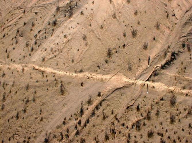
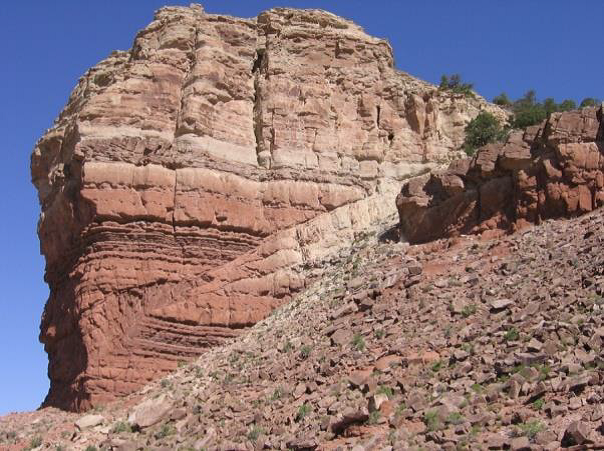
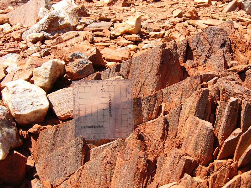
Joints
In geology, joints are natural fractures or cracks in rocks that occur without significant displacement or movement of the rock on either side of the crack. Joints can occur in any type of rock and can range in size from microscopic to several meters in length.
Joints are usually formed in response to stress, such as tectonic forces or cooling and contraction, and are typically oriented in a specific direction based on the direction of the stress. Joints can occur as single fractures, or as a set of parallel fractures that form a joint system.
Joints can have important implications for geologic processes and human activities. For example, joints can provide pathways for fluids such as water, oil, or gas to move through the rock, and can affect the strength and stability of rocks. Joints can also influence the behavior of landslides and earthquakes.
Joints are commonly used in geologic mapping and exploration for natural resources such as oil, gas, and minerals. They can also be important in engineering and construction, as they can affect the stability and strength of rock masses and the behavior of underground structures such as tunnels and mines.
Some common types of joints include:
- Columnar jointing: a type of jointing that occurs in igneous rocks, typically basalt, where the rock fractures in a pattern of vertical columns.
- Tensional joints: joints that form in response to tensile stress, such as those that occur in the upper part of a fault zone.
- Shear joints: joints that form in response to shear stress, such as those that occur along the boundary between two tectonic plates.
- Conjugate joints: two sets of joints that intersect at a particular angle, forming a “cross-hatched” pattern.
Overall, joints are an important aspect of structural geology and can provide valuable information about the history and behavior of rocks in the Earth’s crust.
and black shale within
the Utica Shale (Ordovician)
near Fort Plain, NewYork.
Faults
In geology, a fault is a planar fracture or break in rock where the two sides have moved relative to each other, resulting in displacement along the fault plane. Faults can occur at any depth in the Earth’s crust and can range in size from a few centimeters to thousands of kilometers in length.
Faults are commonly formed by tectonic forces, which cause rocks to deform and eventually break along a fault plane. When one side of the fault moves relative to the other side, this is known as fault slip or fault movement.
There are several types of faults, including:
- Normal faults: faults where the hanging wall moves downward relative to the footwall. Normal faults are associated with extensional tectonic forces.
- Reverse faults: faults where the hanging wall moves upward relative to the footwall. Reverse faults are associated with compressional tectonic forces.
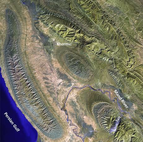
- Strike-slip faults: faults where the relative motion between the two sides of the fault is primarily horizontal. Strike-slip faults are associated with shear tectonic forces.
- Oblique-slip faults: faults where the relative motion between the two sides of the fault is a combination of horizontal and vertical movement.
Faults can have important implications for geologic processes and human activities. For example, faults can provide pathways for fluids such as water, oil, or gas to move through the rock, and can affect the strength and stability of rocks. Faults can also be the source of earthquakes, and their behavior can influence the potential for landslides and other geologic hazards.
Faults are commonly used in geologic mapping and exploration for natural resources such as oil, gas, and minerals. They can also be important in engineering and construction, as they can affect the stability and strength of rock masses and the behavior of underground structures such as tunnels and mines. Overall, the study of faults is an important aspect of structural geology and can provide valuable insights into the behavior and history of the Earth’s crust.
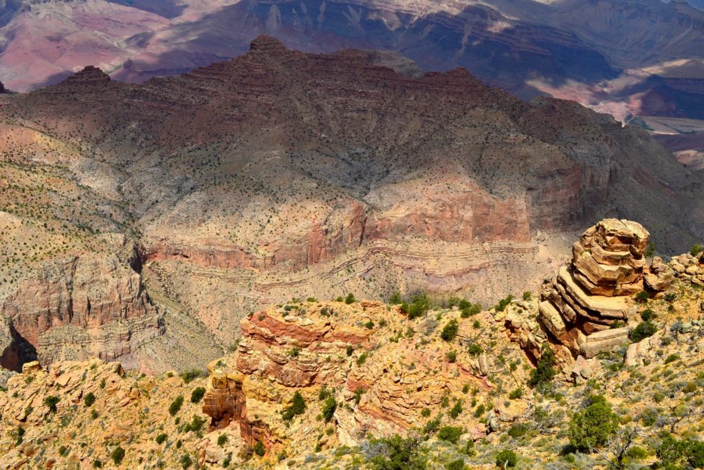
Macroscopic scale

system is a right lateral
strike-slip fault.
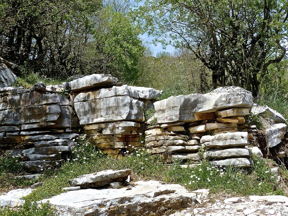
Mesocopic scale
sedimentary rock at Ketobe knob
along the San Rafael swell in
central Utah (Shortening occures;
Davis & Reynolds 1996).
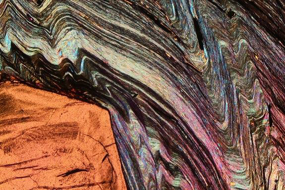
Microscopic scale

Salihli granodiorite cut by
microfaults; note bookshelf order
of feldspar fragments, (Hetzel
etal., 1995, JGSL)
Folds
In geology, a fold is a curved deformation or bend in rock layers that results from the application of tectonic forces or other stresses. Folds can occur at any depth in the Earth’s crust and can range in size from microscopic to several kilometers in length.
Folds are formed when rocks are subjected to compressional forces, such as those that occur when tectonic plates collide. The pressure causes the rock layers to buckle and bend, creating a fold. Folds can have a variety of shapes and sizes, depending on the orientation and magnitude of the applied stresses, as well as the properties of the rock.
Some common types of folds include:
- Anticlines: folds where the rock layers are bent upward, creating a “V” shape.
- Synclines: folds where the rock layers are bent downward, creating a “U” shape.
- Monoclines: folds where the rock layers are bent in a single direction, creating a step-like shape.
- Overturned folds: folds where the rock layers are bent to an extent that the original layering is no longer horizontal, but tilted or even overturned.
Folds can have important implications for geologic processes and human activities. For example, folds can provide clues about the history and evolution of a region, including the deformation that has occurred over time. Folds can also affect the behavior of groundwater and hydrocarbon reservoirs, and can be important in geologic exploration and resource extraction.
Folds are commonly used in geologic mapping and exploration for natural resources such as oil, gas, and minerals. They can also be important in engineering and construction, as they can affect the stability and strength of rock masses and the behavior of underground structures such as tunnels and mines. Overall, the study of folds is an important aspect of structural geology and can provide valuable insights into the behavior and history of the Earth’s crust.
Macroscopic scale
Mesocopic scale

Microscopic scale
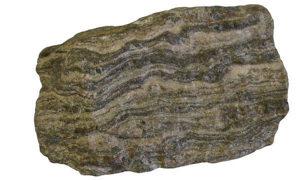
Foliation
Foliation is a type of geologic structure that refers to the repetitive layering or parallel alignment of minerals in a rock. Foliation is commonly observed in rocks that have undergone regional metamorphism, a process where rocks are subjected to high temperatures and pressures over a large area, resulting in the deformation and recrystallization of the original rock.
Foliation can take a variety of forms, depending on the orientation and arrangement of the mineral grains within the rock. Some common types of foliation include:
- Slaty foliation: a type of foliation characterized by the parallel alignment of fine-grained minerals, such as mica, resulting in a layered, slate-like appearance.
- Schistosity: a type of foliation characterized by the parallel alignment of larger mineral grains, such as quartz and feldspar, resulting in a coarse-grained, schist-like appearance.
- Gneissic banding: a type of foliation characterized by alternating layers of light and dark mineral bands, resulting in a banded, gneiss-like appearance.
Foliation can have important implications for the behavior and properties of rocks. For example, foliation can affect the strength and deformation behavior of rocks, as well as their permeability and ability to transmit fluids. Foliation can also provide important clues about the history and evolution of a region, including the tectonic forces and geologic processes that have affected the rocks over time.
Foliation is commonly used in geologic mapping and exploration for natural resources such as minerals and ores. It can also be important in engineering and construction, as it can affect the strength and stability of rock masses and the behavior of underground structures such as tunnels and mines. Overall, the study of foliation is an important aspect of structural geology and can provide valuable insights into the behavior and history of the Earth’s crust.
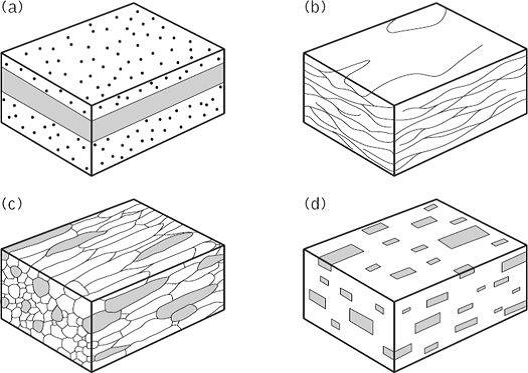

Lineation
Lineation is a type of geologic structure that refers to the linear or elongate features found in rocks. Lineations can take a variety of forms, including mineral elongation, striations, and grooves. Lineations are often used to determine the direction of tectonic forces that have affected the rocks.
Some common types of lineations include:
- Mineral elongation: a type of lineation where elongated minerals, such as amphiboles or feldspar, are aligned in a particular direction. Mineral elongation can be used to determine the direction of stress during deformation.
- Striations: a type of lineation characterized by grooves or scratches on the surface of a rock, usually formed by the movement of a glacier or other erosional process.
- Grooves: a type of lineation characterized by deeper, more pronounced marks on the surface of a rock, also usually formed by the movement of a glacier or other erosional process.
Lineations can provide important clues about the deformation history of rocks, as well as the orientation and magnitude of tectonic forces that have affected the rocks. Lineations can also be used in geologic mapping and exploration for natural resources such as minerals and ores, as they can provide information about the orientation and distribution of these resources.
Overall, the study of lineations is an important aspect of structural geology and can provide valuable insights into the behavior and history of the Earth’s crust.

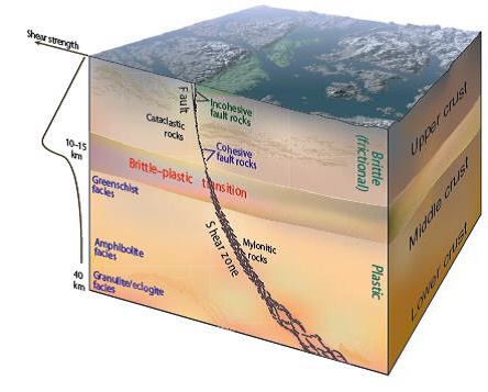
Shear zones
A shear zone is a type of geologic structure that forms when rocks are subjected to intense shear stresses, causing them to deform and fracture along a narrow zone. Shear zones can be identified by the presence of a characteristic pattern of closely spaced fractures and faults, often with a distinct orientation or alignment.
Shear zones are commonly associated with tectonic activity, such as the collision of tectonic plates, and can occur at various depths in the Earth’s crust. They can also be formed by other processes, such as the movement of glaciers or the flow of molten rock.
The deformation in a shear zone is typically focused along a narrow zone, resulting in a high degree of strain and deformation within the rocks. This can result in a variety of structures, such as fault breccia, mylonites, and cataclasites, which are characterized by the presence of fine-grained, sheared rock.
Shear zones can have important implications for a variety of geologic processes and activities. For example, shear zones can affect the behavior of groundwater and hydrocarbon reservoirs, and can be important in geologic exploration and resource extraction. Shear zones can also play a role in the stability of rock masses and the behavior of underground structures such as tunnels and mines.
Overall, the study of shear zones is an important aspect of structural geology and can provide valuable insights into the behavior and history of the Earth’s crust.
Symbology in structural geology
Symbolism in structural geology refers to the use of symbols and graphical representations to convey information about the orientation, geometry, and other properties of geologic structures. Symbolism is commonly used in geologic mapping and exploration, as well as in scientific research and education.
Some common symbols used in structural geology include:


- Strike and dip symbols: These symbols are used to indicate the orientation of geologic structures, such as beds, faults, and folds. The strike symbol is a short line perpendicular to the direction of the strike, and the dip symbol is a line with an arrow pointing in the direction of dip.
- Arrow symbols: These symbols are used to indicate the direction and magnitude of various forces, such as stress or strain. Arrows may be used to indicate the direction of fault movement, for example.
- Symbology for folds: Different types of folds can be represented by different symbols. For example, an anticline may be represented by a series of small triangles pointing in one direction, while a syncline may be represented by a series of small triangles pointing in the opposite direction.
- Symbology for lineations: Different types of lineations, such as mineral elongation or striations, can be represented by different symbols, such as elongated ovals or parallel lines.
Symbolism in structural geology is an important tool for communicating complex information about geologic structures in a clear and concise manner. It is also a valuable tool for scientific research, as it allows researchers to record and analyze geologic data in a consistent and standardized manner. Overall, symbolism plays a critical role in the field of structural geology and is an essential skill for geoscientists working in this field.


