


")


The San Andreas Fault is one of the most famous geological features in the world. It is a major transform fault located in California, USA, and is well-known for its historical significance in the study of plate tectonics and its potential to generate large earthquakes. In this introduction, we’ll explore the definition, location, and historical significance of the San Andreas Fault.

The San Andreas Fault is a transform fault, which is a type of geological fault where two tectonic plates slide past each other horizontally. In the case of the San Andreas Fault, it marks the boundary between two major tectonic plates: the Pacific Plate and the North American Plate. These plates are part of the Earth’s lithosphere, and their movement is responsible for shaping California’s geology and landscape.
Location:
The San Andreas Fault extends approximately 800 miles (1,300 kilometers) through California. It stretches from the southern part of the state, near the Salton Sea, all the way up to the northern region, near Cape Mendocino. It traverses a diverse range of landscapes, including deserts, mountains, and coastal areas, making it a prominent geological feature in California.

Historical Significance:
- Plate Tectonics Confirmation: The San Andreas Fault played a pivotal role in confirming the theory of plate tectonics, which revolutionized the field of geology in the mid-20th century. It provided tangible evidence of the movement of Earth’s lithospheric plates, as it clearly demonstrates the lateral movement of the Pacific and North American Plates.
- Large Earthquakes: The San Andreas Fault is notorious for producing large and destructive earthquakes. Some of the most significant earthquakes in California’s history, including the 1906 San Francisco earthquake, have been associated with this fault. These events have had a profound impact on the region’s development and seismic hazard awareness.
- Seismic Hazard: California is one of the most seismically active regions in the United States, and the San Andreas Fault is a primary source of this activity. Its presence has prompted extensive research and preparedness efforts to mitigate the potential impacts of future earthquakes. It has also influenced building codes and infrastructure development in the state.
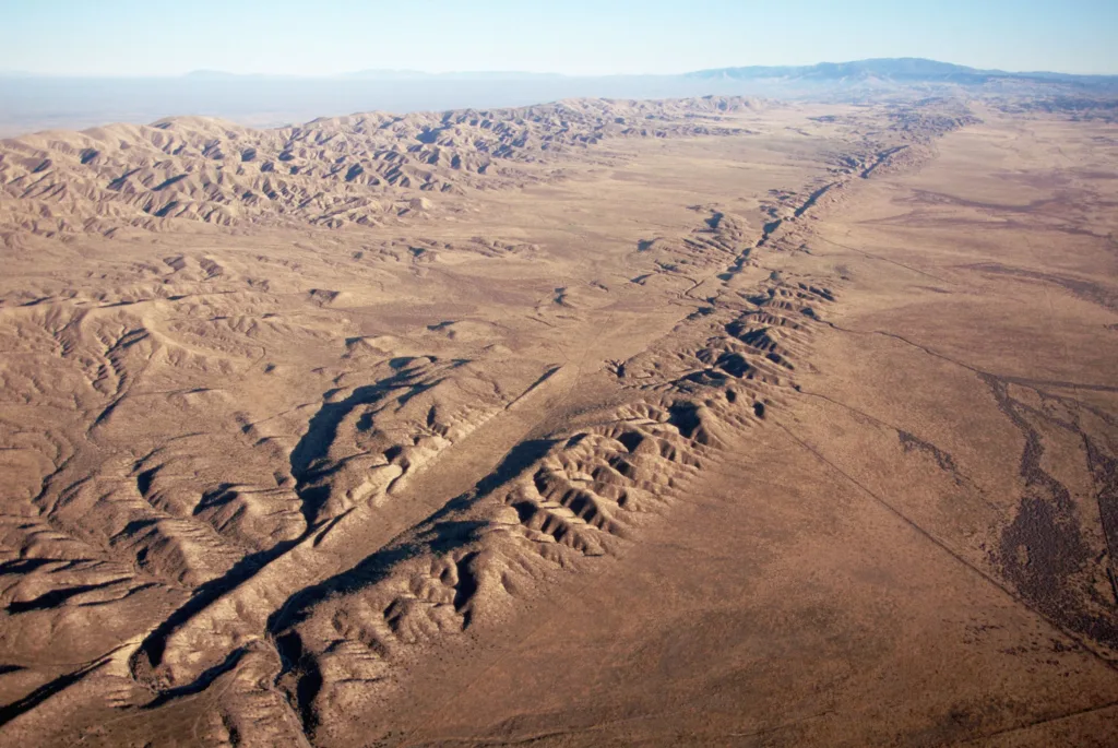
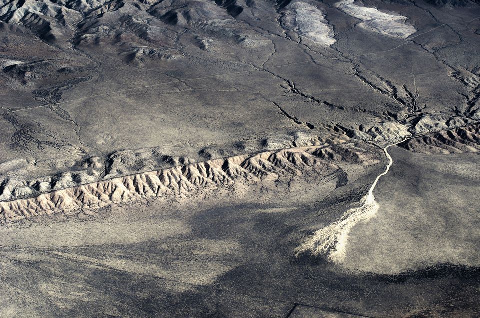
- Geological Features: The fault has created striking geological features, such as valleys, scarps, and offset streams, providing geologists with valuable insights into the history of the Earth’s crustal movements. These features have contributed to the field of geomorphology.
- Tourism and Education: The San Andreas Fault has become a tourist attraction and an educational resource. Visitors can explore areas where the fault is visible at the surface, such as the Carrizo Plain National Monument, and learn about the Earth’s dynamic processes.
In summary, the San Andreas Fault is a significant geological feature located in California, where the Pacific Plate and North American Plate interact. Its historical significance includes confirming the theory of plate tectonics, generating large earthquakes, influencing seismic hazard preparedness, shaping geological features, and serving as a source of education and tourism.
Geology of the San Andreas Fault
The San Andreas Fault is a complex geological feature with a rich history of tectonic activity. Its geology involves various elements, including tectonic plate boundaries, fault zones, fault segments, and branches. Let’s explore these aspects in more detail:
1. Tectonic Plate Boundaries:
The San Andreas Fault is primarily associated with the boundary between two major tectonic plates:
- Pacific Plate: To the west of the fault lies the Pacific Plate, which is an oceanic plate.
- North American Plate: To the east of the fault is the North American Plate, which is a continental plate.
The boundary where these plates meet is called a transform plate boundary. At this boundary, the plates slide horizontally past each other in opposite directions. The Pacific Plate moves northwest relative to the North American Plate.
2. Fault Zones:
The San Andreas Fault is not a single, continuous fault line but rather a complex system of interconnected fault zones. These fault zones accommodate the relative motion of the two plates. Some of the notable fault zones associated with the San Andreas Fault system include:
- San Andreas Fault Zone: This is the main fault zone and the one most commonly associated with the term “San Andreas Fault.” It runs for hundreds of miles from the Salton Sea in Southern California to Cape Mendocino in Northern California.
- Garlock Fault: Located to the south of the San Andreas Fault, the Garlock Fault is another significant fault zone that helps to accommodate the complex motion of the Pacific Plate relative to the North American Plate.
- San Jacinto Fault Zone: To the southeast of the San Andreas Fault, the San Jacinto Fault Zone is another important fault system that contributes to the region’s seismic activity.
3. Fault Segments and Branches:
Within the San Andreas Fault system, there are numerous fault segments and branches that exhibit varying degrees of activity and deformation. These segments and branches can be categorized based on their location and behavior:
- Locked Segments: Some segments of the fault are “locked,” meaning that stress is building up along them due to the plates being stuck. These locked segments have the potential to produce major earthquakes when the built-up stress is eventually released.
- Creeping Segments: In contrast, other segments are “creeping,” where the plates are sliding past each other continuously, but at a slower rate. These segments experience more gradual and less destructive motion.
- Branch Faults: There are also branch faults that connect to the main San Andreas Fault, adding complexity to the fault system. These branches can propagate seismic activity to different areas.
Overall, the San Andreas Fault system is a dynamic geological feature that reflects the ongoing interaction between the Pacific Plate and the North American Plate. Its complex network of fault zones, segments, and branches contributes to the seismic activity in California and continues to be a subject of study and monitoring for earthquake hazards.
History of the San Andreas Fault
The history of the San Andreas Fault is intertwined with the discovery of its existence, early knowledge, notable earthquakes, and its profound influence on California’s landscape. Let’s delve into these aspects:
1. Discovery and Early Knowledge:
- 1769: The first recorded sighting of the San Andreas Fault by Europeans occurred during the Portola expedition in 1769 when Gaspar de Portolà and his party observed a deep rift in the ground near the present-day city of Los Angeles. However, they didn’t understand the geological significance of what they had seen.
- 19th Century: The fault remained largely unknown and misunderstood throughout the 19th century, as early settlers and explorers were more focused on other aspects of California’s landscape and resources.
- Early 20th Century: The true nature of the San Andreas Fault and its role in earthquakes became evident in the early 20th century, particularly following the devastating 1906 San Francisco earthquake. This earthquake provided critical evidence that the fault was responsible for the seismic activity in the region.
2. Notable Earthquakes:
- 1906 San Francisco Earthquake: The 1906 earthquake is one of the most significant events in the history of the San Andreas Fault. It had a magnitude of approximately 7.9 and caused widespread destruction in San Francisco and the surrounding areas. This earthquake, which ruptured along a segment of the San Andreas Fault near San Francisco, resulted in significant loss of life and property damage.
- 1857 Fort Tejon Earthquake: This earthquake, with an estimated magnitude of 7.9, is one of the largest historical earthquakes known to have occurred along the San Andreas Fault. It caused surface ruptures and extensive damage to structures.
- Notable 20th and 21st Century Earthquakes: The San Andreas Fault has been the source of numerous earthquakes over the years, including smaller ones that contribute to California’s ongoing seismic activity. It remains a subject of active research and monitoring to understand and mitigate earthquake hazards.
3. Influence on California’s Landscape:
The San Andreas Fault has had a profound influence on California’s landscape in several ways:
- Creation of Geological Features: The fault’s movement over millions of years has shaped California’s landscape, creating valleys, mountains, and scarps. Notable features like the Carrizo Plain and the San Gabriel Mountains are a result of fault activity.
- Hydrology: The fault affects the flow of groundwater, resulting in springs and streams along its course. It also influences the distribution of aquifers and groundwater resources.
- Seismic Hazard Awareness: The fault’s seismic activity has had a lasting impact on the state’s infrastructure and urban planning. It has led to the development of stringent building codes and earthquake preparedness efforts to minimize the impact of future earthquakes.
- Tourism and Education: The San Andreas Fault has become a tourist attraction and an educational resource. Visitors can see the fault’s visible traces and learn about its geological significance.
In conclusion, the history of the San Andreas Fault involves its discovery, early understanding, notable earthquakes, and its significant influence on California’s landscape. It continues to be a focal point of scientific research, earthquake preparedness, and geological interest due to its dynamic nature and potential for seismic activity.
Conclusion
The San Andreas Fault is a prominent geological feature that has shaped the landscape of California and influenced the field of geology and seismology. Its complex system of fault zones, segments, and branches marks the boundary between the Pacific Plate and the North American Plate. The fault’s history includes early discovery, notable earthquakes, and a profound impact on California’s geography and infrastructure.
Summary of Key Points:
- The San Andreas Fault is a transform fault that runs approximately 800 miles through California, separating the Pacific Plate from the North American Plate.
- It was first observed by Europeans in 1769, but its geological significance became clear in the early 20th century, particularly after the devastating 1906 San Francisco earthquake.
- Notable earthquakes associated with the San Andreas Fault include the 1906 San Francisco earthquake, the 1857 Fort Tejon earthquake, and the 1989 Loma Prieta earthquake.
- The fault is divided into locked and creeping segments, with the locked segments accumulating stress that can lead to major earthquakes.
- Ongoing monitoring and research efforts help scientists understand fault behavior and assess seismic hazards.
- Earthquake preparedness in California includes building codes, infrastructure improvements, public education, and early warning systems.
Ongoing Importance of Studying the San Andreas Fault:
The study of the San Andreas Fault remains vital for several reasons:
- Seismic Hazard Mitigation: California is prone to earthquakes, and understanding the fault’s behavior is essential for mitigating the impact of future seismic events.
- Scientific Understanding: The fault offers insights into plate tectonics, the dynamics of the Earth’s crust, and geological processes.
- Public Safety: Continued research and monitoring help protect the lives and property of those living near the fault.
- Education and Tourism: The fault provides educational opportunities for scientists, students, and tourists interested in geology and Earth sciences.
Final Thoughts on Earthquake Preparedness:
Earthquake preparedness is crucial, especially in regions like California that are prone to seismic activity. Key steps for earthquake preparedness include:
- Building Codes: Ensuring that buildings and infrastructure are constructed or retrofitted to withstand earthquakes.
- Emergency Plans: Developing and practicing emergency plans for individuals, families, and communities.
- Early Warning Systems: Supporting and using early warning systems to provide advance notice of earthquakes.
- Public Education: Educating the public about earthquake risks, safety measures, and evacuation procedures.
- Infrastructure Resilience: Strengthening critical infrastructure, such as bridges and hospitals, to minimize damage during earthquakes.
- Community Engagement: Encouraging community involvement and preparedness efforts.
Ultimately, while we cannot predict when earthquakes will occur, preparedness measures can significantly reduce their impact and save lives. The study of fault systems like the San Andreas Fault contributes to our understanding of seismic hazards and informs these preparedness efforts.


