


")


Shark Bay is a unique and diverse World Heritage Site located on the western coast of Australia. It is known for its remarkable geological features, including stromatolites, saline flats, and stunning coastline. The geology of Shark Bay tells a story that spans millions of years and provides insights into the region’s geological history and formation.

The geological history of Shark Bay dates back to the Precambrian era, around 3.5 billion years ago. At that time, the region was a part of an ancient continental landmass. Over time, geological processes such as tectonic activity, erosion, and sedimentation shaped the area into what it is today.
One of the most significant geological events in Shark Bay’s history occurred during the Proterozoic era, around 2.4 billion years ago. It was during this time that microbial life, particularly cyanobacteria, began to flourish in the shallow marine environments of Shark Bay. These organisms played a crucial role in forming stromatolites, which are layered sedimentary structures created by the trapping and binding of sediment by microbial communities. Shark Bay is home to some of the world’s oldest and largest living stromatolites, providing valuable insights into the early history of life on Earth.
During the Paleozoic era, around 540 million years ago, Shark Bay was submerged under a shallow sea. The sediments deposited during this time eventually formed the Hamelin Pool Formation, which is rich in stromatolites and microbial mats.
As the geological timeline progressed into the Mesozoic era, around 250 million years ago, the supercontinent Pangaea began to break apart. This tectonic activity resulted in the separation of the Australian and Indian plates and the formation of the Indian Ocean. The coastline of Shark Bay was shaped by the rising and falling sea levels during this period, leaving behind ancient dune systems and sandstone cliffs.
In more recent times, during the Cenozoic era, around 66 million years ago, the sea levels fluctuated, and Shark Bay experienced periods of marine transgression and regression. The accumulation of sediments and the subsequent erosion shaped the diverse landscapes seen today, including the breathtaking Zuytdorp Cliffs and the Wooramel Seismic Zone.
The Shark Bay region also displays evidence of past climatic changes and geological phenomena. For instance, the presence of saline flats and hypersaline marine environments indicates a history of evaporative processes and the formation of salt deposits.
In conclusion, the geological history and formation of Shark Bay span billions of years, showcasing a rich and dynamic past. From ancient microbial communities that shaped stromatolites to tectonic activity and changing sea levels, the geology of Shark Bay offers a fascinating glimpse into the Earth’s geological evolution and the development of life.
Geological Features and Landforms
Shark Bay in Western Australia is renowned for its diverse and captivating geological features and landforms. Here, I will describe some of the major landforms found in Shark Bay, both along the coastline and inland.
Coastal Features:
- Beaches: Shark Bay boasts several beautiful sandy beaches, including Monkey Mia Beach, Shell Beach, and Herald Bight. These beaches are characterized by their pristine white sands and turquoise waters, offering visitors a picturesque coastal experience.
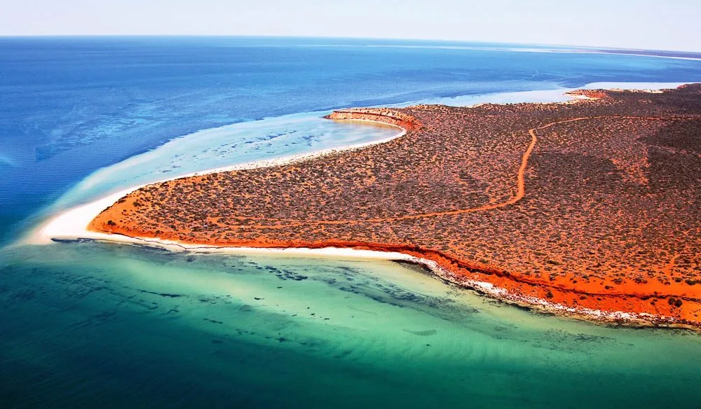
- Cliffs: The Zuytdorp Cliffs, located in the northern part of Shark Bay, are an impressive coastal feature. Rising up to 170 meters (550 feet) above sea level, these ancient limestone cliffs provide stunning panoramic views of the Indian Ocean.
- Dunes: Extensive sand dune systems can be found along the coast of Shark Bay. These dunes were formed by wind and wave action over millions of years. Some notable dune systems include the Francois Peron National Park and the Peron Heritage Precinct, where visitors can witness the unique flora and fauna adapted to the sandy environments.
Inland Features:
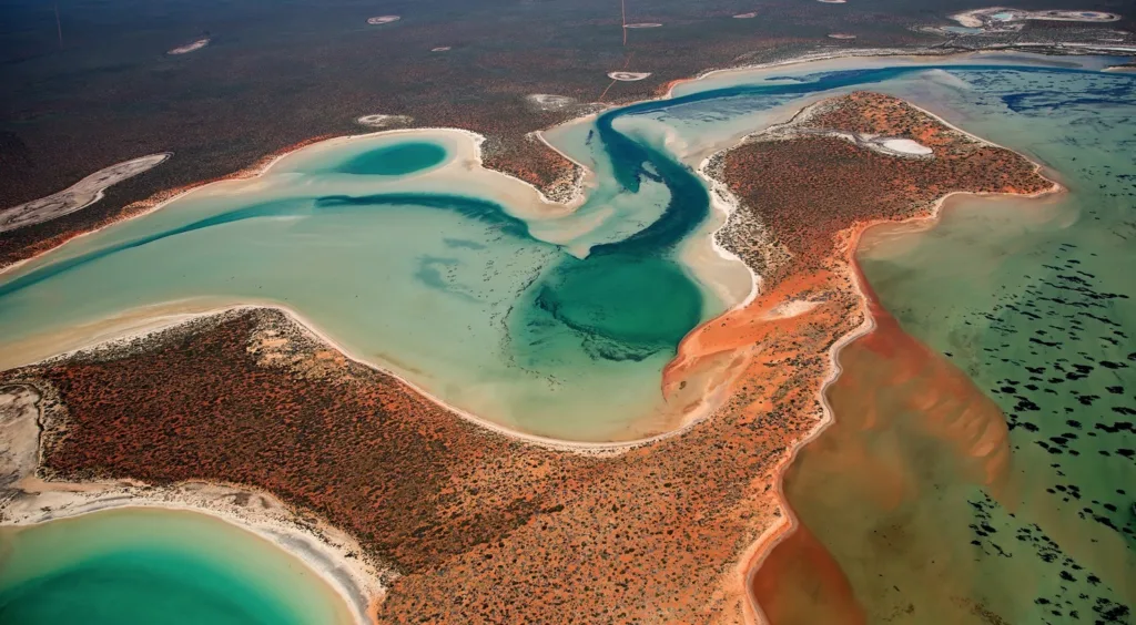
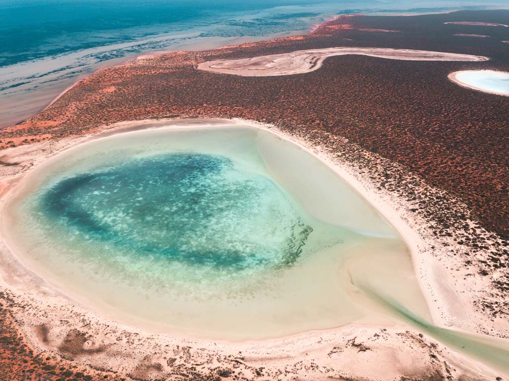
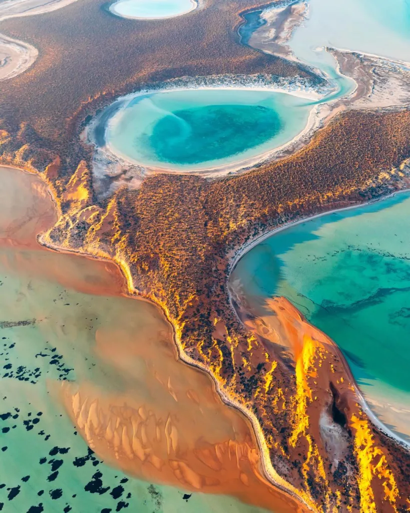
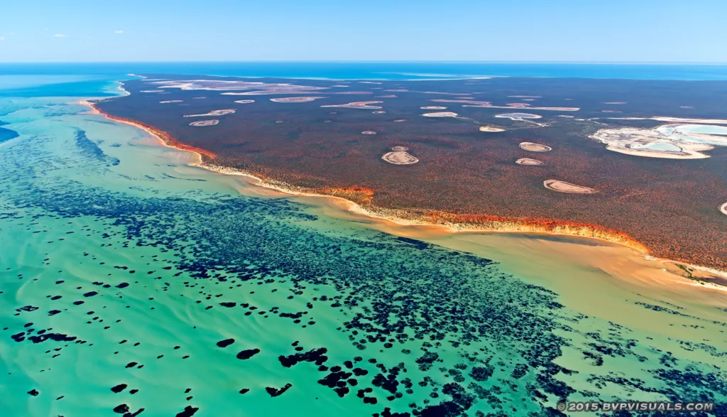
- Salt Pans: Shark Bay is home to expansive salt flats or pans, such as the Hamelin Pool and Useless Loop. These areas were formed through a combination of evaporation and sedimentation processes over thousands of years. The salt pans create a striking white landscape and provide habitat for unique organisms, including the famous stromatolites.
- Stromatolite Formations: Shark Bay is globally recognized for its living stromatolites, which are microbial mat structures formed by cyanobacteria. These structures can be observed at Hamelin Pool, where they thrive in the hypersaline conditions. Stromatolites offer valuable insights into the early history of life on Earth.
- Limestone Structures: Limestone is a prevalent rock type in Shark Bay, and it has given rise to various fascinating formations. One notable limestone feature is the “Pinnacles Desert” located in Nambung National Park, just outside the Shark Bay area. The Pinnacles are tall, limestone pillars rising from the sandy desert floor, creating a surreal and otherworldly landscape.
- Fossil Shell Banks: Shell Beach, located near the town of Denham, is an exceptional landform made up entirely of shells. It stretches for approximately 110 kilometers (68 miles) and consists of billions of tiny shells of the cockle species. The shells accumulated over thousands of years and created a unique and remarkable coastline.
These are just a few examples of the diverse geological features and landforms that can be found in Shark Bay. From stunning beaches and cliffs to salt pans, stromatolite formations, and limestone structures, the region offers a captivating blend of natural wonders and geological history.
Coastal Processes and Land Evolution
Coastal processes play a significant role in shaping the landforms and land evolution in Shark Bay. Here’s an overview of coastal erosion and deposition processes, the impact of tides, waves, and currents, as well as the influence of longshore drift on shoreline changes.
- Coastal Erosion and Deposition: Coastal erosion is the wearing away of land along the shoreline, while deposition refers to the accumulation of sediments. In Shark Bay, erosion and deposition occur due to various factors, including wave action, wind, and tidal forces.
Wave erosion: Powerful ocean waves, especially during storms, can erode the shoreline by removing sediments and wearing down cliffs or coastal bluffs. This erosion contributes to the formation of sea caves, notches, and platforms along the coast.
Wind erosion: Wind can transport loose sand and sediment from beaches and dunes, leading to the formation of sandbars and dune migration.
Deposition: Sediments carried by rivers and currents can be deposited along the coast, contributing to the formation of beaches, sandbars, and barrier islands.
- Impact of Tides, Waves, and Currents: Tides: Shark Bay experiences semi-diurnal tides, with two high tides and two low tides occurring each day. Tidal forces influence the movement of water, leading to erosion and deposition processes. During high tides, coastal erosion may occur as waves reach farther inland, while during low tides, deposition may take place as sediments settle.
Waves: Waves generated by wind are a primary force shaping Shark Bay’s coastline. Their energy can erode the shoreline, particularly where cliffs or bluffs are present. The intensity and direction of wave action influence the rate of erosion and deposition along the coast.
Currents: Longshore currents, driven by waves approaching the shoreline at an angle, play a crucial role in coastal processes. These currents transport sediments along the coast, resulting in the phenomenon known as longshore drift.
- Longshore Drift and Shoreline Changes: Longshore drift is the process by which sediments are transported along the coastline due to the oblique approach of waves. As waves strike the shoreline at an angle, they carry sediments in a zigzag pattern along the coast. This movement of sediments contributes to both erosion and deposition processes.
Longshore drift can lead to the formation of spits, sandbars, and barrier islands as sediments accumulate. However, it can also cause changes to the shoreline over time. For example, if there is a dominant longshore drift in one direction, sediments may be carried away from an area, leading to erosion. Conversely, deposition can occur in areas where sediments accumulate due to changes in wave direction or the presence of barriers.
Overall, the combined effects of tides, waves, currents, and longshore drift play a significant role in shaping the landforms and influencing the evolution of Shark Bay’s coastal areas. It is an ongoing process that results in both erosion and deposition, contributing to the dynamic nature of the region’s shoreline.
Sedimentary Deposits and Geological Formations
Shark Bay in Western Australia is characterized by a diverse range of sedimentary deposits and geological formations. Here’s an overview of the sedimentary deposits in Shark Bay, as well as the formation of sand dunes, sandbars, beach ridges, and key geological formations like the Tamala Limestone and Zuytdorp Cliffs.
- Sedimentary Deposits: Shark Bay has a rich accumulation of sedimentary deposits resulting from various geological processes. These deposits include:
- Sand: The region is known for its extensive sand dune systems, which are primarily composed of quartz sand. Wind-driven processes transport and deposit sand particles, shaping the dune formations.
- Mud and Clay: Sediments rich in mud and clay can be found in the sheltered areas of Shark Bay, such as shallow embayments and estuaries. These sediments are often associated with calm water conditions and the deposition of fine particles.
- Shell Deposits: Shell fragments and accumulations can be observed in areas like Shell Beach, where billions of tiny cockle shells have formed a distinct landform. Shell deposits also contribute to the overall sedimentary composition of Shark Bay.
- Sand Dunes, Sandbars, and Beach Ridges: Shark Bay’s coastal areas exhibit dynamic formations influenced by wind and wave action:
- Sand Dunes: The dune systems in Shark Bay are formed through the accumulation of wind-blown sand. Prevailing winds carry sand particles from the beach and deposit them inland, resulting in the development of dunes with characteristic shapes and sizes. These dunes play a crucial role in stabilizing the coastline and protecting the land from erosion.
- Sandbars: Sandbars are submerged or partially exposed ridges of sand that form parallel to the coastline. They are typically created by longshore drift, with waves carrying and depositing sediments in offshore areas. Sandbars can influence wave action and contribute to the formation of barrier islands and lagoons.
- Beach Ridges: Beach ridges are formed by the continuous deposition of sediments along the shoreline. Over time, multiple ridges can develop, reflecting changes in sea level and wave patterns. These ridges are often composed of sand and shell fragments and can be observed in Shark Bay’s coastal areas.
- Geological Formations: Two notable geological formations in Shark Bay are the Tamala Limestone and Zuytdorp Cliffs:
- Tamala Limestone: The Tamala Limestone is a prominent geological formation found along the coastline of Shark Bay. It consists of ancient limestone deposits that were formed in shallow marine environments. The Tamala Limestone is characterized by its porous nature and distinctive white color, contributing to the stunning coastal landscapes in the region.
- Zuytdorp Cliffs: The Zuytdorp Cliffs are towering limestone cliffs located in the northern part of Shark Bay. These cliffs rise up to 170 meters (550 feet) above sea level and extend for several kilometers. The Zuytdorp Cliffs were formed through the accumulation of marine sediments and subsequent geological processes over millions of years. They offer breathtaking views of the Indian Ocean and provide valuable insights into the geological history of the area.
These sedimentary deposits and geological formations in Shark Bay contribute to the unique landscapes and diverse geological history of the region, making it a fascinating area for geological exploration and study.
Geological Processes and Geological Time Scale
Geological processes are the fundamental mechanisms that shape the Earth’s surface and are responsible for the formation of various landforms and geological features. Here are some key geological processes and an overview of the geological time scale:
- Tectonic Processes: Tectonic processes involve the movement and interaction of Earth’s lithospheric plates. These processes include:
- Plate Tectonics: The theory of plate tectonics explains the movement of Earth’s rigid outer shell, or lithosphere, which is divided into several large plates. Interactions at plate boundaries, such as divergent, convergent, and transform boundaries, result in volcanic activity, earthquakes, mountain building, and the formation of oceanic trenches.
- Weathering and Erosion: Weathering is the breakdown of rocks at or near the Earth’s surface, while erosion is the transport and removal of weathered materials by wind, water, ice, or gravity. These processes contribute to the wearing down of mountains, the formation of river valleys, and the creation of sedimentary deposits.
- Sedimentation and Deposition: Sedimentation refers to the settling and accumulation of sediments, including rocks, minerals, and organic matter. Deposition occurs when sediments are laid down in new locations, often in bodies of water, leading to the formation of sedimentary rock layers.
- Diagenesis and Lithification: Diagenesis refers to the physical and chemical changes that occur to sedimentary rocks after deposition but before they become metamorphic rocks. Lithification involves the compaction and cementation of sedimentary particles, resulting in the hardening of sediments into solid rock.
- Metamorphism: Metamorphism is the process by which rocks undergo physical and chemical changes due to high temperature, pressure, or fluid activity. This process occurs within the Earth’s crust and can result in the formation of metamorphic rocks with new mineral assemblages and textures.
- Igneous Processes: Igneous processes involve the formation and solidification of molten rock, or magma. These processes include volcanic activity, where magma erupts onto the Earth’s surface as lava, and intrusive activity, where magma solidifies underground, forming intrusive igneous rocks.
Geological Time Scale: The geological time scale is a chronological representation of Earth’s history, divided into different periods, epochs, and ages. It provides a framework for understanding the sequence of geological events and the development of life on Earth. The time scale is divided into four major eons:
- Hadean Eon: This is the earliest eon, dating from the formation of the Earth about 4.6 billion years ago to around 4 billion years ago. It is characterized by intense volcanic activity, the formation of the oceans, and the early stages of Earth’s development.
- Archean Eon: The Archean eon spans from around 4 billion to 2.5 billion years ago. During this time, the Earth’s crust formed, and the first signs of life appeared, including single-celled organisms and stromatolites.
- Proterozoic Eon: The Proterozoic eon lasted from about 2.5 billion to 541 million years ago. It witnessed the diversification of life, the formation of oxygen-rich atmospheres, the emergence of complex organisms, and significant geological events, including the assembly and breakup of supercontinents.
- Phanerozoic Eon: The Phanerozoic eon began around 541 million years ago and continues to the present day. It is divided into three eras: the Paleozoic, Mesozoic, and Cenozoic. This eon is characterized by the proliferation of complex life forms, including plants, animals, and humans
Geomorphology and Landscape Evolution Geological Hazards and Natural Disasters
Geomorphology and Landscape Evolution: Geomorphology is the study of the Earth’s landforms, their origins, development, and change over time. It involves understanding the processes that shape the Earth’s surface and the evolution of landscapes. Here are some key concepts related to geomorphology and landscape evolution:
- Landform Development: Geomorphologists study the formation of landforms such as mountains, valleys, plateaus, plains, and coastal features. They examine the processes, such as weathering, erosion, deposition, and tectonic activity, that shape and modify these landforms over time.
- Fluvial Systems: Fluvial systems refer to the study of rivers and their interaction with the surrounding landscape. Geomorphologists analyze river processes, such as erosion, transport, and deposition of sediment, as well as the formation of river valleys, meanders, and deltas.
- Glacial and Periglacial Landforms: Geomorphologists study the effects of glaciers and cold climates on landscapes. Glacial landforms include moraines, cirques, U-shaped valleys, and fjords. Periglacial landforms, found in cold regions near glaciers, are characterized by freeze-thaw processes and include features like patterned ground and pingos.
- Karst Landscapes: Karst landscapes are formed in areas with soluble rock, such as limestone, where chemical weathering processes dissolve the rock and create distinctive landforms. Geomorphologists study features like sinkholes, caves, disappearing streams, and underground drainage systems in karst environments.
- Coastal Geomorphology: Coastal geomorphology focuses on the study of coastal landforms, including beaches, cliffs, dunes, estuaries, and coral reefs. Geomorphologists investigate the processes of coastal erosion, sediment transport, and sea-level changes, as well as the response of coastal environments to these processes.
Geological Hazards and Natural Disasters: Geological hazards and natural disasters are events or processes that pose a threat to human life, property, and the environment. They are often related to geological processes and can have significant impacts. Here are some examples of geological hazards and natural disasters:
- Earthquakes: Earthquakes occur when there is sudden release of energy along fault lines in the Earth’s crust. They can cause ground shaking, ground rupture, landslides, tsunamis, and secondary hazards like liquefaction and aftershocks.
- Volcanic Eruptions: Volcanic eruptions involve the release of molten rock, ash, gases, and pyroclastic materials from a volcano. They can cause ashfall, lava flows, pyroclastic flows, volcanic gases, lahars (mudflows), and volcanic landslides.
- Landslides: Landslides occur when a mass of rock, soil, or debris moves down a slope. They can be triggered by factors such as heavy rainfall, earthquakes, volcanic activity, or human activities. Landslides can damage infrastructure, block rivers, and cause loss of life and property.
- Tsunamis: Tsunamis are large ocean waves caused by underwater earthquakes, volcanic eruptions, or landslides. They can travel across oceans and cause extensive coastal flooding and destruction.
- Sinkholes: Sinkholes are depressions or collapses in the ground surface that occur due to the dissolution of soluble rock layers or the collapse of underground caverns. Sinkholes can cause damage to infrastructure and pose risks to human safety.
- Coastal Hazards: Coastal hazards include coastal erosion, storm surges, and flooding caused by severe weather events such as hurricanes, cyclones, and typhoons. They can result in property damage, coastal erosion, and displacement of
Tourism and Recreation
Tourism and recreation play a significant role in Shark Bay, attracting visitors from around the world who are drawn to the area’s unique natural and cultural attractions. Here’s an overview of tourism and recreational activities in Shark Bay:
- Marine and Coastal Activities: Shark Bay offers a diverse range of marine and coastal activities. Visitors can explore the World Heritage-listed Shark Bay Marine Park, which is home to stunning seascapes, vibrant coral reefs, and an abundance of marine life. Snorkeling, scuba diving, and swimming are popular activities, allowing visitors to observe colorful fish, dolphins, dugongs, and even the famous bottlenose dolphins of Monkey Mia.
- Wildlife Encounters: Shark Bay is renowned for its wildlife encounters. The Monkey Mia Reserve is particularly famous for its daily dolphin feeding experiences, where visitors have the opportunity to get up close to wild dolphins. Other wildlife encounters include interactions with turtles, rays, and a variety of bird species, including migratory shorebirds.
- Exploring the Coastal Landscapes: The diverse coastal landscapes of Shark Bay offer opportunities for exploration and adventure. Visitors can hike along scenic coastal trails, admire the towering cliffs, and enjoy panoramic views of the Indian Ocean. The Francois Peron National Park, located on the Peron Peninsula, is a popular destination for 4WD enthusiasts, offering rugged coastal tracks and stunning vistas.
- Cultural Experiences: Shark Bay is also rich in cultural heritage. Visitors can learn about the region’s Aboriginal history and traditions through guided tours and cultural experiences. The Malgana Aboriginal people, who have inhabited the area for thousands of years, share their knowledge and stories, providing visitors with a deeper understanding of the land and its significance.
- Camping and Outdoor Recreation: Shark Bay offers numerous camping and outdoor recreational opportunities. There are several campgrounds and caravan parks in the region, allowing visitors to immerse themselves in the natural beauty of the area. Fishing, boating, kayaking, and paddleboarding are popular activities, with various locations providing access to sheltered bays, estuaries, and fishing hotspots.
- Eco-Tourism and Conservation: Shark Bay is committed to sustainable tourism practices and environmental conservation. There are eco-tourism operators who offer guided tours focusing on the region’s unique ecosystems, including stromatolites, seagrass meadows, and marine sanctuaries. These tours emphasize the importance of environmental protection and conservation efforts.
It’s important for visitors to follow responsible tourism practices, including respecting the fragile ecosystems, adhering to wildlife viewing guidelines, and minimizing their environmental impact. By engaging in sustainable tourism, visitors can help preserve the natural beauty and cultural heritage of Shark Bay for future generations.
FAQs
What is the best time to visit Shark Bay?
The best time to visit Shark Bay is during the Australian summer months from December to February when the weather is warm and ideal for outdoor activities.
How do I get to Shark Bay?
Shark Bay can be reached by air through the Shark Bay Airport located near Monkey Mia. Alternatively, you can drive from Perth, which takes approximately 8-9 hours.
Can I swim with dolphins in Shark Bay?
Yes, visitors can have the opportunity to swim with wild dolphins in Monkey Mia. However, it is important to follow the guidelines set by the Department of Parks and Wildlife to ensure the well-being of the dolphins.
Are there camping facilities in Shark Bay?
Yes, there are several camping facilities and caravan parks available in Shark Bay, offering a range of amenities for visitors who wish to camp or stay in their own vehicles.
What is unique about the stromatolites in Shark Bay?
The stromatolites in Shark Bay are considered living fossils and are one of the oldest life forms on Earth. They provide valuable insights into the early evolution of life on our planet.
Are there any hiking trails in Shark Bay?
Yes, there are several hiking trails in Shark Bay, including the Francois Peron National Park and the Peron Heritage Precinct, offering opportunities to explore the coastal landscapes and observe wildlife.
Can I go fishing in Shark Bay?
Yes, fishing is a popular activity in Shark Bay. There are designated fishing areas, and visitors must adhere to fishing regulations and license requirements.
What is the significance of Shell Beach?
Shell Beach is a unique landform consisting of billions of tiny cockle shells instead of sand. It is one of only a few shell beaches in the world and offers visitors a remarkable sight.
Are there any accommodation options in Shark Bay?
Yes, Shark Bay provides various accommodation options, including hotels, resorts, motels, and self-contained apartments, catering to different budgets and preferences.
Is Shark Bay a World Heritage Site?
Yes, Shark Bay is a UNESCO World Heritage Site, recognized for its outstanding natural values, including its diverse marine ecosystems, stromatolites, and exceptional biological diversity.


