


")


Volcanic landscapes are some of the most mysterious, dramatic, and photogenic environments on the planet. For a geologist, these places are like an open-air laboratory shaped by molten rock rising from deep inside Earth. For a traveler or photographer, they are “the wildest place I’ve ever seen” moments. The truth is, every volcanic landscape is a story — a story of an eruption, a collapse, a lava flow, or long years of erosion carving strange shapes out of ancient ash and rock.
The ten places below represent the most spectacular volcanic formations on Earth. Each one has a geological timeline, an eruption history, a tectonic setting, and a formation process that makes it scientifically fascinating — but they’re also visually breathtaking even if you know nothing about geology.
Let’s dive into their full geological stories.
1. Mount Fuji – Japan
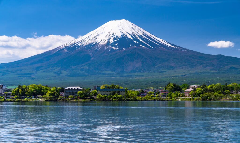
Volcano type: Stratovolcano
Height: 3,776 m
Age: ~100,000 years
Activity: Active; last eruption in 1707
Tectonics: Triple junction of Pacific, Philippine, and Amur plates
Mount Fuji is one of the most iconic stratovolcanoes in the world, famous for its near-perfect symmetry. That shape exists because Fujisan is built from repeating layers of lava, ash, and pyroclastic materials that accumulated in a balanced, consistent way over thousands of years.
Fuji is actually a three-stage composite volcano:
- Old Fuji (~100,000 years old)
- Middle Fuji (80,000–10,000 years ago)
- New Fuji (last 10,000 years)
The last major eruption — the Hoei eruption in 1707 — sent ash as far as Tokyo and dramatically reshaped the southeastern flank. Even though it’s been silent for over 300 years, magma still moves beneath the mountain, so “quiet” doesn’t mean “dead.”
What makes Fuji visually unforgettable is the combination of symmetry, the Fuji Five Lakes, morning fog rolling away from the base, and the orange glow of the volcano at sunrise or sunset. It’s not just a mountain — it’s an icon carved by fire.
2. Santorini Caldera – Greece
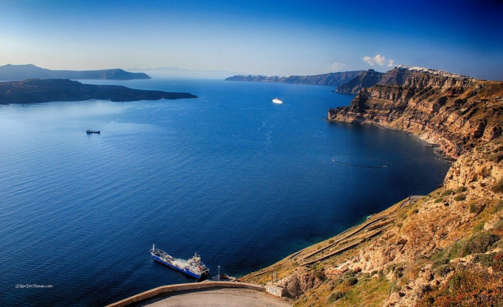
Volcano type: Caldera with remnant stratovolcano rims
Age: ~200,000 years
Activity: Active
Major eruption: Minoan eruption (~1600 BCE)
Tectonics: African Plate subducting beneath Eurasia
People see Santorini today as a postcard landscape with whitewashed houses and blue domes, but underneath that scenery lies the remains of a gigantic volcanic explosion. Around 3600 years ago, the Minoan eruption violently emptied the magma chamber and caused the entire volcanic center to collapse into the sea, forming the enormous caldera we see today.
The islands of Thira, Therasia, and Aspronisi are simply the steep caldera walls left behind. The two small islands in the center — Nea Kameni and Palea Kameni — are much younger volcanic domes that formed from repeated eruptions between the 1500s and 1950.
Geologically, Santorini is a perfect cross-section of volcanic layers: thick ignimbrites, welded tuffs, lava flows, and collapse structures all exposed in towering cliffs. Visually, it’s one of the most striking landscapes on Earth — a blend of volcanic destruction and human architecture.
3. Cappadocia Volcanic Province – Türkiye
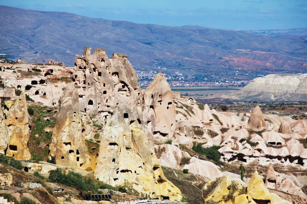
Volcano type: Ignimbrite plateaus, tuff cones, basalt caps
Age: 8 to 2 million years
Activity: Extinct
Source volcanoes: Erciyes, Hasan, Melendiz, Göllüdağ
Cappadocia looks like another planet. Those mushroom-shaped fairy chimneys and winding valleys were formed by huge volcanic eruptions from Central Anatolia’s paleo-volcanoes. Between 8 and 2 million years ago, the region was covered by massive ignimbrite sheets — hot, fast-moving clouds of volcanic ash and pumice that welded into thick tuff layers.
Over millions of years:
- soft tuff layers eroded easily,
- harder basalt and andesite blocks resisted erosion,
- and the famous “cap-rock” shapes emerged.
Erciyes may have experienced small Holocene eruptions, but overall the Cappadocia system is extinct today. Yet the volcanic layers remain like a detailed textbook — different colors and textures showing different eruption periods. It’s both a geological archive and a surreal piece of natural art.
4. Mount Kilimanjaro – Tanzania
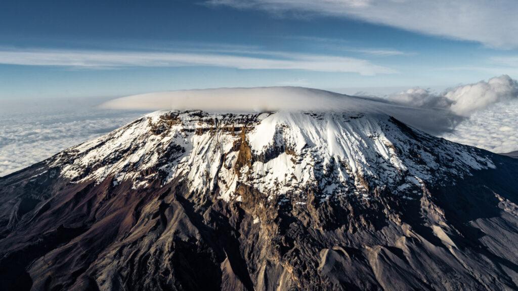
Volcano type: Stratovolcanic complex (Kibo, Mawenzi, Shira)
Age: 2.5 million – 150,000 years
Activity: Dormant but potentially active
Tectonics: East African Rift
Kilimanjaro is not a single volcano but a trio of volcanic centers rising from the East African Rift Zone:
- Shira (oldest, now a collapsed caldera),
- Mawenzi (jagged, deeply eroded),
- Kibo (youngest and still potentially active).
The East African Rift is literally tearing the continent apart. Magma rises through these stretched blocks of crust, forming massive volcanic edifices like Kilimanjaro. Fumaroles in Kibo’s crater floor show that heat still lingers beneath the summit.
What makes Kilimanjaro visually unique is the dramatic environmental staircase — tropical forests at the base, alpine deserts in the middle, and shrinking glaciers and permafrost at the summit. Those glaciers have lost more than 80% of their volume in the last century.
5. Iceland’s Basalt Columns – Reynisfjara & Svartifoss
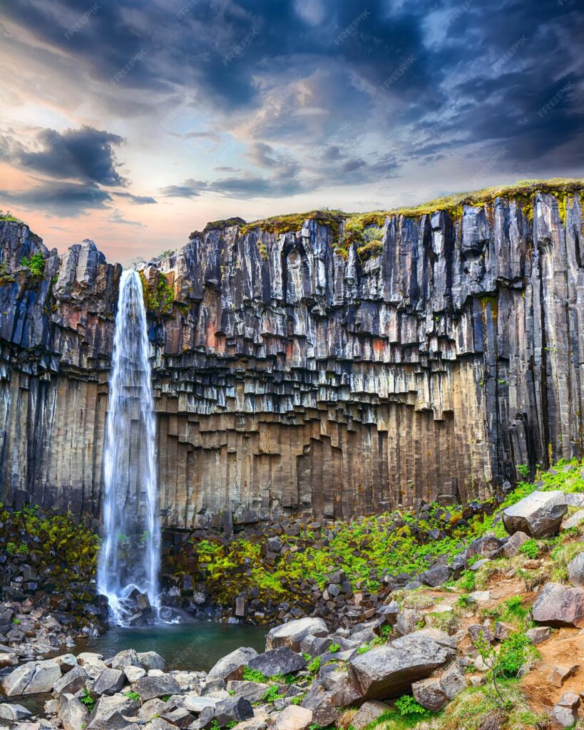
Volcano type: Basaltic lava flows
Age: Less than ~1 million years
Activity: Very active volcanic island
Tectonics: Mid-Atlantic Ridge spreading boundary
Reynisfjara’s hexagonal basalt columns form when thick basaltic lava cools slowly and contracts in a regular, geometric pattern. This process — columnar jointing — creates the honeycomb of long, vertical, almost artificial-looking pillars.
Iceland lies on top of both a spreading ridge and a mantle hotspot, so magma supply is constant and intense. Everywhere you go, you find lava flows, basalt cliffs, shield volcanoes, and geothermal fields.
Svartifoss, the “Black Waterfall,“ is framed by basalt columns that look carved by a sculptor. The interplay of the dark columns and white cascade makes it one of the most photographed volcanic waterfalls on Earth.
6. Mount Bromo – Indonesia
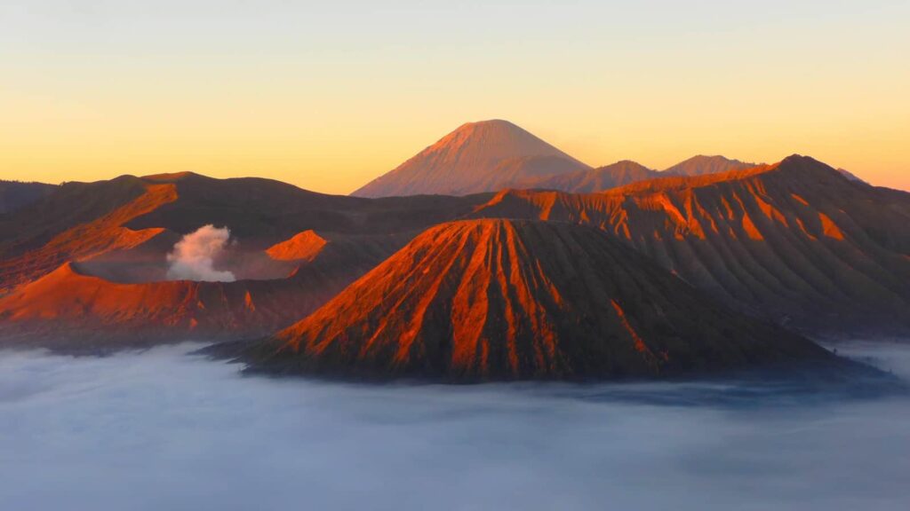
Volcano type: Active cone within the Tengger Caldera
Age: Tens of thousands of years
Activity: Very active
Tectonics: Australian Plate subducting beneath Sunda Plate
Mount Bromo sits inside the enormous Tengger Caldera — the remains of a massive ancient eruption. The wide grey “sea of sand” around it is actually fine volcanic ash, constantly redistributed by wind. At sunrise, when fog fills the caldera and Bromo’s steam plume rises into the colored sky, the scene looks unreal.
Bromo erupts frequently: 2010, 2011, 2015–16, and 2021 all saw significant activity. Indonesia, located along the Pacific Ring of Fire, experiences more volcanic eruptions than any other country in the world.
The harsh, moon-like caldera floor and the steep crater rim create one of the most cinematic volcanic landscapes on Earth.
7. Hawaii Volcanoes National Park – United States
Volcano type: Shield volcanoes (Mauna Loa, Kīlauea)
Age: Up to ~1 million years
Activity: Among the world’s most active
Tectonics: Hawaii Hotspot
Hawaii’s volcanism is unique because it does not occur at a plate boundary. Instead, a deep-mantle hotspot punches through the Pacific Plate, generating a chain of volcanic islands as the plate moves northwest.
Kīlauea, one of Earth’s most active volcanoes, produces constant lava flows that create new land almost every decade.
Mauna Loa, by volume, is the largest mountain on the planet — even bigger than Everest when measured from the seafloor.
Hawaiian lava is mostly basaltic, meaning very fluid and capable of creating long rivers of glowing lava instead of explosive eruptions. Walking across cooled pāhoehoe flows or watching lava pour into the ocean is like witnessing planet-building in real time.
8. Atacama Volcanic Belt – Licancabur & El Tatio (Chile–Bolivia)
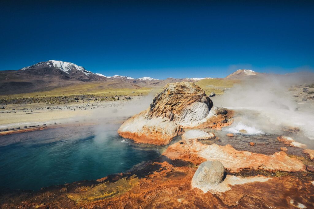
Volcano type: Stratovolcanoes and geothermal fields
Age: Millions of years
Activity: Some cones potentially active
Tectonics: Nazca Plate subducting beneath South America
The Atacama Desert is the driest non-polar region on Earth, and its volcanic cones stand almost perfectly symmetrical against a sky that feels twice as large as anywhere else. Licancabur is a classic stratovolcano — steep, clean lines, crowned by one of the world’s highest crater lakes.
Nearby El Tatio hosts one of the planet’s largest geyser fields. Here, volcanic heat warms groundwater, creating boiling pools, jets of steam, and colorful mineral deposits.
The combination of extreme dryness, volcanic gases, and high altitude gives the area a Mars-like atmosphere — which is why NASA actually tests instruments here.
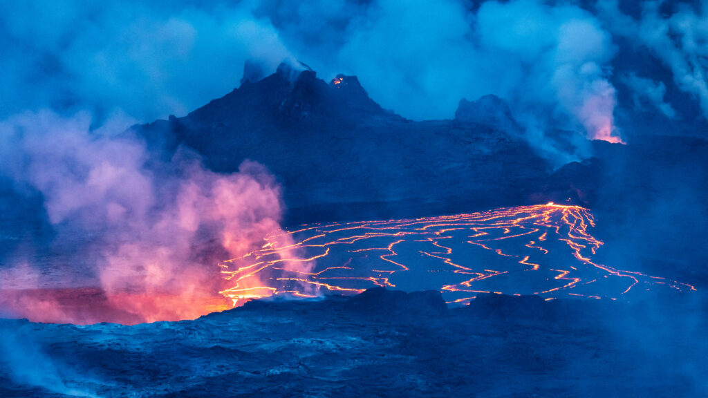
9. Mount Etna – Italy
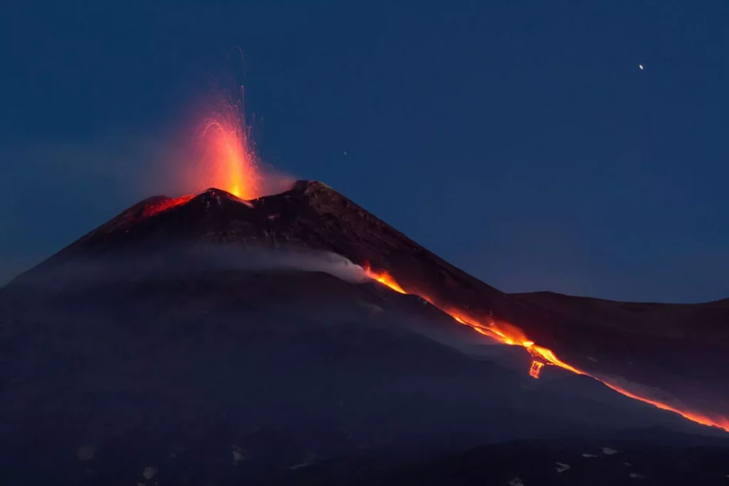
Volcano type: Stratovolcano
Age: ~500,000 years
Activity: Continuously active
Tectonics: African Plate colliding with Eurasia
Mount Etna is Europe’s most active volcano, erupting so frequently that the landscape changes almost yearly. Its complex magma plumbing system includes both deep mantle sources and shallow crustal reservoirs, making it capable of everything from lava fountains to explosive ash columns.
Etna’s slopes are covered with fertile volcanic soils, so vineyards, olive groves, and villages cling to the sides of an active volcano — a relationship as old as Mediterranean civilization.
From glowing summit craters to long lava flows at night, Etna is one of Earth’s most photogenic volcanic giants.
10. Rotorua & Taupo Volcanic Zone – New Zealand
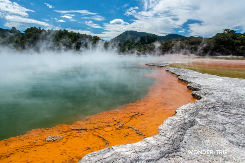
Volcano type: Rhyolitic calderas and geothermal fields
Age: Millions of years; last super-eruption ~26,500 years ago
Activity: Very active
Tectonics: Pacific–Australian plate boundary
The Taupo Volcanic Zone hosts the most powerful rhyolitic eruptions in Earth’s recent geological history. The Oruanui eruption (~26,500 years ago) created Lake Taupo and is considered the largest eruption on the planet in the last 70,000 years.
Rotorua, sitting above the same magma system, is famous for boiling mud pools, sulfur-rich lakes, steaming vents, and constant geothermal activity. The crust here is thin, hot, and restless — magma chambers sit unusually close to the surface.
Walking around Rotorua feels like walking above a living machine.
Conclusion
These ten volcanic landscapes are shaped by deep Earth processes — rising magma, explosive eruptions, collapsing calderas, slow-moving lava seas, and millions of years of erosion. Some are ancient, some still threaten to erupt tomorrow, and all of them reveal how dynamic our planet really is.


