


")


Nature has been shaping the Earth’s surface for billions of years. However, this shaping is not random, chaotic or unplanned. On the contrary; factors such as rock type, tectonic structure, climate, water, wind and time each work according to specific physical and chemical laws. Some results of these long and slow processes appear to the human eye as if they were “consciously designed.”
There are some rock landscapes that, at first glance, give the impression of a work of art rather than a geological formation. Fluid lines, perfect geometries, balanced proportions and strong color transitions distinguish these forms from ordinary rocks. However, this aesthetic effect arises not from nature’s intention to make art, but from the inevitable consequences of geological processes.
The following ten rock landscapes are the most striking examples showing how impressive geology can be not only scientifically but also visually. Each is the result of the patient work of millions of years of geological processes and represents the surface reflections of the dynamic forces on our planet.
1. The Wave – Arizona, USA
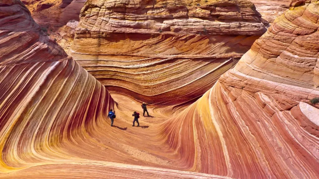
The Wave is one of the world’s most iconic rock formations with its red, orange and yellow bands that curve in wave form. The lines on the surface are as fluid as if they came from a painter’s brush, and the rock gives a feeling of frozen movement. Located in the Pariah Canyon-Vermilion Cliffs Wilderness area on the border between Arizona and Utah, this formation presents an almost surreal landscape with its smooth and undulating surfaces.
Geological Formation
The origin of this formation dates back approximately 190 million years to the Jurassic period. At that time, the region was covered with a vast desert system similar to the modern Sahara Desert. The dunes formed by the winds were buried over time, compressed and transformed into Navajo Sandstone. The sloping surfaces of the dunes have been preserved as cross-bedding within the rock.
The most important factor in The Wave achieving its current form is differential erosion. While wind and surface flow eroded the weaker layers, harder layers rich in iron oxide showed resistance. This selective erosion created wave-like grooves and ridges on the rock surface.
The colors result from different oxidation levels of iron carried by groundwater. Different forms of iron oxide create a color spectrum ranging from deep reds to pale yellows. Each color band represents a different geochemical environment and time. In this respect, The Wave is not only a visual masterpiece, but also a geological document describing the behavior of ancient desert systems.
2. Giant’s Causeway – Northern Ireland
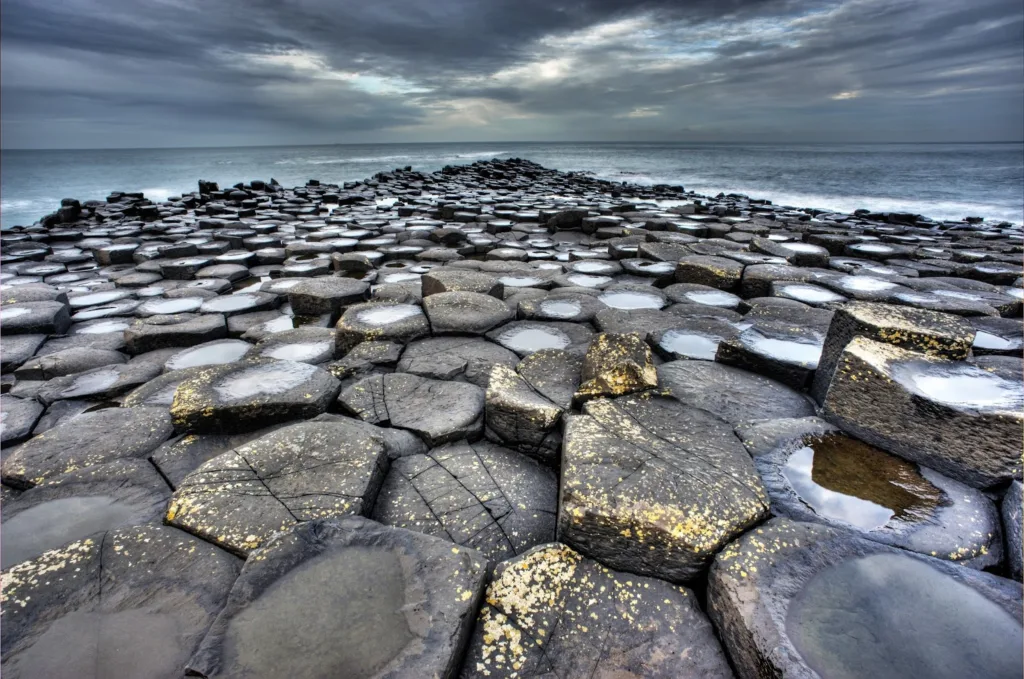
Giant’s Causeway presents an almost perfect geometric order formed by the coming together of approximately 40,000 polygonal basalt columns. These columns rise from the sea and form a natural pavement, extending from the coast to the cliffs. Although most columns are hexagonal, there are also those with four, five, seven or eight sides. The columns fit together so precisely that they appear almost artificial.
Geological Formation
Approximately 50-60 million years ago, during the Paleogene period, the region witnessed intense volcanic activity. Basaltic lavas erupting from cracks in the Earth’s crust spread to cover the region. Due to its low viscosity, basaltic lava can spread over large areas and turn into relatively thin, extensive layers.
When the lavas that reached the surface encountered the cool atmosphere and ocean water, they began to cool rapidly and experienced volume loss during cooling. This thermal contraction caused the lava to form regular cracks.
Since hexagons are physically the most efficient form of stress relief, cracks mostly developed in hexagonal patterns. This situation is similar to drying mud forming hexagonal cracks. Hexagons are the most stable geometric configuration that allows maximum stress relief with minimum crack length.
The diameters of the columns are a direct indicator of cooling rate. Thin columns formed in faster cooling areas, while thick columns formed in slower cooling areas. Over millions of years, erosion removed the overlying rock layers and exposed the columnar basalt. The wave action of the Atlantic Ocean further shaped and revealed the formation.
In this respect, Giant’s Causeway is a natural laboratory that clearly shows the cooling dynamics of lava flows and demonstrates how thermal stress is relieved in the most efficient way.
3. Zhangye Danxia – China
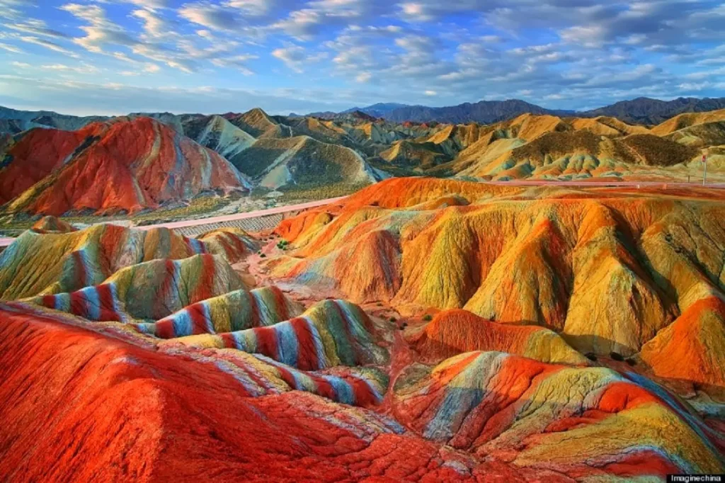
Zhangye Danxia Geological Park is known for its mountain ranges consisting of colorful layers. Red, orange, yellow and occasionally greenish tones spread across the landscape as if painted with broad brush strokes. The vibrant colors ripple in smooth, flowing patterns creating a striking visual effect. The colors become even more saturated especially at sunrise and sunset, taking on an almost surreal appearance.
Geological Formation
This colorful structure is the result of sedimentary deposition, tectonic uplift and erosion working together. The region was in the position of a large inland basin between 100 and 25 million years ago. Rivers carried and deposited different sediments containing various minerals. Red sandstone layers rich in iron oxide were deposited alternately with layers containing other minerals, forming the foundation of colorful stratigraphy.
The collision of the Indian and Eurasian tectonic plates not only created the Himalayan Mountains but also caused uplift throughout Central Asia. This uplift tilted and folded the originally horizontal sedimentary layers, creating dramatic angles and curves.
Different rock layers show different resistance to erosion. Harder layers form ridges and peaks, while softer layers erode more quickly to form valleys. This selective erosion emphasizes the colorful layering and reveals the dramatic topography.
Continued exposure to atmospheric conditions causes oxidation of iron-bearing minerals, maintaining and intensifying the red and orange colors. Different oxidation states and mineral compositions produce the range of hues visible today.
The result is a landscape where geological structure becomes visible art. Each color band represents a specific depositional environment and time period. In this respect, Zhangye Danxia is not only a visual feast but also a stone book for reading the geological history of the region.
4. Antelope Canyon – Arizona, USA

Antelope Canyon is a slot canyon known for its smooth, fluid walls. The walls curve and twist like frozen water. Light beams entering from the narrow opening above create dramatic light effects that change throughout the day. The sandstone walls display delicate color gradations from deep orange to pale pinkening, and the surface textures appear almost fluid.
Geological Formation
Antelope Canyon was carved through Navajo Sandstone over millions of years through a process dominated by flash flooding. The Colorado Plateau region receives intense but infrequent rainfall. When storms occur, water collects in drainage basins and funnels into narrow channels, creating powerful flash floods. These floods carry tremendous erosive energy concentrated in narrow spaces.
Fast-moving water creates pressure differentials that can literally pluck chunks from the rock walls. This process is most effective along natural weaknesses in the rock such as bedding planes and joints, and is known as hydraulic plucking.
Floods carry sand, gravel and boulders that act as cutting tools, abrading against the canyon walls. This abrasive effect polishes the rock surfaces and creates the characteristic smooth, flowing lines of slot canyons.
Water flowing through the sandstone dissolves the calcium carbonate cement between sand grains, weakening the rock and making it more susceptible to erosion. This chemical weathering works in concert with physical erosion.
The narrow width of the canyon concentrates erosive forces, allowing water to cut deep channels in a relatively short geological time frame. The smooth curves and flowing shapes are the result of water following the path of least resistance through the rock, creating naturally streamlined forms.
5. Marble Caves – Chile
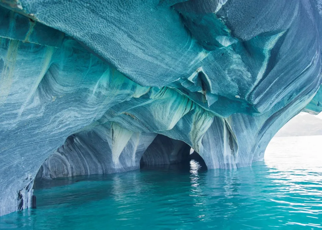
The Marble Caves form a series of natural caverns carved into pure marble along the shores of General Carrera Lake in Chilean Patagonia. The cave walls display swirling patterns of blue, gray and white marble, and the reflection of the turquoise lake water creates an ethereal blue glow throughout the caverns. The smooth, undulating surfaces create cathedral-like spaces with an almost perfect degree of naturalness.
Geological Formation
The Marble Caves formed through a specific sequence of geological processes. The parent rock began as limestone deposited in an ancient ocean. Approximately 300-400 million years ago, tectonic activity buried these limestone layers deep within the Earth’s crust. Here, heat and pressure transformed them into marble through the recrystallization of calcium carbonate.
Later tectonic activity uplifted the marble, bringing it back toward the surface and exposing it along the shores of General Carrera Lake. Since the last ice age, for approximately 6,000 years, lake waves have carved the marble. The pure calcium carbonate composition makes the marble relatively soft and susceptible to chemical and physical weathering.
Lake water, slightly acidic from dissolved carbon dioxide, slowly dissolves the calcium carbonate, creating smooth, flowing surfaces and enlarging natural cavities in the rock. The swirling blue colors result from the reflection of the turquoise lake water containing glacially-derived rock flour. This rock flour gives the water its characteristic color. The gray and white banding in the marble represents impurities and different crystallization episodes in the original metamorphic rock.
The caves continue to evolve; ongoing wave action and chemical weathering gradually change their form. The water level of the lake fluctuates seasonally, creating different erosion patterns at different elevations.
6. Fly Geyser – Nevada, USA
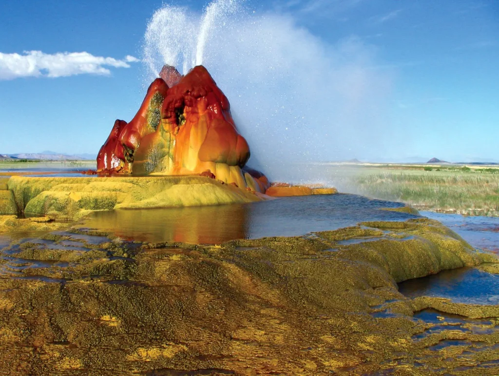
Fly Geyser is an otherworldly formation consisting of multiple mineral-encrusted spires from which water continuously flows. The mounds are covered in bright colors: reds, oranges, yellows and greens. The structure is like an alien landscape or a psychedelic sculpture. Steam continuously rises from the geyser, contributing to its surreal appearance.
Geological Formation
Unlike most formations on this list, Fly Geyser is partially anthropogenic, but the processes shaping it are entirely natural. In 1964, a geothermal energy company drilled an exploration well in the area. The well encountered a geothermal water source but was not properly sealed when abandoned.
Geothermally heated water under pressure began escaping through the improperly sealed well. The water comes from deep underground where it is heated due to proximity to magma chambers. The geothermal water is saturated with dissolved minerals; primarily calcium carbonate and silica. As the hot water reaches the surface and cools, these minerals precipitate out of solution, gradually building up the travertine mounds visible today.
Thermophilic (heat-loving) algae and cyanobacteria colonize the wet, mineral-rich surfaces. Different species thrive at different temperatures, creating vivid color gradations. Red and orange colors come from carotenoid pigments in algae, while greens come from chlorophyll.
The geyser remains active; water continuously flows and deposits new mineral layers. The formation grows taller over time and changes shape, making it a dynamic, evolving landscape. While the initial drilling was artificial, the spectacular mineral formations and colors are the result of natural geological and biological processes that would occur at any geothermal spring.
7. Moeraki Boulders – New Zealand
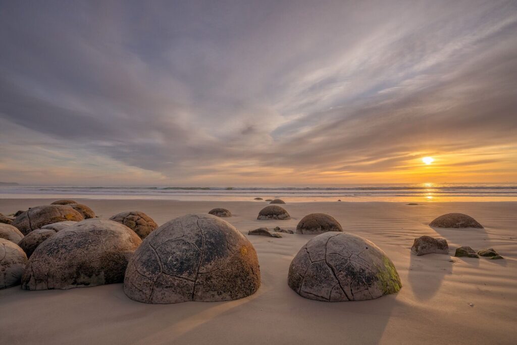
The Moeraki Boulders are large spherical stones scattered along Koekohe Beach on New Zealand’s South Island. These almost perfectly round rocks, some reaching up to 3 meters in diameter, lie on the beach like giant marbles. Many are cracked open, revealing crystalline structures inside. The geometric perfection of their spherical shape is striking against the organic forms of the surrounding landscape.
Geological Formation
The Moeraki Boulders are concretions that formed within the mudstone of the Moeraki Formation during the Paleocene epoch approximately 60 million years ago. The process began when small particles or organic matter on the ancient ocean floor became nucleation sites for mineral precipitation. These could have been shells, bones, or simply mineral grains.
Calcium carbonate dissolved in seawater precipitated in concentric layers around the nucleation points; this process is similar to how a pearl forms around an irritant in an oyster. This process occurred within the soft mudstone sediment.
The spherical geometry results from uniform precipitation rates in all directions from the center. This creates the most efficient geometric form for volume-to-surface-area ratio. The calcium carbonate cemented the sediment into extremely hard concretions while the surrounding mudstone remained relatively soft.
Over millions of years, coastal erosion gradually removed the soft mudstone, exposing the much harder concretions. The rocks that once formed within the cliff face now rest on the beach. Some rocks show internal chambers and radiating crystalline patterns. These formed when additional minerals precipitated in cavities or along cracks within the original concretion.
The precision of their spherical form demonstrates how geological processes can create remarkably regular geometric shapes through purely physical and chemical means.
8. Cappadocia – Turkey
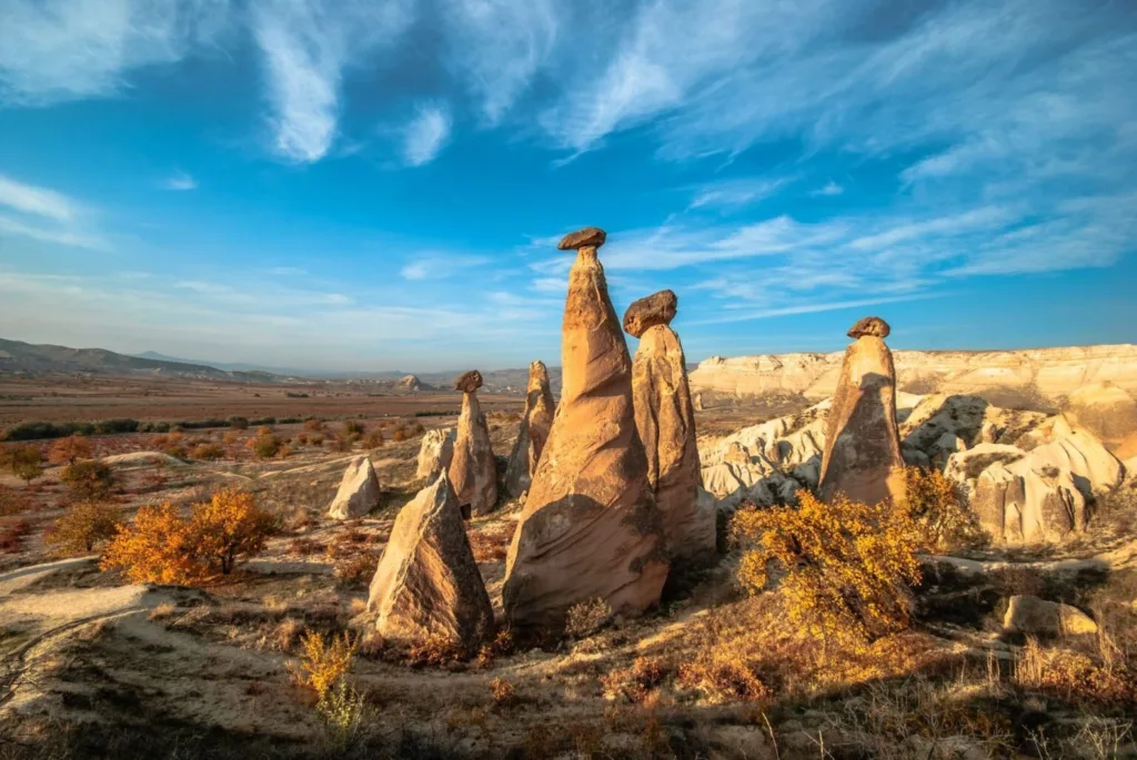
The Cappadocia region is known for its extraordinary cone-shaped rock formations called “fairy chimneys” or hoodoos. These towers, some reaching heights of 40 meters, have harder rock caps on top, giving them a mushroom-like appearance. The soft, pale stone is riddled with carved dwellings and churches, creating a unique blend of natural and human-modified landscape.
Geological Formation
Cappadocia’s distinctive landscape is the result of volcanic activity followed by selective erosion. Between 9 and 3 million years ago, nearby volcanoes erupted repeatedly, covering the region with thick layers of ash and tuff (consolidated volcanic ash). Lava flows were occasionally interspersed between the ash layers.
The volcanic deposits created a distinctive layered structure with softer tuff layers beneath harder basalt caps. The tuff layers consist of fine volcanic ash that consolidated into relatively soft rock.
Wind, rain and temperature fluctuations gradually erode the soft tuff, but at different rates depending on rock resistance. The harder basalt caps protect the tuff directly beneath them, while surrounding unprotected tuff erodes more quickly.
As erosion continues, protected columns of tuff remain standing with their protective basalt caps intact, creating the distinctive mushroom-like profiles. Eventually, the caps fall off and the remaining tuff erodes more rapidly. The landscape continues to change. New fairy chimneys form as erosion exposes previously protected tuff, while older chimneys gradually disappear as they lose their protective caps.
The region’s pale colors result from the volcanic ash composition, while iron oxide staining creates subtle color variations. The soft rock has also allowed humans to carve extensive networks of dwellings, monasteries and underground cities into the formations.
9. Chocolate Hills – Philippines
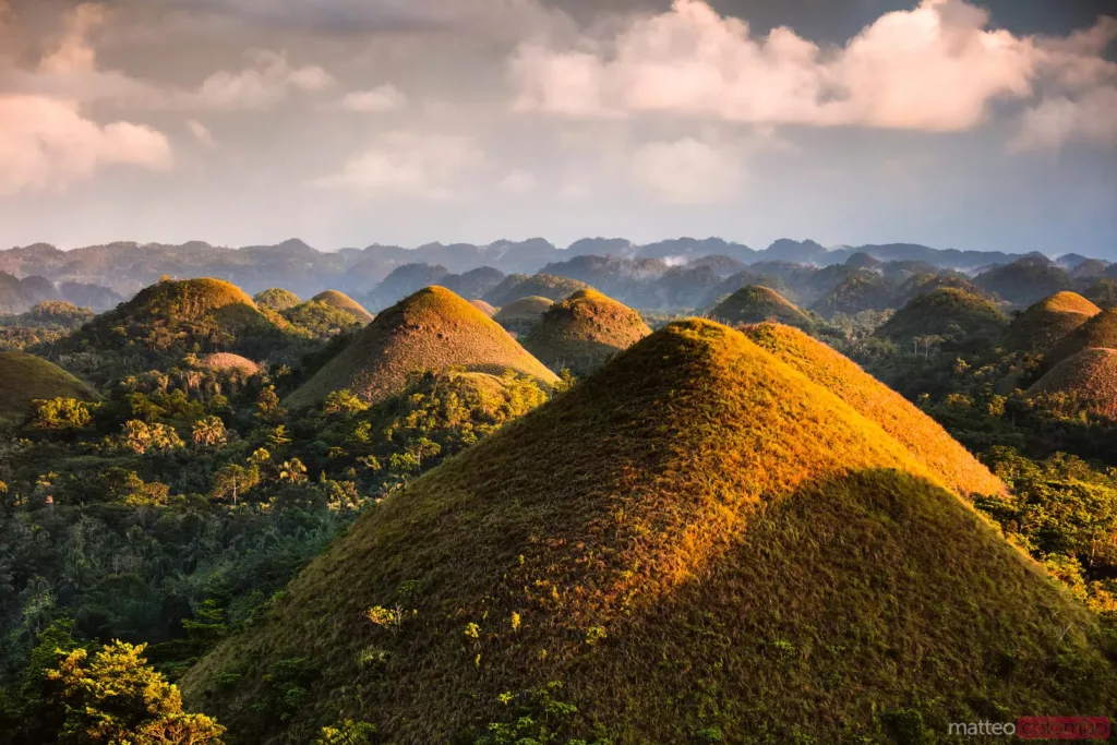
The Chocolate Hills consist of at least 1,260 cone-shaped hills spread across an area of more than 50 square kilometers on Bohol Island. During the dry season, the grass covering the hills turns chocolate brown, giving them their name and creating a landscape of geometric mounds that appears almost artificial in regularity. Each hill rises between 30 and 120 meters high, with symmetrical, conical shapes whose regularity appears almost artificial.
Geological Formation
The origin of the Chocolate Hills is still somewhat debated, but the most accepted explanation involves marine limestone and subsequent erosion. The parent rock formed from coral reef deposits when the region was beneath the ocean during the Pliocene epoch, approximately 2-5 million years ago. These limestone layers accumulated to significant depth.
Tectonic activity raised the limestone above sea level, exposing it to weathering and erosion. The uplift may have fractured the rock along numerous joints and faults. Rainfall, naturally acidified by dissolved carbon dioxide, chemically weathered the limestone through dissolution. This process preferentially attacked the rock along joints and fractures.
Areas of more resistant limestone or those less affected by fracturing eroded more slowly, while weaker areas eroded faster. This created the conical hills separated by valleys. The relatively uniform size and spacing of the hills suggest they probably formed along a regular network of fractures related to the tectonic forces that uplifted the region.
Seasonal grass growth covers the hills. During the dry season, the grass dies and turns brown, creating the “chocolate” appearance that gives the hills their name. The remarkable uniformity of their size and shape makes them one of geology’s most visually striking landscapes.
10. White Desert – Egypt
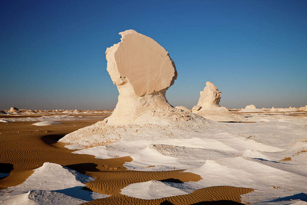
Egypt’s White Desert features surreal white chalk formations sculpted into mushroom-like shapes, animal forms and abstract structures. The pure white rock creates a dramatic contrast with the golden sand and deep blue sky, creating an environment that appears more like an alien landscape than a sculpture park. Some formations resemble chickens, sphinxes or abstract modern art pieces.
Geological Formation
The White Desert formed through a distinctive combination of marine deposition and wind erosion. During the Cretaceous Period, approximately 75 million years ago, the region was covered by a shallow tropical sea. Microscopic marine organisms with calcium carbonate shells died and accumulated on the sea floor over millions of years, forming thick layers of pure white chalk.
Later tectonic activity raised the ancient sea floor, transforming it into dry land. The chalk layers, originally horizontal, were exposed to atmospheric weathering. The primary sculptor of the White Desert is wind-driven sand. Fine sand particles carried by wind act as an abrasive, gradually wearing away the softer chalk. This process, called aeolian erosion, is most effective at ground level where wind-blown sand is most concentrated.
The distinctive mushroom shapes form because wind erosion is strongest near the ground, where sand concentration is highest. This creates the narrow “stems” of the mushrooms, while the “caps” remain protected above the zone of maximum erosion.
Small variations in chalk composition create differences in erosion resistance. Harder layers protect the softer chalk beneath them, leading to the formation of caps and overhangs. The formations continue to evolve. Wind patterns, sand supply and climate variations all affect erosion rates.
The brilliant white color results from the pure calcium carbonate composition of the chalk, which reflects nearly all visible light. The absence of iron oxides and other minerals that would add color keeps the rock pristine white.
Conclusion: Geology as Art
These ten landscapes demonstrate that geology is not just science but also art on a planetary scale. Each formation reveals fundamental geological principles: erosion, deposition, chemical weathering and tectonic forces working together to create forms of extraordinary beauty.
What makes these landscapes so compelling is the intersection of pattern and randomness. Geological processes follow physical and chemical laws that create recognizable patterns: the hexagonal columns of basalt, the spherical form of concretions, the wave-like curves of differential erosion. Yet each formation is unique, shaped by the specific combination of rock type, climate, time and geological history at that location.
These landscapes also remind us that Earth’s surface is not static but constantly evolving. For geologists, these formations are more than beautiful curiosities. They are textbooks written in stone, recording millions or billions of years of Earth history.
Understanding these rock landscapes does not diminish wonder; it enhances it. Knowing that The Wave’s perfect curves formed from ancient sand dunes or that Giant’s Causeway’s columns resulted from cooling lava deepens our appreciation for both the beauty and the time scales involved in their creation.


