


")


")
Mountains are symbols of strength and permanence — yet, in moments of geological fury, they can crumble with devastating consequences. Landslides are among the most destructive natural disasters on Earth, capable of wiping out entire towns in seconds. Triggered by earthquakes, heavy rains, volcanic eruptions, or human activity, these mass movements of rock, soil, and debris remind us of nature’s immense power.
This article explores the 10 deadliest landslides in world history, analyzing their causes, human impact, and the lessons they taught us about living safely in mountainous regions.
1. The Yungay Landslide, Peru (1970)
Date: May 31, 1970
Estimated deaths: 22,000–25,000
Cause: Earthquake-triggered avalanche of rock and ice
The Yungay disaster is the deadliest landslide ever recorded. On May 31, 1970, a magnitude 7.9 earthquake off the coast of Peru shook the Andes Mountains. Within seconds, a massive slab of ice and rock detached from the north face of Mount Huascarán, the country’s highest peak.
The avalanche descended more than 3,000 meters, accelerating to speeds of over 280 km/h (175 mph). The flow — a deadly mixture of rock, ice, and mud — swept through the valley, burying the entire town of Yungay beneath tens of meters of debris.
Eyewitnesses described a roaring white cloud engulfing the valley, followed by silence. Out of roughly 25,000 inhabitants, fewer than 400 survived. The event not only marked a national tragedy but also changed how scientists study the relationship between earthquakes and slope stability in glaciated regions.
Today, the buried town remains a national cemetery, while the nearby Huascarán National Park serves as both a memorial and a field laboratory for geologists.
2. The Haiyuan Earthquake Landslides, China (1920)
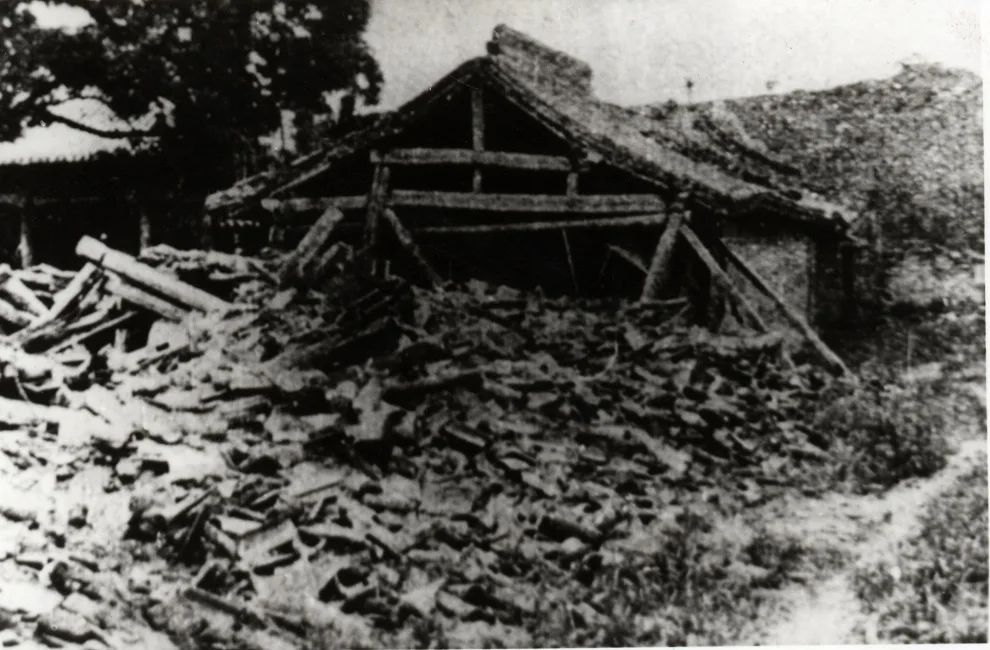
Source: Jingning County Archives
Date: December 16, 1920
Estimated deaths: ~100,000 (many from landslides)
Cause: Earthquake-induced slope failures
On December 16, 1920, the Haiyuan earthquake struck Gansu Province in north-central China with a magnitude of 8.5. The shaking was so intense that entire mountain ranges collapsed. Thousands of landslides swept through the Loess Plateau, where loose, fine-grained soils turned into deadly flows.
The quake and resulting landslides destroyed more than 100 villages. Many victims were buried under collapsing cliffs or within massive soil avalanches that dammed rivers and created temporary lakes.
Although the event is classified primarily as an earthquake, most of the casualties occurred because of landslides and ground failure, not shaking alone. The Haiyuan disaster remains a sobering example of how geological conditions can amplify the destruction caused by earthquakes.
3. The Armero Tragedy, Colombia (1985)
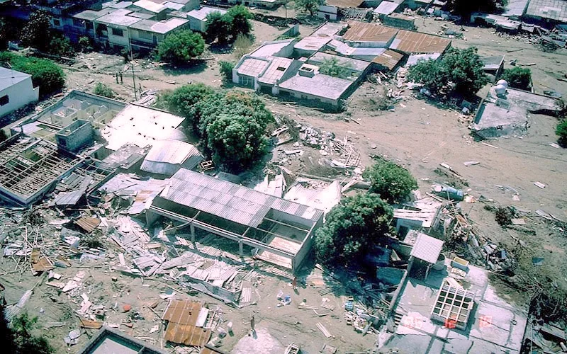
Date: November 13, 1985
Estimated deaths: 23,000
Cause: Volcanic eruption and lahars (volcanic mudflows)
The Nevado del Ruiz Volcano in Colombia had been dormant for decades before showing signs of activity in 1985. Scientists issued warnings, but few took them seriously. On November 13, the volcano erupted, melting part of its ice cap and triggering lahars — fast-moving mixtures of mud, ash, and water.
Within two hours, these flows traveled 70 kilometers downriver, reaching the town of Armero. The residents had no warning; the entire community was buried under up to 8 meters of mud.
Rescuers worked for days, but conditions were dire — thick mud, unstable debris, and a lack of equipment made survival nearly impossible. The disaster became a lesson in risk communication and preparedness. Despite accurate forecasts, insufficient evacuation planning cost thousands of lives.
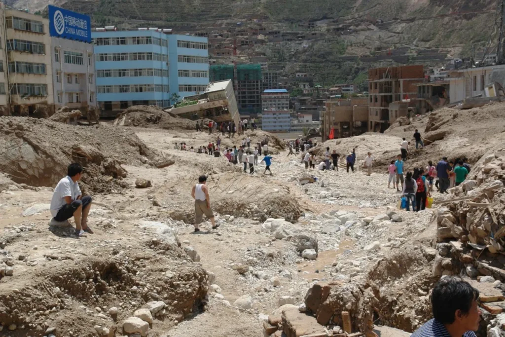
4. The Diexi Landslide, China (1933)
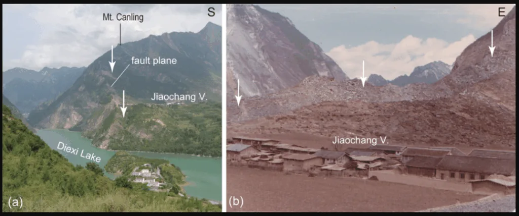
Date: August 25, 1933
Estimated deaths: 6,800
Cause: Earthquake-triggered rockslide
In August 1933, an earthquake measuring 7.5 struck Diexi County in Sichuan Province. The quake triggered a massive rockslide that buried the town of Diexi and blocked the Min River, forming Diexi Lake.
Entire villages vanished beneath the new body of water. The lake still exists today, its calm surface hiding the ruins of an ancient town. For Chinese geologists, Diexi became a landmark case for understanding seismically induced landslide dams, which can cause catastrophic flooding when they later fail.
5. The Casita Volcano Landslide, Nicaragua (1998)
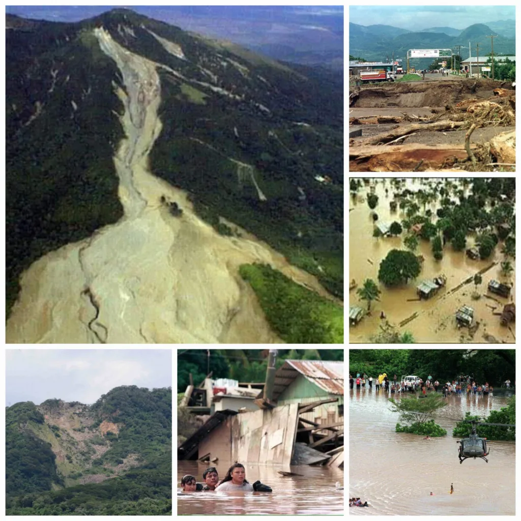
Date: October 30, 1998
Estimated deaths: 2,500
Cause: Rainfall from Hurricane Mitch triggering a volcanic slope collapse
In late October 1998, Hurricane Mitch brought unprecedented rainfall to Central America. On the slopes of Casita Volcano in Nicaragua, saturated soils and hydrothermally weakened rock gave way, creating a fast-moving debris avalanche.
The flow raced 10 kilometers downslope, burying the villages of El Porvenir and Rolando Rodríguez under thick volcanic mud. The event illustrated how extreme weather and volcanic terrain can interact to create lethal landslides.
The Casita tragedy pushed Central American countries to strengthen early warning systems and promote community-based disaster risk education.
6. The Vargas Tragedy, Venezuela (1999)
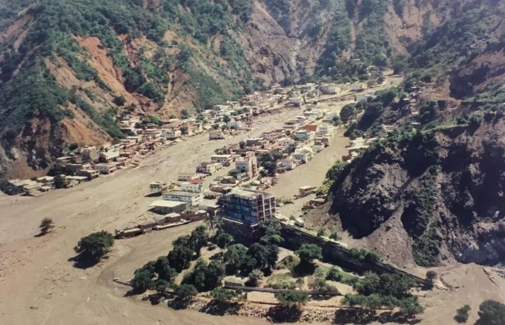
Date: December 14–16, 1999
Estimated deaths: 10,000–30,000
Cause: Torrential rain and debris flows
In December 1999, the Venezuelan state of Vargas experienced a week of relentless rainfall — nearly a year’s worth of precipitation in just a few days. Water-saturated slopes along the Caribbean coast gave way, sending torrents of mud, boulders, and debris down narrow valleys.
Entire neighborhoods were swept into the sea. Highways disappeared, and thousands were never found. Known locally as “La Tragedia de Vargas”, it remains one of the most destructive rain-induced disasters in the Americas.
The event prompted a national rethinking of urban planning, as many communities had been built directly on natural debris flow paths.
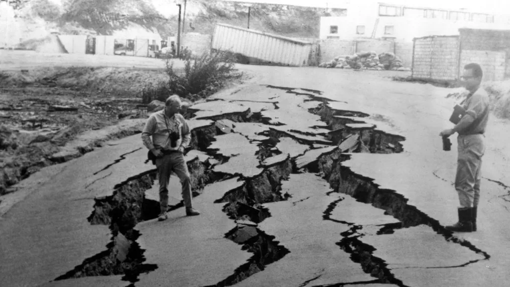
7. The Oso Landslide, United States (2014)
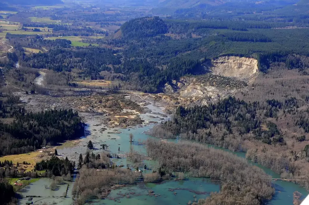
Date: March 22, 2014
Estimated deaths: 43
Cause: Rain-saturated slope collapse
The small community of Oso in Washington State, USA, was struck by tragedy when a rain-soaked hillside suddenly gave way. Within seconds, a mass of earth nearly 1 kilometer wide slid into the Stillaguamish River valley, burying homes and a highway under 20 meters of debris.
The Oso landslide surprised experts because the slope had failed before — yet the 2014 collapse traveled farther and faster than predicted. The event became one of the deadliest landslides in U.S. history and led to major advances in landslide mapping and risk modeling.
8. The Aberfan Disaster, Wales (1966)
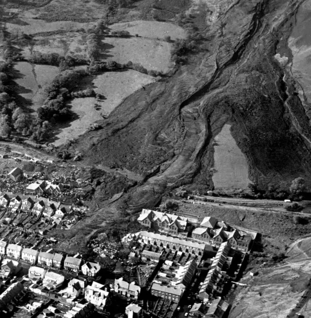
Date: October 21, 1966
Estimated deaths: 144 (including 116 children)
Cause: Collapse of a coal waste tip after heavy rain
In the mining village of Aberfan, South Wales, heavy rainfall saturated a large pile of coal waste above the town. Without warning, the heap liquefied and rushed downhill, engulfing Pantglas Junior School and several houses.
The scene was one of unimaginable heartbreak. The majority of victims were schoolchildren, caught in their classrooms as the black slurry crashed through the walls.
The Aberfan disaster was a turning point in industrial and environmental regulation, leading to new safety laws for waste storage and greater oversight of mining operations. Today, the site is a memorial garden dedicated to the victims.
9. The Zhouqu Landslides, China (2010)
Date: August 8, 2010
Estimated deaths: 1,471
Cause: Intense monsoon rainfall and debris flow
After weeks of heavy summer rainfall, slopes above Zhouqu County in Gansu Province became saturated. In the early hours of August 8, a series of massive debris flows thundered through the town, carrying mud, boulders, and trees.
Buildings were crushed, and entire streets disappeared under several meters of sediment. Rescue operations were complicated by continuing rain and blocked roads. The Zhouqu disaster highlighted how deforestation and soil erosion can worsen the impact of natural events by reducing slope stability.
10. The Kedarnath Landslides, India (2013)
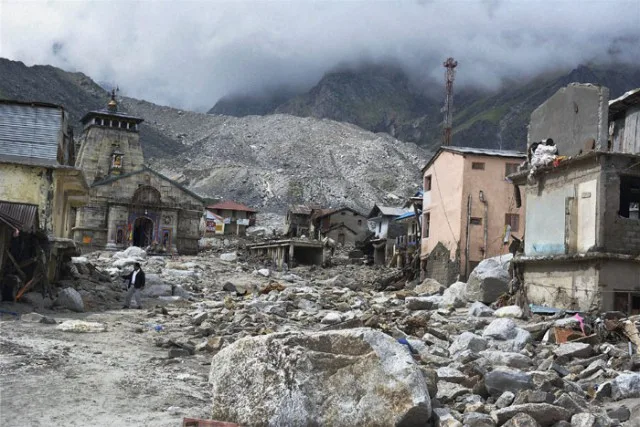
Date: June 16–17, 2013
Estimated deaths: ~5,700
Cause: Flash floods, glacial melting, and slope failure
The holy town of Kedarnath, located in India’s Uttarakhand Himalayas, attracts thousands of pilgrims each year. In June 2013, record-breaking rainfall and rapid glacial melting triggered flash floods and landslides across the region.
Water and debris cascaded through the Mandakini River valley, destroying roads, bridges, and temples. Kedarnath itself was buried under mud and rocks. The combination of climate change, deforestation, and unregulated construction amplified the disaster.
In the aftermath, India strengthened its mountain hazard monitoring systems and limited development in ecologically fragile areas.
Why Landslides Happen: Common Causes
Landslides result from a delicate balance between gravity and the strength of the materials holding a slope together. When that balance is disturbed, collapse occurs.
Main triggers include:
- Earthquakes: Vibrations loosen slopes (Yungay, Haiyuan).
- Volcanic activity: Eruptions and melting ice create lahars (Armero, Casita).
- Intense rainfall: Water saturation weakens soil (Vargas, Zhouqu).
- Glacial melting: Destabilizes slopes in high mountains.
- Human activity: Deforestation, mining, and construction accelerate erosion.
Geological Lessons and Risk Reduction
The deadliest landslides in history share common lessons for geologists and policymakers:
- Recognize hazard zones. Historical records often reveal previous landslides in the same area. Settlements should avoid these paths.
- Integrate early warning systems. Sensors measuring rainfall, ground motion, and slope deformation can save lives.
- Preserve natural vegetation. Trees and roots help bind soil and absorb water.
- Plan sustainable infrastructure. Roads, mining, and construction should respect slope stability assessments.
- Public education. Awareness campaigns can teach people to recognize warning signs like cracks, tilting trees, or unusual ground noises.
Summary Table – 10 Deadliest Landslides
| Rank | Event | Year | Country | Estimated Deaths | Main Cause |
|---|---|---|---|---|---|
| 1 | Yungay (Huascarán) | 1970 | Peru | 22,000–25,000 | Earthquake + Avalanche |
| 2 | Haiyuan | 1920 | China | ~100,000 | Earthquake |
| 3 | Armero | 1985 | Colombia | 23,000 | Volcanic mudflows |
| 4 | Diexi | 1933 | China | 6,800 | Earthquake |
| 5 | Casita Volcano | 1998 | Nicaragua | 2,500 | Hurricane rain |
| 6 | Vargas | 1999 | Venezuela | 10,000–30,000 | Heavy rainfall |
| 7 | Oso | 2014 | USA | 43 | Saturated slope |
| 8 | Aberfan | 1966 | Wales | 144 | Waste tip collapse |
| 9 | Zhouqu | 2010 | China | 1,471 | Monsoon rain |
| 10 | Kedarnath | 2013 | India | 5,700 | Flood + Slope failure |
References
- USGS (2023). Historic Deadly Landslides Database.
- UNDRR (2022). Global Risk Report on Natural Hazards.
- Evans, S.G., and Clague, J.J. (1994). Catastrophic Landslides: Geological Society of America Bulletin.
- NASA Earth Observatory. Remote Sensing Analysis of Landslide Impacts.
- National Geographic Archives. Historic Landslide Events.
- Wikipedia. List of Landslides and Mudflows by Death Toll.


