















Earthquakes
Earthquakes are sudden ground vibrations caused by the release of energy within Earth, most commonly through rapid slip along a geological fault. Seismic waves generated by rupture travel through the planet and along its surface. Their effects depend on earthquake size, focal depth, rupture geometry, local geology and the vulnerability of structures.
Earthquakes provide evidence of active tectonic processes and the mechanical behavior of rocks. They also help scientists investigate Earth’s internal structure and evaluate seismic hazards.
Earthquake Science
Earthquake Articles
Scientific explanations, active faults, seismic waves and documented earthquake case studies.

What Causes Earthquakes?
Most earthquakes are tectonic. As lithospheric plates move, stress changes within rocks and along existing faults. Friction may prevent portions of a fault from slipping even while the surrounding rock continues to deform elastically. When conditions permit unstable slip, rupture can propagate along the fault and generate seismic waves.
The elastic rebound model describes the accumulation and release of elastic strain during many tectonic earthquakes. Not all accumulated strain is released in one event, and some fault segments accommodate movement by slow, aseismic creep.
Tectonic, Volcanic and Induced Earthquakes
| Earthquake origin | Mechanism |
|---|---|
| Tectonic | Unstable slip along faults under tectonic stresses |
| Volcanic | Rock fracture, fluid movement or pressure changes within a volcanic system |
| Collapse | Failure of underground cavities, mines or other subsurface structures |
| Induced | Human activities affecting underground stresses or fluid pressures, including some injection or extraction operations |
Plate boundaries concentrate much global seismic activity, but earthquakes also occur within tectonic plates. Read Plate Tectonics and Earthquakes and Seismicity.
Hypocenter, Epicenter and Fault Rupture
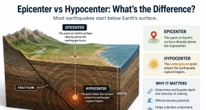
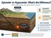
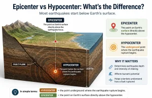
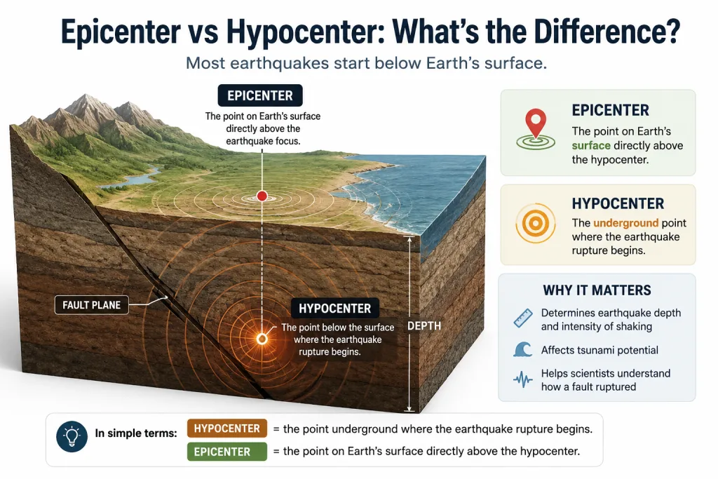
The hypocenter or focus is the estimated location where rupture begins. The epicenter is the point on Earth’s surface directly above it. A large earthquake ruptures a finite fault area, so the strongest shaking does not necessarily occur at the epicenter.
| Depth classification | Focal depth |
|---|---|
| Shallow | 0–70 km |
| Intermediate | 70–300 km |
| Deep | 300–700 km |
Intermediate and deep earthquakes occur mainly within subducting lithospheric slabs. Shallow events can produce especially strong local shaking, although magnitude, distance, direction of rupture and site conditions also matter. See Epicenter vs Hypocenter.

Types of Faults and Earthquakes
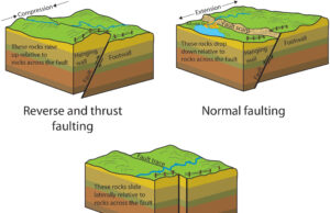
| Fault type | Relative movement | Typical tectonic setting |
|---|---|---|
| Normal | Hanging wall moves down relative to footwall | Extension; rifts |
| Reverse or thrust | Hanging wall moves up relative to footwall | Compression; collision and subduction |
| Strike-slip | Predominantly horizontal displacement | Transform boundaries and continental shear zones |
| Oblique-slip | Combination of dip-slip and strike-slip motion | Complex tectonic settings |
The largest recorded tectonic earthquakes have occurred on subduction megathrusts, where extensive fault areas can rupture. Strike-slip and normal faults can also generate highly destructive earthquakes. See Types of Faults and How They Trigger Earthquakes and Fault and Types of Faults.
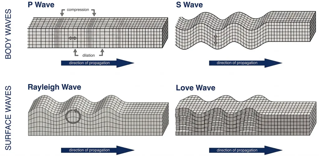
Seismic Waves: P, S, Love and Rayleigh
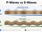
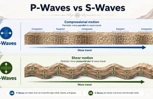
Body waves travel through Earth’s interior; surface waves propagate along or near its surface. Wave speeds and amplitudes depend on the elastic properties and density of the materials through which they travel.
| Wave | Particle motion | Propagation |
|---|---|---|
| P (primary) | Compression and expansion parallel to propagation | Solids and fluids |
| S (secondary) | Shear perpendicular to propagation | Solids |
| Love | Horizontal transverse motion | Near Earth’s surface |
| Rayleigh | Elliptical motion in a vertical plane | Near Earth’s surface |
P waves generally arrive first at a station, followed by S waves and surface waves. Differences in arrival time help constrain earthquake location. Surface waves often contribute substantially to shaking, but damage depends on the complete wavefield and the response of structures. Read Seismic Waves and P-Waves vs S-Waves.

How Earthquakes Are Measured
Magnitude and Seismic Moment
Moment magnitude (Mw) is based on seismic moment, which depends on the rigidity of the rock, the rupture area and average slip. It is widely used for comparing earthquake sizes, particularly for large events. Local magnitude (ML), associated with the original Richter scale, is useful within specific distance and magnitude ranges.
Seismic moment M₀ = μ × A × D, where μ is shear modulus, A is rupture area, and D is average slip. A one-unit increase in magnitude corresponds approximately to 32 times more radiated energy, although actual energy release varies.
Intensity and Ground Motion
Intensity describes observed shaking and its effects at a particular location, rather than the overall size of the earthquake. Modified Mercalli Intensity (MMI) uses twelve levels from I to XII. Instruments also record peak ground acceleration, peak ground velocity and response spectra, which are useful for engineering.
| Measure | Meaning |
|---|---|
| Mw | Earthquake size estimated from seismic moment |
| MMI | Observed or estimated shaking effects at a location |
| PGA | Maximum recorded ground acceleration |
| PGV | Maximum recorded ground velocity |
Related guide: Causes and Measurements of Earthquakes.

Earthquake Hazards and Secondary Effects
Ground Shaking and Site Effects
Shaking varies with rupture distance, focal depth, directivity, attenuation and local geology. Soft sediments can amplify certain frequencies and prolong shaking, while basin geometry and topography may modify the wavefield. Structural vulnerability and resonance help determine the resulting damage.
Surface Rupture and Liquefaction
Surface rupture occurs when fault displacement reaches the ground surface. It can offset roads and pipelines and damage structures located across the fault. Liquefaction may occur in susceptible loose, saturated granular soils when cyclic loading increases pore-water pressure and reduces effective stress. Consequences include settlement, lateral spreading and loss of bearing resistance.
Landslides and Tsunamis
Earthquake shaking can destabilize slopes and cause rockfalls, landslides or debris avalanches. Some large submarine earthquakes displace enough water to generate tsunamis; not every offshore earthquake produces a tsunami. See Landslides and Tsunamis.
Aftershocks, Foreshocks and Earthquake Sequences
Aftershocks occur as stresses redistribute following a larger earthquake, often near its rupture zone. Their rate generally decreases with time, but damaging aftershocks can occur. Foreshocks are identified retrospectively when a larger earthquake follows. A small earthquake cannot reliably be classified in advance as a foreshock.
Earthquake swarms are sequences without a clearly dominant mainshock and may be associated with tectonic or fluid-related processes. Earthquake sequences may last days, months or longer.
Major Historical Earthquakes
| Event | Year | Approximate Mw | Scientific significance |
|---|---|---|---|
| Valdivia, Chile | 1960 | 9.5 | Largest instrumentally recorded earthquake |
| Alaska, USA | 1964 | 9.2 | Megathrust rupture and tsunami generation |
| Sumatra–Andaman | 2004 | 9.1 | Indian Ocean tsunami |
| Tōhoku, Japan | 2011 | 9.1 | Subduction megathrust and destructive tsunami |
| İzmit, Türkiye | 1999 | 7.6 | North Anatolian Fault strike-slip rupture |
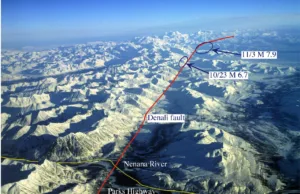
| Kahramanmaraş, Türkiye–Syria | 2023 | 7.8 and 7.5 | Major earthquake doublet and extensive surface rupture |
Magnitude estimates are rounded and may differ slightly between catalogs. Related case studies: Türkiye–Syria Earthquake 2023, Nepal Earthquake 2015, Most Powerful Earthquakes in Recorded History.
Earthquake Monitoring, Forecasting and Early Warning
Seismometer networks record ground motion and allow scientists to estimate earthquake location, origin time, magnitude and source mechanism. GNSS measures crustal displacement, while satellite interferometry (InSAR) maps surface deformation. Geological studies of active faults and past earthquakes provide longer-term evidence for hazard assessment.
No validated method can reliably predict the exact time, location and magnitude of a future major earthquake. Probabilistic seismic hazard assessment estimates expected levels of shaking over specified time intervals. Earthquake early warning is different: it detects an earthquake already in progress and may provide seconds of warning before strong shaking reaches some locations.
Seismic Risk and Engineering Geology
Seismic hazard describes the likelihood and severity of potentially damaging earthquake effects. Risk also depends on exposure and vulnerability. Engineering geologists and geotechnical engineers evaluate soil and rock profiles, groundwater conditions, potential liquefaction, slope stability and site-specific ground motion.
- Seismic-resistant structural design and retrofitting.
- Geological mapping and investigation of active faults.
- Ground investigation and assessment of site amplification or liquefaction susceptibility.
- Land-use planning, monitoring, emergency procedures and public education.
During earthquake shaking, follow official local safety guidance. In many indoor settings, the recommended action is Drop, Cover and Hold On; coastal communities should also follow tsunami evacuation guidance after strong or long shaking.
Frequently Asked Questions
What causes most earthquakes?
Sudden unstable slip along geological faults under accumulated tectonic stress.
What is the difference between epicenter and hypocenter?
The hypocenter is the rupture initiation point inside Earth. The epicenter is directly above it on the surface.
Which seismic waves arrive first?
P waves usually arrive first because they travel faster than S waves through the same solid materials.
Can scientists predict earthquakes?
Scientists estimate probabilities and monitor active faults but cannot reliably predict the exact time, location and magnitude of a future earthquake.
Do all earthquakes produce tsunamis?
No. Significant water displacement is required, and many earthquakes occur inland or do not appreciably displace the seafloor.
Why do earthquakes of the same magnitude cause different damage?
Depth, distance, rupture characteristics, local geology, exposure and structural vulnerability all affect damage.
What is the difference between magnitude and intensity?
Magnitude describes overall earthquake size; intensity describes shaking and effects at a specific location.
Scientific References and Earthquake Resources
- USGS Earthquake Hazards Program
- USGS Latest Earthquakes
- USGS — Can You Predict Earthquakes?
- NOAA Tsunami Warning System
Related section: Natural Hazards.
More Earthquake Articles