


")


The theory of plate tectonics is the unifying framework of modern geology.
It explains how the Earth’s rigid outer shell — the lithosphere — is divided into large slabs called tectonic plates, which move slowly over the semi-molten asthenosphere beneath.
This continuous motion builds mountains, opens ocean basins, triggers earthquakes, and fuels volcanic eruptions.
Before the mid-20th century, most scientists believed that Earth’s continents and oceans were fixed in place.
However, discoveries in oceanography, paleomagnetism, and seismology revealed that the planet’s surface is far more dynamic than previously imagined.
Plate tectonics combines earlier theories such as continental drift (proposed by Alfred Wegener in 1912) and seafloor spreading into a single, elegant explanation for how the surface of our planet evolves.
This revolutionary concept not only transformed geology but also linked multiple Earth systems — from the deep mantle to the atmosphere — showing that the planet is a living, changing entity.
? Structure of the Earth: The Engine of Plate Motion
To understand plate tectonics, we must first look inside the planet.
The Earth consists of three main layers:
- Crust – a thin, solid shell ranging from 5 km (oceanic crust) to 70 km (continental crust).
- Mantle – a thick layer of silicate rocks rich in magnesium and iron; extends down to 2,900 km.
- Core – composed mainly of iron and nickel, divided into a liquid outer core and a solid inner core.
The crust and the uppermost mantle together form the lithosphere, a rigid layer broken into about a dozen major plates.
Beneath it lies the asthenosphere, a partially molten zone that behaves plastically.
Heat escaping from the core and mantle drives convection currents in this zone, which in turn push and pull the overlying plates.
? The Major Tectonic Plates
Earth’s lithosphere is divided into seven major and several smaller plates that fit together like a jigsaw puzzle.
The largest plates are:
- Pacific Plate – covers most of the Pacific Ocean
- North American Plate
- South American Plate
- Eurasian Plate
- African Plate
- Indo-Australian Plate
- Antarctic Plate
Minor plates include the Nazca, Philippine, Arabian, Cocos, and Caribbean Plates.
Each moves at a rate of 2–10 cm per year, roughly the speed at which fingernails grow.
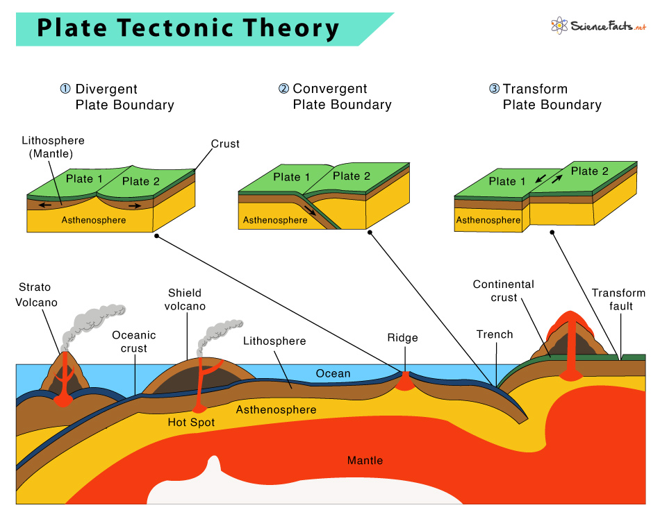
Plate Boundaries and Their Interactions

The edges where plates meet are called plate boundaries.
These regions are the most geologically active parts of the planet — home to earthquakes, volcanoes, and mountain-building.
1. Divergent Boundaries – Where Plates Move Apart
At divergent boundaries, plates pull away from each other.
Hot mantle material rises to fill the gap, cools, and solidifies to form new crust.
This process, called seafloor spreading, constantly renews the ocean floor.
Examples:
- Mid-Atlantic Ridge – separates the Eurasian and North American plates.
- East African Rift – continental crust beginning to split apart.
As magma wells up along these ridges, it records Earth’s magnetic field.
Alternating bands of magnetic polarity on either side of the ridges were key evidence confirming plate motion.
2. Convergent Boundaries – Where Plates Collide
At convergent margins, plates move toward each other.
Depending on the type of crust involved, three scenarios occur:
a. Oceanic–Continental Convergence
The denser oceanic plate subducts beneath the lighter continental plate, forming deep ocean trenches and volcanic arcs.
Example: Andes Mountains — the Nazca Plate subducting beneath South America.
b. Oceanic–Oceanic Convergence
One oceanic plate descends beneath the other, producing island arcs such as the Mariana Islands and Japan.
c. Continental–Continental Convergence
When two buoyant continental plates collide, neither subducts.
Instead, the crust thickens and crumples upward to form massive mountain ranges — for example, the Himalayas, where India continues to collide with Asia.
These regions are also prone to massive earthquakes as compressional forces accumulate and release energy.

3. Transform Boundaries – Sliding Past Each Other
At transform boundaries, plates move laterally rather than vertically.
Crust is neither created nor destroyed, but stress along these faults generates frequent earthquakes.
Example: San Andreas Fault in California — where the Pacific Plate slides northwest relative to the North American Plate.
Transform faults are also common along mid-ocean ridges, connecting offset segments of divergent boundaries.
Plate Tectonics and Volcanism
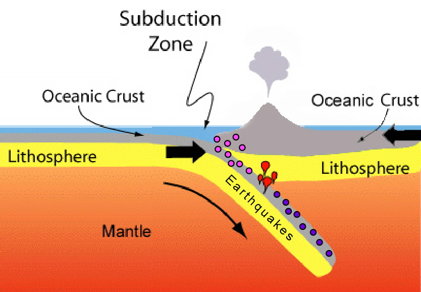
Plate tectonics and volcanism are closely related because the majority of Earth’s volcanic activity occurs at plate boundaries. Magma rises from the mantle and is forced upward by tectonic plate movement, creating volcanic eruptions. The type of volcano and eruption style is determined by the composition and viscosity of the magma.
At divergent plate boundaries, magma rises from the mantle to create new crust, forming shield volcanoes that are typically non-explosive. Mid-ocean ridges are examples of this type of volcanic activity.
At convergent plate boundaries, the denser oceanic plate subducts beneath the less dense continental plate, melting the subducted plate to form magma. This type of volcanic activity can result in explosive eruptions and the formation of stratovolcanoes. The Pacific Ring of Fire is a zone of intense volcanic activity that occurs at convergent plate boundaries.
Transform plate boundaries do not typically produce volcanic activity, but they can create volcanic features such as fissure eruptions and volcanic vents.
In summary, plate tectonics plays a significant role in the formation and location of volcanoes, and the type of volcanic activity is determined by the plate boundary type and magma composition.
Plate Tectonics and Mountain Building
Plate tectonics plays a significant role in mountain building or orogeny. Mountains are formed by the deformation and uplift of the Earth’s crust. There are two types of mountain-building processes: 1) convergent boundary mountain building and 2) intraplate mountain building.
- Convergent boundary mountain building occurs where two tectonic plates collide and cause uplift and deformation. The most prominent example of this type of mountain building is the Himalayan mountain range. The Indian subcontinent collided with the Eurasian plate, causing the uplift of the Himalayas.
- Intraplate mountain building occurs where a tectonic plate moves over a mantle plume. As the plate moves over the plume, magma rises to the surface, creating volcanic islands and a chain of mountains. The Hawaiian Islands are an example of intraplate mountain building.
Plate tectonics also plays a role in the formation of other geological structures, such as rift valleys and oceanic trenches. In rift valleys, the crust is pulled apart by tectonic forces, causing the formation of a valley. Oceanic trenches form at subduction zones, where one tectonic plate is pushed under another and into the mantle. As the plate descends, it bends and forms a deep trench.
Plate Tectonics and the Rock Cycle
Plate tectonics and the rock cycle are closely related processes that shape the Earth’s surface and the composition of its crust. The rock cycle describes the transformation of rocks from one type to another through geologic processes such as weathering, erosion, heat and pressure, and melting and solidification. Plate tectonics plays a significant role in the rock cycle by recycling and changing the Earth’s crust through subduction, collision, and rifting processes.
Subduction zones are areas where one tectonic plate is being forced beneath another, and they are associated with the formation of volcanic arcs and island arcs. As the subducting plate descends into the mantle, it heats up and releases water, which lowers the melting temperature of surrounding rocks and generates magma. This magma rises to the surface and forms volcanoes, which release new minerals and gases into the atmosphere.
Collision zones occur where two tectonic plates converge and uplifts the crust, leading to the formation of mountain ranges. The collision of the Indian and Eurasian plates, for example, created the Himalayan mountain range. This process also causes metamorphism of rocks, as the intense heat and pressure of the collision transforms them into new types of rocks.
Rifting zones are areas where tectonic plates are moving apart, leading to the formation of new ocean basins and mid-ocean ridges. As plates move apart, the crust is thinned, and magma rises to fill the gap, eventually solidifying and forming new crust. This process produces volcanic activity and can lead to the formation of new mineral deposits.
In summary, plate tectonics drives the rock cycle by creating new crust, recycling old crust, and transforming rocks through subduction, collision, and rifting processes.
Plate Tectonics and the Evolution of Life
Plate tectonics have played a significant role in the evolution of life on Earth. It has shaped the planet’s environment and allowed for the development and diversification of life over time. Here are some ways that plate tectonics has influenced the evolution of life:
- Formation of continents: Plate tectonics has caused the formation of continents and their movement over time. The separation and collision of continents have created diverse habitats for different types of organisms to evolve.
- Climate change: Plate tectonics has influenced climate change by changing the distribution of land and sea and the circulation patterns of the oceans and atmosphere. This has affected the evolution of species by creating new habitats and changing environmental conditions.
- Biogeography: The movement of continents has created barriers and pathways for the migration of species, leading to the development of unique ecosystems and biogeographic patterns.
- Volcanism: Plate tectonics has led to the formation of volcanoes, which have contributed to the evolution of life by providing new habitats and nutrient-rich soil.
Overall, plate tectonics has been a key factor in shaping the Earth’s environment and creating the conditions necessary for the evolution and diversification of life.
Plate Tectonics and Mineral Resources
Plate tectonics plays a significant role in the formation and distribution of mineral resources. Ore deposits, including precious metals such as gold, silver, and platinum, as well as industrial metals such as copper, zinc, and lead, are often associated with tectonic plate boundaries.
At convergent plate boundaries, subduction zones can generate large-scale mineral deposits, including porphyry copper, epithermal gold, and silver, and massive sulfide deposits. These deposits are formed by hydrothermal fluids that are released from the subducting slab and the overlying mantle wedge, causing mineral precipitation in the surrounding rocks.
In addition, mid-ocean ridges, where new oceanic crust is created, can host deposits of sulfide minerals that are rich in copper, zinc, and other metals. These deposits are formed by hydrothermal vents that release mineral-rich fluids into the surrounding seawater.
Plate tectonics also influences the formation of hydrocarbon deposits, such as oil and gas. These deposits are often found in sedimentary basins that are associated with rift valleys, passive margins, and convergent margins. Organic-rich sedimentary rocks are buried and heated over time, leading to the formation of hydrocarbons.
Overall, plate tectonics is a crucial factor in the formation and distribution of mineral resources, and understanding the geological processes associated with plate boundaries is essential for identifying and exploiting these resources.
ts note that many geologic processes that others attribute to the behaviour of mantle plumes may be explained by other forces.
Hotspots and Mantle Plumes
Not all volcanic activity occurs at plate boundaries.
Some arises from hotspots — regions where plumes of hot mantle material rise from deep within the Earth.
As a tectonic plate drifts over a stationary hotspot, a chain of volcanoes forms, with the youngest volcano located directly above the plume.
Examples:
- Hawaiian Islands – formed as the Pacific Plate moved northwest over a fixed hotspot.
- Yellowstone (USA) – a continental hotspot producing geothermal activity and past super-eruptions.
By studying hotspot tracks, scientists can calculate both the direction and velocity of plate motion.
? What Drives Plate Tectonics?
The motion of tectonic plates results from several interacting forces powered by Earth’s internal heat.
- Mantle Convection – heat from the core causes slow churning currents in the mantle.
Rising hot material spreads beneath the lithosphere; cooler, denser material sinks. - Ridge Push – newly formed crust at mid-ocean ridges is elevated compared to older seafloor, causing gravity-driven sliding away from the ridge.
- Slab Pull – the sinking of cold, dense oceanic lithosphere at subduction zones pulls the rest of the plate along.
- Trench Suction & Frictional Forces – local variations in density, friction, and viscosity also affect motion.
These mechanisms work together in a complex, self-regulating system that recycles the planet’s crust over hundreds of millions of years.
? Geological Evidence Supporting Plate Tectonics
The plate tectonic theory is supported by a wide range of observations:
- Magnetic Anomalies: Symmetrical stripes of normal and reversed magnetization on either side of mid-ocean ridges confirm seafloor spreading.
- Fossil Correlations: Identical fossil species found on now-separated continents (e.g., Mesosaurus in Africa and South America).
- Rock Ages: Oceanic crust is youngest near ridges and oldest near subduction zones.
- GPS Measurements: Satellite data show continents moving a few centimeters per year.
- Earthquake Distribution: Most earthquakes occur along plate boundaries, matching predicted motion patterns.
Together, these data make plate tectonics one of the most thoroughly tested theories in Earth science.
? Consequences of Plate Motion
Plate tectonics continuously reshapes Earth’s surface.
Some of its most significant geological and environmental impacts include:
- Mountain Building: The Himalayas, Andes, and Alps formed through plate collision.
- Earthquakes: Sudden release of stress along plate boundaries causes seismic events.
- Volcanoes: Subduction zones and hotspots generate intense volcanic activity.
- Ocean Basin Evolution: Divergence creates new oceanic crust, while convergence destroys old seafloor.
- Continental Drift: Continents migrate, altering global climate and biodiversity patterns.
The constant cycle of creation and destruction ensures that no part of Earth’s crust is older than about 200 million years, even though the planet itself is 4.5 billion years old.
? Plate Tectonics and Earth’s Climate
Plate motion also influences climate over geological timescales.
When continents drift toward the poles, ice sheets expand, reflecting sunlight and cooling the planet.
When landmasses cluster near the equator, chemical weathering and volcanic CO₂ release alter atmospheric composition.
Mountain building increases silicate weathering, which removes CO₂ from the air — one reason why tectonics plays a key role in long-term climate regulation.
? The Future of Plate Movements
Tectonic processes are ongoing.
GPS measurements show:
- The Atlantic Ocean continues to widen.
- The Pacific Ocean is gradually shrinking.
- The Red Sea Rift is forming a new ocean basin.
In about 250 million years, continents may merge again into a new supercontinent scientists call Pangaea Ultima or Amasia.
Earth’s surface will look dramatically different — yet driven by the same deep processes at work today.
? Conclusion
The theory of plate tectonics is not just a cornerstone of geology — it’s the grand narrative of our planet’s history.
Every earthquake, volcano, and mountain range traces its origin back to the movement of tectonic plates powered by Earth’s internal heat.
These motions are governed by mantle convection, gravity-driven slab pull, and ridge push, forces that recycle the crust, create new ocean floors, and destroy old ones.
By studying plate tectonics, scientists can interpret ancient supercontinents, predict earthquake hazards, and understand the deep connections between Earth’s geology and its biosphere.
Far from being static, our planet is a dynamic, living system, constantly reshaping itself.
The continents we know today are just snapshots in an endless cycle of creation, collision, and renewal — a geological symphony that has played for billions of years and will continue long after us.
Reference Lists
- Condie, K. C. (2019). Plate tectonics: a very short introduction. Oxford University Press.
- Cox, A., & Hart, R. B. (1986). Plate tectonics: How it works. Blackwell Scientific Publications.
- Oreskes, N. (2003). Plate tectonics: an insider’s history of the modern theory of the Earth. Westview Press.
- Stern, R. J., & Moucha, R. (2019). Plate tectonics and the history of the Earth. John Wiley & Sons.
- Torsvik, T. H., & Cocks, L. R. M. (2017). Earth history and plate tectonics: an introduction to historical geology. Cambridge University Press.
- Van der Pluijm, B. A., & Marshak, S. (2018). Earth structure: an introduction to structural geology and tectonics. WW Norton & Company.
- Wicander, R., & Monroe, J. S. (2019). Historical geology. Cengage Learning.
- Winchester, J. A., & Floyd, P. A. (2005). Geochemistry of continental potassic magmatism. Geological Society of America.
- Ziegler, P. A. (1990). Geological atlas of Western and Central Europe. Shell Internationale Petroleum Maatschappij BV.


")
