


")


The seismic method is a crucial technique in geophysics that plays a significant role in understanding the subsurface structure of the Earth. It is widely employed in various fields such as oil and gas exploration, environmental studies, civil engineering, and geological research. Seismic methods involve the use of artificially generated seismic waves and their interaction with subsurface materials to create detailed images of the Earth’s interior.
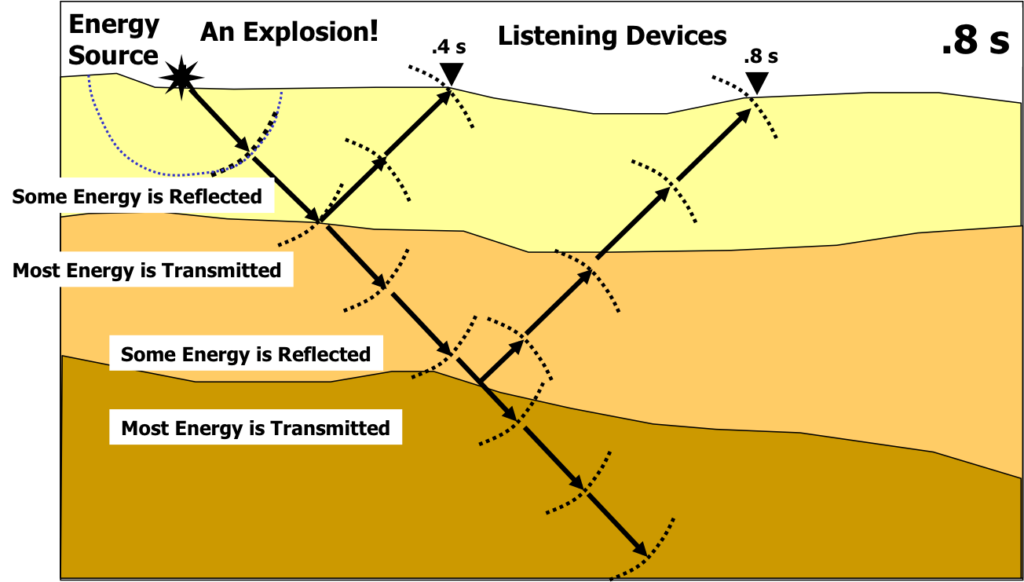
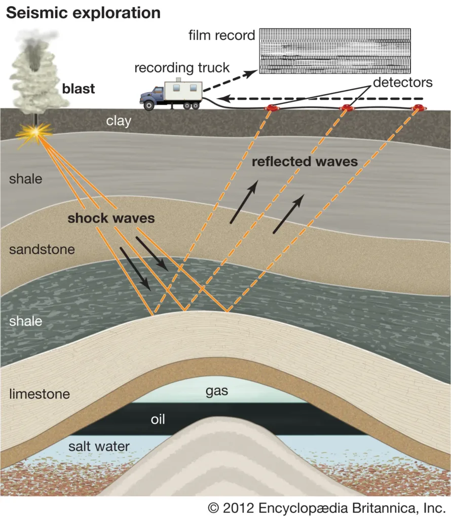
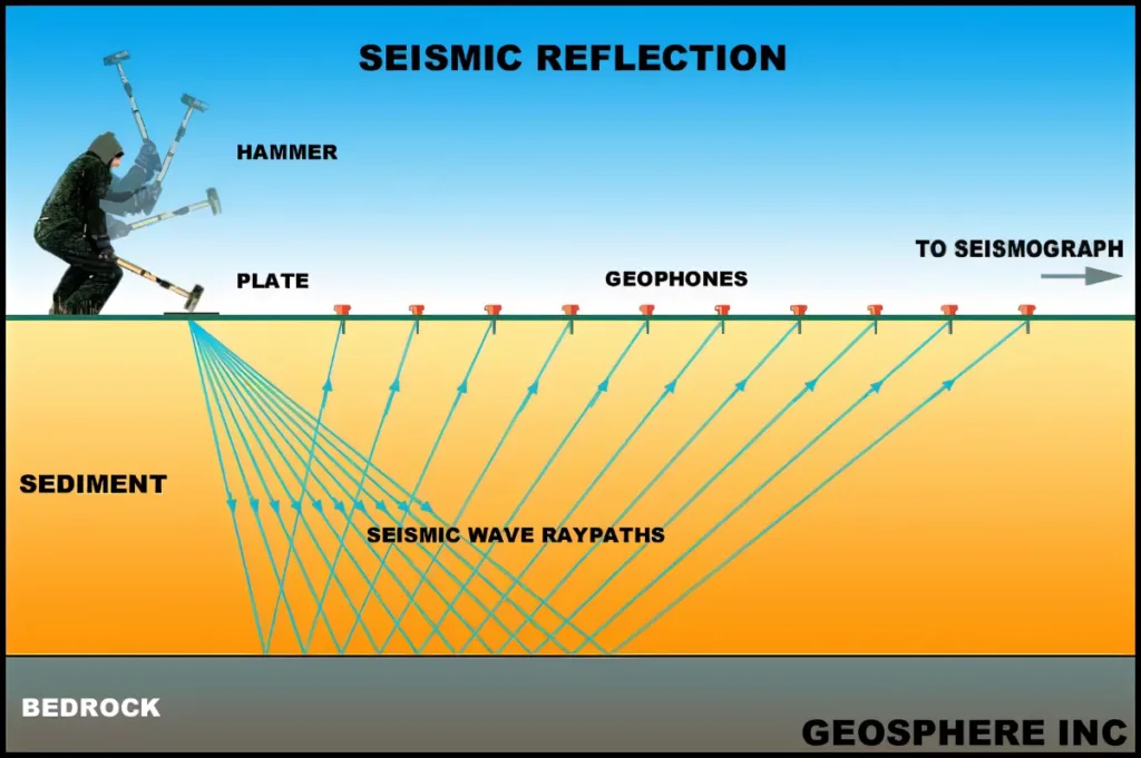
The seismic method is a geophysical technique that utilizes the propagation of seismic waves through the Earth to gather information about its subsurface structure. Seismic waves can be artificially generated by various means, including striking the ground with a heavy weight, detonating explosives, or using specialized vibrational sources. These waves travel through the Earth and are recorded by sensors (geophones or accelerometers) at the surface or in boreholes.
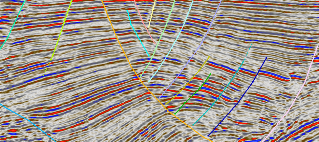
The recorded data is then processed and analyzed to create seismic images, providing valuable insights into the composition, density, and geometry of subsurface layers. The seismic method is based on the principle that seismic waves travel at different velocities through different types of rocks and geological formations.
Importance in Geophysics and Exploration:
- Subsurface Imaging: Seismic methods are essential for creating detailed images of the subsurface, helping geophysicists and geologists understand the distribution of rocks, sediments, and other geological features. This information is crucial for a wide range of applications, including resource exploration and environmental assessments.
- Hydrocarbon Exploration: In the oil and gas industry, seismic surveys are fundamental for locating potential hydrocarbon reservoirs beneath the Earth’s surface. By analyzing the reflected seismic waves, exploration teams can identify structures that may contain oil and gas deposits.
- Civil Engineering: Seismic methods are employed in civil engineering to assess the geological conditions of a site before construction. This helps engineers understand potential risks related to earthquakes and design structures that can withstand seismic forces.
- Environmental Studies: Seismic techniques are used in environmental studies to investigate subsurface conditions, including groundwater aquifers, soil properties, and potential contamination. This information is critical for environmental impact assessments and remediation projects.
- Natural Hazard Assessment: Seismic methods are vital for studying and monitoring natural hazards such as earthquakes and volcanic activity. Understanding the subsurface structure and fault lines helps in assessing seismic risks and implementing measures to mitigate potential disasters.
In summary, the seismic method is a versatile and powerful tool in geophysics and exploration, providing valuable information about the Earth’s subsurface for a wide range of applications across various industries.
Basic Principles of Seismic Method
The seismic method relies on the principles of seismic wave propagation through the Earth’s subsurface. These waves are generated artificially and then recorded to create images of the subsurface structure. The basic principles of the seismic method include:
- Generation of Seismic Waves: Seismic waves are typically generated by a controlled source, which could be a weight dropped on the ground, explosives, or a specialized vibrational device. The goal is to create a disturbance that produces waves capable of penetrating the Earth.
- Propagation of Seismic Waves: Once generated, seismic waves travel through the Earth, penetrating different layers and reflecting back to the surface at interfaces where there are changes in subsurface properties, such as rock types or geological structures. The two main types of seismic waves are compressional waves (P-waves) and shear waves (S-waves), each with distinct properties and velocities.
- Recording Seismic Waves: Seismic waves are recorded by sensors known as geophones or accelerometers, which are strategically placed on the Earth’s surface or in boreholes. These sensors detect ground motion caused by the seismic waves passing through the subsurface.
- Travel Time Analysis: The recorded data, known as seismic traces, are analyzed to determine the arrival times of seismic waves at different receivers. By measuring the travel times and understanding the velocity of the waves, geophysicists can infer the depth and properties of subsurface structures.
- Velocity Variation and Layering: Seismic waves travel at different velocities through different materials. This variation in velocity is used to distinguish between various subsurface layers and geological formations. The analysis considers both the vertical and lateral distribution of materials.
- Reflection and Refraction: Reflections occur when seismic waves encounter a boundary between two layers with different acoustic properties. Refractions occur when waves change direction due to variations in subsurface velocity. Both reflection and refraction data are crucial for constructing detailed images of the subsurface.
- Data Processing and Imaging: Seismic data undergoes extensive processing to enhance signal quality, remove noise, and convert it into a meaningful representation of the subsurface. Advanced imaging techniques, such as seismic tomography and migration, are employed to create detailed three-dimensional models.
- Interpretation: Geoscientists interpret the processed seismic images to identify geological structures, such as faults, folds, and stratigraphic layers. This interpretation provides valuable information for applications like resource exploration, environmental studies, and geological mapping.
By applying these basic principles, the seismic method allows geophysicists and geologists to gain insights into the Earth’s subsurface, enabling a better understanding of geological features and supporting various scientific and industrial applications.
Seismic Instruments and Equipment
Seismic surveys rely on specialized instruments and equipment to generate seismic waves, record the resulting data, and analyze the subsurface structure. Here are key seismic instruments and equipment used in the seismic method:
- Seismic Sources:
- Explosive Charges: Controlled explosions, often using dynamite or other explosives, are used to generate powerful seismic waves.
- Vibrators: Specialized trucks equipped with vibrational devices generate seismic waves by vibrating the ground. These are commonly used in urban areas or environmentally sensitive locations.
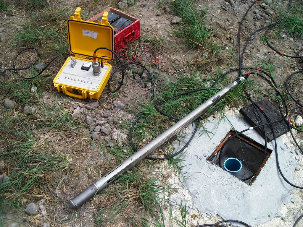
- Geophones:
- Geophones are sensors placed on the ground surface or in boreholes to detect ground motion caused by seismic waves.
- They convert ground vibrations into electrical signals, which are recorded for further analysis.
- Geophones come in various designs, including vertical and horizontal components, depending on the type of seismic waves being measured.
- Accelerometers:
- Similar to geophones, accelerometers measure ground acceleration during seismic events.
- They are often used in structural monitoring and can be more sensitive than traditional geophones.
- Seismic Cables (Spread):
- Seismic sensors are connected by cables to a central recording unit.
- The layout of these sensors, known as the spread, determines the geometry of the seismic survey and influences the quality of the data.
- Recording Systems:
- Seismic Recorders: These electronic devices record the signals from geophones or accelerometers.
- Data Acquisition Systems: These systems collect and store the recorded data for later processing.
- Modern recording systems use digital technology, allowing for more efficient data handling and storage.
- Energy Sources (Air Guns for Marine Surveys):
- In marine seismic surveys, air guns are often used as the energy source.
- These devices release compressed air into the water, creating underwater acoustic waves that penetrate the seafloor and provide information about subsurface structures beneath the ocean floor.
- Navigation Systems:
- Accurate positioning is crucial for seismic surveys, especially in marine environments.
- GPS (Global Positioning System) and inertial navigation systems help ensure precise location data for each recorded seismic trace.
- Seismic Processing Software:
- Specialized software is used to process and analyze seismic data.
- Processing steps include filtering, stacking, migration, and inversion to enhance the quality and interpretability of seismic images.
- Seismic Interpolation Tools:
- In some cases, interpolation tools are used to fill in the gaps between seismic lines, creating a more comprehensive image of the subsurface.
- Drilling Equipment (for Borehole Seismology):
- In borehole seismology, equipment such as drilling rigs and casing materials are used to create boreholes for the placement of geophones or accelerometers at depth.
These instruments and equipment work together to collect and process seismic data, providing valuable insights into the subsurface structure for applications ranging from oil and gas exploration to environmental studies and geological research.
Seismic Data Acquisition
Seismic data acquisition is a critical step in the seismic method, involving the collection of measurements from seismic sensors to create a detailed image of the Earth’s subsurface. The process typically includes the following key steps:
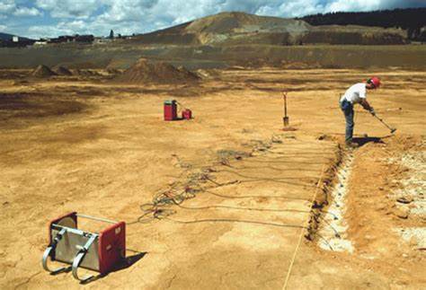
- Survey Design:
- Before acquiring seismic data, geophysicists design a survey plan to determine the layout of seismic sources and receivers.
- Factors such as the desired resolution, depth of investigation, and the nature of the subsurface influence the survey design.
- Deployment of Seismic Sources:
- Seismic sources, whether explosive charges or vibrational devices, are deployed according to the survey design.
- Explosive charges are strategically placed on the ground or within boreholes, while vibrators are mounted on specialized trucks.
- Spread Configuration:
- Geophones or accelerometers are placed in a predetermined pattern, known as the spread.
- The spread configuration influences the geometry of the survey and affects the quality of the acquired data.
- Recording Setup:
- Seismic sensors (geophones or accelerometers) are connected to recording units via cables. The recording units may be distributed across the survey area.
- The recording setup is designed to capture the arrival times and amplitudes of seismic waves at each sensor location.
- Data Acquisition:
- Seismic data acquisition involves activating the seismic sources to generate waves that propagate through the subsurface.
- The sensors detect the ground motion caused by the seismic waves, and the resulting signals are converted into electrical data.
- Timing and Synchronization:
- Precise timing and synchronization are crucial for accurate data interpretation.
- A master clock is used to ensure that seismic sources and sensors are triggered simultaneously, allowing for accurate measurement of wave arrival times.
- Quality Control:
- Real-time quality control measures are implemented during data acquisition to identify and address issues promptly.
- This may include checking for sensor malfunctions, cable connectivity, and ensuring proper source activation.
- Navigation and Positioning:
- For land surveys, GPS systems are used to accurately position seismic sources and receivers.
- In marine surveys, additional navigation systems, such as inertial navigation, are employed to ensure precise positioning in the dynamic marine environment.
- Recording and Storage:
- Seismic recorders or data acquisition systems collect and store the recorded data for subsequent processing.
- Modern systems use digital recording, allowing for efficient storage, retrieval, and analysis of large volumes of data.
- Repeat Surveys (4D Seismic):
- In some applications, such as reservoir monitoring in the oil and gas industry, seismic surveys are repeated over time to observe changes in the subsurface (4D seismic). This provides insights into reservoir dynamics.
After seismic data acquisition, the recorded data undergoes extensive processing to enhance its quality and extract valuable information about the subsurface structure. Advanced imaging techniques are then applied to create detailed three-dimensional models for interpretation and analysis.
Seismic Data Processing
Seismic data processing is a crucial step in the seismic method that involves the application of various techniques to enhance the quality, accuracy, and interpretability of the recorded seismic data. The goal is to create detailed images of the subsurface structure for geological interpretation and exploration. The seismic data processing workflow typically includes the following key steps:
- Field Data Quality Control:
- The first step involves checking the quality of the data collected during the seismic survey.
- Quality control measures address issues such as sensor malfunctions, cable problems, and any other anomalies that may affect data accuracy.
- Data Preprocessing:
- Timing Corrections: Adjustments are made to correct for variations in timing, ensuring that seismic events are accurately synchronized.
- Gain Correction: The recorded seismic traces may undergo gain corrections to account for variations in source-receiver distances and sensor sensitivities.
- Filtering:
- Various filters are applied to the seismic data to remove unwanted noise and enhance the signal of interest.
- Common filters include bandpass filters to isolate specific frequency ranges and eliminate noise.
- Deconvolution:
- Deconvolution is a process that aims to sharpen seismic wavelets and improve resolution.
- It is particularly useful in removing the effects of the seismic source from the recorded data.
- Velocity Analysis:
- Velocity analysis is performed to estimate the subsurface velocity profile.
- Different velocities of seismic waves through different subsurface materials can affect the recorded seismic data.
- Normal Moveout (NMO) Correction:
- NMO correction is applied to correct for the curvature of seismic events caused by variations in subsurface velocities.
- This correction helps to align events in the seismic data and produce a more accurate representation of subsurface structures.
- Stacking:
- Stacking involves combining multiple seismic traces to improve signal-to-noise ratio.
- It enhances the overall quality of the seismic data and increases the reliability of subsurface imaging.
- Migration:
- Migration is a critical step that corrects for the distortions in the position of subsurface reflections caused by the complex geometry of the Earth’s subsurface.
- Common migration techniques include time migration and depth migration.
- Post-Stack Processing:
- Additional processing steps may be applied after stacking to further enhance the seismic data.
- These steps may include amplitude corrections, frequency balancing, and other adjustments to improve the overall quality of the seismic image.
- Inversion:
- Inversion techniques are employed to transform seismic data into quantitative subsurface properties, such as acoustic impedance.
- This step provides more detailed information about the subsurface composition and facilitates geological interpretation.
- Interpretation:
- Geoscientists interpret the processed seismic data to identify geological features, including faults, stratigraphic layers, and potential hydrocarbon reservoirs.
Seismic data processing is a complex and iterative process that requires expertise in signal processing and geophysics. Advanced algorithms and computational methods are used to handle large volumes of data and produce accurate and high-resolution images of the Earth’s subsurface. The processed data serves as a valuable tool for decision-making in various industries, including oil and gas exploration, environmental studies, and geotechnical investigations.
Applications of Seismic Method
The seismic method finds diverse applications across various scientific, industrial, and environmental fields. Some of the key applications include:
- Oil and Gas Exploration:
- Seismic surveys are extensively used in the oil and gas industry to locate potential hydrocarbon reservoirs beneath the Earth’s surface.
- The method helps identify subsurface structures, map geological formations, and estimate the size and characteristics of potential reservoirs.
- Mineral Exploration:
- Seismic methods are employed in mineral exploration to characterize the subsurface and identify potential ore bodies.
- The technique helps in mapping geological structures, determining rock types, and assessing the composition of the Earth’s crust.
- Environmental and Engineering Studies:
- Seismic surveys are used for environmental and engineering applications, including assessing subsurface conditions for construction projects.
- The method helps evaluate soil properties, identify potential geological hazards, and assess groundwater resources.
- Civil Engineering and Infrastructure Development:
- Seismic studies are crucial in civil engineering for evaluating the geological conditions of a site before construction.
- The method helps assess the seismic risk of an area, design structures that can withstand earthquakes, and plan infrastructure projects.
- Geothermal Resource Exploration:
- Seismic methods are employed in the exploration of geothermal resources to identify subsurface structures and assess the potential for geothermal energy extraction.
- Groundwater Exploration:
- Seismic surveys are used to investigate subsurface conditions and locate potential groundwater aquifers.
- Understanding the geological formations helps in sustainable groundwater management and resource planning.
- Natural Hazard Assessment:
- Seismic methods play a crucial role in assessing and monitoring natural hazards such as earthquakes, landslides, and volcanic activity.
- The information gathered helps in understanding the subsurface dynamics and potential risks associated with these hazards.
- Carbon Capture and Storage (CCS):
- Seismic surveys are used in CCS projects to monitor the injection and storage of carbon dioxide in underground reservoirs.
- The method helps ensure the integrity of storage sites and assess the potential for leakage.
- Archaeological and Cultural Heritage Studies:
- Seismic methods are applied in archaeological studies to non-invasively explore subsurface structures and detect buried archaeological features.
- This can aid in the preservation and documentation of cultural heritage sites.
- Reservoir Monitoring (4D Seismic):
- In the oil and gas industry, repeated seismic surveys (4D seismic) are conducted to monitor changes in reservoir properties over time.
- This helps optimize production strategies, assess reservoir performance, and identify potential production issues.
- Tectonic and Earthquake Research:
- Seismic studies contribute to understanding the Earth’s tectonic processes, fault systems, and earthquake mechanisms.
- This information is vital for seismic hazard assessments and earthquake preparedness.
The seismic method’s versatility makes it a valuable tool in various disciplines, providing essential insights into the Earth’s subsurface for scientific research, resource exploration, and environmental management.
 Methods")
")


