














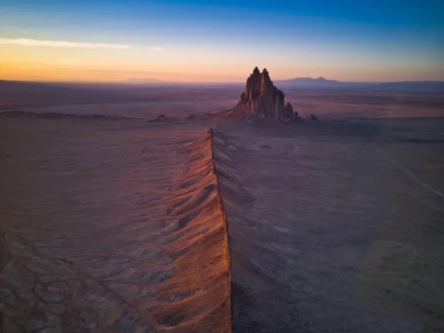
Across the broad, nearly flat desert landscape of northwestern New Mexico, a dark and jagged mass of rock suddenly rises above the horizon.
This is Shiprock.
At first glance, it looks like an enormous isolated mountain standing alone in the desert. But the most interesting part of Shiprock is not simply the rock we can see today.
It is what is no longer there.
Around 30 million years ago, this area experienced intense volcanic activity. The original volcanic landform that once existed above Shiprock has largely disappeared.
Millions of years of erosion removed the softer surrounding rocks and much of the upper volcanic structure. What remained was a more resistant part of the volcanic system that originally formed deep beneath the surface.
For this reason, looking at Shiprock is not like looking at the outside of a normal volcano.
In a sense, we are looking inside an ancient volcanic system.
The central rock mass, together with the long wall-like igneous dikes extending outward across the desert, preserves an extraordinary record of how magma moved underground millions of years ago.
So what exactly is Shiprock? How did it form? Why does it rise so dramatically above the surrounding landscape? And what are the long stone walls radiating away from the central formation?
The answer is a geological story involving explosive volcanism, magma intrusion, deep erosion, and tens of millions of years of landscape evolution.
What Is Shiprock?
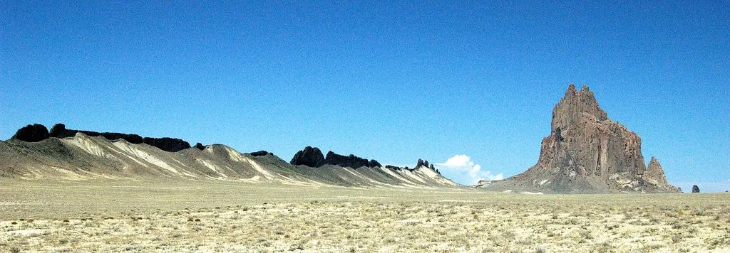
Shiprock is a massive volcanic landform located in northwestern New Mexico, United States, within the Navajo Nation.
In the Diné language, it is known as Tsé Bitʼaʼí, commonly translated as “rock with wings” or “winged rock.”
The formation rises about 480 meters, or roughly 1,580 feet, above the surrounding high-desert plain.
The main volcanic structure itself is approximately 500 meters across and represents part of a much larger volcanic system that has been heavily eroded.
Shiprock is commonly described as a volcanic neck, meaning that it represents part of the central feeder system of an ancient volcano.
However, calling it simply a solid plug of frozen lava does not fully describe its geology.
The central structure contains large amounts of fractured volcanic rock and country rock forming tuff breccia, while numerous thin intrusions of an unusual igneous rock called minette cut through the formation.
This complex structure reveals a much more violent and complicated volcanic history.
How Old Is Shiprock?
The volcanic activity responsible for Shiprock occurred roughly 30 million years ago, during the Oligocene Epoch.
Shiprock belongs to a much larger group of ancient volcanic features known as the Navajo Volcanic Field.
This volcanic field extends across parts of northwestern New Mexico and northeastern Arizona and contains numerous volcanic necks, dikes, diatremes, plugs, and unusual igneous rocks.
Today, many of these volcanic systems look very different from the landscapes that originally existed.
Erosion has removed much of the material that once covered them.
As a result, structures that originally formed hundreds of meters underground are now exposed at the surface.
Shiprock is one of the most spectacular examples.
How Did Shiprock Form?
The story of Shiprock begins with magma rising through the Earth’s crust.
Around 30 million years ago, magma moved upward through fractures and zones of weakness beneath what is now northwestern New Mexico.
As magma approached the surface, it disrupted the surrounding sedimentary rocks.
Rock around the volcanic conduit was fractured, broken apart, and incorporated into the developing volcanic system.
Explosive activity contributed to the formation of a central volcanic throat filled with large quantities of fragmented material.
This material eventually became part of the breccia visible at Shiprock today.
One geological interpretation also suggests that rising magma may have interacted explosively with groundwater.
When very hot magma encounters underground water, the water can heat rapidly and expand into steam.
Because steam occupies far more volume than liquid water, pressure can increase dramatically.
This process can cause powerful underground explosions that fracture surrounding rocks.
Such magma-water interactions can help produce a type of volcanic conduit known as a diatreme.
However, Shiprock should not be explained only as the result of magma interacting with groundwater.
Its formation involved several processes, including magma intrusion, fracturing of surrounding rocks, brecciation, dike propagation, erosion of wall rock inside conduits, and repeated movement of magma through the system.
Is Shiprock a Diatreme?
Shiprock is most commonly described as a volcanic neck or volcanic throat.
However, some geologists also interpret the structure as part of a diatreme system.
A diatreme is a steep volcanic conduit filled with broken rock produced by explosive volcanic activity.
These structures may contain a mixture of:
- fragmented volcanic rock,
- pieces of older country rock,
- volcanic ash and tuff,
- breccia,
- and later igneous intrusions.
Shiprock contains abundant breccia and is cut by numerous minette intrusions.
For this reason, describing it simply as “a giant plug of solidified magma” is an oversimplification.
The real geological structure is much more complex.
What Is Volcanic Breccia?
One of the most important rock types at Shiprock is volcanic breccia.
Breccia is a rock composed mainly of angular fragments of older rocks held together within a finer-grained matrix.
The angular shape of the fragments is significant.
Unlike rounded pebbles that may have been transported over long distances by rivers, angular breccia fragments usually indicate that the rock was broken apart relatively close to where it accumulated.
At Shiprock, volcanic activity and magma intrusion fractured the rocks surrounding the volcanic conduit.
Fragments of these rocks became incorporated into the system.
As a result, Shiprock’s central structure is not a uniform mass of lava.
It is a complicated mixture of broken rock and volcanic material that was later cut by additional igneous intrusions.
Minette: Shiprock’s Unusual Magma
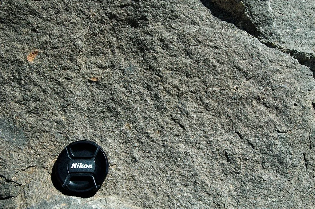
Close view of the fine-grained minette that forms parts of the igneous dikes around Shiprock.One of the most interesting parts of Shiprock’s geology is an unusual igneous rock known as minette.
Minette belongs to a group of igneous rocks known as lamprophyres.
It is particularly rich in potassium compared with many common volcanic rocks.
Minerals found in minette may include:
- phlogopite,
- clinopyroxene,
- olivine,
- feldspar,
- and other mafic minerals.
The magma that formed Shiprock had a highly potassic composition.
Geologists have suggested that this unusual magma may have formed through very small degrees of partial melting within the Earth’s mantle.
This makes Shiprock scientifically valuable for more than understanding the shape of an ancient volcano.
Its rocks may also provide clues about processes that occurred deep beneath the Colorado Plateau tens of millions of years ago.
The Rock We See Today Was Once Underground
This is one of the most surprising facts about Shiprock.
The towering rock formation visible today did not originally stand above the landscape in its present form.
Geological interpretations suggest that the rocks now exposed at Shiprock may have formed approximately 750 to 1,000 meters beneath the ancient land surface.
Imagine standing in the same location around 30 million years ago.
The Shiprock we photograph today would have been hidden underground.
Hundreds of meters of rock would have existed above it.
The original volcanic system may have included a volcanic vent, surface deposits, and other structures that have since been removed.
Today, much of that material is gone.
The process responsible for revealing Shiprock is just as important as the volcanism that created it.
That process is erosion.
How Did Erosion Expose Shiprock?
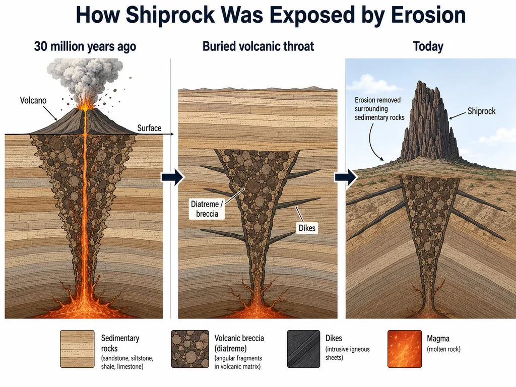
Volcanic activity eventually stopped, but geological change continued.
Rain, running water, wind, temperature changes, freeze-thaw cycles, and chemical weathering slowly attacked the landscape.
But not all rocks erode at the same rate.
Many of the sedimentary rocks surrounding Shiprock were less resistant to erosion than the hardened igneous and brecciated rocks of the volcanic system.
Over millions of years, the surrounding rocks were gradually removed.
The regional land surface became lower.
Structures that had once been deeply buried slowly became exposed.
The harder volcanic rocks of Shiprock resisted erosion more effectively than many of the surrounding sedimentary rocks.
Eventually, the central volcanic structure stood prominently above the desert.
This process is known as differential erosion.
In other words, Shiprock did not simply rise out of the landscape.
Instead, much of the landscape around it was removed.
That distinction is essential for understanding how Shiprock gained its modern appearance.
What Are the Long Stone Walls Around Shiprock?
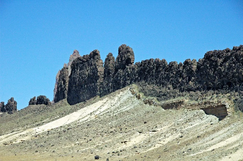
A resistant minette dike forms a natural wall after erosion removed the softer sedimentary rocks surrounding it.Aerial photographs of Shiprock reveal another remarkable feature.
Long, narrow ridges extend outward from the central formation for kilometers.
They look almost like enormous stone walls built across the desert.
These structures are igneous dikes.
A dike forms when magma enters a fracture in existing rock.
The magma moves through the fracture and eventually cools and solidifies.
When Shiprock’s volcanic system was active, magma did not move only through the central conduit.
It also entered fractures extending outward through the surrounding rocks.
This created thin, sheet-like bodies of igneous rock.
At the time they formed, these dikes were underground.
Today they are some of the most recognizable features of the Shiprock landscape.
Why Do the Dikes Look Like Walls Today?
Originally, the dikes were surrounded by sedimentary rocks.
They did not stand above the surface like walls.
Over millions of years, erosion removed the softer sandstone, shale, siltstone, and other surrounding sedimentary rocks more rapidly than the harder igneous material.
The resistant dikes remained.
Eventually, these once-buried sheets of magma became long ridges extending across the modern landscape.
This is another excellent example of differential erosion.
Several major dikes radiate outward from Shiprock.
The New Mexico Bureau of Geology recognizes six major dikes, while detailed U.S. Geological Survey mapping described seven dikes forming a radial pattern around the central volcanic structure.
This difference reflects how individual dikes and dike segments are classified and mapped.
One of the best-studied northeastern dikes has an exposed length of approximately 2.9 kilometers.
Detailed geological mapping shows that this dike is not simply one continuous sheet.
It consists of numerous individual segments that eventually connected as magma propagated through fractures in the surrounding rock.
Viewed from above, these dikes look like giant arms extending outward from Shiprock.
Geologically, they represent preserved pathways through which magma once moved beneath the surface.
How Did Magma Move Through the Dikes?
Detailed geological studies around Shiprock have revealed that magma movement through the crust was more complicated than simply filling one large crack.
Some dikes developed as groups of separate segments.
As magma pressure increased, fractures propagated through the surrounding rocks.
Individual cracks expanded.
Some overlapped.
Others eventually connected.
As the fractures joined together, larger and more continuous pathways developed.
USGS studies of Shiprock also found evidence that flowing magma could break apart and erode sections of the surrounding wall rock.
This process helped enlarge some parts of the magma conduits.
In certain areas, narrow dikes may have developed into wider plug-like structures.
Shiprock therefore preserves something that is rarely visible at the Earth’s surface:
the architecture of an ancient magma transport system.
Is Shiprock the Entire Ancient Volcano?
No.
This is one of the most common misunderstandings about Shiprock.
Looking at the formation today and saying, “This is a 30-million-year-old volcano,” is only partly correct.
Most of the original volcanic landform is gone.
The volcanic cone, crater, surface deposits, and other upper parts of the system have largely been removed by erosion.
Shiprock represents deeper and more resistant parts of the ancient volcanic system.
The landscape visible today therefore looks very different from the landscape that existed when volcanic activity was occurring.
A structure that once existed hundreds of meters underground now towers above the surrounding desert.
That reversal is one of the reasons Shiprock is such an extraordinary geological site.
Why Is Shiprock So Jagged?
Shiprock does not have the smooth cone shape commonly associated with volcanoes.
Instead, it consists of steep walls, sharp ridges, towers, and irregular pinnacles.
There are several reasons for this.
First, Shiprock is not composed of one perfectly uniform rock mass.
Its geology includes:
- tuff breccia,
- fragmented country rock,
- minette intrusions,
- fractures,
- joints,
- and other structural variations.
These materials do not all respond to weathering and erosion in the same way.
Fractures also allow water, ice, and chemical weathering to penetrate the rock.
Over millions of years, weaker sections are removed more rapidly while more resistant sections remain.
This uneven erosion gradually created the steep and jagged appearance visible today.
Shiprock’s dramatic shape is therefore the combined result of its volcanic structure and millions of years of erosion.
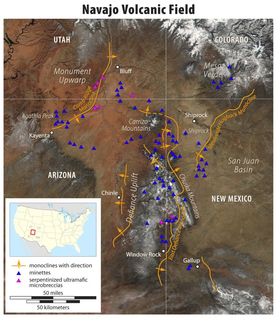
Shiprock did not form as an isolated geological event.
It is one of the best-known features of the Navajo Volcanic Field, a broad region of ancient volcanic activity across parts of New Mexico and Arizona.
The field contains numerous:
- volcanic necks,
- diatremes,
- dikes,
- plugs,
- breccia bodies,
- minette intrusions,
- and other unusual igneous formations.
Many of these volcanic structures have experienced extensive erosion.
As a result, formations that originally developed beneath ancient volcanoes are now exposed at the surface.
This is extremely valuable to geologists.
Inside an active volcano, the pathways used by magma may be buried hundreds or thousands of meters underground and cannot be directly examined.
At Shiprock, erosion has essentially performed a natural geological dissection.
It removed much of the rock that once covered the volcanic system and exposed parts of its ancient magma plumbing.
What Shiprock Tells Us About Magma Movement
The combination of the central volcanic throat and surrounding dikes makes Shiprock particularly useful for understanding how magma travels through the Earth’s crust.
Magma does not simply rise vertically through one perfectly cylindrical pipe.
Instead, it takes advantage of fractures and weaknesses in the surrounding rock.
Magma can:
- force fractures open,
- move vertically,
- spread laterally,
- create branching pathways,
- break pieces from surrounding rocks,
- and eventually become concentrated in larger conduits.
Detailed studies of Shiprock’s minette dikes show that some of these structures consist of multiple segments rather than one continuous fracture.
These segments grew, interacted, overlapped, and eventually joined together as magma moved through the crust.
This makes Shiprock an exceptional natural example of processes that normally occur far underground.
Shiprock is not important only because of its geology.
It has deep cultural significance for the Diné, or Navajo people.
Its Diné name, Tsé Bitʼaʼí, is commonly translated as “rock with wings.”
Shiprock is an important landmark within the cultural landscape of the Navajo Nation and the surrounding Shiprock community.
The formation is also regarded as sacred.
For this reason, Shiprock should not be treated simply as an unusual geological formation or adventure destination.
It is part of a living cultural landscape.
Rock climbing is prohibited on Navajo Nation lands and sacred monuments.
Visitors should respect Navajo Nation regulations, cultural traditions, access restrictions, private land, and the spiritual importance of the site.
Geological curiosity should always be balanced with respect for the people whose history and culture are connected to the landscape.
Is Shiprock an Active Volcano?
No.
Shiprock is the deeply eroded remnant of volcanic activity that occurred approximately 30 million years ago.
There is no evidence that Shiprock represents an active volcanic system today.
The magma that once moved through its dikes and conduits cooled and solidified tens of millions of years ago.
What remains is the geological structure left behind after volcanic activity ended and erosion removed much of the surrounding landscape.
Why Is Shiprock Geologically Important?
Shiprock’s importance comes from much more than its spectacular appearance.
It allows geologists to examine structures that normally remain hidden beneath volcanic systems.
Within one landscape, researchers can study:
- volcanic conduit development,
- explosive volcanism,
- brecciation,
- magma intrusion,
- minette magma,
- radial dike systems,
- fracture propagation,
- differential erosion,
- and long-term landscape evolution.
The relationship between the central formation and the surrounding dikes is especially important.
The central volcanic throat preserves part of the main volcanic conduit.
The radiating dikes preserve fractures through which magma moved through the surrounding crust.
Millions of years of erosion exposed both.
Without erosion, much of this volcanic plumbing system would still be hidden underground.
That is what makes Shiprock scientifically remarkable.
It is not merely the remains of an ancient volcano.
It is a natural cross-section through part of an ancient volcanic system that erosion has slowly uncovered.
Frequently Asked Questions About Shiprock
What is Shiprock?
Shiprock is a large volcanic landform in northwestern New Mexico. It represents deeply eroded parts of an ancient volcanic system that formed approximately 30 million years ago.
How did Shiprock form?
Magma rose through fractures in the Earth’s crust and created a complex volcanic system containing breccia, intrusive rocks, and dikes. Explosive processes may also have involved interaction between magma and groundwater. After volcanic activity ended, millions of years of erosion removed the softer surrounding rocks and exposed the harder volcanic structures.
Is Shiprock a volcano?
Shiprock is the eroded remnant of an ancient volcanic system rather than a complete volcanic cone. Most of the original surface volcano has disappeared.
How old is Shiprock?
The volcanic activity responsible for Shiprock occurred approximately 30 million years ago during the Oligocene Epoch.
What type of rock is Shiprock made of?
The central structure contains large amounts of volcanic tuff breccia and fractured rock and is cut by igneous intrusions composed of unusual potassium-rich minette.
How high is Shiprock?
Shiprock rises approximately 480 meters, or about 1,580 feet, above the surrounding high-desert plain.
Why is Shiprock so much higher than the surrounding land?
Shiprock’s resistant volcanic rocks eroded more slowly than many of the surrounding sedimentary rocks. Over millions of years, differential erosion lowered the surrounding landscape and exposed the harder volcanic structure.
What are the long rock walls around Shiprock?
They are igneous dikes. Magma entered fractures in surrounding rocks and solidified underground. Later erosion removed the softer host rocks, leaving the harder dikes standing as long wall-like ridges.
Was Shiprock originally underground?
Yes. Geological interpretations suggest that the rocks now exposed at Shiprock may have formed approximately 750 to 1,000 meters below the ancient land surface.
Is Shiprock an active volcano?
No. The volcanic activity associated with Shiprock occurred tens of millions of years ago, and there is no evidence that it is an active volcanic system today.
Can you climb Shiprock?
No. Rock climbing on Navajo Nation sacred monuments and lands is prohibited. Visitors should respect Navajo Nation regulations and the cultural significance of the site.
Conclusion
The story of Shiprock is not simply the story of how a volcano formed.
It is also the story of how a volcano disappeared.
Around 30 million years ago, magma rose beneath what is now northwestern New Mexico.
It fractured surrounding rocks, moved through underground conduits, and entered long cracks that became igneous dikes.
Explosive volcanic processes produced a complex central structure containing broken rock, breccia, and intrusive material.
Then the volcanic activity ended.
Erosion took over.
For millions of years, the upper parts of the ancient volcanic system and the surrounding sedimentary rocks were gradually removed.
The land surface became lower.
Structures that had once been buried hundreds of meters underground became exposed.
The resistant central volcanic throat and its radiating dikes remained while much of the landscape around them disappeared.
That is why Shiprock is so unusual.
When we look at it today, we are not simply looking at an impressive desert mountain.
We are looking into the exposed interior of a volcanic system that was active around 30 million years ago.
References
New Mexico Bureau of Geology & Mineral Resources. The Ship Rock Landform – New Mexico Geology Virtual Tour.
New Mexico Bureau of Geology & Mineral Resources. Frequently Asked Questions About New Mexico Volcanoes – Is Shiprock a Volcano?
Delaney, P. T., and Pollard, D. D. (1981). Deformation of Host Rocks and Flow of Magma During Growth of Minette Dikes and Breccia-Bearing Intrusions Near Ship Rock, New Mexico. U.S. Geological Survey Professional Paper 1202.
U.S. Geological Survey. Geological Investigations of Minette Dikes, Breccias, and Intrusions Near Ship Rock, New Mexico.
Navajo Nation Parks & Recreation Department. Navajo Tribal Park Rules and Regulations.
Navajo Nation – Shiprock River Vision Master Plan. Community Vision, Mission and Cultural Values.
New Mexico Tourism Department. Navajo Nation and Shiprock – Northwest New Mexico.