


")


The Rio de Janeiro Harbor is a prominent port located in the city of Rio de Janeiro, Brazil. It is one of the largest and busiest ports in the country and serves as a vital gateway for international trade and maritime activities in Brazil. The harbor is situated along the southeastern coast of Brazil, at the entrance of Guanabara Bay.
Historically, the Rio de Janeiro Harbor has played a significant role in the development and growth of Rio de Janeiro as a major urban center. The natural harbor provided a strategic location for maritime activities and trade, attracting explorers, colonizers, and traders throughout history. It served as the main port for the Portuguese during the colonial era and later became an important hub for the exportation of Brazilian commodities, such as coffee, sugar, and minerals.
Today, the Rio de Janeiro Harbor continues to be a vital economic and logistical hub for Brazil. It handles a wide range of cargo, including containers, bulk commodities, and petroleum products. The port facilities are equipped with modern infrastructure and technology to accommodate large vessels and facilitate efficient cargo handling operations.
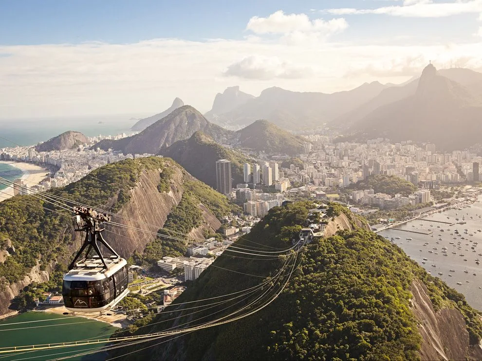
In addition to its economic importance, the Rio de Janeiro Harbor is also renowned for its picturesque beauty and iconic landmarks. The harbor is framed by stunning natural landscapes, including the famous Sugarloaf Mountain and the Corcovado Mountain with the statue of Christ the Redeemer. These landmarks, along with the sandy beaches and lush forests, make the harbor area a popular tourist destination.
The Rio de Janeiro Harbor has undergone significant developments and improvements in recent years to enhance its capacity and efficiency. Projects have been implemented to deepen the harbor channel, expand the port infrastructure, and improve access for larger vessels. These initiatives aim to bolster Brazil’s maritime industry and strengthen its position as a key player in international trade.
Overall, the Rio de Janeiro Harbor stands as a symbol of Brazil’s maritime heritage and economic significance. With its strategic location, modern facilities, and scenic surroundings, it continues to be a bustling port that connects Brazil with the global economy while captivating visitors with its natural beauty.
Geological Setting of The Rio de Janeiro Harbor
The geological setting of the Rio de Janeiro Harbor is closely tied to the unique geography and geology of the region. The harbor is situated at the entrance of Guanabara Bay, which is surrounded by a diverse range of geological features.
The primary geological feature of the area is the Tijuca Massif, a granite mountain range that dominates the landscape. The Tijuca Massif is a result of volcanic activity that occurred around 520 million years ago during the Cambrian period. It is composed of granite and gneiss rocks, which provide a solid foundation for the harbor infrastructure.
The bay itself, including the harbor area, is a product of both tectonic and erosional processes. It is classified as a ria, which is a drowned river valley formed by the rising sea levels at the end of the last ice age. The bay is surrounded by steep hills and mountains, including the iconic Sugarloaf Mountain and Corcovado Mountain, which are composed of granite and other igneous rocks.
The harbor area also features several islands, the largest of which is Governador Island. These islands are composed of sedimentary rocks, such as sandstone and shale, that were deposited over time. The sedimentary layers in the harbor area often contain fossil remains, providing valuable insights into the region’s geological history.
Another important geological aspect of the Rio de Janeiro Harbor is its proximity to the South Atlantic Ocean. The harbor is exposed to the ocean’s dynamic processes, including wave action, tides, and currents. These coastal processes have influenced the formation of beaches, sandbars, and tidal flats in the harbor area.
It’s worth noting that the geological setting of the Rio de Janeiro Harbor also presents some challenges. The granite rocks of the Tijuca Massif, while providing a stable foundation, can make dredging and construction more challenging. Additionally, the steep topography and the potential for heavy rainfall can lead to erosion and slope instability in some areas.
Overall, the geological setting of the Rio de Janeiro Harbor is characterized by a mix of volcanic, sedimentary, and igneous rocks, shaped by tectonic and erosional processes over millions of years. It is this unique combination of geological features that contributes to the natural beauty and complexity of the harbor and its surroundings.
The Rio de Janeiro Harbor Landforms
The Rio de Janeiro Harbor and its surrounding area contain several notable landforms that contribute to its distinctive geography. Here are some key landforms in and around the harbor:
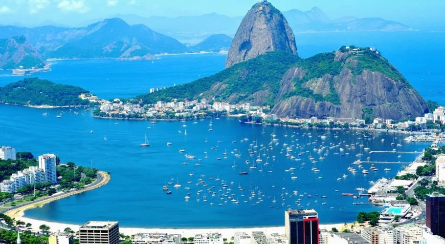
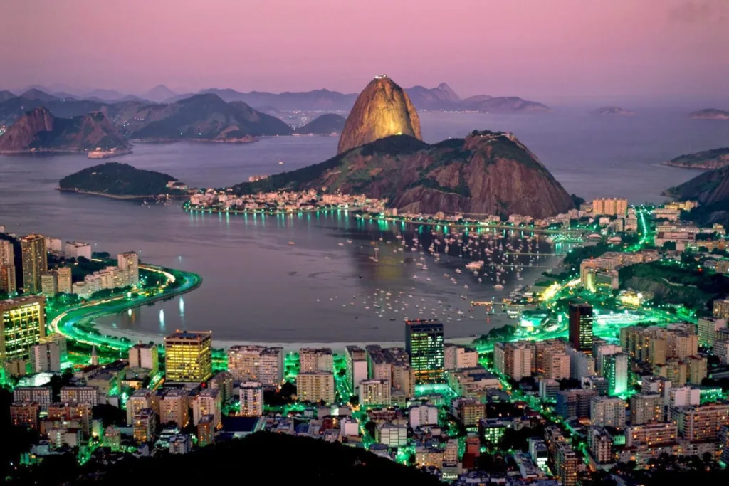
- Guanabara Bay: The harbor itself is part of Guanabara Bay, a large inlet located on the southeastern coast of Brazil. The bay stretches approximately 31 miles (50 kilometers) inland and has a surface area of about 153 square miles (398 square kilometers). It is surrounded by mountains and hills, creating a picturesque setting.
- Sugarloaf Mountain (Pão de Açúcar): One of Rio de Janeiro’s most famous landmarks, Sugarloaf Mountain is a towering granite peak that rises 1,299 feet (396 meters) above the bay. It is characterized by its distinctive shape, resembling a sugarloaf. Visitors can take cable cars to reach its summit, which offers panoramic views of the harbor, city, and surrounding areas.
- Corcovado Mountain: Located in the Tijuca Forest National Park, Corcovado Mountain is home to the iconic statue of Christ the Redeemer (Cristo Redentor). The mountain stands at an elevation of 2,329 feet (710 meters) and provides stunning vistas of the harbor and Rio de Janeiro. It is composed of granite and gneiss rocks.
- Tijuca Massif: The Tijuca Massif is a granite mountain range that encompasses a significant portion of the harbor area. It includes various peaks and hills, such as Pedra da Gávea and Pedra Bonita. The Tijuca Massif is covered by the Tijuca Forest, one of the largest urban forests in the world.
- Ilha de Paquetá: Situated in Guanabara Bay, Ilha de Paquetá is an island known for its tranquil atmosphere and preserved natural beauty. The island offers sandy beaches, bike paths, and car-free streets, making it a popular destination for relaxation and leisure.
- Ilha do Governador: Governador Island is the largest island in Guanabara Bay. It is connected to the mainland by a series of bridges and serves as a residential and industrial area. The island has a diverse landscape, including hills, bays, and marshy areas.
- Beaches: The harbor area is renowned for its stunning beaches, which attract locals and tourists alike. Copacabana Beach, Ipanema Beach, and Flamengo Beach are among the most famous and picturesque in Rio de Janeiro. These sandy stretches offer breathtaking views of the bay and contribute to the region’s allure.
These landforms, with their unique shapes and natural beauty, enhance the scenic charm of the Rio de Janeiro Harbor area and make it an enticing destination for visitors from around the world.
Sedimentation
Sedimentation plays a crucial role in shaping the Rio de Janeiro Harbor and its surrounding areas. It refers to the process by which sediments, such as sand, silt, and clay, are transported and deposited by various agents, such as water, wind, or ice.
In the case of the Rio de Janeiro Harbor, sedimentation occurs primarily through the action of water in the form of rivers, tides, and ocean currents. The sediment-laden rivers flowing into the harbor, such as the Guanabara Bay watershed, bring along eroded material from the surrounding land. These sediments are then transported and eventually settle within the bay and harbor.
Sedimentation can have both positive and negative impacts on the harbor. On the positive side, it contributes to the natural accretion of land, forming marshes, tidal flats, and sandbars. These areas provide important habitats for various species of plants and animals, and they also help protect the coastline from erosion.
However, sedimentation can also present challenges for the harbor. The accumulation of sediments can gradually reduce the depth of the navigation channels, limiting the access of larger vessels. This requires regular dredging to maintain sufficient depths for safe navigation and to prevent sedimentation from impeding maritime activities.
Human activities, such as urbanization, deforestation, and industrialization in the watershed, can exacerbate sedimentation in the harbor. Increased soil erosion due to land development can lead to higher sediment loads in the rivers, increasing the deposition of sediments within the bay and harbor.
Efforts are made to manage sedimentation in the Rio de Janeiro Harbor. These include sediment control measures in the watershed, such as soil conservation practices and reforestation to reduce erosion. Dredging operations are also conducted periodically to remove accumulated sediments and maintain navigable channels.
Understanding sedimentation patterns and managing it effectively is crucial for maintaining the long-term viability and sustainability of the harbor. By monitoring sedimentation rates and implementing appropriate sediment control measures, the authorities can ensure the safe and efficient operation of the harbor while preserving the ecological integrity of the surrounding environment.
Geological Hazards of The Rio de Janeiro Harbor
The Rio de Janeiro Harbor and its surrounding area are prone to several geological hazards that pose challenges and risks to the region. Here are some of the notable geological hazards in the vicinity of the harbor:
- Landslides: The steep topography and abundant rainfall in the region make the area susceptible to landslides. The combination of heavy rainfall, hilly terrain, and the presence of weathered rock and soils can trigger slope instability. Landslides can threaten infrastructure, disrupt transportation, and pose risks to human settlements in the vicinity of the harbor.
- Erosion: Coastal erosion is a significant concern for the Rio de Janeiro Harbor area. Wave action, storm surges, and tidal currents can erode coastlines, leading to the loss of valuable land, including beaches and coastal infrastructure. Erosion can affect the stability of coastal structures and impact the overall resilience of the harbor.
- Seismic Activity: The region is located in a seismically active zone, and Brazil experiences occasional earthquakes. While significant seismic events are relatively rare, they have the potential to impact the infrastructure and stability of the harbor area. Earthquakes can trigger landslides, tsunamis, and ground subsidence, posing risks to buildings, port facilities, and coastal areas.
- Subsidence: Certain areas of Rio de Janeiro, including parts near the harbor, are susceptible to subsidence. Subsidence refers to the sinking or settling of the ground due to various factors, such as geological processes, groundwater extraction, and urban development. Subsidence can lead to the deformation of structures, infrastructure damage, and increased vulnerability to flooding.
- Coastal Flooding: The Rio de Janeiro Harbor area is at risk of coastal flooding due to storm surges, high tides, and sea-level rise. Low-lying coastal areas, including parts of the harbor and nearby neighborhoods, can be inundated during severe weather events, leading to property damage, disruptions to port operations, and threats to public safety.
Efforts are made to mitigate these geological hazards and reduce the risks associated with them. This includes implementing geological and geotechnical studies to assess the stability of slopes and coastal areas, implementing land-use planning strategies to avoid vulnerable zones, and constructing protective structures like seawalls to defend against erosion and flooding.
Monitoring systems for seismic activity, rainfall patterns, and coastal erosion are also in place to provide early warning and facilitate emergency response measures. These initiatives aim to enhance the resilience and safety of the Rio de Janeiro Harbor area in the face of geological hazards and promote sustainable development in the region.
FAQs
What type of rocks are found in the Rio de Janeiro Harbor area?
The Rio de Janeiro Harbor area is characterized by a variety of rocks, including granite, gneiss, sandstone, shale, and other sedimentary formations.
Are there any active volcanoes near the Rio de Janeiro Harbor?
No, there are no active volcanoes in the immediate vicinity of the Rio de Janeiro Harbor. The volcanic activity that formed the region’s geological features occurred millions of years ago.
How does sedimentation affect the Rio de Janeiro Harbor?
Sedimentation can gradually reduce the depth of navigation channels in the harbor, requiring regular dredging to maintain sufficient depths for safe maritime activities.
Is the Rio de Janeiro Harbor area prone to earthquakes?
While Brazil is located in a seismically active zone, significant earthquakes are relatively rare in the Rio de Janeiro Harbor area. However, occasional seismic activity can occur.
Are there any natural hazards associated with the topography of the Rio de Janeiro Harbor area?
Yes, the steep topography of the region makes it susceptible to landslides, which can pose risks to infrastructure and human settlements.
How is coastal erosion managed in the Rio de Janeiro Harbor area?
Coastal erosion is managed through measures such as monitoring erosion rates, implementing protective structures like seawalls, and implementing land-use planning strategies to avoid vulnerable areas.
Are there any sinkholes or subsidence issues in the Rio de Janeiro Harbor area?
Certain areas of Rio de Janeiro, including parts near the harbor, are susceptible to subsidence, which can lead to ground sinking and deformation of structures.
What risks does sea-level rise pose to the Rio de Janeiro Harbor area?
Sea-level rise poses risks of coastal flooding to low-lying areas, including the harbor. It can lead to property damage, disruptions to port operations, and threats to public safety.
Are there any historical geological events of significance in the Rio de Janeiro Harbor area?
The geological history of the region includes the volcanic activity that formed the Tijuca Massif and the natural sedimentation processes that shaped the bay and harbor over millions of years.
What measures are in place to mitigate geological hazards in the Rio de Janeiro Harbor area?
Mitigation measures include geological and geotechnical studies, land-use planning, monitoring systems for seismic activity and erosion, and the construction of protective structures like seawalls to enhance safety and resilience.


