")


profengineer
Forum Replies Created
- AuthorPosts
 profengineerModerator
Japan is a country that is prone to earthquakes due to its location along the Pacific Ring of Fire, which is an area with frequent seismic activity. Over the years, Japan has developed robust earthquake preparedness and response plans to mitigate the impact of major earthquakes. Some of the ways the Japanese plan for major earthquakes include:
- Earthquake-resistant infrastructure: Japan has implemented strict building codes and engineering standards for constructing earthquake-resistant buildings, bridges, highways, and other infrastructure. These standards are regularly updated to incorporate the latest research and technology to enhance seismic resilience.
- Seismic monitoring and early warning systems: Japan has an extensive network of seismometers and other monitoring devices to detect seismic activity and provide early warning alerts to the public and critical infrastructure. The Japan Meteorological Agency (JMA) operates an advanced earthquake early warning system called “Earthquake Early
- Warning” (EEW), which can provide seconds to minutes of warning before the arrival of strong seismic waves.
Public awareness and education: Japan places a strong emphasis on public education and awareness about earthquakes and disaster preparedness. Educational campaigns, drills, and training programs are regularly conducted at schools, workplaces, and communities to raise awareness about earthquake safety, evacuation procedures, and response protocols. - Disaster response plans and infrastructure: Japan has well-established disaster response plans at national, regional, and local levels. These plans outline the roles and responsibilities of different agencies, organizations, and stakeholders in responding to earthquakes and other disasters. Japan also has a robust disaster response infrastructure, including emergency shelters, stockpiles of food, water, and medical supplies, and transportation systems for disaster relief.
- Tsunami preparedness: Japan is also vulnerable to tsunamis triggered by earthquakes. The country has implemented extensive tsunami preparedness measures, including tsunami warning systems, evacuation plans, and tsunami-resistant infrastructure along coastal areas.
- Post-earthquake recovery and reconstruction: Japan has also developed plans and mechanisms for post-earthquake recovery and reconstruction, including financial resources, insurance programs, and support systems for affected communities and individuals.
- International collaboration: Japan collaborates with international organizations and other countries in earthquake research, technology development, and disaster management. Japan shares its knowledge, experience, and expertise in earthquake preparedness and response with other earthquake-prone regions around the world.
These are some of the ways Japan plans for major earthquakes. It’s important to note that earthquake preparedness is an ongoing process, and Japan continues to invest in research, technology, infrastructure, and public awareness to enhance its seismic resilience and minimize the impacts of earthquakes on its population and infrastructure.
profengineerModeratorScientists measure earthquakes using various techniques and instruments, including seismometers, accelerometers, and GPS receivers. These instruments are designed to detect and record ground motion caused by seismic waves generated by earthquakes.
Seismometers are the most commonly used instruments for measuring earthquakes. They are typically deployed in networks of seismic stations around the world and are designed to detect and record ground motion in multiple directions. Seismometers work by using sensors, such as pendulums or springs, to detect the movement of the ground caused by seismic waves. They generate electrical signals that are converted into seismic data, which can be analyzed to determine various parameters of an earthquake, such as its location, magnitude, and focal depth.
Accelerometers are another type of instrument used to measure earthquakes. They measure the acceleration of ground motion caused by seismic waves and can provide high-frequency data that is useful for studying the characteristics of seismic waves and the properties of the Earth’s subsurface.
GPS receivers are also used in earthquake measurement. They are used to measure ground displacement caused by tectonic movements associated with earthquakes. By tracking the precise position of GPS stations before, during, and after an earthquake, scientists can determine the amount and direction of ground movement, which provides important information about the fault behavior and the size of the earthquake.
Data from seismometers, accelerometers, and GPS receivers, along with other types of instruments, are combined to create seismic records that are used to analyze and understand earthquakes, including their location, magnitude, depth, and other characteristics. These measurements are critical for earthquake monitoring, research, and hazard assessment, and help scientists better understand earthquake processes and improve earthquake forecasting and early warning systems.
profengineerModeratorA seismoscope is a scientific instrument used to detect and measure seismic activity, particularly earthquakes. It is designed to sense the ground motion caused by seismic waves and provide a visual or mechanical indication of the shaking.
The earliest seismoscopes were simple pendulums or other mechanical devices that could detect ground motion and respond with visible or audible signals. These early seismoscopes were used to detect earthquakes and provide basic information about their intensity and duration.
In modern times, seismoscopes have evolved into sophisticated instruments that use various technologies, including sensors, accelerometers, and data loggers, to measure ground motion and record seismic data. These instruments are often deployed in seismic monitoring networks worldwide, allowing scientists to study and monitor earthquake activity, understand earthquake processes, and assess seismic hazards.
Seismoscopes can be used for a wide range of applications, including earthquake monitoring, seismic research, engineering and infrastructure design, and earthquake early warning systems. They are essential tools for seismologists, geologists, engineers, and other professionals involved in studying earthquakes and mitigating their impacts.
profengineerModeratorThe San Andreas Fault is a major geological fault located in California, USA. It is a transform fault, which means it is a boundary between two tectonic plates that are sliding horizontally past each other. The San Andreas Fault extends for about 800 miles (1,300 kilometers) through California, from the Salton Sea in the south to Cape Mendocino in the north.
The San Andreas Fault is associated with the boundary between the Pacific Plate and the North American Plate. The Pacific Plate is moving northwestward relative to the North American Plate, and the two plates are sliding past each other horizontally. This movement along the fault can result in earthquakes, as the plates are locked and then suddenly slip past each other, releasing stored energy in the form of seismic waves.
The San Andreas Fault is known for its long history of seismic activity, and it has been responsible for some of the most significant earthquakes in California’s history, including the 1906 San Francisco earthquake. It is closely monitored by seismologists and geologists due to the potential for future earthquakes along the fault. The San Andreas Fault also serves as an important natural laboratory for studying fault mechanics, earthquake processes, and tectonic plate interactions.
profengineerModerator
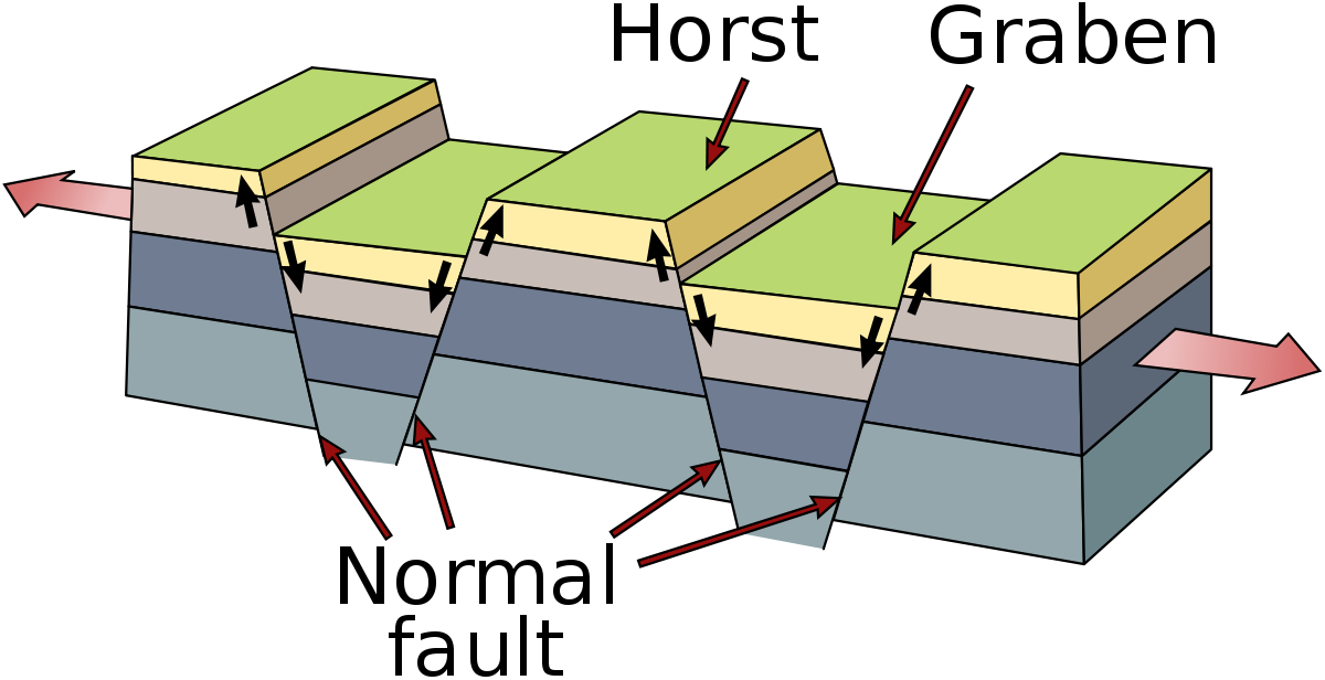
A graben and a horst are geological terms used to describe different types of features that can form along faults in the Earth’s crust.
Graben: A graben is a type of down-dropped block of land bounded by two parallel faults. It forms when the Earth’s crust is pulled apart along a fault, and the central block sinks relative to the blocks on either side. This results in a depressed block of land with steep fault scarps on both sides. Grabens are often elongated and can be found in areas of tectonic extension, such as rift valleys and divergent plate boundaries.
Horst: A horst is the opposite of a graben. It is an upthrown block of land bounded by two parallel faults. It forms when the Earth’s crust is uplifted along a fault, and the central block is elevated relative to the blocks on either side. This results in a raised block of land with steep fault scarps on both sides. Horsts can form in areas of tectonic compression, such as convergent plate boundaries and areas with folding and faulting.
Both grabens and horsts are common features associated with faulting and can be found in various geologic settings around the world. They are important in understanding the tectonic processes and structural geology of a region, and they have significant implications for landforms, landscapes, and natural resources.profengineerModeratorEarthquakes are generated along faults, which are zones of weakness in the Earth’s crust where rocks have broken and moved relative to each other. When the accumulated stress along a fault exceeds the strength of the rocks, the rocks abruptly rupture, releasing energy in the form of seismic waves that propagate through the Earth’s crust and cause ground shaking.
There are several ways in which earthquakes can be generated along faults:
- Tectonic forces: The Earth’s crust is divided into several large plates that are constantly moving due to tectonic forces. When these plates move past each other, they can create stress along faults as they interact and deform. This accumulated stress can eventually exceed the strength of the rocks, causing them to break and generate an earthquake.
- Fault slip: Fault slip occurs when rocks on either side of a fault move past each other, causing a sudden release of stored elastic strain energy. This can happen either as a result of gradual movement along a fault (creep) or as a sudden slip during an earthquake.
- Fault zone fluids: The presence of fluids, such as water or magma, along a fault can reduce the friction between the rocks, making it easier for them to slip and generate an earthquake. The movement of fluids in and out of the fault zone can also cause changes in pressure and stress, which can trigger an earthquake.
- Induced seismicity: Human activities, such as mining, reservoir-induced stress changes, and fluid injection (e.g., wastewater disposal from oil and gas operations), can also trigger earthquakes along faults. These are known as induced seismicity, and they can occur in regions where the stress on a fault is altered by human activities.
Once an earthquake is triggered along a fault, the released energy propagates as seismic waves through the Earth’s crust, causing ground shaking, surface rupture, and other seismic effects. The study of how earthquakes are generated along faults is an active field of research, and scientists continue to investigate the complex processes that contribute to seismic activity.
profengineerModeratorThe last Ice Age, also known as the Last Glacial Maximum (LGM), began approximately 26,000 years ago and ended around 11,700 years ago. It was a period of extensive glaciation, with large ice sheets covering much of North America, northern Europe, and Asia. The exact causes of the onset and termination of the last Ice Age are still debated among scientists, but multiple factors are believed to have played a role.
The onset of the last Ice Age is thought to have been triggered by a combination of changes in Earth’s orbital parameters (known as Milankovitch cycles), which affect the amount and distribution of solar energy reaching the planet, and feedback mechanisms involving ice-albedo feedback (whereby the reflection of sunlight by ice and snow leads to cooling and further ice growth) and changes in atmospheric greenhouse gas concentrations. These factors caused a gradual cooling of the climate over thousands of years, leading to the growth of large ice sheets.
The termination of the last Ice Age is thought to have been primarily driven by changes in greenhouse gas concentrations, particularly carbon dioxide (CO2), in the atmosphere. As the climate cooled during the Ice Age, large amounts of water were locked up in ice sheets, causing a drop in sea level and exposing land that was previously submerged. This resulted in changes to ocean circulation patterns and increased carbon uptake by the oceans, which in turn led to a decrease in atmospheric CO2 levels. Eventually, a threshold was crossed, and rising greenhouse gas concentrations, along with other factors, initiated a warming trend that led to the melting of the ice sheets and the end of the Ice Age.
It’s important to note that the onset and termination of an Ice Age is a complex interplay of various factors, and the exact mechanisms and timing are still the subject of ongoing research and scientific investigation.
profengineerModeratorThe Little Ice Age had significant societal and environmental impacts around the world. In Europe, it is associated with events such as the “Great Frost” of 1683-1684, when the River Thames in England froze, and the harsh winter conditions during the French Revolution in the late 18th century. In North America, the Little Ice Age is associated with episodes of extreme cold, including the “Year Without a Summer” in 1816, which had widespread impacts on agriculture and food production.
The causes of the Little Ice Age are complex and not fully understood, but factors such as changes in solar activity, volcanic eruptions, changes in atmospheric circulation patterns, and other natural and human-induced factors have been proposed as potential drivers. The Little Ice Age is often cited as an example of a significant climate change event in the relatively recent past, and its study provides insights into the natural variability of Earth’s climate system and its interactions with human societies.
profengineerModeratorAs of my knowledge cutoff date in September 2021, glacial ice covers approximately 10% of the Earth’s land surface. This includes areas covered by permanent ice and snow, such as glaciers, ice caps, and ice sheets, which are found in polar and high-altitude regions.
The two largest ice sheets on Earth are the Antarctic ice sheet, which covers the continent of Antarctica in the Southern Hemisphere, and the Greenland ice sheet, which covers most of Greenland in the Northern Hemisphere. These two ice sheets account for the majority of the world’s glacial ice. Other areas with significant glacial ice cover include the Arctic regions of Canada, Alaska, and northern Europe, as well as high mountain ranges in regions such as the Himalayas, the Andes, and the Alps.
It’s important to note that glacial ice is a dynamic component of the Earth’s system, and its extent and volume can change over time due to various factors, including climate change, precipitation patterns, and glacier dynamics. Monitoring changes in glacial ice cover and understanding their implications for climate, hydrology, and other Earth systems is an important field of research in glaciology, climatology, and related disciplines.
profengineerModeratorGround ice refers to any form of naturally occurring ice that is found within the ground, such as in soil, sediment, or rock. Ground ice forms when the temperature of the ground drops below freezing and water in the ground freezes. Ground ice can exist in various forms, including frost, ice lenses, and massive ice bodies, and can occur in different types of environments, such as permafrost regions, high-altitude areas, and cold climate regions.
Frost is the most common form of ground ice and refers to the formation of ice crystals on the surface of the ground or on objects in contact with the ground, such as plants, rocks, and buildings. Frost forms when moisture in the air comes into contact with a surface that is below freezing, causing the moisture to freeze into ice crystals.
Ice lenses are horizontal layers or bands of ice that form within the soil or sediment, typically in colder regions where the ground freezes and thaws repeatedly. They form as a result of the freezing of water that is present in the ground, and can grow and expand over time as more water freezes and accumulates.
Massive ice bodies refer to larger bodies of ground ice that can occur in the form of buried ice, ice wedges, or ice veins within rock formations. Buried ice refers to ice bodies that are buried beneath layers of soil or sediment, while ice wedges are vertical or diagonal bodies of ice that form in cracks or fissures within the ground, and ice veins are horizontal or diagonal bodies of ice that form within rocks.
Ground ice has significant implications for geological processes, such as soil erosion, slope stability, and landscape evolution, as well as for environmental processes, such as permafrost dynamics, hydrology, and climate change. The study of ground ice is an important field of research in geology, climatology, and environmental science, with applications in understanding past and present-day environmental conditions, as well as predicting future changes in cold climate regions.
profengineerModeratorPermafrost is a type of frozen ground that remains below 0 degrees Celsius (32 degrees Fahrenheit) for at least two consecutive years. It is a layer of soil, sediment, or rock that remains permanently frozen, typically found in high-latitude and high-altitude regions of the Earth, such as in the Arctic and Antarctic regions, as well as in alpine and subarctic areas.
Permafrost is formed when the ground freezes due to the accumulation of ice in the soil or sediment. It can extend to great depths, reaching hundreds of meters in some areas. Permafrost can be classified into different types based on the proportion of ice and frozen ground, including continuous permafrost, where the entire ground is frozen; discontinuous permafrost, where some areas have permafrost and others do not; and sporadic permafrost, where isolated patches of frozen ground occur within areas of unfrozen ground.
Permafrost plays a significant role in shaping the geomorphology, hydrology, and ecosystems of cold climate regions. It can impact land stability, affect water drainage patterns, alter vegetation types, and influence wildlife habitat. Changes in permafrost due to climate warming can also have significant environmental and societal impacts, including the release of greenhouse gases such as carbon dioxide and methane as organic matter thaws, increased risks of landslides, and challenges to infrastructure development and human activities in permafrost regions. The study of permafrost is an important field of research in geology, climatology, and environmental science, with implications for understanding past and future climate change, landscape evolution, and human-environment interactions.
16/04/2023 at 15:12 in reply to: What does the term periglacial mean and periglacial features? #9350profengineerModeratorThe term “periglacial” refers to the areas adjacent to the margins of glaciers or ice sheets, or areas that experience the effects of freeze-thaw processes associated with cold climates. Periglacial environments are characterized by frozen ground, including permafrost, and a range of landforms and features shaped by the action of freeze-thaw processes, such as frost heaving, frost wedging, solifluction, and patterned ground.
Periglacial features are landforms and structures that result from the freeze-thaw processes that occur in periglacial environments. Some examples of periglacial features include:
- Frost heaving: It occurs when freezing and expansion of water in the ground causes the soil or rocks to heave upwards, resulting in mounds or hummocks on the ground surface.
- Frost wedging: It occurs when water infiltrates cracks in rocks, freezes, and expands, causing the cracks to widen and rocks to break apart.
- Solifluction: It refers to the slow downslope movement of saturated soil or sediment over permafrost or frozen ground, resulting in lobes or terracettes on hillslopes.
- Patterned ground: It refers to the characteristic surface pattern of polygons, circles, or stripes formed by the sorting and movement of soil and rocks due to freeze-thaw processes.
- Pingo: It is a conical or dome-shaped hill made of ice that forms in permafrost regions due to the pressure of groundwater freezing and pushing up the overlying soil and rocks.
Periglacial features are important indicators of past and present periglacial environments and provide insights into the geomorphic processes that shape landscapes in cold climate regions. They are also of significance in various engineering and construction activities in periglacial areas, as they can impact foundation stability, infrastructure development, and land use planning.
profengineerModeratorFlash floods are rapid and destructive floods that occur suddenly with little or no warning. They are typically characterized by a sudden surge of water in a short period of time, often within hours or even minutes, and can result in significant damage to property, infrastructure, and loss of life. Flash floods are usually caused by intense or excessive rainfall, often associated with thunderstorms, tropical cyclones, or other severe weather events, that overwhelms the capacity of the local drainage system to handle the water.
Flash floods can occur in various types of environments, including urban areas, mountainous regions, desert regions, and coastal areas. They can also occur in areas with dry or arid climates, where the ground is unable to absorb the water due to its low permeability. Flash floods can be especially dangerous because of their sudden onset, fast-moving water, and the potential for debris flows, mudslides, and other hazards associated with rapidly rising water levels.
Flash floods are a significant natural hazard, and it’s important to be aware of the risks associated with flash floods and take appropriate measures for flood prevention, preparedness, and response. This includes staying informed about weather conditions, avoiding flood-prone areas during heavy rainfall or flood warnings, having an emergency plan in place, and following guidance from local authorities during flash flood events.
profengineerModeratorFloods can occur in various locations and under different circumstances, but there are some common factors that can contribute to most flood events. Some key factors include:
- Precipitation: Heavy or prolonged rainfall, snowmelt, or other forms of precipitation can overwhelm rivers, lakes, and other bodies of water, leading to flooding. High-intensity rainfall events, such as thunderstorms, tropical cyclones, or monsoons, can result in flash floods, which are rapid and destructive floods that can occur within a few hours or even minutes.
- River or coastal flooding: Flooding can occur in river basins or coastal areas due to the overflow of rivers, estuaries, or coastal areas during high tides or storm surges. River flooding can be caused by excessive rainfall, snowmelt, or a combination of both. Coastal flooding can occur due to storm surges, which are elevated sea levels caused by tropical cyclones, hurricanes, or other severe weather events.
- Topography and drainage patterns: The topography and natural drainage patterns of an area can influence how and where floods occur. Low-lying areas, floodplains, and regions with poor drainage, such as areas with clay or rock layers that do not allow water to penetrate the ground, can be more prone to flooding. Additionally, changes in land use, such as deforestation or urbanization, can alter natural drainage patterns and increase the risk of floods.
- Human activities: Human activities, such as dam failures, levee breaches, or poor land management practices, can also contribute to floods. Dam failures or levee breaches can release large volumes of water downstream, resulting in severe flooding. Poor land management practices, such as deforestation, agricultural practices, or urbanization, can alter natural drainage patterns, increase runoff, and exacerbate flooding.
- Climate change: Climate change can also influence the occurrence of floods. Changes in precipitation patterns, sea level rise, and extreme weather events associated with climate change can affect the frequency, intensity, and timing of floods in different regions of the world.
Most floods occur in low-lying areas, floodplains, river basins, and coastal areas, but floods can happen in virtually any location where conditions conducive to flooding are present. It’s important to understand the local geography, climate, and human activities in an area to assess the flood risk and take appropriate measures for flood prevention, preparedness, and response.
profengineerModeratorYes, there are stamps from various countries around the world that feature geology-related themes. Stamps are often used to commemorate important geological events, showcase significant geological features or landscapes, highlight famous geologists or scientists, and promote geoscience education and awareness. Some examples of geology-related stamps include:
- Geological maps: Stamps featuring geological maps, which depict the distribution and composition of rocks, minerals, and other geological features in an area, are a common theme. These stamps may highlight important geological formations, such as mountains, volcanoes, and fault lines, or showcase the geology of a particular region or country.
- Fossils and minerals: Stamps featuring fossils, minerals, and gemstones are also popular among collectors. These stamps may depict well-known fossils, such as dinosaur skeletons, trilobites, or ammonites, or showcase rare or iconic minerals and gemstones, such as diamonds, quartz, or gold.
- Geological landmarks: Stamps may also feature famous geological landmarks or landscapes, such as national parks, natural monuments, or UNESCO World Heritage sites known for their unique geological features, such as the Grand Canyon, Mount Everest, or the Giant’s Causeway.
- Geologists and scientists: Some stamps may highlight famous geologists, scientists, or researchers who have made significant contributions to the field of geology. These stamps may feature portraits, achievements, or important discoveries of notable geologists, such as Charles Darwin, James Hutton, or Mary Anning.
- Geoscience education and awareness: Stamps may also be issued to promote geoscience education and awareness. These stamps may showcase the importance of geology in understanding the Earth’s history, resources, and natural hazards, or promote conservation and sustainability related to geology and the environment.
These are just a few examples of the many geology-related stamps that have been issued by various countries over the years. Geology-themed stamps can be a fascinating and educational way to learn about the geological features, events, and personalities that have shaped our planet’s history.
- AuthorPosts