


")


The Fagradalsfjall volcano is situated on the Reykjanes Peninsula in Iceland, a region known for its remarkable geological and geothermal features. The Reykjanes Peninsula is located in the southwestern part of Iceland and is known for its proximity to the Mid-Atlantic Ridge, a tectonic boundary where the North American and Eurasian tectonic plates meet. This geological setting makes the Reykjanes Peninsula a hub of dynamic volcanic and geothermal activity.
Geological Significance and Activity
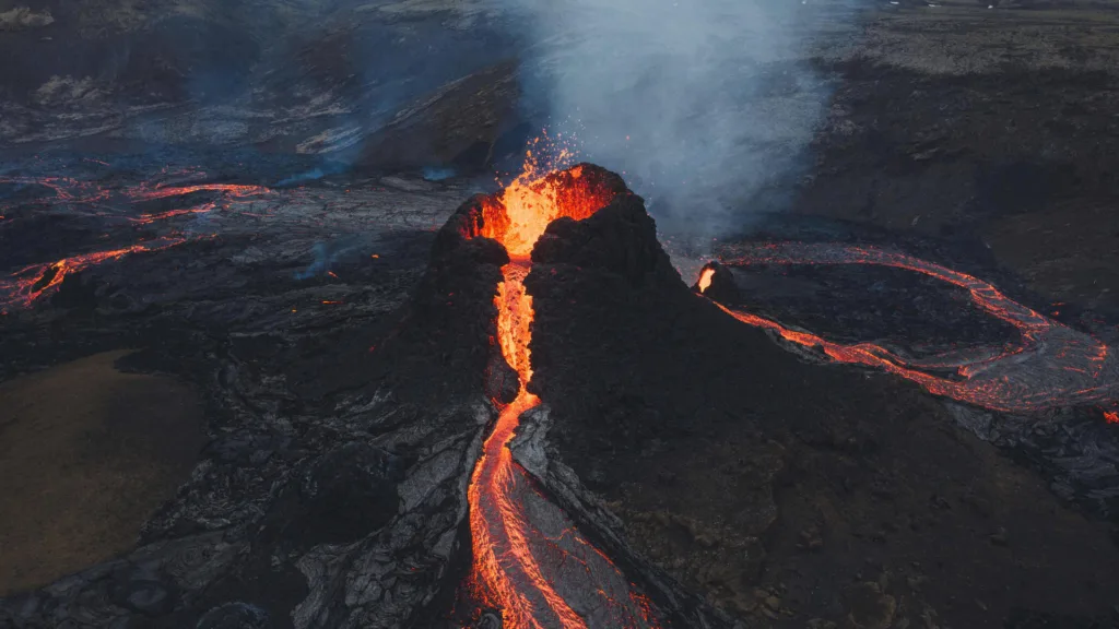
Fagradalsfjall is a relatively young and active volcano within the Reykjanes Peninsula. Its emergence into the global spotlight occurred in March 2021 when it erupted after a period of seismic activity. The eruption marked the first time in over 800 years that a volcanic event had occurred in this particular area. The eruption is characterized by its effusive style, where molten lava flows out relatively calmly compared to more explosive volcanic eruptions.
The volcanic activity at Fagradalsfjall holds significant geological importance for scientists and researchers. It provides a unique opportunity to study the initial stages of volcanic formation, lava flow dynamics, and the interaction between molten rock and the surrounding landscape. Such insights contribute to a deeper understanding of volcanic processes and can help improve predictive models for volcanic activity in similar geological settings worldwide.
Tourism and Local Impact
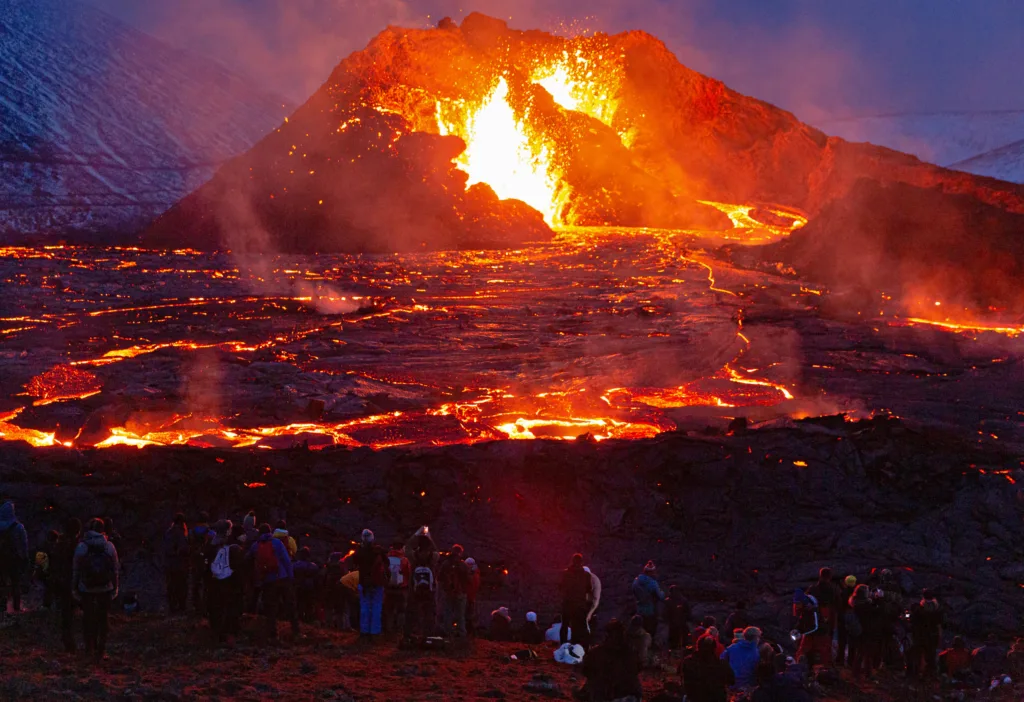
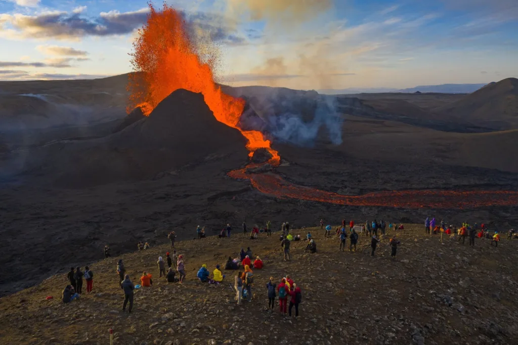
The eruption at Fagradalsfjall has also had a considerable impact on tourism and local economies. While volcanic eruptions can pose risks to nearby communities, the relatively mild and predictable nature of the Fagradalsfjall eruption has allowed for safe observation from a distance. This has attracted tourists, geologists, and nature enthusiasts to witness the spectacle of flowing lava and the raw power of nature.
Tourism related to volcanic activity can provide economic opportunities for local businesses, tour operators, and accommodation providers. However, it also requires responsible management to ensure the safety of visitors and the preservation of the fragile volcanic environment. Government agencies and local authorities have been tasked with managing the influx of visitors and setting up safe viewing areas to minimize risks.
Geological Context of Iceland’s Tectonic Activity
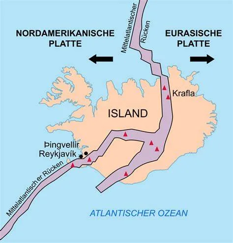
Iceland is situated on the Mid-Atlantic Ridge, a vast underwater mountain range that runs down the center of the Atlantic Ocean. This ridge marks the boundary between the North American and Eurasian tectonic plates. The movement of these plates is responsible for the unique and highly active geology of Iceland.
The Mid-Atlantic Ridge is a divergent boundary, where the two tectonic plates are moving away from each other. As they pull apart, magma from the Earth’s mantle rises to fill the gap, creating new crust and contributing to the formation of new land. This process is responsible for the volcanic activity that characterizes Iceland.
Reykjanes Peninsula’s Geologic Significance and Relation to Fagradalsfjall
The Reykjanes Peninsula is located in the southwestern part of Iceland and sits directly on the Mid-Atlantic Ridge. This region is known for its intense tectonic and geothermal activity, making it a hotspot for geological research and exploration.
The Reykjanes Peninsula is notable for being part of the broader Reykjanes Volcanic Belt, which extends across the peninsula and into the surrounding seafloor. This belt is characterized by a complex system of fissures, faults, and volcanic features. It is an area of high volcanic and seismic activity, shaped by the interaction of the North American and Eurasian plates.
Fagradalsfjall’s significance lies in its role as a manifestation of this ongoing tectonic activity. The eruption at Fagradalsfjall is a direct result of the movement of the plates along the Mid-Atlantic Ridge. As the plates pull apart, magma rises from the mantle through fractures and weaknesses in the crust, eventually reaching the surface as a volcanic eruption. Fagradalsfjall’s eruption is one of the ways in which Iceland’s landscape is continually being shaped and renewed.
Furthermore, the Reykjanes Peninsula is home to a variety of geothermal features, including hot springs, mud pots, and geysers. These features are a result of the heat generated by the interaction of magma with water and the Earth’s crust. The Blue Lagoon, a famous geothermal spa, is also located on the Reykjanes Peninsula.
In summary, the Reykjanes Peninsula’s significance in terms of geology is closely tied to its location on the Mid-Atlantic Ridge. The ongoing tectonic activity in this region, including the eruption at Fagradalsfjall, is a direct result of the movement of the North American and Eurasian plates. This dynamic geological environment has shaped the landscape, contributed to the formation of new land, and created unique geothermal features that draw both scientific interest and tourism.
Monitoring and Research of Volcanic Activity at Fagradalsfjall
Monitoring volcanic activity is crucial for understanding the behavior of an eruption, assessing potential hazards, and providing timely information to local communities and authorities. The eruption at Fagradalsfjall was closely monitored using a combination of methods and technologies:
- Seismic Monitoring: Seismic sensors detect ground vibrations caused by magma movement and other geological processes associated with volcanic activity. By analyzing seismic data, scientists can determine the depth, location, and intensity of magma movements, helping to predict the progression of the eruption.
- GPS and Satellite Imagery: Global Positioning System (GPS) receivers and satellite imagery are used to monitor ground deformation. These methods help researchers track changes in the landscape’s shape and elevation, providing insights into magma migration and potential surface rupture.
- Gas Monitoring: Volcanic gases released during an eruption can provide valuable information about the magma’s composition, temperature, and potential hazards. Instruments such as gas spectrometers measure gas concentrations in the air and help predict changes in volcanic activity.
- Webcams and Visual Observations: Real-time webcams and direct visual observations from safe vantage points allow scientists and the public to monitor the eruption’s behavior, including the intensity of lava flows, the occurrence of lava fountains, and changes in the eruption’s dynamics.
- Drones and Aerial Surveys: Drones equipped with cameras and sensors provide detailed aerial imagery of the eruption site, allowing researchers to assess lava flow patterns, growth of new landforms, and changes in the landscape.
- Lava Sampling and Analysis: Researchers collect samples of lava for laboratory analysis to understand its chemical composition, mineralogy, and other characteristics. This information helps in deciphering the magmatic processes occurring beneath the surface.
Involvement of Research Institutions
The eruption at Fagradalsfjall attracted both local and international research institutions eager to study the eruption’s behavior and gain insights into volcanic processes. Some of the key areas of research and study include:
- Eruption Dynamics: Scientists studied the eruption’s progression, the frequency of lava fountaining, and the factors influencing lava flow rates. This information helps improve our understanding of how lava eruptions evolve over time.
- Lava Composition and Origin: Analysis of lava samples provided insights into the chemical composition and source of the magma. Researchers could infer the depth and characteristics of the magma chamber beneath the volcano.
- Volcanic Hazards and Mitigation: Research focused on assessing potential hazards to nearby communities and infrastructure. Understanding the eruption’s behavior helped authorities make informed decisions about evacuations and safety measures.
- Volcanic Processes: The Fagradalsfjall eruption offered a unique opportunity to study the initial stages of volcanic activity, shedding light on the processes that lead to the formation of new land, the interaction between lava and the landscape, and the ways in which volcanoes shape the Earth’s surface.
Local universities, geological agencies, and international research organizations collaborated to gather data, share findings, and enhance our understanding of the eruption’s significance within the context of Iceland’s geology and global volcanic processes. The eruption served as a living laboratory for studying volcanic phenomena and advancing our knowledge of the Earth’s dynamic processes.
Geological Background of the Reykjanes Peninsula
Iceland’s Tectonic Setting:
Iceland is situated in the North Atlantic Ocean and is part of the larger tectonic framework known as the Mid-Atlantic Ridge. The Mid-Atlantic Ridge is a divergent boundary where the North American and Eurasian tectonic plates are moving away from each other. This movement creates a gap where molten material from the Earth’s mantle rises to fill the void, leading to volcanic activity and the formation of new crust.
Location on the Mid-Atlantic Ridge:
Iceland’s location on the Mid-Atlantic Ridge makes it an area of intense geological activity. The ridge runs down the center of the Atlantic Ocean, separating the North American plate to the west from the Eurasian plate to the east. Iceland itself straddles the boundary between these two plates, making it a hotspot for volcanic and tectonic processes.
Unique Geological Features of the Reykjanes Peninsula:
The Reykjanes Peninsula, located in the southwestern part of Iceland, is particularly notable for its unique geological features, many of which result from the interaction of the North American and Eurasian plates:
1. Rift Zones and Fissures: The Reykjanes Peninsula is characterized by numerous rift zones and fissures, which are fractures in the Earth’s crust. These features are evidence of the ongoing tectonic activity and the gradual separation of the two tectonic plates. The peninsula’s landscape is shaped by these fissures, with lava flows and volcanic activity often concentrated along them.
2. Volcanic Activity: The Reykjanes Peninsula is part of the broader Reykjanes Volcanic Belt, which extends across the peninsula and into the surrounding seafloor. This region experiences frequent volcanic eruptions, both on land and under the ocean. The Fagradalsfjall eruption in 2021 is one of the recent examples of volcanic activity on the peninsula.
3. Geothermal Features: The interaction between magma and water creates an abundance of geothermal activity on the Reykjanes Peninsula. Hot springs, mud pots, and geysers are common features, offering a glimpse into the Earth’s geothermal energy potential.
4. Mid-Atlantic Ridge Surface Expression: The Reykjanes Peninsula provides a surface expression of the Mid-Atlantic Ridge’s tectonic processes. It’s a place where visitors can witness the ongoing separation of tectonic plates, leading to the formation of new land and the exposure of the Earth’s interior through volcanic and geothermal activity.
5. The Blue Lagoon: Perhaps one of the most famous geothermal attractions in the world, the Blue Lagoon is located on the Reykjanes Peninsula. It is a unique spa and wellness center set in a volcanic landscape, with mineral-rich waters heated by the Earth’s geothermal energy.
In summary, the Reykjanes Peninsula’s geological features are a direct result of its location on the Mid-Atlantic Ridge and the ongoing tectonic processes between the North American and Eurasian plates. Its rift zones, volcanic activity, geothermal features, and the famous Blue Lagoon all contribute to its unique geological identity and make it a prime destination for those interested in the Earth’s dynamic processes.
Eruption History and Activity on the Reykjanes Peninsula
The Reykjanes Peninsula has a history of both historical and geological volcanic activity. While some of its eruptions might not be well-documented due to their remoteness and historical context, notable eruptions include:
1. Historical Eruptions: In the recorded history of Iceland, eruptions have occurred in the Reykjanes Peninsula region, with some dating back to the settlement era. The most recent significant eruption prior to the Fagradalsfjall eruption occurred around 1240, leading to the formation of the Eldvörp lava fields.
2. Geological Activity: The Reykjanes Peninsula is situated along the Mid-Atlantic Ridge, which means that it experiences ongoing geological activity such as earthquakes and ground deformation. These signals of tectonic movement and magma migration are indicators of the region’s dynamic nature.
Ongoing Fagradalsfjall Eruption:
Start and Progression: The Fagradalsfjall eruption began on March 19, 2021, after a period of increased seismic activity in the region. The eruption started with the opening of a fissure on the southwestern slopes of Fagradalsfjall, allowing molten magma to reach the surface. The eruption has been characterized by its relatively calm and effusive nature, with lava flows steadily advancing across the landscape.
Eruption Characteristics:
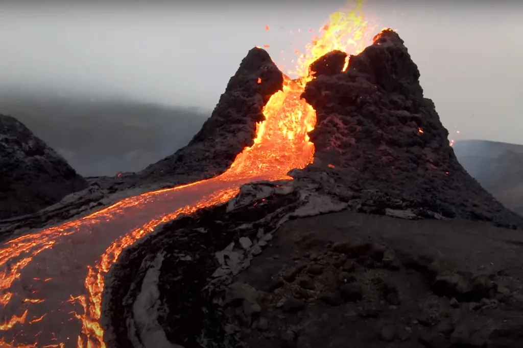
1. Fissure Eruption: The eruption is a classic example of a fissure eruption, where magma emerges through a linear crack in the Earth’s crust. This type of eruption often leads to the creation of extensive lava fields.
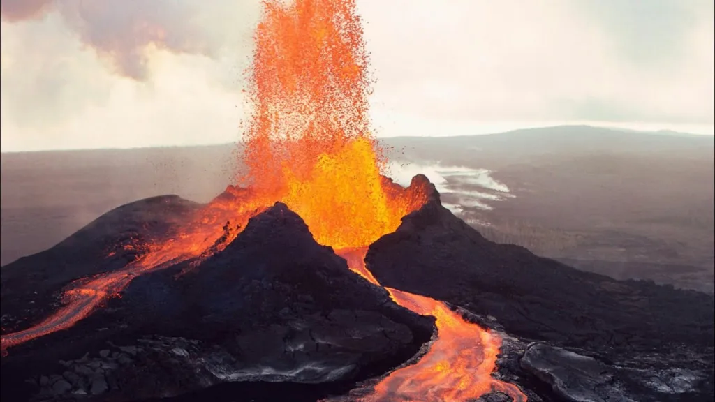
2. Effusive Lava Flows: The Fagradalsfjall eruption is primarily characterized by the effusive flow of lava. Rather than explosive eruptions with ash and pyroclastic material, the lava gently flows across the terrain, creating new landforms in the process.
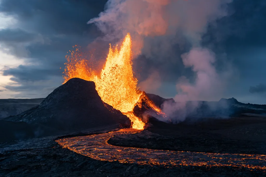
3. Lava Fountains: While the eruption is mainly effusive, lava fountains have been observed intermittently. These fountains occur when gas bubbles in the magma reach the surface, propelling the lava into the air. These events add dynamic visual elements to the eruption.
4. Volcanic Gases: The eruption releases various volcanic gases, including water vapor, carbon dioxide, and sulfur dioxide. Monitoring these gases is crucial for assessing potential hazards and their impact on air quality.
5. Accessibility and Tourism: The relatively predictable and safe nature of the eruption has allowed for controlled tourism and observation. Visitors have been able to witness the eruption from designated viewing areas, providing a unique opportunity to experience an active volcanic event.
As of my last knowledge update in September 2021, the Fagradalsfjall eruption was ongoing, and developments beyond that time are not included. For the most current and detailed information, I recommend consulting official geological and volcanic monitoring sources or recent news updates.
Volcanic Processes Causing the Fagradalsfjall Eruption
The Fagradalsfjall eruption is the result of several interconnected volcanic processes that occur beneath the Earth’s surface. Here’s an explanation of these processes:
1. Fissure Eruption: The Fagradalsfjall eruption is a type of fissure eruption. It occurs when magma from within the Earth’s mantle rises through fractures or fissures in the Earth’s crust. In the case of Fagradalsfjall, a linear crack or fissure opened up on the slopes of the volcano, allowing molten magma to reach the surface.
2. Magma Migration: Magma is molten rock that forms beneath the Earth’s surface. It is generated by the partial melting of the Earth’s mantle. As magma forms, it is less dense than the surrounding solid rock, causing it to rise due to buoyancy. The magma migrates through conduits and fractures, often following paths of least resistance.
3. Effusive Lava Flows: The magma that reaches the surface during a fissure eruption is often relatively fluid. This type of magma is called basaltic magma. When basaltic magma erupts, it can flow out of the fissure and form lava flows. These lava flows can be relatively slow-moving and travel across the landscape, covering areas with new volcanic rock.
4. Lava Fountains: Lava fountains occur when gas-rich magma reaches the surface. As the magma rises, dissolved gases, primarily water vapor and carbon dioxide, come out of solution due to decreasing pressure. This rapid expansion of gases propels the magma into the air, creating fiery fountains of lava that can reach impressive heights.
Phenomena Associated with the Eruption:
1. Volcanic Gases: Volcanic gases are released during volcanic eruptions. These gases include water vapor, carbon dioxide, sulfur dioxide, hydrogen sulfide, and others. Volcanic gases can have a significant impact on local air quality, weather patterns, and the Earth’s atmosphere. Monitoring these gases provides insights into the eruption’s behavior and its potential hazards.
2. Ash Emissions: While the Fagradalsfjall eruption is characterized by effusive lava flows, some explosive activity can lead to the release of volcanic ash. Volcanic ash consists of fine rock particles and glass fragments that can be carried by winds over long distances. Ash emissions can disrupt air travel, impact respiratory health, and influence regional weather patterns.
3. Pyroclastic Material: Although the Fagradalsfjall eruption is relatively effusive, some explosive events can generate pyroclastic material. This term refers to a mixture of hot gases, ash, and volcanic fragments that move rapidly down the flanks of a volcano. Pyroclastic flows can be extremely hazardous and destructive.
In the context of the Fagradalsfjall eruption, the volcanic processes involve the ascent of magma through a fissure, the effusion of lava flows, occasional lava fountains, and the release of volcanic gases. These processes collectively shape the eruption’s behavior and contribute to the dynamic and ever-changing nature of volcanic events.
Future Outlook of the Eruption
Predicting the exact duration of a volcanic eruption is challenging, as it depends on various factors, including the available magma, the plumbing system beneath the volcano, and the ongoing tectonic processes. The Fagradalsfjall eruption’s longevity could range from months to years. Similar fissure eruptions in Iceland’s history have lasted for various durations.
As the eruption progresses, there might be changes in the location of the fissure activity, variations in lava flow rates, and potential shifts in the style of eruption. Scientists will continue to monitor the eruption’s behavior using various methods to gather data and improve their understanding of the processes driving the volcanic activity.
Impact on Future Geological Activity:
The eruption at Fagradalsfjall is just one example of the ongoing geological activity on the Reykjanes Peninsula, which is situated on the dynamic Mid-Atlantic Ridge. While this eruption might not directly trigger larger volcanic events in the region, it contributes to the geological processes that shape the landscape and build new land over time. The knowledge gained from studying this eruption can help improve our understanding of the broader tectonic and volcanic activity in the region.
Implications for Understanding Volcanic Activity and Climate:
Studying volcanic eruptions like the one at Fagradalsfjall provides valuable insights into the processes that drive volcanic activity. This eruption offers an opportunity to observe the behavior of magma as it moves from the Earth’s mantle to the surface, shedding light on the factors that influence eruption style, magma composition, and lava flow dynamics.
Volcanic eruptions can also have implications for climate, depending on the amount of volcanic gases and particles released into the atmosphere. While the Fagradalsfjall eruption is relatively small in scale compared to some historical eruptions, it contributes to our understanding of how volcanic emissions can impact the atmosphere and potentially influence short-term climate patterns.
In summary, the future of the Fagradalsfjall eruption remains uncertain, and its duration could vary. The eruption’s impact on future geological activity is more about contributing to our understanding of the broader geological processes in the region. Additionally, studying this eruption can improve our knowledge of volcanic activity and its potential interactions with climate, adding to the wealth of information scientists use to understand Earth’s dynamic systems.
Touristic and Economic Impact of the Eruption
The eruption at Fagradalsfjall has had a significant impact on tourism and the local economy, drawing both tourists and researchers to the area:
1. Tourist Attraction: The eruption’s spectacular visual displays of flowing lava, occasional lava fountains, and the raw power of nature have attracted tourists, nature enthusiasts, and photographers from around the world. Witnessing an active volcanic eruption is a rare and awe-inspiring experience, making it a major draw for those seeking unique travel opportunities.
2. Research Interest: The eruption also attracted researchers and scientists from various disciplines. Geologists, volcanologists, and earth scientists are eager to study the eruption’s behavior, lava composition, and its broader implications for understanding volcanic processes. The site offers a real-time opportunity to gather valuable data and insights.
Economic Benefits for Local Communities:
1. Increased Tourism Revenue: The influx of tourists has led to a boost in the local economy. Tourists spend money on accommodations, meals, transportation, guided tours, and other services, generating revenue for local businesses.
2. Job Opportunities: The rise in tourism activity has created job opportunities in sectors like hospitality, tourism services, transportation, and guiding. This can contribute to lowering unemployment rates and improving the overall economic well-being of the region.
3. Infrastructure Development: To accommodate the influx of tourists, there may be investments in infrastructure development, including improved roads, visitor centers, and safety facilities. These developments can have long-term benefits for the community’s infrastructure and amenities.
Balancing Tourism with Environmental and Safety Considerations:
While the eruption’s tourism potential and economic benefits are significant, there are also important considerations to ensure the sustainability and safety of the experience:
1. Environmental Preservation: The volcanic landscape is fragile, and the influx of tourists can have negative impacts on the environment if not managed carefully. Measures to control foot traffic, designate viewing areas, and minimize disturbance to local flora and fauna are crucial.
2. Safety Measures: Ensuring the safety of both tourists and researchers is of paramount importance. Local authorities and tour operators need to establish safe viewing zones, provide clear guidelines, and inform visitors about potential hazards associated with volcanic activity.
3. Environmental Impact Assessments: As tourism increases, it’s important to conduct thorough environmental impact assessments to understand the potential effects on the surrounding ecosystem. This can guide decision-making to minimize negative impacts and protect the natural environment.
4. Sustainable Tourism Practices: Promoting sustainable tourism practices, such as limiting the number of visitors, educating tourists about responsible behavior, and supporting local businesses, can help balance economic benefits with environmental protection.
5. Community Involvement: Involving local communities in the planning and decision-making processes can help ensure that the benefits of tourism are distributed equitably and that the concerns of residents are taken into account.
In conclusion, the eruption at Fagradalsfjall has not only attracted tourists and researchers but also brought economic opportunities to the local communities. Balancing tourism with environmental and safety considerations is essential to ensure that the benefits of this unique natural spectacle are harnessed responsibly and sustainably.

")


