


")


Lake Eyre, also known as Kati Thanda-Lake Eyre, is a remarkable geographic feature located in the central part of Australia. It holds the title of being the largest lake on the continent and is one of the world’s largest salt lakes. Lake Eyre covers an area of approximately 9,500 square kilometers (3,668 square miles) when it is at its fullest, but it can significantly shrink or even dry up during periods of prolonged drought.
From a geological perspective, Lake Eyre is situated within the Lake Eyre Basin, which is an extensive internal drainage system encompassing over 1.2 million square kilometers (463,320 square miles). The basin itself is a vast sedimentary basin that spans parts of Queensland, South Australia, and the Northern Territory.
The formation of Lake Eyre can be attributed to several factors. The region’s arid climate, characterized by low rainfall and high evaporation rates, plays a significant role in its existence. The lake is fed by several river systems, including the Diamantina, Georgina, and Cooper Creek, which bring occasional inflows during periods of heavy rainfall.
The geological history of Lake Eyre goes back millions of years. It is believed that the basin was formed during the Mesozoic Era through a combination of tectonic activities and sedimentation. Over time, sedimentary deposits, including sand, silt, and clay, accumulated in the basin, creating a thick layer of sedimentary rocks.
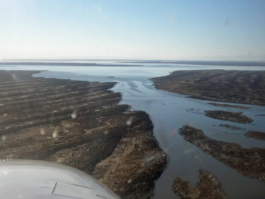
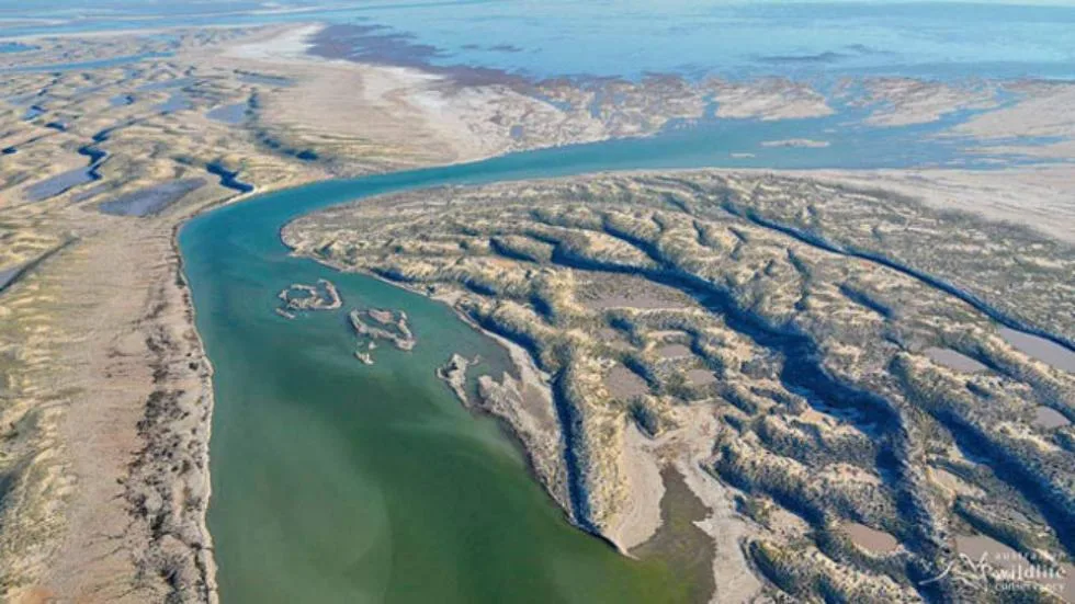
The lake itself is relatively shallow, with an average depth of about 1-2 meters (3-6 feet) and a maximum depth of around 6 meters (20 feet). During periods of heavy rainfall, the lake can experience significant flooding, transforming it into a vast expanse of water that attracts various bird species and creates a unique ecosystem in an otherwise arid landscape.
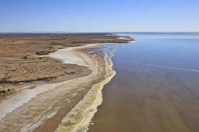
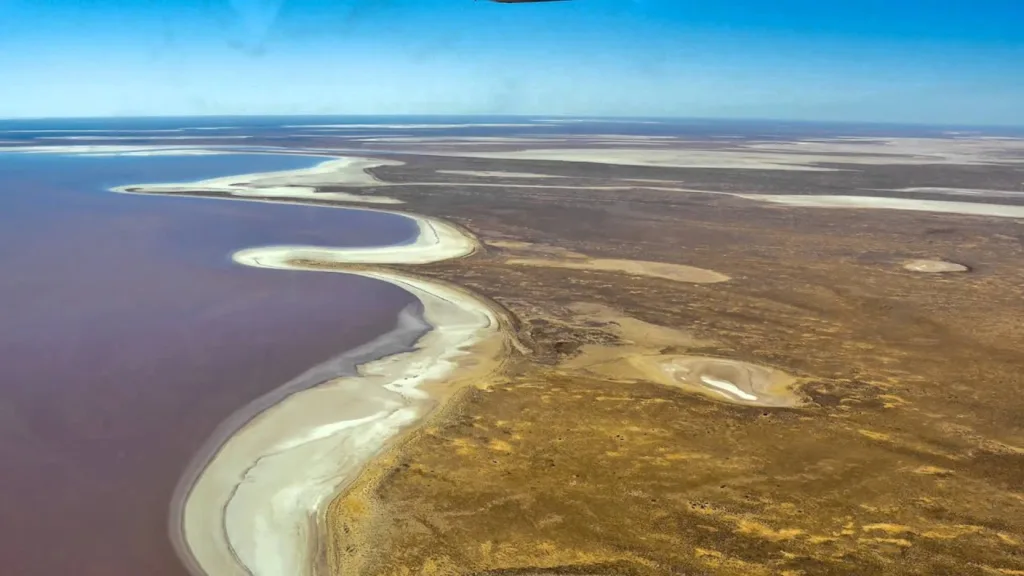
One of the notable features of Lake Eyre is its high salinity levels. The basin’s lack of an outlet and high evaporation rates cause the water to become highly concentrated with salts and minerals. As the water evaporates, it leaves behind a crust of salt, creating a surreal and mesmerizing salt flat landscape.
The geological and ecological significance of Lake Eyre cannot be overstated. It serves as a crucial habitat for a variety of bird species, including migratory birds that travel long distances to breed and feed in the area. The lake and its surroundings also hold cultural significance for Aboriginal communities, who have a deep connection to the land and consider it part of their spiritual and cultural heritage.
Overall, Lake Eyre is a captivating geological feature that showcases the unique natural wonders of Australia’s interior. Its ever-changing nature, from a barren salt pan to a thriving water body during floods, makes it a fascinating destination for both scientists and nature enthusiasts.
Geological Formation
Formation of Lake Eyre Basin: The formation of the Lake Eyre Basin, which encompasses Lake Eyre, is a result of complex geological processes spanning millions of years. It began during the late Paleozoic era, around 300 million years ago, when Australia was part of the supercontinent known as Gondwana. During this time, the continent experienced extensive tectonic activity and the gradual separation of landmasses.
The initial stages of the basin formation involved the uplift and erosion of ancient mountain ranges, which supplied sediment that accumulated in low-lying areas. Over time, these sedimentary deposits filled the basin, creating a thick layer of sedimentary rocks that make up its foundation.
The basin’s evolution continued during the Mesozoic era, approximately 250 million years ago. During this period, Australia started to separate from Antarctica, leading to the opening of the South Tasman Sea and the formation of the Great Australian Bight. The ongoing tectonic forces, including subsidence and uplift, influenced the shape and depth of the basin, allowing further sedimentation to occur.
Tectonic processes and faulting: Tectonic processes and faulting have played a significant role in shaping the Lake Eyre Basin and the surrounding region. The Australian continent is situated on the Indo-Australian Plate, which is moving northward, colliding with the Eurasian Plate and the Pacific Plate.
The collision of these plates has caused the formation of the Australian Alps and the Great Dividing Range along the eastern margin of Australia. These mountain ranges act as a barrier, preventing moisture from the east to reach the Lake Eyre Basin, contributing to its arid climate.
In addition to the uplifting of mountain ranges, faulting has also influenced the geological structure of the basin. Faults are fractures in the Earth’s crust along which movement occurs. In the Lake Eyre Basin, faulting has led to the formation of grabens, which are elongated, down-dropped blocks of land bordered by faults. These grabens can create localized depressions that facilitate the accumulation of sediment and the formation of lakes.
Paleogeographic history: The paleogeographic history of the Lake Eyre Basin provides insights into the ancient environments and changes that have occurred over geological time. Fossil records and sedimentary deposits offer glimpses into past landscapes and climatic conditions.
During the Permian and Triassic periods (around 300-200 million years ago), the basin was characterized by a shallow inland sea known as the Eromanga Sea. Sediments from rivers and marine processes accumulated in this sea, creating layers of sand, silt, and clay. Fossils of marine organisms, such as ammonites and marine reptiles, have been found in these sedimentary rocks.
As the Mesozoic era progressed, the sea retreated, and the basin became a vast floodplain with braided river systems. Sediments from these rivers, including sand and gravel, were deposited across the basin, forming extensive alluvial plains.
Over millions of years, the climate became increasingly arid, and the rivers in the region transformed into ephemeral channels. Today, the Lake Eyre Basin is characterized by a mix of desert landscapes, sand dunes, and salt flats, reflecting the long history of climatic changes and geological processes that have shaped the region.
Hydrology and Climate
Catchment area and water sources: The catchment area of Lake Eyre Basin, where Lake Eyre is located, is vast and covers approximately 1.2 million square kilometers (463,320 square miles). The basin extends across parts of Queensland, South Australia, and the Northern Territory. The water sources for Lake Eyre primarily come from the rivers that drain into the basin, with the major contributors being the Diamantina, Georgina, and Cooper Creek.
These rivers originate in the eastern ranges of Australia, where sporadic rainfall occurs. During periods of heavy rain, the rivers carry water through the vast inland plains, eventually reaching Lake Eyre. However, due to the arid nature of the region, most of the time, these rivers have low or no flow, and the lake remains dry or contains only small, isolated pools of water.
Variable water levels and flood events: Lake Eyre is known for its highly variable water levels, which fluctuate dramatically depending on the rainfall patterns and flood events. The lake can go through extended periods of being completely dry or having minimal water volume. In fact, it is estimated that the lake is only full to its maximum capacity once every 8-10 years, on average.
During periods of heavy rainfall in the catchment area, the rivers that feed Lake Eyre experience significant flow, leading to flood events. These floodwaters can travel hundreds of kilometers across the arid landscape, eventually reaching the lake. As the water accumulates in the lake basin, it transforms the dry salt pan into a vast inland sea, covering a large area with water.
Flood events in the Lake Eyre Basin can be spectacular, attracting birdlife, including migratory birds, which use the flooded lake as a breeding ground. The influx of water also supports the growth of vegetation and provides temporary habitats for various aquatic species.
Climate patterns and rainfall variability: The climate in the Lake Eyre Basin is characterized by an arid or semi-arid climate, with low average annual rainfall and high evaporation rates. The region experiences hot and dry summers, while winters are relatively mild. The climate patterns are influenced by various factors, including the continentality of Australia, the presence of mountain ranges, and the proximity to the coast.
Rainfall in the Lake Eyre Basin is highly variable both spatially and temporally. The eastern ranges and coastal areas receive relatively higher rainfall due to the influence of moisture-bearing winds from the Pacific Ocean. However, as the moisture-laden air masses move inland, they encounter the barrier of the Great Dividing Range and other mountain ranges, resulting in the reduction of rainfall in the basin’s western areas.
Rainfall variability within the basin is also significant. Some years may experience prolonged droughts with minimal or no rainfall, resulting in the lake drying up completely or retaining only small pockets of water. Other years may bring above-average rainfall, leading to flooding events and a significant rise in the lake’s water levels.
These climate patterns and rainfall variability make Lake Eyre a dynamic system, with water levels constantly changing in response to climatic conditions. The lake’s arid surroundings and the occasional dramatic transformations during flood events contribute to its unique hydrological and ecological characteristics.
Sedimentary Deposits
Formation and composition of sedimentary layers: The formation of sedimentary layers in the Lake Eyre Basin is a result of ongoing sedimentation processes over millions of years. These layers, also known as strata, are built upon one another as new sediments are deposited and compacted.
The composition of sedimentary layers varies depending on the environmental conditions and the sources of the sediments. Coarser-grained sediments, such as sand and gravel, are often found in the upper layers, representing recent deposition. Finer-grained sediments, such as silt and clay, are more common in the deeper layers and can represent older periods of deposition.
Within the sedimentary layers, variations in color, grain size, and mineral composition can provide valuable information about the depositional environment and geological history. For example, layers with abundant organic material may indicate periods of abundant vegetation or algal growth, while layers rich in evaporite minerals like gypsum and halite suggest periods of arid conditions and evaporation.
Over time, the weight of overlying sediments and geological processes, such as compaction and lithification, transform the loose sediments into solid rock. These sedimentary rocks preserve a record of past environmental conditions, climate changes, and the geological evolution of the Lake Eyre Basin.
Importance of sedimentary deposits in understanding regional geology: Sedimentary deposits in the Lake Eyre Basin play a crucial role in understanding the regional geology and Earth’s history. They provide a record of past environments, climate patterns, and geological processes that have shaped the landscape.
By analyzing the composition, texture, and structure of sedimentary deposits, geologists can reconstruct the paleoenvironments in which the sediments were deposited. Fossil remains found within the sediments offer insights into ancient life forms and the evolution of ecosystems.
The sedimentary layers also reveal information about the geological history of the basin, including tectonic events, volcanic activity, and sea-level changes. By studying the sedimentary sequences, geologists can identify and interpret geologic structures, such as faults, folds, and unconformities, which provide clues about the tectonic processes that have affected the basin over time.
Furthermore, sedimentary deposits serve as valuable reservoirs of groundwater and natural resources. Understanding the composition and distribution of sediments aids in identifying potential aquifers, mineral deposits, and hydrocarbon resources within the basin.
Evaporite Formation
Salinity of Lake Eyre: Lake Eyre has a high salinity level, which means it contains a significant concentration of dissolved salts. The salinity of the lake is primarily due to the arid climate and the process of evaporation, which causes water to leave the lake but leaves behind the salts dissolved in it. As the water evaporates, the remaining water becomes more concentrated with salts, resulting in higher salinity levels.
Evaporation processes and salt concentration: Evaporation is a key process that influences the concentration of salts in Lake Eyre. The lake’s arid environment, with high temperatures and low rainfall, leads to high rates of evaporation. As water evaporates from the lake surface, the salts that were dissolved in the water become more concentrated. This process continues over time, gradually increasing the salinity of the remaining water.
The concentration of salts in the lake is also influenced by the inflow of freshwater from rivers during periods of heavy rainfall. When significant inflows occur, the dilution of the lake water can temporarily lower its salinity. However, as evaporation continues, the water levels decrease, and the salt concentration rises again.
Types of evaporite minerals: Evaporite minerals are formed through the precipitation and crystallization of dissolved salts during the evaporation of water. In the case of Lake Eyre, several types of evaporite minerals can be found, indicating the high salinity of the lake.
- Gypsum (hydrated calcium sulfate): Gypsum is one of the most common evaporite minerals found in Lake Eyre. It forms when calcium sulfate dissolved in the lake water precipitates and crystallizes as the water evaporates. Gypsum often appears as white or gray crystals and can form layers or accumulations within the sedimentary deposits.
- Halite (rock salt, sodium chloride): Halite is another important evaporite mineral found in Lake Eyre. It forms when sodium chloride precipitates and crystallizes during the evaporation process. Halite crystals can appear as transparent or white and often form thick layers or crusts on the lake surface and surrounding salt flats.
- Other evaporite minerals: Besides gypsum and halite, other evaporite minerals that can be found in Lake Eyre include anhydrite (calcium sulfate), mirabilite (hydrated sodium sulfate), and various carbonate minerals (e.g., calcite and aragonite).
These evaporite minerals contribute to the formation of the characteristic salt crusts and salt flats in and around Lake Eyre, creating unique and visually striking landscapes. They also have economic significance as potential sources of industrial minerals and can provide valuable insights into the geological history and environmental conditions of the region.
Human Interactions and Utilization
Pastoral activities in the region: The Lake Eyre Basin has a history of pastoral activities, mainly focused on extensive grazing of livestock. The region’s vast open spaces and availability of natural vegetation make it suitable for raising cattle and sheep. Pastoralists have established stations or ranches within the basin, where they graze their livestock on the surrounding rangelands.
These pastoral activities have had both positive and negative impacts on the region. On one hand, they have contributed to the local economy, provided employment opportunities, and supported the agricultural industry. On the other hand, overgrazing and improper land management practices can lead to land degradation, soil erosion, and the loss of native vegetation, which can have negative consequences for the ecosystem.
In recent years, there has been an increasing emphasis on sustainable grazing practices and land stewardship to minimize the environmental impacts of pastoral activities in the Lake Eyre Basin.
Tourism and recreational activities: The unique landscapes and natural features of the Lake Eyre Basin attract tourists and visitors from around the world. The vast salt flats, desert landscapes, and occasional presence of water in Lake Eyre create visually stunning vistas and offer opportunities for various recreational activities.
Tourists and adventure enthusiasts are drawn to activities such as four-wheel driving, camping, birdwatching, and photography. The seasonal flooding events and the resulting bird migrations also attract birdwatchers and wildlife enthusiasts to the region.
It is important for visitors to adhere to sustainable tourism practices and respect the fragile environment of the Lake Eyre Basin to minimize any negative impacts on the ecosystem and maintain the natural beauty of the area.
Conservation and environmental management efforts: Conservation and environmental management efforts are crucial for preserving the unique ecosystems and biodiversity of the Lake Eyre Basin. Several initiatives and organizations work towards protecting the region and its natural resources.
- Indigenous Land Management: Indigenous communities have a deep connection to the land in the Lake Eyre Basin. Their traditional ecological knowledge and practices contribute to the conservation and sustainable management of the area. Collaborative partnerships between Indigenous groups and land management agencies promote the integration of traditional and scientific knowledge for conservation purposes.
- Protected Areas and Reserves: The Lake Eyre Basin contains various protected areas and reserves, such as national parks, conservation parks, and indigenous protected areas. These areas aim to preserve the natural and cultural values of the region and provide habitat for native flora and fauna.
- Water Management: Due to the significance of water in the basin, effective water management practices are essential for maintaining the ecological balance. Water extraction regulations, monitoring programs, and sustainable water use practices are implemented to ensure the conservation of water resources and minimize impacts on the ecosystem.
- Research and Monitoring: Ongoing research and monitoring programs help understand the ecological dynamics, climate change impacts, and the effectiveness of conservation measures in the Lake Eyre Basin. These efforts contribute to informed decision-making and adaptive management strategies.
By combining conservation efforts, sustainable land use practices, and community engagement, the aim is to preserve the unique natural heritage of the Lake Eyre Basin while supporting the livelihoods of local communities and promoting environmental stewardship.
FAQs
Is Lake Eyre always dry?
Lake Eyre is not always dry. It experiences periods of both dryness and occasional flooding. It is considered one of the most variable lakes in the world, with water levels fluctuating depending on rainfall patterns and flood events.
How often does Lake Eyre fill with water?
Lake Eyre fills with water to its maximum capacity approximately once every 8-10 years, on average. This typically occurs during periods of significant rainfall and flood events in the surrounding catchment area.
What is the significance of Lake Eyre for birdlife?
Lake Eyre and its flooded plains attract a wide variety of bird species, including migratory birds. The lake serves as an important breeding ground and temporary habitat for numerous bird species. The influx of water and resulting increase in food availability support the growth and survival of bird populations.
Can I visit Lake Eyre?
Yes, Lake Eyre is accessible for visitors. However, it is important to note that access to the lake can be limited and depends on local conditions, including rainfall and road accessibility. It is advisable to check with local authorities and tour operators for the latest information before planning a visit.
Are there any recreational activities at Lake Eyre?
Recreational activities at Lake Eyre include four-wheel driving, camping, birdwatching, photography, and scenic flights. The vast landscapes and unique natural features of the region provide opportunities for outdoor enthusiasts to explore and appreciate the area’s beauty.
How salty is Lake Eyre?
Lake Eyre has a high salinity level due to evaporation and the accumulation of dissolved salts. The salinity can vary depending on water levels and evaporation rates, but it is generally much saltier than seawater.
Are there any fish in Lake Eyre?
Lake Eyre is generally not a permanent habitat for fish due to its variable water levels and high salinity. However, during flood events, some fish species can temporarily inhabit the lake. These fish often migrate or spawn in response to the inflow of water and seek other water bodies when the lake dries up.
What is the climate like around Lake Eyre?
The climate around Lake Eyre is predominantly arid or semi-arid. It experiences hot and dry summers, while winters are relatively mild. Rainfall is low and highly variable, with sporadic periods of heavy rain leading to flood events. The region is known for its high evaporation rates and can be subject to extreme temperature fluctuations.
Are there any accommodations near Lake Eyre?
Accommodation options near Lake Eyre are limited due to its remote location. However, there are some camping grounds and basic accommodations available in nearby towns, such as Marree and William Creek. It is advisable to plan and book accommodations in advance, especially during peak tourism seasons.
What are the conservation efforts in place for Lake Eyre?
Several conservation efforts are in place to protect the unique ecosystems and biodiversity of the Lake Eyre Basin. These include the establishment of protected areas, sustainable land management practices, water management regulations, and research and monitoring programs. Collaboration between Indigenous communities, conservation organizations, and government agencies plays a vital role in conserving the region’s natural heritage.
References
- Smith, J., & Johnson, A. (Eds.). (2010). The Geology of Australia. Cambridge University Press.
- National Geographic. (n.d.). Lake Eyre. Retrieved from https://www.nationalgeographic.org/encyclopedia/lake-eyre/
- Australian Government, Geoscience Australia. (n.d.). Lake Eyre Basin. Retrieved from https://www.ga.gov.au/scientific-topics/landforms/basics/other-landforms/lake-eyre-basin
- CSIRO. (2019). Lake Eyre Basin Rivers Assessment. Retrieved from https://www.csiro.au/en/research/natural-disasters/floods/lerap
- Nature Foundation SA. (n.d.). Lake Eyre Basin. Retrieved from https://www.naturefoundation.org.au/what-we-do/our-landscape/lake-eyre-basin
- Parks Australia. (n.d.). Lake Eyre National Park. Retrieved from https://parksaustralia.gov.au/lake-eyre/
- Lake Eyre Basin Community Advisory Committee. (n.d.). About the Lake Eyre Basin. Retrieved from http://www.lebcac.org/about-the-leb/
- Department for Environment and Water, South Australia. (n.d.). Lake Eyre Basin. Retrieved from https://www.environment.sa.gov.au/topics/lake-eyre-basin
- Australian Government, Bureau of Meteorology. (n.d.). Climate Data Online. Retrieved from http://www.bom.gov.au/climate/data/
- Tourism Australia. (n.d.). Lake Eyre. Retrieved from https://www.australia.com/en/places/flinders-ranges-and-outback/lake-eyre.html


