


")


Lake Powell is one of the largest man-made reservoirs in the United States, located primarily in southern Utah and northern Arizona. Created by the construction of the Glen Canyon Dam on the Colorado River, the lake stretches for approximately 186 miles (299 km) and has over 2,000 miles (3,200 km) of shoreline, making it a premier destination for water-based recreation and a scenic gem of the American Southwest.
Named after John Wesley Powell, the 19th-century explorer who led the first expedition down the Colorado River, Lake Powell offers visitors a rare combination of awe-inspiring geological formations, deep blue waters, and a diverse array of ecosystems. It is set within the Glen Canyon National Recreation Area, managed by the National Park Service, and draws millions of visitors each year for boating, fishing, camping, and sightseeing.
Geological Significance and Formation

The story of Lake Powell’s creation begins not with the dam itself, but with the ancient geological forces that shaped the surrounding landscape over hundreds of millions of years. The lake sits within Glen Canyon, which is part of the greater Colorado Plateau. This plateau, a massive uplifted region of sedimentary rock, was shaped by tectonic forces and erosion, creating the dramatic canyons, mesas, and cliffs seen today.
Rock Layers and Geological History
Lake Powell’s surroundings are dominated by sedimentary rock layers that were deposited over 300 million years ago during different geological periods, primarily the Paleozoic, Mesozoic, and early Cenozoic eras. The most prominent formations visible around the lake include the Navajo Sandstone, the Kayenta Formation, and the Wingate Sandstone. Each of these layers tells a story of ancient environments that once existed in this region:
- Navajo Sandstone: This is one of the most visually striking formations around Lake Powell, known for its smooth, rounded cliffs and reddish-orange color. Formed around 190 million years ago during the Jurassic period, this sandstone is composed of ancient sand dunes that were cemented together by mineral-rich water. The Navajo Sandstone represents a vast desert that once covered much of what is now the southwestern United States.
- Kayenta Formation: This layer, which is older than the Navajo Sandstone, was deposited in a river-dominated environment approximately 195 million years ago. The Kayenta Formation often appears as reddish-brown cliffs and ledges and can be seen beneath the Navajo Sandstone. It represents the ancient rivers and floodplains that once crisscrossed the region.
- Wingate Sandstone: Beneath the Kayenta Formation lies the Wingate Sandstone, another layer of ancient desert dunes, formed around 200 million years ago during the late Triassic period. The Wingate is harder and more resistant to erosion, which is why it often forms tall, sheer cliffs along the lake’s shores.
These rock formations were deposited in layers over millions of years, but it was the uplifting of the Colorado Plateau during the late Cenozoic era (roughly 5-10 million years ago) that set the stage for the dramatic erosion that created the canyons, valleys, and cliffs we see today. As the Colorado River carved through these layers, it exposed the geologic history of the region, revealing sedimentary sequences that provide valuable insights into Earth’s ancient past.
Glen Canyon Formation and the Colorado River
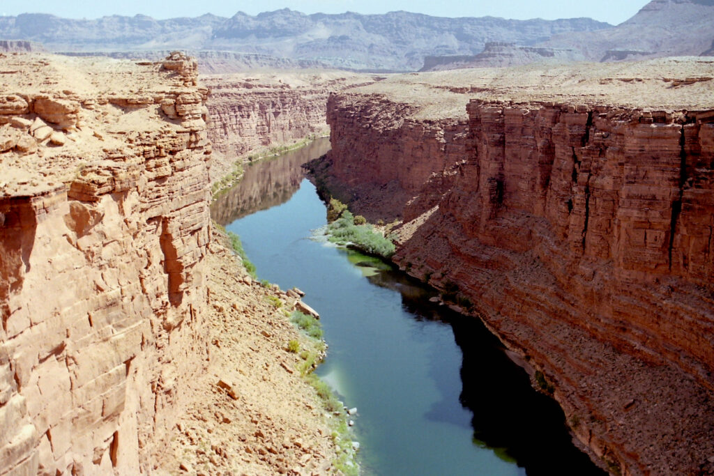
Glen Canyon, where Lake Powell now resides, was carved by the relentless erosive power of the Colorado River over the past few million years. As the river cut through the plateau, it created the steep canyon walls that make Glen Canyon so visually striking. The process of downcutting (river erosion) was accelerated by the uplift of the Colorado Plateau, which gave the river more energy as it descended from higher elevations.
Before the creation of Lake Powell, Glen Canyon was renowned for its remote beauty—an unspoiled wilderness of towering red cliffs, deep narrow side canyons, and a winding, powerful river. When Glen Canyon Dam was completed in 1963, the rising waters of the Colorado River submerged much of this landscape, transforming Glen Canyon into the vast reservoir known as Lake Powell.
Glen Canyon Dam: Engineering and Environmental Impact
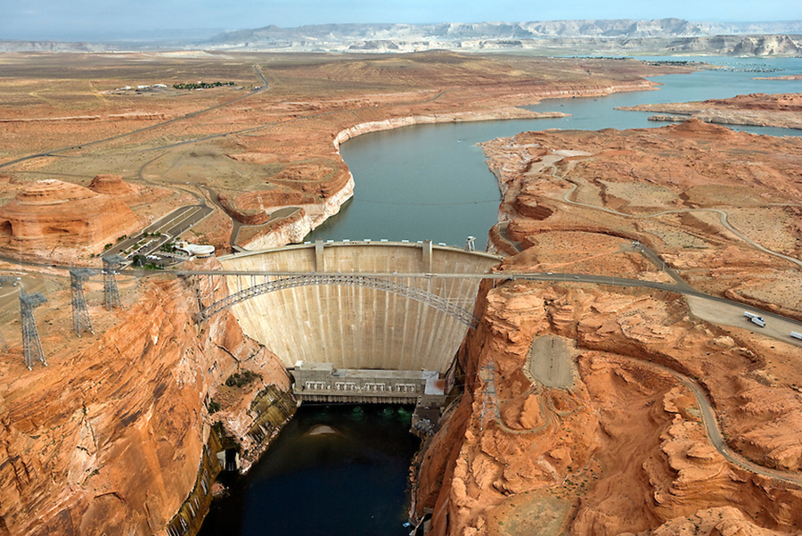
The construction of Glen Canyon Dam, which took place between 1956 and 1963, was a monumental feat of engineering. Standing 710 feet (216 meters) high, the dam was built to regulate the flow of the Colorado River, provide hydroelectric power, and ensure a reliable water supply for the arid southwestern United States. It created Lake Powell by impounding the river’s flow, filling the once-dry canyon with water.
While the dam has provided important benefits, including water storage and flood control, it has also sparked controversy due to its environmental impact. The flooding of Glen Canyon submerged many of its unique geological and archaeological features, leading to a long-standing debate between conservationists and proponents of water management.
The creation of Lake Powell also altered the natural flow of the Colorado River, affecting ecosystems both upstream and downstream. Downstream of the dam, the reduced sediment load has changed the river’s ecology, impacting fish species and vegetation. However, Lake Powell has also become a crucial water source for millions of people in Arizona, California, Nevada, and Utah.
Geological Features of Lake Powell
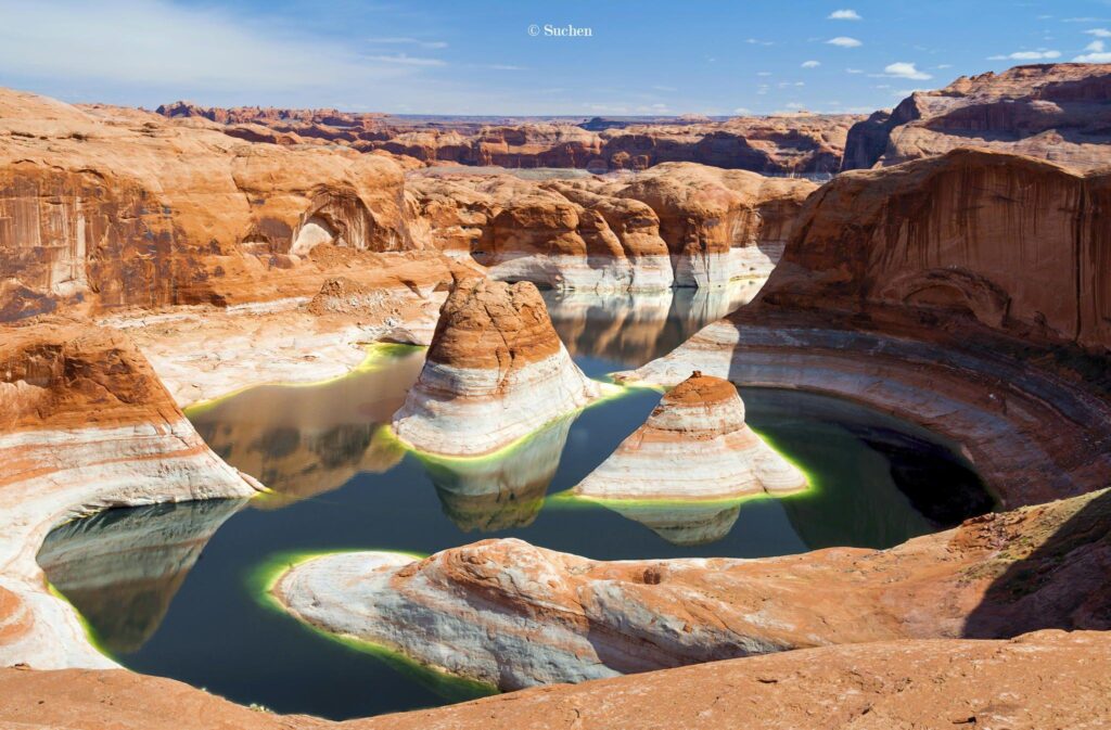
Although much of Glen Canyon is now underwater, Lake Powell’s shoreline and surrounding landscape remain geologically fascinating. The lake is punctuated by numerous rock formations, including towering cliffs, narrow slot canyons, and impressive buttes that rise from the water.
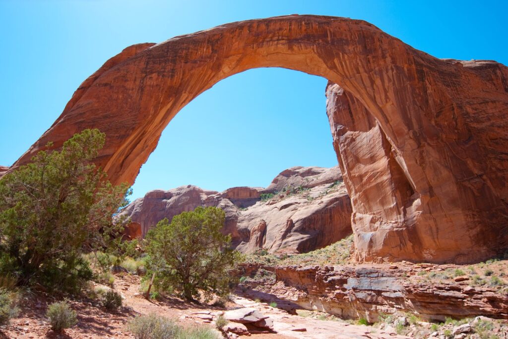
Rainbow Bridge: One of the most famous geological landmarks near Lake Powell is Rainbow Bridge, one of the largest natural bridges in the world. This massive arch was formed by the forces of erosion, as water gradually wore away the rock. Spanning 275 feet (84 meters) and standing 290 feet (88 meters) tall, Rainbow Bridge is considered sacred by several Native American tribes and is a popular attraction for boaters and hikers.
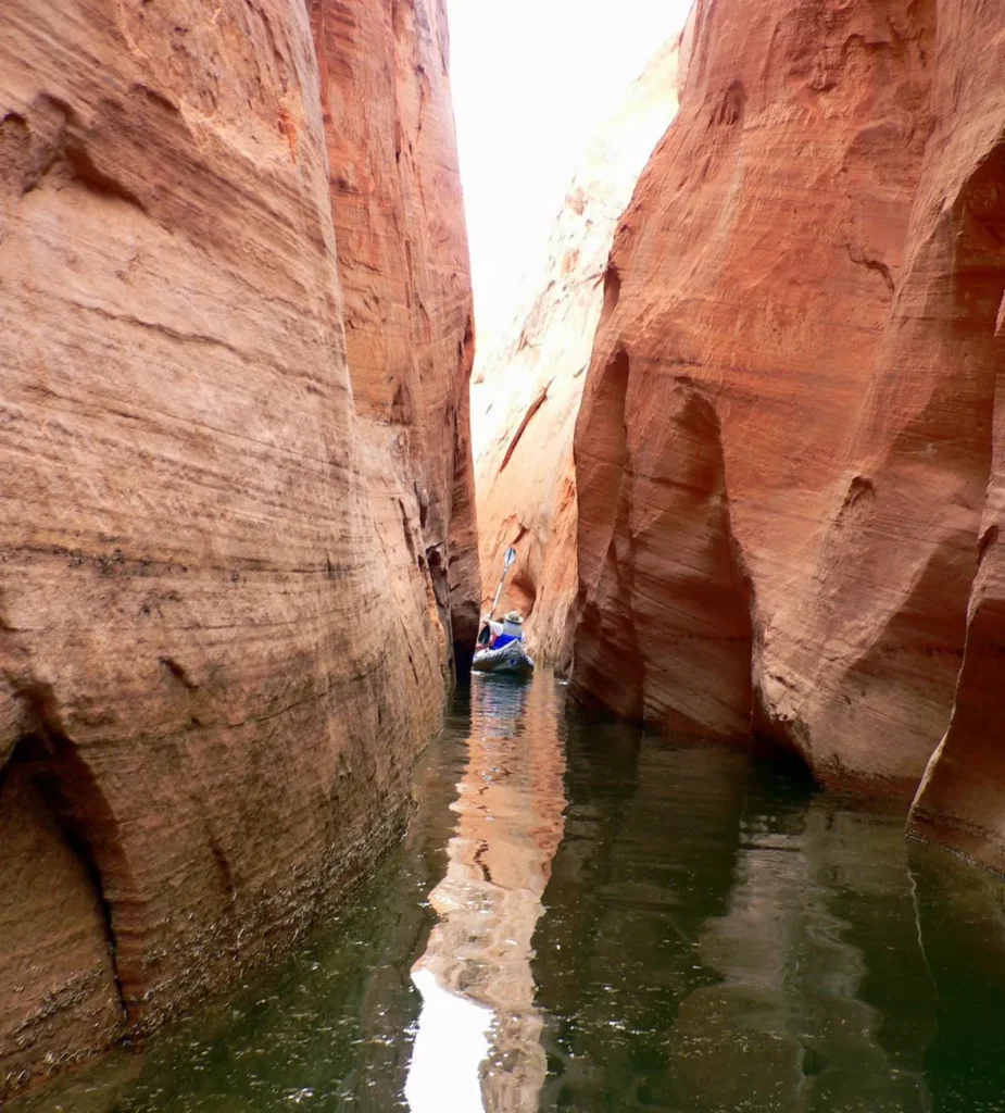
Slot Canyons: Many of the side canyons around Lake Powell are narrow, winding slot canyons formed by the erosion of softer rock layers. These canyons, which often feature sheer walls and smooth, curving shapes, are popular for hiking, kayaking, and photography. The most famous of these is Antelope Canyon, located just east of the lake. It is celebrated for its wave-like rock formations and light beams that shine through the narrow openings above.
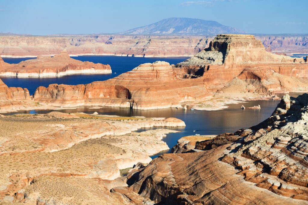
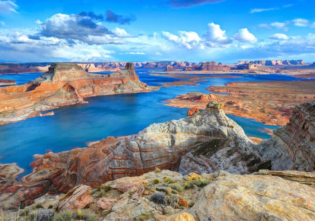
Buttes and Mesas: Rising from the waters of Lake Powell are several large rock formations known as buttes and mesas. These flat-topped, steep-sided formations were left behind as the surrounding softer rock was eroded away. Examples include Alstrom Point and Gunsight Butte, both of which offer stunning viewpoints over the lake and surrounding landscape.
Submerged Canyon Walls: Beneath the surface of Lake Powell, the original walls of Glen Canyon remain intact, though now submerged by water. In periods of low water levels, parts of the canyon walls and old river channels become visible again, offering a glimpse of the pre-dam landscape. The reservoir’s fluctuating water levels, driven by seasonal changes and long-term drought conditions, reveal the submerged geological features in different ways.
Ecological and Environmental Considerations
Lake Powell’s ecosystem is a blend of desert and aquatic environments, supporting a variety of plant and animal species. The lake itself is home to several fish species, including largemouth bass, striped bass, and catfish, making it a popular destination for anglers. Around the lake, the desert landscape supports a range of wildlife, from desert bighorn sheep to coyotes and migratory birds.
However, the creation of Lake Powell has also had significant environmental impacts. The damming of the Colorado River has altered the natural sediment flow, affecting habitats downstream. In addition, the introduction of non-native fish species has had an impact on the native aquatic ecosystems.
Water levels in Lake Powell have been a topic of increasing concern in recent years due to prolonged drought and the effects of climate change. The lake has experienced record low water levels, which not only affect water supplies and hydroelectric power generation but also reveal submerged geological features and archaeological sites that have been hidden for decades.
Recreational Opportunities and Tourism
Despite the environmental concerns, Lake Powell remains a popular destination for recreation. Its vast size and intricate network of bays and canyons make it a boater’s paradise. Visitors can explore the lake by houseboat, speedboat, kayak, or paddleboard, with ample opportunities for swimming, fishing, and water sports. The Glen Canyon National Recreation Area offers numerous campsites, hiking trails, and viewpoints.
Popular activities include:
- Boating and Houseboating: Lake Powell is famous for its houseboats, which allow visitors to explore the lake at a leisurely pace and find secluded spots for swimming and fishing.
- Fishing: The lake is stocked with a variety of fish species, making it a great destination for anglers.
- Hiking: Visitors can hike along the lake’s shores and explore the numerous side canyons, with trails leading to stunning overlooks and geological formations like Rainbow Bridge.
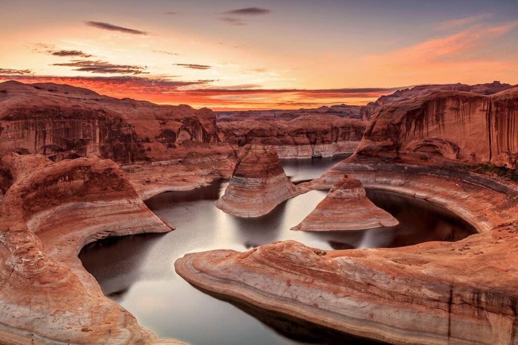
- Photography: The contrast between the deep blue waters of Lake Powell and the red rock cliffs makes for spectacular photography, particularly during sunrise and sunset.
Conclusion
Lake Powell is not only a recreational hub but also a geological wonder, offering a window into the ancient history of the Colorado Plateau. From its towering sandstone cliffs and submerged canyons to the forces that shaped the landscape over millions of years, the lake represents a unique intersection of natural beauty and human engineering. As climate change and environmental challenges continue to affect the region, the future of Lake Powell remains uncertain, making the preservation and appreciation of its geological and cultural significance all the more important


 Ore")