










When an earthquake is reported, one of the first locations mentioned is usually the epicenter. It appears as a point on a map and is often described as the place where the earthquake occurred.
But an earthquake does not actually begin at the epicenter.
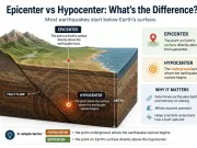
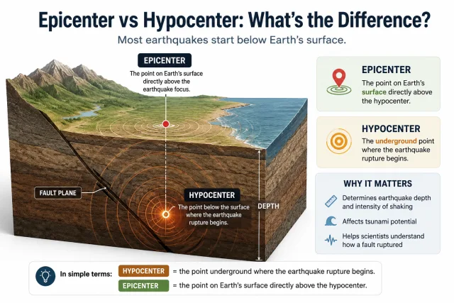
The rupture starts underground at a point called the hypocenter, also known as the earthquake focus. The epicenter is simply the point on Earth’s surface directly above that underground starting point.
In the simplest terms:
Hypocenter = where the earthquake rupture begins below the surface.
Epicenter = the point on the surface directly above the hypocenter.
The distinction is important because the depth and location of the hypocenter help scientists understand how an earthquake occurred, while the epicenter provides a convenient geographic reference on maps.
What Is the Hypocenter of an Earthquake?
The hypocenter is the point beneath Earth’s surface where fault rupture begins.
Stress can build along a fault for years, decades, or much longer. When the stress exceeds the strength of the rocks, part of the fault suddenly slips.
The first point where that rupture begins is the hypocenter.
Stored elastic energy is then released and travels outward as seismic waves, including P-waves, S-waves, and surface waves.
The term focus is also commonly used for the same location.
So:
hypocenter = earthquake focus
However, the hypocenter should not be confused with the entire earthquake rupture.
A major earthquake may begin at one point and then rupture tens or even hundreds of kilometers of a fault. The hypocenter marks only the starting point of that larger rupture.
What Is the Epicenter of an Earthquake?
The epicenter is the point on Earth’s surface directly above the hypocenter.
Imagine drawing a vertical line upward from the underground point where the earthquake begins. Where that line reaches the surface is the epicenter.
For example, if an earthquake starts 18 kilometers underground, its hypocenter is at a depth of 18 kilometers. The geographic point directly above it is the epicenter.
This is why earthquake reports often say things such as:
The epicenter was 25 kilometers east of a city.
The epicenter is easier to represent on a map than the three-dimensional position of the hypocenter.
But it is important to remember that the epicenter is a surface reference point, not the underground location where the fault rupture actually starts.
Epicenter vs Hypocenter: Key Differences
| Feature | Epicenter | Hypocenter |
|---|---|---|
| Location | Earth’s surface | Below Earth’s surface |
| Meaning | Point directly above the hypocenter | Point where rupture begins |
| Other name | Surface reference point | Earthquake focus |
| Includes depth? | No | Yes |
| Commonly shown on maps? | Yes | Usually shown in cross-sections or 3D models |
| Relationship | Directly above hypocenter | Directly beneath epicenter |
| Represents entire rupture? | No | No, only the rupture starting point |
The difference is therefore mainly one of depth and position.
The hypocenter exists inside Earth.
The epicenter is its surface projection.
How Deep Can an Earthquake Hypocenter Be?
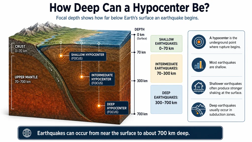
The distance between the hypocenter and Earth’s surface is called focal depth.
Earthquakes occur at very different depths, but they are commonly divided into three broad groups.
Shallow Earthquakes
Shallow-focus earthquakes occur at depths of about 0–70 kilometers.
Most earthquakes worldwide are shallow.
Many destructive earthquakes along continental faults also fall into this category because the rupture occurs relatively close to the surface.
Intermediate-Depth Earthquakes
Intermediate earthquakes occur at depths of roughly 70–300 kilometers.
They are especially associated with subduction zones, where one tectonic plate sinks beneath another.
Earthquakes can continue to occur within the descending plate as it moves deeper into the mantle.
Deep Earthquakes
Deep-focus earthquakes occur at approximately 300–700 kilometers depth.
They are mainly found inside deeply subducting slabs.
Earthquakes become extremely rare below about 700 kilometers because the high temperatures and pressures at greater depths make ordinary brittle failure increasingly difficult.
Why Does Earthquake Depth Matter?
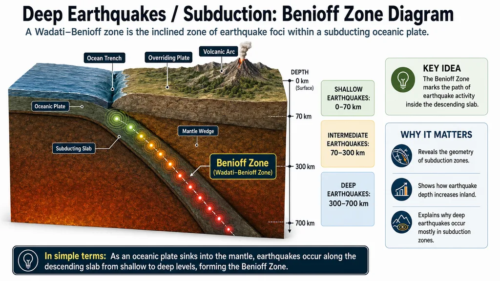
Benioff Zone diagram showing shallow, intermediate, and deep earthquakes along a subducting oceanic plate beneath an overriding plateFocal depth can strongly influence how an earthquake is experienced at the surface.
A shallow earthquake releases energy relatively close to towns, roads, and buildings. Seismic waves therefore travel a shorter distance before reaching the surface.
This can contribute to intense shaking near the rupture.
A deeper earthquake may be felt across a much larger region, but the shaking near the surface can sometimes be weaker than that from a similar-magnitude shallow earthquake.
However, depth is only one part of the story.
Earthquake damage also depends on:
- magnitude,
- distance from the ruptured fault,
- fault mechanism,
- rupture direction,
- local geology,
- soil conditions,
- building design and construction quality.
This is why two earthquakes with similar magnitudes can produce very different levels of damage.
Is the Epicenter Always Where the Strongest Shaking Occurs?
No.
This is one of the most common misconceptions about earthquakes.
The epicenter is simply the surface point directly above the hypocenter. It does not automatically mark the location of the strongest ground motion or greatest damage.
Large earthquakes can rupture very long sections of faults.
Suppose an earthquake begins at one end of a fault and then rupture travels 120 kilometers along it. A city 60 kilometers from the epicenter may actually lie much closer to another part of the ruptured fault.
That city could experience stronger shaking than a location directly at the epicenter.
Other factors can also change the pattern of shaking.
Rupture Directivity
A fault rupture can propagate preferentially in one direction, concentrating seismic energy toward certain areas.
Local Geology
Soft sedimentary basins can amplify seismic waves, while nearby areas built on competent bedrock may experience less amplification.
Distance to the Fault
For large earthquakes, distance to the actual rupture surface can sometimes matter more than distance to the epicenter.
So:
Epicenter does not mean “the most dangerous point.”
It is primarily a geographic reference.
How Do Scientists Find an Earthquake’s Epicenter and Hypocenter?
Scientists locate earthquakes using networks of seismic stations.
When an earthquake begins, several types of seismic waves travel outward.
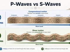
P-waves move faster and normally reach a seismic station first.
S-waves travel more slowly and arrive later.
The difference between their arrival times is known as the S–P interval.
The greater the separation between the P- and S-wave arrivals, the farther the station generally is from the earthquake source.
A single station can estimate distance, but it cannot determine the complete location by itself.
Data from multiple seismic stations are therefore combined.
Modern earthquake-location systems use:
- P-wave arrival times,
- S-wave arrival times,
- many seismic stations,
- seismic velocity models,
- computer-based inversion methods.
From these data, scientists estimate:
- latitude,
- longitude,
- focal depth,
- origin time.
The latitude and longitude define the epicenter.
Adding depth gives the full three-dimensional position of the hypocenter.
Why Does the Reported Epicenter or Depth Sometimes Change?
It is common for earthquake locations to be revised after the first report.
For example, an initial automatic solution may list:
Depth: 10 km
and later change to:
Depth: 16 km
The epicenter may also move by several kilometers.
This does not mean the earthquake itself moved.
The earliest earthquake solutions are often generated automatically using the seismic data available during the first minutes after the event.
As additional stations record the earthquake, scientists gain more information.
The solution can then be refined.
Another factor is the seismic velocity model.
Seismic waves do not travel at the same speed through every type of rock. Earth’s crust contains layers and structures with different physical properties.
Using a better model of those underground velocities can improve the estimated earthquake location.
Small revisions to an epicenter or hypocenter are therefore normal.
Does the Epicenter Identify the Fault That Ruptured?
Not necessarily.
If an epicenter lies close to a known active fault, that fault may be an obvious candidate.
But the epicenter alone is usually not enough to prove which fault moved, especially in regions where several faults are close together.
Scientists use additional evidence such as:
- aftershock distribution,
- focal mechanisms,
- surface rupture,
- GPS measurements,
- satellite deformation,
- seismic waveform analysis.
Aftershocks can be particularly useful.
If hundreds of aftershock hypocenters are plotted in three dimensions, their pattern can reveal the geometry of the fault that ruptured.
This can even expose faults that have little or no visible expression at the surface.
What Can Aftershock Hypocenters Tell Us?
After a large earthquake, smaller earthquakes often occur around the rupture zone.
These aftershocks do not appear randomly.
Their hypocenters can outline the underground fault structure.
When scientists plot them in three dimensions, they may reveal:
- the angle of the fault,
- the depth range of rupture,
- the length of the activated fault zone,
- nearby faults that were also stressed.
This is one reason hypocenter information is so valuable.
An epicenter provides a location on a map.
A collection of hypocenters can reveal the hidden geometry of an entire fault system beneath the surface.
Can an Epicenter Be in the Ocean?
Yes.
Many of Earth’s major plate boundaries lie beneath the oceans, so offshore earthquakes are extremely common.
Some of the world’s largest earthquakes occur along underwater subduction zones.
An offshore epicenter, however, does not automatically mean a tsunami will occur.
Tsunami generation depends on several factors, including:
- earthquake magnitude,
- focal depth,
- fault type,
- amount and direction of seafloor displacement.
Large, shallow earthquakes that produce significant vertical movement of the seafloor are the most important tsunami-generating events.
A deep earthquake or one involving mainly horizontal fault movement may produce little or no tsunami even if its epicenter is offshore.
Epicenter, Hypocenter and Fault: What’s the Difference?
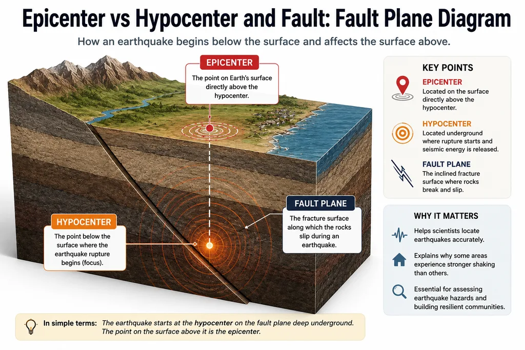
Fault plane diagram showing the hypocenter where earthquake rupture begins, the epicenter directly above it, and the inclined fault surface where rocks slipThese three terms describe different parts of the earthquake process.
Hypocenter:
The underground point where rupture begins.
Epicenter:
The surface point directly above the hypocenter.
Fault:
The fracture or fracture zone along which rock masses move.
A fault may extend for hundreds of kilometers.
The hypocenter is just one point on that fault where a particular earthquake begins.
After rupture starts, it can spread across a much larger section of the fault.
This is why a large earthquake cannot be understood simply by looking at its epicenter.
A Simple Example
Imagine an earthquake begins 12 kilometers below Earth’s surface.
The underground starting point is the:
Hypocenter
The point directly above it is the:
Epicenter
Now suppose the rupture spreads eastward along 80 kilometers of fault.
A city 40 kilometers from the epicenter happens to sit directly beside the ruptured fault and on thick, soft sediments.
Another town lies almost directly at the epicenter but is built on solid bedrock.
The city farther from the epicenter could experience stronger shaking and greater damage.
The example shows why earthquake effects depend on much more than the position of a single dot on a map.
Why Are Epicenter and Hypocenter Important?
The epicenter is useful because it gives the public and scientists an immediate geographic reference for an earthquake.
The hypocenter provides additional information that is essential for understanding the earthquake itself.
Its depth can help reveal the tectonic environment.
A cluster of hypocenters can show the shape of a hidden fault.
Changes in hypocenter distribution can reveal where aftershocks are occurring.
Together, epicenter and hypocenter information help scientists understand earthquakes in three dimensions rather than treating them as isolated points on a map.
Frequently Asked Questions
Is the hypocenter the same as the focus?
Yes. Hypocenter and earthquake focus generally mean the same thing: the point below Earth’s surface where the rupture begins.
Does an earthquake start at the epicenter?
No. It begins at the hypocenter underground. The epicenter is the point on the surface directly above it.
Is the epicenter always where earthquake damage is greatest?
No. Damage depends on the full fault rupture, distance, local geology, soil conditions, rupture direction, and the vulnerability of buildings.
How deep can an earthquake hypocenter be?
Most earthquakes are shallow, but earthquakes in subduction zones can occur hundreds of kilometers below the surface. The deepest earthquakes reach depths close to 700 kilometers.
Why can shallow earthquakes be more damaging?
Their rupture occurs closer to the surface, so strong seismic energy can reach nearby communities over a shorter distance. Magnitude, geology, distance to the fault, and building quality are also important.
Can an earthquake have more than one epicenter?
A standard earthquake location has one hypocenter and one corresponding epicenter. However, a large earthquake can rupture a very large fault area, so the epicenter does not represent the entire rupture.
Why does an earthquake’s epicenter sometimes change after the first report?
Early locations are often automatic estimates based on limited data. As more seismic records become available, the epicenter and focal depth can be refined.
Can an earthquake epicenter be underwater?
Yes. Many earthquakes occur beneath oceans, especially along mid-ocean ridges and subduction zones.
Final Thoughts
The difference between an epicenter and a hypocenter is simple but important.
The hypocenter is the underground point where an earthquake rupture begins.
The epicenter is the location on Earth’s surface directly above it.
But neither point represents the entire earthquake.
Large ruptures can spread across tens or hundreds of kilometers of fault, and the strongest shaking does not necessarily occur at the epicenter.
The hypocenter adds another crucial dimension: depth.
Knowing where a rupture begins beneath the surface helps scientists understand earthquake behavior, map hidden faults, interpret aftershock patterns, and identify the tectonic processes responsible.
So when an earthquake map shows a single dot labeled epicenter, that dot is only the surface reference.
The earthquake itself began somewhere below it.