


")


")


Earthquakes are one of the most powerful and destructive natural phenomena that occur on our planet. They can cause widespread devastation, loss of life, and economic damage, making them a significant threat to human societies. Throughout history, the earth has experienced many powerful earthquakes that have left a lasting impact on the affected regions. These seismic events can vary in magnitude, with the most severe earthquakes reaching levels that are hard to comprehend. In this article, we will explore the ten most powerful earthquakes ever recorded in Earth’s history, examining their causes, impacts, and the lessons learned from these catastrophic events. Understanding the power and impact of these earthquakes can help us prepare for and mitigate the damage caused by future seismic events.
10. The 2012 Indian Ocean earthquakes

11 April ,2012 at 15.38 local time, Indian Ocean earthquakes were magnitude 8.6 undersea that near of Indonesian city of Aceh. Authorities were at tsunami call but subsequently cancelled .These were unusually strong intraplate earthquakes and the largest strike-slip earthquake ever recorded.
it occurred very remote from an inhabited place and produced no destructive tsunami (10 cm to 0.8 meter / 3.9 inches to 31.4 inches tsunamis were reported). 10 deaths and 12 injuries were reported – most of them caused by panic and/or heart attack.
9. Assam-Tibet Earthquake (1950) – 8.6

On August 15, 1950, Earthquake occured at Xizang-India border region and epicenter of earthquake located near Rima,Tibet, Result of earthquakes many buildings were destroyed and between 1.500 and 3.000 peaple were killed.
After the earthquake, large landslides blocked the Subansiri River. This natural dam broke 8 days later, creating a wave of 7 m (23 ft) high which inundated several villages and killed 536 people.
The earthquake also created around 5,000,000 homeless.
8. Rat Islands Earthquake(1965) – 8.7
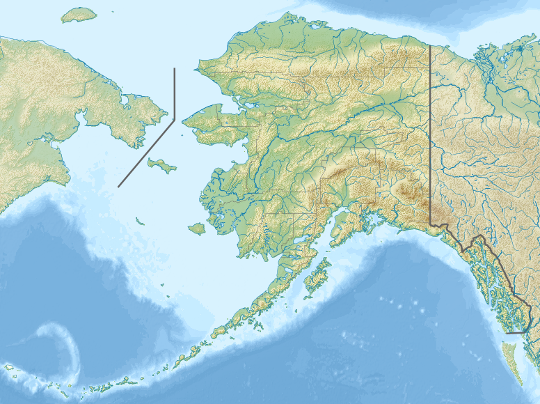
The Rat Islands earthquake of 1965 was a powerful earthquake that occurred on February 4, 1965, in the Rat Islands region of Alaska. The earthquake had a magnitude of 8.7, making it one of the most powerful earthquakes ever recorded.
The earthquake was caused by the subduction of the Pacific Plate beneath the North American Plate, which resulted in significant movement along the boundary between the two plates. The earthquake triggered a large tsunami that caused significant damage in several communities in Alaska, Hawaii, and California. However, due to the remote location of the epicenter and the low population density in the affected areas, the number of casualties was limited.
The Rat Islands earthquake was significant because it demonstrated the potential for large earthquakes to occur in remote areas, where they may not be detected immediately. It also highlighted the importance of early warning systems and the need for preparedness measures in coastal areas vulnerable to tsunamis.
7. Ecuador-Colombia Earthquake(1906)– 8.8
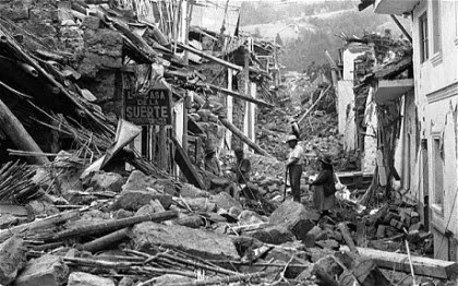
The Ecuador-Colombia earthquake of 1906 was a powerful earthquake that occurred on January 31, 1906, along the border between Ecuador and Colombia. The earthquake had a magnitude of 8.8, making it one of the most powerful earthquakes ever recorded.
The earthquake caused significant damage and destruction in the affected areas, with many buildings being destroyed and landslides blocking roads and transportation routes. The death toll from the earthquake is estimated to be around 1,000 people, with many more injured or displaced.
The Ecuador-Colombia earthquake was caused by the movement of the South American Plate as it collided with the Nazca Plate, which resulted in significant movement along the boundary between the two plates. The earthquake triggered several aftershocks, and the effects were felt throughout the region.
6. Maule(Chile) Earthquake (2010)– 8.8

2010 Maule Earthquake, also known as the 2010 Chile earthquake has occurred off the coast of central Chile on Saturday, 27 February at 03:34 local time (06:34 UTC) about 3 km (1.9 miles) off the coast of Pelluhue commune in the Maule Region, Chile. The intense shaking lasted for about three minutes. Several coastal towns in south-central Chile were devastated by the tsunami triggered by the earthquake. The tsunami also damaged the port at Talcahuano.
Buildings collapsed in many cities, including the capital, Santiago, causing many deaths. The authorities announced the final death toll of 525 victims and 25 people missing in January 2011.
5. Kamchatka, Russia Earthquake (1952) – 9.0

On November 4, 1952, at 16:58 GMT (04:58 local time) a huge earthquake struck off the coast of Kamchatka Peninsula, in the far east of Russia. It produced a great destructive Pacific-wide tsunami with waves up to 15 meters (50 feet) which caused extensive damage to the Kamchatka Peninsula and the Kuril Islands, left an estimated 10,000 to 15,000 people dead. It was also very damaging in the Hawaiian Islands, but there were no human deaths attributed to the tsunami. The waves traveled as far as Peru, Chile and New Zealand. In Alaska, the Aleutian Islands and California, tsunami waves of up to 1.4 meters (4.6 feet) were observed.
4. Tōhoku Earthquake (2011) – 9.1

On 11 March 2011 Friday, at 14:46 with the local time (05:46 UTC), a massive undersea megathrust earthquake off the coast of Japan occurred. The earthquake triggered a massive tsunami with waves up to 40.5 meters (133 feet) high. It was one of the deadliest in human history, the waves traveled inland as far as 6 miles (10 km) and caused extensive and severe structural damage in north-eastern Japan. Airports, roads and railroads destroyed, 127,290 buildings totally collapsed, 272,788 buildings half collapsed, and another 747,989 buildings partially damaged. A dam collapsed. The tsunami also caused nuclear accidents, primarily the level 7 meltdowns (means a Major accident, highest level, see notes 2) at three reactors in the Fukushima Daiichi Nuclear Power Plant complex.
On 10 March 2015, it was announced that the confirmed casualties were 15,894 deaths, 6,152 injured, and 2,562 people missing.
3. Sumatra Earthquake (2004)– 9.1
One of the deadliest natural disasters in recent history, the 2004 Sumatra Earthquake, also known as the 2004 Indian Ocean earthquake, occurred at 00:58:53 UTC on 26 December with the epicenter off the west coast of Sumatra, Indonesia. It ruptured the greatest fault length of any recorded earthquake, spanning a distance of 1500 km (900 miles). The resulting tsunami, with waves up to 30 meters (100 ft) high, caused up to a quarter of a million deaths.

The earthquake had also the longest duration of faulting ever observed, between 8.3 and 10 minutes. It caused the entire planet to vibrate as much as 1 centimeter (0.4 inches). Total energy released by the quake was 4.0×10²² joules (4.0×1029 ergs), or 9,600 gigatons of TNT, 550 million times that of Hiroshima atomic bomb. The vast majority of this energy was underground. The energy released on the Earth’s surface was estimated at 1.1×10¹⁷ joules or 26 megatons of TNT. This energy is equivalent to over 1,500 times that of the Hiroshima atomic bomb, but less than that of Tsar Bomba, the largest nuclear weapon ever detonated.
The resulting tsunami was given various names, including the 2004 Indian Ocean tsunami, South Asian tsunami, Indonesian tsunami, the Christmas tsunami (there were also hundreds of thousands of Christian tourists in the areas affected by the tsunami), and the Boxing Day tsunami.
2. Great Alaska Earthquake (1964)– 9.2
The 1964 Great Alaska earthquake (also known as Good Friday earthquake) occurred at 5:36 PM (local time, 3:36 UTC) on Good Friday, March 27 in the Prince William Sound region of Alaska. It lasted approximately 4.5 minutes and is the most powerful recorded earthquake in U.S. history.

The earthquake triggered 27-foot (8.2 meters) tsunami which destroyed the village of Chenega, killing 23 of the 68 people who lived there. Survivors out-ran the wave, climbing to high ground. It also caused a massive underwater landslide. Port Valdez city harbor and docks were collapsed, 30 people perished.
A total of 139 people are believed to have died: 15 as a result of the earthquake itself, 106 from the subsequent tsunami in Alaska, 5 from the tsunami in Oregon, and 13 from the tsunami in California
1. Valdivia Earthquake (1960)– 9.5

Also known as the Great Chilean earthquake (Spanish: Gran terremoto de Chile), it was the most powerful earthquake ever recorded. The earthquake hit on May 22 in the afternoon (19:11 GMT, 15:11 local time), approximately 100 miles (160 km) off the coast of Chile, parallel to the city of Valdivia. It lasted approximately 10 minutes and triggered a massive tsunami with waves up to 25 meters (82 feet). The main tsunami severely battered the Chilean coast, and raced across the Pacific Ocean and devastated Hilo, Hawaii. Waves as high as 10.7 meters (35 feet) were recorded even 10,000 kilometers (6,200 mi) from the epicenter, and as far away as Japan and the Philippines.
The death toll of 1960 Valdivia Earthquake is not certain – the total number of fatalities from the earthquake and tsunamis have been estimated between 1,000 and 6,000. About 3,000 people were injured.


")
")